Showing 11020 items matching " land"
-
 The Beechworth Burke Museum Research Collection
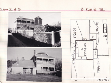
Card (Series) - Index Card, George Tibbits, 8 Kars Street, Beechworth, 1976
George Tibbits, University of Melbourne. Faculty of Architecture, Building and Town & Regional PlanningIndex system that support the research for Beechworth : historical reconstruction / [by] George Tibbits ... [et al]Arranged by street names of BeechworthEach index card includes: street name and number of property, image of property, allotment and section number, property owners and dates of ownership, description of the property according to rate records, property floor plan with dimensions.beechworth, george tibbitsbeechworth, george tibbits -
 The Beechworth Burke Museum Research Collection
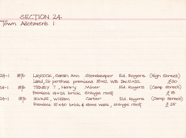
Card (Series) - Index Card, George Tibbits, Camp Street, Beechworth, 1976
George Tibbits, University of Melbourne. Faculty of Architecture, Building and Town & Regional PlanningIndex system that support the research for Beechworth : historical reconstruction / [by] George Tibbits ... [et al]Arranged by street names of BeechworthEach index card includes: street name and number of property, image of property, allotment and section number, property owners and dates of ownership, description of the property according to rate records, property floor plan with dimensions.beechworth, george tibbitsbeechworth, george tibbits -
 Phillip Island Conservation Society Inc.
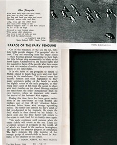
Work on paper - Photocopy of newsletter article, Gould League of Bird Lovers, "Parade of the Fairy Penguins", 1966
By 1966 when this poem and article were written by these state school students, the Phillip Island Penguin Parade had become famous and was a regular excursion destination for groups. The poem in rhyming couplets of 4 lines per stanza is typical of its time with human-centric description of the penguins in 'coat and tails', but both the poem and essay also indicate a growing interest in the evolution and behaviour at sea and on land of the Little Penguins. The Gould League of Bird Lovers, Victoria branch, which published these pieces in their 1966 edition of the Bird Lover magazine, was established for both children's 'nature studies' within school curricula, and for adults. The League published many booklets, posters and newsletters for schools and naturalists. The article demonstrates a growing interest in state schools in teaching students about Australian wildlife at the time. Little Penguins are very appealing to humans and given the accessiblity for viewing them at the Phillip Island Penguin Parade, provided teachers and students an ideal springboard for learning. Encouraging both poetry and essay form also indicated a broad approach to allowing students to express their knowledge and attitudes in various ways within the school setting.Also demonstrates the influence of the Gould League of Bird Lovers within the Victorian Education system.Photocopy of article. Black print on white paper with single greyscale image. Three-stanza poem "The Penguin" by Janice Ah Kee, followed by 4-paragraph description of life in the rookery by Diana Joseph. Both from Victorian state schools.litte penguin, fairy penguin, , bird lover, state school 3125 eagle point, state school 4655 morwell, janice ah kee, diana joseph, christine ryan photo, phillip island penguin parade, gould league of bird lovers, gould league of victoria, phillip island nature parks -
 Wodonga & District Historical Society Inc
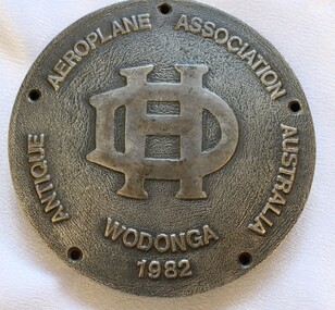
Medal - Antique Aeroplane Association Wodonga Medallion, 1982
This medallion was produced to commemorate the Antique Aeroplane Association of Australia's annual air show which was held at Wodonga. It took place at Joe Drage's Air World Museum in Wodonga, Victoria. The event included a fly-in by members of the Antique Aeroplane Association which attracted vintage planes from all parts of Australia. This medallion and 2 other linked medallions were owned by Mr. Clive Cossor. He spent a lot of time at Drage's Historical Aircraft Museum and also helped transport gliders. He was also at the Albury racecourse as a teenager to assist in moving the Uiver when it was forced to land in a storm during the MacRobertson Trophy Air Race from London to Melbourne in October 1934.This medallion is significant as it records an important event recognising aviation in Australia.A medallion produced to commemorate the Antique Aeroplane Association of Australia's annual air show held at Wodonga. Around edge of the front of medallion "ANTIQUE AEROPLANE ASSOCIATION AUSTRALIA WODONGA 1982" with the De Haviland logo in the centre, On the reverse side "SPONSORS/RADIO/2AY/ALBURY-WODONGA" 8aviation history, antique aeroplane association of australia, joe drage airworld, airshow wodonga -
 Melbourne Legacy
Letter - Document, letter, Sale of properties, 22 Selwood St, Hawthorn East, 9 The Avenue, Windsor, 2003
Two documents that show that in 2003 Melbourne Legacy decided to sell two of its properties, 22 Selwood St, Hawthorn East and 9 The Avenue, Windsor. This decision was taken due to rising maintenance costs and that the money raised from the sale of the properties could be used to benefit all 24,000 widows under their care. One document was a statement by President Tony Parkes about the decision and the other a letter from Jellis Craig offering to be involved in the sale. They had read about the decision in the Leader newspaper. No time frame had been set and all residents of these two properties would be consulted by Legacy personnel with a family member present. Also photocopies of the two land titles for the properties.This shows the commitment of Melbourne Legacy to ensure that residents individual circumstances, accomodation, needs preferences and location were considered in the move, and cause as little disruption to the residents as possible.Cream A4 paper, plus brochure from real estate agent, Jellis Craig,Stamped 'Received 09 JAN 2003 Melbourne Legacy' in blue ink, top left hand corner. Top centre Jellis Craig letter head. Letter signed Peter Batrouney and Micheal Armstrong (Jellis Craig).widows, properties, titles -
 Merri-bek City Council
Lithograph, John Wolseley, After the Fire - Leaf Surge, 2003
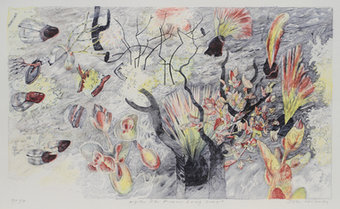
British born artist John Wolseley relocated to Australia in 1976, where he travelled extensively through the outback mainly recording the natural history of remote north Australia in large, minutely detailed paintings. Since 2009, he has travelled to Darwin annually to continue his exploration of the Top End, visiting Arnhem Land and Daly River to work with Indigenous artists to research and capture the detail and essence of particular landscapes. His works reflect how landscape can be thought of as fields of energy in which plant forms move or dance with rhythmic life. After The Fire - Leaf Surge represents the vibrant regrowth of new foliage emerging from a landscape recently ravaged by fire. -
 Eltham District Historical Society Inc
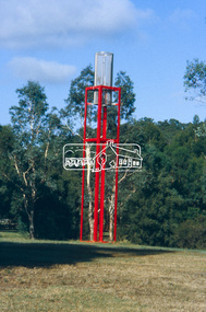
Slide - Photograph, Sensory Integration Invention A, Cathy Smith (1999), Fergusons Paddock, Arthurs Creek Road, Hurstbridge, c.Nov. 2001
Sensory Integration Invention A, by Cathy Smith public art sculpture, commissioned by Nillumbik Shire Council, in Fergusons Paddock,12 Arthurs Creek Road Hurstbridge was officially unveiled in 1999. Councillors Penny Mullinar and Margaret Jennings in attendance. "Smith's work has strong references to humans' sensory and practical relationship with the land through the built environment. Wind entering the structure's tubing operates like a flute, generating sounds such as bird calls that resonate into the surrounding wetland areas." Source: Highlights from the Nillumbik Public Art Collection, NSC, n.d. Part of a slide show presentation "A Trip Down the Diamond Creek" by Russell Yeoman to the Eltham District Historical Society meeting of 14 Nov. 200135mm colour positive transparency Mount - Black and Whiteart in public places, arthurs creek road, cathy smith, ferguson's paddock, hurstbridge, public art, sensory integration invention a -
 Eltham District Historical Society Inc
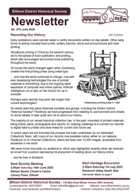
Journal - Newsletter, Newsletter, No. 270 June 2023
Contents: • Recording Our History by Jim Connor • Our Next Meeting - 2.00pm Saturday 10th June 2023 • Heritage Walk - Saturday 1st July 2023 - Research Valley South Side • Eltham Horse and Pony Club by Tony Brocksopp • What’s Happening by Liz Pidgeon • Frank’s New Shoes by Jim Connor • Many Hands Make Flags Fly!! By Terry Beaton • A Catalogue of Killings by Richard Pinn • Early Land Sale Documents • Annual General Meeting - Saturday 15th April 2023 • Eltham Cemetery Stories by Liz Pidgeon o Anne Hunniford, (Burgoyne) nee Hamilton, 1813-1899, Pioneer o Anne Jane Hunniford 1855-1927, Post Mistress The Shire of Eltham Historical Society was formed in October 1967. The first newsletter of the Society was issued May 1978 and has been published continuously ever since on a bi-monthly basis. With the cessation of the Shire of Eltham in late 1994, the Society's name was revised to Eltham District Historical Society and this name first appeared with issue No. 103, July 1995. The collection of the Society's newsletters provides a valuable resource on the history of the Society's activities, office bearers and committee members, guest speakers and subjects of historical interest pertinent to the former Shire of Eltham and the Eltham District.A4 newsletter distributed to members (Digital and A4 photocopy)newsletter, eltham district historical society -
 Sunbury Family History and Heritage Society Inc.
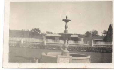
Photograph, Emu Bottom
The fountain in the image is at the entrance to the 'Emu Bottom' homestead. George Evans squatted on land to graze sheep, along the Jacksons Creek Valley, originally known as Buttlejork Valley, in 1836 and built the homestead from local Silurian sandstone and timber. Over the years it has had a number of owners. In the 1920s the property was renamed 'Holly Green' by H.L Webb after a property in Narre Warren.In the 1950s it was renamed 'Emu Bottom'. Over the years a number of fires have destroyed parts of the building and as a result, little of the original building remains. The fountain was erected in 1936 to mark the centenary of the property as well as 100 years of European settlement in theSunbury area. The property is now a private residence and function centre.'Emu Bottom' is one of the oldest homesteads in Victoria.A small non-digital sepia photograph with a cream border of a fountain, with a horse trough around the base, at the entrance of a rural property.'emu bottom', holly green, sunbury, jacksons creek, buttlejork valley, george evans -
 Kew Historical Society Inc
Work on paper - Sepia Wash & Ink, G B Richardson, Creek and Old Watering Stage, on the Yarra, East Collingwood, 1854, 1854
Blind Creek was located between the Abbotsford Convent and what is now the Collins Bridge in Studley Park. In an 1858 map of East Collingwood by Clement Hodgkinson, in the State Library of Victoria, one can see how the creek was originally a significant landmark in Collingwood; remaining vacant land until a barrel drain enclosed it. The area was later filled in, surveyed and developed. The position where Blind Creek entered the Yarra was in the immediate vicinity of Hodgson’s Punt, which had linked Kew to the other side of the Yarra from 1839. The Punt was purchased by the Colonial Government in 1852 and was in use until the opening of the Studley Park Road (Johnston Street) Bridge in 1858 made its continued use redundantThe point of view selected by the artist for the watercolour is from the banks of Blind Creek in East Collingwood, looking across the Yarra to the Kew side of the river.Inscribed verso 'Creek and Old Watering stage, on the Yarra East Collingwood 1854 / Trees, stage, &c have long since disappeared / [Artist Signature] / FT 110 / Creek itself now being filled in 1903.gb richardson, blind creek - abbotsford, yarra river - abbotsford (vic) - kew (vic), colonial artists, australian art - 19th century, george bouchier richardson -
 Surrey Hills Historical Society Collection
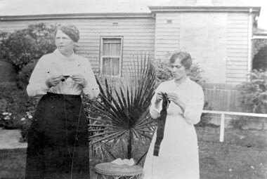
Work on paper - Photograph, Jane Slessar knitting for the Red Cross, WW1, 1914
Knitting socks for soldiers in the trenches in France was a common women's activity during WW1. Often white wool was knitted up and Condy's crystals were used to dye the socks a khaki colour. Jane Cook married William Slessar (land agent / farmer) in 1887. They had a family comprised of at least: Arthur, Frederick Alan, Gladys Isabella, William Cook, William Kenneth, Robert Harold. They lived at 17 Albert Crescent, Surrey Hills. William died in 1921; Jane in 1952 aged 90. They are buried in Box Hill Cemetery B-0086. Their son Arthur is buried with them. Their son William Cook Slessar was Killed in Action on 24 June 1916 in Belgium.Black and white photo of 2 women standing in a garden knitting. One is identified as Mrs Jane Slessor; the other is a younger woman. Between them is a cane table and a small palm. In the background is the side of the adjacent property - a timber Victorian home.knitting, red cross, world war, 1914-1918, albert crescent, box hill cemetery, jane slessar -
 Glen Eira Historical Society
Document - Grange Road, 77, Glen Huntly
This file contains 4 items about the purchase and construction of this property: 1/ The original contract of sale of land dated 25/09/1936 for Gertrude & Hulbert Gorrie situated on the corner of Grange and Neerim Road. 2/ The original typed building agreement dated 25/09/1936 between the contractor Ernest F Barnard and the purchasers Mr & Mrs Hulbert Gorrie. 3/ The original blueprint plan of a brick villa at the corner of Grange & Neerim Road for Mr & Mrs Hulbert Gorrie. Dated 25/09/1936. 4/ The original specification for the dwelling on the corner of Grange & Neerim Road, Glen Huntly for Mrs Gertrude Gorrie & Mr Hulbert Hopetoun Gorrie by builder Ernest F Barnard.barnard ernest f, gorrie gertrude, gorrie hulbert hopetoun, hobart john bertram, coorigil road, carnegie, holloway st, ormond, chemists, parish of prahran, caulfield county of bourke, building agreement, brick houses, builders, plans, architectural drawings, grange road, glen huntly, holloway street, ormond, emma street, grange road, neerim road, gorrie h.h, gorrie gertrude, gorrie hulbert h, legal documents, barnard ernest franklin, e. j. & h. amos, hintons nursery, real estate agents, murrumbeena, caulfield -
 Old Colonists' Association of Ballarat Inc.
Photograph - Image, The History of Charles Anderson and Charles Anderson Grove, Ballarat
Information relating to Charles Anderson and Charles Anderson Grove, Lake Gardens, Ballarat. The Old Colonists' Association Ballarat Inc. is a not for profit charitable organisation providing accommodation for elderly people. It manages a 27 Home retirement village at Charles Anderson Grove, Ballarat. Accommodation is offered at significantly below market rates. It has been providing low cost accommodation to the elderly since the 1920s. The Association Council overseas the running of this facility on a voluntary basis. HISTORY OF THE BALLARAT OLD COLONISTS' ASSOCIATION HOMES AT CHARLES ANDERSON GROVE, LAKE GARDENS One of the original objectives of the Association was “to provide the shelter of a house for those Pioneers of the Goldfields whom the reverses of fortune have deprived of the means of procuring the comforts of life in their declining years.” While the first home at Charles Anderson Grove was built in 1925 the Association had previously provided relief for needy pioneers from the time it was formed in 1883. Relief included monthly monetary payments, loads of firewood, medical assistance and distribution of Christmas boxes of groceries to deserving pensioners and in some cases payment of burial costs. Records indicate that in September 1922 three of the pensioners being assisted by the Association were accepted as residents in the newly erected Hassell Homes in Gillies Street (now demolished-opposite the High School). The first site for an Asylum for Indigent Members of the Old Colonists' Association was temporarily reserved from sale in October 1891. The site was approximately 28 acres in area in Mt Clear nearly opposite Midvale Shopping Centre in Main Road. The site was heavily timbered and when cleared over 260 tons of wood was sold to the Woah Hawp Gold Mining Company. A set of gates were erected but no homes built, although a plan for this reserve was drawn which showed twenty buildings ranging from one to four unit per building. The reserve was revoked in November 1909. The second site temporarily reserved in November 1909 as an Asylum was in Alfredton and consisted of some 7 acres and was adjacent to land reserved for an Abattoirs for the Ballarat Council. The reserve was revoked in February 1912 as it was deemed more appropriate to be added to the Abattoir site. Council suggested four (4) other sites in exchange for this land and they were inspected by the President, Vice President and Secretary on 22 December 1912. The first site inspected was land on the west side of Creswick Road opposite the brick kilns (now occupied by the showgrounds and oval). The land was described as being good quality, well fenced, no trees, good drainage and ample acreage but some distance from trams. The second site was Perry Park which was described as being good land, well fenced, having frontage to Gillies Street, good drainage and about 26 acres (but subsequently reduced to 10 acres). It was closely planted with Pinus Insignias and Wattle and had easy access from the Botanic Gardens tram. The third site was the North West portion of Victoria Park (corner of Sturt and Gillies Street) and was described as good land, well fenced and drained and well located. The fourth site was the South West corner of Victoria Park and known as Pound Paddock (corner of Winter Street and Gillies Street). It was considered to be low lying and too close to the Abattoir, and was also a considerable distance from trams. While the third site was recommended as the most suitable for the erection of homes it was considered unwise from the point of view as citizens to reduce the acreage of the park and therefore it was recommended that the Perry Park site be asked for as the most acceptable to the Association for the building of homes. The site was eventually temporarily reserved for an Asylum for Indigent Members of the Association in April 1914 with the gates from Mt Clear having been removed to the site a year earlier and eventually erected in 1917 for £12.10.0. In the same year the first 290 pine trees were advertised for removal in July and sold for £16. A sign indicating that the site was reserved for the erection of cottages was erected in September 1917. Stripping of the wattle bark (for tanning) and the cutting of the wood occurred in November 1918 with the land then being leased until it was required for the construction of the first homes in 1924. While the site was the third to be reserved it was the only one which was used for its intended purpose. It was named as Charles Anderson Grove in honour of Charles Anderson who joined the Association in 1918 and was President of the Association from 1942 to 1944. CHARLES HENRY GRATTAN ANDERSON C.H.G. Anderson (Electoral Returning Officer) was elected to membership of the Old Colonists' Association, Ballarat, in October 1918. He was elected to the Association Committee in 1926, and appointed Treasurer of the Association on the resignation of F. Ellis until the end of the financial year in 1933. In 1936 Charles Anderson indicated he would not be available for the President's Chair and that he would retire from the Committee owing to pressure of work. C.H.G. Anderson was welcomed as a new member of the Association in 1938, and served as President of the Old Colonists' Association from 1942-1944. Midway through 1949 Charles Anderson was appointed Members Secretary and Manager of the Ballarat Old Colonists' Club at £5.0.0 per week and 10/- for entertainment, to commence work prior to 01 August 1949. He was to do 30 hours per week and be present on Friday and generally on Saturday nights. In 1957 a minute of sympathy was extended to Club Manager Charles Anderson on the loss of his son. In 1958 a bonus of £20.0.0 was paid to Charles Anderson in recognition of his service in assisting the Secretary/Manager taking over under difficult conditions. In March 1964 the Shire of Ballarat would not permit a private road to be named Anderson Grove as Anderson Street already existed in Ballarat but Charles Anderson Grove was deemed acceptable. A recommendation of the Committee was put to the AGM in 1967 that Charles Anderson be made a Life Member. In 1969 an Association meeting observed a minutes silence in memory of Chas Anderson. Charles Anderson was also a Committee member of Ballarat Mechanics' Institute from February 1940 to February 1970. He was President in 1948. Black and white photographic portrait of Charles Anderson.charles anderson, charles anderson grove, ballarat old colonists' club, old colonists' association, ballarat, ballarat mechanics' institute, hassell homes, woah hawp gold mining company, firewood, retirement village -
 Melton City Libraries
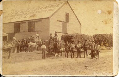
Photograph, 'Melton South Chaff Mill employees, Unknown
Charles E “Ernie” Barrie started constructing a Chaff mill on the corner of Brooklyn and Station road in 1900. It soon became a thriving business and was ideally located close to the railway line. Ernie and his father William and other Barrie brothers had been operated travelling chaff cutters in the district of Melton and Werribee. Within a short time the mill expanded into two big sheds in partnership with his brother James E known as “Ted”. The eldest brother William was in the Manager living in Melton South. In 1906 Ernie applied for a railway crossing on Brooklyn Road to have direct access for railway trucks to be shunted to the mill to be loaded. The Mill was also had the first phone to be connected, No 1, and No’s 2, 3 were the Golden Fleece and Macs Hotels. In 1906 Ernie married Jessie Lang daughter of the Head Teacher at Melton State School No 430 (1896 –1917). The Barrie house on the north side of the mill was completed in August 1906. It survived for almost 60 years until demolition. Chaff mills were very susceptible to fires and often burnt down and would be rebuilt again ready for the peak of the harvesting season. The final demise of the Mill occurred in a spectacular blaze on the night of Friday 2nd December 1977, just before the earth tremor as reported in the local paper. Brian Dobson the local photographer lived close by and captured the night blaze. A video was also taken of the action by the fire brigade. My parents Bon and Edna Barrie were living at 19 First Avenue, and took colour slides of the smouldering ruins in the half -light. Ironically Bon had spent the first year of his life (born in April 1909 and sister Mary born October 1907) at the house beside the mill. Trethowan’s Chaff mill in Brooklyn road was also destroyed by fire, which stated in the evening on Tuesday April 28th 1987. It was established in 1910 by Dixon Brothers, followed by, Ebbot & Kebby, Robinson, Trethowan and Butler and was with the Trethowan family when it burnt down. Melton South was small a community referred to as Melton Railway Station. Member of the community raised the idea to have a public hall. In 1909 Cr Barrie, Mr Nesbitt and Delany formed a committee to build a community hall. Cr Barrie donated the land and The Exford Hall was completed in September 1910 later to be named Victoria Hall. It was demolished in 1992. Colour slide in Barrie archive. In April 1910 the Ernie sold the Mill to Glover Onians (HSK Ward) family moved away to a property in Trundle NSW. Ernie had acquired 640 acres (a square mile) and leased a further 1920 acres of adjoining land. It was the practise of the farmers in the area at the time to buy up or lease the surrounding land from the 640 acre crown land blocks to make up acerage for a viable wheat farm. His wife Jessie found the climate to be very hot and when the Darlingsford property at Melton was put up for sale in the latter part of 1910 and was passed in at the auction. My grandfather saw this an opportunity to return to Melton. The negotiations to Darlingsford were finalised on May 11th 1911. Barrie bothers with connections to Chaff mills and farming in Melton from the 1900s William Henry, Charles Ernest, James Edwin, Samuel John, Robert, Arthur Roger, Albert Walter. Three grandsons and a great-grandson are in business earthmoving and farming in Melton today. (2013) Memoirs by Wendy BarrieEmployees at Chaff Mill, it was located on the corner of Brooklyn and Station Road, Melton South. local identities, agriculture -
 Bendigo Historical Society Inc.
Newspaper - HOWARD AND VIOLET JOLLEY COLLECTION: NEWSPAPER
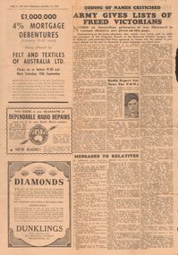
From The Sun of Wednesday Sept 12 1945, a, page 6, Coding of Names criticised ARMY GIVES LISTS OF FREED VICTORIANS listing names so identified, and message to relatives, included a reference to J. F. Dale to his parents H. C. Dale of 47 Joseph Street Bendigo. Item re radio expert got news for P.O.W.s and on b, page 5 HIGH PRODUCTION COSY INVESTIGATION; RSL Wants clinics for War Neurosis; BRAVERY EARNS MM; LAND LEASES ADVOCATED Assembly Discussion on Settling Soldiers; WOOL BUYING SCHEME CHANGE SOON; CWA makes Requests; Good homes needed; Decentralization Urged; Peck killed in air accident. C Page 27 of the Advocate April 13 1939, Requiem for Late Father Ronan, popular Bendigo Priest. This page also has advertisements for the Beehive, Davey & Waddington, Matthews Bros, Sandhurst and northern district Trustees, W. Ewing & Son, H & C Styles, McEncroe Milk Products. -
 Bendigo Historical Society Inc.
Document - PRESENTATION TO BHS 7TH JULY 2000: ''CAMP RESERVE'', 7th July 2000
Presentation by James Lerk to BHS 7th July 2000: ''Camp Reserve -Rosalind Park, used and abused''. First line: ''This short paper has no pretension in giving a complete synopsis regarding a slice of land which cradles a great deal of the history of Bendigo''. References to Commissioner Gilbert; Bank of Victoria; Bendigo Bank; powder magazine; post office; Survey Office; Court of Petty Sessions; Police Barracks; Supreme Court; Gaol; Temperance Society; Robert Strickland residence; tenements on Reserve; Mac's Track; Orderly Room; Cascades; Corporate High School; Temperance Fire Brigade; Masonic Hall; Central School Camp Hill; Fernery; ''The Willows''; Conservatory; Parade Ground; Sandhurst Club; Police Station; Grandstand in Upper Reserve; High School; Soldiers Memorial Insitutute; Lookout (poppet head - Garden Gully United); Advance Bendigo and North League crèche; Sound Shell; Olympic Swimming Pool. Two printed copies.James Lerk.bendigo, streetscape, camp reserve, rosalind park, bendigo creek -
 Bendigo Historical Society Inc.
Document - CONNELLY, TATCHELL, DUNLOP COLLECTION: LEGAL PAPERS, 1915 - 1920
Document. Various legal papers. 1 - 1915 -1920 - Moxom Mrs M (Kamarooka, later Bendigo) re costs. 2 - 1920 - Manning Mrs Jane (Bright) re costs Will. 3 - 1920 - Mann Arthur (Nullawill) re costs Weaver. 4 - 1919 - McCormick D (Prairie) re costs. 5 - 1920 - Mann J & N (Bendigo) re costs. 6 - 1919 - 1920 - McManus John & Ors. (Farmers Sea Lake) and McManus William H (Sea Lake). Re costs Lindsay, Weller & C). Contains handwritten letters by William H McManus. 7 - 1920 - Michelson Mrs A I (Bendigo) re costs Leggo. 8 - 1920 - Kerr R H (Runnymede East) Re costs. Re G Kerr. Estate Federal Land Tax. 9 - 1919 - Hartley Bros Pty Ltd (Bendigo) Re costs. Re Butterworth & Rhodes Motor Cycle Coy, Simes, Roberts, Stolen Bicycle. Other names: Simes, Roberts.bendigo, business, connelly tatchell and dunlop, connelly, tatchell & dunlop, moxom mrs jane, mann arthur, weaver, mccormick d, mann j & n, mcmanus john & ors, mcmanus william h, lindsay, weller & c, michelsen mrs a i, leggo, kerr r h, kerr g, hartley bros, butterworth & rhodes motor cycle co -
 Bendigo Historical Society Inc.
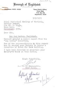
Document - HARRY BIGGS COLLECTION: EAGLEHAWK LOGS APPEAL, 1970
Document. Harry Biggs Collection. Item 1 - A letter with Borough of Eaglehawk letterhead to Mr H. Biggs, Royal Historical Society of Victoria Bendigo Branch, dated 9/9/1970, Re the Log Lock-up, Eaglehawk. It acknowledges a report sent to it & says a request for the Historical Society to become a committee of Trust for this building is being ascertained. Stamped with Reply affirmative11/10/70. Item 2 - a similar letter dated 18/9/1970 saying final decision will be held over. Item 3 - Instruction in letter form to Bendigo Historical Society Eaglehawk to plan & report the proposed Public Buildings Reserve Eaglehawk. Item 4 - Memorandum to Engineer's Report 17/9/1970 with recommendations for the various areas - Court House, Senior Citizens Club, Historical Society, Council Depot, Toilet Block, Occupied Land. Item 5 - Formal Engineers plan of Borough of Eaglehawk. Item 6 - Log Lock-up Appeal - list of donors.place, building, site, harry biggs collection, log lock-up appeal, eaglehawk -
 Numurkah & District Historical Society
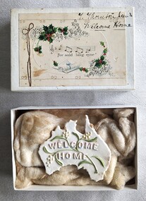
Memorabilia - WW1 & Family Memorabilia - Thomas Thornton
War and family memorabilia collated by Betty Thornton, daughter of local Thomas Thornton. WW1 & Family Memorabilia - Thomas Thornton contains: ~ 2 x leather-bound photo albums containing b&w photos of family members, some labelled with hand-written notes ~ Sample of small stones containing copper ~ Several sized detachable buttons used on WW1 service uniforms (cuffs, collars, shirts) ~ Small purple-coloured cardboard box containing a number of service medals, fund-raising badges, royal family medallions ~ B&W photos of Thomas Thornton and comrades in uniform ~ Small leather-bound book containing information about servicemen known to Thomas Thornton (My Roll of Honour) ~Small white cardboard box containing plaster Welcome Home plaque in the shape of Australia. Lid has floral decoration, Auld Land Syne and Thomas Thornton written in the corner ~ Photocopies of Thomas Thornton's war records (AWM) ~ Homemade cardboard frame covered in clear plastic, containing some WW1 items of Thomas Thornton see photosthornton, ww1, copper, badges, medals, buttons -
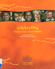 Victorian Aboriginal Corporation for Languages
Book, Rowena Withers, Celebrating Indigenous governance : success stories of the Indigenous governance awards, 2005
Good governance means good business What is governance? The Indigenous Governance Awards Key elements of good governance Finalists 2005: Koorie Heritage Trust, Victoria; Central Australian Aboriginal Congress, NT; Sunrise Health Service, NT; Goldfields Land and Sea Council, WA; Institute for Aboriginal Development, NT; Maari Ma Health Aboriginal Corporation NSW; North Coast Aboriginal Corporation for Community Health Qld; Tiwi Islands Local Government, NT What works: lessons from the 2005 Indigenous Governance awards Governing body: choosing the board; Size and frequency of meetings; Board change and continuity; Processes of decision-making; Making good decisions; Financial decision-making; Accountability tools Managing and implementing decisions: carrying out recommendations; Informing stakeholders Conflict resolution: conflicts among the board; Complaints from members; Staff conflicts Leadership development: developing youth; Staff development and training Cultural norms and values: Boards and elders; Community and culture Future planning.colour photographsbusiness enterprise, indigenous business -
University of Melbourne, Burnley Campus Archives
Plan, [Historical Maps of Richmond Park], 1862-2000
(1) Proposed reserve for Horticultural & Experimental Garden in the Survey paddock Richmond. R.19A (1865). Shows Swan Street Extension. Gazettals 1877, 1887. (2) As (1). Half of map only Annotation by A. Purchas, 9 October, 1862. (3) Plan of Richmond park. A.L. Martin Authorised Surveyor, 31st August, 1872. [Dept. of lands & Survey Melbourne, J. Noone, 6th September 1872.] Map in 4 sheets. (4) Richmond Park. Surveyed by Geo. Black, Authorised Surveyor 13.8.91 (2 copies). (5) [Richmond Park] Shows road alignments gazetted 1871 & 1881 (part copy only - Neg. 18375). (6) City of Richmond Parish of Jika Jika County of Bourke. Department of lands & Survey, 1919 (annotations i.e. Melb. City Link, Amrad, etc. to 1994.) (7) Burnley gardens, 2000. Produced by P. Tulk, Institute of Land & Food Resources, Burnley College, 2000 (re area proposed for heritage listing.)richmond park, survey paddock -
 Bendigo Historical Society Inc.
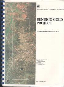
Booklet - Kangaroo Flat Gold Mine Collection: Western Mining Corporation Bendigo Gold Project Environmental Effects Statement December 1987, Western Mining Corporation, Bendigo Office, Western Mining Corporation Limited Bendigo Gold Project Environment Effect Statement December 1987, December 1987
Spiral bound booklet, plastic cover, black plastic binding, On front cover: Western Mining Corporation Bendigo Gold Project, Environment Effects Statement, December 1987. On front page, colour aerial photograph of Bendigo mining areas mentioned in report. Key on front page related to photograph: 1. Woodvale Evaporation Ponds. 2. New Moon area. 3. North New Chum Williams United shaft. 4. Carshalton, Carshalton shaft. 5. South Nell Gwynne, North Bendigo shaft. Contents: historical perspective; Western Mining Corporation Ltd Bendigo activities; project outline, project approvals - controlling factors, elements of the mining project, surface based exploration, underground operations and surface support, mining areas and operations ore and mullock haulage, New Moon area, water management, environmental management. Planning and land use, socio-economic environment, physical environment and biological environment are examined and discussed. bendigo, goldmining, bendigo mining nl, bendigo goldfield, environmental effects statement, bendigo gold project, woodvale evaporation ponds, new moon, north new chum, carshalton, south nell gwynne, western mining corporation -
 Bendigo Historical Society Inc.
Document - INDENTURE, GOLD MINING LEASE 11081 CROWN AND HERBERT JACKSON LEED OF BENDIGO, MCCOLL, RANKIN AND STANISTREET COLLECTION, 21st September, 1940
Six page document plus map, dated 21st September 1940, between the Crown and Herbert Jackson Leed, for the land shown on the accompanying map 'indicated by yellow colour' Depths indicated on lease document. On map: Mining District of Bendigo, County of Bendigo, Parish of Sandhurst. No. 11081. Net Area 24 acres, 3 roods, 3 perches. Signed by Herbert Leed and ?Walsh, Warden Clerk, Bendigo. Map shows lease holding 11081 coloured yellow. Other leases: no's. 9882 11081, 11034, 11080. Streets: Fletcher Street, and Belle Vue Road. Gullies: Derwenters Mistake Bully and Pig Face Gully on lease 11081. Quarry Hill Recreation Reserve marked and some residential allotments. Water race indicated on map. On back of document: ; Deborah United Gold Mining Company No Liability of Charing Cross Bendigo is now the proprietor of the within described estate by transfer registered on 21st November 1940 and numbered 1795202.bendigo, mining, deborah united gold mine, herbert jackson leed, deborah united gold mining. major general sir winston joseph dugan -
 Glen Eira Historical Society
Album - Album page, Bureel (Kooyong Road), Circa 1972
This photograph is part of the Caulfield Historical Album 1972. This album was created in approximately 1972 as part of a project by the Caulfield Historical Society to assist in identifying buildings worthy of preservation. The album is related to a Survey the Caulfield Historical Society developed in collaboration with the National Trust of Australia (Victoria) and Caulfield City Council to identify historic buildings within the City of Caulfield that warranted the protection of a National Trust Classification. Principal photographer thought to be Trevor Hart, member of Caulfield Historical Society. Most photographs were taken between 1966-1972 with a small number of photographs being older and from unknown sources. All photographs are black and white except where stated, with 386 photographs over 198 pages. From: Glen Eira Heritage Management Plan 1996 by Andrew Ward In 1856, John Allee, a builder from Brighton, purchased C.A. 37 on the south-west corner of Glenhuntly and Kooyong Roads. The land comprised just over 45 acres. By 1863, Francis John Sidney Stephen, a lawyer and cousin of J. Wilberforce Stephen, owned most of lot 37. By 1866, Stephen had a built a "small mansion" named ''Burreel". It was a brick house and Stephen lived there until 1882. By 1884, Mrs Buxton of Hillside Terrace, East Melbourne, had purchased the property. Richard Buxton, a gentleman was listed as occupant and the house described as "brick, eight rooms". NAV was £300. Richard Buxton continued residency in 1887 however in 1888, George Allen, music seller, became occupant. At that time the house had thirteen rooms on twenty-three acres of land. Twelve people lived there and NAV was £920. In 1900, Daniel Luxton, stock and sharebroker and the Honourable John Taverner, M.H.A. leased the property. Fourteen people lived there. Mrs Buxton continued as owner. By 1910, ownership had passed to Mrs Mary Neate, who converted the house to a nursing home. The land had been subdivided by 1913 and sold by ''Buxtons Estate". Burreel Avenue, Baxter, Buxton and Hoddle Streets were created. "Burreel" was rated to Burreel Avenue and stood on lot 13 with frontages to Burreel Avenue and Kooyong Road of 198' and 214'. The house had ten rooms. NAV was £60. Mary Neate, a nurse, continued as owner/ operator of ''Burreel" nursing home in 1927. At that time there were sixteen rooms and fourteen residents. NAV was £100. Mrs Neat remained there until 1947. In 1948, the house was turned into apartments. In the 1980's, the Alexander family purchased it and restored it to a private residence.Burreel 331 Kooyong Road, ELSTERNWICK VIC 3185 - Property No B4950 National Trust https://vhd.heritagecouncil.vic.gov.au/places/65648 This is a large and substantially intact example of the grand villas of nineteenth century Melbourne. The bulk of the house most probably was built in 1866-1868 for Francis John Sidney Stephen, a prominent and highly regarded Melbourne solicitor and a member of an illustrious legal family. Stephen conducted a lucrative private practice and in 1845 was appointed first solicitor to the City of Melbourne; a position he held until his death in 1895. He took an active part in the development of Caulfield and was Shire President in 1874 and 1877. He was a resident at Burreel from 1868 to 1882. The house has evolved in stages, the rear wings possibly remaining from a house built during the 1850s. The existing ornate cast iron verandah was probably built between 1882 and 1888 during the residence of Richard Buckhurst Buxted, a notable boom period auctioneer and real estate agent. George Allan, the founder of Allan's music store, was another important occupier from 1888 to 1991. Bureel's essentially residential quality has been retained and the interior has been well preserved. The significance of this building does not rest in any single unusual outstanding architectural feature, or in its association with a particularly prominent member of society in the past, but rather in the consistent integrity of both the interior and exterior, which results in the survival of an outstanding example of this type of residential building and its associations with two notable citizens. Classified:11/08/1990Page 113 of photograph album with 1 photograph of Burreel in its garden.Handwritten: Bureel [top left] / 113 [bottom left]trevor hart, caulfield, caulfield north, kooyong road, thomas king, mansion, 1860's, bureel, burreel, francis john sidney stephen, city of melbourne, shire president, 1850's, verandah, nursing home, john allee, ornamented corner stones, new orleans manner, plaster rendered, mrs luxton, vincent willis, alexander family, victorian architectural style, ornate cast iron work, lawyers, brick houses, richard buxton, richard buckhurst buxton, george allen, george leavis allan, allans music, daniel luxton, john taverner, mary neate, buxtons estate, land subdivision, mary neat, gardens -
 City of Moorabbin Historical Society (Operating the Box Cottage Museum)
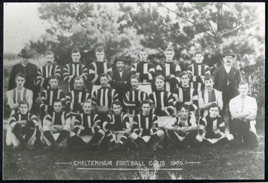
Photographs, x 3 Black & White Cheltenham Football Club 1909,1913, 1946, 20thC
Known as the Rosellas, the early Cheltenham Football Club sides began playing on a regular basis in 1890, and would travel long distances by steam train to play country teams, such as Ballarat where they would arrive at their destination, play the match, socialize then return to the station. Opposition players and supporters would give three hearty cheers on their departure. The Cheltenham home games were played on a paddock on the corner of Park and Charman roads in Cheltenham. In 1907 the Cheltenham progress committee made an application to the board of land works for land in Weatherall Road for recreational service to the public. That application was received and granted, then developed where Cheltenham Recreational Reserve now stands. The land in the early days was virgin bush and the response for voluntary help to clear the area was outstanding. Nearly all the market gardeners in the district along with horses, ploughs, axes, shovels completely cleared the area in three weeks. The Moorabbin council then leveled the playing area and erected a post and rail fence around the ground. Pine tree shrubs were then planted on the west side of the ground. The ground was opened in 1909 and the first Cheltenham side entered in the newly formed Federal Football Association along with seven other foundation members, Mordialloc, Mentone, Moorabbin, Frankston, Glenhuntly, Elsternwick, and Ellindale. The grand final for that year, 1909 was a hard encounter between Cheltenham and Ellindale with Cheltenham coming out victors, thus becoming the inaugural Federal Football Association premiers. Cheltenham went onto win five senior premierships in the Federal Football Association by the end of the 1920s, they won the flags in 1909, 1911, 1913, 1922 and 1925, with the late Percy Woff playing in all 5 premiership sides and was captain in 1922. 1928 saw the start of an outstanding career from our oldest living player Tom Connor. Cheltenham continued to win premierships in the 1920’s and 1930’s with juniors taking out the 1929 and 1933 flags, under the guidance of Woff, and that continued in 1934 when Cheltenham took out the 1st XVIII and 2nd XVIII premierships. Cheltenham produced its only Brownlow medallist in Peter Box who played in the late 1940s, before going to Footscray where he became a champion. The 3rd XVIII went through the season undefeated in 1974 winning the premiership, with Trevor Barker a key player before going to St Kilda the following year. The club won three senior premierships under coach Barry White in 1992, 1993 and 1995. ( from CFNC website 2019) Cheltenham Football Club was formed 1890 and succeeded in winning many Premierships as a member of the Federal Football Association, Outstanding players Peter Box Brownlow Medalist 1956 Footscay VFL, , Trevor Barker and Kevin Roberts St Kilda VFL.3x Black & White photographs of the players in the Australian Rules Cheltenham Football Club 1909, 1913 and 1946 extra photo of Peter Box Folio 10 MAV 01059a) CHELTENHAM FOOTBALL CLUB 1909 Cheltenham Football Club 1909. Back row: A Chandler, committee member; R. Robertson, back-pocket; J. Harris, half back flank; J Adams, ruck and forward-pocked; M. J. Monk, club president; L. Woff, back-pocket; W. Adams, ruck and back-pocket; P. Woff, rover and forward-pocket; A Monk, committee member. Middle row: W. Hore, back pocket and ruck; A. Towns, half-forward flank; W. Carson, full back; F. Andrews, captain-half forward flank; H. Butler, centre half back; J. Warburton, centre half-forward; A. Slater, half-back flank; F. Fisher, half-forward flank; C. Sherwood, trainer. Front Row: G Gouldthorpe, wing; H. King, full-forward; W. Johnston, ruck and forward-pocket; P Spears, rover and forward-pocket; F. Bichl, wing; A. Bichl. rover and forward-pocket; F. Butler, centre player. Courtesy, Lionel Seal. ( from CFC website 2019) b) CHELTENHAM 1913 PREMIERS c) CHELTENHAM -1946 / Back row - J. Fisher, G.Corrigan, N.Hocking, F.Virtue, R.Craven, L.Baker, M.Blundell / 2nd Row - J.Phillips, T.Connor, E.Hawkins, A.Blakely, G.Baker, A.Dark, J.Barker, D.Craven, J.Pickering, P.Cameron,/ W.Hicks, G.Hoskings, R.Beihl, A.Hubbard, R.Kier, C.Russell. / Front Row - Clark Taylor, J.Slade, N.Niel, J.Brooks, T,Butler, H.Hosking, C.Hacusler, E.Hornibrook, W.Briggs, B.Russell, L.Biehl, / W Ripponcheltenham football club, australian rules football, victorian football association, victorian football league, smith j l; smith mary ann, stanley helen, , chaff cutter, horse drawn carts, toll gates brighton, motor cars 1900, steam engines, early settlers, bentleigh, parish of moorabbin, city of moorabbin, county of bourke, moorabbin roads board, shire of moorabbin, henry dendy's special survey 1841, were j.b.; bent thomas, o'shannassy john, king richard, charman stephen, highett william, ormond francis, maynard dennis, market gardeners, vineyards, orchards, cheltenham, two acre village, holloway josiah,, woff percy, connor tom, box peter, barker trevor, white barry, browlow charles, -
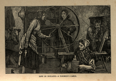 Ballarat and District Irish Association
Image, Life in Ireland - A Farmer's Cabin, c1864
The tenant lived at the mercy of the resident landlord. Home was a one-roomed house, a chimney of wicker work plastered over with mud or just a hole in the roof. The walls might consist of mud too, or sods of grass. Any windows, were rarely glazed and would be open to the elements all year round. The Pig, if any, was kept in the house, the most valuable possession. Sold for cash at local market. The main items in the house were a potato pot and water bucket. As well as mother, father and children, there could well be grandparents all living in the same cramped conditions. The family would sleep on rushes or straw lain on the floor. Most tenants were tenants 'at will ', which meant they could be evicted at the 'will' of the landlord. Some had a lease for the life of the father and the eldest son, and this meant they were relatively safe from eviction as long as they could pay their rent. There was a tradition of passing on a portion of your land from father to each of the sons, who would build a small dwelling, and in turn pass a portion onto their own sons. This cycle of subdivision meant that many families were surviving on a tiny plot of land from which to derive a crop of potatoes for the year. Women worked hard in this environment, rearing children, cooking, cleaning, tending to any animals such a pigs or chicken and when needed, helping in the potato field. Life was dictated by the annual rent due to the landlord. Other typical expenses could be the Hearth Tax (actually charged by the number of fire places in a house) Turf, Hay (for any farm animals) and tithes. A tax known as the tithes were calculated at one tenth the value of everything saleable. Tithes were a bitter issue. They were for the support of the Church of Ireland, Protestant Bishops and Ministers, and a cess tax for the construction and maintenance of Protestant Church buildings. The problem being that the vast majority of those paying the Tax were Catholic and paying to support something that was contrary to their beliefs. Potatoes were the staple diet from September through to the end of Spring of the following year. But the summer months were months of hunger and hardship as they waited for the following harvest to come in Autumn. During these months people had to resort to eating anything they could find; turnips, cabbage, even wild grass, nettles, wild berries and dandelions. Those who lived close to the sea would collect seaweed and use it spread on their land as a form of manure. The dependency of so much of the population on the Potato as their sole source of food was to prove disastrous during the Famine years. [http://www.youririshroots.com/irishhistory/tenant.php, accessed 14 December 2013]A woman spins wools, while another cards fleece in preparation for spinning. I man smokes a pipe by an open fireplace, while a cow takes shelter in the cabin for warmth. ballarat irish, cabin, spinning, wool, cow -
 Surrey Hills Historical Society Collection
Photograph, Mr and Mrs William Tacey
William (1857 - 1920) was a butcher. William was born 7 Nov 1857 on the Buckland (River) near Bright, son of John Joseph Tacey and wife Elizabeth Cooper. This was just a few months after the Buckland River anti-Chinese riots. He had siblings Thomas (1856-1929), Mary Ann (1860-1920), Edward (1863-1952) and Arthur Edward (1870-1896). William died 30 March 1920, Camberwell. He married Florence Margaret Edwards in 1884. Both are buried in Box Hill Cemetery (CE-0162). They had 7 surviving children; 2 died in infancy. William was a butcher in Thornbury but moved to Camberwell with his brothers seeing the opportunity in the new suburbs. They set up shops in Canterbury Road, opposite Highfield Road, Surrey Hills; Burwood; corner of Elgar & Whitehorse Roads, opposite the Whitehorse Hotel and Canterbury Road, Surrey Hills just east of Surrey Hotel. The first directory entries are in 1888 & 1889 for the Surrey Hills shop & Elgar Road. In Surrey Hills a substantial property was developed on land which "was purchased by Edward Tacey on 16 September 1889. Edward Tacey was a butcher and the Sands & MacDougall street directory indicates that a butcher’s shop had been constructed on the site and was operating by 1890. It seems that the family lived for some time at a house located next door to the shop at 627 Canterbury Road (visible on the 1909 MMBW plan, but since demolished). On 15 June 1920 Edward Tacey transferred all three blocks of land to Joseph Tacey, most likely his son * and also a butcher, who carried on business from the same premises. Joseph Tacey died on 20 February 1933, after which administration of his estate (which included the three blocks of land) passed to his widow, Mary Dorothy Tacey." (Context P/L Heritage Assessment) Correction: *Edward Tacey (1863 - 1952) was the brother of William Tacey (1857 - 1920). The property passed to Joseph Charles Tacey (1887 - 1933), his nephew and son of William, not his son. His wife was Mary Dorothy Coates. Albert Arthur Tacey was a brother of Joseph Charles Tacey. Edward later moved from the area and continued in the business in a number of regional Victorian centres. In Surrey Hills the business was continued by other members of the family including Albert Arthur Tacey (1902-1959) who lived at 7 Sunbury Crescent, and daughter Stella Florence Tacey and her husband Roy Morris and their son Harry Tacey Morris. The donor of the Tacey collection of photos was Elaine Merle Tacey (1925-2003), daughter of Albert Arthur Tacey. She married Donald McKenzie. A black and white photograph of a couple in the garden. The man is standing and wearing a 3 piece suit whilst the lady is seated and holding a posy of flowers in her lap.(mr) william tacey, butchers, (mr) edward tacey, (mr) thomas tacey, (mr) joseph tacey, (mrs) stella morris, (mr) roy morris, (miss) florence margaret edwards, (mrs) florence margaret tacey, (mr) albert arthur tacey, (miss) stella tacey, (mr) harry tacey morris -
 Wodonga & District Historical Society Inc
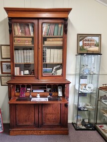
Furniture - Secretaire with Bookcase - the Watson Family of Wodonga
This secretaire once stood proudly in the de Kerilleau homestead at Wodonga. The homestead had been built for William Huon, son of the early pastoralist Paul Huon, in 1870 and named after the family's ancestral estate in France. The original lease of the Wodonga Run was granted to Paul Huon as No. 202 on 7th February 1837, about a year after his cousin Charles Huon had squatted on the land. Kenneth Darnton Watson bought de Kerilleau homestead in 1922 where the Watson family lived for three generations, caring for the land and serving the Wodonga community. Kenneth, his son Ian Darnton Watson and his grandson John Kenneth Darnton Watson all served on the Wodonga Council. John Kenneth Darnton Watson was born on 28 August 1960 in Wodonga. After completing his primary schooling locally, he boarded at Geelong College from 1973. John joined the rowing crews, starting in the 8th VIII crew and reaching the 1st VIII crew in 1978. He received multiple House colours awards for cross country, athletics and rowing and received School colours for rowing. On completion of his schooling, John spent some time jackarooing before studying farm management at Marcus Oldham College. He then returned home to de Kerilleau, Wodonga to manage the family property. In 1984 John married Christine Honybun, daughter of David Lewis Honybun and Marian Josephine Edkins. John and Christine had three sons. John was community minded and involved in a number of local organisations such as Apex and agricultural societies. He was elected to Wodonga City Council in 1997, serving until 2004. Due to increased pressure on available land to cater for the growth of Wodonga, some of the property was sold and in 2003 John donated 200 ha of Huon Hill ‘s western slopes to the City of Wodonga. After this time, he moved away from farming to become a Hungry Jack's franchisee. In 2009, the hard decision was made to sell de Kerilleau and John and his family moved into Wodonga. After sadly losing Christine to cancer in 2017, John became a member and Deputy Chairperson of the Albury Wodonga Regional Cancer Centre Trust Fund Board and Ambassador for the Sunshine Walk. Tragically after his own cancer battle, John Kenneth Darnton Watson passed away on 24 August 2023, aged 62 years following a life of service to the Wodonga community.This item is significant because it was owned by a prominent Wodonga family and came from a Historic Homestead in WodongaA secretaire with bookcase made of cedar. The bottom section has two cupboards with shelves. These doors support the desk when it is fully opened. Above this section is one large drawer, the front of which opens by pressing a small internal button on each side. The open drawer reveals a desk with a leather writing mat and several compartments. The desk is topped by a book shelf with 3 adjustable shelves. It has lockable glass doors.watson family wodonga, de kerilleau homestead, john watson -
 Wodonga & District Historical Society Inc
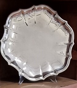
Decorative object - Silver Tray from John Kenneth Darnton Watson, Wodonga
This silver tray was donated by the family of John Watson and was used when they lived in de Kerilleau Homestead for three generations. de Kerilleau Homestead was built for William Huon, son of the early pastoralist Paul Huon, in 1870 and named after the family's ancestral estate in France. The original lease of the Wodonga Run was granted to Paul Huon as No. 202 on 7th February 1837, about a year after his cousin Charles Huon had squatted on the land. Kenneth Darnton Watson bought de Kerilleau homestead in 1922 where the Watson family lived for three generations, caring for the land and serving the Wodonga community. Kenneth, his son Ian Darnton Watson and his grandson John Kenneth Darnton Watson all served on the Wodonga Council. John Kenneth Darnton Watson was born on 28 August 1960 in Wodonga. After completing his primary schooling locally, he boarded at Geelong College from 1973. John joined the rowing crews, starting in the 8th VIII crew and reaching the 1st VIII crew in 1978. He received multiple House colours awards for cross country, athletics and rowing and received School colours for rowing. On completion of his schooling, John spent some time jackarooing before studying farm management at Marcus Oldham College in Geelong, Victoria. He then returned home to de Kerilleau, Wodonga to manage the family property. In 1984 John married Christine Honybun, daughter of David Lewis Honybun and Marian Josephine Edkins. John and Christine had three sons. John was community minded and involved in a number of local organisations such as Apex and agricultural societies. He was elected to Wodonga City Council in 1997, serving until 2004. Due to increased pressure on available land to cater for the growth of Wodonga, some of the property was sold and in 2003 John donated 200 ha of Huon Hill‘s western slopes to the City of Wodonga. After this time, he moved away from farming to become a Hungry Jack's franchisee. In 2009, the hard decision was made to sell de Kerilleau and John and his family moved into Wodonga. After sadly losing Christine to cancer in 2017, John became a member and Deputy Chairperson of the Albury Wodonga Regional Cancer Centre Trust Fund Board and Ambassador for the Sunshine Walk. Tragically after his own cancer battle, John Kenneth Darnton Watson passed away on 24 August 2023, aged 62 years following a life of service to the Wodonga community.This item is significant because it was owned by a prominent Wodonga family and came from a Historic Homestead in WodongaA circular silver tray with an embossed design around the outer edge.watson family wodonga, de kerilleau homestead, john watson, peter charlesworth -
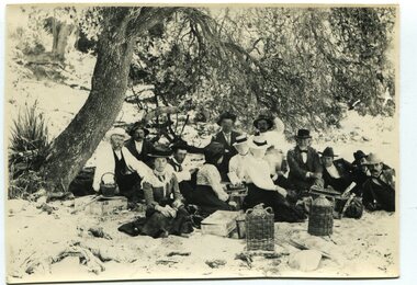 Orbost & District Historical Society
black and white photograph, January 1, 1897
This photograph shows Mr John Bird ( 3rd from left) ; Mr John Gilbert and Mr Lance Herbert among others having a picnic at the popular beach paddock at Old Station, Corringle, on January 1, 1897. Late in 1857 Mr Thomas T. Stirling took over Corringle Run ("Corringle" means "shallow water"). Mr Stirling and his family came from the wester district - Winchelsea. He settled at the Old Station. A few people were employed at the Orbost Stationb and there was settlement on the Orbost flats, Mr T. T. Stirling held the land from Lake Tyrers to Bemm River as a cattle run. About 1888 he became Secretary of the new Tambo Shire.This photograph is a portrait of rural life in the late 19th century. It is an insight into the dress, manners and activities of the first settlers of Orbost.Two copies of a black / white photograph of a group of men and women picnicking on the sand under tall trees.on back - "Beach Paddock - Old Station -1897" with a list of namesold-station-orbost rural-family-life