Showing 536 items
matching centre avenue
-
 Ballarat Clarendon College
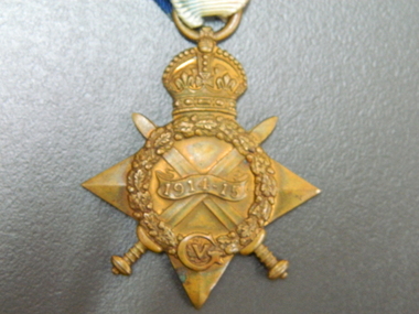
Medal, 1914-15 Star
The 1914–15 Star was authorised in 1918 and was awarded for service in specified theatres of war between 5 August 1914 and 31 December 1915. A recipient of the 1914 Star could not also be awarded the 1914–15 Star. Albert was born 29 June 1897 at his home 'Ashford Vale" farm, Cuthbert's Road, Cardigan. Albert, a second generation Australian, was the fourth son and sixth of eleven children born to dairy farmer John White and his wife Elizabeth, nee Douglas. Albert attended Bunker's Hill State School prior to enrolling at Ballarat College. After College he obtained employment with the engineering firm Ronaldson and Tippett in Ballarat. Following his eighteenth birthday Albert enlisted in the AIF in Ballarat with the rank of Private, No 2012. He embarked for the Middle East with 23rd Battalion on 26 August 1915 and was 'taken on strength at the Gallipoli Peninsular 25 October 1915". On 10 January 1916 Albert was posted to Alexandria, Egypt and during this time he was able to meet with his aunt Rose Douglas, an Australian Army Nursing Sister. This was a great comfort to his family. Albert was sent to France 19 March 1916 and transferred to the 22nd Battalion. He was mentioned in dispatches for 'good and gallant conduct' 5 August (1917?). Albert was hospitalised 30 March 1918, rejoined 22nd Battalion 3 June 1918, wounded in action 3 October 1918 but died of wounds at Rouen 10 October 1918. news of his death was received by his family in Australia just prior to the armistice. Albert Telfer White's sacrifice is commemorated at Ballarat College, Avenue of Honour Ballarat (Tree 1214), Ballarat Shire Honour Avenue Learmonth (Tree 163) and the Australian War Memorial Canberra. (These notes provided by family November 2016)Part of a greater A T White CollectionThe 1914-15 Star is a four pointed star of bright bronze, ensigned with a crown. The obverse has crossed gladius, overlaid with an oak wreath that is ensigned with the cypher of King George V. A scroll bearing the legend 1914-15 is centrally placed across the crossed blades. The 1914-15 Star ribbon has the red white and blue colours of the Empire, in shaded and watered stripes.Engraved on a scroll in the centre of the medal front: '1914-15' The oak wreath is ensigned with the cypher of King George V. The back of the medal is engraved: 2012 / Pte A T White / 23/BN. A.I.F. albert-telfer-white, medal, world war one, 1914-15 star -
 Federation University Historical Collection
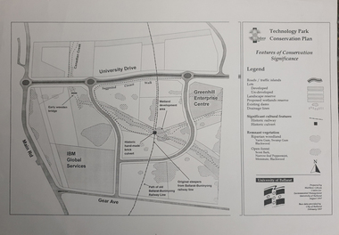
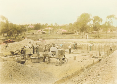
Map, Matthew Cibson, University of Ballarat Centre for Environmental Management, Ballarat Technology Park Conservation Plan, 1997, 02/1997
The Ballarat Technology Park is on the Federation University Mount Helen CampusMap showing the Ballarat Technlogy Camp, Greenhill Enterprise Centre, Canadian Wetlands. hand-made brick culvert sleepers, Ballarat-Buninyong Railway Line, IBM Global Services, early wooden bridge, Canadian Creek, Gear Avenue. ballarat technology park, canadian wetlands, greenhill enterprise centre, brick cultert, railway, ballarat-buninyong railway -
 Phillip Island and District Historical Society Inc.
Photographs, 30/11/2009
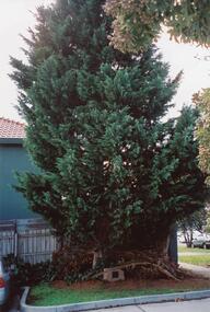
This is a collection of 12 coloured photographs of the Warley Hospital and Nursing home donated by Meg Davis. In 1923 the Warley Hospital was established in a house purchased by Mr Thompson. The new hospital was built in 1962 and the Nursing Home Annex was added in the mid 1970's. The Hospital was closed January 31st 2008.Colour Photograph 1 Cyprus Tree in grounds of the Warley Hospital with Plaque mounted on Granite plinth at base. Colour Photograph 2 Warley Avenue Cowes, Phillip Island with trees lining the street. Colour Photograph 3 Plaque mounted on Granite plinth stating "This tree was planted at the Diamond Jubilee Celebration 4-12-1983 by Mr Peter J Berwick, President Victorian Bush Nursing Association" Colour Photograph 4 Warley Avenue Street Sign mounted on concrete pole. Colour Photograph 5 Warley Hospital driveway alongside front entrance. Colour Photograph 6 Warley Hospital with "Expressions of Interest" Sign in foreground with SOLD across the sign. Colour Photograph 7 Warley Hospital Nursing Home. Colour Photograph 8 Warley Hospital front view with garage underneath. Colour Photograph 9 Warley Hospital Nursing Home. Colour Photograph 10 Warley Hospital front close up view of garage entrance and Nursing home to the right in the background. Colour Photograph 11 Warley Hospital Main Entrance. Colour Photograph 12 Warley Hospital original Medical Centre - now Consulting Rooms. warley hospital cowes phillip island, hospitals, warley nursing home cowes phillip island, warley avenue cowes phillip island, meg davis -
 Phillip Island and District Historical Society Inc.
Photograph, 23/04/1925
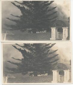
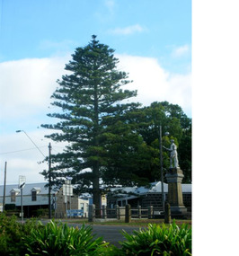
Photographs taken by Jessie "girlie" Smith of San Remo who owned The Penguin Cafe in Thompson Avenue. Norfolk Pine believed to have been planted by Baron Ferdinand von Mueller approx. 1863.Two black & white photographs of the scene during fire at Isle of wight Hotel 23/4/1925. Gateways left and right. Norfolk Pine in the centre. Smoke billowing behind.Post Cardphillip island, isle of wight hotel fire, jessie smith, norfolk pine, baron ferdinand von mueller -
 Phillip Island and District Historical Society Inc.
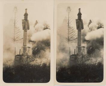
Photograph, 23/04/1925
Photographs taken by Jessie "Girlie" Smith of San Remo who owned the Penguin Cafe in Thompson Avenue, Cowes. Isle of Wight Hotel was built in 1870.Two photographs of the scene during fire at Isle of Wight Hotel 23/4/1925. Tall chimney and tank in centre. Smoke behind.Post Cardphillip island, isle of wight hotel fire, jessie smith -
 Mortlake and District Historical Society
The Peace Tree
This Norfolk Island pine tree was planted in 1919 as 'The Peace Tree'. A community gesture signifying the embrace of 'peace' as a valuable concept symbolised by the planting of a tree. [from Mortlake Dispatch] PEACE DAY 1919. Throughout the Empire three days were marked as Public Holidays including Peace Day in July 1919. Mortlake observed Peace Day by Peace Medals being distributed at the State School, Union Jacks being flown from many buildings and houses and the Peace Tree being planted at the intersection of Officer Street, Jamieson Avenue and Shaw Street. Then followed a procession [of local people]. It is assumed the Progress Association, which undertook the Avenue of Honour, also was responsible for planting the Peace Tree. Norfolk Pine tree located on eastern corner of Officer Street, Shaw Street and Jamieson Avenue intersection.1919, peace, norfolk island pine -
 Greensborough Historical Society
Map, Melbourne and Metropolitan Board of Works. Survey Division, MMBW, Yarra 2500 / 12.20. Watsonia Railway Station and environs, 1983_03
Melbourne and Metropolitan Board of Works. Yarra 2500 [base map]. 12-20, Parishes of Keelbundora 2856, Municipalities of Diamond Valley 257 and 228. Shows street names, easement sizes, lot numbers, lodged plan numbers, names of prominent features, contour values, creek or river names. Watsonia Railway Station and environs. Prominent streets: Watsonia Road, Elder Street, Morwell Avenue and Nepean Street. Includes former Watsonia Technical School and Gresswell Rehabilitation Centre sites.MMBW Map in 1:2500 [scale] series. Cream parchment with green tape reinforcing on edges and punched holes on left edge.mmbw, melbourne and metropolitan board of works, shire of diamond valley, watsonia - maps -
 Greensborough Historical Society
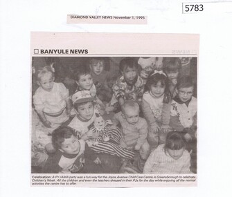
Newspaper Clipping, Diamond Valley News, Banyule News: Joyce Avenue Child Care Centre, 01/11/1995
... Banyule News: Joyce Avenue Child Care Centre...joyce avenue child care centre greensborough...The Joyce Avenue Child Care Centre in Greensborough... Plenty Lower Plenty melbourne The Joyce Avenue Child Care Centre ...The Joyce Avenue Child Care Centre in Greensborough celebrated Children's Week with a pyjama party.Newspaper clipping, black and white text and image.joyce avenue child care centre greensborough -
 Greensborough Historical Society
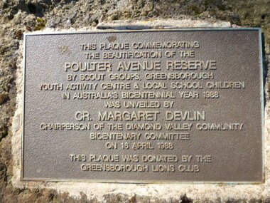
Photograph - Digital image, Plaque - Poulter Avenue Reserve Greensborough, 18/04/1988
Photograph of Plaque located in Greensborough's Poulter Avenue Reserve. The inscription reads: "This plaque commemorating the beautification of the Poulter Avenue Reserve by scout groups, Greensborough Youth Activity Centre & local school children in Australia's Bicentennial year 1988 was unveiled by Cr. Margaret Devlin chairperson of the Diamond Valley Community Bicentenary Committee on 18 April 1988. This plaque was donated by the Greensborough Lions Club" Digital copy of colour photograph.poulter avenue reserve greensborough -
 Greensborough Historical Society
Photograph - Digital image, Marilyn Smith, Old Ely House in Greensborough 2010, 03/07/2010
Recent photograph of one of the older houses in Greensborough. This house is in Grimshaw Street Photo taken at the very beginning of the construction of the Watermarc precinct. This house at 49 Grimshaw Street, along with the one next door at 47 Grimshaw Street were built by John Ely, son of Frederick Ely. John and his wife Melinda(Iredale), lived in Main Street (where is father Fred lived), then Grimshaw Street, John a labourer, later an assistant. John owned land in Grimshaw Street, where he built their home, he subdivided the land, this was when Eldale Avenue came to be, a combination of John’s and Melinda’s surnames. He sold a block of land, to Dr. E.R. Cordner, this is where the Cordner house, “Ashmead” was built. John and Melinda’s house later (mid 1970's) became a 'Ely House Medical Centre' owned by Drs. Myerscough and Hugh T McDonald . Alan (John's son) and Maisie’s a Physiotherapy Centre. Later Drs Stephen Hanslow and Dr. Eastern operated the medical centre. The house at 47 Grimshaw Street was demolished in 2017.Digital copy of colour photograph.grimshaw street greensborough -
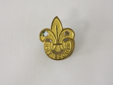 Kiewa Valley Historical Society
Badge Boy Scout, circa mid to late 1900's
This badge, which was used in the mid to late 1900's (Scouts started in Australia in 1909) clearly demonstrates that the families in the Kiewa Valley although slightly remote were still able to participate in one of the prime "boy" only social groups. The Boy Scouting movement brought together boys from all the socio-economic areas in the Australian population. The scouting group applied the concept of self sufficiency and friendship to all its membership. It was an avenue to cross the boundaries of distance and regional mores. Many of the boys in the Kiewa Valley and its regions would have been more "in tune" with the core principles of the scouting movement because being in a rural environment and "living on the land" was a day to day part of their life. What was an important aspect to they was the "mateship" and the belonging to a very large, and international, group of "like minded" boys. This avenue of interacting with a larger group of boys cut through the "small population" mores of a rural and at times isolated environment. This Boy Scouting activity was both mentally and physically significant to growing boys within the Kiewa Valley as it opened up the world to them.This brass badge has a front formed in a half circle base supporting a "Fleur de Leis" in a spear shape with "cut outs" at the appropriate places to provide the emphasis needed to project the form. Attached to the badge is a crescent moon shaped pronged frame for attaching the badge to lapels or collars or button eyelets. On the bottom scroll "BOY SCOUTS" and on the back type fastener "STOKES & SONS" below this "Melb".societies, boy scouts, apparel badges, numismatics badges -
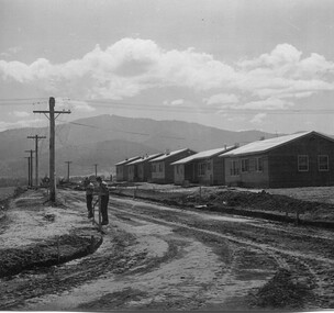
 Kiewa Valley Historical Society
Photo - Mount Beauty Houses circa 1947
A photo of Beauty Avenue houses looking south. A good example of the garden's created very early in Mount Beauty's history. Photo circa 1947These houses were built for the workers and their families during the construction phase of the Kiewa Hydro Electric Scheme by the State Electricity Commission of Victoria.Large coloured photograph with mountains in the background, houses,and SEC poles in the centre, and gardens in the foregroundOn the back in pencil 13411mount beauty housing, kiewa hydro electric scheme, mount beauty gardens, mount beauty township -
 Kiewa Valley Historical Society
Photo: Beauty Ave., Mt Beauty
Mt Beauty was built as a construction town by the S.E.C.V. for workers on the K.H.E.S.. Thee 5 houses in Beauty Ave were the first to be built.The power lines were already erected.Photo: Sepia photo of 5 new houses built at Mt Beauty on the higher side of Beauty Avenue.mt beauty township, beauty avenue -
 Kiewa Valley Historical Society
Photos - King Family Collection
The King family lived in Tawonga South where my older brother and sister went to school. We lived over the road from Wally Madison's farm. Later when a house became available, we moved into Valley Avenue, Mt Beauty. This is when I turned 5 and started my schooling. It was a long walk for a 5 year old as I remember. Then later we moved to 50 Lakeside Ave. I remember we loved living there as it was close to the school, footy ground and kindergarten. My father, Ted King, wad a carpenter and was involved in the building of many houses in Mt Beauty which was the home for the workers on the Kiewa Electric Scheme. So as they are part of the history of Mt Beauty I thought they may be useful to you as part of the history. The tennis photos, I vaguely remember Lou Hoad and Ken Rosewell giving exhibition matches in Mt Beauty. I may stand corrected on this, but I do remember my parents who were keen tennis players themselves were most excited at seeing these famous tennis players. As I was only 9 when we left Mt Beauty to live in Dimboola I still remember the shock of leaving a beautiful mountainous county side and arriving in a flat farming land next to a desert and seeing windmills One thing I do remember from school is, once a week (or fortnight) the teacher used to come around with a jar of little white pills, of which we were all to take. I really don't know what they were?? or for?? I also remember being taught to swim in the freezing cold river by a Mrs Smith who wore black bathers and wore her hair in a bun...... ...I am now in my 70s My father used to also carve intricate trays and jewellery boxes in his spare time. I think they were used for tennis trophies. by Diane Werner.x33 photos of small black and white photos of the Tawonga, Tawonga South and Mt Beauty - Photos not labelled but described as follows. See each photo for a possible label. A. Tawonga? B. Mt Beauty taken on the road to Bogong ? C. SEC Works D. Industrial buildings with mountains in the background E. Building site with wooden frame and 3 men F. Buildings with power poles G. Building site with lots of huts H. Buildings under construction I. Group of houses in the distance J. Group of houses in the distance K. Group of people in front of a building L. Group of 8 men sitting on timber planks, corrugated iron at back. M.& N. Building site with floor and upright timbers O. Mountain view with camp site in foreground P.& Q. Buiding site, several houses R.5 men at a building site S. portable building on trailer T & U. Mountain view V. Building site W. Group of men, car and mountains in background X. Cows Y. Pigs Z. 2 men standing next to cars. AA. Football players BB. Man painting a corrugated iron building CC. Football DD. Men in front of a building EE Buildings with mountains in background FF & GG Tennis payersHH & II. Electricity infrastructure -
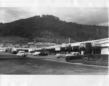 Kiewa Valley Historical Society
Photo - Kiewa Crescent Mt Beauty Circa 1960s
Mt Beauty was constructed by the SECV in the late 1940s. Built as a construction town for workers and their families during the construction of the Kiewa Hydro Electric Scheme. This photo shows the shops and cars in Kiewa St, Mt Beauty and the houses and Chalet in the background in the early 1960s.Large black and white photo taken from Lakeside Avenue end near the Post Office and looking towards the Chalet and Mt Beauty hill.Stamp in purple: "Please quote / No. LH1399 / when ordering / Laurie Richards / JW 1528"mt beauty township, kiewa st mt beauty, shops and cars in the 1960s mt beauty. -
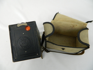 Kiewa Valley Historical Society
Bag Camera, circa 1920s
This item was manufactured in a period where the cheapest containers for portable equipment was canvas. The market place for cheap cameras was still restricted to European, England and its colonies. It was well before the post World War II explosion of the Asian manufacturing juggernaut.This item shows one of the most popular avenues of not only bringing new "modern" age equipment into the Kiewa Valley but also providing the local market with actual overseas inexpensive merchandise. It was a time when the new European fashion and "new age" equipment took years to permeate into regional Australia. The world, through Australia eyes, was still a very large planet and supply of "modern" lifestyle equipment emphasised the geographic isolation of Australia. Post World War II emigrants and an increasing flow of tourists to Australia provided the contact needed by rural settlements to open up not only their social contacts but lifestyle activities.Canvas, yellow, cream in color and with a weave pattern on the external side. It has stitched brown laminated fabric boarders containing all ends and corners. A flap opening top fastened on one side by a large press stud (15mm). A brown coloured leather carry strap (adjustable and 10mm wide) fasted at either of the longitudinal ends of the bag.camera, case photography, hobby, personal equipment -
 Kiewa Valley Historical Society
Camera Tele Ektra, Circa 1970s to 1980s
From the 1970's onward the relative isolation of regional areas was improving in "leaps and bounds". Social amenities, and life styles were changing at a great rate. Items such as this camera (recreational/life style/non professional) capture of the altering socio economic balance of rural based activities provided the catalyst for greater appreciation by city dwellers to the benefits of rural life. The greater levels of communicative avenues, especially the visual (photography, pictures, television and the internet), from the beginning of this period and throughout the time frame (1970 to the 2000s) has cut the major restraints of what was rural "isolationism".The significance of this type of camera, being a small two lens (normal, telescopic) and portable piece of equipment, allowed non professional tourists, locals or visitors to visually display the uniqueness of the Kiewa Valley and Alpine regions. This method of promotional and intimate visual reproduction of not only physical but also through personal involvement, of the photographer to the audience, a greater psychological impact, by the nature of intimacy involved. This type of photography is one of the most effective stimuli to promote the unique qualities of the Kiewa Valley region.This Item is dual lens (22mm,44mm) camera comprising of an elongated oblong shape, black hard plastic shell. It has a slightly rough surface(for a better fingers grip), two latches are located at the back, one to release the camera from its hinged protective cover and one to move to the next picture frame (film is within a cartridge).On swing cover "Kodak Tele 1 " on back in small print "MADE IN USA" On camera body "KODAK TELE EKTRA 1" underneath "CAMERA" and on slide switch(front) to change lenses:"Tele" and "Norm" kodak two lens camera, photographic hobby usa made camera -
 Eltham District Historical Society Inc
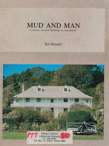
Book, Earthbuild, Mud and Man: a history of earth buildings in Australia by Ted Howard, 1992
Includes references to local sites Bear's Castle, Yan Yean (City of Whitlesea), mud brick houses in Eltham, including at Montsalvat and Eltham Community Centre, Smith's Gully, Plenty Baptist Church and Warrandyte. Includes chapter on Alistair Knox. The author's own home appears in the book on page 100. It was situated at Batman Road, Eltham next to the manse and church opposite Stanley Avenue. It was demolished for unit development June 2004 after the author's death in 2003. A significant and oft cited history of the mud brick earth construction style of architecture which includes a number of examples within the Shire of Nillumbik, known to be a site of the environmental earth building movement following WW2.198 p. : ill. (some col.), maps ISBN 0646069624earth construction, mud bricks, pise, domestic architecture -
 Eltham District Historical Society Inc
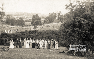
Postcard - Photograph postcard, Boxing Day, Eltham, 26 Dec 1912
Postcard inscribed on reverse "Eltham 26.12.12" In the distance on the hill to the left of centre is the new St Mary's Catholic Church, corner of Main Road and Henry Street, Eltham (blessed 13 October 1912, later destroyed by fire in 1961). Just below the church, Shillinglaw Cottage is visible with two of the Shillinglaw trees partially obscuring the church. Photograph believed to have been taken just west of the present-day Catholic Ladies College carpark in the Inez Avenue Park region with Diamond Street running up hill behind the fence in middle of picture.Digital file only Postcards scanned from the collection of Michael Aitken on loan to EDHS, 13 Feb 2018michael aitken collection, postcards, eltham, picnic, catholic church, exhibition yprl 2019-12, shillinglaw cottage, shillinglaw trees, summer -
 Ringwood and District Historical Society
Document - Correspondence files, Ringwood Pre-School Parents Club, Ringwood Pre-School Parents Club: correspondence. 1946-1970, 1946-1970
Collection of papers of the Ringwood Pre-School Parents Club of the Greenwood Avenue Kindergarten, known also as Greenwood Avenue Pre-School. 4605.1 - Correspondence 1946-1954 4605.2 - Correspondence 1955-1959 4605.3 - 1 cash receipt book, 2 memo books 1962 4605.4 - 7 receipt books containing enrolments 1958-1965 4605.5 - Secretary's Annual Report, July 1963 (2 copies) 4605.6 - To E.V. Pullin from State Film Centre - information films - Child Development Series 4605.7 - General receipts 1960-1961 including 3 used cheque books and National Bank statements 4605.8 - Receipts, 3 used cheque books, memo book, National Bank statements 1961-1962 4605.9 - Receipts 1962-1963 4605.10 - Receipts 1963-1964 4605.11 - Correspondence 1960-1961 4605.12 - Silver Jubilee correspondence 1970, invitation signed by E.V. Pullin (Life Member), acceptances and non acceptances. -
 Ringwood and District Historical Society
Pamphlet, Land Sale Brochure Titled Eureka Plan Book - Seven Delightful & Valuable Ringwood Estates - circa 1925
Twenty page land sale brochure including photographs, subdivision features and local facilities. Additional flyer with conditions of sale and prices for estate blocks.Seven delightful and valuable Ringwood Estates called Bestpart, Paradise, Hill Top, Greenwood, Creek, Station, and School Estates. These nestle amidst the hills and valleys of beautiful Ringwood district. Also Goodluck Estate at Clarinda. Pamphlet marked as being From Mr. Farmer, No. 5 Flinders Court, Melbourne. Phone 988, 989 Central, or 55 Ringwood after 7 p.m. Plan of Ringwood School Estate includes William Street (later Kendall Street), Greenwood Avenue, Alton Street and Locke Street. Plan of Bestpart Estate, Ringwood, includes Bedford Road, Wilana Street, Greenwood Avenue, Caroline Street, Henry Street and Haig Street. Plan of Ringwood Station Estate includes Pitt Street, Bedford Road, Greenwood Avenue, Station Street, William Street (later Kendall Street, James Street, Wantirna Road, Caroline Street, Henry Street, Ellison Street and Haig Street. Plan of Geenwood Estate, Ringwood, includes Prussian Road (later Geenwood Avenue). Plan of Paradise Estate, Ringwood, includes Canterbury Road, Dandenong Road (Wantirna Road), Luck Street and Paradise Road. Plan of Creek Estate, Ringwood, includes Dandenong Creek, Wantirna Road and Gordon Crescent. Plan of Hill Top Estate, Ringwood (later Heathmont area), includes Heathmont Railway Station, Heathmont Road, Balfour Avenue, Lilian Street, Edith Street, Edna Street and Great Ryrie Street. Plan of Goodluck Estate, Clarinda, includes Talbot Avenue, Good Street, Luck Street, and Centre Road in locality plan between Oakleigh and Clayton Railway Stations. -
 Ringwood and District Historical Society
Flyer, Stillwell & Stephens Pty. Ltd, Brochure - Multiple Properties for Public Auction at Box Hill, Ringwood, Wonga Park and Clarinda - 28th November, 1934
Seven-page brochure advertising Mortgagees' Realising Sale by Public Auction on Wednesday, 28th November, 1934 for properties at Box Hill, Ringwood, Wonga Park, and Clarinda (via Oakleigh), including photographs, property descriptions, and terms of sale.Auction Commencing at 2.15 p.m. in the Orient Line Auction Rooms, 352 Collins Street, Melbourne. Solicitors: Messrs. Madden, Butler, Elder & Graham, 406 Collins Street, Melbourne. (Agents) H.P. Knight & Co. Property Salesmen and Subidivisional Experts, 315 Collins Street, Melbourne, 'Phones: Central 10615, 10616. Attractive Residential, Orchard, and Market Garden Properties, and Public Hall and School Rooms. 1. Wonga Park via Ringwood - "Holme Bush" off Warrandyte Road, Part of Lots 14 and 15, Ringwood Orchard Estate, approximatgely three miles (north) of Ringwood Railway Station - 64 Acres. 2. 17 Bishop Street, Box Hill - timber residence. 3. Greenwood Avenue, Ringwood - On East Side, 150 feet 3 inches South of Bedford Road - timber attic residence. 4. Ringwood - Wantirna Road, South-east corner of Canterbury Road - Orchard Property of approx. 11-1/2 Acres. 5. Box Hill - Whitehorse Road, South-east corner of Linsley Street - Timber building utilised as a Public Hall and Private School. 6. Clarinda vic Oakleigh, Talbot Crescent, off Centre Road - Home on 10 acres of land. -
 Ringwood and District Historical Society
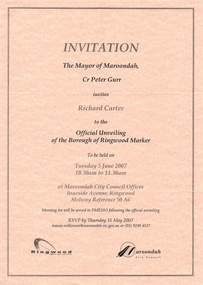
Souvenir - Mayoral Invitations, Unveiling of Borough of Ringwood Marker, 2007
Folder with two A4 invitations to unveiling ceremony and morning tea at Maroondah City Council Offices, Braeside Avenue, Ringwood, Victoria, Tuesday 5 June, 2007, showing logos of Maroondah Council and Ringwood Historical Society, co-organisers. Folder also includes Mayoress' Luncheon inviation on 23 July, 2007, at Karralyka Centre. -
 Ringwood and District Historical Society
Photograph, Construction of Ringwood baths, Miles Avenue. Construction began in January 1934 and the pool was officially opened in November that year
Coloured photograph. Photograph taken by "Mervyne" Ringwood Studios."Written on back of photograph" Ringwood baths under construction. Photo taken from corner of Ringwood St & Miles Ave. Houses just above baths are in Reynolds Ave & top left in Warrandyte Road. Top centre- corner Warrandyte Road & Woodside Ave. White railing centre right is on the bridge across Mullum Creek. Adelaide St ran from Maroondah Highway to Reynolds Ave. Bridge later washed away- 1931. -
 Ringwood and District Historical Society
Photograph, Croydon West High School off Cutts Avenue and Maroondah Hwy, Ringwood - November, 1969
Written on backing sheet, "West Croydon School (In Ringwood municipality)". November 1969. The area behind the pine trees was used as a training ground by the Wilhelmina Soccer Club, later called Ringwood City SC and Ringwood FC. It was later sub-divided and the two streets named Wilhelmina and Juliana Courts, in honor of Wilhelmina, Queen of the Netherlands, and her daughter, Juliana, later succeeding her as Queen. The Burnt Bridge Shopping Centre can be seen in the far west on one of the images. -
 Ringwood and District Historical Society
Photograph, View from Herman Pump's orchard, Heathmont near Royal Avenue. Looking towards Bedford Rd. and Ringwood (undated)
Typed below photograph, "View from Herman Pump's orchard, Heathmont near Royal Avenue. Looking towards Bedford Rd. and Ringwood. Loughnans Hill in background to left of centre." -
Glen Eira Historical Society
Document - SWIMMING POOLS
This file contains eight items pertaining to Caulfield’s swimming pools: 1/Report entitled ‘Future Options in the Provision of Public Swimming Facilities in the City of Caulfield’, dated March, 1983, prepared by Caulfield Planning Department of approx. 50 pages. 2/Photocopy of an article from ‘Port Phillip/Caulfield Leader’, dated 11/02/2002, concerning the cost of pool maintenance. 3/Public consultation paper entitled ‘Pools Past, Present and Future’, dated 07/03/2006, prepared by Glen Eira City Council, of 24 pages. 4/Article dated 08/03/2006 from ‘The Age’ concerning Glen Eira Residents’ fight to save swimming pools in Glen Eira. 5/Two page printed leaflet entitled ‘Save Our Pools’ dated 18/03/2006 produced by the northern memorial action group. 6/Three page printed survey sheet entitled ‘The East Bentleigh Swim Centre; an assessment of community needs’ undated, with accompanying return envelope. 7/Front page article from the ‘Glen Eira Caulfield Leader’ dated 04/04/2006 entitled ‘Save Our Pools’. 8/An article from ‘Port Phillip/Caulfield Leader’ dated 04/04/2006, concerning a former Glen Eira Council employee’s information about the Council’s pools report and a ‘letter to the editor’ by Sue Litchfield of Elsternwick containing her view of Glen Eira’s pool requirements.city of caulfield, caulfield, glen eira, caulfield planning department, palmer david, caulfield memorial pool, erlich noel, newton andrew, bentleigh east swim centre, city of glen eira, glen eira town hall, carnegie library, carnegie, shepparson avenue, mckinnon secondary college, east boundary road, koornang road, east bentleigh, feldman david, northern memorial pool, centre road, bentleigh, hudson rob, magee jim, antoine marc, swimming pools, olympic pools, public baths, baths, memorials, local government, northern memorial action group, community groups -
Glen Eira Historical Society
Letter - Rosstown Railway
This file contains four items: 1/A black and white photocopy of a letter dated either 07/08/1889 or 09/08/1889, from Robert Lundon to an unidentified recipient discussing an agreement reached between the author – on behalf of the recipient – and Soon Hang Hi in regard, in regards to the allotment known as Webber’s. The agreement is outlined in the letter in what appears to be Chinese characters, and includes the marks of Robert Lundon and Soon Hang Hi. File note from Joy Wu states that the calligraphy is not Mandarin or traditional Chinese. 2/Three sheets of hand-written working notes with information taken from the Victorian Government Gazette on THE ROSSTOWN AND MURRUMBEENA LAND COMPANY LIMITED, THE ROSSTOWN JUNCTION RAILWAY AND PROSPERITY COMPANY LIOMITED, and THE ROSSTOWN JUNCTION, ELSTERNWICK, AND OAKLEIGH RAILWAY COMPANY LIMITED, covering dates between 1887 and 1894. The notes concern meetings and creditors claims relevant to the companies, with reference numbers for the information source. Date and author of the notes are not recorded. 3/A black and white photocopy of the a partial map of the Rosstown Railway and surrounding area, undated. The map includes the names of landholders in the areas of Brighton, Garden Vale and Elsternwick, as well as other railway lines present in the region. 4/A fold-out map and guide of the Rosstown Rail Trail, including a brief general history of Caulfield as well as a more extensive biography of William Murray Ross and the Rosstown Railway. The map marks and describes significant sites along the trail, including photographs of some of these sites, provided by DF Jowett.documents, correspondence, webber’s, lundon robert, chinese characters, ethnic communities, signatures, text, settlements, taxes, fraser john grieves, lovell r.h., price davies, meetings, communication activities, soon hang hi, commercial events and activities, the rosstown and murrumbeena land company limited, victorian government gazette, bulmer richard, parry john, osment henry, shareholders, creditors claims, the rosstown junction railway and property company limited, finch and best, lawyers, the rosstown junction elsternwick and oakleigh railway company limited, cameron w.c., phillips p.d., garden vale, elsternwick, elsternwick railway station, rosstown, rosstown railway, thomas street, bay street, kooyong road, melbourne and brighton railway, hawthorn road, bambra road, caulfield and frankston railway, booran road, grange road, koornang road, murrumbeena road, north road, north road railway station, east brighton railway station, south road, railway routes, railway lines, railways, land transport, murphy j., caulfield, hamilton t.f., dane p., holloway, webb, ailee john, payne t.b., brodie chas, dane john, o’neil h., mccombie john, mcmillane a., smyth c.d., cooper, ebden, landholders, jeffrey j.d., gill j., balcombe a.e., cooper h., mcnab j., white j., sutherland j., greeves a.f.a., newton m.c., chamley f.b., fowler j., inglis p., grant t., stooke j., swanson g., cochrane c., adams e.b., mccombie thas, keyes robert, brighton cemetery, burials grounds and graveyards, war-ein road, were j.b., holland j., mcmahon c., winter t.l.m., dendy henry, mitchell w., jackson s., were j.e., wickham francis dawe, bryant jane, east brighton railway station, railway stations, maps, allotments, land titles, roads and streets, rosstown rail trail, city of glen eira, tourism, trains, tourism information bureaus, tours, pamphlets, elsternwick railway park, oakleigh junction, princes park, ee gunn reserve, packer park, sites, jowett d.f., weickhardt i.g., return to rosstown: railways land sales and sugar beet ventures in caulfield, land sales, walking trails, ross william murray, transport objects, locomotion, walking, cycling, driving, sports, country mansions, people, caulfield john, builders, construction and demolition workers, occupations, careers, professionals, topography, geology, landforms, horticulture, market gardens, primary industry workers, city of caulfield, mood kee, pennington harold, annual general meetings, caulfield town hall, glen eira city council, carnegie, carnegie station, rosstown station, people by circumstance, migrants, sugar beet, sugar beet mill, sugar beet industry, mills, factories, sea beach lines, bent thomas, parliamentary representatives, neville street, miller street, lemann’s swamp reserve, koornang park, cane sugar industry, breweries, rabbit processing plants, health establishments, hospitals, food production establishments, abattoirs, thieves, social problems, vagrants, theft, squatting, financial economics, debt, finance industry, insurance companies, company managers, bentleigh, ross leila, the grange, leila road, wild cherry road, financial trouble, mortgages, gisborne street, archibald street, riddell parade, victoria railways, glen huntly road, clarence street, college street, gladstone parade, parrell street, aileen avenue, seaview street, drion estate, land subdivisions, dover street, sussex street, landfill, marara road, booran road, woodville avenue, dorothy avenue, ormond park, royal avenue, ormond railway station, oakleigh road, melten avenue, miller street, munro avenue, lord reserve, neerim road, toolambool road, the rosstown hotel, rosanna street, murrumbeena crescent, commercial establishments, the national bank, rosstown road, kangaroo road, poath road, freda street, hughesdale kindergarten, oakleigh council, hughesdale community centre, civic establishments, galbally reserve, plaques, warrigal road, out and about brochures -
 Glen Eira Historical Society
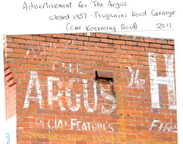
Photograph - CARNEGIE
24 photographs relating to Carnegie plus 1 slide: 1/Two photographs, one of Koornang Road c.1920’s and one of flower shop rear of library, date unknown. 2/One photograph of Carnegie Post Office c. undated. 3/Two photographs Koornang Road, Carnegie and phone boxes, Carnegie, dated 1914. 4/Two photographs (the same) of an RSL Ball dated 15/08/1937. 5/17 black and white negative photos – reprinted, date unknown, of Carnegie Library, shop front opening Koornang Road. 6/Slide showing Koornang Road, Carnegie looking South. 7/6 photocopied postcards from Valentines Real Photo Series, in album owned by Mrs. Zoe Mason, collected and returned to Pam Speedy (daughter) 12 Wattle Grove, East Malvern, 15/03/1999. Photocopied pages from 1923 Sands and McDougalls included with some prints to give an idea of architecture and other retail trade. 8/Two photocopied prints of Carnegie Flood. 1946 – Koornang Road, shows shopkeepers in street at that time. 9/Two photographs of brick wall advertising the "Argus" newpaper, which closed in 1957. Photos taken in 2011 when building was exposed prior to rebuilding on site.koornang road, rosstown road, carnegie, shepparson street, carnegie library, carnegie post office, mcallister b., glen huntly, glenhuntly, phone boxes, memorial hall, bamfield m., tranmere avenue, carnegie railway station, stations, libraries, post offices, memorial hall carnegie, progress hall, carnegie community singing, social clubs, chadstone progress, newspapers, temminghoff robert, carnegie chamber of commerce, caulfield city council, rob’s chocolate box, rosstown, ross william murray, rosstown railway, elsternwick, oakleigh, city of caulfield, glen huntly road, glenhuntly road, grange road, carnegie primary school, primary schools, murrumbeena, neerim road, dandenong road, koornang park, lord reserve, rosanna street reserve, packer oval reserve, caulfield swim centre, holywood grove, mile end road, mcpherson avenue, munster avenue, rosstown hotel, leila road, methodist church, toolambool street, carnegie theatre, carnegie estate agency – sims and broadbent, woorayl street, estate agents, cowie j. mrs., confectioner, woodhouse e., stationer, mckay jno. a., mckay jonathon, small goods, perry w. b., chemists, kinsman e. h., newsagents, jones a. w., mckee wm., furniture stores, neil geo. m., grocer, truganini road, brick -
Glen Eira Historical Society
Book - CAULFIELD CENTENARY 1957
This file contains four items 1/Two copies of a twenty-four page booklet titled CITY OF CAULFIELD CENTENARY 1857-1957, created by the Caulfield City Council and printed by Peter Isaacson Pty Limited, Melbourne. The booklet details important aspects of Caulfield’s history including council procedures, the Caulfield Road District Proclamation, the first election and a summary of 100 years of local government with a description of the present Caulfield in 1957. The booklet also includes several pictures of various Caulfield landmarks and people including one of Caulfield City Councillors (11 men and 1 woman). Also one photocopied version of this booklet. 2/Eleven pages of typed notes for the City of Caulfield Centenary booklet. All notes are undated and incomplete. Two pages titled NOTES on THE HISTORY and PROGRESS OF THE CITY OF CAULFIELD, author unknown. Three and a half pages titled THE STRUCTURE OF LOCAL GOVERNMENT IN VICTORIA, author unknown. Five pages titled 100 YEARS OF LOCAL GOVERNMENT – EARLY CAULFIELD, by Mrs A. P. Bell. 3/A typed letter to Miss V. Webb-Langdon from the Town Clerk H.G. Nelson, acknowledging her contribution to historical details for the Caulfield Council’s Centenary booklet, dated 24/12/1957. 4/A handwritten letter and a handwritten note regarding the acquisition of notes for the Caulfield Centenary booklet. The letter is dated 03/08/2006 and the note is dated 09/02/2007.city of caulfield centenary, caulfield road district, sinclair a.j.g., city hall, war memorials, gamble h.a., machin l.r., bunny f.c.d., caulfield park, koornang reserve, parton e.m., sims h.e., thomson w.r., gunn e.e., yorston j.s., wallace g.e. mrs, green w.c., jenner e.r., ward boundaries, dandenong road, queens avenue, normanby road, station street, bond street, glen eira road, orrong road, poath road, north road, booran road, nepean highway, glen huntly road, glenhuntly road, inkerman road, hotham street, nelson h.g., fullard w.r., mackley g.j., ellis k.i, crosbie m.r., nutting b.i., body j.h., pritchard r.j., guildford l.t.g., lund l.m., street h.c., reynolds a.w., elections , political processes, local government, springthorpe reserve, greenmeadows gardens, business and finance, roads and streets, caulfield racecourse, east caulfield reserve, mackinnon reserve, hawthorn road, balaclava road, murrumbeena road, lempriere avenue, victoria street, koornang road, lord reserve, lyons street, murrumbeena reserve, kangaroo road, ormond park, beatty crescent, foch street, packer reserve, oakleigh road, leila road, prices park, bambra road, riley reserve, playgrounds, town hall, maternal and child health centres, truganini road, grange road, senior citizens centre, barkley sir henry, moore david, handasyde gilbert, caulfield school room, harris g.w., semple john, dempsey william, brooks w.a., wilson thomas, lyall william, murrum murrumbeen lifestyle, ‘greenmeadows’ house, lempriere family, aboriginal culture, ‘rippon lea’ house, caulfield john, ‘slaney’s’ home, alma road, paddy’s swamp, racecourse hotel, caulfield technical college, bevan mr., ‘grosmont’, hart john, railways, mansions, ‘rosecraddock’, langdon h. j., caulfield cup, ‘crotonhurst’, webb judge, ‘kilwinning’, service james, ricketson henry, ‘glen eira’, house names, garden vale, ross william murray, ‘ross’s folly’, outer circle railway, caulfield grammar school, davies j. henry, lagdon william, grimwade f.s., loyd charles du plan, hope george, ‘airdrie’, kooyong hill, market gardens, dairies, lady talbot milk supply, jenner family, o’niell college, presentation sisters, glenferrie road, grimwade frederick sheppard, grimwade alice, ‘harlston’, grimwade house, ‘saint aubin’s’, ‘st. aubin’s’, ‘caulfield hall’, caulfield john p.t., st georges road, caulfield military hospital, nursing homes, health establishments, dover street, sports and recreations, rosanna street, ‘cantala’, health services, parks and reserves, community services, town planning, local government finance, local officials and employees