Showing 153 items matching "farmhouses"
-
![Photograph - Digital image, Willis Vale [2], 1950c](/media/collectors/4f729f5697f83e03086015b8/items/54fd41442162f10d30bf885f/item-media/54fd41912162f10d30bf8caa/item-fit-380x285.jpg) Greensborough Historical Society
Greensborough Historical SocietyPhotograph - Digital image, Willis Vale [2], 1950c
View of Greensborough in the distance from Willis Vale and surrounding land: House built by Edward Maygar, The flowering Hawthorne Bushes were planted by William Partington. Note the prominent house on upper right where Robert Whatmough lived in the mid 19th century and later sold to Partington family. It was located on the Plenty River across from Partington's Flat. The derelict Willis Vale house was destroyed in 1964 when a fire originating from North Plenty Gorge - Kurrak Road - was lit by two teenage boys and made its way several kilometres down to Partington's Flat Greensborough. In 1946, Alan Partington built the Alwyn Farmhouse in place of the original Robert Whatmough home seen in this photo which became Whatmough Park circa 1976.Home of the Partington familyDigital copy of black and white photograph.willis vale, partington family, maygar family, whatmough -
 Surrey Hills Historical Society Collection
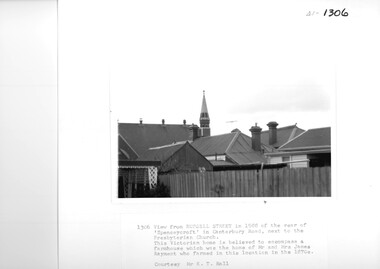
Photograph, View from Russell Street, of the rear 'Spencecroft' in 1988
Spenceycroft was home of James and Elizabeth Rayment, who had a dairy farm in the area in the 1870s. The house was located in Canterbury Road next to the Surrey Hills Presbyterian Church. For many years, it was hidden behind a large fence sheltering it from the noise of traffic along Canterbury Road. It has been claimed that it incorporated part of the original farmhouse built on the site by George Klepper, who planted a vineyard in the area. George’s family was one of a number of German families who settled in Surrey Hills during the later part of the 19th century. In recent years Spenceycroft was sold several times and became increasingly derelict. Since its last sale, it has been demolished. Some of the above may be in error. Research is currently being undertaken to authenticate claims previously asserted.A black and white photograph of the rear of some buildings from Russell Street, at the rear of 'Spencecroft'.house names, spenceycroft, spencecroft, russell street, surrey hills, james rayment, (mrs) elizabeth rayment -
 Surrey Hills Historical Society Collection
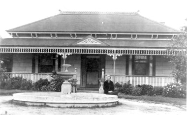
Photo, 'Spenceycroft', Canterbury Road
The photo is of ‘Spenceycroft’ at 654 Canterbury Road, Surrey Hills. For many years this home was hidden behind a large fence sheltering it from the noise of traffic along Canterbury Road, however it dates back to the very early days of settlement in the Surrey Hills area. Canterbury Road was then known as Delany’s Road. ‘Spenceycroft’ is thought to incorporate part of the original farmhouse built on the site by George Klepper, who planted a vineyard in the area. George’s family was one of a number of German families who settled in Surrey Hills during the later part of the 19th century. Later, the land associated with ‘Spenceycroft’ was worked as a dairy farm by James and Elizabeth Rayment. In recent years 'Spenceycroft' has been sold several times and has become increasingly derelict. Sold again in 2015 when it had become quite derelict, it was demolished and re-developed.A black & white photo of double-fronted Victorian style home with a fountain centre front and low foliage in front of the veranda. A woman is sitting by the fountain. 'spenceycroft', canterbury road, james rayment, elizabeth rayment, george klepper -
 Chelsea & District Historical Society Inc
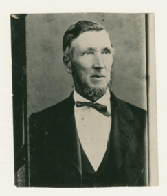
Photograph - Mr Hugh Brown, early 1900's
Hugh Brown (1830-1930), born in Ireland, arrived in Adelaide in 1855 and in the Mordialloc district in 1856. Mr Brown brought land in 1866 and built his farmhouse “Pine Vale” in 1870 near the site of the present Mordialloc Secondary College (then part of the property) and extended his property when the swampland was made open for selection in 1871. The property was a market garden and orchard. Hugh Brown married Zillah Baxter (1866) and they had six sons, five living to adulthood. The Brown family increased their land holding until they held a major part of the farmland between Mordialloc Creek to almost the Aspendale Railway Station. The property was a market garden and orchard. Mr Brown took an active interest in the public life of the community, a Justice of the Peace; Councillor of Dandenong Shire for over 30 years, was twice Shire President; and a founding member of the Mordialloc Mechanics Institute. Black and white photo of Mr Hugh Brown.hugh brown, mordialloc, pioneer, market gardener, farmer, pine vale -
 Southern Sherbrooke Historical Society Inc.
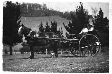
Photograph - Cissie Johns in jinker, c.1913
B&W photo shows Cissie Johns and another person who may be her brother Percy, sitting in a jinker. A dark horse with a white blaze is harnessed to the jinker. Cissie is seated nearest the camera. She is wearing a pale wide-brimmed hat and pale clothing. Her long fair hair is loose around her shoulders. The other person is holding the reins and is wearing a dark hat and pale shirt. This photo may have been taken at the same time as M0104. The subjects are facing south. The sun is shining. They are on a flat expanse of grass. Beyond them are several cypress trees. These are most likely part of the cypress hedges lining the driveway to Glen Park Farm farmhouse. In the background is the eastern flank of Black Hill. A small shed can be seen beside the driveway, partly obscured by the jinker's wheel. Dated c.1913. -
 Chelsea & District Historical Society Inc
Photograph - Zillah Brown, c 1860's
Zillah Brown (nee Baxter), was the wife of a pioneer of the district, Mr Hugh Brown. Hugh Brown (1830-1930), born in Ireland, arrived in Adelaide in 1855 and in the Mordialloc district in 1856. Mr Brown brought land in 1866 and built his farmhouse “Pine Vale” in 1870 near the site of the present Mordialloc Secondary College (then part of the property) and extended his property when the swampland was made open for selection in 1871. The property was a market garden and orchard. Hugh Brown married Zillah Baxter (1866) and they had six sons, five living to adulthood. The Brown family increased their land holding until they held a major part of the farmland between Mordialloc Creek to almost the Aspendale Railway Station. The property was a market garden and orchard. Mr Brown took an active interest in the public life of the community, a Justice of the Peace; Councillor of Dandenong Shire for over 30 years, was twice Shire President; and a founding member of the Mordialloc Mechanics Institute. Black and white studio photo of Mrs Zillah Brown and her son.University Studios 306 Lygon St. Carltonhugh brown, mordialloc, pioneer, zillah brown, zillah baxter, pine vale -
 Chelsea & District Historical Society Inc
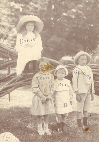
Photograph - The Brown Children, 1910
Doris, Alex, George and Jean are the grandchildren of Mr Hugh Brown. Hugh Brown (1830-1930), born in Ireland, arrived in Adelaide in 1855 and in the Mordialloc district in 1856. Mr Brown brought land in 1866 and built his farmhouse “Pine Vale” in 1870 near the site of the present Mordialloc Secondary College (then part of the property) and extended his property when the swampland was made open for selection in 1871. The property was a market garden and orchard. Hugh Brown married Zillah Baxter (1866) and they had six sons, five living to adulthood. The Brown family increased their land holding until they held a major part of the farmland between Mordialloc Creek to almost the Aspendale Railway Station. The property was a market garden and orchard. Mr Brown took an active interest in the public life of the community, a Justice of the Peace; Councillor of Dandenong Shire for over 30 years, was twice Shire President; and a founding member of the Mordialloc Mechanics Institute. Black and white studio photo of the Brown children standing on a tee-tree in Attenbourgh Park, Mordialloc.Doris, Alex, Jean, Georgehugh brown, mordialloc, jean brown, zillah brown, doris brown, alex brown, attenbourgh park -
 Chelsea & District Historical Society Inc
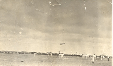
Photograph - Mr Hugh Brown's Farm, A game of cricket
A cricket game in the paddocks of Mr Hugh Brown farm. Hugh Brown (1830-1930), born in Ireland, arrived in Adelaide in 1855 and in the Mordialloc district in 1856. Mr Brown brought land in 1866 and built his farmhouse “Pine Vale” in 1870 near the site of the present Mordialloc Secondary College (then part of the property) and extended his property when the swampland was made open for selection in 1871. The property was a market garden and orchard. Hugh Brown married Zillah Baxter (1866) and they had six sons, five living to adulthood. The Brown family increased their land holding until they held a major part of the farmland between Mordialloc Creek to almost the Aspendale Railway Station. The property was a market garden and orchard. Mr Brown took an active interest in the public life of the community, a Justice of the Peace; Councillor of Dandenong Shire for over 30 years, was twice Shire President; and a founding member of the Mordialloc Mechanics Institute. Black and white studio photo of a cricket game in the paddock Mr Hugh Brown's farm. Farm houses and sheds in the background. A biplane flying overhead.hugh brown, mordialloc, pioneer, pine vale, farm, cricket, biplane, paddock, farm house -
 Chelsea & District Historical Society Inc
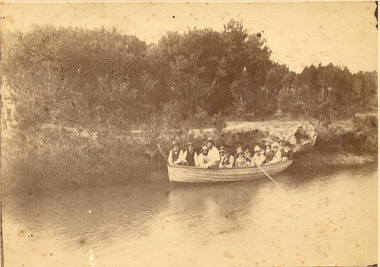
Photograph - The Brown Family, Boat Trip, 1882
The members of the Brown family in a rowing boat on Mordialloc Creek. Hugh Brown (1830-1930), born in Ireland, arrived in Adelaide in 1855 and in the Mordialloc district in 1856. Mr Brown brought land in 1866 and built his farmhouse “Pine Vale” in 1870 near the site of the present Mordialloc Secondary College (then part of the property) and extended his property when the swampland was made open for selection in 1871. The property was a market garden and orchard. Hugh Brown married Zillah Baxter (1866) and they had six sons, five living to adulthood. The Brown family increased their land holding until they held a major part of the farmland between Mordialloc Creek to almost the Aspendale Railway Station. The property was a market garden and orchard. Mr Brown took an active interest in the public life of the community, a Justice of the Peace; Councillor of Dandenong Shire for over 30 years, was twice Shire President; and a founding member of the Mordialloc Mechanics Institute. Sepia photo of a adults in a large rowing boat on Mordialloc Creek, Mordialloc.hugh brown, mordialloc, pioneer, pine vale, mordialloc creek, row boat -
 Chelsea & District Historical Society Inc
Photograph - Jean Brown, Highland Dress, 1924
Zillah Jean Brown, known as Jean, was the granddaughter of a pioneer of the district, Mr Hugh Brown. Hugh Brown (1830-1930), born in Ireland, arrived in Adelaide in 1855 and in the Mordialloc district in 1856. Mr Brown brought land in 1866 and built his farmhouse “Pine Vale” in 1870 near the site of the present Mordialloc Secondary College (then part of the property) and extended his property when the swampland was made open for selection in 1871. The property was a market garden and orchard. Hugh Brown married Zillah Baxter (1866) and they had six sons, five living to adulthood. The Brown family increased their land holding until they held a major part of the farmland between Mordialloc Creek to almost the Aspendale Railway Station. The property was a market garden and orchard. Mr Brown took an active interest in the public life of the community, a Justice of the Peace; Councillor of Dandenong Shire for over 30 years, was twice Shire President; and a founding member of the Mordialloc Mechanics Institute. Black and white photo of Miss Jean Brown in highland dress with bagpipes.University Studios 306 Lygon St. Carltonhugh brown, mordialloc, jean brown, highland dress, costumes, bagpipes -
 Chelsea & District Historical Society Inc
Photograph - Jean Brown, 1918
Zillah Jean Brown, known as Jean, was the granddaughter of a pioneer of the district, Mr Hugh Brown. Hugh Brown (1830-1930), born in Ireland, arrived in Adelaide in 1855 and in the Mordialloc district in 1856. Mr Brown brought land in 1866 and built his farmhouse “Pine Vale” in 1870 near the site of the present Mordialloc Secondary College (then part of the property) and extended his property when the swampland was made open for selection in 1871. The property was a market garden and orchard. Hugh Brown married Zillah Baxter (1866) and they had six sons, five living to adulthood. The Brown family increased their land holding until they held a major part of the farmland between Mordialloc Creek to almost the Aspendale Railway Station. The property was a market garden and orchard. Mr Brown took an active interest in the public life of the community, a Justice of the Peace; Councillor of Dandenong Shire for over 30 years, was twice Shire President; and a founding member of the Mordialloc Mechanics Institute. Black and white studio photo of Miss Jean Brown with a doll.The Yeoman Studioshugh brown, mordialloc, jean brown, zillah brown, doll -
 Chelsea & District Historical Society Inc
Photograph - The Brown Family, Alexander Brown
Alexander Brown (known as Alex) (1863 - 1940), is the fourth son of Hugh Brown, a pioneer of the district. Hugh Brown (1830-1930), born in Ireland, arrived in Adelaide in 1855 and in the Mordialloc district in 1856. Mr Brown brought land in 1866 and built his farmhouse “Pine Vale” in 1870 near the site of the present Mordialloc Secondary College (then part of the property) and extended his property when the swampland was made open for selection in 1871. The property was a market garden and orchard. Hugh Brown married Zillah Baxter (1866) and they had six sons, five living to adulthood. The Brown family increased their land holding until they held a major part of the farmland between Mordialloc Creek to almost the Aspendale Railway Station. The property was a market garden and orchard. Mr Brown took an active interest in the public life of the community, a Justice of the Peace; Councillor of Dandenong Shire for over 30 years, was twice Shire President; and a founding member of the Mordialloc Mechanics Institute. Sepia studio photo of Mr Alexander BrownYeoman Co. Bourke St. Melbournehugh brown, mordialloc, pioneer, zillah brown, zillah baxter, pine vale, alex brown, alexander brown, fred brown, frederick brown -
 Chelsea & District Historical Society Inc
Photograph - The Brown Family, Frederick and Alexander
Seated - Frederick Brown (known as Fred) (1860-1959) and Alexander Brown (known as Alex) (1863 - 1940), are the sons of Hugh Brown, a pioneer of the district. Hugh Brown (1830-1930), born in Ireland, arrived in Adelaide in 1855 and in the Mordialloc district in 1856. Mr Brown brought land in 1866 and built his farmhouse “Pine Vale” in 1870 near the site of the present Mordialloc Secondary College (then part of the property) and extended his property when the swampland was made open for selection in 1871. The property was a market garden and orchard. Hugh Brown married Zillah Baxter (1866) and they had six sons, five living to adulthood. The Brown family increased their land holding until they held a major part of the farmland between Mordialloc Creek to almost the Aspendale Railway Station. The property was a market garden and orchard. Mr Brown took an active interest in the public life of the community, a Justice of the Peace; Councillor of Dandenong Shire for over 30 years, was twice Shire President; and a founding member of the Mordialloc Mechanics Institute. Sepia studio photo of five men, three younger men standing behind two sitting.hugh brown, mordialloc, pioneer, zillah brown, zillah baxter, pine vale, alex brown, alexander brown, fred brown, frederick brown -
 Eltham District Historical Society Inc
Photograph, Edendale Farm, Eltham Heritage Tour, 24 May 1992, 24/05/1992
ELTHAM HERITAGE TOUR The Society excursion on 24th May 1992 was arranged by David Bick, leader of the team carrying out the Shire's heritage study. David selected a number of sites or buildings identified in the study, some of them lesser known components of the Shire's heritage. The tour commenced at the Eltham Shire Office at 10.00 am. Travel was by private car and mini-bus with stops at about twelve locations for commentary by David.It included a short walk in Hurstbridge and lunch at Kinglake. Highlights of the tour included: - 10 am Leave from Shire Offices - 3 Important Trees - A Physical Link to Eltham's First Settlers - Toorak Mansion Gates - A Surviving Farm House - An Intact Circa 1900 Main Street - First Settlers - Gold Miners, and Timber-getters - An Early Hotel - A Pioneering Homestead - Changing Eltham Shire - 20th Century - 4 pm Afternoon Tea and Finish Tour Extract from ELTHAM CULTURAL HERITAGE TOUR (Newsletter No. 85, July 1992, by Bettina Woodburn) "The land was unprofitable for intensive farming, but there was always water in the Diamond Creek. The railway, a technological advance, followed the valley, and was provided to transport produce. At North Eltham we were privileged to tour a surviving farmhouse of the 1860-70 era at the Shire’s Edendale Farm, with the as yet unfinished Sculpture for a front fence - bulbous tree-trunks decorated with salt pots, with cross members from the old trestle bridge. As was usual these six veranda posted houses faced South (or East, away from the sun!) with the scullery, kitchen and pantry "out the back". The veranda, which must have been very narrow, no longer exists. It probably wrapped around three sides. The drive took us past the Dutch Windmill, only twenty years old and in the Shire of Diamond Valley, then the Diamond Creek Cemetery with impressive gateway, to a detour to see another old farmhouse, isolated on a hill off Murray Road Wattle Glen. Here was a particularly thick patch of exotic planting of pines and cypresses. Subsistence farming no longer pays. Following the rail-line we noticed on the left near Silvan Road an Edwardian cottage and on the right near Yates Road the old school residence for this Upper Diamond Creek area."Record of the Society's history and activities and highlighting various aspects of the Heritage Study undertaken by David Bick used to create the future heritage overlay for the Shire of Eltham and later Nillumbik Shire.Roll of 35mm colour negative film, 4 stripsKodak Gold 100 5095eltham, shire of eltham historical society, activities, heritage tour -
 Eltham District Historical Society Inc
Photograph, Edendale Farm, Eltham Heritage Tour, 24 May 1992, 24/05/1992
ELTHAM HERITAGE TOUR The Society excursion on 24th May 1992 was arranged by David Bick, leader of the team carrying out the Shire's heritage study. David selected a number of sites or buildings identified in the study, some of them lesser known components of the Shire's heritage. The tour commenced at the Eltham Shire Office at 10.00 am. Travel was by private car and mini-bus with stops at about twelve locations for commentary by David. It included a short walk in Hurstbridge and lunch at Kinglake. Highlights of the tour included: - 10 am Leave from Shire Offices - 3 Important Trees - A Physical Link to Eltham's First Settlers - Toorak Mansion Gates - A Surviving Farm House - An Intact Circa 1900 Main Street - First Settlers - Gold Miners, and Timber-getters - An Early Hotel - A Pioneering Homestead - Changing Eltham Shire - 20th Century - 4 pm Afternoon Tea and Finish Tour. Extract from ELTHAM CULTURAL HERITAGE TOUR (Newsletter No. 85, July 1992, by Bettina Woodburn) "The land was unprofitable for intensive farming, but there was always water in the Diamond Creek. The railway, a technological advance, followed the valley, and was provided to transport produce. At North Eltham we were privileged to tour a surviving farmhouse of the 1860-70 era at the Shire’s Edendale Farm, with the as yet unfinished Sculpture for a front fence - bulbous tree-trunks decorated with salt pots, with cross members from the old trestle bridge. As was usual these six veranda posted houses faced South (or East, away from the sun!) with the scullery, kitchen and pantry "out the back". The veranda, which must have been very narrow, no longer exists. It probably wrapped around three sides. The drive took us past the Dutch Windmill, only twenty years old and in the Shire of Diamond Valley, then the Diamond Creek Cemetery with impressive gateway, to a detour to see another old farmhouse, isolated on a hill off Murray Road Wattle Glen. Here was a particularly thick patch of exotic planting of pines and cypresses. Subsistence farming no longer pays. Following the rail-line we noticed on the left near Silvan Road an Edwardian cottage and on the right near Yates Road the old school residence for this Upper Diamond Creek area."Colour photograph1992, culture, edendale, edendale community farm, events -
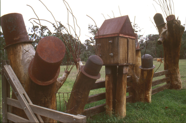 Nillumbik Shire Council
Sculpture: Tony Trembath (b.1946 Sale, Victoria), Tony Trembath, The Fences Act 1968 - Location: Edendale Farm (entrance) 30 Gastons Road, Eltham, 1989 - 1994
Eltham Council (now the Shire of Nillumbik) commissioned this work in 1989 to create an entrance / gateway to Edendale Community Farm. It was also aided by a grant from the Ministry of the Arts (now Arts Victoria). The former name of this work was "Gateway to Edendale Farm". Edendale Farm is a demonstration farm modelling sustainable environmental practices, providing support to the local residents of Nillumbik. Established in 1986, the land was purchased in 1970. It was previously an English gentleman's residence and was used for grazing. It consists of 5.6 hectares, with the Diamond Creek meandering through the property. The Victorian Fences Act 1968 governs liability of occupiers of adjoining lands to fence, and deals with disputes between neighbours regarding boundaries fences and costs. This work took into consideration ideas and suggestions from residents and committees, who required the use of recycled materials and that the work celebrate man's relationship with nature, animals and the earth, as well as relate to the fence-line on the far side of the carpark. Trembath also absorbed significant aspects of local history, making references to Eltham's agricultural past, the clearing of the land, the destruction of trees, the ruthless pruning of trees by suburban Councils and incorporated such Australian features as the post and rail fence. 'The Fences Act 1968' is significant for aesthetic, historic and social reasons at a regional level. It makes prominent the historical and social significance of Edendale and the rural aspects of Nillumbik. The use of existing tree stumps and salt pots in the work explores the iconography of the countryside such as the isolated farmhouse, pioneering farming practices, post and rail fencing and the regrowth of lopped trees. The title of the work, as well as the extensive community involvement in its creation, also makes reference to the Victorian Fences Act 1968, which makes neighbours jointly responsible for the cost of construction and maintenance of fences in the partitioning of land for settlement. 'The Fences Act 1968' has been classified as of regional significance by the National Trust of Australia. The work is an installation of wood and metal, approximately twenty five meters long. The design is very informal and rustic and runs the full width of the fence-line. It comprises groups of recycled tree trunks fitted with metal caps (chrome-nickel 'salt pots' that are shaped like tall bowler / top hats). Metal rods protrude from the trunks and some of these rods have metal birds. Two larger, sentinel-like stumps at the two outer ends have metal flame-like wings, which bend inward. To the left of the entrance, a simple architectural element indicates an isolated farmhouse. The rustic fence runs between the groups of tree trunks with native planting in clumps along it. The fence-line incorporates a functional engineered double gate and post and rail fencing. There may be many interpretations of the work and the intention is to stimulate interest and imagination rather than alienate. Interpretation is based on the personal experience that a visitor brings. The artist recommended that no explanation of the design logic be positioned with the work. N/Apublic art, sculpture, edendale, recycled, wood, metal, fences act 1968, gate, trembath, salt pot, tree stumps -
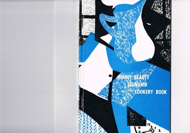 Kiewa Valley Historical Society
Book - Reference Cooking, Mount Beauty Souvenir Cookery Book x2, Circa 1962
This cookery book was printed in the early 1960s for the purpose of obtaining the necessary funds for the construction of the Mount Beauty swimming pool. The advertisements within this book covers local traders of this time frame, for example, the Bogong Hotel which is no longer operational. the culinary measurements are in Imperial measures(pounds and ounces). The book has sections for continental dishes and sweets (Australian flavour), special dishes for Lent, cakes (farmhouse fruit cake), jams, marmalades (home made), marrow and apple chutney. Some of these recipes are early 20th Century related and in the 2000s are not sought after. The food "take away" lifestyle has been responsible for the demise of a lot of the recipes in this book. The swing away from home grown produce has been not only a lifestyle change but also the faster pace of living in rural areas. The specialisation and redefined development of the local produce store (previously provided everything the rural shopper needed) was a forced move due to larger and cheaper city born fresh food supermarkets. Although there are still some local produce store within the region these will in time vanish. This cookery book was produced just after Mount Beauty was released from an SEC "closed" community in 1961(see KVHS 0134) and the town then had to fend for itself. This book was compiled and produced because the town needed a swimming pool (which possible would have been provided had the SEC still been responsible). The book demonstrates the strong rural psyche of rallying together for the good of all and united for something which would be of benefit to all. The period 1961 to the 1970s was one of great change for Mount Beauty. The SEC protective cage was a blessing for some but a goal for others. The independence that was gained after the SEC left provided for a drastic "make over" in regards to the facilities provided for the "locals" and that for the tourists. An increase in tourist related industries such as snow skiing in winter, hang gliding and gliding, mountain bike rallies, bush walking and horse riding, all of which have supply outlets in the town, has provided a more cosmopolitan atmosphere. These activities and the greater interaction with populations outside of the region has reduced the "hermit" type feel of the town psyche.This recipe book consists of eighty nine pages in black and white print. It contains black and white sketches, recipes of local domestic cooks and advertisements covering local traders. The cover is approximately 280 g/m2 in weight and the pages are at 90 g/m2 in weight. The cover has a design in the style of Abstract Expressionism (period 1950-1960s) of identifiable (clock,jug,fruit,window) and abstract objects in tints of blue and shades of black. This was designed by Cheryl Ryder of the Mount Beauty High School, under supervision of Mr I Baker (Art Teacher)On the foreword(page two and page three) "Mt. Beauty Souvenir Cookery Book First Edition" . This foreword was presented by Rosa Kinnear, President, Ladies' Auxiliary 2nd copy - no inscriptionrecipe, cooking, food, domestic, kitchen, local history, comfort food, pioneer cleaning methods -
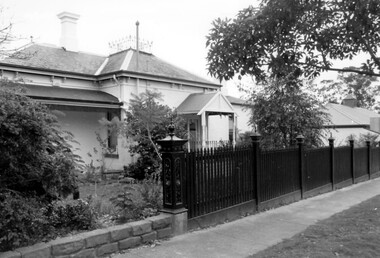 Surrey Hills Historical Society Collection
Photograph, "Ancyra" 25 Weybridge Street, Surrey Hills
John Butler Maling, retired farmer, built his home on the corner of his property which extended from Weybridge Street to Whitehorse Road and from James to Ross Street. From 1853 he lived in a simple farmhouse located near the present Ross Street until he had 'Ancyra' built in c.1889 from bricks made from clay dug from a quarry on the property. This was located in the now-park in James Street. John Butler Maling Snr was born in Shepreth, Cambridgeshire. He married Kate Conlan in 1882 and they had 3 children - Silas, Alick and Zillah. He died in 1912 and is buried in Box Hill Cemetery. Often referred to as John Butler Maling Senior as he had a nephew by the same name. He also lived on a similar sized property known as 'The Willows', located to the west. He became the first Mayor of Camberwell. From c1936 til c1960 the property was used as a rest home (Ancyra Rest Home) and then a nursery (Pied Piper Nursery).This property is important as one of few remaining extant links to pre-urban Surrey Hills, and built from local material.A black and white photograph of a brick house with a slate roof and corrugated iron over the verandah and portico. A picket fence painted a dark colour features decorative finals on the tops of the posts.ancyra, house names, weybridge street, surrey hills, whitehorse road, james street, ross street, john butler maling (snr), mrs kate maling, silas maling, alick maling, zillah maling, miss kate conlan, box hill cemetery, ancyra rest home, pied piper nursery -
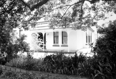 Surrey Hills Historical Society Collection
Photograph, "Ancyra", 25 Weybridge Street, Surrey Hills
John Butler Maling, retired farmer, built his home on the corner of his property which extended from Weybridge Street to Whitehorse Road and from James to Ross Street. From 1853 he lived in a simple farmhouse located near the present Ross Street until he had 'Ancyra' built in c.1889 from bricks made from clay dug from a quarry on the property. This was located in the now-park in James Street. John Butler Maling Snr was born in Shepreth, Cambridgeshire. He married Kate Conlan in 1882 and they had 3 children - Silas, Alick and Zillah. He died in 1912 and is buried in Box Hill Cemetery. Often referred to as John Butler Maling Senior as he had a nephew by the same name. He also lived on a similar sized property known as 'The Willows', located to the west. He became the first Mayor of Camberwell. From c1936 til c1960 the property was used as a rest home (Ancyra Rest Home) and then a nursery (Pied Piper Nursery). This is one of relatively few surviving houses that provides links to pre0urban Surrey Hills. It is also built from locally quarried material.A black and white photograph of a house viewed through the front garden.ancyra, house names, weybridge street, surrey hills, james street, bricks, john butler maling senior, miss kate conlan, mrs kate maling, alick maling, silas maling, zillah maling, ancyra rest home, pied piper nursery, box hill cemetery -
 Eltham District Historical Society Inc
Document - Property Binder, 66 Susan Street, Eltham
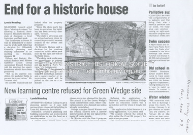
Newspaper clipping (photocopy/digital only): End for a historic house, Lyndal Reading, Diamond Valley Leader, February 1, 2006, p9Alistair Knox Park, Eltham, Eltham Skate Park A small cream cottage with green roof. The farmhouse built in the late 1800s by the Crozier Family. Subsequently owned by the Hill Family. Purchased in the early 1960s and by 1965 the property was owned by the Shire of Eltham. Employees of the Shire lived in the house. Susan Street originally ran all the way north of Bridge Street to the bend where it turned to the left into Brisbane Street. Today that section of Susan Street has been renamed as an extension of Brisbane Street. In 2006 the Shire of Nillumbik demolished the house which had been subject to extensive vandalism. In accordance with heritage advice and a permit condition a sign was placed on the site outlining the history of the building. This was installed and remained in place till about 2016 when it was removed. The land adjoins Alistair Knox Park. By 2010 the Eltham Skate Park was developed. In 2022 a major renovation and extension took place. Sources: EDHS Newsletter No 171 November 2006alistair knox park, eltham, eltham skate park, house, susan street -
 Chelsea & District Historical Society Inc
Photograph - Mr Hugh Brown's Farm, "Pine Vale", c 1865
Mr Hugh Brown farm, collecting logs for fence and preparing the ground to grow fruit trees. Mr Brown planted 8 acres of fruit trees. Hugh Brown (1830-1930), born in Ireland, arrived in Adelaide in 1855 and in the Mordialloc district in 1856. Mr Brown brought land in 1866 and built his farmhouse “Pine Vale” in 1870 near the site of the present Mordialloc Secondary College (then part of the property) and extended his property when the swampland was made open for selection in 1871. The property was a market garden and orchard. Hugh Brown married Zillah Baxter (1866) and they had six sons, five living to adulthood. The Brown family increased their land holding until they held a major part of the farmland between Mordialloc Creek to almost the Aspendale Railway Station. The property was a market garden and orchard. Mr Brown took an active interest in the public life of the community, a Justice of the Peace; Councillor of Dandenong Shire for over 30 years, was twice Shire President; and a founding member of the Mordialloc Mechanics Institute. Black and white studio photo of Mr Hugh Brown's farm. Gum trees and cleared land.hugh brown, mordialloc, pioneer, pine vale, farm, orchard, fruit trees, cattle, wagon track, fence -
 Chelsea & District Historical Society Inc
Photograph - Jean Brown And Francis Anderson, Wedding Photo, 1930
Zillah Jean Brown, known as Jean, was the daughter of Frederick Brown and the granddaughter of a pioneer of the district, Mr Hugh Brown. Jean married Francis Anderson in October 1930. Hugh Brown (1830-1930), born in Ireland, arrived in Adelaide in 1855 and in the Mordialloc district in 1856. Mr Brown brought land in 1866 and built his farmhouse “Pine Vale” in 1870 near the site of the present Mordialloc Secondary College (then part of the property) and extended his property when the swampland was made open for selection in 1871. The property was a market garden and orchard. Hugh Brown married Zillah Baxter (1866) and they had six sons, five living to adulthood. The Brown family increased their land holding until they held a major part of the farmland between Mordialloc Creek to almost the Aspendale Railway Station. The property was a market garden and orchard. Mr Brown took an active interest in the public life of the community, a Justice of the Peace; Councillor of Dandenong Shire for over 30 years, was twice Shire President; and a founding member of the Mordialloc Mechanics Institute. Black and white studio photo of the wedding of Miss Jean Brown and Mr Francis Anderson on the verandah of the house.The Yeoman Studioshugh brown, mordialloc, jean brown, zillah brown, francis anderson, wedding -
 Chelsea & District Historical Society Inc
Photograph - Jean Brown And Francis Anderson, Group Wedding Photo, 1930
From Left to Right: Margaret Watson, Hugh Brown, Frank Anderson, Jean Brown, Mary Anderson, Bill Armstrong Zillah Jean Brown, known as Jean, was the granddaughter of a pioneer of the district, Mr Hugh Brown. Jean married Francis Anderson in October 1930. Hugh Brown (1830-1930), born in Ireland, arrived in Adelaide in 1855 and in the Mordialloc district in 1856. Mr Brown brought land in 1866 and built his farmhouse “Pine Vale” in 1870 near the site of the present Mordialloc Secondary College (then part of the property) and extended his property when the swampland was made open for selection in 1871. The property was a market garden and orchard. Hugh Brown married Zillah Baxter (1866) and they had six sons, five living to adulthood. The Brown family increased their land holding until they held a major part of the farmland between Mordialloc Creek to almost the Aspendale Railway Station. The property was a market garden and orchard. Mr Brown took an active interest in the public life of the community, a Justice of the Peace; Councillor of Dandenong Shire for over 30 years, was twice Shire President; and a founding member of the Mordialloc Mechanics Institute. Black and white studio photo of the wedding party of Miss Jean Brown and Mr Francis Anderson.hugh brown, mordialloc, jean brown, zillah brown, francis anderson, wedding, margaret watson, mary anderson, bill armstrong -
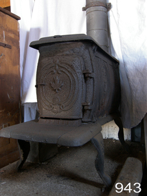 Flagstaff Hill Maritime Museum and Village
Domestic object - Stove, 1850-1890
In the industrialized world, as stoves replaced open fires and braziers as a source of more efficient and reliable heating, models were developed that could also be used for cooking, and these came to be known as kitchen stoves. The first manufactured cast-iron stove was produced at Lynn, Mass., in 1642. This stove had no grates and was little more than a cast-iron box. About 1740 Benjamin Franklin invented the “Pennsylvania fireplace,” which incorporated the basic principles of the heating stove. The Franklin stove burned wood on a grate and had sliding doors that could be used to control the draft (flow of air) through it. Because the stove was relatively small, it could be installed in a large fireplace or used free-standing in the middle of a room by connecting it to a flue. The Franklin stove warmed farmhouses, city dwellings, and frontier cabins throughout North America. Its design influenced the development of the pot-bellied stove, which was a familiar feature in some homes well into the 20th century. The first round cast-iron stoves with grates for cooking food on them were manufactured by Isaac Orr at Philadelphia, Pa., in 1800. The base-burning stove for burning anthracite coal was invented in 1833 by Jordan A. Mott. The subject item is a mid to late 19th century settlers stove probably of Canadian manufacture imported into Australia around this time. The stove gives us a social snapshot into what life must have been like for our early colonialists using this device for heating and cooking in their meagre homes. Cast iron stove with four-legs, 2 plates on top and a hinged front door. The door has been cast with a maple leaf design and the sides have a pattern cast into them.flagstaff hill, warrnambool, shipwrecked-coast, flagstaff-hill, flagstaff-hill-maritime-museum, maritime-museum, shipwreck-coast, flagstaff-hill-maritime-village, stove, domestic heating, domestic cooking, heater, cooking unit, pot belly stove, wood fired stove, wood stove -
 Glen Eira Historical Society
Document - Frogmore
... Farmhouses ...Eight pages of photocopied extracts from a family history of the Lyalls who owned the property Frogmore in Murrumbeena. The history was written by Mary G Lyall Davis and published in 1993. One page includes a hand drawn illustration (60mm x 110mm) of the exterior of Frogmore.frogmore, lyall william, lyall davis mary g, cahill p, murrumbeena road, warrien road, wahgoo road, koornang road, north road, murrumbeena, carnegie, cattle, livestock, horses, farmhouses, graziers, farming, stock breeding centres, murray peter r, mickle john, wells john c, mickle alexander, mickle agnes, lyall andrew, brown helen, patterson mr, maxwell thomas, leman swamp, lyall annabella -
 Federation University Historical Collection
Photograph - black and white, Mr Downing by the Federation University Tree of Knowledge, 1970
Federation University Mount Helen Campus was open to students in 1970. In that year Mr Dowling as photographed beside a big Tasmanian bluegum which was used a the centre Mount Helen Campus concept plan, and later became known as the Tree of Knowledge. Mr Dowling watered the tree after it was planted by his mother, Elizabeth Downing, on Arbour Day 1896. Mrs Downing raised her large family on the site of the Mount Helen Campus, which included an orchard and milking cows. The Tree of Knowledge is actually two trees, the trunks have fused together over time, and there is further evidence of fusion. The Downing farmhouse was situated in the vicinity of the present Administration and Caro Conference Centre buildings and the tree was planted beside the "dunny". It was carefully watered by the nine Downing children from a brick-lined well situated under what is now the Albert Coates Building. As the tree grew to maturity, it was used to hang a meat safe after slaughtering a sheep for the family table. Some years ago, when the foundations were being dug for the E-Building, an old rusted percussion pistol was found. One of Mrs Downing's sons, at that time well into his nineties, remembered getting into trouble for playing with it without permission, and losing it. The land was purchased in 1966 as part of a 241-acre site for Ballarat's new tertiary institution. When the architects and planners inspected the site, they decided "The Big Tree" must remain as a central landmark in preparing the layout of the campus amenities. In 1982, the spread of the tree was 36 metres, girth 7 metres, and height 36 metres. By 2003 the spread was 39.5 metres (N-S) and 35.5 metres (E-W), girth 7.75 metres, and height 42.5 metres. A man in overalls and jacket stands beside the Federation University Tree of Knowledge. Stage one buildings on the Mount Helen Campus are evident in the background.elizabeth downing, downing, tree of knowledge, big tree, mount helen campus, mount helen