Showing 163 items
matching industrial areas
-
 Eltham District Historical Society Inc
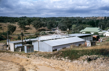
Slide, Maroondah Aqueduct, Research, Victoria, 22 Mar. 1981
This view shows the area that would develop into the Research Industrial Estate. In centre distance though largely hidden by trees is the site of the Research Hall, which was later demolished and a new Eltham Little Theatre constructed in 1988 as a bicentennial project. The hills in the distance near the power lines now a housing estate.35 mm colour positive transparency (1 of 5) Mount - Agfachrome Agfa CS System black 8 dotsactivities, heritage excursion, maroondah aqueduct, research (vic.), shire of eltham historical society -
 Federation University Historical Collection
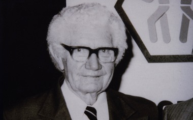
Photograph - Photograph - black and white, VIOSH: Harold Greenwood Thomas: Founding member of the Safety Engineering Society of Australia, c1950
Victorian Institute of Occupational Safety and Health (VIOSH) Australia is the Asia-Pacific centre for teaching and research in occupational health and safety (OHS) and is known as one of Australia's leaders in the field. VIOSH has a global reputation for its innovative approach within the field of OHS management. VIOSH had its first intake of students in 1979. At that time the Institution was known as the Ballarat College of Advanced Education. In 1990 it became known as Ballarat University College, then in 1994 as University of Ballarat. It was 2014 that it became Federation University. VIOSH Australia students are safety managers, senior advisors and experienced OHS professionals. They come from all over Australia and industry. Students are taught active research and enquiry; rather than textbook learning and a one-size fits all approach. VIOSH accepts people into the Graduate Diploma of Occupational Hazard Management who have no undergraduate degree - on the basis of extensive work experience and knowledge. Harold Greenwood Thomas was one of a group of students who founded the Safety Institute of Australia (SIA). They all had attended the first Industrial Safety and Accident Prevention Course conducted by Melbourne Technical College in 1948. Due to his long service to safety and prevention there is the Harold Greenwood Thomas Lifetime Achievement Award. This is the most prestigious award by the Institute and may be issued to a person who has demonstrated a combination of long term outstanding and influential contribution to the profession in a specific or generalist area of Occupational Health and Safety and Work Health and Safety, where there work has made a major impact on outcomes in Australian workplaces. The Award will be issued once annually, but the board retains the right not to award in any given year, or in special circumstances more than once in a year. It Award is for an individual. Dennis Else, VIOSH Ballarat, is the 6th person to win the Harold Greenwood Thomas Lifetime Achievement Award. This was in 2021Photograph - Black and Whiteviosh, harold greenwood thomas, safety institute of australia, sia, dennis else -
 Federation University Historical Collection
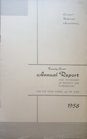
Booklet - Annual Report, Greater Ballarat Association Annual Report 1952-1974, 1952-1974
The first presedent of the Greater Ballarat Association in 1938 was Robert J. Cooke. Eighteen annual reports of the Greater Ballarat Association. Each one discussed the work of the association and lists the subscribers. greater ballarat association, annual report, edgar bartrop, g.b. richmond, a.w. nicholson, g.e. deeble, r.g> caddell, l.j. fraser, t.u. haymes, a.w. lynch, keith rash, tourist bureau, botanical gardens telepone booth, pryor park tree planting, ballarat zoological gardens, centenary window dressing competition, soldier settlement, proposal for university for ballarat, caravan park, ballarat common, ballarat common development, t.t. hollway, housing commission, wendouree housing commission, industrial development, s.s. ballarat, begomia festiva, r.g. caddell, w.gordon smith, f.h. menzies, olympic rowing, royal tour decorations, begonia float, widening of railway bridge, j. chatham, l.g. chester, s.v. playsted, n. ellis, langi kal kal, langi kal kal training centre, migrants to victoria, flood lighting of the arch of victory, olympics holidays, ballarat's projected olympic pool, ballarat fish hatcheries, olympic hostel, town planning, murray byrne, titles for residence areas, service club signs, railway level crossing, traffic, ploughing competition, w. fraser, young australia league, removal of raaf from ballarat, renumbering of streets, renumbering of streets to the block system, miners' racecourse reserve, historical museum, ballarat historical society, c.m. canty, mavis canty, university status, ballarat university college, j.w. murray, p.r. gray, b.c. mcorist, n.c. ellis, w.h. heinz, save the lake campaign, lake wendouree, weed, home host scheme, b. walker, develop victoria council, eureka development, victorian decentralization league, r.h. ramsay, allan c. pittard, w. gordon smith, c.h. davis, b.c. hedgcock, les kennedy, p.j. rice, a.f. waddington, john p. cook, historic markers, maze, traffic lights, bungal dam, camera clubs, sunraysia way, map, centre of road parking, paddle steamer, wendouree apex, local government women's association, may nelson, wes sobey, melton foo, l.l. zilles, dulcie sullivan, m. barnes, lou zilles, john wesley sobey, e.r. ingles, herb warren, kryal castle -
 Flagstaff Hill Maritime Museum and Village
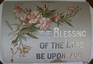
Decorative object - Wall Decoration, 1850 to 1901
This item is part of the Giles Collection, dating back to the late Victorian era, from the 1880s to the early 1900s, in which Queen Victoria ruled England. The queen’s influence was felt throughout the world, including in the United States and Australia where Victorian values shaped society and style, especially in home décor. This period’s distinct style presents an eclectic mix of highly ornamented furniture, wallpaper, and knick-knacks. Particularly in terms of furniture, and the characteristic floral patterns and rich, contrasting colours, wall hangings that enjoyed the height of their popularity during the Victorian era were of the spiritual type with either embroidered or punched paper religious motto or bible quote. Mottoes were commonly hung high up on the wall or in an area of prominence, to remind the viewer of their important message, such as “He Leadeth Me” and “Honesty, Industry, and Sobriety.” Short and pithy, they embodied the ideals of Victorian society. Technological advances contributed to the boom of religious mottoes whereas before the Industrial Revolution home décor of this sort was handmade and therefore minimal, now consumers could purchase and fill their homes with all sorts of mass-produced ephemera goods similar to the subject item. Many of these mass-produced period pieces still exist today, often in their original frames, ceramic, enamelled or paper formats. Flagstaff maritime museum has many examples of mottoes on display that serve to reflect the period in which values of home, faith, and Christianity were very prominent in everyday Victorian society. The Giles Family There are many 19th century items of furniture, linen and crockery donated to Flagstaff Hill Maritime Village by Vera and Aurelin Giles. The items are associated with the Giles Family and are known as the “Giles Collection”. These items mostly came from the simple home of Vera’s parents-in-law, Henry Giles and his wife Mary Jane (nee Freckleton), whose photos are in the parlour. They married in 1880. Henry Giles was born at Tower Hill in 1858. He was a labourer on the construction of the Breakwater before leaving in 1895 to build bridges in N.S.W. for about seven years. Mary Jane was born in 1860 at Cooramook. She attended Mailor’s Flat State School where she was also a student teacher before, as a family legend has it, she became a governess at “Injemiara” where her grandfather, Francis Freckleton, once owned land. Henry and Mary’s family of six, some of whom were born at Mailor’s Flat and later children at Wangoom, lived with their parents at Wangoom and Purnim west, where Henry died in 1933 and Mary Jane in 1940.The Giles family collection has social significance at a local level, because it illustrates the level of material support the Warrnambool community gave to Flagstaff Hill when the Museum was established. This wall decoration reflects the social values and attitudes of the late Victorian era that was used to promote good Christian and moral values in many households. These items of decoration were very popular at this time and the subject item is significant as it gives a snapshot into the social norms of past generations. Printed card wall hanging with floral design. Religious text on the sign is embossed onto the card and highlighted in silver print. There is a handwritten ink inscription, and a pencil inscription, on the back. A string is attached to two holes on top of the card. Embossed"THE BLESSING / OF THE LORD/ BE UPON YOU." "PS 129.8." In pencil "H/S" In ink "To dear Granny with lots of love / from Dorothy. X X."flagstaff hill, warrnambool, shipwrecked coast, flagstaff hill maritime museum, shipwreck coast, great ocean road, paper wall decoration, religious, home decoration, societal values, victorian moral values, wall hanging, wall decoration, spiritual decoration, bible verse, giles collection -
 Mission to Seafarers Victoria
Photograph - Photograph, Black and white, Allan Charles Quinn, The fishing harbour, Gothenburg, Sweden, 9 July 1950
This series of photographs captures life at sea and the conditions on the ship M/S "Mongabarra" Goteborg in 1950.This photograph is part of the Allan Quinn collection, which is a pictorial autobiography, and it represents one of many moments of his time abroad as a seafarer.Black and white photograph of a fishing harbour in Gothenburg, Sweden, 1950. In the bottom left corner of the photograph are roofs of buildings. In the bottom right corner of the photograph is a ships dock area with a warehouse, crates, and several ships docked. This section extends towards the middle of the photograph. The background is very industrial with large ships and machinery. This section of the photograph is very dark.On the back of the photograph is the date 9/7/50 in blue ink.1950, ships, river, industrial, masts, sweden, mongabarra, allan quinn collection, allan quinn, gothenburg, warehouse, dock, houses -
 Greensborough Historical Society
Article and Photograph, Para Road industrial strip, 2017_
Photographs and captions relating to the Para Road industrial strip in Greensborough.This text and photographs were copied from a Facebook site. Members are people who lived in the Greensborough area and share their reminiscences of the area with others. The site is administered by a GHS member but is not officially affiliated with the Society. Any information is the opinion of the contributor. Photographs and text sourced from social media.para road greensborough -
 Glenelg Shire Council Cultural Collection
Administrative record - Survey - Industrial and Commercial Potential of Portland, Victoria, Apr-71
-
 Kiewa Valley Historical Society
Photograph Farm Land, Mount Beauty Acreage before Golf Course, Circa 1950
This photograph is a "snap shot" in time circa 1950s detailing the rural environment before the effects of the Kiewa Valley Hydro Scheme altered the basic rural setting of the valley. The golfing fairway was being mapped out on previous grazing land, before the laying of a golf course, for use by the construction workers and auxiliary administration employees of the Victorian State Electricity Commission. This photograph details a dramatic period in time which saw an enormous change to the exclusively rural area of the Kiewa Valley region in the mid 1900s. This change presented both physical and mental challenges to the existing quiet rural inhabitants of the valley. The State of Victoria had to make adjustments to the changing demands imposed by population and industrial expansions. The development of cleaner energy supplies to a growing population has its downside ,which ever way the intrusion into the "natural" landscape is made.Black and white photograph detailing surveyor posts for construction of golf course. Land used, before establishment of the Mount Beauty Village, as farming/grazing cattle and viewed towards Mount Bogong and its Alpine ranges. The photo is on 200gms paper and not on photographic paper.nilmount beauty in the 1940s - 1950s, grazing in the kiewa valley, sec victoria -
 Kiewa Valley Historical Society
Photograph Transmission lines Mount Beauty, 66 KVA Transmission lines from Clover Power Station, Circa 1950
This photograph is a "snap shot" in time circa 1950s detailing the rural environmental change and the progressive effects of the Kiewa Valley Hydro Scheme on the basic rural setting of the valley (note the sparsity of rural infrastructure). This photograph shows the beginning of the accommodation and administration buildings for use by the construction workers and auxiliary administration employees of the Victorian State Electricity Commission. It also provides a view of the landscape before extensive development of Pondage and other non rural buildings.This photograph details a dramatic period in time which saw an enormous change to the exclusively rural area of the Kiewa Valley region in the mid 1900s (see sparse rural buildings/houses). This change presented both physical and mental challenges to the existing quiet rural inhabitants of the valley. The State of Victoria had to make adjustments to the changing demands imposed by population and industrial expansions. The development of cleaner energy supplies to a growing population has its downside ,which ever way the intrusion into the "natural" landscape is made. The construction of the large Pondage at the centre of the photograph is a good example.This black and white photograph of a panoramic view of the Kiewa Valley (Mount Beauty SEC construction workers village) shows the newly completed transmission line towers delivering electrical power(66KVA) from the Clover Power Station. The photo is on 200gms paper and not on special photographic paper.mount beauty 1940 to 1950s, development of sec kiewa hydro scheme, sec victoria -
 Kiewa Valley Historical Society
Meter Millivolt, after 1950
This milli-volt meter was manufactured after 1950 and used by the SEC Vic (Kiewa Hydro Electricity Scheme) from that date until late 1900's. It was used to measure very small voltages associated with the operation of the various Hydro Generators. The readings were able to be shown by the resistor in use in the current circuit. During this time period, high quality testing instruments were either sourced from Europe or England.This milli-volt meter is very significant to the Kiewa Valley as it was used by those electrical technicians, who were part of the Kiewa Hydro Scheme. An "off spin" from the Scheme was the beginning of an explosion in "human" resources into the Kiewa Valley. This influx of population transformed the region from that of a basically quiet rural region to one which evolved into both industrial and larger residential community. This evolution in the Kiewa Valley created a change, not only in the "physical" landscape(better roads and infrastructure), but also the socio-economic growth within the Valley allowing other "tourist" based industries to expand within the valley and Alpine areas.This millivolts DC meter was used in the 1950's. It is contained in a wooden box and has two coloured (red/black, positive and negative) screw tight knobs which have bake-lite connections. It also has a covered (black tin) view meter marked from zero to 10 millivolts. Underneath this and within a round bake-lite is a small adjustment screw. The top of the box is fastened onto the main structure by six brass screws. The back of the structure is fastened by eight brass screws and there are four small bake-lite rest knobs.On the face of the millivolt compartment , and at the top "TO BE USED WITH DIAL HORIZONTAL TEMP. COEF. +- .08 % PER oC. Underneath the scale "MILLIVOLTS D.C. F.G." (LEAD RESIS. .05 OHMS)" underneath and to the left "MADE IN ENGLAND BY" "EVERSHED & VIGNOLES Ltd" and to the right "No. 857842" underneath Regd. TRADE MARK MEGGERkiewa valley tourism, victorian alps, alternate energy supplies, alpine population growth -
 Eltham District Historical Society Inc
Photograph, View of water tower and industrial area, Candlebark Court, Research
... View of water tower and industrial area, Candlebark Court... photograph View of water tower and industrial area, Candlebark Court ...Colour photographcandlebark court, research (vic.), water tower -
 Eltham District Historical Society Inc
Photograph, Para Road, Montmorency, industrial area looking south from Plenty River Bridge on boundary of Shire of Eltham
... Para Road, Montmorency, industrial area looking south from..., Montmorency, industrial area looking south from Plenty River Bridge ...Colour photograph02076, montmorency (france) photo album, montmorency, para road, plenty river, industry -
 Kiewa Valley Historical Society
West Kiewa Alpine Way and Day Ski Resort
In June 1982 This research report on the West Kiewa Alpine Way Proposal was sent to the Mt Beauty Chamber of Commerce. "The economic, tourist market and geographic factors are the kernel of the proposal." From Industrial Relocations Consultants Pty. Ltd.The proposal was to benefit the tourism industry.Manila foolscap folder with metal fastener. Papers dated June 1982 re - "Proposed West Kiewa Alpine Way and Day Ski Resort" Also enclosed but not related: Letter from Falls Creek Tourist Area Management Committee July 1984B. Goss written on coverwest kiewa alpine way, day ski resort, mt beauty chamber of commerce -
 Kiewa Valley Historical Society
Photograph Clover Dam, Clover Dam Circa 1940, circa 1940s to 1950s
As part of the push to cut electricity costs and diversify supply, the Victorian Government (circa 1930) implemented the conversion strategy from mainly brown coal supply to hydro - electricity. The Kiewa Hydroelectric Scheme became the largest scheme of its kind in the State Of Victoria and the second largest scheme in Australia. This dam was constructed to supply water to feed four turbines (62 mega watts) at the West Kiewa Power Station. This was at the forefront of sustainable "Green" energy. Costs associated with power supplies is still a major incentive of governments, however environmentally friendly alternatives such as wind and nuclear have also made inroads. The Kiewa valley and its surrounding alpine catchment were looked at(Victorian State Government), from the beginning of the twentieth century as a source of alternate power for an every increasing demand for electricity by growing population and heavy industrial ares within Melbourne City and State regions. Construction of dams, such as Clover Dam provided the large quantity holding areas of water required to turn the turbines at the various power stations to provide the electricity needed. The impact of these controls by moderating water run off from the alpine regions is beneficial in reducing flooding from thawing of snow on the alps. This by-product allows agriculture and grazing to be less vulnerable to seasonal flooding thereby resulting in a more stable annual production level.Reproduction (scanned) of a black and white photo of Clover Dam circa 1940. The paper used is KodakXtraLife II paperThe reverse side of photo " KodakXtraLife II paperdams, pondage, hydro electricity, power stations, clover dam, secv -
 Kiewa Valley Historical Society
Photograph of Lake Guy Dam, Spillway, Lake Guy Dam, c1945
In December 1939 the excavation of the diversion tunnel at the site of Junction (Lake Guy) Dam was commenced and finished in February, 1940.This allowed the stream to be diverted to facilitate the dam wall construction. This is a 'slab and buttress' dam. It is framed with timber and concrete then poured into the structure. A contract was let to Lewis Construction Co. for the construction of the dam, and the first batch of concrete was placed in September, 1940. Industrial trouble caused some delays but there was also slow progress on the part of the contractor and the work was taken over by the S.E.C., terminating the contract. The dam was completed in March, 1944. The lake is named after Mr. L.T. Guy who was the Resident Engineer, in charge of construction work and associated activities on the Kiewa area, from 1939 until November 1946. An historical pictorial record taken for the State Electricity Commission of Junction Dam (Lake Guy) on spill. Mt. Arthur is in the background and there is still evidence of the destruction of trees from the 1939 bushfires. Black and white photograph of Lake Guy Dam . The dam is spilling and Mt. Arthur is in the background. Hand written on back of photograph in blue ink " Lake Guy Dam".dam, lake, water, mr. l.t.guy -
 Kiewa Valley Historical Society
Photograph of Lake Guy Dam, Walkway, Inside Lake Guy Dam, c 1945
Lake Guy Dam is a 'slab and buttress' type wall. A timber frame is built and then filled with concrete. The first batch of concrete was placed in September, 1940. By June, 1941 the buttresses were finished to a height safe from floods and in October of that year a flood of 2,800 cusecs occurred but with only slight damage to the installations. Industrial trouble caused some delays but there was also slow progress on the part of the contractor and the work was taken over by the S.E.C., terminating the contract. The dam was completed in March, 1944. A walkway was made through the dam wall. Lake Guy was named after Mr. L.T. Guy who was the Resident engineer, in charge of construction work and associated activities on the Kiewa Area from 1939 to November 1946.Shows the walkway placed as part of the Lake Guy (Junction) Dam wall. A very good pictorial reference for the future.Black and white photograph of the walkway through Lake Guy (Junction) Dam wall.Handwritten in blue ink on back of photograph "Inside Lake Guy Dam". slab, buttress, dam, mr. l.t. guy -
 Kiewa Valley Historical Society
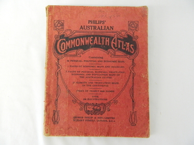
Atlas Australian Commonwealth, Philips' Australian Commonwealth Atlas, 1944
This atlas, printed in 1944, details not only the geographic and political boundaries of the world as it was at that time but also the snap shot of life of the time. This snap shot in time covers the major Australian cities, the major farming, grazing, industrial and sporting/recreational activities. Also there are snap shots of similar activities from other global areas. The period also covered World War II, detailed by a photo of "shell making", munitions, required by Australian soldiers. The great political and territorial changes made as a result of World War II can be clearly identified for example , Israel (the Jewish homeland). The various prewar colonies of major European nations.This atlas was used by children of a Kiewa Valley family and shows the value and the general educational exposure that these children had at this time. The rural setting and within the backdrop of a world war did not severely alter the life style of children in this region. The "news reels" shown in cinemas of cities and larger towns were the only visual realisations of major events of global significance available to these children. The information provided by this atlas allowed students to glimpse at what the "outside world" was. The majority of these students would possibly never see these regions for themselves. The great communication facilities of the late 1900s and beyond, was still only science fiction.This atlas has a thick (350 g/m) red cardboard cover with bold black lettering and shading. The cover is set out within a shield like frame. The shield is held up by two square markings, each with a four part circular pattern and a cord entwining two pendulum structures ending with a bowl figure at the bottom. There is a semi circular form enclosing a printed book contents list. The inside cover has the atlas title and contents and the publisher details. The atlas contain 56 pages of world and Australian maps, vegetation and rainfall maps. Within this atlas there are 27 double sided pages of black and white photographs depicting life styles, buildings, landscapes and prominent and significant to Australia males from 1652 to 1944. The pages are of approximately 200 g/m and have the yellow aged appearance.On front cover "Philips' Australian COMMONWEALTH ATLAS" and underneath "Containing" underneath "60 PHYSICAL, POLITICAL AND ECONOMIC MAPS". Publisher George Philip & Son, Limited 32 Fleet Street, London E.C. 4. Inside cover are: written, in freehand and in ink the following names and dates; "J.Muller Form V 1945", "L L Muller Form IV 1946", "N.J. Muller Form I + II + III 1948 +49 + 50" and "D Muller Form I 1949". also handwritten and in pencil is "Peter Leslie". On the last page is a small freehand sketch of Australia in biro.1940s school curriculum, rural education, 1940s atlas, australian atlas -
 Warrnambool and District Historical Society Inc.
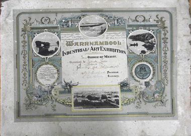
Certificate - Certificate, 1897, Warrnambool Industrial & Art Exhibition Order of Merit, pre December 1896
The following is an extract from Warrnambool and District Historical Society Website which explains briefly the Great Exhibition of 1896-97 The Great Industrial and Art Exhibition in Warrnambool in 1896-97 was an exciting affair for the town and the surrounding area. People came from far and wide to be enlightened, educated and entertained, with 70,000 visitors passing through the doors during the three months of the exhibition. Not bad for a town with a population of only 6,500 and a further 9,200 living in the surrounding shire! Planning began at a public meeting attended by 60 people in May 1896 and the exhibition opened in December the same year on the site of the current Light House Theatre. The architects submitted plans for four annexes, complete with turrets, a fernery and a giant flagpole. The site covered 1 acre and included a Marine court, industrial exhibits, an education court, defense and agriculture court, stalls, coach builders, dairy show, an art court and provision for a smorgasbord of various entertainment. (The Story of the Warrnambool Industrial & Art Exhibition 1896-97- E O’Callaghan) This certificate was one of many awards for competency and /or excellence in a wide range of activities and skills. Warrnambool Industrial & Art Exhibition 1896-1897 Competitions-Piano forte solo Gertrude Lewin- prizewinner W J Hickford- Mayor E Lyle Rossiter As a link to one of the biggest events ever held in Warrnambool this item has significant value to the history of Warrnambool. It has social significance also linking a number of names related to the event. Rectangular cardboard. pale cream and aqua background, multi linear gold and deeper aqua border with rounded and right angled corners. An interior border has a swag, linear vertical ribbons with four emblems related to science, labour, arts and industry. Four local black and white photographs, the town council crest and town officials, patron and councillors. An inscription of the prizewinner, event and signatures is written in a cream square in the middle of the certificate.Warrnambool/Industrial & Art Exhibition Opened Dec 21st 1896/ By the Chief Justice of Victoria/ Sir John Madden, K.C.M.G. upper L corner. Closed March 19th 1897/ By the Mayoress of Warrnambool/ Mrs WJ Hickford 'First Order of Merit/ Awarded to Gertrude Lewin/ of Parkville/ for Piano forte Solo (under 15) Signatures of WJ Hickford, President and E Lyle Rossiter, Secretary gertrude lewin, wj hickford, e lyle rossiter, the great warrnambool exhibitiion, warrnambool, pianoforte -
 Flagstaff Hill Maritime Museum and Village
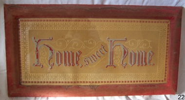
Artwork, other - Wall decoration, Vera Giles, late 19th to early 20th century
During the Victorian era, the period (1837-1901) in which Queen Victoria ruled England. The queen’s influence was felt throughout the world, including in the United States and Australia where Victorian values shaped society and style, especially in home décor. This period’s distinct style presents an eclectic mix of highly ornamented furniture, wallpaper, and knick-knacks. Particularly in terms of furniture, and the characteristic floral patterns and rich, contrasting colours, wall hanging that enjoyed the height of its popularity during the Victorian era were of the spiritual type with an either embroidered or punched paper religious motto or bible quote. Mottoes were commonly hung high up on the wall or in an area of prominence, to remind the viewer of their important message, such as "Home sweet Home “He Leadeth Me” and “Honesty, Industry, and Sobriety.” Short and pithy, they embodied the ideals of Victorian society. Technological advances contributed to the boom of religious mottoes whereas before the Industrial Revolution home décor of this sort was handmade and therefore minimal, now consumers could purchase and fill their homes with all sorts of mass-produced ephemera goods similar to the subject item. Many of these mass-produced period pieces still exist today, often in their original frames, ceramic, or paper formats. Flagstaff maritime museum has many examples of mottoes on display that serve to reflect the period in which values of home, faith, and Christianity were very prominent in everyday Victorian society. For more information on the Giles collection see Acquisition section this document: An item that reflects the social values and attitudes of the late Victorian era that was used to promote good Christian and moral values in many households. These items of decoration were very popular at this time and the subject item is significant as it gives a snapshot into the social norms of past generations. The Giles family collection is of additional social significance at a local level, because it not only illustrates the level of material support the Warrnambool community gave to Flagstaff Hill during it’s establishment. But the Giles collection also gives us an additional view into what domestic life was like in early colonial times prior to Federation.Wall decoration, framed handmade embroidered tapestry with the woven inscription, Frame has velvet cover. This item is part of the Giles CollectionHome Sweet Home, in gothic scriptflagstaff hill, warrnambool, shipwrecked coast, flagstaff hill maritime museum, flagstaff hill maritime village, great ocean road, soft furnishing, wall decoration, home sweet home, wall hanging, handmade wall hanging, giles collection, henry giles, tower hill, cooramook, warrnambool breakwater, mailor’s flat, wangoom, 19th century handcraft, mrs vera giles -
 Flagstaff Hill Maritime Museum and Village
Decorative object - Wall Decoration, Late 19th to early 20th centuries
During the Victorian era, the period (1837-1901) in which Queen Victoria ruled England. The queen’s influence was felt throughout the world, including in the United States and Australia where Victorian values shaped society and style, especially in home décor. This period’s distinct style presents an eclectic mix of highly ornamented furniture, wallpaper, and knick-knacks. Particularly in terms of furniture, and the characteristic floral patterns and rich, contrasting colours, wall hanging that enjoyed the height of its popularity during the Victorian era were of the spiritual type with an either embroidered or punched paper religious motto or bible quote. Mottoes were commonly hung high up on the wall or in an area of prominence, to remind the viewer of their important message, such as “He Leadeth Me” and “Honesty, Industry, and Sobriety.” Short and pithy, they embodied the ideals of Victorian society. Technological advances contributed to the boom of religious mottoes whereas before the Industrial Revolution home décor of this sort was handmade and therefore minimal, now consumers could purchase and fill their homes with all sorts of mass-produced ephemera goods similar to the subject item. Many of these mass-produced period pieces still exist today, often in their original frames, ceramic, or paper formats. Flagstaff maritime museum has many examples of mottoes on display that serve to reflect the period in which values of home, faith, and Christianity were very prominent in everyday Victorian society.An item that reflects the social values and attitudes of the late Victorian era that was used to promote good Christian and moral values in many households. These items of decoration were very popular at this time and the subject item is significant as it gives a snapshot into the social norms of past generations. Wall decoration white china with relief circular hanging pieces, paper folds pinned back to reveal words Paper is pinned by metal studs. Paper folds create star shape. (set of 2)Watch and Pray and Come Unto Meflagstaff hill, warrnambool, shipwrecked coast, flagstaff hill maritime museum, shipwreck coast, great ocean road, paper wall decoration -
 Federation University Historical Collection
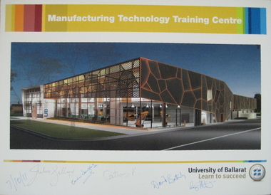
Photograph - Poster, University of Ballarat Manufacturing Technology Training Centre poster signed by Prime Minister Julia Gillard, 07/10/2011 (approx 11.15am)
The new Manufacturing Technology Training Centre (MTTC), a part of the proposed Building Construction Training Centre (BCTC), will be a purpose-built, stand-alone, fully fitted-out industry-standard facility. This new space will accommodate current course provision along with specialist training spaces for developing skill requirements in manufacturing technology such as robotics, mechatronics, engineering and industrial automation. Project funding was provided by the Education Investment Fund from the Australian Government Department of Education, Employment and Workplace Relations. The project budget is $18.09m, and the resulting building will have a floor space of 4,755m2. The Manufacturing Technology Training Centre is being built in conjunction with the Technical Education Centre (UBTec). While the buildings will have separate street identities the buildings will be joined with shared amenities areas. UBTec will provide a facility including individual learning spaces, learning studios, administration/office space, circulation, open plan learning space, staff common areas, computer rooms, meeting rooms, staff work areas and kitchen areas as well as car parking and site-wide amenities. While the buildings will have separate street identities the buildings will be joined with shared amenities areas. Funding for the UBTec component of the building is provided by Maintaining the Advantage: Skilled Victorians from the Victorian State Government. A colour poster prepared for the 'turning of the sod' at the site of the proposed University of Ballarat Manufacturing Technology Training Centre (MTTC), Grant Street, Ballarat. The poster was signed on Friday 7 October 2011 at about 11:15 am at the Building Construction Training Centre (BCTC), Grant Street, Ballarat by: Hon. Julia Gillard MP Hon. Catherine King MP (Ballarat ) Prof. David Battersby, Vice Chancellor, University of Ballarat Mayor, Cr Craig Fletcher, Mayor of the City of Ballarat appointed in December 2010 Mrs. Karen Douglas, Chair University of Ballarat Building & Infrastructure Committee The poster is signed by the Prime Minister of Australia, the Hon. Julia Gillard MP; Karen Douglas; the Hon. Catherine King MP (Ballarat ); Prof. David Battersby (Vice Chancellor); Craig Fletcher (Mayor, City of Ballarat)university of ballarat, david battersby, julia gillard, prime minister, catherine king, ubtec, karen douglas, manufacturing technology training centre, grant street, architecural feature -
 Flagstaff Hill Maritime Museum and Village
Lap Skiver, J Dixon, 1900s
Walsall in England was regarded as the world`s greatest centre of the saddlery trade. The town's craftsmen began to specialise in making bits, stirrups and spurs in the Middle Ages, developing into fully-fledged makers of saddlery and harness, by the end of the nineteenth century. As a result, over a hundred firms were exporting their products throughout the British Empire and beyond. The Walsall firms flourished as horses were so vital to everyday life in Victorian Britain and the colonies. The Walsall area emerged as a major supplier of military saddlery and harnesses, with one company supplying an astonishing 100,000 saddles for the British army in the First World War. The twentieth century saw the rise of light leather goods, such as handbags, cases and gloves. With the coming of the motor car, these products became the mainstay of the Walsall leather industry. Many companies supplied this trade and Dixon tools was one, as a commercial and industrial equipment supplier to the trade. The company started in 1843 and has continued to produce tools for the leather industries up and till August 2017 when the company was dissolved.A vintage item used in the leather working industries see additional notes at end of document for clarity on how the item was used and it's importance in making leather goods.Lap Skiver has a roller missing. Painted reddish brown J Dixonflagstaff hill, warrnambool, shipwrecked-coast, flagstaff-hill, flagstaff-hill-maritime-museum, maritime-museum, shipwreck-coast, flagstaff-hill-maritime-village, lap skiver, leather industries, leather making tools, tools, j dixon -
 Flagstaff Hill Maritime Museum and Village
Plate, before 1878
This earthenware dinner plate fragment is very similar to others recovered from the wreck of the LOCH ARD. It is uncertain whether the plates were personal belongings or part of the cargo. The Asiatic Pheasant pattern is a transfer design and was the most popular design of the 19th century Victorian era. It is still being produced today. The design was produced as high quality, decorative dinnerware by the potters in the Staffordshire, England, area from the late 1830’s, but no-one is sure exactly who the original designer was. The industrial age made production of this design more affordable to the ordinary person who purchased and proudly displayed settings in their homes. The high demand for production resulted in loss of quality in both potting and design, particularly between 1860-1914 when the design reached its height of popularity, and the results were often a poor match for the earlier pieces’ quality and detail. Some engravers would make copies of the Asiatic Pheasant design (and other designs) onto copper plates and sell them to more than one pottery producer (the Copyright Act of 1842 was intended to control this very thing). Consequently the list of Makers’ Marks associated with the Asiatic Pheasant is well over 100. A single pottery factory could have several owners, all with their own Marks. These factors all make the dating of pieces difficult. Also, after 1891, pieces produced for the export were required to be stamped with “ENGLAND”, but pieces produced for the domestic market in England did not need this stamp, so early pieces and pieces produced for the domestic marked would all be without the “ENGLAND” stamp, confusing the matter. Over time the body shape of the pieces changed, the feathered, curved and fluted edges giving way to the simpler, cheaper oblong shapes. The LOCH ARD belonged to the famous Loch Line which sailed many ships from England to Australia. Built in Glasgow by Barclay, Curdle and Co. in 1873, the LOCH ARD was a three-masted square rigged iron sailing ship. The ship measured 262ft 7" (79.87m) in length, 38ft (11.58m) in width, 23ft (7m) in depth and had a gross tonnage of 1693 tons. The LOCH ARD's main mast measured a massive 150ft (45.7m) in height. LOCH ARD made three trips to Australia and one trip to Calcutta before its final voyage. LOCH ARD left England on March 2, 1878, under the command of Captain Gibbs, a newly married, 29 year old. She was bound for Melbourne with a crew of 37, plus 17 passengers and a load of cargo. The general cargo reflected the affluence of Melbourne at the time. On board were straw hats, umbrella, perfumes, clay pipes, pianos, clocks, confectionary, linen and candles, as well as a heavier load of railway irons, cement, lead and copper. There were items included that intended for display in the Melbourne International Exhibition in 1880. The voyage to Port Phillip was long but uneventful. At 3am on June 1, 1878, Captain Gibbs was expecting to see land and the passengers were becoming excited as they prepared to view their new homeland in the early morning. But LOCH ARD was running into a fog which greatly reduced visibility. Captain Gibbs was becoming anxious as there was no sign of land or the Cape Otway lighthouse. At 4am the fog lifted. A man aloft announced that he could see breakers. The sheer cliffs of Victoria's west coast came into view, and Captain Gibbs realised that the ship was much closer to them than expected. He ordered as much sail to be set as time would permit and then attempted to steer the vessel out to sea. On coming head on into the wind, the ship lost momentum, the sails fell limp and LOCH ARD's bow swung back. Gibbs then ordered the anchors to be released in an attempt to hold its position. The anchors sank some 50 fathoms - but did not hold. By this time LOCH ARD was among the breakers and the tall cliffs of Mutton Bird Island rose behind the ship. Just half a mile from the coast, the ship's bow was suddenly pulled around by the anchor. The captain tried to tack out to sea, but the ship struck a reef at the base of Mutton Bird Island, near Port Campbell. Waves broke over the ship and the top deck was loosened from the hull. The masts and rigging came crashing down knocking passengers and crew overboard. When a lifeboat was finally launched, it crashed into the side of LOCH ARD and capsized. Tom Pearce, who had launched the boat, managed to cling to its overturned hull and shelter beneath it. He drifted out to sea and then on the flood tide came into what is now known as LOCH ARD Gorge. He swam to shore, bruised and dazed, and found a cave in which to shelter. Some of the crew stayed below deck to shelter from the falling rigging but drowned when the ship slipped off the reef into deeper water. Eva Carmichael had raced onto deck to find out what was happening only to be confronted by towering cliffs looming above the stricken ship. In all the chaos, Captain Gibbs grabbed Eva and said, "If you are saved Eva, let my dear wife know that I died like a sailor". That was the last Eva Carmichael saw of the captain. She was swept off the ship by a huge wave. Eva saw Tom Pearce on a small rocky beach and yelled to attract his attention. He dived in and swam to the exhausted woman and dragged her to shore. He took her to the cave and broke open case of brandy which had washed up on the beach. He opened a bottle to revive the unconscious woman. A few hours later Tom scaled a cliff in search of help. He followed hoof prints and came by chance upon two men from nearby Glenample Station three and a half miles away. In a state of exhaustion, he told the men of the tragedy. Tom returned to the gorge while the two men rode back to the station to get help. By the time they reached LOCH ARD Gorge, it was cold and dark. The two shipwreck survivors were taken to Glenample Station to recover. Eva stayed at the station for six weeks before returning to Ireland, this time by steamship. In Melbourne, Tom Pearce received a hero's welcome. He was presented with the first gold medal of the Royal Humane Society of Victoria and a £1000 cheque from the Victorian Government. Concerts were performed to honour the young man's bravery and to raise money for those who lost family in the LOCH ARD disaster. Of the 54 crew members and passengers on board, only two survived: the apprentice, Tom Pearce and the young woman passenger, Eva Carmichael, who lost all of her family in the tragedy. Ten days after the LOCH ARD tragedy, salvage rights to the wreck were sold at auction for £2,120. Cargo valued at £3,000 was salvaged and placed on the beach, but most washed back into the sea when another storm developed. The wreck of LOCH ARD still lies at the base of Mutton Bird Island. Much of the cargo has now been salvaged and some was washed up into what is now known as LOCH ARD Gorge. Cargo and artefacts have also been illegally salvaged over many years before protective legislation was introduced. One of the most unlikely pieces of cargo to have survived the shipwreck was a Minton porcelain peacock - one of only nine in the world. The peacock was destined for the Melbourne International Exhibition in 1880. It had been well packed, which gave it adequate protection during the violent storm. Today, the Minton peacock can be seen at the Flagstaff Hill Maritime Museum in Warrnambool. From Australia's most dramatic shipwreck it has now become Australia's most valuable shipwreck artefact and is one of very few 'objects' on the Victorian State Heritage Register. [References: Flagstaff Hill Maritime Village information sheets and documents, http://www.asiaticpheasants.co.uk/index.html ]Flagstaff Hill’s collection of artefacts from LOCH ARD is significant for being one of the largest collections of artefacts from this shipwreck in Victoria. It is significant for its association with the shipwreck, which is on the Victorian Heritage Register (VHR S417). The collection is significant because of the relationship between the objects, as together they have a high potential to interpret the story of the LOCH ARD. The LOCH ARD collection is archaeologically significant as the remains of a large international passenger and cargo ship. The LOCH ARD collection is historically significant for representing aspects of Victoria’s shipping history and its potential to interpret sub-theme 1.5 of Victoria’s Framework of Historical Themes (living with natural processes). The collection is also historically significant for its association with the LOCH ARD, which was one of the worst and best known shipwrecks in Victoria’s history. Fragment of earthenware dinner plate recovered from the wreck of the Loch Ard. White glazed porcelain with blue Asiatic Pheasant design; this piece shows a pheasant. Sticker underneath has blue pen handwriting "L/58". Asiatic Pheasant Cartouche has Maker’s name (hard to decipher). Stamped underneath "0 1 2 8 1 (or 9)" Sticker underneath has blue pen handwriting "L/58". Asiatic Pheasant Cartouche has Maker’s name (hard to decipher). Stamped underneath "0 1 2 8 1 (or 9)" flagstaff hill, warrnambool, shipwrecked coast, flagstaff hill maritime museum, maritime museum, shipwreck coast, flagstaff hill maritime village, great ocean road, loch line, loch ard, captain gibbs, eva carmichael, tom pearce, glenample station, mutton bird island, loch ard gorge, dinner plate, asiatic pheasant, loch ard, plate -
 Flagstaff Hill Maritime Museum and Village
Document - Framed Poster, Borough of Warrnambool, Victoria, Australia, after 30/06/1875
This document, also referred to as a word picture or Tablet, is framed in glass and timber with gilt trim, is handwritten with colour highlights. The penned letters rest on ruled guide lines, decorated where the lines intersect. The writing gives a description of the state of Borough of Warrnambool around 1875; its location, the area it covers, its population, Harbour and facilities, public buildings and institutions, imports and exports, financial worth, number of houses, connection with other areas of the Colony. A possible reason and origin for the document is found in an article ‘Link with US Exhibition’ from the Warrnambool Standard of December 19, 1981, written by local historian Bruce Morris. The writer mentions that the Warrnambool Borough Council met on 15th June 1875 and recorded a letter from G.C. Levey , secretary to the Melbourne group of commissioners representing the Colony, and Victoria in particular, for the Philadelphia Centennial Exhibition of 1876. The letter asks Council to provide “statistics as to the population, social condition and commercial and industrial state of the district in and around Warrnambool.” A sub committee was formed for the project. The Mayor, Cr. Thomas King, wrote and signed a Report, presented to the council on July 14, 1875, in which “The Committee … begs to recommend that a Tablet be prepared setting for the particulars respecting the following matters relating to the Borough”. The matters included area, population, annual income, churches, schools, other public buildings, societies and companies, general description of houses erected, and returns of exports and imports for 1874. The minutes note that the Report was adopted. The article above also notes the opinion of Warrnambool printers who have examined the document; it is almost certainly to be an old lithograph, which means there could be several copies. It is possible that there may be a copy in Melbourne and another in Philadelphia. It is interesting to note that (1) the quoted location co-ordinates are for an “Unnamed Road, Packsaddle NSW 2880, Australia”, and that the DMS co-ordinates for Warrnambool’s Council Offices differ, being 38.23.9.12 South, 142.28.52.887. (2) the date for “Exports and Imports for the Year Ending 30th June 1875” is different to the period mentioned by Cr. King in the sub committee’s Report of recommendation “returns of exports and imports for 1874”. The information required to have the figures for the end of June 1875 would need to have been compiled very quickly for the Tablet to be ready for the opening of the Philadelphia Exhibition on 10 May 1876. The document/certificate shows the following – - - - - - - - - - - - - - - -- - - - - - - - - - - - - - -- - - - - - - - - - - - - - -- - - - - - - - - - - - - - - “Victoria Australia, Borough of Warrnambool. Latitude, 30.24.50 South, Longitude 142.32 East The Principal Port in the Western District of the Colony and the Centre of its Choicest Agricultural Lands. Established a Municipality in 1855, and Created a Borough 1863. Population in 1875 4,500. Warrnambool is the nearest Port to Melbourne on the Western Seaboard, being about 160 miles distant. Coaches run to and from the Metropolis daily, in connexion [connection] with the Railway of Geelong and Steamers belonging to Local Companies sail between Melbourne, Warrnambool, Belfast [renamed Port Fairy], and Portland several times weekly. The Harbour is known as Lady Bay, and is partially protected by a reef of rocks stretching from the mouth of the Hopkins River. The formation of a Breakwater has been decided upon by the Government, to extend 600 yards, at an estimated cost of £100,000. There are two substantial Jetties, one of 800 and the other of 600 feet in length. The former is connected with the Town by means of a Tramroad, along which Goods, inwards & outwards, are conveyed, & the latter has been constructed solely for the purpose of facilitating the transit of material for the formation of the Breakwater. In addition to the trade of the Borough and District, the principal Townships up country receive their supplies from Melbourne and ship their exports through Warrnambool. Potatoes form the staple produce of the district, and the richness of the soil can be estimated by the fact that the Government Statistics for 1875 give as the average yield a return of Seven Tons to the acre. Several thousand acres between Warrnambool and Tower Hill are now being laid down in Potatoes by Tenants who have leased the lands at rates up to £5 per acre for the season 1875-6. Wool, Tallow, hides &c are also largely exported, while the shipments of all descriptions of Farm Produce are annually increasing. Area of Borough, 3362 Acres. Net Annual Value £27,000. Annual Revenue £5,500. Number of Houses in Borough 800. Public Buildings and Institutions Churches. Church of England, Roman Catholic, Presbyterian, Wesleyan, Congregational and Baptist. Schools. Three State Schools, average attendance nearly 1000. New Building in course of erection. Several private establishments. Banks. Bank of Australasia, Bank of Victoria, National Bank, Colonial Bank and Savings Bank. Public Buildings. Court house, Custom house, Post & Telegraph Offices, Survey & Land Offices, Shire £, Town Hall, Mechanics Institute, Volunteer Orderly Room, Odd Fellows Hall, Hospital & Benevolent Asylum, Temperance Hall &c. Companies & Societies. Steam Navigation Co, Woolen Mill Co, Gas Co, Racing Club, Amateur Turf Club, Agricultural Society, Farmers’ Club, Cricket Club, Anglers’ Society, Building Society, Freemasons Odd Fellows, Foresters, Druids, Hibernians. Protestant Alliance, Rechabites, Sons of Temperance, &c, Fire Brigade &c. --- Exports and Imports for the Year Ending 30th June 1875 –-- --Exports Total Tonnage 27,800 (Calculated at the Current Warrnambool Market Prices) Potatoes Wool Wheat Barley Hides Skins Fowls Butter Cheese Eggs Tallow Leather Ale Pigs Sheep Sundries --Imports 13,000 Tons Of the Estimated Value of £520,000 Total Tonnage of Exports and Imports 40m900 Tons, Value £806,627 Passenger Travels, to ad from Warrnambool during year, 10,000 persons Revenue from all sources paid through Warrnambool Sub Treasury From 1860 to June 1875 £1, 292, 300 Thomas King [signed] Mayor Henry T Read [signed] Town Clerk” - - - - - - - - - - - - - - -- - - - - - - - - - - - - - -- - - - - - - - - - - - - - -- - - - - - - - - - - - - - - The document is of historical, social, economic and local significance in that it summarises activities, business, community, trade, travel and government at a point in time in Warrnambool’s history – 30th June 1875.Document, also referred to as a ‘word picture’ or ‘tablet’. Document is framed in glass and timber with gilt trim, handwritten with colour highlights. The penned letters rest on ruled guide lines, decorated where the lines intersect. Document outlines the establishment of Warrnambool as a Municipality in 1855 and Borough in 1863, with a population of 4,500 in 1875. It states geographic location, public buildings and institutions, harbor facilities and imports and exports for the year ending 30th June 1875. Two signatures "Thomas King" Mayor and "Henry T Read" Town Clerk. It shows the Coat of Arms of the Borough of Warrnambool.Signatures - "Thomas King" Mayor and "Henry T Read" Town Clerk. Warrnambool Coat of Arms; “British Coat of Arms, above sailing vessel and sheaf of wheat in sun, motto “By these we flourish” and around circumference “Borough of Warrnambool 1855”flagstaff hill, warrnambool, shipwrecked coast, flagstaff hill maritime museum, maritime museum, shipwreck coast, flagstaff hill maritime village, great ocean road, borough of warrnambool, municipality of warrnambool, document borough of warrnambool 1875, word picture of warrnambool 1875, tablet of borough of warrnambool 1875, statistics borough of warrnambool 1875, lithograph borough of warrnambool 1875, coat of arms warrnambool, warrnambool city motto – in these we flourish, establishment of warrnambool, warrnambool history, thomas king mayor of warrnambool, henry t read town clerk of warrnambool, warrnambool breakwater, warrnambool jetty, warrnambool imports and exports 1875, warrnambool agriculture 1875, warrnambool business 1875, warrnambool population 1875, centennial exhibition philadelphia 1876, framed certificate -
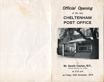 City of Moorabbin Historical Society (Operating the Box Cottage Museum)
Document - Program Official Opening Cheltenham Post Office, Government Printer, 1974
John Hitchen was the manager of the first Cheltenham Post Office that opened 1/8/1857 in a boot and shoe store. Mail was transported to and from St Kilda to Cheltenham by coach 6 days a week and an additional service twice weekly to Tootgarook via Frankston also by coach. 1868 Post office Savings Bank began operation and the Telegraph office was established at the Railway Station 1885. A new building was built 1891 in Point Nepean Road for the official Cheltenham Post Office and a new manual telephone exchange began 1899 with 24 subscribers. By 1909 100 subscribers, 1951 there were 1700 and in 1974 12,000 subscribers . Hence this new building was designed by Oscar A. T. Gimsey & Assoc. and built by T W Morris & Sons Mordialloc. Mr G Clayton Federal MP Isaacs, opened the Post Office with Moorabbin City Council Mayor C.R McHutchison, Mr WJB Pollock, Director Posts and Telegraphs, and hands the Key of the post Office to Mr L De Longville Postmaster.The Post Office was an integral part to the development and prosperity of the Cheltenham area as the area grew from pioneer settlers in the 1850's to flourishing market gardens c1900 and industrial diversity of 1974.Program for the 'Official Opening of the Cheltenham Post Office' November 29th 1974 with a black and white photo of the building.city of moorabbin, county of bourke, moorabbin roads board, parish of moorabbin, shire of moorabbin, henry dendy's special survey 1841, were j.b., bent thomas, o'shannassy john, king richard, charman s, highett william, ormond francis, maynard dennis, post office, telegraph, st kilda station, tootgarook, frankston, clayton g mhr, mchutchison r.p mayor, pollock w j b mp, market gardens, early settlers, horse coach, de longville l postmaster -
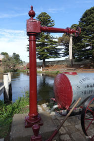 Flagstaff Hill Maritime Museum and Village
Functional object - Water standpipe, Langlands Bros. & Co, 1880-1893
This water standpipe is believed to be the only one of its kind in working order. It was originally located in Warrnambool, on the hillside at the corner of Mickle Crescent and Banyan Street, providing water for the Chinese Market Gardens below, on the flats. It was removed from this location on May 2nd, 1979, with the intention to relocate it at the new Flagstaff Hill Maritime Museum & Village. The standpipe lay in storage for years until the Warrnambool Company, Chemblast, offered to restore it for use as a working display. The display was officially opened on March 31, 2014. The water from the adjacent lake is drawn out with a hand operated water pump, and goes up into the standpipe, where flows through the canvas hose and into the top of the Furphy Farm Water Cart. The display is a visual acknowledgement of the years served by Flagstaff Hill volunteer and Friends of Flagstaff Hill Chairperson, Bob Crossman. Warrnambool’s early settlers had no water supply prior to the mid-1850s. They relied on rain water tanks, domestic wells and springs. The town experienced a huge, destructive fire in William Bateman Jnr. & Co.’s large produce store in November 1856, which highlighted the need for both a fire brigade and a good supply of water. In 1863 a volunteer fire brigade was established. In August 1880 the town celebrated the installation of its first water standpipe on the corner of Liebig and Timor streets. The water was pumped from springs at Cannon Hill through the connected pipeline to the standpipe, then distributed to households via horse and cart. Each of the licenced cart drivers were compelled by Council regulations to keep their carts full from sunset to sunrise, ready to cart water to outbreaks of fire. They received a fee for this service. In 1893 the town installed a water supply, sourced from the Merri River, stored in a reservoir basin and tower in north Liebig Street, and distributed throughout the town in a system of pipes. By late 1939 a reticulated supply was installed, with the water piped in under the Otway Scheme. Standpipes are still used in modern times in rural and remote areas for homes, farms, stock, agriculture and firefighting. Many commercial or government owned standpipes are metered, charging a fee for the quantities of water supplied. This water standpipe was made by Langlands Foundry Co. Limited, Melbourne, which was establish in 1842. It was Melbourne’s first foundry and iron shipbuilder, and one of the largest employers in Victoria at the time. Langlands was known for its high quality workmanship and wide range of goods for mining, engineering, marine, railway and other industrial uses. The company made the first cast bell, the first lamp posts in the colony, and the boiler for the first Australian train. In the 1860s it produced cast iron pipes for the Board of Works, which laid the pipes for Melbourne’s first reticulated water supply. The firm was bought by Austral Otis Co. in 1897.This water standpipe is significant historically as it is believed to be the only one of its type in working condition. The standpipe is significant for being manufactured by early colonial firm Langlands Foundry of Melbourne, which was known for high quality, cast iron products. The firm made the boiler for the first Australian train, assembled the first Australian paddle steamer and made the first Australian cast bell and lamp posts. Langlands was one of the largest employers in Victoria at the time. The standpipe is significant historically as it represents the evolution of water supply services in Australia. Standpipe; vertical cast iron water pipe, painted crimson, fixed in position, tapering inward from the round base to the rectangular joint near the finial on top. A hexagonal pipe extends at right angles from the joint, with an outlet fitting and flow-controlling wheel on the end. A length of canvas hose hangs from the outlet fitting. Inscriptions are on one face of the joint. The standpipe was made by Langlands Foundry Company of Melbourne. Embossed “LANGLANDS FOUNDRY CO. / LIMITED / ENGINEERS / MELBOURNE”warrnambool, flagstaff hill maritime museum, maritime museum, shipwreck coast, flagstaff hill maritime village, great ocean road, flagstaff hill, standpipe, stand-pipe, water standpipe, fire standpipe, firefighting equipment, water supply equipment, chinese market gardens, banyan street, liebig street, water tower, bateman’s fire, working display, water supply, town water, rural water, reticulated water, cannon hill spring, merri river, otway water, water carters, horse and cart water supply, volunteer fire brigade, langlands foundry, early melbourne, iron works, bob crossman, late 19th century water supply -
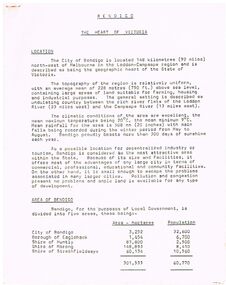 Bendigo Historical Society Inc.
Document - BENDIGO - THE HEART OF VICTORIA
Typed article titled Bendigo, The Heart of Victoria. Items mentioned are Location, Area of Bendigo, The People, Work Force, Industrial Base, natural Resources, Agriculture and Livestock, Minerals, Forests, Rail and Road, Sea and Air, Power and Water, Electricity, Natural Gas, Water, Sewerage, Industrial Land, Services, Community Services and Facilities, Educational Facilities, Hospitals, Culture and Tourism and Media.document, bendigo - the heart of victoria, city of bendigo, borough of eaglehawk, shire of huntly, shire of marong, shire of strathfieldsaye, bendigo development committee, department of agriculture, department of state development decentralization and tourism, state electricity commission, gas & fuel corporation of victoria, state rivers & water supply commission, bendigo sewerage authority, the bendigo college of advanced education, home and hospital for the aged, home for the blind, northern school of nursing, art gallery, historical society, dudley house, sun loong, central deborah gold mine, the vintage talking trams and transport museum, bcv8, the bendigo advertiser, golden city gazette, 3bo, 3cv, mr a j kelly -
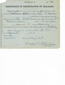 Bendigo Historical Society Inc.
Document - MCCOLL, RANKIN AND STANISTREET COLLECTION: RENT RECEIPTS, 1930/40
1. Rent receipts, permissive occupancy, Monument Hill Consolidated. 2. Right to occupy a residence area, Victoria Phillipa Evans 127 Breen Street Bendigo. 3. Plan for applied Lease 10423. 5. Certificate of Registration of tail race. Loose documents.MCCOLL RANKIN & STANISTREETorganization, business, industrial - mining, mccoll rankin & stanistreet -
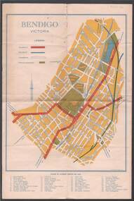 Bendigo Historical Society Inc.
Map - BILL ASHMAN COLLECTION: MAP OF BENDIGO
Map of Bendigo. Contains street of Bendigo with Places of Interest marked, Map of the Bendigo Area with Places of Interest marked, and on the centre page is Bendigo the Golden Gateway to the North. There is a map with circles around Bendigo and their distance from centre Bendigo. Circles go to a distance of 20 miles. Information includes General Information, Scenic Attractions, Industrial Activities, Industries already Established, Sporting Facilities - Bendigo and District, and Cultural Organizations. JCI shield on the left under the map. Also some brief information about Bendigo.sciences, instruments - general, scalebuoy, bill ashman collection - correspondence, map of bendigo, cambridge press, a r mcconnachie, bendigo junior chamber of commerce, bendigo city council -
Port Melbourne Historical & Preservation Society
Photograph - Various buildings, Port Melbourne, Ron Laing, 1990s
... and buildings, view from Coles parking area, Bridge Street industrial... and buildings, view from Coles parking area, Bridge Street industrial ...Part of Ron Laing's collection of photographs recording Port Melbourne over a thirteen year period. Donated to the PMH&PS by the photographer.A set of 16 colour photographs by Ron Laing covering the Herald and Weekly Times building, the ex Borer's Bakery ovens and buildings, view from Coles parking area, Bridge Street industrial medical clinic and HMAS Lonsdale building 1990sbuilt environment - commercial, built environment - civic, ron laing