Showing 124 items
matching picnic area
-
 Port of Echuca
Black and white photograph, 1920s
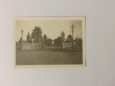
... . The Park also includes sporting grounds and facilities and picnic ...Small black and white photograph of the entrance to Victoria Park showing high iron gates that are open. The gates are open but the gate on the right is behind the fence. There are caste iron lamps at either side of the gates in front of the bowed-top picket fence. Between the gates, in the distance the fountain is visible. Murray pines are also visible. Wide dirt approach.Victoria Park is of social and historical significance to the people of Echuca and district. It includes a state park that has a natural dry schreyphyll forest with a canopy of eucalypts. The Park also includes sporting grounds and facilities and picnic areas. This photograph depicts the entrance to the Park in the 1920s showing a dirt approach with the caste iron lights, iron gates and caste iron gate posts and the bowed-top picket fence. Black and white photograph of the entrance to Victoria Park showing high iron gates and lamps with bowed-top picket fence. Wide dirt approach.On the back of photograph, in pencil, "Park Entrance"victoria park, echuca -
 Eltham District Historical Society Inc
Document - Folder, McLean, 1984-1999
References to McLean family, Hector John McLean and Louisa Frances (nee Green) and six daughters who lived in Eltham during the period 1930 to 1934 inclusive. Lived in the former Evelyn Hotel at the time it was destroyed by fire and being part of the Centenary Parade in 1934 where the family won the Group Section for their entry “Pioneers of Eltham” Reminiscences provided by Edith Jones (nee M1934 flood, ballroom, baptism, barber shop, bittern, boy scouts, bremner's flat, burgoyne's shop, cable tram, cemetery road, centenary celebrations, centenary parade, christening, coach house, collis grocery, dalton street, depression, dole, dorothy jean mclean, edith jones (nee mclean), eltham fire brigade, eltham high school, eltham higher elementary school, eltham lower park, eltham railway station, eltham state school no. 209, evelyn hotel, fire damage - buildings, flinders naval depot, fordham, gladys evelyn mclean, gold mining, gwenneth mae mclean, gwladys evelyn mclean, headmistress, hector john mclean, isherwood house and shop, louisa frances mclean (nee green), metery road, methodist church, miss finnin, miss grant cottage, motor bike races, mrs barrett, mrs bremner, mrs hurley, olive isabel mclean, parade, phoebe lillian mclean, picnic, pioneers of eltham, pitt street, research fire brigade, rev. r.g. arthur, shed, shops, st margarets church hall, st margaret's church, stables, state savings bank of victoria, susso books, todaro, vinnie willet, warrandyte bridge, warrandyte, wingrove park, yarra river -
 Eltham District Historical Society Inc
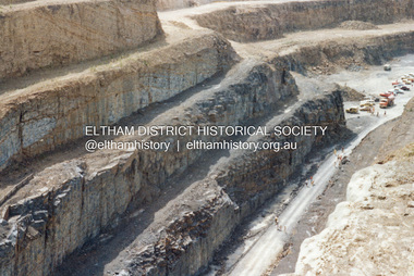
Photograph - Colour Print, Lewis Tulk, Construction Winneke Reservoir and treatment plant / Melbourne and Metropolitan Board of Works, c.1981
... northern suburbs. Within the visitor areas are two picnic grounds... northern suburbs. Within the visitor areas are two picnic grounds ...Sugarloaf Reservoir is situated on former farmland. This large water storage was completed in 1982 and serves Melbourne's northern suburbs. Within the visitor areas are two picnic grounds and other recreational facilities. Below its massive rock embankment is located the Winnecke Treatment Plan designed to purify its water before being piped into Melbourne. The dam partly inundated the old firing ranges of the former Christmas Hills Rifle Club. Source: Christmas Hills Now and then: Yarra Glen & District Historical Society, 2004.lewis tulk collection, construction, sugarloaf reservoir, winnecke dam -
 Eltham District Historical Society Inc
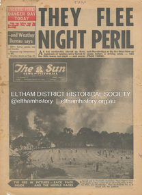
Newspaper - Newspaper articles, Sun News-Pictorial, They Flee Night Peril, The Sun News-Pictorial, Wednesday, January 17, p1, 1962
Various news articles pertaining to the January 1962 Victorian bushfires in the Dandenong and Healesville districts which by the third day had encompassed large areas of the State. Specific Eltham Shire districts mentioned include Panton Hill and Hurstbridge on page 1, Warrandyte on page 2, 3, 4 and 5, Hurstbridge, Smith’s Gully, Kinglake on page 3 and 4, Strathewen, Kangaroo Ground, Panton Hill, St. Andrews, Smith’s Gully on page 4 and Pound Bend, Smith’s Gully and Warrandyte on pages 20-21 • They Flee Night Peril, p1 (Illust.) • Their grim picnic; A flash fire strikes, p2 (Illust.) • Night of terror as towns quitted, p3 • Fought till he dropped, p3 (Illust.) • Rain in fire area, p3 • Wye River town goes, p3 • Black Friday Hero Dies In Fire; with wife, grandsons, p4 • Surrounded!, p4 (Illust.) • Main street houses ablaze, p4 • Hurstbridge is evacuated, p4 • Scores jump in river at Warrandyte, p5 • Hills people leave homes, p5 • “Fire” cry at Parlt., p5 • Blind – he’s safe now, p5 (Illust.) • Police Chief Runs Battle, p7 • From Fire Front: Hospital treats 34, p7 • Firms send help, p7 • Tragedy and Ruin: Third Day; Ferntree Gully; Warrandyte; Pound Bend; Smiths Gully; Escape for 18, pp20-21 (Illust.) • Church was a haven for the hurt, weary, p39 (Illust.) • A home is lost, p40 (Illust.) tom fielding collection, victorian bushfires - 1962, victorian bushfires – 1962, panton hill, hurstbridge, five ways crossroads, warrandyte south, dandenongs, upwey, mt. evelyn, monbulk, olinda, sassafras, st. andrews, warrandyte, christmas hills, yarra river, mitcham, whitehorse roiad, donvale, park orchards, metropolitan fire chief, w.t. aldridge, loughnan’s hill, ringwood, woori yallock, leslie ockwell, linda ockwell, kalorama, healesville, daylesford, fire damage – buildings, wye river, portland, eganstown, ballarat, sherbrooke park forest, forest commission headquarters, kallista, r.t. seaton, montrose, yallourn, central gippsland, smith’s creek, black friday, geoffrey ockwell, ronald ockwell, preston town hall, e.j. tenner, strathewen, kangaroo ground, eric farnsworth, adele farnsworth, robin farnsworth, roy cleland, ann cleland, belgrave, sassfras, kaloramalice commissioner porter, mansfield, box hill hospital, pound bend, ferntree gully, ferntree gully state school, w. carew, ann quinton -
 Eltham District Historical Society Inc
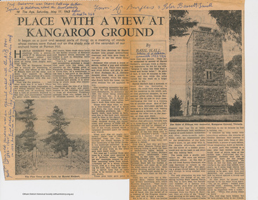
Folder, Basil Hall, 1999
Original newspaper article from "The Age" May 11, 1963. Place with a view at Kangaroo Ground by Basil Hall about the construction of the War memorial. The Hall family resided at "Fairview" Panton Hill in the 1920s. Hall was a Eltham Shire Councilor in the 1920s and was associated with the Eltham Shire war Memorial Tower Bulding Committee from 1924 to 1926. Photocopies from "The Road to Gundagi" by Graham McInnes (Hamish Hamilton, 1965), Chapter 9 pages 132 - 153 an autobiography in which the author reminiscences about visiting the Hall family at "Fairview" in Panton Hill as a child. References also to Watson's Creek where MacPherson Robertson ("The Chocolate King") had a summer home, the Shannons, Shanhun and McLaughlin familes. Includes description of the day that Hurstbridge was declared a township (May 26th, 1924), a ralway journey, picnics and rabbiting. McInnes' reminiscences about the periods of his childhood spent visiitng the Hall family in Panton Hill in the 1920s are a rare first hand glimpse into the recreational, social and municipal life in the 1920s within the this rural area within the Shire of Eltham. "Road to Gundagi" was the first of three widely acclaimed autobiographies.Original newspaper article Photocopies, 12 pages.HG Booklet 36basil hall, click here to add keywords, cr. basil hall, eltham war memorial, graham mcinnes, harry gilham collection, hurstbridge, kangaroo ground tower building committee, macpherson robertson, mclaughlin family, panton hill, picnicing, rabbiting, reminiscences, shanhun family, shannon family, shire of eltham war memorial, war memorial tower, watson's creek -
 Eltham District Historical Society Inc
Book, Percy Leason: an artist's life by Margot Tasca, 2016
"Who would have thought that a boy born in 1889 from the Victorian Mallee would become a successful artist on New York’s Staten Island? This finely illustrated, exhaustively researched and beautifully written biography on Leason features the artist’s entire career as a painter and cartoonist renowned for his depictions of Australian society in the 1920s and 1930s. Leason’s story is a poignant one tracing his beginnings as a cartoonist, to the bohemian Melbourne art scene in the early 20th century, to his involvement in the artists’ camps of Eltham, to his important series of portraits of Lake Tyers Indigenous Australians, and his eventual move to the US where he has been acknowledged as making an enormous contribution to the New York arts scene. This story, as yet untold, fills a gap in the history of art in Australia and offers a new perspective on Australian art in the first half of the 20th century." - Thames and Hudson website A NEW HOME IN ELTHAM Once they had settled back into Melbourne, Perry and Belle began to look for a place to make a permanent home. Having enjoyed the bush setting of Mosman, they decided to explore the rural fringes of Melbourne. Each weekend they packed a picnic and travelled to the towns in the nearby hills - such as Ferntree Gully, Sassafras, Lilydale and, of course, Cockatoo Creek. Eventually deciding these places might be a little too far from The Herald office, they searched closer to the city. The Heidelberg and Box Hill regions that had inspired his old teacher McCubbin, had become busy, urban areas but further east, towards Warrandyte and Templestowe, there were still large tracts of bush. Finally they settled on Eltham, an area Percy knew very well, having often painted there with Jock Frater. Perry's old friend Dick McCann and his wife Margery had also settled in Eltham. The township was fifteen miles from Melbourne and serviced by an electric train that went to the central Melbourne station of Flinders Street, near where The Herald offices were located. Eltham was a small village in 1925, separated from Melbourne by the Yarra River, and surrounded by orchards and large tracts of bush. Small farms dotted the landscape and the main businesses revolved around ironmongers, blacksmiths, and farming supplies. Of particular appeal to artists was Eltham Park, a large expanse of bushland bounded by the Yarra River on the south side and the Diamond Creek on the east. The park included a playing field that was busy on weekends with cricket or football matches, but for the rest of the week it was mostly empty and an ideal place to paint. The scenery there provided the inspiration for many paintings by Leason, Meldrum and other artists such as Colin Colahan and Peter (A.E.) Newburv. The Leasons found a rundown old farmhouse on four-and-a-half acres of land in New Street, now known as Lavender Park Road. The site was splendid, at the top of a gentle slope which gave panoramic views east to the Dandenong hills, south over the Templestowe orchards and north to Kinglake. The front lawn was taken over by onion grass (or wiregrass as Leason called it) and scattered about the property were many wattles and gum trees. Aloe cacti covered much to the front of the house, while old quince and lucerne hedges separated the house and out-buildings from a rundown apple orchard. Here they would build a new home. ·with financial assistance from The Herald, Leason bought the property and immediately commissioned an architectural firm to design a new house in the popular bungalow style of the time. The old farm house was demolished but Percy saved the siding boards, bricks and corrugated iron for the outbuildings of his new home. The new house was a two storey, triple brick with a large, gabled, terracotta tiled roof. It was situated at the very top of the slope. The paint and varnish were barely dry when the family moved in during the summer of 1925-26 and the fumes were overpowering in the heat. Despite the house being wired for electricity, power poles had not yet reached the area and initially the family had to rely on kerosene lamps and candles. When electricity did arrive, Leason reflected on the community's reception of electricity at the expense of the old growth gum tree corridors in his cartoon, Electricity comes to Wiregrass. The family had now grown to seven. Jack was nearly nine, Jean was seven, Marjory was four, Nancy was two and the baby Patricia was seven months old. Jack and Jean were enrolled in the local primary school down the hill. A retired farmer, Jock McMillan, came to live on the property and help out with the general maintenance. Jock built himself a shack and Belle provided him with meals. He was kept occupied building structures around the property·, such as the garage, the outside toilet, garden beds, trellis arbours and a number of ponds. The elderly, bearded Scotsman with his old hat and baggy pants also provided the inspiration for one of the characters Leason regularly included in his cartoons. Like Leason, Jock smoked a straight stemmed pipe. A neighbour was employed to help Belle with domestic chores, and so the family settled down to live comfortably in their new Eltham house. Two dogs, Maginary and Wodger, completed the large and vibrant household. “Percy Leason; an artist’s life” by Margot Tasca, Thames & Hudson Australia Pty Ltd, Port Melbourne 2016, pp 63-64 Hardback Bookpercy leason, margot tasca, biography, artist, landscape -
 Flagstaff Hill Maritime Museum and Village
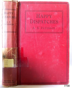
Book, Happy Dispatches
This item is from the ‘Pattison Collection’, a collection of books and records that was originally owned by the Warrnambool Mechanics’ Institute, which was founded in Warrnambool in 1853. By 1886 the Warrnambool Mechanics’ Institute (WMI) had grown to have a Library, Museum and Fine Arts Gallery, with a collection of “… choice productions of art, and valuable specimens in almost every branch and many wonderful national curiosities are now to be seen there, including historic relics of the town and district.” It later included a School of Design. Although it was very well patronised, the lack of financial support led the WMI in 1911 to ask the City Council to take it over. In 1935 Ralph Pattison was appointed as City Librarian to establish and organise the Warrnambool Library as it was then called. When the WMI building was pulled down in 1963 a new civic building was erected on the site and the new Warrnambool Library, on behalf of the City Council, took over all the holdings of the WMI. At this time some of the items were separated and identified as the ‘Pattison Collection’, named after Ralph Pattison. Eventually the components of the WMI were distributed from the Warrnambool Library to various places, including the Art Gallery, Historical Society and Flagstaff Hill. Later some were even distributed to other regional branches of Corangamite Regional Library and passed to and fro. It is difficult now to trace just where all of the items have ended up. The books at Flagstaff Hill Maritime Village generally display stamps and markings from Pattison as well as a variety of other institutions including the Mechanics’ Institute itself. RALPH ERIC PATTISON Ralph Eric Pattison was born in Rockhampton, Queensland, in 1891. He married Maude Swan from Warrnambool in 1920 and they set up home in Warrnambool. In 1935 Pattison accepted a position as City Librarian for the Warrnambool City Council. His huge challenge was to make a functional library within two rooms of the Mechanics’ Institute. He tirelessly cleaned, cleared and sorted a disarrayed collection of old books, jars of preserved specimens and other items reserved for exhibition in the city’s museum. He developed and updated the library with a wide variety of books for all tastes, including reference books for students; a difficult task to fulfil during the years following the Depression. He converted all of the lower area of the building into a library, reference room and reading room for members and the public. The books were sorted and stored using a cataloguing and card index system that he had developed himself. He also prepared the upper floor of the building and established the Art Gallery and later the Museum, a place to exhibit the many old relics that had been stored for years for this purpose. One of the treasures he found was a beautiful ancient clock, which he repaired, restored and enjoyed using in his office during the years of his service there. Ralph Pattison was described as “a meticulous gentleman whose punctuality, floorless courtesy and distinctive neat dress were hallmarks of his character, and ‘his’ clock controlled his daily routine, and his opening and closing of the library’s large heavy doors to the minute.” Pattison took leave during 1942 to 1945 to serve in the Royal Australian Navy, Volunteer Reserve as Lieutenant. A few years later he converted one of the Museum’s rooms into a Children’s Library, stocking it with suitable books for the younger generation. This was an instant success. In the 1950’s he had the honour of being appointed to the Victorian Library Board and received more inspiration from the monthly conferences in Melbourne. He was sadly retired in 1959 after over 23 years of service, due to the fact that he had gone over the working age of council officers. However he continued to take a very keen interest in the continual development of the Library until his death in 1969. About A. B. ‘Banjo’ Paterson Andrew Barton Paterson was born at Narrambla Station in New South Wales, Australia, on 17th February 1864 and died 5th February 1941. His first seven years were spent on his father’s station, where like so many Australian children he enjoyed a bush boyhood. This property was at Obley in the Orange district of New South Wales. The family moved to the Yass district and lived near the main route from Sydney to Melbourne where he saw a great many bullock teams, drovers with herds of stock, gold escorts and Cob & Co coaches. His lifelong love of horses and horsemen was forged from the riders and their horses he saw at the picnic races and polo matches the family attended. These horses and riders where from the Murrumbidgee River and Snowy Mountain areas of New South Wales. Patterson lived most of his life in Sydney. He became a journalist, army officer, novelist, poet, solicitor and a war correspondent. He enjoyed many different sports such as tennis, rowing and, most of all, he delighted in his horsemanship. His first poem ‘El Mahdi to the Australian Troop’ was published in the Bulletin in 1885 under the pen name of “The Banjo”, which was the name of his favourite horse. In 1895 his first book was published and was sold out in the week of publication; he sold 7000 copies in a few months. This book was “The Man From Snowy River, and other Verses” and it contained such ballads as ‘Clancy of the Overflow’, ‘The Geebung Polo Club’, ‘The Man from Ironbark’, and ‘Saltbush Bill’. The tittle poem was first published in 1890. In 1895 Patterson visited his fiancé (at that time), Sarah Riley, who was staying with her friends the Macphersons at Dagworth Station in Queensland. Sarah’s old school friend Christina McPherson. Christina replayed to them an old Scottish tune called “The Craigielee March” that she had heard played by the Garrison Artillery band at the Warrnambool picnic races in Victoria, 1894. Patterson wrote words to fit the tune and it became the now famous ‘Waltzing Matilda’. He was commissioned by the Sydney Morning Herald and the Melbourne Age as they correspondent to report on the South African War. After being a roving reporter in China he went to England and spent time with Rudyard Kipling. In April 1903 Paterson married Alice Walker in Tenterfield, New South Wales, and they had two children, Grace and Hugh. At the outbreak of World War 1 Paterson sailed for England in the hope of covering the fighting in Flanders as a correspondent but finished up driving an ambulance for the Australian Voluntary Hospital, Wimereux, France. In 1915 as an honorary vet he made three voyages taking horse to Africa, China and Egypt. On 18th October 1915 he was commissioned in the 2nd Remount Unit in the Australian Imperial Force and was promoted to Captain serving in the Middle East. He was wounded in April 1916, when he re-joined his unit he was promoted to major and commanded the Australian Remount Squadron from October 1916 to his return to Australia in 1919. Once the War was over he resumed his work as a journalist until he retired in 1930 so that he could devote time to creative writing. He became a successful radio broadcaster with the Australian Broadcasting Commission using his travel experiences. He wrote the children’s book “The Animals Noah Forgot” in 1933 and then in 1934 “Happy Dispatches” in which he told of his meetings with people like Winston Churchill and Kipling. “The Shearer’s Colt was published in 1936 and in 1939 he wrote for the Sydney Morning Herald. After a short illness he passed away in Sydney on 5th February 1941. The Pattison Collection, along with other items at Flagstaff Hill Maritime Village, was originally part of the Warrnambool Mechanics' Institute’s collection. The Warrnambool Mechanics’ Institute Collection is primarily significant in its totality, rather than for the individual objects it contains. Its contents are highly representative of the development of Mechanics' Institute libraries across Australia, particularly Victoria. A diversity of publications and themes has been amassed, and these provide clues to our understanding of the nature of and changes in the reading habits of Victorians from the 1850s to the middle of the 20th century. The collection also highlights the Warrnambool community’s commitment to the Mechanics’ Institute, reading, literacy and learning in the regions, and proves that access to knowledge was not impeded by distance. These items help to provide a more complete picture of our community’s ideals and aspirations. The Warrnambool Mechanics Institute book collection has historical and social significance for its strong association with the Mechanics Institute movement and the important role it played in the intellectual, cultural and social development of people throughout the latter part of the nineteenth century and the early twentieth century. The collection of books is a rare example of an early lending library and its significance is enhanced by the survival of an original collection of many volumes. The Warrnambool Mechanics' Institute’s publication collection is of both local and state significance. Happy Dispatches Author: A B ("Banjo") Paterson Publisher: Angus & Robertson Ltd Date: 1935Label on spine cover with typed text PAT 920 PAT Pastedown front endpaper has sticker from Warrnambool Public Library covered by a sticker from Corangamite Regional Library Service Front loose endpaper has a stamp from Corangamite Regional Library Service warrnambool, shipwrecked-coast, flagstaff-hill, flagstaff-hill-maritime-museum, maritime-museum, shipwreck-coast, flagstaff-hill-maritime-village, shipwrecked-artefact, book, pattison collection, warrnambool library, warrnambool mechanics’ institute, ralph eric pattison, corangamite regional library service, warrnambool city librarian, mechanics’ institute library, victorian library board, warrnambool books and records, warrnambool children’s library, great ocean road, happy dispatches, a b paterson, banjo paterson -
 Flagstaff Hill Maritime Museum and Village
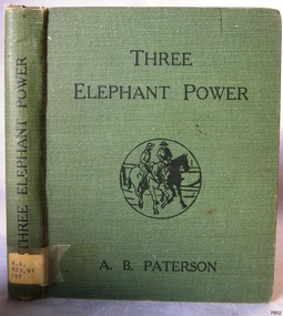
Book, Three Elephant Power
This item is from the ‘Pattison Collection’, a collection of books and records that was originally owned by the Warrnambool Mechanics’ Institute, which was founded in Warrnambool in 1853. By 1886 the Warrnambool Mechanics’ Institute (WMI) had grown to have a Library, Museum and Fine Arts Gallery, with a collection of “… choice productions of art, and valuable specimens in almost every branch and many wonderful national curiosities are now to be seen there, including historic relics of the town and district.” It later included a School of Design. Although it was very well patronised, the lack of financial support led the WMI in 1911 to ask the City Council to take it over. In 1935 Ralph Pattison was appointed as City Librarian to establish and organise the Warrnambool Library as it was then called. When the WMI building was pulled down in 1963 a new civic building was erected on the site and the new Warrnambool Library, on behalf of the City Council, took over all the holdings of the WMI. At this time some of the items were separated and identified as the ‘Pattison Collection’, named after Ralph Pattison. Eventually the components of the WMI were distributed from the Warrnambool Library to various places, including the Art Gallery, Historical Society and Flagstaff Hill. Later some were even distributed to other regional branches of Corangamite Regional Library and passed to and fro. It is difficult now to trace just where all of the items have ended up. The books at Flagstaff Hill Maritime Village generally display stamps and markings from Pattison as well as a variety of other institutions including the Mechanics’ Institute itself. RALPH ERIC PATTISON Ralph Eric Pattison was born in Rockhampton, Queensland, in 1891. He married Maude Swan from Warrnambool in 1920 and they set up home in Warrnambool. In 1935 Pattison accepted a position as City Librarian for the Warrnambool City Council. His huge challenge was to make a functional library within two rooms of the Mechanics’ Institute. He tirelessly cleaned, cleared and sorted a disarrayed collection of old books, jars of preserved specimens and other items reserved for exhibition in the city’s museum. He developed and updated the library with a wide variety of books for all tastes, including reference books for students; a difficult task to fulfil during the years following the Depression. He converted all of the lower area of the building into a library, reference room and reading room for members and the public. The books were sorted and stored using a cataloguing and card index system that he had developed himself. He also prepared the upper floor of the building and established the Art Gallery and later the Museum, a place to exhibit the many old relics that had been stored for years for this purpose. One of the treasures he found was a beautiful ancient clock, which he repaired, restored and enjoyed using in his office during the years of his service there. Ralph Pattison was described as “a meticulous gentleman whose punctuality, floorless courtesy and distinctive neat dress were hallmarks of his character, and ‘his’ clock controlled his daily routine, and his opening and closing of the library’s large heavy doors to the minute.” Pattison took leave during 1942 to 1945 to serve in the Royal Australian Navy, Volunteer Reserve as Lieutenant. A few years later he converted one of the Museum’s rooms into a Children’s Library, stocking it with suitable books for the younger generation. This was an instant success. In the 1950’s he had the honour of being appointed to the Victorian Library Board and received more inspiration from the monthly conferences in Melbourne. He was sadly retired in 1959 after over 23 years of service, due to the fact that he had gone over the working age of council officers. However he continued to take a very keen interest in the continual development of the Library until his death in 1969. About A. B. ‘Banjo’ Paterson Andrew Barton Paterson was born at Narrambla Station in New South Wales, Australia, on 17th February 1864 and died 5th February 1941. His first seven years were spent on his father’s station, where like so many Australian children he enjoyed a bush boyhood. This property was at Obley in the Orange district of New South Wales. The family moved to the Yass district and lived near the main route from Sydney to Melbourne where he saw a great many bullock teams, drovers with herds of stock, gold escorts and Cob & Co coaches. His lifelong love of horses and horsemen was forged from the riders and their horses he saw at the picnic races and polo matches the family attended. These horses and riders where from the Murrumbidgee River and Snowy Mountain areas of New South Wales. Patterson lived most of his life in Sydney. He became a journalist, army officer, novelist, poet, solicitor and a war correspondent. He enjoyed many different sports such as tennis, rowing and, most of all, he delighted in his horsemanship. His first poem ‘El Mahdi to the Australian Troop’ was published in the Bulletin in 1885 under the pen name of “The Banjo”, which was the name of his favourite horse. In 1895 his first book was published and was sold out in the week of publication; he sold 7000 copies in a few months. This book was “The Man From Snowy River, and other Verses” and it contained such ballads as ‘Clancy of the Overflow’, ‘The Geebung Polo Club’, ‘The Man from Ironbark’, and ‘Saltbush Bill’. The tittle poem was first published in 1890. In 1895 Patterson visited his fiancé (at that time), Sarah Riley, who was staying with her friends the Macphersons at Dagworth Station in Queensland. Sarah’s old school friend Christina McPherson. Christina replayed to them an old Scottish tune called “The Craigielee March” that she had heard played by the Garrison Artillery band at the Warrnambool picnic races in Victoria, 1894. Patterson wrote words to fit the tune and it became the now famous ‘Waltzing Matilda’. He was commissioned by the Sydney Morning Herald and the Melbourne Age as they correspondent to report on the South African War. After being a roving reporter in China he went to England and spent time with Rudyard Kipling. In April 1903 Paterson married Alice Walker in Tenterfield, New South Wales, and they had two children, Grace and Hugh. At the outbreak of World War 1 Paterson sailed for England in the hope of covering the fighting in Flanders as a correspondent but finished up driving an ambulance for the Australian Voluntary Hospital, Wimereux, France. In 1915 as an honorary vet he made three voyages taking horse to Africa, China and Egypt. On 18th October 1915 he was commissioned in the 2nd Remount Unit in the Australian Imperial Force and was promoted to Captain serving in the Middle East. He was wounded in April 1916, when he re-joined his unit he was promoted to major and commanded the Australian Remount Squadron from October 1916 to his return to Australia in 1919. Once the War was over he resumed his work as a journalist until he retired in 1930 so that he could devote time to creative writing. He became a successful radio broadcaster with the Australian Broadcasting Commission using his travel experiences. He wrote the children’s book “The Animals Noah Forgot” in 1933 and then in 1934 “Happy Dispatches” in which he told of his meetings with people like Winston Churchill and Kipling. “The Shearer’s Colt was published in 1936 and in 1939 he wrote for the Sydney Morning Herald. After a short illness he passed away in Sydney on 5th February 1941. The Pattison Collection, along with other items at Flagstaff Hill Maritime Village, was originally part of the Warrnambool Mechanics' Institute’s collection. The Warrnambool Mechanics’ Institute Collection is primarily significant in its totality, rather than for the individual objects it contains. Its contents are highly representative of the development of Mechanics' Institute libraries across Australia, particularly Victoria. A diversity of publications and themes has been amassed, and these provide clues to our understanding of the nature of and changes in the reading habits of Victorians from the 1850s to the middle of the 20th century. The collection also highlights the Warrnambool community’s commitment to the Mechanics’ Institute, reading, literacy and learning in the regions, and proves that access to knowledge was not impeded by distance. These items help to provide a more complete picture of our community’s ideals and aspirations. The Warrnambool Mechanics Institute book collection has historical and social significance for its strong association with the Mechanics Institute movement and the important role it played in the intellectual, cultural and social development of people throughout the latter part of the nineteenth century and the early twentieth century. The collection of books is a rare example of an early lending library and its significance is enhanced by the survival of an original collection of many volumes. The Warrnambool Mechanics' Institute’s publication collection is of both local and state significance. Three Elephant Power Author: A B Paterson Publisher: Angus & Robertson Date: 1917Label on spine cover with typed text RA 823.91 PAT Pastedown front endpaper has sticker from Warrnambool Mechanics Institute and Free Library Front loose endpaper has a stamp from Warrnambool Mechanics Institute Fly paper has a stamp from Warrnambool Mechanics Institutewarrnambool, shipwrecked-coast, flagstaff-hill, flagstaff-hill-maritime-museum, maritime-museum, shipwreck-coast, flagstaff-hill-maritime-village, shipwrecked-artefact, book, pattison collection, warrnambool library, warrnambool mechanics’ institute, ralph eric pattison, corangamite regional library service, warrnambool city librarian, mechanics’ institute library, victorian library board, warrnambool books and records, warrnambool children’s library, great ocean road, three elephant power, a b paterson -
 Phillip Island and District Historical Society Inc.
Photograph, c 1900
Rural scene in San Remo area. Cows grazing with cart horses in background. Beautiful trees, large gathering of people of all ages in their Sunday-best clothing, hats and umbrellas as protection from the sun. Butter churns in foreground. Anderson property - "Netherwood"Picnic gathering beneath large trees - rural setting at Anderson' home "Netherwood"local history, photography, photographs, slides, film, picnic gathering, sepia photograph, miss elms, san remo, anderson property netherwood -
 Greensborough Historical Society
Slide - Photograph, John Ramsdale, Car park on Kurrak Road Yarrambat: Slide 45, 1990s
Photograph shows a park and carparking area with people sitting at picnic table, Middle Gorge Park, Yarrambat.Part of the John Ramsdale collection of slides and audio visual material.Colour photograph scanned from slide.No maker's marks. No caption on slide.middle gorge park, yarrambat, kurrak road yarrambat -
 Greensborough Historical Society
Photograph, North Melbourne Metro Ice Works Picnic in Greensborough, 1908c
North Melbourne Metro Ice Works Picnic at Greensborough Circa 1908. From the Alexander Family showing John Senior, Isabella, Baby Henry, John Junior, Marcella Evans.Representative photograph of a group picnic held in the Greensborough area, a popular venue and day trip for groups from Melbourne.Black and White PhotographBack Sticker States - North Melbourne Metro Ice Works Picnic at Greensborough Circa 1908 The Alexander Family - John [Senior], Isabella, Baby Henry, John [Junior], Marcella Evans.alexander family -
Glenelg Shire Council Cultural Collection
Photograph - Photograph - Picnic Scene, n.d
Black and white photo taken from glass plate negative. Attached to heavy card, showing a large group of men and women picnicking on grassy area, in front of trees. Estimated by dress to be of the late 19th, early 20th Century. -
 Halls Gap & Grampians Historical Society
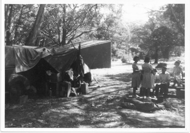
Photograph - B/W, C 1940s
This is a photo of the Zumsteins camping area, which was popular with families.The photo shows a group of six people, two standing near, and four seated at, a picnic table. There is a large canvas tent/structure with boxes and tins at the entrance to the left and behind it there is a corrugated iron building. The area is surrounded by bush.recreation, camping, scenery, zumsteins -
 Ararat & District Historical Society (operating the Langi Morgala Museum)
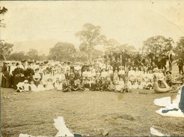
Photograph, Maker not known, 1904
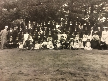
This is a photo of a very large group of people at the Langi Ghiran Picnic Grounds in 1904. The photo provides information about leisure wear and leisure activities in the Ararat area at this time. This photo is of local significance (Langi Ghiran and the Ararat district). Although the photo is physically damaged, the detail in most of the photo is still very clear, giving information on clothing and leisure activities. The fact that the date and the donor are known adds to its significance.Black and white photograph mounted on cardboard of a formal group of approximately 110 men, women and children gathered in a rural setting, standing and seated, with trees in the background. The photograph is torn away in several places"Picnic Grounds / Langi Gherin1904".clothing, leisure, 1904, picnic, leisure-activities, picnickers, photograph, langi morgala, ararat, langi ghiran -
 Eltham District Historical Society Inc
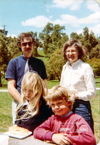
Photograph, Gavin Phillips and Anne Wilson with Fiona and Matthew at the end of year picnic, Eltham Christian School, 1983, 1983
Gavin Phillips and Anne Wilson with Fiona and Matthew at the end of year picnic, Eltham Christian School, 1983 The Stokes family settled in this area of Eltham in the 1940s and were associated with the Eltham Christian Church. In the 1970s this church had met in temporary premises in Eltham. Lots of the original 1920s subdivision remained south of Nyora Road and a number of these lots were utilized for the Eltham Christian School, which was established by the Eltham Christian Church in 1981. The school operated on this site until 2000. The premises were owned by the Nillumbik Community Church who were in operation till November 2010 when the Eltham Baptist Church commenced a lease arrangement until the site was purchased by them in April 2012. The building is constructed of brick and timber with a balcony on two sides that looks over an expanse of grass. Sources: STOKES ORCHARD – AN INCOMPLETE HISTORY February 28, 2015 http://www.elthamhistory.org.au/ Australian Christian Church Histories - Eltham Baptist Church http://www.churchhistories.net.au/church-catalog/eltham-vic-baptist/ From a magnetic spiral bound photo album featuring a series of photographs (some cropped) with captions relating to the staff, students and activities of the Eltham Christian School which operated as part of the Eltham Christian Church at Nyora Road, Eltham. See also entries for each photograph.colour photographeltham christian school, nyora road, gavin phillips, anne wilson -
 Eltham District Historical Society Inc
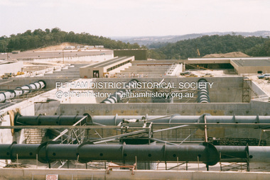
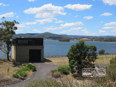
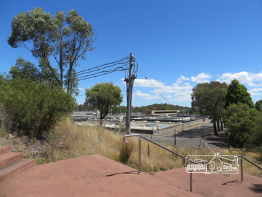
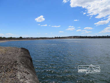
Photograph, Sugarloaf Reservoir, Christmas Hills, 16 January 2015, 16 January 2015
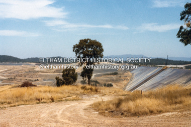
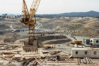
... northern suburbs. Within the visitor areas are two picnic grounds... northern suburbs. Within the visitor areas are two picnic grounds ...Sugarloaf Reservoir is situated on former farmland. This large water storage was completed in 1982 and serves Melbourne's northern suburbs. Within the visitor areas are two picnic grounds and other recreational facilities. Below its massive rock embankment is located the Winnecke Treatment Plan designed to purify its water before being piped into Melbourne. The dam partly inundated the old firing ranges of the former Christmas Hills Rifle Club. Source: Christmas Hills Now and then: Yarra Glen & District Historical Society, 2004. Born Digitalchristmas hills, sugarloaf reservoir -
 Eltham District Historical Society Inc
Photograph, Sugarloaf Reservoir, Christmas Hills, 16 January 2015, 16 January 2015
... northern suburbs. Within the visitor areas are two picnic grounds... northern suburbs. Within the visitor areas are two picnic grounds ...Sugarloaf Reservoir is situated on former farmland. This large water storage was completed in 1982 and serves Melbourne's northern suburbs. Within the visitor areas are two picnic grounds and other recreational facilities. Below its massive rock embankment is located the Winnecke Treatment Plan designed to purify its water before being piped into Melbourne. The dam partly inundated the old firing ranges of the former Christmas Hills Rifle Club. Source: Christmas Hills Now and then: Yarra Glen & District Historical Society, 2004. Born Digitalchristmas hills, sugarloaf reservoir -
 Eltham District Historical Society Inc
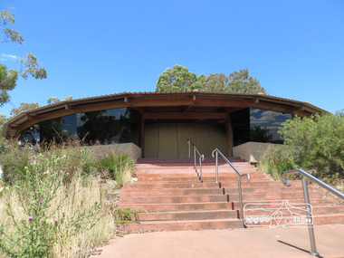
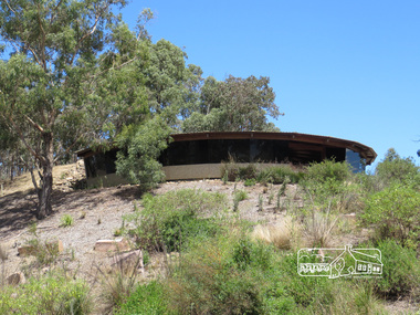
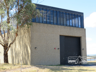
Photograph, Sugarloaf Reservoir, Christmas Hills, 16 January 2015, 16 January 2015
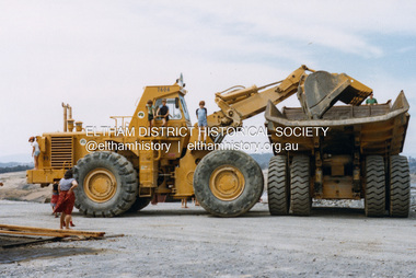
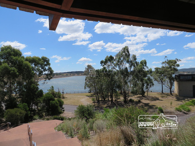
... and serves Melbourne's northern suburbs. Within the visitor areas... and serves Melbourne's northern suburbs. Within the visitor areas ...Structure at Sugarloaf. Sugarloaf Reservoir is situated on former farmland. This large water storage was completed in 1982 and serves Melbourne's northern suburbs. Within the visitor areas are two picnic grounds and other recreational facilities. Below its massive rock embankment is located the Winnecke Treatment Plan designed to purify its water before being piped into Melbourne. The dam partly inundated the old firing ranges of the former Christmas Hills Rifle Club. Source: Christmas Hills Now and then: Yarra Glen & District Historical Society, 2004. Born Digitalchristmas hills, sugarloaf reservoir -
 Eltham District Historical Society Inc
Photograph, Sugarloaf Reservoir, Christmas Hills, 16 January 2015, 16 January 2015
... northern suburbs. Within the visitor areas are two picnic grounds... northern suburbs. Within the visitor areas are two picnic grounds ...Sugarloaf Reservoir is situated on former farmland. This large water storage was completed in 1982 and serves Melbourne's northern suburbs. Within the visitor areas are two picnic grounds and other recreational facilities. Below its massive rock embankment is located the Winnecke Treatment Plan designed to purify its water before being piped into Melbourne. The dam partly inundated the old firing ranges of the former Christmas Hills Rifle Club. Source: Christmas Hills Now and then: Yarra Glen & District Historical Society, 2004. Born Digitalchristmas hills, sugarloaf reservoir -
 Eltham District Historical Society Inc
Photograph, Sugarloaf Reservoir, Christmas Hills, 16 January 2015, 16 January 2015
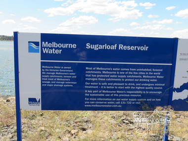
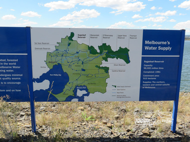
... northern suburbs. Within the visitor areas are two picnic grounds... northern suburbs. Within the visitor areas are two picnic grounds ...Sugarloaf Reservoir is situated on former farmland. This large water storage was completed in 1982 and serves Melbourne's northern suburbs. Within the visitor areas are two picnic grounds and other recreational facilities. Below its massive rock embankment is located the Winnecke Treatment Plan designed to purify its water before being piped into Melbourne. The dam partly inundated the old firing ranges of the former Christmas Hills Rifle Club. Source: Christmas Hills Now and then: Yarra Glen & District Historical Society, 2004. Born DigitalMelbourne Water Sugarload reservoir Melboure Water is owned by the Victorian Government. We manage Melbourne's water supply catchments, remove and treat most of Melbourne's sewrage, and manage waterways and major drainage systems. Most of Melbourne's water comes from uninhabited, forested catchments. Melbourne is one of the few cities in the world that has protecyed water supply catchments. Melbourne Water manages these catchments to protect our drinking water. Our water is safe and pleasant to drink, and undergoes minimal treatment - it is better to start witht he highest quality source. A key part of Melbourne Water's responsibility is to encourage the sustainable use of this precious resource. For more inforamtio on our water supply and on how you can conserve water, call 131 722 or visit www.melbournewater.com.auchristmas hills, sugarloaf reservoir, sign, melbourne water -
 Eltham District Historical Society Inc
Photograph, Sugarloaf Reservoir, Christmas Hills, 16 January 2015, 16 January 2015
... northern suburbs. Within the visitor areas are two picnic grounds... northern suburbs. Within the visitor areas are two picnic grounds ...Sugarloaf Reservoir is situated on former farmland. This large water storage was completed in 1982 and serves Melbourne's northern suburbs. Within the visitor areas are two picnic grounds and other recreational facilities. Below its massive rock embankment is located the Winnecke Treatment Plan designed to purify its water before being piped into Melbourne. The dam partly inundated the old firing ranges of the former Christmas Hills Rifle Club. Source: Christmas Hills Now and then: Yarra Glen & District Historical Society, 2004. Born Digitalchristmas hills, sugarloaf reservoir, signage -
 Kiewa Valley Historical Society
Photograph of Lake Guy and Bogong Village, Lake Guy and Bogong Village, Approx. 1945
... they were removed and the site converted into a public picnic area ...In 1940 Field Headquarters for the Kiewa Scheme were established at Bogong with office, workshop facilities and accommodation for workmen, staff and some families constructed. (There had been a 'tent camp' on this site in 1939 but was destroyed by bushfires) Construction of accommodation continued until 1947. A total of 40 houses plus a hostel for single staff, post office, police station, medical centre and primary school all with water and sewerage and electricity supply. The staff hostel was known as Kiewa House and is now occupied by the Education Department. Lake Guy was named after Mr. L.T. Guy who was the Resident Engineer in charge of construction work and associated activities on the Kiewa area. He held this position from 1939 to November 1946 when he was transferred to Head Office.This photograph is an excellent historical record of Bogong Village in about 1945. It shows the layout of the town in the fairly steep terrain, the workmen's camp between the houses and the lake foreshore, the Commissioner's Lodge on the hill behind the Village, the walkway through the dam wall can be seen to the left of the spillway, the dam is on spill and note damage to the large trees is still evident from the 1939 bush fires. The Commissioner's Lodge was lost in the 2003 fires and the camp buildings were in service until 1962, when they were removed and the site converted into a public picnic area with lawns and gardens.A Black and white photograph"Lake Guy and Bogong" hand written on back of photograph.kiewa, accommodation, lake, dam, bogong -
 Eltham District Historical Society Inc
Photograph, Fred Kruger, View near the Plenty Mountains. Children's Picnic, 1880
... areas plenty river Picnic Digital image, 18.5 x 25 cm print ...This photo forms part of a collection of photographs gathered by the Shire of Eltham for their centenary project book,"Pioneers and Painters: 100 years of the Shire of Eltham" by Alan Marshall (1971). The collection of over 500 images is held in partnership between Eltham District Historical Society and Yarra Plenty Regional Library (Eltham Library) and is now formally known as the 'The Shire of Eltham Pioneers Photograph Collection.' It is significant in being the first community sourced collection representing the places and people of the Shire's first one hundred years.Digital image, 18.5 x 25 cm print and 35 mm B&W negativesepp, shire of eltham pioneers photograph collection, other areas, plenty river, picnic