Showing 79 items
matching survey chain
-
 Tatura Irrigation & Wartime Camps Museum
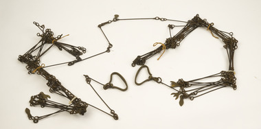
Gunter's Chain
... , and astronomer. survey Gunter's Chain ...This is a surveyor's chain or Gunter's chain, an instrument used for measuring length. It comprises 100 pieces of straight metal wire, looped together end to end, and fitted with swivel handles. Its overall length is one chain (22 yards or 66 feet). The Gunter's chain was named after its inventor, Edmund Gunter (1581-1626), an English clergyman, mathematician, and astronomer. survey -
Southern Sherbrooke Historical Society Inc.
Map, Dept of land s & Survey, Dandenong Ranges Area Sheet 28, Jan-56
Owned by David Walker, previously of Menzies Creek. Given by him to Rex Breen in 2001 for donation to society.Aerial survey map of parts of Gembrook, Monbulk and Naree Worran parishes (Victoria). Scale: 10 chains to 1 inch, contour interval 20 feet. Shows Menzies Creek and parts of Kallista, Clematis, Selby and Belgrave South. Ringwood D2C or 849D2C, Zone 7"16563" in pen on top left corner of reverse. -
![Survey metal tape on reel with leather bag. 10 yards in length, the metal chain is subdivided every 10 links [2.2 yards].](/media/collectors/4f729f7e97f83e03086018d1/items/5f87f8fd13cca91a6c1db65a/item-media/615a8287eb51660bb8dc9e31/item-fit-380x285.jpg) Queenscliffe Maritime Museum
Queenscliffe Maritime MuseumInstrument - Survey tape on metal reel in leather bag with other articles
A surveyors chain is actually a thin steel band on a reel and is used for accurate measurements. This 110 yard [101m] chain is subdivided every 10 links [2.2 yards or 2m]Items belonged to J P Larkin Government marine surveyor who worked on surveys up to 1938. He worked in Port Phillip and Queenscliff related surveys [e.g. Western channel, Queenscliff channel].Survey tape on metal reel in leather bag with other articles: plumb bobs, number pegs, drawing instruments in box and steel punchesMade by A.E. Parsons surveying instruments, 215 Queen Street Melbournesurveying equipment, j p larkin -
 Bendigo Historical Society Inc.
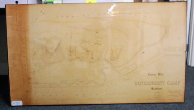
Map - CONTOUR PLAN OF THE GOVERNMENT CAMP SANDHURST 1854, 1994
Contour map (copy) of the Government Camp Sandhurst, 1854. Map is mounted on coreflute and laminated. Written in bottom righthand corner 'Contour Plan of the Government Camp, Sandhurst. Dec 1854. Signed by Richard Larritt, Assistant Surveyor, 11th December 1854.' Shown on map: Pall Mall, Bendigo Creek, Commissioner's Gully, View Place (now View Street), Post Office, Bank of Victoria, District Surgeon, Sandhurst Fire Brigade, Police Hospital, Flagstaff, Gold Office, License Shed, Military Barracks, Stables, Commissioner's Buildings, Police Office. Old Cemetery, Garden. Reference on righthand side: 'Stone or brick buildings are tinted in crimson. Wooden buildings tinted in Indian Ink. Tents and other temporary structures tinted in Burnt Sienna.' Scale of Chains, on bottom of map. Sticker on bottom left hand corner and back of map ' Presented by Survey and Mapping, Victoria, 7th Octber, 1994'.map, bendigo, government camp, pall mall, bendigo creek, commissioner's gully, view place (now view street), post office, bank of victoria, district surgeon, sandhurst fire brigade, police hospital, flagstaff, gold office, license shed, military barracks, stables, commissioner's buildings, police office. old cemetery, garden. , survey and mapping victoria. sandhurst, bendigo. -
 Kew Historical Society Inc
Plan, Survey Plan, Park Hill Road, Kew, 1880-1890
The streets identified on the survey plan - Cotham Road, Park Hill Road East, Park Hill Road West in Kew were each gazetted by the Victorian Government in 1865. The hand-coloured survey plan was completed by Holland Loxton, Town Clerk and Surveyor of the Borough of Kew from 1866. The unnamed survey plan includes names of land owners in addition to measurements (2 chains to 1 inch) and streets. Named owners include Webster, Payne and Francom which will enable us to narrow down the creation date of the survey.Handdrawn survey plan by a former surveyor and town clerk of KewHand drawn and coloured survey plan created by Holland Loxton, Surveyor and Town Clerk of Kew, showing land owned by Payne in Park Hill Road, Kew. The plan includes street names, land measurements and land owners.surveys - kew, maps - kew, holland loxton, park hill road - kew, holland loxton -- surveyor, survey plans -- parkhill road -- kew (vic.) -
Stawell Historical Society Inc
Memorabilia - Realia, 1900's
... One Chain Measure. Used for Survey or Farm Measure... grampians Stawell One Chain Measure. Used for Survey or Farm Measure ...One Chain Measure. Used for Survey or Farm Measurestawell -
 National Communication Museum
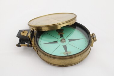
Equipment - Prismatic compass, Alfred E Sawtell, before 1872
After years of precursory surveying, debate and proposals the most ambitious civil engineering project of the day, the Overland Telegraph Line, began construction in September 1870. Superintendent of Telegraphs, Sir Charles Todd led the construction through “terra incognita,” guided by the precursory surveys of John McDowall Stuart and technologies such as his prismatic surveying compass. The unknown and hostile landscape claimed the lives of several men and scores of transport animals in the dogged pursuit of telegraphic connection to the rest of the world. Completed in August 1872, the Line connected Australia to the world via telegraph wires running 3,200 kilometres from Port Augusta in South Australia, to Darwin, then connecting via submarine cable to Java and beyond. The “earth [had been] girdled with a magic chain” according to the then Governor of New South Wales, Sir Hercules Robinson. How does it work? For use in surveying, the sight vane and prism are turned up on their hinge and the instrument is held horizontally either in the palm of one's hand or on a tripod. Two small discs of red and green glass attached to the prism can be flipped down over the sight line to reduce glare. The objective is to bring the subject into the sightline created by the prism, aligning with the thread of the sight-vane until the subject is bisected evenly. Once aligned, the division on the card may be read through the prism. This reading provides the magnetic azimuth, used for calculating the bearings of distant landmarks. Circular instrument mounted in a brass case with glass window and brass lid. The compass card face four black compass points printed on mint green paper; on the underside the magnetic needle would be affixed, all held in place by a brass knob at the centre. The arched labels of "Sawtell" and "Adelaide" and the Prince of Wales feathers appear to have been affixed with adhesive which has since yellowed in the areas of application on the compass card. The compass face is printed with numbers, every 10 degrees from 10 - 360, printed in reverse indicating this compass would have once held a mirror at the sighting bracket. On one side of the brass case is a brass hinged sighting-prism, possibly of ebonite. The sighting-prism is mounted in a hinged brass bracket on one edge of the brass case. It has two flip-type filter glasses (red and green) and folds down into a retracted travelling position. A hinged brass bracket on the opposite edge would have held the sighting bracket - carrying the sighting vane and mirror - which is now missing or removed. Under the hinge is a lever, possibly related to the movement of the bracket. Underneath the brass case is an indented circle with screw threads, possibly for attachment to a tripod, and indistinguishable marks scratched into the surface.Etched on to the centre of the lid, "Sawtell ADELAIDE / No 792." Affixed to the paper compass face, possibly from separate pieces of paper, "SAWTELL / ADELAIDE" with the Prince of Wales Feathers above "SAWTELL". Underneath on remains of white tape in red: "159."surveying, compass, charles todd, overland telegraph line, telegraph -
 City of Greater Bendigo - Civic Collection
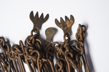
Instrument - Gunter Chain, not known
Gunter's chain (also known as Gunter’s measurement) is a distance measuring device used for surveying. It was designed and introduced in 1620 by English clergyman and mathematician Edmund Gunter (1581–1626). It enabled plots of land to be accurately surveyed and plotted, for legal and commercial purposes. The provenance of this particular Gunter Chain is unknown but it is believed to be used either by the City of Bendigo / Sandhurst or the Lands Department locally when measuring and laying out plots and streets locally. A 66-foot (20.1 m) chain divided into 100 links, marked off into groups of 10 by brass rings or tags. Each link is 7.92 inches (201 mm) long. A quarter chain, or 25 links, measures 16 feet 6 inches (5.03 m) also called a a rod (or pole) measure. Ten chains measure a furlong and 80 chains measure a statute mile. city of greater bendigo surveying -
 Mont De Lancey
Surveyors Chain, Circa 1890
... -and-dandenong-ranges Surveying equipment Surveyors chain with 100 metal ...Surveyors chain with 100 metal links.surveying equipment -
Federation University Historical Collection
Map - Map - Geological, Geological Survey of Victoria - Ballarat, 09/1858
Coloured Geological Map of Ballarat, edged with masking tape. The map show alluvial silt, gold drift, geological orders, volcanic, and gold workings. Scale is 8 chains to an inch. WGS 84 Centroid: 37 degrees 33 feet 33 inches south 143 degrees 52 feet 02 inches east W.E. extent: 5km NS extent: 3 kmballarat, ballaarat, geology, goldfield, phillips, j. phillips, mining, alfred selwyn, ferguson and mitchell -
Clunes Museum
Plan - TITLE PLAN, DEPT. OF LANDS AND SURVEY, PARISH OF CLUNES - COUNTY OF TALBOT, 1959
.1 1 PAGE PLAN LISTING TITLES FOR THE PARISH OF CLUNES 1959 (3 COPIES) SHEET 1 SCALE: 1 INCH TO 40 CHAINS .2 1 PAGE PLAN LISTING TITLES FOR THE PARISH OF CLUNES 1959 SHEET 2 SCALE: 1 INCH TO 2 CHAINSBY AUTHORITY A C BROOKS GOVT. PRINTER, MELBOURNE PARISH OF CLUNESparish of clunes, title plans clunes -
 Flagstaff Hill Maritime Museum and Village
Map - Survey Map, F.F. McGovern, Yangery - County of Villiers, 1884
... : 8 chains to 1 inch" Survey map of Yangery, titled "Yangery ...A surveyor was employed to measure the land designated as Yangery, County of Villiers, in the Borough of Warrnambool. The area on the map is similar to the earlier Farnham Survey undertaken by William Rutledge in the 1850's. Warrnambool was a Borough between 1863-1883. Coutours, waterways, sea and other significant points are shown. The distances are accurately measured. This survey map was used for planning future land sales, recreation areas and roads. WILLIAM RUTLEDGE (1806-1876) William Rutledge surveyed the land known as Farnham in southwest Victoria in 1843. His tenants made him a profitable business from working the land there. In 1863 Rutledge moved from nearby Port Fairy to Farnham and became very successful in breeding sheep, which he imported from J.R. Kirkham of Lincolnshire, England. He also bred horses on his land. The survey map of Yangery is important for its connection with renowned surveyor William Rutledge. The map shows the growth of landholders in the district when compared to the original Rutledge survey of the 1850's.Survey map of Yangery, titled "Yangery - County of Villiers". Printed on white paper, mounted on brown paper. c. 1863-1876. Comments printed on the Map include; Special Survey by William Rutledge, Photo-lithographed at the Department of Lands and Survey, Melbourne by W.J. Burson, Price 1/- [one shilling]. Scale is in Chains. Map has boundaries of Koroit Borough, Meerai, Purnim, Wangoom, Borough of Warrnambool, Mentions the Proposal of Tower HIll for Public Recreation. The map names the owners of the land at that time. Hand written pencil marks and figures and "Sauls fence" drawn on map. Hand written pencil markes and figures and "Sauls fence" drawn onto map. "For Department Use only". "Scale: 8 chains to 1 inch" flagstaff hill, warrnambool, shipwrecked-coast, flagstaff-hill, flagstaff-hill-maritime-museum, maritime-museum, shipwreck-coast, flagstaff-hill-maritime-village, county of villiers map, yangery district, w.j. burson, borough of warrnambool, koroit, purnim, meerai, wangoom, proposal of tower hill for public recreation, special survey by william rutledge, william rutledge, farnham, lincolnshire sheep, clydesdale -
 Bendigo Military Museum
Photograph - Royal Australian Survey Corps Surveyors in the Field – Project Cutlass, New Guinea, 1956 – 1957
This is a set of 23 photographs of surveyors and support staff in the field undertaking tasks in New Guinea 1956 – 1957. The surveyors were employed in the establishment of mapping and geodetic control for Project Cutlass, the “Ship-Shore” survey of the New Ireland province. In this survey operation surveyors used theodolites to observe horizontal and vertical angles and chains to measure base line distances between survey stations. Bob Skitch shown in photo .7P was in the 2nd year of his career in the Australian Army. He achieved the rank of Lieutenant-Colonel, and his last appointment was the CO of the Army Survey Regiment from 1976 to 1980.This is a set of 23 photographs of surveyors and support staff in the field undertaking duties during Project Cutlass located in New Ireland, New Guinea 1956 – 1957. The photographs were printed on photographic paper and are part of the Army Survey Regiment’s Collection. The photographs were scanned at 300 dpi. .1) - Photo, colour, 1956. Surveyors travelling main road from Kavieng to Namatanai, New Ireland. .2) - Photo, colour, 1956. Unidentified surveyors assessing recovery of their vehicle after bridge collapsed on west side of New Ireland. .3) - Photo, colour, 1956. Unidentified surveyors assessing recovery of their vehicle after bridge collapsed over flooded creek on west side of New Ireland. .4) - Photo, colour, 1956. Survey personnel L to R: Bev Uwins, John Lambie, Bob Thompson, New Ireland. .5) - Photo, colour, 1956. Survey base camp, New Ireland. .6) - Photo, black & white, 1956-1957. Geoff Helsham with possible human remains, New Ireland. .7) - Photo, black & white, 1956-1957. Bob Skitch undertaking survey observations using Wild T2 theodolite, New Ireland. .8) - Photo, black & white, 1956-1957. Chas Beach undertaking survey observations using Wild T2 theodolite, New Ireland. .9) & .10) - Photo, black & white, 1956-1957. Kev Parker (cook) New Ireland. .11) - Photo, colour, 1957. Brian Berkery taking a break, Top Manor Island, Lihir Island Group off New Ireland. Latitude -2° 46”, Longitude 152° 40”. .12) - Photo, colour, 1957. Survey base camp L to R: Chas Beach, Bev Uwins, Feni Islands, New Ireland. Latitude -4° 05”, Longitude 153° 45”. .13) - Photo, colour, 1957. A Hous Kiap. (Kiaps, known formally as district officers and patrol officers, were travelling representatives of the British and Australian governments), New Ireland. .14) & .15) - Photo, colour, 1957. L to R: Joe Farrington, Tom Royle Bob undertaking survey observations using theodolites from an improvised timber tower, New Ireland. .16) & .17) - Photo, colour, 1957. US Army ship FS216 used for ship-to-shore triangulation docked at Rabaul, New Britain. .18) - Photo, colour, 1957. US Army ship FS216 used for ship-to-shore triangulation docked at Kavieng, New Ireland. Sight target on top of mast. .19) - Photo, colour, 1957. Survey personnel onboard US Army ship FS392, L to R: Peter Frodsham, Bob Thompson, Doc Reid, John Underwood, remainder unidentified, New Ireland. .20) - Photo, colour, 1957. Survey base line party heading ashore, New Ireland. .21) - Photo, colour, 1957. Survey personnel rowing US Army assault boat L to R: Kev Parker, Chas Beach, folded up survey beacons overhanging stern, New Ireland. .22) - Photo, colour, 1957. Les Bailey onboard US Army ship departing Rabaul, New Britain for Brisbane. .23) - Photo, colour, 1957. Ron Newman onboard US Army ship departing Rabaul, New Britain for Brisbane. Active volcano in background..1P to .23P annotated on back – ‘Operation Cutlass’, personnel names, the year and the location. royal australian survey corps, rasvy, army survey regiment, fortuna, a, army svy regt, asr, surveying -
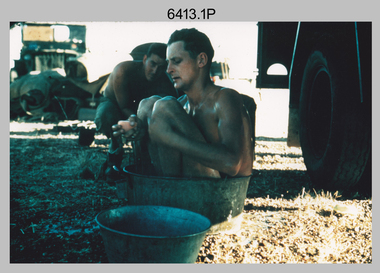 Bendigo Military Museum
Photograph - Royal Australian Survey Corps Surveyors in the Field – North Queensland, 1958
This is a set of seven photographs of surveyors and support staff in the field undertaking duties in North Queensland in 1958. The surveyors were employed in the establishment of mapping and geodetic control. In this era surveyors used theodolites to observe horizontal and vertical angles and chains to measure base line distances between survey stations. Bob Skitch shown in photos .4P to .6P was in the 2nd year of his career in the Australian Army. He achieved the rank of Lieutenant Colonel and his last appointment was the CO of the Army Survey Regiment from 1976 to 1980. The annotation on the back of photo .5P ‘Black foreground is where Bob Skitch boiled billy and started a grass fire’.This is a set of seven photographs of surveyors and support staff in the field undertaking duties in North Queensland in 1958. The photographs were printed on photographic paper and are part of the Army Survey Regiment’s Collection. The photographs were scanned at 300 dpi. .1) - Photo, colour, 1958. Surveyor in Nth QLD enjoying a bath. L to R: Don Cocker, Bob Thompson. .2) - Photo, colour, 1958. Don Cocker surveyor in Nth QLD, enjoying a bath. .3) - Photo, colour, 1958. Surveyors Nth QLD undertaking survey observations, using MRA1 tellurometer to measure base-line distances. L to R: Len Davies, Lou Sommer, John Van De Graff. MRA1 was covered to stop overheating. .4) - Photo, colour, 1958. Surveyors south of Richmond, QLD digging holes for the erection of a Bilby observation tower. L to R: John Van De Graff, Bob Skitch, Kev Moody, Mal Hayes, Don Gray .5) - Photo, colour, 1958. Surveyors south of Richmond, QLD erecting a Bilby observation tower. L to R: Tom Royle, Bob Skitch (on ground level), Mal Hayes. .6) - Photo, colour, 1958. Surveyors south of Richmond, QLD erecting a Bilby observation tower. L to R: Tom Royle, Bob Skitch, Mal Hayes, Jim McGill (on ground level). .7) - Photo, colour, 1958. Surveyors south of Richmond, QLD undertaking survey measurements from a Bilby observation tower..1P to .7P annotated on back – personnel names, the year and the location. Annotated on back of .5P ‘Black foreground is where Bob Skitch boiled billy and started a grass fire’.royal australian survey corps, rasvy, army survey regiment, asr, army svy regt, fortuna, surveying -
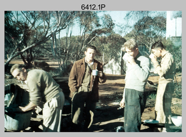 Bendigo Military Museum
Photograph - Royal Australian Survey Corps Surveyors in the Field – Victoria, 1956 - 1958
This is a set of two photographs of surveyors and support staff in the field undertaking tasks in Victoria 1956 – 1958. The surveyors were employed in the establishment of mapping and geodetic control. In this era surveyors used theodolites to observe horizontal and vertical angles and chains to measure base line distances between survey stations. This is a set of 23 photographs of surveyors and support staff in the field undertaking duties in Victoria 1956 – 1958. The photographs were printed on photographic paper and are part of the Army Survey Regiment’s Collection. The photographs were scanned at 300 dpi. .1) - Photo, colour, 1956. Surveyors enjoying a tea break. L to R: Tom Gilbert (cook), Barry Broad, Tony Slattery, John Van De Graff. Taken at Boonoonar, a locality south of Mildura. .2) - Photo, colour, 1958. Surveyors taking a break from driving. L to R: Leo Bub, Bob Thompson. Taken at Puckapunyal..1P to .2P annotated on back – personnel names, the year and the location. royal australian survey corps, rasvy, army survey regiment, asr, army svy regt, fortuna, surveying -
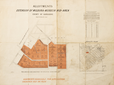 Merbein District Historical Society
Map - Allotments Extension of Mildura-Merbein Mid-Area, Allotments available, 23 November 1920
Allotments available to Discharged Soldiers Discharged Soldier's Settlement Act Historic Large map, folded in 4, coloured map of Merbein indicating allotments available and locality plan. Scale 10 chain to 1 inchPhoto-Lithographed at Department of lands Survey, Melbourne J. Butson 23.11.20discharged soldiers, ww1, soldier settlement, irrigation -
 Forests Commission Retired Personnel Association (FCRPA)
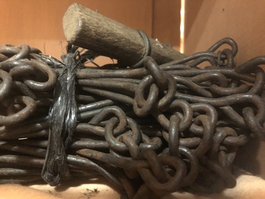
Gunter's Chain
Before metrication was introduced into Australia in the 1970s land was measured in chains and links. Many old parish plans show length measurements in chains and links. Area was shown in acres, roods and perches. Gunter's chain was used for measuring distance in surveying. It was designed and introduced in 1620 by English clergyman and mathematician Edmund Gunter (1581–1626). Gunter developed the measuring chain of 100 links. The chain and the link, became statutory measures in England and subsequently the British Empire. After metrication units of length were measured in meters and area in hectares. The chain was later superseded by steel ribbon tape.The 66 foot long brass Gunter's Chain is divided into 100 links (each 7.92 inches long), and marked off into groups of 10 by shaped tags which simplify intermediate measurement. It was heavy but flexible enough to be dragged through the bush on surveying transects.(Hence the common forestry term "chainman). The chain was a precision part of a surveyor's equipment. It required frequent calibration, yet needed to be sturdy enough to be dragged through rough terrain for years. It has brass hand grips at each end of chain. 1 chain = 100 links = 22 yards = 66 feet = 792 inches. 10 chains = furlong 80 chains = 1 mile 1 acre = 10 square chains = 4 roods (1/4 acre) = 40 perches.forest measurement, surveying, forests commission victoria (fcv) -
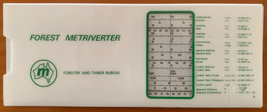 Forests Commission Retired Personnel Association (FCRPA)
Forest Metriverter, Side Rule
Decimal currency was spectacularly introduced in an overnight overthrow on 14 February 1966, but it took another 8 years before metrication finally arrived in the forest and timber industry. Eventually, the measurement of logs and sawn timber changed from imperial, and excruciating, measures such as super feet of sawn timber, billets and cunits (100 cubic feet) of stacked pulpwood and hoppus log volumes to simpler cubic metres. Measuring firewood was a particular nightmare. For example, there were standard chords, stove cords, kitchen cords, running cords, face cords, thrown chords, fencing cords, country cords, long cords, raummeter or steres (1m x 1m x 1m). A standard cord of firewood had a volume of 128 cubic feet, measured as a pile 8 feet long, 4 feet high and 4 feet wide (3.624 m3). And how about this for confusing…. in Victoria, an imperial or long ton (by measure) of green firewood was a stack 5 feet long billets (2 axelengths at 2′ 6″ each), one axelength high (2′ 6″) and two axelengths long (5 feet) equalling 62.5 cubic feet. For added befuddlement, there were three different sorts of tons: Imperial tons or long tons, American short tons and metric tonnes (spelled with two n’s). Not forgetting that a cubic imperial ton of firewood (40 cubic feet) which equalled 1.133 cubic metre. The metrication process began in 1974 and was completed by 1976 but the transition was not without its challenges along the supply chain for foresters, overseers, logging contractors, sawmillers, hardware stores and builders alike. Timber lengths changed from feet to metres but were still sold in multiples of one foot or 0.3 m (1.8, 2.1, 2.4, 2.7 etc) whereas a menacing lump of 4-Bee-2 transformed into a rather less colourful 100mm by 50mm. Measurement and calculations of area also became so much easier in hectares rather than complicated acres, roods and perches. The Forest Metriverter slide-rule was issued by the Forestry and Timber Bureau to make metric conversions easier.Forest MetriverterRoss Pennyforest measurement, surveying, forests commission victoria (fcv) -
 Bacchus Marsh & District Historical Society
Map, Limestone Reserve Parish of Merrimu 1888
Limestone deposits in the Coimadai area 10 kilometers north of Ballarat were first worked in the 1850s. The area was quarried for limestone for many years by various people and companies. The surveyor's name who produced this plan is inscribed on the map and below this is the name P. L. Alkemade, who presumably paid for the map to be produced. In 1886 Petrus Alkemade in partnership with Matthew Egan established the Alkemade Hydraulic Lime and Cement Company. The Alkemade family were involved in the limestone industry over several generations at Coimadai.Single page map showing part of the Limestone reserve near Coimadai in the Parish of Merrimu. Scale 4 chains to 1 inch. Part of a set of maps which are pasted into a bound volume containing 76 maps or plans in total. High resolution digital image stored on BMDHS computer network. Copy of plan surveyed by Mr. G? [illegible] an authorised surveyor on 17th July 1888. P. L. Alkemadebacchus marsh victoria maps, lime kilns coimadai, limestone, coimadai victoria maps, alkemade family coimadai