Showing 122 items
matching victorian bushfires
-
 Orbost & District Historical Society
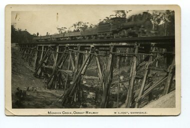
black and white photograph, Vogt. W.S, first half 20th century
This 97km Bairnsdale to Orbost extension through rugged terrain was reputed to have been the most difficult rail project undertaken in Victoria. This wooden bridge was one of the unique railway bridges of the East Gippsland Railway line. Mundic Creek Bridge is of unique design because the line crosses at a very sharp angle. This bridge like many others on the line have "disappeared". This one, probably because of a bushfire.The Bairnsdale to Orbost rail line contains the most varied range Of timber & timber composite bridges on any Victorian line. This photograph is a record of that. A black / white photograph of a train on a wooden railway bridge at Mundic Creek.on front - Mundic Creek, Orbost Railway W.S.Vogt, Bairnsdalemundic-creek-bridge east-gippsland-railway -
 Orbost & District Historical Society
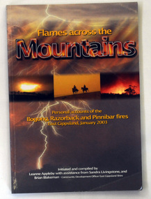
book, Flames Across The Mountains, 2004
... bushfires reminiscences Victorian-high-country... during the 2003 bushfires in the Victoria High Plains. bushfires ...This book was initiated and compiled by Leanne Appleby with assistance from Sandra Livingstone and Brian Blakeman. After hearing some of the stories of the events that took place during these fires, Leanne Appleby decided that collating and recording the stories in book form would "perhaps relieve some of the tension and stress". Brian Blakeman as Community Development Officer, East Gippsland Shire, and Sandra Livingstone of Buchan became involved in the project.This is a historic record of events that took place during the 2003 bushfires in the Victoria High Plains.A 206 pp paperback book titled Flames across the Mountains. the front cover is representative of fire and lightning. In the centre is a background of bushfire and the silhouette of two mounted bushmen. The book contains personal accounts of the Bogong, Razorback and Pinnibar fires in East Gippsland, January 2003. It has both b/w and coloured photographs.bushfires reminiscences victorian-high-country -
 Orbost & District Historical Society
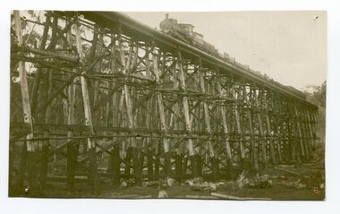
black and white photograph, 1977?
In 1977 great efforts were being made to preserve this bridge, the highest trestle bridge in Victoria at Stoney Creek. The Stony Creek Trestle Bridge was built in 1916 when the existing rail line from Melbourne to Bairnsdale was extended to Orbost. This 97km Bairnsdale to Orbost extension through rugged terrain was reputed to have been the most difficult rail project undertaken in Victoria. In service for over 60 years the bridge was damaged by bushfire in 1980, with the last train crossing in 1987. At 247m long and 20m high, it is the largest standing bridge of its kind in the State, and is listed on the Register of Historic Sites. Built of red ironbark and grey box timber, it is a fine example of the early engineering skills that utilised the resources and materials found on site.The Bairnsdale to Orbost rail line contains the most varied range of timber & timber composite bridges on any Victorian line. The Stoney Creek bridge is listed on the Victorian Heritage Register for its architectural and historical significance.A black / white photograph of a very large trestle bridge. a steam locomotive, with loaded goods trucks, is on the bridge. stoney-creek trestle-bridge railway east-gippsland-railway -
 Kiewa Valley Historical Society
Roper's Hut Memorabilia
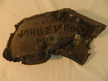
Roper's Hut was built in 1939 and was burnt down in 2003. It was rebuilt in 2008 and is situated on the Bogong High Plains on Duane Spur (where Duane's hut had been before it too was destroyed by (1939) bushfires, between Mt Nelse and Big River. The original hut was used as a shelter for cattlemen who grazed their cattle on the High Plains during summer. The Victorian High Country Huts Association Inc. members and friends helped rebuild the hut which is now used as an emergency shelter for visitors to the High Plains.The memorabilia is significant as the items belonged to the Roper family who were one of the original settlers of the Kiewa Valley and one of the original families who drove their cattle up to the Bogong High Plains. The burnt plaque and forks and the rebuilding of the huts (Duane's & Roper's) are significant as bush fires are a constant threat to the Bogong High Plains destroying large areas at a time.1. Bronze Plaque and 2 damaged forks from Roper's Hut which was destroyed by bush fires in 2003. 2. DVD & USB and hard copy photos of the rebuild of Roper's Hut in January 2008.The plaque had 'In Memory of / John F. P. Roper/ died 3-12-1977 / Aged 78 years / He built the original hut Feb. 1939'roper's hut, cattlemen, bogong high plains, bronze plaque, roper family, bush fires -
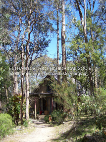 Eltham District Historical Society Inc
Photograph - Digital Photograph, Marguerite Marshall, Neil Douglas house, Bend Of Islands, 3 October 2006
Mud brick house first owned by naturalist and artist Neil Douglas and Helen (Abbie) Heathcote at the Bend of Islands. They were original residents in the 1970s. This house is on the Victorian Heritage Database and is considered locally significant. Covered under Heritage Overlay, Nillumbik Planning Scheme Published: Nillumbik Now and Then / Marguerite Marshall 2008; photographs Alan King with Marguerite Marshall.; CoverThis collection of almost 130 photos about places and people within the Shire of Nillumbik, an urban and rural municipality in Melbourne's north, contributes to an understanding of the history of the Shire. Published in 2008 immediately prior to the Black Saturday bushfires of February 7, 2009, it documents sites that were impacted, and in some cases destroyed by the fires. It includes photographs taken especially for the publication, creating a unique time capsule representing the Shire in the early 21st century. It remains the most recent comprehenesive publication devoted to the Shire's history connecting local residents to the past. nillumbik now and then (marshall-king) collection, bend of islands, neil douglas house, neil douglas -
 Eltham District Historical Society Inc
Photograph - Digital Photograph, Alan King, St Margaret's Anglican Church, Pitt Street, Eltham, 30 January 2008
St Margaret’s Church of England was officially opened on December 12, 1861. It is the oldest intact church building in Eltham. At the time it was known as Christ Church until its consecration in 1871, when it was completely free of debt (£1,700 for the church and parsonage) despite the district’s poverty. This was largely due to the free labour and materials, including locally made bricks donated by local artisans and others. The church is historically significant because it is the oldest church in the former Shire of Eltham and has associations with the philanthropist and founder of Brighton, Henry Dendy (who donated the land on which the church is built), the architect Nathaniel Billing and the prominent local builder, George Stebbing. The church is architecturally and aesthetically significant because it is constructed in the Gothic Revival style with several stained-glass windows of various dates and is also a very early use of polychromatic brickwork in Victoria. Billing was one of the first Melbourne architects to employ polychromatic brickwork and an important early architect. The rear wall was intended to be temporary. A major feature of the design is the large buttresses with long, steeply graded upper faces. The overall design is well proportioned with the surface brick patterns relieving an otherwise austere design. The church is spiritually and socially significant because it has been an important place of worship for the people of Eltham for almost 150 years. The land on which the buildings stand was donated by Henry Dendy. Dendy arrived in Melbourne in 1841 after purchasing in England eight square miles at Brighton under the system of "special surveys". After this land passed out of his hands, Dendy moved about Victoria, visited England, then returned to settle in Eltham where he purchased a flour mill. Dendy chaired the meeting held in 1860 “for the purpose of devising such means as may be expedient for the establishment of a Church of England in the township of Eltham”. He became chairman and treasurer of the church committee. Unlike the establishment of many early churches in Victoria where a vicar was appointed to a parish and later a permanent church was constructed, the population at Eltham initiated action to build a church. The nearest church at that time was at Heidelberg and the Eltham settlement was part of the parish of St Johns Heidelberg. Isolation and the tedious, time consuming journey between Heidelberg and Eltham resulted in the Eltham community taking its own action. The original vicarage (Dendy House) at the rear of the church is also an important part of the cultural significance of this place because it is connected to the church and the development of the Eltham area. Together, the church and the vicarage are aesthetically significant because they form a significant streetscape feature. The mud-brick community hall designed by Robert Marshall was added in 1978. In 2014 the original temporary rear wall was removed as part of a modern extension designed by Architects Atelier Wagner and constructed by Conrad Construction and Management. Covered under Heritage Overlay, Nillumbik Planning Scheme. National Trust of Australia (Victoria) State significance Victorian Heritage Published: Nillumbik Now and Then / Marguerite Marshall 2008; photographs Alan King with Marguerite Marshall.; p67This collection of almost 130 photos about places and people within the Shire of Nillumbik, an urban and rural municipality in Melbourne's north, contributes to an understanding of the history of the Shire. Published in 2008 immediately prior to the Black Saturday bushfires of February 7, 2009, it documents sites that were impacted, and in some cases destroyed by the fires. It includes photographs taken especially for the publication, creating a unique time capsule representing the Shire in the early 21st century. It remains the most recent comprehenesive publication devoted to the Shire's history connecting local residents to the past. nillumbik now and then (marshall-king) collection, eltham, st margaret's anglican church, st margaret's church, christ church -
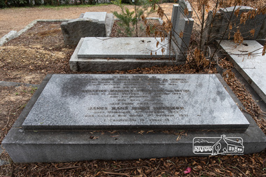 Eltham District Historical Society Inc
Photograph, Peter Pidgeon, Grave of James Hans Morrison and Beatrice Wanliis Morrison, Eltham Cemetery, Victoria, 5 April 2021
Beatrice Irvine was the daughter of former Victorian Premier Sir William Irvine. From age 13 she lived at ‘Killeavey’ off Laughing Waters Road (later accessed from Reynolds Road). In 1923 she married James Morrison and the couple received Killeavey as a wedding gift. The property supported fruit and vegetable growing as well as an impressive botanical garden. But James died in 1936 after a period of ill health, leaving Beatrice to support their six children. To make matters worse, the house was totally destroyed in the Black Friday bushfires in 1939 but was rebuilt. Beatrice became involved in community issues. In particular, she was an active member of the Eltham Women's Auxiliary, which was formed in 1945 to raise funds for the establishment of an Eltham War Memorial. From the outset, it was decided that this would take the form of a Baby Health Centre, a Pre-School and a Children’s Library, set in a garden of remembrance. Thanks to tireless fund-raising, the project came to fruition in the 1950s when, one by one, the three children's welfare buildings opened in Main Road (having previously been in temporary premises): they are collectively known as the Eltham War Memorial site. Beatrice continued to live at Killeavey and became well regarded as a botanist and naturalist. She died in 1989 and is buried in Eltham Cemetery with her husband and one of their sons. The (rebuilt) house has since been demolished. All that remains is a fragment of the garden. In Fond Memory Of James Hans Morrison Croix de Guerre Born St Peters Pass Oatlands Tasmania 6th June 1880 Died Killeavey Eltham 16th November 1936 And his beloved wife Beatrice Wanliss Morrison (nee) Irvine Born St Kilda Victoria 22nd January 1899 Died 5th November 1989 Who rest here James Hans Irvine Morrison Born Melbourne 11th October 1927 Died Gorora New Guinea 1st October 1971Born Digitaleltham cemetery, gravestones, beatrice wanliss morrison (nee irvine), james hans irvine morrison, james hans morrison, croix de guerre (france) -
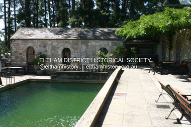 Eltham District Historical Society Inc
Photograph - Digital Photograph, Alan King, Swimming Pool, Montsalvat, 8 January 2008
Re-claimed material were used during the construction of Montsalvat, the artists colony in Eltham. The swimming pool was donated and cubicles were built for the students with their initials marked in tiles on each doorstep. Covered under National Estate, National Trust of Australia (Victoria) State Significance, Victorian Heritage and Heritage Overlay, Nillumbik Planning Scheme. Published: Nillumbik Now and Then / Marguerite Marshall 2008; photographs Alan King with Marguerite Marshall.; p131This collection of almost 130 photos about places and people within the Shire of Nillumbik, an urban and rural municipality in Melbourne's north, contributes to an understanding of the history of the Shire. Published in 2008 immediately prior to the Black Saturday bushfires of February 7, 2009, it documents sites that were impacted, and in some cases destroyed by the fires. It includes photographs taken especially for the publication, creating a unique time capsule representing the Shire in the early 21st century. It remains the most recent comprehenesive publication devoted to the Shire's history connecting local residents to the past. nillumbik now and then (marshall-king) collection, eltham, montsalvat, swimming pool -
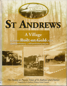 Eltham District Historical Society Inc
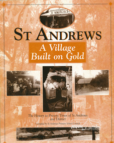
Book, St Andrews Primary School Council, St Andrews: A Village Built on Gold : the history to present day of St Andrews and District compiled by St Andrews Primary School Council, 2008
This history of the Victorian town of St. Andrews (formerly Queenstown) and its surroundings was written to celebrate the 140th anniversary of St Andrews Primary School. Describes the displacement of the Aboriginal inhabitants of the area, European settlement and the Gold Rushes and the Caledonia diggings. Discusses establishment of the school, church and cemetery and various other notable events. The school in 1998 and speculations on the future by primary school pupils. Contents: Introduction The First People Mining- What a rush! The School The Church Queenstown Cemetery The Hotels The Police Paddocks The Families Queenstown in the early twentieth century The Queenstown Bush Fire Brigade The 1st Queenstown Scout troop Queenstown, the 1940s and 1950s The Characters Odds and Sods St Andrews - The Present Times The Future St Andres Primary School in 1998This book is significant in that it documents the history of the St Andrews community from the indigenous presence through its foundation during the Victorian Gold Rush through to local bushfires and predictions of the future by local primary schools students in 1998. It remains the only significant secondary source publication written specifically on this rural community.Reprint edition with index 158 p. : ill., ports ; indexEx Eltham College copy Bendigo bank donation label inside cover Title page with stampings for D.D. Davey Senior Library Rear page date due slip st andrews, queenstown -
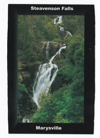 Marysville & District Historical Society
Postcard (item) - Colour postcard, Donovan Wilson, Steavenson Falls-Marysville, Pre 2009
A colour photograph of Steavenson Falls in Marysville in Victoria.A colour photograph of Steavenson Falls in Marysville in Victoria.The Steavenson Falls is named after the Victorian Assistant Commissioner of Roads and Bridges, John Steavenson who arrived in Victoria in the early 1860s. This postcard was posted on January 15, 2009, just 3 weeks before Marysville was destroyed in the Black Saturday bushfires. This postcard was produced by Donovan Wilson as a souvenir of Marysville.Steavenson Falls are one of the tallest in/ Victoria, with 5 cascades, a total decent/ of 122 meters, the last having a clear/ drop of more than 21 meters. Donovan Wilson/ Mystic Mountain Photography JAN/ 15/ 2009/ 6 PM Couldn't see a blooming thing beause/ of all the trees. They totally obscure/ the view. Something must be done./ Settled in. Will go to see falls/ when lit up (the Falls, not us)/ Love from us both./ Marysville is a charming/ little place - thanks for/ introducing us./ Love/ Wendy & Douglas Ms Marie Chaltorton/ 4 St Catherine's Court/ MORNINGTON/ VIC/ 3931 steavenson falls, marysville, victoria, waterfalls, donovan wilson, postcard, souvenir, john steavenson -
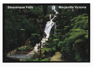 Marysville & District Historical Society
Postcard (item) - Colour postcard, Donovan Wilson, Steavenson Falls-Marysville Victoria, Post 2009
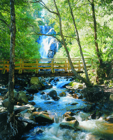
A colour photograph of Steavenson Falls in Marysville in Victoria. A colour photograph of Steavenson Falls in Marysville in Victoria. The Steavenson Falls is named after the Victorian Assistant Commissioner of Roads and Bridges, John Steavenson who arrived in Victoria in the early 1860s. The photograph shows the footbridge over the falls that was built after the Black Saturday bushfires which destroyed Marysville and the surrounding area. This postcard was produced by Donovan Wilson as a souvenir of Marysville.Steavenson Falls are one of the tallest in/ Victoria, with 5 cascades, a total decent/ of 122 meters, the last having a clear/ drop of more than 21 meters. Place/ Stamp/ Here Donovan Wilsonsteavenson falls, marysville, victoria, waterfalls, donovan wilson, postcard, souvenir, john steavenson -
 Marysville & District Historical Society
Photograph (item) - Colour photograph, Pre 2009
A colour photograph of Steavenson Falls in Marysville in Victoria.A colour photograph of Steavenson Falls in Marysville in Victoria. The photograph shows the viewing platform that was destroyed in the 2009 Black Saturday bushfires. The Steavenson Falls is named after the Victorian Assistant Commissioner of Roads and Bridges, John Steavenson who arrived in Victoria in the early 1860s.steavenson falls, waterfalls, marysville, victoria, john steavenson, 2009 black saturday bushfires -
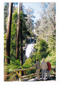 Marysville & District Historical Society
Photograph (item) - Colour photograph, September 2008
A colour photograph of three men standing at the viewing platform looking at Steavenson Falls in Marysville in Victoria.A colour photograph of three men standing at the viewing platform looking at Steavenson Falls in Marysville in Victoria. This infrastructure was destroyed in the 2009 Black Saturday bushfires. The Steavenson Falls is named after the Victorian Assistant Commissioner of Roads and Bridges, John Steavenson who arrived in Victoria in the early 1860s.September 2008steavenson falls, waterfalls, marysville, victoria, john steavenson, 2009 black saturday bushfires -
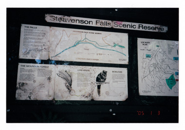 Marysville & District Historical Society
Photograph (item) - Colour photograph, 03-01-2005
Shows the sign at the Steavenson Falls Scenic Reserve.Shows the sign at the Steavenson Falls Scenic Reserve. This sign was destroyed in the 2009 Black Saturday bushfires. The Steavenson Falls is named after the Victorian Assistant Commissioner of Roads and Bridges, John Steavenson who arrived in Victoria in the early 1860s.'05 1 3 3.01.05. Marysville (from Helga Walsh)steavenson falls, steavenson falls scenic reserve, mountain forest, lyrebird, bobuck, mountain brushtail possum, marysville, victoria, john steavenson, 2009 black saturday bushfires -
 Marysville & District Historical Society
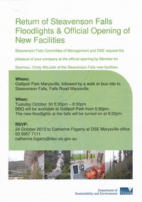
Flyer (item) - Invitation, Department of Sustainability and Environment, Return of Steavenson Falls Floodlights & Official Opening of New Facilities, 2018
A flyer inviting guests to an event at Steavenson Falls in Marysville in Victoria run by the Victorian Department of Sustainability and Environment.A flyer inviting guests to an event at Steavenson Falls in Marysville in Victoria run by the Victorian Department of Sustainability and Environment. This event was held to commemorate the return of the Steavenson Falls floodlights and the official opening of the new facilities after the old facilities were destroyed in the 2009 Black Saturday bushfires. The Steavenson Falls were named after the Victorian Assistant Commissioner of Roads and Bridges, John Steavenson who arrived in Victoria in the early 1860s.steavenson falls, waterfalls, marysville, victoria, department of sustainability and environment, floodlighting, john steavenson -
 Marysville & District Historical Society
Photograph (item) - Black and white photograph, Unknown
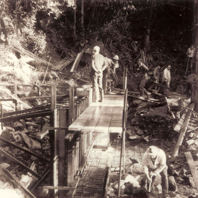
A black and white photograph which shows a group of men constructing the form work for the dam at the base of Steavenson Falls.A black and white photograph shows a group of men constructing the form work for the dam at the base of Steavenson Falls. Steavenson Falls provides Marysville with the town's drinking water which is considered to be the second-best drinking water in the world. The Steavenson Falls are named after the Victorian Assistant Commissioner of Roads and Bridges, John Steavenson who arrived in Victoria in the early 1860s.steavenson falls, marysville, victoria, waterfalls, john steavenson, 2009 black saturday bushfires -
 Marysville & District Historical Society
Photograph (item) - Black and white photograph, Unknown
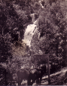
A black and white photograph which shows two saddled horses standing at the sign that once stood near the track that lead to the base of Steavenson Falls in Marysville in Victoria.A black and white photograph which shows two saddled horses standing at the sign that once stood near the track that lead to the base of Steavenson Falls in Marysville in Victoria. The sign was destroyed in the 2009 Black Saturday bushfires. The Steavenson Falls is named after the Victorian Assistant Commissioner of Roads and Bridges, John Steavenson who arrived in Victoria in the early 1860s.STEAVENSON FALLS/ MARYSVILLE/ HEIGHT 271 FEETsteavenson falls, marysville, victoria, waterfalls, john steavenson -
 Marysville & District Historical Society
Photograph (item) - Colour photograph, Pre 2009
A colour photograph of the wooden bridge over the Steavenson River at the base of the Steavenson Falls in Marysville in Victoria.A colour photograph of the wooden bridge over the Steavenson River at the base of the Steavenson Falls in Marysville in Victoria. This bridge was destroyed in the 2009 Black Saturday bushfires. The Steavenson Falls are named after the Victorian Assistant Commissioner of Roads and Bridges, John Steavenson who arrived in Victoria in the early 1860s.steavenson river, steavenson falls, marysville, victoria, waterfalls, john steavenson, 2009 black saturday bushfires -
 Marysville & District Historical Society
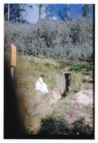
Photograph (item) - Colour photograph, 04-1960
A colour photograph of the entrance to a fire dugout on Mount Margaret near Marysville in Victoria.A colour photograph of the entrance to a fire dugout on Mount Margaret near Marysville in Victoria. The fire refuge dugout, which developed in the era of bush sawmilling in the early twentieth century, was a distinctive cultural response to the history of fire in the tall Victorian forests. Few dugouts were built in other forest regions of Australia, but those that did exist in these Victorian ranges saved dozens of lives in the fires of Black Friday 1939.27 'Fire Dug out' Mt Margaret April 1960mount margaret, marysville, victoria, fire dugout, sawmilling industry, black friday 1939, bushfire -
 Marysville & District Historical Society
Document (Item) - Information document, Victorian Bushfire Reconstruction and Recovery Authority, Marysville Heart Project, 2010
... Victorian Bushfire Reconstruction and Recovery Authority... in Victoria. marysville victoria 2009 black saturday bushfires ...A document outlining the re-building and re-development of Marysville in Victoria.A document outlining the re-building and re-development of Marysville in Victoria.marysville, victoria, 2009 black saturday bushfires, marysville and triangle urban design framework, gallipoli park, murchison street, marysville community centre -
Marysville & District Historical Society
Document (Item) - Information document, Victorian Bushfire Reconstruction and Recovery Authority, Marysville - Murchison Street and Town Amenity Project, 2010
... Victorian Bushfire Reconstruction and Recovery Authority... Amenity Project Document Information document Victorian Bushfire ...A document outlining the re-building and re-development of Murchison Street in Marysville in Victoria.A document outlining the re-building and re-development of Murchison Street in Marysville in Victoria.marysville, victoria, 2009 black saturday bushfires, murchison street -
Federation University Historical Collection
Book, Royal Commission into National Natural Disaster Arrangements, 2020
Two volume report into National Natural Disaster Arrangements, including a volume of attachments. This report is also known as the Bushfires Royal Commision. non-fictionroyal commission, natural disaster, bushfire, mark binskin, natural hazards, australian defence force, aerial, aircraft, evacuation planning, emergency information, abc, air quality, health, wildlife, heritage, indigenous land management, bushfire hazard reduction, fuel management, volunteers, disaster recovery, blue shield, dja dja wurrung clans aboriginal corporation, victorian farmers federation, black summer -
 Marysville & District Historical Society
Photograph (Item) - Colour photograph, Unknown
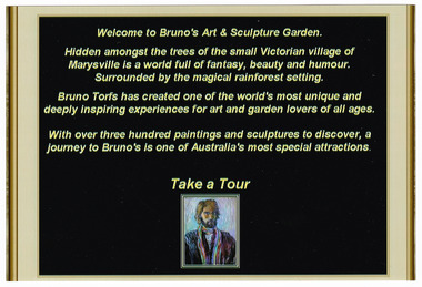
A colour photograph taken of a sign at then entrance to Bruno's Art & Sculptures Garden in Marysville in Victoria.A colour photograph taken of a sign at then entrance to Bruno's Art & Sculptures Garden in Marysville in Victoria. Bruno's Sculptures Garden is one of Marysville's popular attractions. There is a sculpture garden as well as a gallery of artworks. Both the garden and gallery were destroyed during the 2009 Black Saturday bushfires. Some of the sculptures were totally destroyed though a few did survive the fires. Bruno made the decision to re-sculpt the lost sculptures and re-built his gallery and re-open his garden to visitors to Marysville.Welcome to Bruno's Art & Sculpture Garden Hidden amongst the trees of the small Victorian village of/ Marysville is a world full of fantasy, beauty and humour./ Surrounded by the magical rainforest setting. Bruno Torfs has created one of the world's most unique and/ deeply inspiring experiences for art and garden lovers of all ages. With over three hundred paintings and sculptures to discover, a/ journey to Bruno's is one of Australia's most special attractions. Take a Tourbruno torfs, gardens-design, marysville, victoria, sculpture, australia, sculpture garden, sculptors, bruno's art and sculptures garden, 2009 black saturday bushfires, photograph -
 Kiewa Valley Historical Society
Book - Alpine Resorts - 2020 draft strategy, Alpine Resorts 2020 draft strategy
... Sustainability and Environment Victorian Government 2002-2003 bushfires ...This is a commissioned report auspiced by the State Government of Victoria - Department of Sustainability and Environment 2003.This report was prepared to guide the sustainable long-term planning and management of Victoria's six Alpine Resorts. Falls Creek, Lake Mountain, Mount Baw Baw, Mount Buller, Mount Hotham and Mount Stirling, after the catastrophic bush fires of 2002- 2003.Colorured cardboard front cover with two people on air mattresses in foreground. Title white on bue top left corner. 40 glossy thick paper/card pages. A4Logo "Victoria / The Place to betourism in alpine resorts, sustainability and environment, victorian government, 2002-2003 bushfires -
 Eltham District Historical Society Inc
Book, St Andrews Primary School Council, St Andrews: A Village Built on Gold : the history to present day of St Andrews and District compiled by St Andrews Primary School Council, 1998
This history of the Victorian town of St. Andrews (formerly Queenstown) and its surroundings was written to celebrate the 140th anniversary of St Andrews Primary School. Describes the displacement of the Aboriginal inhabitants of the area, European settlement and the Gold Rushes and the Caledonia diggings. Discusses establishment of the school, church and cemetery and various other notable events. The school in 1998 and speculations on the future by primary school pupils. Contents: Introduction The First People Mining- What a rush! The School The Church Queenstown Cemetery The Hotels The Police Paddocks The Families Queenstown in the early twentieth century The Queenstown Bush Fire Brigade The 1st Queenstown Scout troop Queenstown, the 1940s and 1950s The Characters Odds and Sods St Andrews - The Present Times The Future St Andres Primary School in 1998This book is significant in that it documents the history of the St Andrews community from the indigenous presence through its foundation during the Victorian Gold Rush through to local bushfires and predictions of the future by local primary schools students in 1998. It remains the only significant secondary source publication written specifically on this rural community.158 p. : ill., ports ISBN 0646353756st andrews, queenstown -
 Marysville & District Historical Society
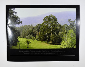
Book - Paperback booklet, Elizabeth Mary Amos, Marysville Community Golf and Bowls Club Inc.-Before and After Black Saturday, February 7, 2009, 2011
This book was created to document through photographs, the history of the Marysville Community Golf and Bowls Club both before and after the Black Saturday Bushfire of 7th February, 2009.Front cover has a photograph taken of one of the greens at the Marysville Community Golf Course. Back cover has a photograph of a red toadstool.non-fictionThis book was created to document through photographs, the history of the Marysville Community Golf and Bowls Club both before and after the Black Saturday Bushfire of 7th February, 2009.marysville community golf and bowls club, golf, bowls (game), marysville, black saturday bushfires, 2009, wildfires, victoria, history -
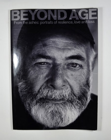 Marysville & District Historical Society
Book, Murrindindi Shire Council, Beyond Age-From the ashes: portraits of resilience, love and loss, 2011
... bushfire photographs portraits victoria The devastating Victorian ...The devastating Victorian bushfires of February 2009 claimed the lives of 173 people. Since then, residents and property-owners throughout the Shire of Murrindindi have rallied together to reclaim their homes, their communities, their relationships and the landscapes they love. Many of them are senior citizens, who have demonstrated through their resilience, wisdom and sense of humour that age often means nothing more than numbers. From CFA volunteers to church-wardens, shearers to scone-makers, older members of the Shire of Murrindindi continue to play their parts in helping communities rise from the ashes. These are their portraits-and some of their stories.Front cover has a black and white photograph of a bearded man whose story is in the book. The back cover has a photograph of a man with his back to the camera and the blurb about the book.non-fictionThe devastating Victorian bushfires of February 2009 claimed the lives of 173 people. Since then, residents and property-owners throughout the Shire of Murrindindi have rallied together to reclaim their homes, their communities, their relationships and the landscapes they love. Many of them are senior citizens, who have demonstrated through their resilience, wisdom and sense of humour that age often means nothing more than numbers. From CFA volunteers to church-wardens, shearers to scone-makers, older members of the Shire of Murrindindi continue to play their parts in helping communities rise from the ashes. These are their portraits-and some of their stories.black saturday, bushfire, photographs, portraits, victoria -
 Marysville & District Historical Society
Book - Paperback booklet, Elizabeth Mary Amos, Marysville Community Golf and Bowls Club Inc.-Before and After Black Saturday, February 7, 2009, 2011
This book was created to document through photographs, the history of the Marysville Community Golf and Bowls Club both before and after the Black Saturday Bushfire of 7th February, 2009.Front cover has a photograph taken of one of the greens at the Marysville Community Golf Course. Back cover has a photograph of a red toadstool.non-fictionThis book was created to document through photographs, the history of the Marysville Community Golf and Bowls Club both before and after the Black Saturday Bushfire of 7th February, 2009.marysville community golf and bowls club, golf, bowls (game), marysville, black saturday bushfires, 2009, wildfires, victoria, history -
 Marysville & District Historical Society
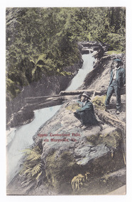
Postcard (item) - Colour tinted postcard, Victorian Stamp Market, Upper Cumberland Falls, via Marysville, Vic, 1908
... saturday bushfires 1939 bushfires eucalyptus regnans victorian ...An early colour tinted photograph of the Upper Cumberland Falls near Cambarville in Victoria. This postcard was published by Victorian Stamp Market as a souvenir of Marysville. An early colour tinted photograph of the Upper Cumberland Falls near Cambarville in Victoria. These falls are located on the Marysville-Wood's Point Road. Cambarville is notable for its giant mountain ash (Eucalyptus regnans) trees within the Cumberland Memorial Scenic Reserve, and relics from former sawmills and gold mining. The Big Culvert is located nearby on the Marysville - Woods Point Road, which was historically part of the Yarra Track. Cambarville was established as a timber mill town in the 1940s. Timber mill owners A Cameron and FJ Barton named Cambarville. They established the mill to salvage timber from trees destroyed in the 1939 bushfires. Cambarville was impacted by the 2009 Black Saturday bushfires and any remaining structures were destroyed.POST CARD This space may be used for Correspondence. FOR ADDRESS ONLY Printed in Germany V.S.M. Seriescumberland falls, cambarville, marysville, victoria, waterfalls, postcard, souvenir, mountain ash, mining, timber mills, big culvert, yarra track, a cameron, fj barton, black saturday bushfires, 1939 bushfires, eucalyptus regnans, victorian stamp market, victorian stamp market series -
 Marysville & District Historical Society
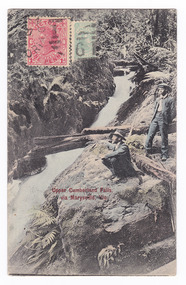
Postcard (item) - Colour tinted postcard, Victorian Stamp Market, Upper Cumberland Falls via Marysville, Vic, 1908
... saturday bushfires 1939 bushfires eucalyptus regnans victorian ...An early colour tinted photograph of the Upper Cumberland Falls near Cambarville in Victoria. This postcard was published by Victorian Stamp Market as a souvenir of Marysville. An early colour tinted photograph of the Upper Cumberland Falls near Cambarville in Victoria. These falls are located on the Marysville-Wood's Point Road. Cambarville is notable for its giant mountain ash (Eucalyptus regnans) trees within the Cumberland Memorial Scenic Reserve, and relics from former sawmills and gold mining. The Big Culvert is located nearby on the Marysville - Woods Point Road, which was historically part of the Yarra Track. Cambarville was established as a timber mill town in the 1940s. Timber mill owners A Cameron and FJ Barton named Cambarville. They established the mill to salvage timber from trees destroyed in the 1939 bushfires. Cambarville was impacted by the 2009 Black Saturday bushfires and any remaining structures were destroyed.POST CARD This space may be used for Correspondence. FOR ADDRESS ONLY Printed in Germany V.S.M. Series WOOD / VICT/ A/ 10 -4.S.10-3/ DISTRIBUZIONS JWO Gricardi/ Via Galletti/ V 16/ Loruis/ Italy Mary A????/ Australiacumberland falls, cambarville, marysville, victoria, waterfalls, postcard, souvenir, mountain ash, mining, timber mills, big culvert, yarra track, a cameron, fj barton, black saturday bushfires, 1939 bushfires, eucalyptus regnans, victorian stamp market, victorian stamp market series