Showing 118 items matching "yarra dam"
-
 Eltham District Historical Society Inc
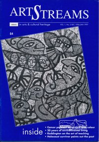
Journal, Peter Doughtery, ArtStreams: News in arts and cultural heritage; Vol. 1, No. 2, Dec 1996/Jan 1997, 1996
... Creek, Wayne Marnell, Woody Guthrie, Yarra Brae Dam, Yarra River... Creek, Wayne Marnell, Woody Guthrie, Yarra Brae Dam, Yarra River ...Vol. 1, No. 2 Dec 1996/Jan 1997 CONTENTS ADVENTURE WITH COLOUR Teenage cancer patients challenge their illness with art 3 CD REVIEWS New music by local musicians 5 LIVE AND LET LIVE 20 years of environmental living 6 AUSTRALIA REVISITED Artist Charles Reddington ponders live 30 years on 8 POETRY REVIEW Anne Delaney looks at new work by Jennifer Harrison and Jordie Albiston 11 PHOTOGRAPHY Katherine Jones aims at hard edges 16 IMAGES FROM A DARK PAST Holocaust survivor paints out a traumatic part of his life 18 MORALITY OF JUSTICE The Truth Game - a play by Ray Mooney 21 ART FROM THE HEART An exhibition that crosses boundaries 22 SHORT STORY New story from an emerging writer 25 ART IN THE CEMETERY Darebin launches a new project to decorate its new mausoleum 28 LISTINGS Artists, performers and galleries 29 KEYWORDS 895 Main Road, 1994 Moet et Chandon Fellowship, Adventure with Colour, Alan Bonney, Alan Constable, Alun Leach-Jones, Amada Laming, Anne Connor & Associates, Anne Delaney, Anthony Day, Art Streams Magazine, Artist-in-residence, Arts by the Waters, Arts project Australia, Auschwitz, Banyule Jazz Festival, Barbara Veheary, Bend of Islands Conservation Association (BICA), Bend of Islands Estate, Bend of Islands, Bill Downing, Bulleen Art & Garden Centre, Bulleen Nursery, Caffe Poco, Carlton Courthouse Theatre, Catani Boulevard, Catherine Oxley Reserve, Charles Reddington, Charlie Dowley, Cheryl Daye, Chris McAuliffe, Clifton Pugh, Colin Lanceley, Cornelia Selover, Creativitie et Handicap Mental (CREAHM), Cynthia Hardman, Cyril Tawney, Damian Eyre, Daniel Lillford, Danuta Michalska, Darebin Arts and Entertainment Centre, Darebin City Council, Department of Fine Arts, Donald Campbell, Dora Zable, Dorothy Berry, dunmoochin, E.H. Cameron, Edward (Ned) Haughton, Edward Car, Elizabeth Vercoe, Eltham High School, Eltham Living and Learning Centre, Environmental Living Zone (ELZ), Eric Bogle, Eucalypso, Felix Tuszynski, Food For All Seasons, Frank Hodgkinson, Fulli Andrinopoulos, Gallery of Georges of Collins Street, Gallery of Slavic Art, Glen Agnes Bend of Islands Estate, Glen Agnes Estate, Gongflers drive, Greg O'Leary, Harold (Jimmy) Fuller, Helen O'Grady Children's Drama Academy, Henley Road, Ian Doolan Hamilton, Ian Gawler, Inside Out/Outside In, Ironbark Road, Janice McBride, Jennifer Harrison, Jennifer McGregor, Jessie Agnes Haughton, Jimmy Pike, Joan Blakey, John Mackay Northe, John Rasmussen, Jordie Albiston, Julian Martin, Kangaroo Ground, Katherine Jones, Kelvin Heffernan, Kew Coattage, Kitty Ginter, Lavita Mossop, Les darcy, Les Gyori, Life with Jane, Lorraine Larter, Luc Boulange, Luciana Giardina, Manningham Artspace, Manningham City Council, Mariann Moxon, Mark Capozzi, Mark Chapman, Mark Wilkinson, Maxine Ryder, Melbourne Police Pipe Band, Mick Woiwod, Mike O'Rourke, Monica Burns, Montsalvat, Myra Hilgendorf, Nancye Ball, Page family, Pam Crohan, Pam Dougherty, Poetry, Preston Public Cemetery, Ray Mooney, Richard Haese, Robert Hughes, Robyn Kirkpatrick, Roger Lemke, Ron Hanson, Sandra Harvey, Shire of Eltham Office site, Shire of Healesville, Shire of Nillumbik, Shire Offices, Sounds by the Waters, Stelio Costa, Steven Tynan, Steven Worrell, Stewart Whiffin, Sue Howard, Sue Whiffin, Sugarloaf Reservoir, Sydney Ball, The Art of Australia, The Mews, The Truth Game, Tom Fantl, Tony Inglese, Tuszynski Survey Exhibition, University of Melbourne, Valerio Ciccone, victorian artists supplies, Watson Creek Bridge, Watsons Creek, Wayne Marnell, Woody Guthrie, Yarra Brae Dam, Yarra River"Peter Dougherty has been involved in the local art scene for many years. As publisher and editor of the arts magazine Artstreams, his comments on the various branches of the arts are widely respected. His "The Arts" column in the Diamond Valley Leader presents a brief summary for a much wider cross section of the local community. Peter also operates his own gallery and the Artstreams Cafe at the St Andrews market. Peter has a wealth of knowledge about present day and historical aspects of local art and artists." - Eltham District Historical Society Newsletter No. 161, March 2005Colour front and back cover with feature articles and literary pieces with photographs and advertisements printed in black and white. 36 pages, 30 cm. Vol. 1, no. 1 (Nov. 1996) - Vol. 10, no. 5 (summer ed. 2005/06) art streams, feliz tuszynski, elizabeth vercoe, eucalypso, bend of islands, charles reddington, jennifer harrison, jordie albiston, katherine jones, anne bonney, mick woiwood, anne connor, anne delaney, ray mooney, pam dougherty, arts project australia, lavita mossop, preston public cemetery, helen o'grady children's drama academy, bulleen nursery -
 Eltham District Historical Society Inc
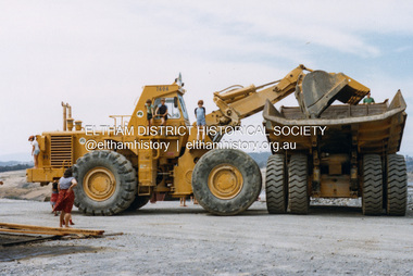
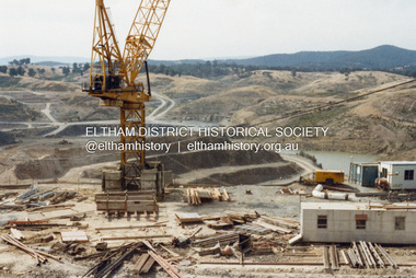
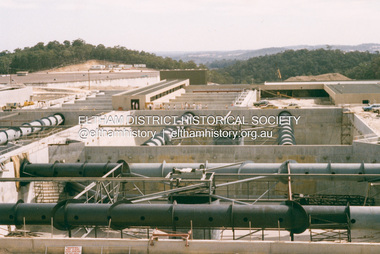
Photograph - Colour Print, Lewis Tulk, Construction Winneke Reservoir and treatment plant / Melbourne and Metropolitan Board of Works, c.1981
Sugarloaf Reservoir is situated on former farmland. This large water storage was completed in 1982 and serves Melbourne's northern suburbs. Within the visitor areas are two picnic grounds and other recreational facilities. Below its massive rock embankment is located the Winnecke Treatment Plan designed to purify its water before being piped into Melbourne. The dam partly inundated the old firing ranges of the former Christmas Hills Rifle Club. Source: Christmas Hills Now and then: Yarra Glen & District Historical Society, 2004.lewis tulk collection, construction, sugarloaf reservoir, winnecke dam -
 Eltham District Historical Society Inc
Film - Video (VHS), IMP Productions, The Shire of Etham - The Evergreen Shire (Series 69, Item 4), c.1985
Shire of Eltham Archives: Series 69, Item 4 This video was produced for the Shire of Eltham by IMP Productions and provides a description of the shire, 277 square km on a north/northeast axis, some 25 km northeast of the centre of Melbourne with a population of around 40,000. Scenes include Yarra River, rural settings and urban settings, housing estates, Shillinglaw Cottage, Pigeon Bank at Kangaroo Ground, the Eltham Railway Trestle Bridge with reference to the fight by locals in the 1970s to save it from replacement, Montsalvat, mudbrick making and its use as a building material, the use of mudbrick in the Eltham Community Centre blending harmoniously with the environment. Emphasises people living in the area due to the qualities of life provided. Also the Living and Learning Centre, St Andrews Markets and other local markets, the Eltham Leisure Centre, cricket and horse riding at Eltham Lower Park, the Infant Welfare Centre (part of the Eltham War Memorial), how residents are mindful of protecting their historical heritage, the CBA bank and Allwood House at Hurstbridge, Tracey Naughton about the Eltham "As we are" Community Banner project and the “River of Life banner”, the Parks and Gardens office in the former Police Residence building (now the Local History Centre), Alistair Knox Park, road planning and types of roads, tree canopy, Peck's Dam, green carparks, road drainage, Gordon Ford's garden and natural landscapes, and Were Street shops in Montmorency. Planning for shopping facilities and carparks with a population of 40,000 growing to 55,000, Arthur Street Mall and carpark, local village feel in the shopping centre. Councillors and Council staff featured include Mary Grant, Bob Manuell, Rodney Roschellor, John Cohen, Alan Baker. Also scenes of Commercial Place, Diamond Valley Railway, Eltham Galley, Riverclay and canoeing on the Yarra intermingled with images of the shire from the Shire of Eltham Pioneers Photograph collection.VHS Video cassette Converted to MP4 file format 00:11:56; 79MBshire of eltham, video recording, shire of eltham archives, alistair knox park, allwood house, arthur street, arthur street mall, bob manuell, canoeing, carparks, cba bank, commercial place, council staff, councillors, cr. mary grant, cricket, diamond valley railway, eltham community banner project, eltham community centre, eltham galley, eltham leisure centre, eltham living and learning centre, eltham lower park, eltham railway trestle bridge, eltham war memorial, gordon ford garden, horse riding, housing estates, hurstbridge, infant welfare centre, john cohen, kangaroo ground, local history centre, montmorency, montsalvat, mudbrick, parks and gardens, peck's dam, pigeon bank, police residence, river of life banner, riverclay, road drainage, road planning, rodney roschellor, shillinglaw cottage, shire of eltham pioneers photograph collection, st andrews market, tracey naughton, tree canopy, were street, yarra river, alan baker -
 Marysville & District Historical Society
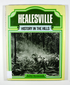
Book, Healesville-History in the Hills, 1982
A history of HealesvilleHardcover. Front cover of dust jacket has a photograph of a bullock team hauling a load of timber. Back cover of dust jacket has a photograph of the Maroondah Dam.Stamp of the Marysville & District Historical Society Inc / P.O. Box 22 / Marysville 3779 R. Whitford For/ MANDY/ whose love of the bush/ brought us to Healesvillehealesville, upper yarra valley, victoria, australia, sally symonds, history -
 Marysville & District Historical Society
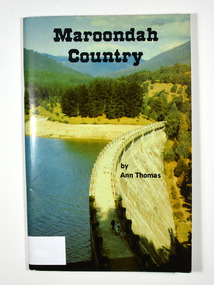
Book, Maroondah Country, 1979
A history of the Maroondah ReservoirPaperback. Front cover shows a colour photograph of the Maroondah Dam wall. Back cover shows a black and white photograph of the Maroondah Dam under construction.Madge Stevens / 85 Rose Street / West Coburg From Mena & Bill on / birthday 5.9.82 AN APPRECIATION Living all my earlier life at my birth-place, Heales-/ ville, with my sisters and brothers and our good parents,/ it was a privilege to return and re-acquaint during the/ collecting of these few impressions of the old times./ Thanks are due to the obliging attendants at MMBW/ and LaTrobe libraries, where frequent checks of old/ newspapers - including "The Healesville & Yarra Glen/ Guardian" - and records were essential./ Thanks also to my friends, and cousin Dave./ Ann Thomas Stamp of Marysville & District / Historical Society Inc / P.O. Box 22 / Marysville 3779maroondah dam, maroondah, fernshawe, healesville, maroondah aqueduct, maroondah reservoir, victoria, history -
 Marysville & District Historical Society
Photograph (item) - Black and white photograph, Unknown
A black and white photograph which shows a group of men constructing the form work for the dam at the base of Steavenson Falls.A black and white photograph shows a group of men constructing the form work for the dam at the base of Steavenson Falls. Steavenson Falls provides Marysville with the town's drinking water which is considered to be the second-best drinking water in the world. The Steavenson Falls are named after the Victorian Assistant Commissioner of Roads and Bridges, John Steavenson who arrived in Victoria in the early 1860s.steavenson falls, marysville, victoria, waterfalls, john steavenson, 2009 black saturday bushfires -
 Eltham District Historical Society Inc
Photograph, The Leader, The "Black Swan" Mine and "The Old Dam", Warrandyte Gold Fields, 1897
Reproduced from "The Leader" 14th Aug. 1897, page 7 The "Black Swan" mine - on Captain Selby's property of 200 acres. Discovered by Captain Selby 8 years ago. He is working it himself. 'The shaft is down 70 feet and with deeper sinking the reef is found to increase in width. Nearly £2,000 has been obtained from this mine, the gold being of high quality, fetching £4-1-6 per oz.' Warrandyte photo "The Old Dam" - erected accross the river by Mr John Wallace, M.L.C., who attempted to turn the river and to work the river bed.This photo forms part of a collection of photographs gathered by the Shire of Eltham for their centenary project book,"Pioneers and Painters: 100 years of the Shire of Eltham" by Alan Marshall (1971). The collection of over 500 images is held in partnership between Eltham District Historical Society and Yarra Plenty Regional Library (Eltham Library) and is now formally known as the 'The Shire of Eltham Pioneers Photograph Collection.' It is significant in being the first community sourced collection representing the places and people of the Shire's first one hundred years.Digital imagesepp, shire of eltham pioneers photograph collection, warrandyte, gold mining, black swan mine, old dam -
 Eltham District Historical Society Inc
Photograph, Remains of the old Water Wheel and Battery, Warrandyte, 1934
A short distance upstream from the old wooden Warrandyte Bridge, the Yarra river was at one time dammed to give power to a large wooden waterwheel which drove a plant for crushing gold. Up until around 1908 the waters of the Yarra, pent up by a stone weir, forced their way past this old wheel turning it to crush the precious quartz. In 1925 the reamins of the State Battery were removed. The large water wheel (thanks to the forethought of a local resident, Mr. P. Mackie) was left in its position.This photo forms part of a collection of photographs gathered by the Shire of Eltham for their centenary project book,"Pioneers and Painters: 100 years of the Shire of Eltham" by Alan Marshall (1971). The collection of over 500 images is held in partnership between Eltham District Historical Society and Yarra Plenty Regional Library (Eltham Library) and is now formally known as the 'The Shire of Eltham Pioneers Photograph Collection.' It is significant in being the first community sourced collection representing the places and people of the Shire's first one hundred years.Digital image 4 x 5 inch B&W Negshire of eltham pioneers photograph collection, warrandyte, water wheel, caledonia battery, state battery, warrandyte battery -
 Eltham District Historical Society Inc
Photograph, 35 Ingrams Road, Research, Eltham Heritage Tour, 24 May 1992, 24/05/1992
ELTHAM HERITAGE TOUR The Society excursion on 24th May 1992 was arranged by David Bick, leader of the team carrying out the Shire's heritage study. David selected a number of sites or buildings identified in the study, some of them lesser known components of the Shire's heritage. The tour commenced at the Eltham Shire Office at 10.00 am. Travel was by private car and mini-bus with stops at about twelve locations for commentary by David.It included a short walk in Hurstbridge and lunch at Kinglake. Highlights of the tour included: - 10 am Leave from Shire Offices - 3 Important Trees - A Physical Link to Eltham's First Settlers - Toorak Mansion Gates - A Surviving Farm House - An Intact Circa 1900 Main Street - First Settlers - Gold Miners, and Timber-getters - An Early Hotel - A Pioneering Homestead - Changing Eltham Shire - 20th Century - 4 pm Afternoon Tea and Finish Tour Extract from ELTHAM CULTURAL HERITAGE TOUR (Newsletter No. 85, July 1992, by Bettina Woodburn) "On a right-angle turning of the Eltham Road is Wellers Pub, a Cobb & Co. coaching stop on the way to distant gold-fields and places north of the Yarra River. The Hotel dates from the 1870's. Daily distances for a bullock team was eight miles, horses could do double that distance. We turned into Cassells Road and on the corner of Ingrams Road we admired an elaborate Edwardian villa, 1900 style. The Aqueduct conveying Melbourne's water supply was a communication line and a technological advance in 1891. It has been enlarged and re-faced and no longer used here but piped underground. Proclaimed a linear park it has reverted to crown land, controlled by local Council. Maroondah Dam was constructed in. 1920 to replace the original weir and at that time: the Aqueduct - as established into the landscape - with bridges and tunnels and pine trees were used to stop rubbish polluting the water."Record of the Society's history and activities and highlighting various aspects of the Heritage Study undertaken by David Bick used to create the future heritage overlay for the Shire of Eltham and later Nillumbik Shire.Roll of 35mm colour negative film, 4 stripsKodak Gold 100 5095shire of eltham historical society, activities, heritage tour, ingrams road, research (vic.) -
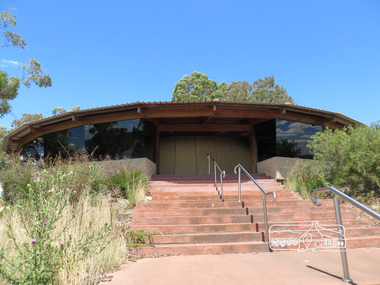
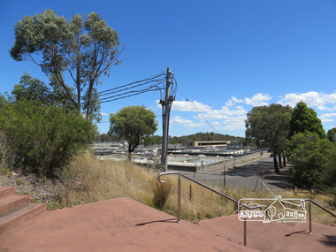
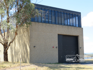
 Eltham District Historical Society Inc
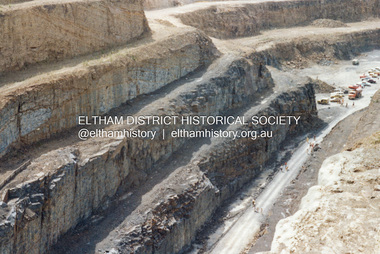
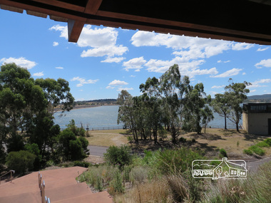
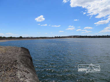
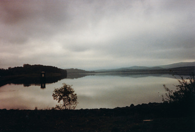
Photograph, Sugarloaf Reservoir, Christmas Hills, 16 January 2015, 16 January 2015
Sugarloaf Reservoir is situated on former farmland. This large water storage was completed in 1982 and serves Melbourne's northern suburbs. Within the visitor areas are two picnic grounds and other recreational facilities. Below its massive rock embankment is located the Winnecke Treatment Plan designed to purify its water before being piped into Melbourne. The dam partly inundated the old firing ranges of the former Christmas Hills Rifle Club. Source: Christmas Hills Now and then: Yarra Glen & District Historical Society, 2004. Born Digitalchristmas hills, sugarloaf reservoir -
 Eltham District Historical Society Inc
Photograph, Sugarloaf Reservoir, Christmas Hills, 16 January 2015, 16 January 2015
Sugarloaf Reservoir is situated on former farmland. This large water storage was completed in 1982 and serves Melbourne's northern suburbs. Within the visitor areas are two picnic grounds and other recreational facilities. Below its massive rock embankment is located the Winnecke Treatment Plan designed to purify its water before being piped into Melbourne. The dam partly inundated the old firing ranges of the former Christmas Hills Rifle Club. Source: Christmas Hills Now and then: Yarra Glen & District Historical Society, 2004. Born Digitalchristmas hills, sugarloaf reservoir -
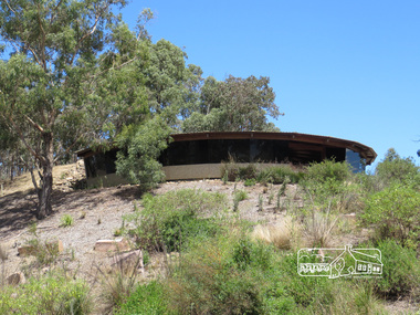
 Eltham District Historical Society Inc
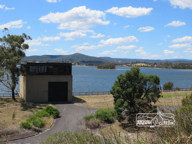
Photograph, Sugarloaf Reservoir, Christmas Hills, 16 January 2015, 16 January 2015
Structure at Sugarloaf. Sugarloaf Reservoir is situated on former farmland. This large water storage was completed in 1982 and serves Melbourne's northern suburbs. Within the visitor areas are two picnic grounds and other recreational facilities. Below its massive rock embankment is located the Winnecke Treatment Plan designed to purify its water before being piped into Melbourne. The dam partly inundated the old firing ranges of the former Christmas Hills Rifle Club. Source: Christmas Hills Now and then: Yarra Glen & District Historical Society, 2004. Born Digitalchristmas hills, sugarloaf reservoir -
 Eltham District Historical Society Inc
Photograph, Sugarloaf Reservoir, Christmas Hills, 16 January 2015, 16 January 2015
Sugarloaf Reservoir is situated on former farmland. This large water storage was completed in 1982 and serves Melbourne's northern suburbs. Within the visitor areas are two picnic grounds and other recreational facilities. Below its massive rock embankment is located the Winnecke Treatment Plan designed to purify its water before being piped into Melbourne. The dam partly inundated the old firing ranges of the former Christmas Hills Rifle Club. Source: Christmas Hills Now and then: Yarra Glen & District Historical Society, 2004. Born Digitalchristmas hills, sugarloaf reservoir -
 Eltham District Historical Society Inc
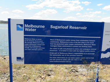
Photograph, Sugarloaf Reservoir, Christmas Hills, 16 January 2015, 16 January 2015
Sugarloaf Reservoir is situated on former farmland. This large water storage was completed in 1982 and serves Melbourne's northern suburbs. Within the visitor areas are two picnic grounds and other recreational facilities. Below its massive rock embankment is located the Winnecke Treatment Plan designed to purify its water before being piped into Melbourne. The dam partly inundated the old firing ranges of the former Christmas Hills Rifle Club. Source: Christmas Hills Now and then: Yarra Glen & District Historical Society, 2004. Born DigitalMelbourne Water Sugarload reservoir Melboure Water is owned by the Victorian Government. We manage Melbourne's water supply catchments, remove and treat most of Melbourne's sewrage, and manage waterways and major drainage systems. Most of Melbourne's water comes from uninhabited, forested catchments. Melbourne is one of the few cities in the world that has protecyed water supply catchments. Melbourne Water manages these catchments to protect our drinking water. Our water is safe and pleasant to drink, and undergoes minimal treatment - it is better to start witht he highest quality source. A key part of Melbourne Water's responsibility is to encourage the sustainable use of this precious resource. For more inforamtio on our water supply and on how you can conserve water, call 131 722 or visit www.melbournewater.com.auchristmas hills, sugarloaf reservoir, sign, melbourne water -
 Eltham District Historical Society Inc
Photograph, Sugarloaf Reservoir, Christmas Hills, 16 January 2015, 16 January 2015
Sugarloaf Reservoir is situated on former farmland. This large water storage was completed in 1982 and serves Melbourne's northern suburbs. Within the visitor areas are two picnic grounds and other recreational facilities. Below its massive rock embankment is located the Winnecke Treatment Plan designed to purify its water before being piped into Melbourne. The dam partly inundated the old firing ranges of the former Christmas Hills Rifle Club. Source: Christmas Hills Now and then: Yarra Glen & District Historical Society, 2004. Born Digitalchristmas hills, sugarloaf reservoir, signage -
 Eltham District Historical Society Inc
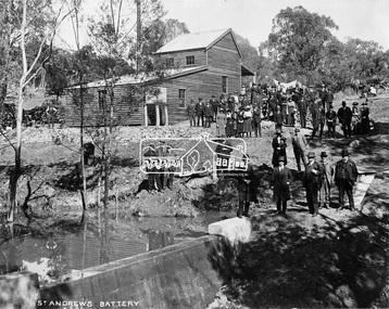
Negative - Photograph, Opening of St. Andrews Battery, Queenstown, 29 Aug. 1919
Reproduced on p31 of 'Pioneers & Painters' Was destroyed in 1962 bushfire. Now Peter Franks Reserve, St Andrews On Friday 29th (August 1919) …, the Hon. S. Barnes, M. L. A., Minister of Mines, accompanied by Mr W. Everard, M.L.A., Mr. V. Dickson, secretary for Mines, and Mr. Merrin, Chief Mining Inspector, visited Smith's Gully for the purpose of opening, the new Government battery which has recently been erected. The party arrived punctually at 12.30, and was received by an assemblage of about 200 residents, including, those representing local prospecting and mining interests. At the mill house the Minister wished prosperity to mining on the old Queenstown field, and, in a few appropriate remarks, gave the battery the name of St. Andrew's. Then, as the stamps began to fall, three hearty cheers were given by the gathering. ….. The Queenstown field, dating back to the early sixties, might be regarded as a link that took them back to the Augustine age of gold mining in Victoria…From 1868 to 1918 the total yield of gold from the field was 274,606 fine oz. It might be that here, as elsewhere, deeper prospecting would give new life to the Queenstown goldfield. The miners of Queenstown, who through long year's had never lost faith in the possibilities of the field, felt that the purpose for which they were that day marked the beginning of a new era in the history of local reefing. …. The new mill is situated on the bank of the creek opposite the Queenstown Cemetery, and consists of a five head battery (Berdan pan) and 12 h.p. portable steam engine housed in a spacious structure of wood and iron. A concrete weir across the creek provides a good water supply, and all the necessary pumps, settling dams, etc., have been installed. Later on, should circumstances warrant it, it is pro-posed to erect Wilfley tables for concentrates. Eltham and Whittlesea Shires Advertiser and Diamond Creek Valley Advocate, Friday 5 September 1919, page 3This photo forms part of a collection of photographs gathered by the Shire of Eltham for their centenary project book,"Pioneers and Painters: 100 years of the Shire of Eltham" by Alan Marshall (1971). The collection of over 500 images is held in partnership between Eltham District Historical Society and Yarra Plenty Regional Library (Eltham Library) and is now formally known as the 'The Shire of Eltham Pioneers Photograph Collection.' It is significant in being the first community sourced collection representing the places and people of the Shire's first one hundred years.Digital image 4 x 5 inch B&W Neg Print 20 x 25 (2)shire of eltham pioneers photograph collection, queenstown, st andrews, st. andrews battery, gold mining, s. barnes, merrin, st andrews battery, v. dickson, william h. everard, peter franks reserve -
 Eltham District Historical Society Inc
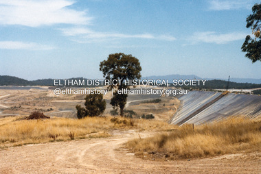
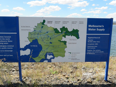
Photograph, Sugarloaf Reservoir from Skyline Drive, 1989, 1989
Originally contained in a 'magnetic' photo album believed to have been donated by Mr Eric Stephenson, Jingalong, 110 Ryans Road, Eltham, Vic. 3095; relocated to archival safe storage. Sugarloaf Reservoir is situated on former farmland. This large water storage was completed in 1982 and serves Melbourne's northern suburbs. Within the visitor areas are two picnic grounds and other recreational facilities. Below its massive rock embankment is located the Winnecke Treatment Plan designed to purify its water before being piped into Melbourne. The dam partly inundated the old firing ranges of the former Christmas Hills Rifle Club. Source: Christmas Hills Now and then: Yarra Glen & District Historical Society, 2004. Two colour photographsskyline drive, sugarloaf reservoir -
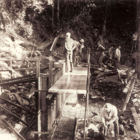
 Eltham District Historical Society Inc
Negative - Photograph, Carl Walter 1831-1907, Coffer dam in the Yarra River at Anderson's Creek, 1864
... Coffer dam in the Yarra River at Anderson's Creek...1864 photograph of the Coffer Dam in the River Yarra... melbourne 1864 photograph of the Coffer Dam in the River Yarra ...1864 photograph of the Coffer Dam in the River Yarra situated (approximately) opposite Whipstick Gully. Remains of bridge built in 1860(?) wrecked by 1863 flood in background. Reproduced page 29 of ‘Pioneers & Painters’ Gold was first discovered in this area at Andersons Creek (Warrandyte) in June 1851 by Louis Michel. Discoveries north of the Yarra did not occur until about 1854. Although it took some months for a true rush to develop it was not long before alluvial workings were being carried on in most of the Shire of Eltham. The last area in which gold was discovered was Kinglake. As the gold became harder to find, deep mining took over from alluvial diggings in the gullies. Perhaps the most extensive of the deep workings was the Diamond Creek Mine just outside the boundary of the Shire. This form of mining was continued into the 1930s. There are believed to be some mines in the area still capable of producing gold but present prices make working these uneconomical. Some gold is still found by weekend prospectors. Photo: Carl Walter 1831-1907 – inscribed on tent “C. Walter Photo” The State Library of Victoria holds over 150 photos by Carl Walter, most of which are portraits of Aboriginal natives including William Barak.This photo forms part of a collection of photographs gathered by the Shire of Eltham for their centenary project book,"Pioneers and Painters: 100 years of the Shire of Eltham" by Alan Marshall (1971). The collection of over 500 images is held in partnership between Eltham District Historical Society and Yarra Plenty Regional Library (Eltham Library) and is now formally known as 'The Shire of Eltham Pioneers Photograph Collection.' It is significant in being the first community sourced collection representing the places and people of the Shire's first one hundred years.Digital image 4 x 5 inch B&W Neg (2) Print 20 x 25 cmshire of eltham pioneers photograph collection, anderson's creek, coffer dam, floods, gold mining, other areas, pioneers and painters, warrandyte, warrandyte bridge, yarra river -
 Monbulk RSL Sub Branch
Book, Paul Brickhill, The dam busters, 1953
On 17 May 1943, nearly 350 million tons of water crashed into the valleys of the Ruhr when the Lancaster bombers of 617 Squadron breached the giant Moehne and Eder Dams with colossal ‘blockbuster’ bombs. The Dam Busters tells the story of the raid and the squadron of fearless airmen who carried it through. Again and again, the crews of 617 Squadron Bomber Command used their flying skills, their tremendous courage and Barnes Wallis’ highly accurate bouncing bombs to deal devastating blows to Nazi Germany.Ill, p.287.non-fictionOn 17 May 1943, nearly 350 million tons of water crashed into the valleys of the Ruhr when the Lancaster bombers of 617 Squadron breached the giant Moehne and Eder Dams with colossal ‘blockbuster’ bombs. The Dam Busters tells the story of the raid and the squadron of fearless airmen who carried it through. Again and again, the crews of 617 Squadron Bomber Command used their flying skills, their tremendous courage and Barnes Wallis’ highly accurate bouncing bombs to deal devastating blows to Nazi Germany. world war 1939-1945 - aerial operations - britain, dam buster raid - germany -
 Monbulk RSL Sub Branch
Book, Readers book club, The dam busters, 1954
On 17 May 1943, nearly 350 million tons of water crashed into the valleys of the Ruhr when the Lancaster bombers of 617 Squadron breached the giant Moehne and Eder Dams with colossal ‘blockbuster’ bombs. The Dam Busters tells the story of the raid and the squadron of fearless airmen who carried it through. Again and again, the crews of 617 Squadron Bomber Command used their flying skills, their tremendous courage and Barnes Wallis’ highly accurate bouncing bombs to deal devastating blows to Nazi Germany.Ill p.254.non-fictionOn 17 May 1943, nearly 350 million tons of water crashed into the valleys of the Ruhr when the Lancaster bombers of 617 Squadron breached the giant Moehne and Eder Dams with colossal ‘blockbuster’ bombs. The Dam Busters tells the story of the raid and the squadron of fearless airmen who carried it through. Again and again, the crews of 617 Squadron Bomber Command used their flying skills, their tremendous courage and Barnes Wallis’ highly accurate bouncing bombs to deal devastating blows to Nazi Germany.world war 1939 – 1945 – britain – aerial operations - europe, royal air force - 617 squadron -
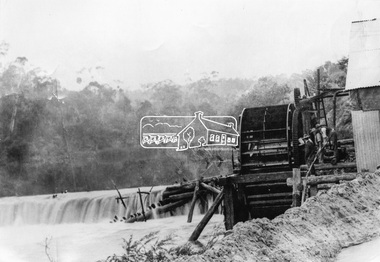
 Melbourne Water
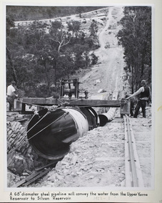
Photograph - Steel Pipeline, 1952
The Upper Yarra Reservoir supplies the Silvan Reservoir, which distributes water throughout the Melbourne metropolitan area. The dam was completed in 1957 and is a rolled earthfill and rockfill embankment. This photograph shows a 68" diameter steel pipeline that was to convey the water from the Upper Yarra Reservoir to the Silvan Reservoir.This photograph is significant as it provides a detailed insight into the Boards activity and construction of one of Melbourne's most important water supply systems. Furthermore, it is of historical importance to the history of Melbourne while it is representative of shaping Melbourne's environments, transforming and managing land and natural resources, and providing urban infrastructure and services. The photograph itself is aesthetically pleasing, through its depth of field and use of shape with an interesting composition. Black and white photographmmbw, melbourne metropolitan board of works, melbourne water, upper yarra reservoir, silvan reservoir, water, waterway, dam -
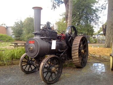 Puffing Billy Railway
Vehicle - Traction Engine - Foden Compound, 1914
Ordered by Langwill Bros., & Davies Ltd Melbourne Used for saw milling, dam constructions and log haulingFoden Traction Engine This engine is a compound traction engine built by Foden Ltd of Sandbach England in 1914 – builders number 4525. This was ordered by Langwill Bros and Davies Ltd of Melbourne and was used by Mr F Orr on his farm at Bullarto South Victoria. On the farm it was used for many agricultural purposes and was used at times as a stationary engine to run a wooden thrashing machine. The unit was last used on the farm in 1947 and put aside on the farm with a “museum” of other old agricultural tractors and machinery. Mr Orr gave us the engine as an exhibit for the Menzies Creek Museum of Puffing Billy in the 1960s. At that stage he was an elderly gentleman of 97 years and maintained a great interest in his farm which had been in his family’s hands for three generations at that stage. His grandfather had cut the farm from the bush. The traction engine in its youth was used to go around other farms in the district and went as far away as the Wimmera and Mallee farms thrashing crops of wheat, barley and oats. It towed the wooden thrashing machine behind it on its trips to these farms on hire to the farmers. Foden Compound Traction Engine Built by Foden Ltd., Sandback, England in 1914 to the order of Langwill Bros., & Davies Ltd., Melbourne, it was used on a farm for sawmilling, dam constructions and log hauling. Donated by F. Orr of Bullarto South, Victoria. Foden Compound Traction Engine - made of Steel (Painted)Foden foden, traction engine, steam, puffing billy -
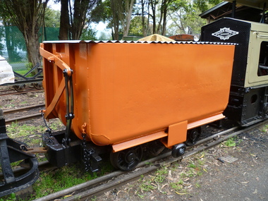 Puffing Billy Railway
Side Tipping Wagon - W. G. Allen & Sons (Tipton) Ltd
Built by W. G. Allen & Sons (Tipton) Ltd., Tipton, Staffordshire, England. This vehicle was used on the construction of dams, etc., and the Jindivick tunnel at Tarago in Gippsland for the state Rivers & Water Supply Commission of Victoria. The small wheel located on the side ran up a suitably located ramp automatically tipping the hopper and emptying the contents. Historic - Industrial Narrow Gauge Railway - side tipping wagon used by the State Rivers & Water Supply Commission of Victoria - Jindivick tunnel at Tarago, Victoria, AustraliaSide Tipping Wagon made of Iron, steel and wrought ironpuffing billy railway, pbr, side tipping wagon - w. g. allen & sons (tipton) ltd, puffing billy, side tipping wagon, w. g. allen & sons (tipton) ltd, jindivick tunnel, state rivers & water supply commission of victoria