Showing 1763 items
matching settlements
-
 Orbost & District Historical Society
magazine, The Gap -1985
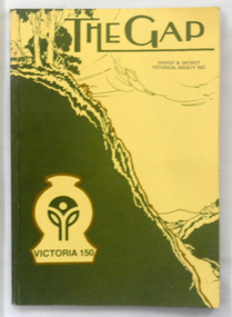
This is a special edition of The Gap to celebrate 150 years of Victorian settlement. The first edition of this magazine was produced by associated elementary schools in the Omeo Shire. The magazine was published from 1920 to 1927 and 1963 to 1969. This is a special issue in 1985. In all issues there is writing by children from schools that have since closed down.This item reflects the changes in education in East Gippsland and is a useful comparison tool for literacy teaching. It also has historical articles for research.A 174 pp magazine with an olive green and cream coloured cardboard cover. On the front is a sketch of a small schoolhouse on a hill overlooking a gap in the hills below. The title, "The Gap" is at the top in green print on a cream background. There is a logo for Victoria 150. It contains historical articles, photographs and examples of children's work. -
 Daylesford & District Historical Society
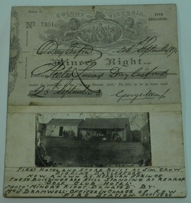
Miner's Right & Photograph, Miner's Right Pietro Lucini, Daylesford and Photograph of first hotel & stores at Jim Crow now Hepburn
Pietro Lucini owned the building on the right in the attached photograph. He operated a general store here prior to building a new building opposite this site. He was involved in gold mining activities in the early settlement of Spring Creek, now known as Hepburn Springs. Dr Francesco operated a store in building on left. A document and photograph glued on cardboard. 01451.1 Miner's Right, No. 7351. Glued on cardboard. 01451.2 A separate photograph of two early stores at early Jim Crow diggings, now Hepburn Springs. Text at bottom of photograph, " First hotel and store built at Jim Crow Diggins Daylesford. Now known as Hepburn Springs. These buildings are still standing at rear of "Golf Club Hotel. Photo Miner's Right donated by Mr J Bramwell Officer in charge of Kew Fire Station. Sept 1936". Back of cardboard has the following writing; "Donated by Mr J Bramwell Officer in Charge of Fire Station, Walton St. Kew. Sept 1936", "Donated by Beryl Jean Frame (per Mrs.R.Bland Ferntree Gully) 1987", "Box 4", WINGRAM 47 Victoria Road Auburn Melb 1- JAN 1940, Daylesford & District Historical Society.gold mining, lucini, buildings, hotel, spring creek, golf club hotel -
 Hume City Civic Collection
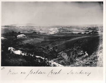
Photograph - View of Jackson Creek Sunbury, c1870
The photograph was taken on a rise overlooking the early settlement of Sunbury with Mount Holden and other hills across the skyline. The five arch railway bridge is visible in the distance on the RHS of the image. Two of Sunbury's early hotels, the John Franklin and the Ball Court are across the middle distance. Craiglee Vineyard with the vines growing is in the foreground. A black and white photograph with a white border.Written across the bottom: VIEW OF JACKSON CREEK SUNBURYsunbury, vineyards, jackson creek, craiglee vineyard -
 Kiewa Valley Historical Society
Sketch Tree Bark, Aboriginal - bark removed from tree
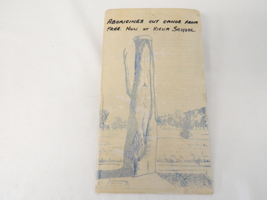
This sketch of a tree whose bark was cut, by aboriginal craftsmen, to produce a canoe for fishing in the rivers running through the Kiewa Valley either before or just after the 1800's. The tree trunk depicted in the sketch would have been used at the beginning of European settlement in the Kiewa Valley or just before contact was made.As this sketch was of a tree found along the Kiewa River it indicates that Aborigines lived by the river. This sketch depicts the usage of tree bark by the Aboriginal fisher person in crafting a canoe to cross rivers and to fish in the deeper sections of the river course.This freehand sketch detailing the outline of bark removed to provide a canoe is in ink portraying a tree trunk with one branch which has a plaque in front a gravel section to the right and open fields in the mid background and scattered trees on a hill slope in the far background. The sketch is on thick cardboard with a plastic protective cover over it (fastened on the flip side). It is a sketch of the tree now exhibited at the Kiewa Consolidated School.Written in black ink on the top section (heading) "ABORIGINES CUT CANOE FROM TREE. NOW AT KIEWA SCHOOL"crafted canoe, aboriginal craftsmanship, tree usage, early aboriginal craftsmen, kiewa river. kiewa consolidated school -
 Mt Dandenong & District Historical Society Inc.
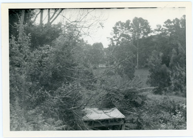
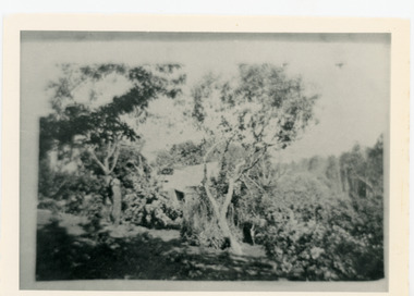
Photograph, View from George Barber's Home To His Stables
John Lundy-Clarke grew up in the Kalorama/Mt Dandenong area and later in life (1972-74) began to write a comprehensive history of the area working from an original settlement map in an effort to cover all areas. This photograph was taken by John Lundy-Clarke in 1973 to show changes to the environment sine 1905.Black and white photograph with tangled bush and small shed in foreground looking towards a cleared area. Handwritten description on reverse written by John Lundy-ClarkeView from Barbers drive to his stables close to where 1905 picture was taken. Stables in foreground. Looking towards Gap. Taken JLC November 1973.barbers road, john lundy-clarke, kalorama -
 Surrey Hills Historical Society Collection
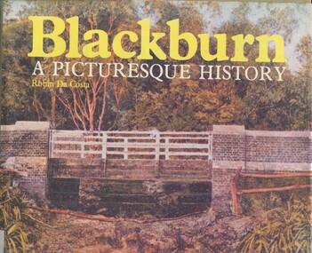
Book, Blackburn: A Picturesque History, 1978
This book focuses on the area's history and traces the development through settlement, adaptation and consolidation to the present. It discusses the history of early families, the railway, land boomers, churches and school. Robin da Costa, later Mrs Robin da Costa- Adams, came to live in Balwyn Road, Canterbury and joined the Canterbury History Group.Hardback book of 144 pages, indexed with multiple black and white photos.In Jocelyn Hall's writing: "Donated to Surrey Hills Neighbourhood Centre".(mr) james blackburn, meader's travellers' rest hotel, blackburn hotel, blackburn post office, blackburn railway station, blackburn pioneers, blackburn company, (mr) george augustus goodwin, (mr) thomas r b morton, blackburn brick works, st john's anglican church, blackburn methodist church, blackburn church of christ, blackburn presbyterian church, st thomas the apostle peace memorial church, seagoe common school, the courier blackburn, blackburn library, blackburn primary school, blackburn open-air school, blackburn creek hotel, blackburn college, blackburn kindergarten, newark grammar, blackburn hall, morton park, blackburn lake sanctuary, backhouse's dairy, blackburn lake, wandinong sanctuary, barelli bakehouse, blackburn cool store, blue moon fruit co-operative ltd, 1st blackburn scouts troop, blackburn and district tree preservation society, hotels, (ms) robin da costa -
 City of Moorabbin Historical Society (Operating the Box Cottage Museum)
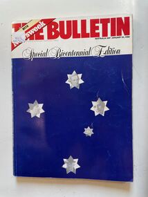
Book, Australian Consolidated Press Ltd, The Bulletin (Special Bicentennial Edition) January 26th.1988, 1988
A large dark blue soft cover book with the the title written in large red letters at the top,on a white stripe underneath this is written Special Bicentennial Edition and under this on the dark blue are five white stars depicting the Southern Cross four of the stars has the face of a historical person on it and the fifth star has an old sailing ship.non-fictionbicentennial, settlement, politics, religion, sport, food, 1788, business, population, booms, anglo australia. -
 Ballarat Tramway Museum
Photograph - Tram No.14 travelling East, outside the Town Hall, 1938
Tram No.14 travelling East, outside the Town Hall. The Town Hall clock shows 8 o'clock. Judging by the shadows, and level of natural light indicates that it may be a Summer evening. The conductor is standing alongside the front door. Note the decorations along the roadside for the centenary of settlement in the Ballarat district in 1938 - see item 5909. Yields information about Sturt St and tram 14 in 1938. Black and white photograph with notes on the rear,"85", "KEN MAGOR Neg. No 2335"ballarat, ballarat tramways, sturt st, ballarat town hall, tram 14 -
 Bendigo Historical Society Inc.
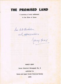
Book - ALEC H CHISHOLM COLLECTION: BOOK ''THE PROMISED LAND'' BY NANCY GRAY
Book. ALEC H CHISHOLM COLLECTION. 55 page softcover booklet on the history of the early settlement of the Upper Hunter and the Shire of Scone, NSW by Nancy Gray. Published in 1975 by the Scone and Upper Hunter Historical Society and printed by The Scone Advocate Ltd, Scone. Catalogue sticker ''2243 GRA'' on front cover. Handwritten in ink on title page ''For A H Chisholm with appreciation. Nancy Gray'' Also stuck inside front cover is a handwritten note by the author about the captions.Nancy Graybooks, collections, history, alec h chisholm collection, nancy gray, scone, upper hunter -
 Mt Dandenong & District Historical Society Inc.
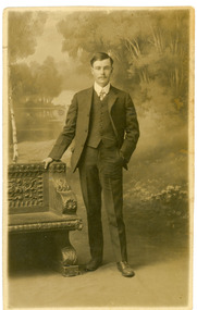
Photograph, Harry Booth, c1920s
Studio photograph of Harry Booth. A young man wearing a dark, three piece suit, collar and tie. Included in the Dorey/Woolrich collection.Black and white photograph of young Harry Booth taken in a formal studio setting. Harry Booth was the son of Jack Booth, who owned Lots 37 and 38 in the Village Settlement and had access to creek water for successful berry crops. Harry was a local market agent and travelled to Victoria Market carrying produce from local settlers.Harry carried a variety of produce by horse and cart, apparently a twenty-four hour round trip, until the business was sold in the early 1920's. Harry Booth Eden Studios Post Cardharry booth -
 Ballarat Tramway Museum
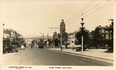
Photograph - Digital Image and Black & White Photograph/s, Valentine & Sons Publishing Co, 1938
Digital image provided by David Critchley of a postcard looking east along Sturt, north side towards Grenville St, at Doveton St. Has a detailed image of the tram. Tram has the destination of Lydiard St North. Note the decorations along the roadside for the centenary of settlement in the Ballarat district in 1938. Valentine Postcard No. 3273. .1 - large format print of the above image without the lower label. Has "Sturt St, Ballarat c1940's" along bottom edge. Print has "J75" in red ink in the top left hand corner on rear - the tram's Melbourne number.trams, tramways, sturt st, postcards, centenary, tram 14 -
 Bendigo Historical Society Inc.
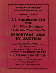
Document - IAN DYETT COLLECTION: AUCTION CATALOGUE - A1 CONSOLIDATED GOLD MINE
Three red covered auction catalogues for a sale on the 18th to 20th November, 1968 at the A.1. Consolidated Gold Mine A.1. Mine Settlement, 9 Miles from Woods Point, Vic. For sale was Most Valuable Electrical Mining Machinery, 20 Head Battery, Plant Equipment and Stores and Staff and Miners Homes - Mine Buildings Under Instruction from The Secretary for Mines. Also for sale was the Lease No. 8317 Beechworth. Catalogue has a Sketch Plan showing Mine Property.business, auctioneers, j h curnow & son pty ltd, ian dyett collection - auction catalogue - a1 consolidated gold mine, the secretary for mines, j h curnow & son pty ltd, f c dyett, l c osborne, clem hill, t apps, bolton's print -
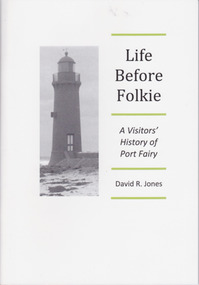 Warrnambool and District Historical Society Inc.
Booklet - Booklet about Port Fairy, Life before Folkie, 2013
This booklet aims to give a brief outline of Port Fairy’s history for the benefit of visitors. Port Fairy was an early sealing and whaling town with white settlement established by 1836. As the port and shipping declined so did the town until its reinvigoration in the mid 20th century as a tourist town and the home of the annual Port Fairy Folk FestivalThe book is of use as a quick reference to Port Fairy history.This is a booklet of 48 pages. It contains printed material, black and white photographs and a map. The front cover has a black and white image of the Port Fairy lighthouse. Front Cover: ‘Life Before Folkie, A Visitors’ History of Port Fairy, David R. Jones’port fairy, david r. jones -
 Warrnambool and District Historical Society Inc.
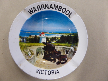
Ashtray, Mid 20th century
This is an ash tray sold to tourists as a souvenir of a visit to Warrnambool. It would have been relatively cheap to buy. Souvenirs such as this were mass-produced for the tourist market and a relevant photograph inserted on the base to suit the town or settlement where they were sold. As cigarette-smoking is no longer so socially acceptable, items such as this one are no longer sold as tourist souvenirs. This item is of interest as an example of the type of souvenir sold to tourists in Australia in the first half of the 20th century, probably in the 1940s or 1950s. It is of particular local interest because it contains a photograph of Warrnambool during that time. This is a souvenir tin ash tray circular in shape. It has a colour photograph of Warrnambool inserted into the base of the dish (Flagstaff Hill showing part of the fortifications, the Lower Lighthouse, a camping ground and Warrnambool Bay). The ash tray has three lips on the side of the dish for resting a cigarette. The base is gold-coloured and is slightly tarnished. ‘Warrnambool Victoria’ tourism in warrnambool -
 Wycheproof & District Historical Society Inc.
Wool Picture, Wycheproof Craft Group Emblem, 1984 (exact)
The Wycheproof Craft Group emblem made by Mrs Elaine Storey depicts a large ram and showcases beautifully, wool colours and versatility of creator and medium used. The wool industry, since Wycheproof's settlement days, has greatly supported the town, families and farming in general.The wool picture is the emblem of a local group that met between 1977 and 2010.This item is aesthetically significant as a visually pleasing craft piece that demonstrates the adaptability of skills to raw materials.It is representative of the lifeblood of the town of Wycheproof for 145 years.A framed wool picture constructed entirely from natural fleece, showing a merino ram in a paddock with natural looking vegetation growth. The subject aptly lends itself to a subtle display of various shades of wool colours. It is framed in oak wood.The word WYCHEPROOF is worked in fleece in an arc formation.Wycheproof Craft Group 1977-2010storey, wycheproof craft, wycheproof wool, spinners weavers, elaine -
 Lake Bolac & District Historical Society
Black and white photograph, "Narrapumelap", Wickliffe
"Narrapumelap" homestead, Wickliffe. The aboriginal meaning of Narrapumelap is a chain of waterholes. Begun in 1873 by John Dixon Wyselaskie and completed in 1878. The new owner in 1883 was Gerald Neville Buckley, son of Mr Mars Buckley, founder of Buckley and Nunn LTD, who 'enhanced' the building. The property was acquired for by the government in 1914 and later split up for Soldier Settlement.wickliffe, "narrapumelap, buckley, buckley and nunn, wyselaskie, soldier settlement -
 Lake Bolac & District Historical Society
Black and white photograph, Gunner Stanley Herbert Moreton, Field Artillery Brigade, WW1
Gunner Stanley Herbert Moreton, enlisted 04/12/1916 in a Field Artillery Unit. He embarked for France on 11/05/1917. Upon his return from the war, he purchased 'Parupa Park'. After WW2 Stanley was involved in helping with the subdivision of land for soldier settlement. He died in 1978 at the age of 85.moreton, field artillery unit, 'parupa park', soldier settlement, -
 Mt Dandenong & District Historical Society Inc.
Photograph, Harmony Vale Homestead
This photograph of 'Harmony Vale' homestead was taken by Daisy Rowse c1917. It is a copy of the original. 'Harmony Vale' was the home built c1860 by early settler Jabez Richardson and his wife Sarah Ann. Jabez Richardson arrived in 1855 with the Child and Jeeves families. The building and barn stood until 1933. The name Harmony Vale was given to the early settlement.Black and white photograph with the roof of a house in centre surrounded by trees. harmony vale, daisy rowse, jabez richardson, richardson, homestead -
 Warrnambool and District Historical Society Inc.
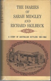
Book, The Diaries of Sarah Midgley and Richard Skilbeck, 1967
Pioneer diaries of early Australian settlers, Sarah Midgley and Richard Skilbeck.Tan hard covered book with tan and yellow dust jacket. Title and text is black. Front cover has framed drawing of cottage taken from photograph which is included in the book. Map of area is on inside front and back covers.208 pages. It has a number of black and white photographic plates included.non-fictionPioneer diaries of early Australian settlers, Sarah Midgley and Richard Skilbeck.sarah midgley, richard skilbeck, diaries of sarah midgley and richard skilbeck, yangery, early pioneer life, wesleyan church warrnambool, yangery koroit -
 St Arnaud and District Historical Society
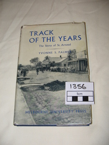
Book. Track of the Years, Track Of The Years. The Story of St.Arnaud.By Yvonne S Palmer
TRACK OF THE YEARS. The Story of St.Arnaud by Yvonne S Palmer had aroused local interest when this book was presented in 1955.The fortunes of this prosperous community, whose origins go back to the excitement of of the New Bendigo gold-rush, gleaned from an unusual wealth of reminiscences,diaries, letters, newspapers and photograph albums, are now placed permanently on record in this fascinating narrative. Contents: The New Bendigo Goldrush, Pastoral Settlement, The Aborigines of the Eastern Wimmera, A Permanent Goldrush, The Township Surveyed, Councils at Work 1861- 1870, Local Government in the District. 1861-1870. Sons of the Antipodes, Diggers in Townsmen, Daughters and Wives, Companies and Miners, Mining Settlements, Increasing Needs, Not by Bread Alone, The beginning of Farming, The Changing Countryside, A New St.Arnaud has Come, Deep Sinking and Dividends, Fewer farmers- Larger farms, Pride but not Complacency.Track of The Years by Yvonne S. Palmer. The Story of St.Arnaud. Hardcover book, blue cover with black and white photograph on the dustcover.Includes photographs and maps.308 pages, 1st Edition.1st Edition Published by Melbourne University Press in 1955. 308 pages. -
 Myrtleford and District Historical Society
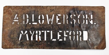
Tobacco bale stencil
Stencil used by Sgt. Albert David Lowerson, VC, a soldier settler on Merriang Estate near Myrtleford. Lowerson acquired one of 19 blocks assigned by the Closer Settlement Board on the 700 acre estate in 1920. The stencil marked bales of cured tobacco leaves prior to shipment to Melbourne. Lowerson was one of the few successful soldier settler farmers in the district, operating a piggery, dairy farming and growing tobacco for almost 20 years on "St. Quentin". (Lowerson was awarded the Victoria Cross at Mont St. Quentin on September 1, 1918.) His success and status enabled him to lead a submission on farm debt and infrastructure problems when the soldier settlement scheme was being reviewed at government level. He was active locally on these issues and supported fund raising for a war memorial, memorial hall and veteran welfare.The stencil represents the achievements of A.D.Lowerson, VC as an isolated example of success as a WW1 soldier settler and as a local identity who stridently supported the need for recognition and support of ex-service personnel.Stencil made of thin sheet metal, rusted .Wording of stencil "A.D.LOWERSON. MYRTLEFORD." lowerson a.d., merriang estate, myrtleford, closer settlement board, tobacco, st. quentin, victoria cross, world war 1 -
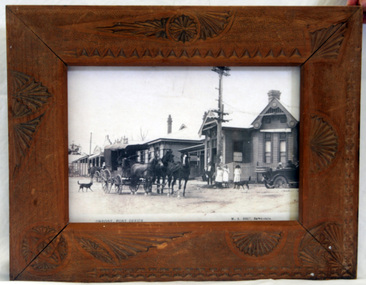 Orbost & District Historical Society
framed photograph, Vogt. W.S, 1917
This photograph was on display in the Orbost Information Centre - the Slab Hut - for many years. Originally the post office was not at Orbost at all but in the small settlement of Newmerella. The building in the photograph was completed and opened in 1898 at a cost of 1038/4/8 pounds. The post office building today is a replica of this building, opened in 2004 after a local campaign to retain a full post office in the town.The photograph of the early post office shows that it was a popular meeting place. Today's post office is a replica of this one and stands on the same site.A framed photograph of the Orbost Post Office (photocopy?) in 1917. The glass was cracked and has been removed. The frame is a wooden one with carved shell shape decorations. In the foreground of the photo is a horse and coach and an early model car. The mail coach is on its way to Cann River. In the car is the Warren family.W.S. Vogt, Bairnsdaleorbost post-office -
 Warrnambool and District Historical Society Inc.
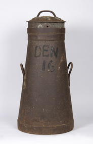
Container - Milk can, Early 20th century
This is a can used for storing milk at a dairy farm for transport to the local butter, milk or cheese factory. It comes from a farm (number 16) in Dennington, a settlement and now a suburb west of Warrnambool. It may have been supplying milk to the Nestles factory at Dennington by a truck or taken to a Nestles depot nearby. The Nestles factory was established in Dennington in 1907 and closed in 2005. This can is an interesting memento of dairying practices in the early to mid 20th century.This is a metal can with a circular base tapering to an open top. It has two handles on the side and a circular lid with a handle. It has a stencil on the side. The entire can is rusted.Den 16milk can, dairying in warrnambool district, nestles factory dennington -
 Warrnambool and District Historical Society Inc.
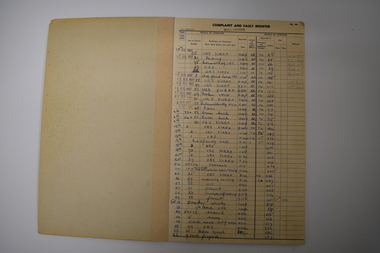
Ledger, Nullawarre Post Office, c.1960
This ledger came from the Nullawarre Post Office and was in use from 1967 to 1970. Nullawarre is a small settlement 25 kilometres south east of Warrnambool. European settlers first came to the Nullawarre district in the late 1860s and the area is largely agricultural. Charles and Vida Williams were the Post Master and Post Mistress at the Nullawarre Post Office in the mid 20th century.This ledger is of interest as it was used in the Nullawarre Post Office in the mid 20th century and is an example of business practices during that time. This is a ledger or booklet - a Complaint and Fault Register from the Nullawarre Post Office. It has a thick cardboard cover with green binding. The pages are ruled with black lines and black printed headings. The entries are handwritten in blue ink and pencil and some date stamps have been used. Most pages are blank. The corners of the ledger are slightly damaged. nullawarre post office, history of warrnambool -
 Glen Eira Historical Society
Article - Brunning, Leslie Herbert Ashby
An extract about Brunning’s Nurseries, St Kilda, taken from John Butler Cooper’s The History of St Kilda, from its first settlement to a city and after 1840 to 1930, Vol II. The extract is a short history of Brunning’s Nurseries, St Kilda. Includes a handwritten note by Deborah Towns citing the source, dated 08/07/2011.brunning george, brunning george edward, brunning herbert, brunning’s nurseries, g brunning and sons, st kilda, brunning street, brighton road, gardening, st kilda council, agricultural industry, commercial establishment -
 Hume City Civic Collection
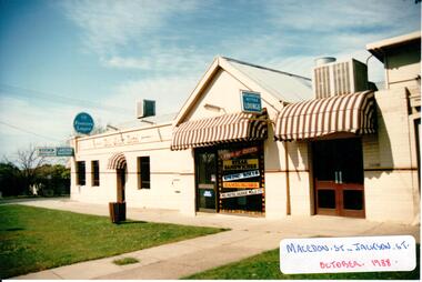
Photograph, 1/10/1988
The Ball Court Hotel was built in the late 1870's by John Cahill. It remained with the Cahill family until World War 2. The Lupson family were the hoteliers for 20 years after WW2 and in 1973 the McPhersons rebuilt the interior and added air conditioning to the building. The Ball Court Hotel is the only surviving hotel from Sunbury's early settlement.A coloured photograph of the side view along Macedon Street of the Ball Court Hotel showing the public bar in the original building, the Take-away area and the bistro. There are three windows and a door in the original building. The take-away section has a shop front facade and the bistro entrance has two double glass doors. All doorways are covered with a cantilever brown and white canvas awning. A footpath and grassed nature strip is outside the building. 3 blue and white brewery signs are along the side of the building and 2 air conditioning units are on the roof.In Gothic lettering 'BALL COURT HOTEL'hotels, cahill, john, mcpherson, mr and mrs, lupson, fred, ball court hotel, george evans collection -
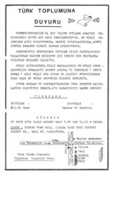 Moreland Turkish Association
Flyer, Turk Islam Cemiyeti, Turk Toplumu Duyuru, 1974
This flyer in Turkish was printed by the Turkish Islamic Society to advertise an event celebrating the 51st anniversary of the establishment of the Turkish republic. The program for the evening included patriotic songs, poems and traditional music and dance as well as a 3 act play entitled 'Yetis Kemal'. This type of event was regularly held by the Turkish Islamic Society in the early years of the settlement of the Turkish community in Melbourne. This flyer is of social significance and demonstrates a stage of settlement of Melbourne's Turkish community.One page flyer, printed on cream paper in black.migration, turkey, islam -
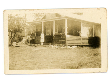 Mt Dandenong & District Historical Society Inc.
Photograph
Jim Keogh owned Lot 7 of the Village Settlement. When the new CRB road went through c1920 his block was cut through leaving a small triangle of land on the high side of the CRB road. He built a shop on this piece of land. The store burned down 31/12/1939. The woman on the step in this photo is Win Woodcock.Sepia image of a woman standing in front of a wooden store. Handwritten inscription on reverse by John Lundy-ClarkeJim Keogh's shop on the north west corner of Falls and Main Roads. Opposite diagonally from St Michael's Church of England. photo Nov 1926.jim keogh, keogh, store, shop, crb road, win woodcock -
 Ballarat Tramway Museum
Photograph - Black and White photograph/s - mounted, State Electricity Commission of Victoria (SECV), 1938
Photo of the Ballarat No. 23 decorated for the centenary of European settlement in the Ballarat district, 1838-1938. Has a label, black ink on white paper "Decorated Tram-car by Day - Ballarat Centenary", photographed at the depot. Photo held in position with plastic photo holders along the top edge only. Photo early 1938. On rear of item is Reg Item 3912.Yields information about the tram decorated for the Ballarat celebrations of the Centenary celebrations of European settlement in the Ballarat district, photographed at the depot. Original print of this photograph.Mounted photograph on black light weight card.In bottom left hand corner in ink "SEC photo"trams, tramways, secv, centenaries, illuminated trams, decorated trams, floral tram, tram 23 -
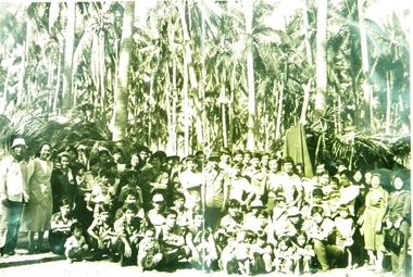 Archive of Vietnamese Boat People
Vietnamese boat people in Philippines, Refugees in Philippines, 1978
Vietnamese boat people landing in Philippines during the first years of the events (1975 - 1996). They were grouped up from many different islands and transferred to the refugee camp in Palawan Island. There they were interviewed and waited for decision from UNHCR to be granted settlement approval. Then they would be transferred to Bataan Processing Centre in Manilla waiting for flight to a third country.It is one of the very rare black and white photographs collected during the first years of the Vietnamese boat people in Philippines.Black and whilte picture taken at Lubang Island, Philippines, 1978. A group about 50 Vietnamese refugees landing in Lubang Island, Philippines, 1978. Pictures taken on a beach of the island, in front of 2 huts covered with coco-palm leaves as temporary shelter, together with two nuns and government workers coming to pick up and transfer to a refugee camp.Nguoi Viet ty nan tai Lubang, Philippines, 1978.lubang island, philippines, vietnamese refugees