Showing 681 items
matching auction sale
-
 Canterbury History Group
Map - Canterbury. Sale of the season, c1929
... Chatham Road Flere & Co Land Subdivision Auctions Photocopy ...Photocopy of sale notice for 28 mansion and villa sites in area bordered by Kent Avenue, Mont Albert Road, Faversham and Chatham Roads 29 September [1929]canterbury, mont albert road, faversham road, kent avenue, chatham road, flere & co, land subdivision, auctions -
 Bacchus Marsh & District Historical Society
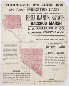
Map - Land Sales Plan, Broadlands Estate, Bacchus Marsh, 1916
This land sales map was produced by real estate agents for an auction of part of a property near Bacchus Marsh known as the Broadlands Estate. 132 acres of irrigated land in 11 separate lots was to be auctioned on the 8th of June 1916. On the 27 May 1916, nine of the 11 eleven lots were withdrawn from sale. The reason stated was due to "road and severance difficulties", according to a notice in the Bacchus Marsh Express newspaper on 27 May, 1916, page.2. When the sale took place on 8th June the two lots were passed in but the local newspaper reported they were expected to be sold privately, see Express, 17 June, 1916, page. 2. The Broadlands Estate was owned by the Miller family whose father Henry Miller, 1809-1888, was a politician and an immensely wealthy financier in Victoria.A typical example of a land sale map of this era. The Broadlands Estate was just over 2,000 acres at its its peak size and was a significant holding of land in the Bacchus Marsh district. Paper printed land sales mapbroadlands estate bacchus marsh, land sales bacchus marsh, farms bacchus marsh, henry miller 1809-1888 -
 Bacchus Marsh & District Historical Society
Map, Bacchus Marsh Township and Nearby Districts Maps Volume
This volume of maps is believed to have been compiled by staff at the Shire of Bacchus Marsh and was presumably used to inform and assist Shire staff and Councillors in the carriage of their duties.This collection of maps are significant due to their rarity as many of them are unique maps made for local purposes in the Bacchus Marsh region. They are also of strong research value containing a wide variety of information including landholders, land sales, infrastructure, such as roads, bridges, public, commercial and private buildings, houses, land use, and geographic features over multiple decades from the late nineteen century into the middle part of the twentieth century.One bound volume of maps comprising cadastral maps, (indicating property owners and land boundaries), land plans and real estate auction plans and advertising material, and other maps indicating major infrastructure like proposed roads and irrigation areas. Most of the maps and plans are of Bacchus Marsh and nearby areas but some maps are of nearby towns such as Melton, Ballan and Blackwood. The volume comprises 52 pages. Most pages have a single map or plan pasted onto it but some contain 2 or 3 different maps. There are 81 maps in total. Map 1 Liquidators Sale 1896. Map 2. Woodside Estate Sale 1913. maps, maps bacchus marsh, maps bacchus marsh region -
 Bacchus Marsh & District Historical Society
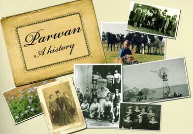
Book, Parwan: A History, 2010
Explores the history of the small farming community on the outskirts of Bacchus Marsh. It contains a plethora of fascinating details about the early years of this farming community from the 1830s until the early 2000s. There is a brief section at the beginning which looks at the history of the area prior to the colonial era. The book contains numerous sections about families and individual people who have lived in the Parwan area and includes many images of places and people. Citation: Parwan: A History by Dianne Van Leuvan. Published by Parwan History Group, Bacchus Marsh, Vic., 2010.Paperback printed book. 128 pages. with illustrations and photographs, some coloured. Includes facsimiles, maps, and index. Includes a separate folded sheet inside a pocket which has a reproduction of a map of the Parwan Parish in the County of Grant. On the reverse of this sheet are two reproductions. One is a land auction plan for February 1910 advertising the sale of portions of land from the Nerowie Estate. The other reproduction is a section of a map showing some of the blocks of land in the Nerowie Estate which has the heading, 'Nerowie Titles 1898'. A pocket inside the back cover contains a separate booklet which is an index, and two pages of 'Additional Information'.non-fictionExplores the history of the small farming community on the outskirts of Bacchus Marsh. It contains a plethora of fascinating details about the early years of this farming community from the 1830s until the early 2000s. There is a brief section at the beginning which looks at the history of the area prior to the colonial era. The book contains numerous sections about families and individual people who have lived in the Parwan area and includes many images of places and people. Citation: Parwan: A History by Dianne Van Leuvan. Published by Parwan History Group, Bacchus Marsh, Vic., 2010.parwan vic. history -
 Melton City Libraries
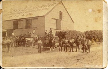
Photograph, 'Melton South Chaff Mill employees, Unknown
Charles E “Ernie” Barrie started constructing a Chaff mill on the corner of Brooklyn and Station road in 1900. It soon became a thriving business and was ideally located close to the railway line. Ernie and his father William and other Barrie brothers had been operated travelling chaff cutters in the district of Melton and Werribee. Within a short time the mill expanded into two big sheds in partnership with his brother James E known as “Ted”. The eldest brother William was in the Manager living in Melton South. In 1906 Ernie applied for a railway crossing on Brooklyn Road to have direct access for railway trucks to be shunted to the mill to be loaded. The Mill was also had the first phone to be connected, No 1, and No’s 2, 3 were the Golden Fleece and Macs Hotels. In 1906 Ernie married Jessie Lang daughter of the Head Teacher at Melton State School No 430 (1896 –1917). The Barrie house on the north side of the mill was completed in August 1906. It survived for almost 60 years until demolition. Chaff mills were very susceptible to fires and often burnt down and would be rebuilt again ready for the peak of the harvesting season. The final demise of the Mill occurred in a spectacular blaze on the night of Friday 2nd December 1977, just before the earth tremor as reported in the local paper. Brian Dobson the local photographer lived close by and captured the night blaze. A video was also taken of the action by the fire brigade. My parents Bon and Edna Barrie were living at 19 First Avenue, and took colour slides of the smouldering ruins in the half -light. Ironically Bon had spent the first year of his life (born in April 1909 and sister Mary born October 1907) at the house beside the mill. Trethowan’s Chaff mill in Brooklyn road was also destroyed by fire, which stated in the evening on Tuesday April 28th 1987. It was established in 1910 by Dixon Brothers, followed by, Ebbot & Kebby, Robinson, Trethowan and Butler and was with the Trethowan family when it burnt down. Melton South was small a community referred to as Melton Railway Station. Member of the community raised the idea to have a public hall. In 1909 Cr Barrie, Mr Nesbitt and Delany formed a committee to build a community hall. Cr Barrie donated the land and The Exford Hall was completed in September 1910 later to be named Victoria Hall. It was demolished in 1992. Colour slide in Barrie archive. In April 1910 the Ernie sold the Mill to Glover Onians (HSK Ward) family moved away to a property in Trundle NSW. Ernie had acquired 640 acres (a square mile) and leased a further 1920 acres of adjoining land. It was the practise of the farmers in the area at the time to buy up or lease the surrounding land from the 640 acre crown land blocks to make up acerage for a viable wheat farm. His wife Jessie found the climate to be very hot and when the Darlingsford property at Melton was put up for sale in the latter part of 1910 and was passed in at the auction. My grandfather saw this an opportunity to return to Melton. The negotiations to Darlingsford were finalised on May 11th 1911. Barrie bothers with connections to Chaff mills and farming in Melton from the 1900s William Henry, Charles Ernest, James Edwin, Samuel John, Robert, Arthur Roger, Albert Walter. Three grandsons and a great-grandson are in business earthmoving and farming in Melton today. (2013) Memoirs by Wendy BarrieEmployees at Chaff Mill, it was located on the corner of Brooklyn and Station Road, Melton South. local identities, agriculture -
 Wodonga & District Historical Society Inc
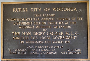
Plaque - Commemoration of the Opening of Liveweight Sales Wodonga Municipal Saleyards 1981
This plaque commemorates the official opening of the liveweight selling facilities at the Wodonga Municipal Saleyards, named the W. G. Page Saleyards, in 1980. Liveweight selling usually involves a curfew where cattle have to be at the saleyard by a specific time before the sale in order for them to be weighed prior to auction. Cattle that do not make the curfew time are sold on a $/head basis. The last sales at this facility took place in February 2015 before being replaced by the privately-run Barnawartha North's Northern Victoria Livestock Exchange. William George Page was Shire and City Engineer in Wodonga from 1965 until 1989. When he arrived the Shire of Wodonga had a population of 17,000 people. In 1966 Wodonga was selected as a city for special growth assistance. In 1972 Bill Page presented a new Town Plan to the Wodonga Council. Over the ensuing years he dedicated himself to bring this plan to fruition. He often had to argue and campaign with the Albury-Wodonga Corporation to push for the interests of development in Wodonga. This included winning a planning appeal to allow the saleyards to be relocated to Bandiana on the outskirts of Wodonga. Bill Page retired on health grounds in July 1989. The Council honoured him with a farewell dinner and renamed the saleyards at Bandiana the W.G. Page Saleyards in his honour.The Mayor , Cr Valentina Gillard, said "Every development in Wodonga in the past 24 years has a bit of Bill Page in it". William Page died 3 months later at 58 years old.A bronze forged metal plaque with detailed inscription. Bolts to fix plaque to the wall are still attached.RURAL CITY OF WODONGA / THIS PLAQUE/ COMMEMORATES THE OFFICIAL OPENING OF THE/ LIVEWEIGHT SELLING FACILITIES AT / THE WODONGA MUNICIPAL SALEYARDS /BY/THE HON. DIGBY CROZIER, M.L.C., / MINISTER FOR LOCAL GOVERNMENT/ ON WEDNESDAY, 4TH MARCH, 1981 CR. H. W, DRAPER, J.P. MAYOR R. I. O'TOOLE TOWN CLERK , CR. I. J. MACAULAY MARKETS CHAIRMAN W. G. PAGE CITY ENGINEERlivestock sales wodonga, liveweight cattle sales, municipal saleyards wondonga -
 Wodonga & District Historical Society Inc
Functional object - Seal - Police Office, Belvoir
This seal was used for official police and court documents by the Belvoir Police Office.The initial land survey for the city now known as Wodonga was first undertaken in 1852 by Thomas Wedge - Assistant Surveyor. The new township was called "Belvoir" and was proclaimed by that name in 1852 and again in 1861. The first sale of land in Belvoir was held at Wangaratta on April 28, 1854, when all the allotments surveyed by Thomas Wedge (excepting those set apart for reserves, government and public areas) were offered at auction. Following representations by the Postmaster General on June 23, 1869, the Governor in Council, on July 12, 1869, approved of its Aboriginal name "Wodonga" being restored. The seal was found at the Yackandandah Courthouse by the Circuit Judge, the late Mr. Jim Humphrey. As the Wodonga Historical Society was in recess at that time, the seal was held in trust by the North-East Historical Society in Wangaratta. It was donated to the Wodonga Historical Society in 1987.This item was the official seal of the Belvoir Police office from the beginning of the European settlement of the modern day city of Wodonga, then know as Belvoir. It is one of the earliest relics of that period of history, until its name was changed in 1869.Wood and metal seal bearing the official emblem of the Police Office Belvoir. It would have been used to apply a wax seal to official documents. The seal is mounted in a timber and glass case so that the imprint of the seal can be seen reflected in a mirror mounted in the base of the box.Around the edges of the seal "POLICE OFFICE / BELVOIR"belvoir police, official seal, history wodonga -
 Wodonga & District Historical Society Inc
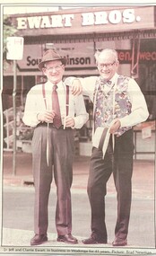
Photograph - Ewart Bros. Menswear 1954 - 1998
EWART BROTHERS MENSWEAR In 1954 Clarrie and Jeff Ewart opened their business, Ewart Bros. Menswear in High Street, Wodonga. They united after having worked in separate menswear businesses following schooling at St Augustine’s in Wodonga. Clarrie had worked at Abikhairs and Jeff had his own business after working at Cann’s in Albury. Over more than 40 years in business Ewart Bros. operated from different premises, first in a rented premises at 192 High Street, then their own shop at 180 High Street in 1965. Their second site became known as the 'long shop' as it extended from High Street and through to the Coles supermarket car park. In 1962 they also opened a book shop at 192A High Street, advertising sales of books, stationery, cards and school book orders. Ewart Bros. was put up for auction in November 1995, with Clarrie and Jeff intending to retire. However the business was passed in at auction, so the business continued. On Friday 3rd April 1998 a clearance sale of all shop fittings was finally held, with Ewart Bros Menswear thanking the customers and friends who had supported them over the past 45 years. Jeff died on 5th April 1999 and Clarrie died on 20 May 2020.These items are significant because they represent an important and long serving business in the Wodonga community.A collection of photos and advertisements for Ewart Bros. Menswear in Wodongaewart bros. menswear, wodonga businesses, jsff and clarrie ewart -
 City of Kingston
Pamphlet - Colour, W. H. Wood Estate Agent, Subdivisional Land Auction Barker's Estate Cheltenham, 1919
Sales plan for land in the suburb of Cheltenham, along Barker StreetThe developing urban area of Cheltenham within the City of Kingston. This land sale pamphlet illustrates the subdivision of land within the municipality and the changing demographic of the district as new houses are constructed.Colour pamphlet advertising subdivisional land auction of Barker's estate, on Barker Street Cheltenham.Handwritten in grey pencil on the subdivision map: a series of numbers on each block possibly indicating the sale price. Handwritten in grey pencil on the subdivision map: Roy- joined to subdivision 6 Handwritten in grey pencil on the subdivision map: x on the border between subdivision 17 and 16, and again on the border between subdivision 12 and 11.cheltenham, land sales, estate -
 City of Kingston
Pamphlet - Colour, H. R. Hill & Co, Walker's Estate, Cheltenham for sale by public auction, c. 1923
... Walker's Estate, Cheltenham for sale by public auction..., Cheltenham for sale by public auction Pamphlet Colour H. R. Hill & Co. ...Sales plan for land in the suburb of Cheltenham, encompassing both sides of Walker Grove, a section of Centre Dandenong Rd and Axelton St. The developing urban area of Cheltenham within the City of Kingston. This land sale pamphlet illustrates the subdivision of land within the municipality and the changing demographic of the district as new houses are constructed.Black and white pamphlet advertising for private sale the Station Entrance Estate, Highett. Incorporates a map of the estate bordered by Wickham Road, Railway Parade, Highett Road and Point Nepean Road.Handwritten in black pen on subdivision map: 'x' written on subdivisions 2, 3, 8-11, 15-17, 19. Potentially indicating that these properties did not sell at auction. Handwritten in black pen on subdivision map: assumed sale price on subdivisions 1, 4-7, 12-14, 18, 20-31. land sales, cheltenham, estate -
 City of Kingston
Pamphlet - Colour, Stillwell and Co, Cheltenham Charman Estate Realising Auction, 1921
Sales plan for land in the suburb of Cheltenham, along Charman Road and Weatherall Street.The developing urban area of Cheltenham within the City of Kingston. This land sale pamphlet illustrates the subdivision of land within the municipality and the changing demographic of the district as new houses are constructed.Colour pamphlet advertising realising auction of the Charman Estate, Cheltenham. Incorporates a map of the estate, showing subdivisions along Charman Road and Weatherall Street.land sales, cheltenham, estate -
 City of Kingston
Pamphlet - Colour, Roy Dunn Pty. Ltd, Subdivisional auction of Highett Station Estate, c.1924
Sales plan for land in the suburb of Highett, bounded by Worthing Road, and the Melbourne to Frankston Electric Railway Line, including LePage Street. The developing urban area of Highett within the City of Kingston. This land sale pamphlet illustrates the subdivision of land within the municipality and the changing demographic of the district as new houses are constructed close to infrastructure.Colour pamphlet advertising a subdivisional auction of the Highett Station Estate. Incorporates a map of the estate bordered by Worthing Road and the Melbourne to Frankston Electric Railway, and including LePage Street. Handwritten in black ink on front cover: Late LePage / Wickham Rdland sales, estate, highett -
 Melbourne Legacy
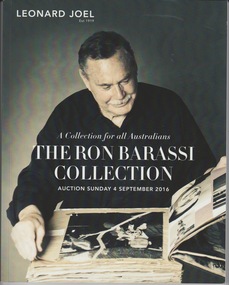
Book, The Ron Barassi Collection Auction Catalogue, 2016
An auction catalogue of items being sold by AFL personality Ron Barassi in 2016. It appears to be a signed copy. The second last page is a note of thanks to Legacy for the help they gave Ron as a boy and mentions he made Legacy his lifelong charity. A note that accompanied the catalogue mentions Ron Barassi donated a significant amount of the sale proceeds to Legacy. Ron Barassi was helped by Legacy as a boy after his father, Ronald Barassi Snr died at Tobruk in 1941. Ron Barassi Snr was also a football player for Melbourne Football club. The catalogue on page 8 mentions that when his mother remarried and moved to Tasmania, Ron stayed in Melbourne with Norm Smith and family to further his football career. This is unlikely to be Legatee Norm Smith. Ron Barassi helped promote Legacy in many ways and at many events over many years.A record of important personalities such as Ron Barassi chose to donate to Legacy.Colour 104 page auction catalogue of items belonging to Ron Barassi.ron barassi, donations -
 Federation University Art Collection
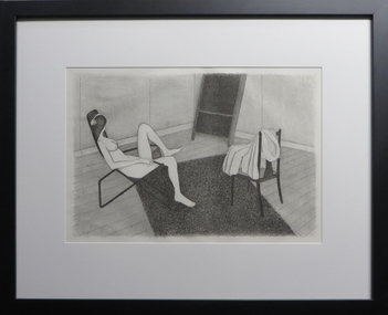
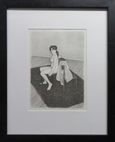
Work on paper - Artwork - Printmaking, John Brack, 'Nude 3' (Also known as Nude in a Chair) by John Brack, 1982
John Brack (1920-1999) Born AustraliaFramed, limited edition lithograph. Originally produced to be bound in a book by private press publisher Tate Adams. The suite of lithographs for the book was started by John Brack in September 1981 and finished and published in December 1982. The book was launched with a series of original conte drawings, from which the lithographs were based, in Realities Galleries, Melbourne. As such a high cost of production was involved in the binding of the book, only fifteen copies were originally bound for exhibition and sale at the show. Subsequent to this approximately another thirty copies were bound, making a total finished edition of fewer than fifty copies, far less than the anticipated 200. A number of the 50 hors commerce editions have been sold as individual plates through auctions and galleries. A number of sheets were recently discovered through the estate of Brack’s art dealer Rudy Komon (1908-1982). This unsigned work is from Rudy Koman's estate.john brack, nude, life drawing, available, chair -
 Federation University Art Collection
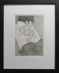
Work on paper - Artwork - Printmaking, (Nude seated facing left with robe on second chair, on shag rug), by John Brack, c1982
Framed, limited edition lithograph. Originally produced to be bound in a book by private press publisher Tate Adams. The suite of lithographs for the book was started by John Brack in September 1981 and finished and published in December 1982. The book was launched with a series of original conte drawings, from which the lithographs were based, in Realities Galleries, Melbourne. As such a high cost of production was involved in the binding of the book, only fifteen copies were originally bound for exhibition and sale at the show. Subsequent to this approximately another thirty copies were bound, making a total finished edition of fewer than fifty copies, far less than the anticipated 200. A number of the 50 hors commerce editions have been sold as individual plates through auctions and galleries. A number of sheets were recently discovered through the estate of Brack’s art dealer Rudy Komon (1908-1982). This unsigned work is from Rudy Koman's estate.john brack, printmaking, available -
 Federation University Art Collection
Work on paper - Artwork, Nude 3 (Nude on Sofa and Persian rugs reclining away from viewer) by John Brack, c1982
Framed, limited edition lithograph. Originally produced to be bound in a book by private press publisher Tate Adams. The suite of lithographs for the book was started by John Brack in September 1981 and finished and published in December 1982. The book was launched with a series of original conte drawings, from which the lithographs were based, in Realities Galleries, Melbourne. As such a high cost of production was involved in the binding of the book, only fifteen copies were originally bound for exhibition and sale at the show. Subsequent to this approximately another thirty copies were bound, making a total finished edition of fewer than fifty copies, far less than the anticipated 200. A number of the 50 hors commerce editions have been sold as individual plates through auctions and galleries. A number of sheets were recently discovered through the estate of Brack’s art dealer Rudy Komon (1908-1982). This unsigned work is from Rudy Koman's estate.john brack, printmaking, nude -
 Ringwood and District Historical Society
Document - Land Sale Folder, Auburn Grove Estate Ringwood East - 2011-2013
Folder containing flyers and multi-fold colour pamphlet advertising Auburn Grove Estate with maps and layout of subdivision and photographs of area. Flyers for First Release Auction 6 August, 2011 enclosed, and Second and Final Release Private Sale flyer with copy showing handwritten sale prices.Estate plan includes Auburn Grove off Longview Road and adjoining Tintern Grammar School, Ringwood East, Vic. Agents - Carter Real Estate, 90 Maroondah Highway, Ringwood Vic 3134. Phone 9870 6211 Fax 9870 6024. Accompanying folder includes handwritten auctioneer's notation (Richard Carter) on the name, that Auburn Grove Estate is adjacent to Tintern Farm - Tintern School originally having moved to Ringwood East from Auburn, Melbourne (1953). -
 Ringwood and District Historical Society
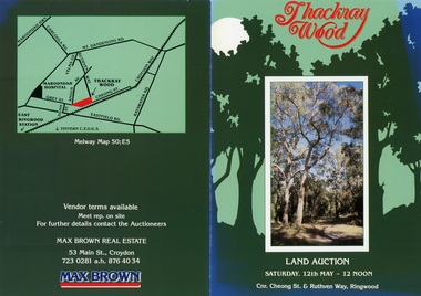
Flyer, Land Auction Brochure - Thackray Wood, Ringwood East - circa 1984
... of additional copy with handwritten sale prices. Land Auction Brochure ...Double sided bi-fold sales brochure regarding sale of 14 blocks of land comprising Thackray Wood, corner Cheong Street and Ruthven Way, Ringwood East. Agent: Max Brown Real Estate, 53 Main Street Croydon, Tel 7230281 a.h. 8764034. Inset image of additional copy with handwritten sale prices. -
 Bendigo Historical Society Inc.
Flyer - Lancewood House Bendigo Auction
Mixed photocopies of parts of the Auction booklets and details of the furnishings from Lancewood House, McLaren Street, Bendigo (from the famed Meuller residence). Auction held over several days in June 1949. furnishings of a victorian house, sale june 1949 -
 Bacchus Marsh & District Historical Society
Map, Bacchus Marsh Suburban Allotments Parwan Road Lodge & Dunn's Paddocks 1888
This map was created as a plan for an auction of land close to the Bacchus Marsh Railway Station. The auction took place on 23 October 1888. 102 allotments of land from an area known as Lodge and Dunn's paddocks was offered for sale. A single page paper map showing allotments of land for sale along the Parwan Road in Maddingley. The map is pasted into a bound volume containing 76 maps or plans in total. High resolution digital image stored on BMDHS computer network. land sales bacchus marsh, land sales maddingley, bacchus marsh victoria maps, maddingley victoria maps -
 Bacchus Marsh & District Historical Society
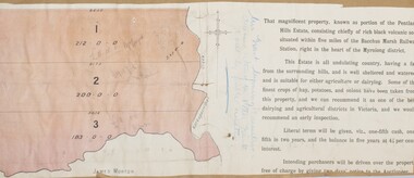
Map, Pentland Hills Estate Land Sale 1904
The Pentland Hills Estate property shown in this auction plan was put up for sale in 1904. It was a deceased estate sale. The property had been owned by Peter Grant who died in 1899. Peter Grant had worked and farmed in the Myrniong area for many years and had also been a Councillor on the Bacchus Marsh Shire for a number of terms. A property sales report in the Express newspaper recorded that the land for sale comprised 500 acres of the old Pentland Hills Estate. It was subdivided into three lots, all of which were sold at good prices. Lot l, 212 acres was sold to Messrs Thomas and Robert Lidgett of Myrniong, at £11/15/ per acre, lot 2, 200 acres, to Mr David Robertson, of Bacchus Marsh, at £9 17/0 per acre, and lot 3, 38 acres, was sold to Mr James Norton, jun at £11 per acre. A single page paper map showing a portions of land available for sale from the Pentland Hills Estate near Bacchus Marsh.The name of the seller, Mrs Grant, can seen handwritten on this map and the buyers of the three portions for sale, Lidgett lot 1, Robertson lot 2 and Morton lot 3. Parts of the text are missing along the edges due to tearing or excessive trimming of the edges. The map is pasted into a bound volume containing 76 maps or plans in total. High resolution digital image stored on BMDHS computer network. Handwritten: Mrs Grant, Myrniong, Executrix in the deceased Estate of Mr. Peter Grant to sell by public auction.land sales, pentland hills maps, myrniong area land sales, pentland hills estate -
 Churchill Island Heritage Precinct
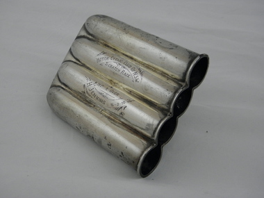
Functional object - Trophy, 1902 hallmark C
... Evans, a family friend, on the day of the auction sale ...The Churchill Island collection includes an number of historic objects from the late 1800s. The collection is presented in sets and series, of which this trophy represents the Jenkins era.This trophy demonstrates Harry Jenkins' prowess of motor sport and his competitive spirit, was awarded for a motorcycle race held in NSW on 16/02/1910. This item was given to Arthur Evans, a family friend, on the day of the auction sale of artifacts in 1973. This is one of very few orginal items found within the Churchill Island museum collection.Large solid metal three-dimensional object featuring 4 identical cylinders open at one end. All 4 cylinders are joined, domed in profile and designed to represent the four cylinders of a motor bike. The object is engraved and has silver plated hallmarks. MOTOR CYCLE CLUB OF NSW / SCRATCH RACE / 4 HP AND OVER / H JENKINS 16-2-10 SYDENHAM PATENT 2272 / A S trophy, harry jenkins, motor bike racing, churchill island, 16/02/1910, scratch race, 4 hp and over, motor cycle club of nsw -
 Ringwood and District Historical Society
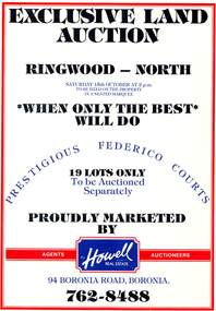
Pamphlet, Land Auction Brochure - Federico Courts Estate, Ringwood North, Vic. Circa 1988
Bifold brochure advertising auction of 19 residential allotments on Saturday 15th October, (1988?). Brochure includes terms of sale, description of subdivision features and local facilities, with locality map. Subdivision includes Federico Court and Gilston Way, Ringwood North. Agents/Auctioneers - B.S. Howell Real Estate, 94 Boronia Road, Boronia, (Phone) 762 8488. -
 Bendigo Historical Society Inc.
Document - LANDS OFFICE: SALE OF CROWN LANDS BY PUBLIC AUCTION, 25/5/1898 - 26/8/1915
Journal: green hard cover journal with brown spine and corners. LH page: lot, county, town or parish, section, allotment, extent, why not sold, upset price per acre, sold for per acre. RH page: value of improvements, name of purchaser, residence, deposit forfeited, total amount. Contains details of sales by public auction across Victoria.Lands Officecrown lands public auction, lands office, crown lands, public auction., sandhurst -
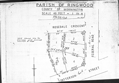 Ringwood and District Historical Society
Document - Folder, Map of Subdivision for auction - Ringwood East, Vic., 1973
Photocopy of Parish Map showing five residential blocks for sale on Rosedale Crescent, Federal Road and Patterson Street Ringwood East.Accompanying handwritten sales notes researched in 2024 by Richard Carter - Carter Real Estate - "5 lots (heavily filled) auction 14 July 1973. All later sold $4000 each - unknown agent". -
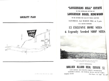 Ringwood and District Historical Society
Document - Folder, Subdivision Auction - Loughnans Hill Estate 1962, Ringwood, Victoria
Double-sided bifold page advertising auction on Saturday 3rd March, 1962 - 13 residential allotments in Hearthside Court and 6 shop sites in Loughnan Road, with map of subdivision, terms of sale, and summary of features and services. Adjoining service station shown on accompanying Plan of Subdivision - Part of Crown Allotment 28 Parish of Warrandyte, also showing location of property known as "Hearth", hence Hearthside Court.Auctioneers - Baillieu Allard Real Estate Pty Ltd., 360 Collins Street, Melbourne, and 302 Toorak Road, South Yarra. Telephone 24-4365, After hours XU1549, WL2471. -
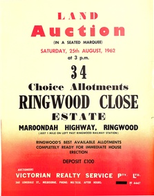 Ringwood and District Historical Society
Pamphlet, Land Auction Brochure - Ringwood Close Estate, Ringwood, Victoria - 1962
Brochure advertising public auction of 34 allotments on Saturday 25th August, 1962. Brochure includes terms of sale, description of subdivision features and local facilities, with locality map. Subdivision includes Anthony Court, Nina Court and Wingrove Place, off Maroondah Highway, Ringwood.Auctioneer - Lindsay Lord, Victorian Realty Service Pty Ltd., 360 Lonsdale Street, Melbourne. Phone MU7858, After hours XF4447. Map includes handwritten pricing notations for some allotments. -
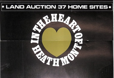 Ringwood and District Historical Society
Pamphlet, Land Auction Brochure - Heathmont Hills Estate, Heathmont, Vic
Multi-fold brochure advertising auction of 37 home sites on Saturday May 6th, (1967?). Brochure includes terms of sale, description of subdivision features and local facilities, with locality map. Subdivision includes Canterbury Road, Cuthbert Street, and Craig Court, off Balfour Avenue, Heathmont. Agent - N.R. Reid & Co Pty Ltd., 173 Coleman Parade, Glen Waverley, (phone) 560 0355 A.H. 28 3185, in conjunction with H.G. McLean Pty Ltd., 166 Canterbury Road, Heathmont, 87 7808 A.H. 842 2708. -
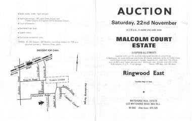 Ringwood and District Historical Society
Flyer, Land Auction Brochure, Malcolm Court Estate, Ringwood East, Vic. - 1969
Bi-folded single sheet with black print both sides advertising Auction on Saturday, 22nd November, 1969. Details include location map, vendor terms, subdivision features and local facilities. Centre page shows allotment numbers and property dimensions. Agent - Whitehorse Real Estate, 1123 Whitehorse Road, Box Hill, (Phone) 890502, After hours 8781429. Separate copy of map with handwritten sale notations for some allotments.LP 859686 -
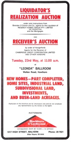 Ringwood and District Historical Society
Pamphlet, Liquidator's and Receiver's Auction, Highland Boulevard, Ringwood, Victoria, and other locations - Circa 1980
Multi-fold brochure with Order of Sale list of home sites, industrial land, subdivisional land and bushland acreages being auctioned at "Leonda" Ballroom, Hawthorn, Vic., Tuesday 23rd May (year not documented, circa 1980). Brochure includes 8 homesites with handwritten sales notations for Lots 94, 99, 100, 102, 104 and 105 Highland Boulevard, Ringwood at 11.30a.m., and at 11.45a.m., 3 completed homes at Lots 86, 88 and 89 & 5 near-completed homes Lots 74, 75, 76, 77 and 79 Highland Boulevard. Auctioneers - Blackburn & Lockwood Pty Ltd., 1017 High Street, Malvern, Phone 207821 After Hours 20 4444.Liquidator's Realization Auction under joint instructions from Brendan O'Connor and Co., agents for the Liquidator of Regency Homes Group Pty. Limited (in Liquidation) and the Mortgagee. Receiver's Auction by order of Hungerfords, Agents for the Receiver of Cambridge Credit Corporation Limited and other vendors. Order of Sale property locations include Mulgrave, Ringwood, Doncaster, Portartlington, Geelong, Altona, Mooroolbark, Scoresby, Gembrook, Maidstone, Port Melbourne, Laverton, Werribee, Werribee North, and Sunshine.