Showing 1161 items
matching dairy
-
 Kew Historical Society Inc
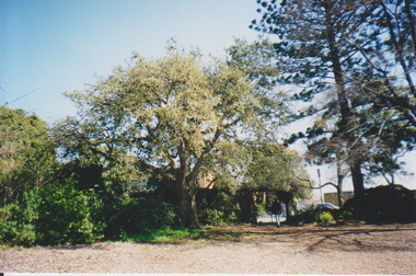
Photograph - Flooding of the Yarra River in North Kew, 1934
North Kew, now divided between Kew and Kew East, bordered the Yarra River. As such, it was a region subject to flooding in the Yarra Valley. Development beyond this point (ie Kellett Grove) was limited by the City of Kew's planning regulations. Prior to urban development, the area since European settlement and the first land sales in the district in the 1840s, had been used for dairy farming. Small sepia snapshot of floodwaters in North Kew, from the rear of 8 Kellett Grove. Verso: OUR BACKYARD / Stamped 52yarra river -- north kew, floods -- yarra valley, floods -- north kew, floods -- 1934, natural disasters -- kew, willsmere road -
 Kew Historical Society Inc
Photograph - Grandfather and granddaughter in the yard of 8 Kellett Grove, Kew, 1934
North Kew, now divided between Kew and Kew East, bordered the Yarra River. As such, it was a region subject to flooding in the Yarra Valley. Development beyond this point (ie Kellett Grove) was limited by the City of Kew's planning regulations. Prior to urban development, the area since European settlement and the first land sales in the district in the 1840s, had been used for dairy farming. Vivid photograph contrasting domestic life and relationships with natural disasters such as the flood of 1934.Small sepia snapshot of a grandfather and granddaughter sitting in the backyard of 8 Kellett Grove, North Kew, with the floodwaters stretching behind them.Verso: GRANDDAD AND I IN BACKYARDyarra river -- north kew, floods -- yarra valley, floods -- north kew, floods -- 1934, natural disasters -- kew, willsmere road -
 Kew Historical Society Inc
Photograph - Submerged houses in River Avenue, North Kew, 1934
North Kew, now divided between Kew and Kew East, bordered the Yarra River. As such, it was a region subject to flooding in the Yarra Valley. Development beyond this point (ie Kellett Grove) was limited by the City of Kew's planning regulations. Prior to urban development, the area since European settlement and the first land sales in the district in the 1840s, had been used for dairy farming. Vivid photograph contrasting domestic life and relationships with natural disasters such as the flood of 1934.Small sepia snapshot of two submerged houses belonging to local families in River Avenue, North Kew, during the 1934 floods. The view is presumably from near Kellett Grove looking north towards Fairfield.Verso: COES & HYATTS ROOF / RIVER AVENUE / Stamped: 6414yarra river -- north kew, floods -- yarra valley, floods -- north kew, floods -- 1934, natural disasters -- kew -
 Kew Historical Society Inc
Photograph - Flooding of the Yarra River in North Kew, 1934
North Kew, now divided between Kew and Kew East, bordered the Yarra River. As such, it was a region subject to flooding in the Yarra Valley. Development beyond this point (ie Kellett Grove) was limited by the City of Kew's planning regulations. Prior to urban development, the area since European settlement and the first land sales in the district in the 1840s, had been used for dairy farming. Vivid photograph contrasting domestic life and relationships with natural disasters such as the flood of 1934.Small sepia snapshot of the donors grandfather rescuing the family dog's kennel from rising floodwaters at the rear of 8 Kellett Grove, North Kew, .Verso: DAD SECURING NIPPY'S DOG KENNEL / Stamped 6414yarra river -- north kew, floods -- yarra valley, floods -- north kew, floods -- 1934, natural disasters -- kew -
 Kew Historical Society Inc
Photograph - Flooding of the Yarra River in North Kew, 1934
North Kew, now divided between Kew and Kew East, bordered the Yarra River. As such, it was a region subject to flooding in the Yarra Valley. Development beyond this point (ie Kellett Grove) was limited by the City of Kew's planning regulations. Prior to urban development, the area since European settlement and the first land sales in the district in the 1840s, had been used for dairy farming. .Small sepia snapshot of a local family's house in what was then River Avenue, North Kew being surrounded by floodwaters.Verso: THE SIDE OF RYANSyarra river -- north kew, floods -- yarra valley, floods -- north kew, floods -- 1934, natural disasters -- kew -
 Kew Historical Society Inc
Photograph - Flooding of the Yarra River in North Kew, 1934
North Kew, now divided between Kew and Kew East, bordered the Yarra River. As such, it was a region subject to flooding in the Yarra Valley. Development beyond this point (ie Kellett Grove) was limited by the City of Kew's planning regulations. Prior to urban development, the area since European settlement and the first land sales in the district in the 1840s, had been used for dairy farming. .Small sepia snapshot of what was then River Avenue, North Kew submerged by floodwaters.The photo was taken in the vicinity of 8 Kellett Grove, North Kew. Verso: TAKEN FROM OUR STREET JUST SEE A BIT OF RYAN'S FENCE / 1934yarra river -- north kew, floods -- yarra valley, floods -- north kew, floods -- 1934, natural disasters -- kew -
 Kew Historical Society Inc
Photograph - Flooding of the Yarra River in North Kew, 1934
North Kew, now divided between Kew and Kew East, bordered the Yarra River. As such, it was a region subject to flooding in the Yarra Valley. Development beyond this point (ie Kellett Grove) was limited by the City of Kew's planning regulations. Prior to urban development, the area since European settlement and the first land sales in the district in the 1840s, had been used for dairy farming. .Small sepia snapshot of the devastation caused by the 1934 flood.The photo was taken in the vicinity of Kellett Grove, North Kew and includes the roof of Chipperfield's Boathouse as well as other local houses.Verso: THIS IS CHIPPERFIELD'S BOAT SHEDS & COES & WILLIAMS TAKEN FROM OUR STREET / 1934yarra river -- north kew, floods -- yarra valley, floods -- north kew, floods -- 1934, natural disasters -- kew, chipperfields boathouse -
 University of Melbourne, Burnley Campus Archives
Functional object - Horseshoe, Draught horse shoe (used)
Horseshoe from one of the Burnley College draughthorses enclosed in postage envelope. Probably souvenired by a student who returned it back to the Archives 14 May 1991 - which were in the Dairy/Bookshop. Sent back in mail enclosed in University of New England, Armidale NSW envelope addressed to the Horticulture shop, Burnley Gardens Swan Street Richmond Vic 3121, Postage paid.Horseshoe from one of the draughthorses. horseshoe, burnley -
 Kiewa Valley Historical Society
Manila Folder - Newspaper cuttings and photos - Ryder Family, Ada & Walter Ryder Family
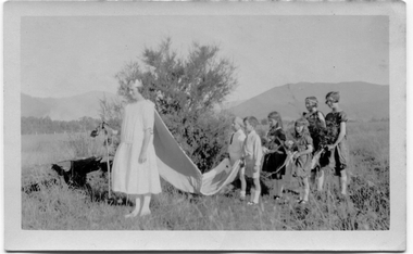
The Ryder family have lived and farmed in the Kiewa Valley since the 1840sMemorabilia of the Ryder family in the Kiewa Valley is an example of changing activities and interests etc in the Kiewa Valley since the 1840s through to the current day.1. Merit Certificate for Dorothy Ryder 1938 2. Three newspaper cuttings a) Hospital Town Highlight b) Time Moves On c) Joan Lang - the woman who could...and did! 3. Three slides a) Dairy Farm on banks of Kiewa River b) Mt Beauty c) Rocky Valley Dam 4. Four photos a) Beatrice Ryder on Empire Day b) Ada with son Walter Ryder c) Beatrice & Vera Ryder d)Skiers on High Plainsb) and c) photos labelled on the backryder family, kiewa valley farming -
 University of Melbourne, Burnley Campus Archives
Photograph - Plan of Burnley Gardens
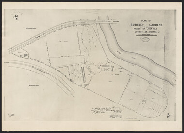
"This plan is a copy of a copy of the survey made by Mr. Turner in 1926. The original plan and field notes are missing _ file Rs 3529" Signed by _signature unreadable_ -
 University of Melbourne, Burnley Campus Archives
Photograph - Sepia print, Jersey Cows, Unknown
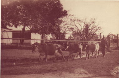
Note associated with this photograph, "Removed from Record Book (B91.453) labelled, 'Stock Breeding Record,' Purple and Black [cows.]" Note by T.H. Kneen 8 April 1992, "Jersey cows moving from pastures at west end of property past the Egg-Laying Competition pens, heading for the milking shed."Sepia photograph. 3 jersey cows walking beside a fence with egg laying pens behind. Man walking behind them.stock breeding record, cows, jersey cows, egg-laying competition, dairy, lagoon paddock, milking shed, poultry pens, stockman -
 Kiewa Valley Historical Society
Milk Cartons - 2 litre & 1 litre, 2 litres - 1986. 1 litre - 1980's
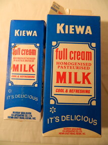
The North-Eastern Dairy Company was established on 14th December 1892 as a butter factory and built in 1893. In 1928 a new butter factory was built and a milk products factory in 1952. Whole milk sales commenced in 1951, with pasteurised, homogenised milk in both bottles and cartons being sold in the 1980's. Devondale / Murray Goulburn was established in 1950. Cartons enabled the safe transportation and storage of milk. The North East Dairy Company enabled the dairy farmers in the Kiewa Valley to send their milk and milk products eg. cream to the factory at Kiewa. The factory bought its own cream carting vehicles during WW1. The 'full cream / homogenised / pastuerised / milk' is an example of the milk available in the 1980's as many different varieties of ingredients followed in later years.Blue, red & white waterproof sealed cardboard box used for storing fresh milk from the Kiewa factory 'Murray Goulburn'. The large box contains 2 litres and the smaller box, 1 litre. Each of the 4 faces have print - 2 have the title, 1 has advertising and 1 has instructions on how to store the carton of milk2 litre - Use by Date stamped at the top: 'Un Ed Oct 19' 1 litre - Use by Date stamped at the top: 'Ned Feb. 13'milk, murray goulburn, kiewa butter factory, kiewa milk products -
 Greensborough Historical Society
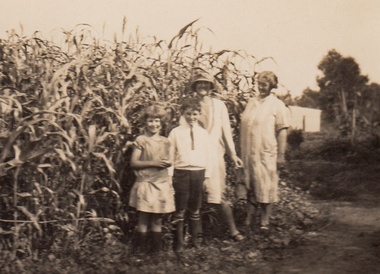
Photograph - Digital Image, Cherel Sartori, Claude Amiet at Kell's Cottage 1920s, 1920c
Photograph of Claude Amiet and others at Kell's Cottage in the 1920s. The house was built 1917, at 112 Henry Street Greensborough by William Mitchell on the 60 acre dairy farm owned by Ethel and Walter Kell. This collection of photographs was copied by Cherel Sartori (who owned the house from 1990-2000), following a visit by Claude Amiet who lived in the house as a child in the early 20th century.Digital copy of black and white photographkell's cottage, claude amiet, cherel sartori -
 Greensborough Historical Society
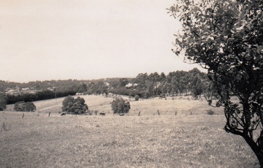
Photograph - Digital Image, Cherel Sartori, Looking east from Henry Street to the river 1956, 01/01/1956
Looking from Henry Street east to the Plenty River, 1956. The house was built 1917, at 112 Henry Street Greensborough by William Mitchell on the 60 acre dairy farm owned by Ethel and Walter Kell. This collection of photographs was copied by Cherel Sartori (who owned the house from 1990-2000), following a visit by Claude Amiet who lived in the house as a child in the early 20th century.An indication of the rural aspect of this area in the mid-20th century.Digital copy of black and white photographkell's cottage, claude amiet, cherel sartori -
City of Moorabbin Historical Society (Operating the Box Cottage Museum)
Tools, Nail remover snip c 1900, c1900
These forged nail snips we used to remove embedded nails by builders. Among the early settlers in Moorabbin Shire were blacksmiths who made tools for the other settlers who were establishing the homes, market gardens, farms, orchards and various businesses. Early settlers were self reliant and repaired their own equipment for kitchen,dairy, farm, horses, carts using various tools . This hammer is typical of the type used by early settlers in Moorabbin Shire c1900This forged steel nail snip was used to remove embedded nails by builders c1900forged nail snips, early settlers, market gardeners, blacksmiths, tools, building equipment, hammers, moorabbin shire, bentleigh, mckinnon, highett, cheltenham,mcewan james pty ltd, melbourne, bunnings pty ltd, -
City of Moorabbin Historical Society (Operating the Box Cottage Museum)
Tool - Tools, Saw double sided pruning 20thC, 20thC
Among the early settlers in Moorabbin Shire were blacksmiths who made tools for the other settlers who were establishing the homes, market gardens, farms, orchards and various businesses. Early settlers were self reliant and repaired their own equipment for kitchen,dairy, farm, horses, carts using various tools . This is a double sided pruning saw with tapering blade used by orchardists and farmers This pruning saw is typical of the type used by early settlers in Moorabbin Shire c1900A steel saw with double sided tapering blade and wood handle for pruning trees. saws, pruning saws, orchardists, fower gardens, fruit trees, early settlers, market gardeners, blacksmiths, tools, building equipment, hammers, moorabbin shire, bentleigh, mckinnon, highett, cheltenham,mcewan james pty ltd, melbourne, bunnings pty ltd, -
 Melbourne Tram Museum
Photograph - Digital Image, Kevin O'Reilly, "Kew Burke Rd' looking at the East Kew Tram terminus, c1925
Image from CD (Compact Diskette for use in computers) - see Reg Item 135. Image titled "Kew Burke Rd' on CD, of looking at the East Kew Tram terminus with the city skyline in the background, c1925. Photo published in the Bellcord No. 16, Oct. 2012. From the article with the photograph; The terminus was located at the intersection of High St, Burke, Kilby and Doncaster Roads. We are at the outer edges of Melbourne’s suburbia at the time, unlike the current tram terminus of today. Burke Road, north of Doncaster Road is clearly under construction in preparation for the new river crossing. The vacant block of land in the foreground will remain so for another ten years or so. In 1960 the new Dickens Supermarket was built on this site and the intersection became known locally as Dickens Corner. The narrow track on the left hand side of the photo is Doncaster Road. The tram at the terminus is a straight-sill single trucker of one of the G, K, Q or R classes. It is finished in the late MMTB chocolate and cream livery. A cable grip car body has been placed as a tram shelter at the terminus. The church was subsequently relocated to Francis Street Yarraville where it still stands today as a private residence. Behind the large hedge on the south side of High Street is Smith’s Dairy. Part of this land would be sold to the MMTB for a planned new tram depot Behind the large hedge on the south side of High Street is Smith’s Dairy. Part of this land would be sold to the MMTB for a planned new tram depot but by the early 1960s it was transferred to the Education Department for construction of the Kew High School. The last portion of the dairy closed in the 1970s.trams, tramways, kew, burke rd, east kew, doncaster rd -
 Greensborough Historical Society
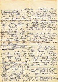
Notes - Digital Image, Cherel Sartori, Notes on conversation with Claude Amiet 1992, 1992_
Notes of Cherel Sartori's conversation with Claude Amiet in 1992 at Kell's Cottage. The house was built 1917, at 112 Henry Street Greensborough by William Mitchell on the 60 acre dairy farm owned by Ethel and Walter Kell. This collection of photographs was copied by Cherel Sartori (who owned the house from 1990-2000), following a visit by Claude Amiet who lived in the house as a child in the early 20th century.Digital copy of handwritten noteskell's cottage, claude amiet, cherel sartori -
 Mortlake and District Historical Society
Sign, 22/03/1935
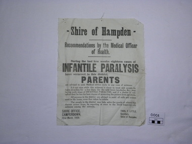
This public notice of 1935 warns of the dangers of Infantile Paralysis. It advises scalding dairy products and reporting stock illness, even though the disease was viral (discovered by U.S. researchers in 1908), not bacterial. There was little chance of protecting children against contracting the disease as the Salk vaccine was not available until 1955, although medical research into the development of preventative serum was well advanced in the 1940's. Treatment of the disease was primitive and a cure not possible.Infantile paralysis was a fearful disease increasingly prevalent in the early 20th Century. Children under 3 were especially susceptible. It could be said to be forever associated with this part of the Western District as a result of the celebrated author, Alan Marshall (1902-1984) suffering its effects. He immortalised his childhood, which was profoundly affected by his paralysis, in the autobiograhical novel 'I can jump puddles'. Calico rectangle off white"Shire of Hampden. Recommendations by the Medical Officer of Health. During the last few weeks eighteen cases of INFANTILE PARALYSIS have occurred in this district. PARENTS are advised to seek Medical advice early in any case of sickness. It is not wise while this sickness is about to treat sick people by home remedies for a few days, for the mild fever-headache, &c., may be the early stage of INFANTILE PARALYSIS, and if a doctor is consulted then he has his best chance of protecting the patient from paralysis. All persons in the district are advised to scald all milk and cream used in the home, even that taken by adults. The people in the district may help solve the puzzle of where this disease comes from, by reporting at once to the Stock Inspector any sickness among the animals. SHIRE OFFICE, CAMPERDOWN, 22nd March, 1935. THOS.F.LITTLE, Secretary, Shire of Hampden." disease, infantile paralysis, poliomyelitis, shire of hampden, public health, childhood -
 Greensborough Historical Society
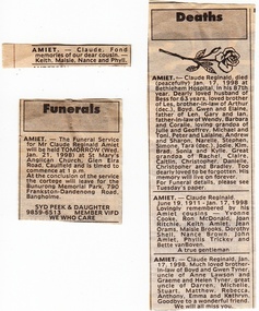
Newspaper Clipping - Digital Image, Cherel Sartori, Funeral notices for Claude Amiet 1998, 20/01/1998
Death notices collected by Cherel Sartori's following the death of Claude Amiet in 1998. Kell's Cottage was built 1917, at 112 Henry Street Greensborough by William Mitchell on the 60 acre dairy farm owned by Ethel and Walter Kell. This collection of photographs was copied by Cherel Sartori (who owned the house from 1990-2000), following a visit by Claude Amiet who lived in the house as a child in the early 20th century.Digital copy of funeral and death noticeskell's cottage, claude amiet, cherel sartori -
 Halls Gap & Grampians Historical Society
Photograph - B/W, C 1890
The man with the horse is Charles D'Alton, his cousin Alfred is beckoning him to come on. Charles was ther son of William D'Alton if "Silver Springs" on Dairy Creek, and Fred (Alfred) was the son of John D'Alton, Stawell Borough engineer. Fred and Charles were responsible for finding many of today's walking track routes through the Wonderland Range and in the Mt. Rosea area. The second copy is a transparency (slide) , no. 182 in the slide box.Photo shows man, left side corner with pack horse andother man middle ground with arm raised"Charles D'Alton beckoning to his cousin Alfred to come on" finding the best routegilbert rogers, vehicle track, people, d'alton -
 Lakes Entrance Regional Historical Society (operating as Lakes Entrance History Centre & Museum)
Photograph - Historic House, Bennett, Vera, 1991
Date made May 1991|Old building demolished c2008. Ostler family arrived at Cunninghame (Lakes Entrance) by boat, walked to the site with their belongings, cleared the land, built a dwelling, farmed dairy herd, grew maize, had beehives.| Also one colour photograph of new dwelling constructed next to the old dwelling taken 29th September 2007|Also two other colour photographs old dwelling.Colour photograph of Ostlers old home, 106 Ostlers Road, showing a timber and corrugated iron structure amongst farm buildings and trees. Lakes Entrance Victoriahouses, local history -
 Southern Sherbrooke Historical Society Inc.
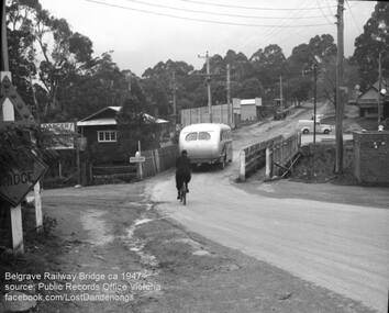
Photograph, Belgrave Railway Bridge, 1947
Belgrave railway bridge looking towards Bayview Road from Terrys Ave, 1947. It shows a bus crossing the bridge onto (now) Belgrave-Gembrook Road, followed by a male cyclist wearing a dark overcoat and bowler hat. A man wearing a homburg hat is crossing the footbridge beside the main bridge towards the main street. There is a pale van parked (or driving past) a dairy on the corner of Bayview Rd and Belgrave-Gembrook Road. A brick toilet block is shown with a sign saying 'MEN' on a nearby lamp post. -
 Ballarat Tramway Museum
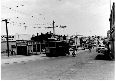
Photograph - Black & White, Bendigo 3 climbing Mitchell St, late 1950's
Black and White photograph, of Bendigo 3 climbing Mitchell St, near the Railway Station with the Destination of Quarry Hill. Has a Hutton's Ham ad on the front drivers panel and two rood ads. In the background are Sandhurst Dairies shop advertising Toppa Ice Cream, a boot repairer and a van marked Jeffreys Bread parked on the north side of Mitchell St. Nearing the point where the double track became single - see the signal wire insulators in the overhead. Printed on Fujichrome paper. Two copies held."TMSV Sales" stamp on rear. On rear of in ink 'HTT16 = MM N 102 = Geel 32 = BED 3"trams, tramways, bendigo, mitchell st, quarry hill, overhead, tram 3 -
 Bendigo Historical Society Inc.
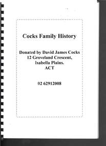
Document - COCKS FAMILY HISTORY
Forty four pages of the Cocks Family History including Acknowledgements and an introductory letter from David James Cocks. No page seven. The Cock Family came England and on arrival in Victoria the letter 's' was added to their surname. Robinson Cock came to Australia at the request of his brother-in-law, John Hunter Patterson, who owned Moorabbee Station, where he started to work. It also tells of the properties owned, horses they bred, dairy farms and later shops in Melbourne which various family members had.person, family, cocks family, cocks family history, david james cocks, robinson cocks, john hunter patterson, bendiog library, mary ann cocks (nee reeves), gwendolyn nellie pegg (nee cocks), herbert james robinson cocks (jim), leslie vincent kennett cocks (les), victor hugh cocks (hugh), herbert victor thomas cocks (bert), nellie cocks (nee mills), leslie robinson cocks, catherine cnatrill (nee cocks), herbert arthur cocks, eve ellen cocks (nee scott), leonard gibb cocks (len), raymond cocks, ingrid cocks (nee petersen), phyllis hope cocks (nee phillips), 'kimbolton', 'mcivor', john ormond randell, latrobe library, melbourne university archives, queensberry hill press, brown prior anderson p/ltd, john cock, katherine robinson, john cock, catherine shepperson -
Kew Historical Society Inc
Archive (series) - Subject File, Baby Health Centres, 1958
Various PartiesReference, Research, InformationKHS OrderSubject file containing photocopies and a journal published by the RHSV (69:1, June 1998). The article, ‘Baby Boon: The Infant Welfare Movement in Victoria’, was written by Margaret Flood. While the article only makes one reference to milk supplied by Kew dairies, it contains useful descriptions of the role of Baby Health Centres and their staff. A newspaper article/clipping (1991) refers to the establishment of the Baby Changing Room in Walpole Street. There is also a photocopy of W D Vaughan’s text on Baby Health Centres in Kew (1960).infant welfare centres - kew (vic.)infant welfare centres - kew (vic.) -
 Kew Historical Society Inc
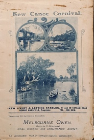
Programme, Kew Canoe Carnival, 1910
An item from an outstanding and diverse photographic collection, assembled by members of the Christian and Washfold families of Kew.Rare programme for what was once an annual event in Kew with important, possibly unique photos of sites in Kew and on the Yarra.Programme for the 1910 Kew Canoe Carnival which was held on the River Yarra on February 11th. The location was at the Asylum Reserve at the old white bridge (the precursor of Kane's Bridge). Funds were raised in Aid of the Annual Treat to Kew and Yarra Bend Patients (and the Carnival fund). The booklet includes details of the programme, numerous advertisements and rare and important historic photographs of the district including: the Willsmere Park Dairy, the Glen Tea Gardens at Hawthorn, the Pipe Bridge, the Kew Boat Sheds (Macauley's), and Rudder Grange boat house.christian-washfold collection, kew canoe club, kew canoe carnivals -
 University of Melbourne, Burnley Campus Archives
Album, Sandra Pullman, National Estate/Heritage Register Photographs, 2001
Photograph Album sent in with the National Estate/Heritage Register by Sandi Pullman. (1) Old car park (Bull Paddock) with Cork Oak. (2) Main Building front steps. (3) Main Building with Magnolia grandiflora. (4)View of Luffmann Ponds and old willow. (5) View of Ginkgo and Emily Gibson bed. (6) Looking between Emily Gibson beds to English Oak. (7) Summer House. (8) Luffmann Ponds. (9) Bergenia Walk with conifers. (10) View of Pencil Pines around entrance to Sunken garden. (11) Luffmann Ponds and Pinus canariensis. (12) View of entrance to Sunken garden. (13-14) Sunken garden. (15) Original terracing at entrance to Shady Walk. (16) Pears in blossom in Field Station. (17) Agathis robusta from the Herb Garden. (18) Ellis Stones Rock garden newly replanted. (19) james Hitchmough Grasslands. (20) Elm tree with Dairy in the background. (21) Original Red Gum in james Hitchmough Grasslands. (22) Kath Deery Native garden. (23-24) Rose Garden. (25) Sequoiadendron giganteum.national estate, heritage register, sandi pullman, sandra pullman, bull paddock, cork oak, magnolia, luffmann ponds, willow, ginkgo, emily gibson bed, english oak, summer house, bergenia walk, conifers, pencil pines, sunken garden, pinus canariensis, shady walk, pears, blossoms, field station, agathis robusta, herb garden, ellis stones rock garden, james hitchmough grasslands, elm tree, dairy, red gum, kath deery native garden, rose garden, sequoiadendron giganteum. -
 Kiewa Valley Historical Society
Photographs – Set of 4 black and white photographs. One of a wooden church and three of rural homes and farmland. Area not identified
Europeans arrived in the Kiewa and Ovens Valleys in the 1830's and 40's. Following the drought of 1838-44, seeking out the rich pastures in the fertile Valleys. It proved to be perfect conditions for dairy farming and the raising of cattle. Miners Cottages and other similar wooden structures were a common sight in the area as they were a modest form of accommodation for their period, were quick to erect and economical as they made use of locally available building materials such as local timbers.These photographs provide a snapshot into the early dwellings and architecture of the Kiewa and Ovens Valley regions, including buildings such as the church, which provided an important gathering place for social interaction, especially in these isolated areas.1-Wooden church building with no identification. Large tree in the foreground in front of church 2&3- Black and white photographs of farmland and assorted dwellings, mostly miners style cottages in a valley with mountains in the background. A bridge with wooden railings is visible over the river in the middle of the photograph, also a more modern dwelling is visible in the north east of the photograph close to the river. 4-Black and white photograph of residential homes and farmland with an unsealed road running through the middle. Foreground shows a field which has been semi cleared of trees (stumps remaining). In the background are larger farming properties with the road disappearing into the distant hills. This might be Old Tallangatta before the town was moved in 1956. 1-3 - No inscriptions 4- Signature written on back in lead pencil - Sandra Templebuildings; church; farmland -
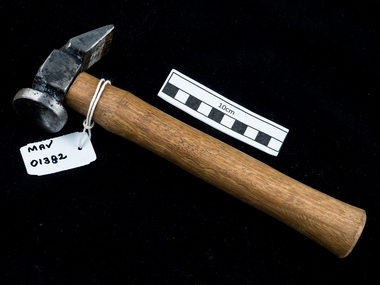 City of Moorabbin Historical Society (Operating the Box Cottage Museum)
Tool - Hammer, bootmaker c1900, c1900
Among the early settlers in Moorabbin Shire were blacksmiths who made tools for the other settlers who were establishing the homes, market gardens, farms, orchards and various businesses. Early settlers were self reliant and repaired their own equipment for kitchen,dairy, farm, horses, carts using various tools . Bootmakers made shoes for early settlers and being leather workers also made saddles and other leather productThis hammer is typical of the type used by early settlers in Moorabbin Shire c1900 Hammer with wood handle and steel head. One side of head is rounded and the other chisel shapedearly settlers, market gardeners, blacksmiths, tools, building equipment, hammers, moorabbin shire, bentleigh, mckinnon, highett, cheltenham,mcewan james pty ltd, melbourne, bunnings pty ltd,