Showing 1753 items matching "destroyed"
-
 The Beechworth Burke Museum
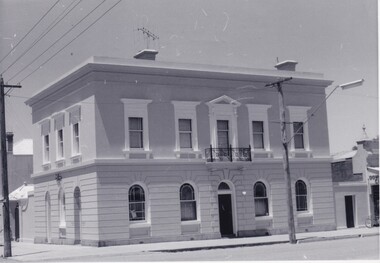
Photograph, Saunders, Unknown
The photograph depicts the two-storey building of the Bank of Victoria which was built in 1858 and was replaced in 1867 after a fire destroyed the original building. The branch had originally opened under John Farran in 1856 before the office building was erected in Beechworth. The building was located on the corner of Ford and Camp streets and embodied the dignified appearance of Beechworth during the mid-1800s due to the building's features. The Bank of Victoria was designed by "Smith and Watts" and built from white brick and render, which cost three thousand and seven hundred pounds to construct. The building was inspired by a formal Italian villa, including square-headed windows, cornices, and a parapet. The ground floor consisted of banking chambers, a strong room, and servants' quarters. The residential quarters were located on the second floor.The photograph is significant as it depicts not only depicts a building of importance to the town of Beechworth but it also shows aesthetic significance due to the style it was built in. As the Bank of Victoria was constructed in the classic Italian style, it exemplifies the classic quality and refined manner of this architectural style. This building style represents the image Beechworth held for itself at that time, which was a sophisticated and distinguished town.Black and white rectangular photograph printed on paper.Reverse: 23/80 / Beechworth / (Indecipherable) / Banking to (Indecipherable) / Sydney / “Bank of Victoria” / BMM 8692.1 / [Stamped: ILFORD]bank of victoria, beechworth, banks, beechworth bank, 1858, 1867, ford street, camp street, victoria, john farran, smith and watts, italian architecture, italian style building, brick building, brick, banking, money, fire, building destroyed -
 Warrnambool and District Historical Society Inc.
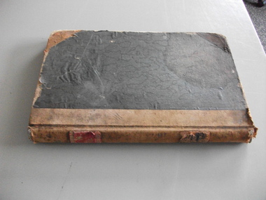
Financial record - Ledger Woollen Mill, Circa 1910
In 1869, the Warrnambool Meat Preserving Company commenced their business on the site, where it operated until 1875 when it was sold to the directors of the Warrnambool Woolen Mill Company. After being destroyed by fire in 1882 it wasn’t until 1910 that the Warrnambool Chamber of Commerce was approached by Marcus Saltau and Peter McGennan to invest in a new mill. The original directors were James Dickson, P J McGennan, Robert Swinton, M Saltau, and J W Younger. In 1955 the Warrnambool Woollen Mill formed a partnership with the Wangaratta Woollen Mills. Dunlop bought the mill in 1968. From that time until its closure in 2000 it had a number of different owners, the last being the Smith Family Industries. This register contains a list of names addresses and occupations of share holders from the period 1910 to 1944.This register provides a comprehensive listing of people who owned shares in the Warrnambool Woollen Mill in the period directly after its beginnings. It is interesting to note that the majority of share owners in the earlier days were from Warrnambool and District while entries in the later years are from further afield.Dark green cloth hard cover with tan point and spine. One red and one black label on spine with gold lettering. Pages are numbered as one number to the opened page. Entries for the most part are written in black ink. Two printed sheets from The Stock Exchange of Melbourne and National Securities are inside the front cover. W.M. Co. Share Transfer Register on labels on spine.warrnambool woollen mill, history of warrnambool, ledger warrnambool woollen mill, share register warrnambool woollen mill -
 Warrnambool and District Historical Society Inc.
Plate, Criterion Hotel Warrnambool, Early 20th Century
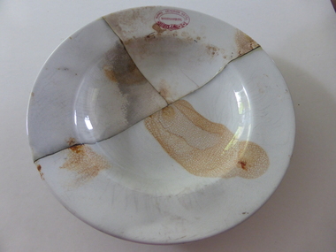
This plate has been made by the Globe Pottery Company of England and supplied by the china merchant firm of John Dynon and Sons of Lonsdale Street, Melbourne. It was used at the Criterion Hotel in Warrnambool. The Criterion Hotel, situated on the western side of Kepler Street near Lava Street, was established in 1872 with the first licensee being John Tate. The hotel closed in 2008, was partially destroyed by fire in 2010 and was demolished in 2010. This plate, being marked with the name ‘Cobridge’, was made before 1934. In the first three decades of the 20th century the licensees at the Criterion Hotel were members of the Humm family, Theresa Lynch, Henry McGennan and Margaret McGennan. The dinner plate could have been used for all or part of these years and could have been used later as well. This plate is of considerable interest as it was used at the Criterion Hotel, a prominent hotel in Warrnambool for over 130 years. This is a circular white china plate with a rim and a slight indentation at the base. There is a red embedded stamp in the shape of a belt on the top edge and the grey stamp of the maker on the bottom of the plate. This plate was probably used as a small dinner plate. There are a few small imperfections and stains on this plate.‘Criterion Hotel Warrnambool’ ‘Globe Pottery Co. Ltd. Cobridge England Vitrified, John Dynon & Sons, Melbourne’ humm family, mcgennan family, theresa lynch, criterion hotel, history of warrnambool -
 Kiewa Valley Historical Society
Photo - Bogong Township, March 1944
In 1940 Field Headquarters for the Kiewa Scheme were established at Bogong with office, workshop facilities and accommodation for workmen, staff and some families constructed. (There had been a 'tent camp' on this site in 1939 but was destroyed by bushfires) Construction of accommodation continued until 1947. A total of 40 houses plus a hostel for single staff, post office, police station, medical centre and primary school all with water and sewerage and electricity supply. The staff hostel was known as Kiewa House and is now occupied by the Education Department. Lake Guy was named after Mr. L.T. Guy who was the Resident Engineer in charge of construction work and associated activities on the Kiewa area. He held this position from 1939 to November 1946 when he was transferred to Head Office. The Bogong Township was developed firstly as an accommodation centre (base camp) for construction workers employed under the Kiewa Hydroelectric Scheme. Due to the influx of European workers into the Township the beautification of the immediate surrounds (gardens etc.) had a distinct European flavour. This environment has been very beneficial for tourism in later years. At the completion of the scheme, in the 1960's, the village was opened to public/tourism use. Strict environmental control has not allowed for any extensive redevelopment in tourist accommodation and basically restricted it to the accommodation initially built for the construction workers. Activities such a bike riding, snow skiing, restricted horse riding and bush walking on the Alpine plains and mountains are now a viable part of the Kiewa Valley Tourist Industry. The lake is one of the many water storage reservoirs used to supply the power stations their main power to run the huge turbines generating the final product, electricityBlack and white photograph of Bogong Township taken March 1944Handwritten on the back of photo - Township March '44bogong village, secv -
 Kiewa Valley Historical Society
Photograph - Bogong Village (7 copies), Approx 1940
In 1940 Field Headquarters for the Kiewa Scheme were established at Bogong with office, workshop facilities and accommodation for workmen, staff and some families constructed. (There had been a 'tent camp' on this site in 1939 but was destroyed by bushfires) Construction of accommodation continued until 1947. A total of 40 houses plus a hostel for single staff, post office, police station, medical centre and primary school all with water and sewerage and electricity supply. The staff hostel was known as Kiewa House and is now occupied by the Education Department. Lake Guy was named after Mr. L.T. Guy who was the Resident Engineer in charge of construction work and associated activities on the Kiewa area. He held this position from 1939 to November 1946 when he was transferred to Head Office. The Bogong Township was developed firstly as an accommodation centre (base camp) for construction workers employed under the Kiewa Hydroelectric Scheme. Due to the influx of European workers into the Township the beautification of the immediate surrounds (gardens etc.) had a distinct European flavour. This environment has been very beneficial for tourism in later years. At the completion of the scheme, in the 1960's, the village was opened to public/tourism use. Strict environmental control has not allowed for any extensive redevelopment in tourist accommodation and basically restricted it to the accommodation initially built for the construction workers. Activities such a bike riding, snow skiing, restricted horse riding and bush walking on the Alpine plains and mountains are now a viable part of the Kiewa Valley Tourist Industry. The lake is one of the many water storage reservoirs used to supply the power stations their main power to run the huge turbines generating the final product, electricity. Evidence can be seen of the 1939 bushfires.Set of 7 identical black and white photographs of Bogong Village after 1939 bush firesHandwritten on the back of one photo - Bogong Village approx. 1940, after 1939 bush fires. Staff residences to left. Kiewa House, General offices and test lab to the right. Hand drawn map on the back of one photo.bogong village, secv -
 Kiewa Valley Historical Society
Photo - Bogong Village Township, October 8, 1946
In 1940 Field Headquarters for the Kiewa Scheme were established at Bogong with office, workshop facilities and accommodation for workmen, staff and some families constructed. (There had been a 'tent camp' on this site in 1939 but was destroyed by bushfires) Construction of accommodation continued until 1947. A total of 40 houses plus a hostel for single staff, post office, police station, medical centre and primary school all with water and sewerage and electricity supply. The staff hostel was known as Kiewa House and is now occupied by the Education Department. Lake Guy was named after Mr. L.T. Guy who was the Resident Engineer in charge of construction work and associated activities on the Kiewa area. He held this position from 1939 to November 1946 when he was transferred to Head Office. The Bogong Township was developed firstly as an accommodation centre (base camp) for construction workers employed under the Kiewa Hydroelectric Scheme. Due to the influx of European workers into the Township the beautification of the immediate surrounds (gardens etc.) had a distinct European flavour. This environment has been very beneficial for tourism in later years. At the completion of the scheme, in the 1960's, the village was opened to public/tourism use. Strict environmental control has not allowed for any extensive redevelopment in tourist accommodation and basically restricted it to the accommodation initially built for the construction workers. Activities such a bike riding, snow skiing, restricted horse riding and bush walking on the Alpine plains and mountains are now a viable part of the Kiewa Valley Tourist Industry. The lake is one of the many water storage reservoirs used to supply the power stations their main power to run the huge turbines generating the final product, electricityBlack and white photograph of Bogong Village which appeared in the Herald Sun newspaper on October 8, 1946. Page 13Handwritten on the back - Town of Bogong on a rugged mountain slope above Lake Guy. State Electricity Committee workers on the Kiewa Hydro Electric scheme live here in all electric homes. Stamped on the back - Copyright Not for reproduction Herald Sun Feature Service Melbourne Australiabogong village; lake guy; kiewa hydro electric scheme -
 Kiewa Valley Historical Society
Postcard - Lake Guy and Bogong Village
In 1940 Field Headquarters for the Kiewa Scheme were established at Bogong with office, workshop facilities and accommodation for workmen, staff and some families constructed. (There had been a 'tent camp' on this site in 1939 but was destroyed by bushfires) Construction of accommodation continued until 1947. A total of 40 houses plus a hostel for single staff, post office, police station, medical centre and primary school all with water and sewerage and electricity supply. The staff hostel was known as Kiewa House and is now occupied by the Education Department. Lake Guy was named after Mr. L.T. Guy who was the Resident Engineer in charge of construction work and associated activities on the Kiewa area. He held this position from 1939 to November 1946 when he was transferred to Head Office. The Bogong Township was developed firstly as an accommodation centre (base camp) for construction workers employed under the Kiewa Hydroelectric Scheme. Due to the influx of European workers into the Township the beautification of the immediate surrounds (gardens etc.) had a distinct European flavour. This environment has been very beneficial for tourism in later years. At the completion of the scheme, in the 1960's, the village was opened to public/tourism use. Strict environmental control has not allowed for any extensive redevelopment in tourist accommodation and basically restricted it to the accommodation initially built for the construction workers. Activities such a bike riding, snow skiing, restricted horse riding and bush walking on the Alpine plains and mountains are now a viable part of the Kiewa Valley Tourist Industry. The lake is one of the many water storage reservoirs used to supply the power stations their main power to run the huge turbines generating the final product, electricityBlack and white photographic postcard of Lake Guy and Bogong Village. Kiewa Hydro electric Project (showing Junction Dam in front)Handwritten on the back of postcard ' Like most of our camps, this looks like something from the Canadian Rockies' Stamped on the back - Valentine's Post Card A genuine photographlake guy, bogong village, secv -
 Kiewa Valley Historical Society
Photo - Bogong Township, September 1953
In 1940 Field Headquarters for the Kiewa Scheme were established at Bogong with office, workshop facilities and accommodation for workmen, staff and some families constructed. (There had been a 'tent camp' on this site in 1939 but was destroyed by bushfires) Construction of accommodation continued until 1947. A total of 40 houses plus a hostel for single staff, post office, police station, medical centre and primary school all with water and sewerage and electricity supply. The staff hostel was known as Kiewa House and is now occupied by the Education Department. Lake Guy was named after Mr. L.T. Guy who was the Resident Engineer in charge of construction work and associated activities on the Kiewa area. He held this position from 1939 to November 1946 when he was transferred to Head Office. The Bogong Township was developed firstly as an accommodation centre (base camp) for construction workers employed under the Kiewa Hydroelectric Scheme. Due to the influx of European workers into the Township the beautification of the immediate surrounds (gardens etc.) had a distinct European flavour. This environment has been very beneficial for tourism in later years. At the completion of the scheme, in the 1960's, the village was opened to public/tourism use. Strict environmental control has not allowed for any extensive redevelopment in tourist accommodation and basically restricted it to the accommodation initially built for the construction workers. Activities such a bike riding, snow skiing, restricted horse riding and bush walking on the Alpine plains and mountains are now a viable part of the Kiewa Valley Tourist Industry. The lake is one of the many water storage reservoirs used to supply the power stations their main power to run the huge turbines generating the final product, electricityBlack and white photograph of Bogong Township taken from Little Arthur fire track. September 1953Faded handwritten inscription on back - Bogong Township taken from Little Arthur fire track. Sept 1953bogong village, secv -
 Kiewa Valley Historical Society
Photo - First Bogong Camp, September 1950
In 1940 Field Headquarters for the Kiewa Scheme were established at Bogong with office, workshop facilities and accommodation for workmen, staff and some families constructed. (There had been a 'tent camp' on this site in 1939 but was destroyed by bushfires) Construction of accommodation continued until 1947. A total of 40 houses plus a hostel for single staff, post office, police station, medical centre and primary school all with water and sewerage and electricity supply. The staff hostel was known as Kiewa House and is now occupied by the Education Department. Lake Guy was named after Mr. L.T. Guy who was the Resident Engineer in charge of construction work and associated activities on the Kiewa area. He held this position from 1939 to November 1946 when he was transferred to Head Office. The Bogong Township was developed firstly as an accommodation centre (base camp) for construction workers employed under the Kiewa Hydroelectric Scheme. Due to the influx of European workers into the Township the beautification of the immediate surrounds (gardens etc.) had a distinct European flavour. This environment has been very beneficial for tourism in later years. At the completion of the scheme, in the 1960's, the village was opened to public/tourism use. Strict environmental control has not allowed for any extensive redevelopment in tourist accommodation and basically restricted it to the accommodation initially built for the construction workers. Activities such a bike riding, snow skiing, restricted horse riding and bush walking on the Alpine plains and mountains are now a viable part of the Kiewa Valley Tourist Industry. The lake is one of the many water storage reservoirs used to supply the power stations their main power to run the huge turbines generating the final product, electricityBlack and white photo of Bogong Village. September 1950Handwritten on the back - 1st Bogong Camp. SEC Kiewa Scheme Sept 1950bogong camp, bogong village, secv -
 Kiewa Valley Historical Society
Photo - Bogong Village Township
In 1940 Field Headquarters for the Kiewa Scheme were established at Bogong with office, workshop facilities and accommodation for workmen, staff and some families constructed. (There had been a 'tent camp' on this site in 1939 but was destroyed by bushfires) Construction of accommodation continued until 1947. A total of 40 houses plus a hostel for single staff, post office, police station, medical centre and primary school all with water and sewerage and electricity supply. The staff hostel was known as Kiewa House and is now occupied by the Education Department. Lake Guy was named after Mr. L.T. Guy who was the Resident Engineer in charge of construction work and associated activities on the Kiewa area. He held this position from 1939 to November 1946 when he was transferred to Head Office. The Bogong Township was developed firstly as an accommodation centre (base camp) for construction workers employed under the Kiewa Hydroelectric Scheme. Due to the influx of European workers into the Township the beautification of the immediate surrounds (gardens etc.) had a distinct European flavour. This environment has been very beneficial for tourism in later years. At the completion of the scheme, in the 1960's, the village was opened to public/tourism use. Strict environmental control has not allowed for any extensive redevelopment in tourist accommodation and basically restricted it to the accommodation initially built for the construction workers. Activities such a bike riding, snow skiing, restricted horse riding and bush walking on the Alpine plains and mountains are now a viable part of the Kiewa Valley Tourist Industry. The lake is one of the many water storage reservoirs used to supply the power stations their main power to run the huge turbines generating the final product, electricityBlack and white photograph of Bogong Village from across Lake Guy. Photo mounted on buff cardbogong village, secv -
 Kiewa Valley Historical Society
Photograph – Set of 3 black and white photographs of Bogong Village circa late 1930's - 1940's during early construction of Lake Guy ( in the foreground), Late 1930's - 1940's
In 1940 Field Headquarters for the Kiewa Scheme were established at Bogong with office, workshop facilities and accommodation for workmen, staff and some families constructed. (There had been a 'tent camp' on this site in 1939 but was destroyed by bush fires) Construction of accommodation continued until 1947. A total of 40 houses plus a hostel for single staff, post office, police station, medical centre and primary school all with water and sewerage and electricity supply. The staff hostel was known as Kiewa House and is now occupied by the Education Department. Lake Guy was named after Mr. L.T. Guy who was the Resident Engineer in charge of construction work and associated activities on the Kiewa area. He held this position from 1939 to November 1946 when he was transferred to Head Office. The Bogong Township was developed firstly as an accommodation centre (base camp) for construction workers employed under the Kiewa Hydroelectric Scheme. Due to the influx of European workers into the Township the beautification of the immediate surrounds (gardens etc.) had a distinct European flavour. This environment has been very beneficial for tourism in later years. At the completion of the scheme, in the 1960's, the village was opened to public/tourism use. Strict environmental control has not allowed for any extensive redevelopment in tourist accommodation and basically restricted it to the accommodation initially built for the construction workers. Activities such a bike riding, snow skiing, restricted horse riding and bush walking on the Alpine plains and mountains are now a viable part of the Kiewa Valley Tourist Industry. The lake is one of the many water storage reservoirs used to supply the power stations their main power to run the huge turbines generating the final product, electricity3 black and white photographs of the Bogong camp area showing the clearing of trees for the construction of the Junction Dam and Lake Guy. Some administration buildings have been constructed, but part of the tent camp can be seen to the right of the photograph in front of the buildings. bogong village; junction dam; lake guy; kiewa hydro electric scheme; secv -
 Warrnambool and District Historical Society Inc.
Slides, Box of Glass Slides Capital Theatre, 1940s
These glass slides were made to be used at interval time at the Capitol Theatre in Kepler Street, Warrnambool. The Capitol Theatre (originally the Warrnambool Theatre) was erected in 1930 on the site occupied by the Hotel Mansions which included a Palais de Danse and a Mansions Theatre. All were destroyed by fire in 1929. The Capitol Theatre was built in the Spanish Mission style and is one of the few surviving Spanish Mission style theatres in Victoria. However the interior was largely altered in 1994 when the Capitol was converted into a three-screen complex. But some decorative features of the old interior were kept and these included the original proscenium. Stan Stevens and his family were associated with the Capitol Theatre management for many years from 1972. The Capitol Theatre still operates today. These slides are of considerable importance as they are a wonderful example of picture theatre-going in the 1940s and 50s when slides were shown during the interval times and many of these were locally made. The reason for showing the words of songs is not known but it is presumed they had sing-a-longs during the intervals, possibly to boost morale during the days of World War Two. The advertising slides are of particular interest and feature such local businesses as the Woollen Mill, Sungold Dairies, E.A. Wright Motors and Alex Donaldson Timber and Hardware Supplies. These are small square glass slides (numbered1 to 92) which were shown in the 1940s at the Capitol Theatre in Warrnambool at interval time (advertisements, words of songs etc). Some of the slides have been professionally produced and some, especially the words of songs, have been hand-made and handwritten or typed. Some are in colour and some are blank. In others the contents have been obscured or obliterated. Most of the slides have been taped around the edges and some have more sturdy frames made of tape. capitol theatre, warrnambool, stan stevens -
 Warrnambool and District Historical Society Inc.
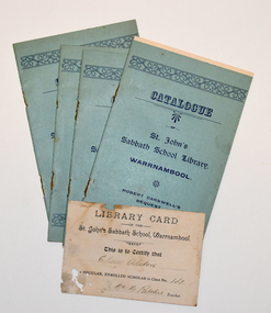
Booklet - Sunday School library catalogue and card, Smith's Printing Works, Warrnambool, early 20th century
The booklet is a catalogue of the books in the Warrnambool Presbyterian St. John's Sabbath School Library (Robert Carswell's Bequest) early in the 20th century. The books for boys and girls are listed separately and are mostly fiction, many with some religious content. St John's Presbyterian Church was opened in 1875. The building was destroyed by fire in 1920 and rebuilt in a similar style to the original one. Robert Carswell was a Warrnambool resident who died in 1900 at the age of 77 and it is presumed that the bequest from his will enabled the Sunday (Sabbath) School library to be established. The card is a membership certificate indicating that Elsie Alston was enrolled as a Sunday School member in Class 14 and thus entitled to borrow books from the library. No details have been found on Elsie Alston but there were several Alston families in Warrnambool at the time.These items are of some interest as church Sunday Schools in the past, particularly in the 19th century, were important as they were widely attended and provided a range of educational and recreational activities, often not otherwise available to the children at that time'.1 A booklet of ten pages with a blue cover with blue printing and a decorative border on the front. The pages contain printed material. The booklet was once stapled but the staples have been removed. .2 A white card with black printing and handwritten names.Elsie Alston Mr M. Ritchieelsie alston, robert carswell, st. john's sabbath school warrnambool, sunday schools in warrnambool -
 Warrnambool and District Historical Society Inc.
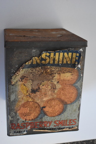
Biscuit Tin, Ballarat Products Limited (Sunshine Biscuit Co.), Mid 20th century
This tin came from the Sunshine Biscuit Factory in Ballarat. James Long established a confectionery business in Ballarat in 1854 and in 1921 it was known as the Sunshine Biscuit Company. In 1923 the factory was destroyed by fire and rebuilt. During World War Two 80% of the factory products went to the armed services. In 1947 the company was known as Ballarat Products Ltd and in 1962 it was called Sunshine Biscuits Ltd. In 1977 the factory was used to produce dry pet food (Friskies). The building was closed in 1991 and the site developed to include a supermarket, shops and housing. Up till about the late 1950s biscuits were mostly not packaged but sold loose by the pound in grocery stores from tins such as this. Broken biscuits were also sold at a cheaper price. Some biscuits were also sold at that time in smaller tins. This tin is of interest as an example of the tins from which biscuits were sold in the first half of the 20th century. It will be useful for display.This is a rectangular-shaped biscuit tin which is much rusted. The tin has a multi-coloured paper label that has been pasted around the sides. Much of this label has been torn away. The label shows images of biscuits. There is printing on the label and on the bottom of the tin. ‘Sunshine Raspberry Smiles’ ‘Ballarat Products Ltd.’ ‘This tin is not sold with the contents thereof but remains the property of Sunshine Biscuit Co Ballarat’ ‘Made in Australia 054’ sunshine biscuit factory, ballarat, history of warrnambool -
 Warrnambool and District Historical Society Inc.
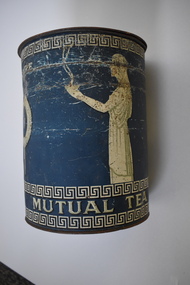
Tea Tin, Mutual Store Ltd, Mid 20th century
This tin contained bulk tea which came from the Melbourne Mutual Store. Established in 1872 as a profit-sharing co-operative of shareholders and staff, Mutual Store Ltd was situated at the corner of Flinders and Degraves Street, Melbourne. Fire destroyed the building in 1891 and the new building erected is an important heritage building today. In 1961 Peter Kaye Consolidated Ltd bought the business and it then traded as Mutual Store Holdings Ltd. In 1964 Cleckheaton (from England) took over the business and closed the store in 1965. Tea tins such as this one would have been distributed by the Mutual Store to smaller businesses such as cafes or repackaged for sale at grocery shops etc. Bulk tea can still be bought but the main tea sales are now in the form of tea-bags. This tin is retained as a memento of the days in the 19th and early to mid 20th centuries when tea was sold only in bulk and provided in tins such as this by the importers to small grocery shops and the like. This is a tea tin, cylindrical in shape. It has a tight-fitting lid with a metal clip. There is blue and cream painting around the sides of the tin with images of Greek figures and a wreath with a ribbon. The tin is much scratched and rusted. There is cream printing on the tin.‘Mutual Tea’ ‘Mutual Store Ltd Flinders Street Melbourne Aust. ‘ ‘5 lbs nett’ mutual store, melbourne, warrnambool -
 Eltham District Historical Society Inc
Photograph - Black and White Print, Hector John McLean, Pioneers of Eltham, 1st prize in Group Section, Centenary Parade, Eltham Lower Park, 15 Dec. 1934
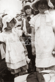
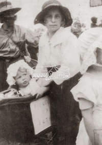
The McLean family, Hector John McLean and Louisa Frances (nee Green) and six daughters lived in Eltham during the period 1930 to 1934 inclusive. Lived in the former Evelyn Hotel at the time it was destroyed by fire in 1931. On December 15, 1934 the six girls all participated in the Centenary Parade dressed up as Pioneers of Eltham. They were dressed as the father and mother, two girls, a boy and a baby in a pram. They had to walk from their home in Eltham South to the railway station where the parade commenced and back to Eltham Park (Eltham Lower Park). The family won the Group Section for their entry “Pioneers of Eltham”. Jean (13) was dressed as the father, Edith (12) as the mother, Isabel (8) as the son, Gwen (6), Phoebe (5) as themselves and baby Gwladys (1) as the baby in the pram. centenary celebrations, centenary parade, dorothy jean mclean, edith jones (nee mclean), eltham lower park, eltham railway station, gwenneth mae mclean, gwladys evelyn mclean, hector john mclean, louisa frances mclean (nee green), olive isabel mclean, parade, pioneers of eltham -
 Eltham District Historical Society Inc
Photograph - Black and White Print, Hector John McLean, Pioneers of Eltham, 1st prize in Group Section, Centenary Parade, Eltham Lower Park, 15 Dec. 1934
The McLean family, Hector John McLean and Louisa Frances (nee Green) and six daughters lived in Eltham during the period 1930 to 1934 inclusive. Lived in the former Evelyn Hotel at the time it was destroyed by fire in 1931. On December 15, 1934 the six girls all participated in the Centenary Parade dressed up as Pioneers of Eltham. They were dressed as the father and mother, two girls, a boy and a baby in a pram. They had to walk from their home in Eltham South to the railway station where the parade commenced and back to Eltham Park (Eltham Lower Park). The family won the Group Section for their entry “Pioneers of Eltham”. Jean (13) was dressed as the father, Edith (12) as the mother, Isabel (8) as the son, Gwen (6), Phoebe (5) as themselves and baby Gwladys (1) as the baby in the pram. centenary celebrations, centenary parade, dorothy jean mclean, edith jones (nee mclean), eltham lower park, eltham railway station, gwenneth mae mclean, gwladys evelyn mclean, hector john mclean, louisa frances mclean (nee green), olive isabel mclean, parade, pioneers of eltham -
 Bendigo Military Museum
Photograph - PHOTOGRAPHS, 1939-1945
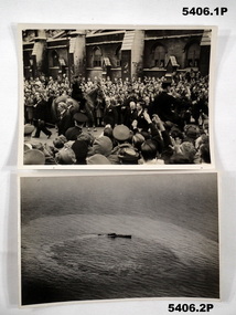
Donated by W.G. Selwyn 421514 RAAF .1) Sir Winston Churchill in centre of a crowd. .2 This photo is the same as the Imperial War Museum photo, item C3780. U 459 was scuttled after being severely damaged by the RAF. 24 JULY 1943. .3 This photo is the same as the Imperial War Museum photo, item C3543. Its caption is titled "TWO AUSTRALIAN SUNDERLANDS DESTROY A U BOAT". caption reads..."Original wartime caption: Depth charges from Sunderland "P" straddling U-boat which had been apparently partially disabled by "F"'s attack and unable to crash dive. Wake shows U-boat still capable of considerable surface speed, unsuccessfully attempting to evade the Sunderland's attack, which ultimately "killed" it."..1) Photograph- black and white, crowd, horse and Sir Winston Churchill .2) Photograph- black and white photo of a submarine circling and damaged after air attack ..3) photograph- black and white white photo, submarine under air attack from Australian Sunderland aircraft.photograph, sir winston churchill, u boats second world war., u 459. -
![Photograph - Digital image, Willis Vale [2], 1950c](/media/collectors/4f729f5697f83e03086015b8/items/54fd41442162f10d30bf885f/item-media/54fd41912162f10d30bf8caa/item-fit-380x285.jpg) Greensborough Historical Society
Greensborough Historical SocietyPhotograph - Digital image, Willis Vale [2], 1950c
View of Greensborough in the distance from Willis Vale and surrounding land: House built by Edward Maygar, The flowering Hawthorne Bushes were planted by William Partington. Note the prominent house on upper right where Robert Whatmough lived in the mid 19th century and later sold to Partington family. It was located on the Plenty River across from Partington's Flat. The derelict Willis Vale house was destroyed in 1964 when a fire originating from North Plenty Gorge - Kurrak Road - was lit by two teenage boys and made its way several kilometres down to Partington's Flat Greensborough. In 1946, Alan Partington built the Alwyn Farmhouse in place of the original Robert Whatmough home seen in this photo which became Whatmough Park circa 1976.Home of the Partington familyDigital copy of black and white photograph.willis vale, partington family, maygar family, whatmough -
 Kiewa Valley Historical Society
Photograph from Lake Guy, Bogong Village, Scene from shores of Lake Guy to Mountain range, 1930s to 1950s
In 1940 Field Headquarters for the Kiewa Scheme were established at Bogong with office, workshop facilities and accommodation for workmen, staff and some families constructed. (There had been a 'tent camp' on this site in 1939 but was destroyed by bushfires) Construction of accommodation continued until 1947. A total of 40 houses plus a hostel for single staff, post office, police station, medical centre and primary school all with water and sewerage and electricity supply. The staff hostel was known as Kiewa House and is now occupied by the Education Department. Lake Guy was named after Mr. L.T. Guy who was the Resident Engineer in charge of construction work and associated activities on the Kiewa area. He held this position from 1939 to November 1946 when he was transferred to Head Office.The Bogong Township was developed firstly as an accommodation centre (base camp) for construction workers employed under the Kiewa Hydroelectric Scheme. Due to the influx of European workers into the Township the beautification of the immediate surrounds(gardens etc.) had a distinct European flavour. This environment has been very beneficial for tourism in later years. Strict environmental control has not allowed for any extensive redevelopment in tourist accommodation and basically restricted it to the accommodation initially built for the construction workers. Activities such a bike riding, snow skiing, restricted horse riding and bush walking on the Alpine plains and mountains are now a viable part of the Kiewa Valley Tourist Industry. The lake is one of the many water storage storage reservoirs used to supply the power stations their main power to run the huge turbines generating the final product, electricityThis black and white photograph shot from the shores of Lake Guy toward the mountain range of the Victorian Alps details the early construction of the construction worker's accommodation of the Bogong Village. The paper is of 200gms and is not photographic paper and can be assumed to be a reproduction of an original photobogong village circa 1930 to 1950, kiewa hydro-electricity scheme, victorian alpine region mid 1900s -
 Kiewa Valley Historical Society
Photograph of Lake Guy and Bogong Village, Lake Guy and Bogong Village, Approx. 1945
In 1940 Field Headquarters for the Kiewa Scheme were established at Bogong with office, workshop facilities and accommodation for workmen, staff and some families constructed. (There had been a 'tent camp' on this site in 1939 but was destroyed by bushfires) Construction of accommodation continued until 1947. A total of 40 houses plus a hostel for single staff, post office, police station, medical centre and primary school all with water and sewerage and electricity supply. The staff hostel was known as Kiewa House and is now occupied by the Education Department. Lake Guy was named after Mr. L.T. Guy who was the Resident Engineer in charge of construction work and associated activities on the Kiewa area. He held this position from 1939 to November 1946 when he was transferred to Head Office.This photograph is an excellent historical record of Bogong Village in about 1945. It shows the layout of the town in the fairly steep terrain, the workmen's camp between the houses and the lake foreshore, the Commissioner's Lodge on the hill behind the Village, the walkway through the dam wall can be seen to the left of the spillway, the dam is on spill and note damage to the large trees is still evident from the 1939 bush fires. The Commissioner's Lodge was lost in the 2003 fires and the camp buildings were in service until 1962, when they were removed and the site converted into a public picnic area with lawns and gardens.A Black and white photograph"Lake Guy and Bogong" hand written on back of photograph.kiewa, accommodation, lake, dam, bogong -
 Warrnambool and District Historical Society Inc.
Artefact, China Plate, 1922 (painting)
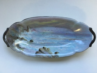
This plate was painted by J.J. Forrester in 1922. John James Forrester, the son of John Lamb Forrester and Maria Hexter, was an architect in Warrnambool in the early 20th century. He had an office in Kepler Street (1910) and in Koroit Street (1916). He lived in the house in Liebig Street that was formerly the first Savings Bank and was erected in 1860 (7A Liebig Street today). Forrester was a staunch member of the Presbyterian Church and was the co-architect for the re-building of the interior of St. John’s Presbyterian Church in Warrnambool after it was destroyed by fire in 1920. John Forrester was also a noted artist of his time and several of his works of art have survived. A landscape by him is in the possession of the Warrnambool and District Historical Society. This plate is one of two painted by Forrester that survive today.This plate, although damaged, is of interest because it was painted by John James Forrester, a Warrnambool artist from the early 20th century. This is a china plate showing a seascape painted by John James Forrester in 1922. It depicts a coastal scene of rocks, birds and sailing boats. The colours are in mauve/brown/ white tonings and are slightly opalescent. The plate has brown/grey handles with one broken and repaired. The plate is oval-shaped with a slight dip and a stand at the base. Front of plate: ‘J.J.F.’ On base: ‘J.J. Forrester 1922’ john james forrester, history of art in warrnamool, history of architecture in warrnambool, history of warrnambool, china painting -
 Warrnambool and District Historical Society Inc.
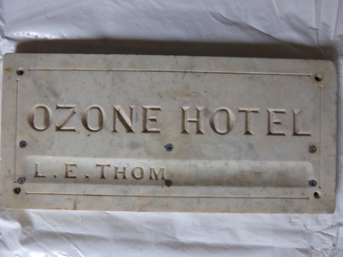
Plaque, Ozone Hotel, 1890
The building to which this tablet was attached was erected in 1890 as the Grand Ozone Coffee Palace. It was at the corner of Koroit and Kepler Streets in Warrnambool and was the most splendid edifice ever erected in Warrnambool. Initially it was a Temperance Hotel but in 1891 it gained a colonial wine licence. Thomas Randall was the lessee and proprietor of the building from 1894 to 1907 and from 1895 on it was called the Ozone Hotel. Mrs Lillias Euphemia Thom was the proprietor from 1907 to 1910. The tablet described herein has her name incised on the tablet ‘L.E.Thom’. The hotel was closed in 1915 and re-opened in 1920 with the new name of Hotel Mansions. The proprietor at that time was Howard Lawson. In 1923 Hotel Mansions gained a full hotel licence but in 1929 the building was destroyed by fire. The present day Hotel Warrnambool now occupies the site of the Hotel Mansions. This tablet is of great significance as it is an important memento of the Grand Ozone Coffee Palace/Ozone Hotel/Hotel Mansions. This building was the most elegant building ever to be erected in Warrnambool and, as such, a reminder of the type of luxury accommodation offered to visitors to Warrnambool in the late 19th and early 20th centuries. This was a time when Warrnambool was promoted as a spa resort with hot and cold sea baths and bracing sea breezes. The marble tablet is an indication of the splendor of the hotel’s furnishings and accoutrements. This is a rectangular marble slab with incised gold lettering (now somewhat faded). The bottom lettering is contained in a slight groove in the marble. There are four holes at each corner and six smaller holes along the edges of the tablet for attachment by screws to a building. The slab has some staining and a little rust. ‘Ozone Hotel’ ‘L.E.Thom’ grand ozone coffee palace (warrnambool), ozone hotel (warrnambool), hotel mansions, history of warrnambool, lillias thom -
 Warrnambool RSL Sub Branch
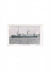
POSTCARD 29 December 1915 to MADGE from H.M.A.T. 'DEMOSTHENES' just after embarkation. Secretly married, Bob addresses his wife as 'Miss McLaughlin' c/- her parents. PICTURE POSTCARD of 8th Reinforcements, 6th Field Ambulance, photographed on board the Demosthenes. Every member's name has been carefully recorded by Bob on the reverse side. PHOTOS x 2: Fancy Dress on board Demosthenes. POSTCARD 2 January 1919 to MADGE from Belgium. By this stage, Madge had stopped writing to Bob after she was shown Bob's '2nd Trip to Paris' letter (15 August 1918) by her mother-in-law. By now, Bob had virtually given up on the marriage
This is one of the very few surviving pieces of correspondence between Bob and his wife, Madge. Bob destroyed the bulk of such correspondence between the pair, although some of Bob's typed letter/stories that Bob sent to Madge survived, pasted into a large hard-backed journal, and later passed on to grand-daughter, Margaret Davey. The Registry Office marriage was a secret business. Perhaps an Irish nationalist, Madge's father, Andrew McLaughlin, had absolutely forbidden any of his daughters to marry a soldier. The Snapes were taken by surprise too and Madge wore the wedding ring on a string about her neck. Bob wrote to Madge McLaughlin c/- her parents's home in at 22 Hull Street, Richmond (near West Richmond Railway Station).Picture Postcard.snape collection -
 Bacchus Marsh & District Historical Society
Photograph, Cheese Factory Waddell Street Bacchus Marsh 1883
The Cheese Factory in this image was opened around 1879 by Mr. G.G. Pearce. It was in Waddell Street. It was one of the first cheese factories in Victoria. It was later owned and operated by William Telford with the assistance of John Mahon. The factory was described in the Bacchus Marsh Express newspaper as an important business and service for the region. G.G. Pearce was reported to have spent a good deal of money in setting up the factory to ensure it was one which produced high quality cheese using modern methods of production. The factory was sold in 1889 to a Mr. H. W. King who was from Abbotsford in Melbourne. Unfortunately within a few days of Mr King buying the factory it was completely destroyed in a fire. All that was left were two large pine trees and two large underground concrete tanks.G.G. Pearce was described as a pioneer of cheese factories in Victoria. His first factory was just outside of Bacchus Marsh at Hopetoun. Around 1879 he moved into Bacchus Marsh and opened a new purpose built factory in Waddell Street. The Bacchus Marsh Express newspaper reported that no expense had been spared in constructing this factory. The factory was completely destroyed in a fire in 1889 which makes it fortunate that this image was captured of this early cheese factory in Victoria.Small sepia unframed photograph on card with gold border framing photograph. Housed in the album, 'Photographs of Bacchus Marsh and District in 1883 by Stevenson and McNicoll'. The image shows a group of men and women standing in a row in front of the Bacchus Marsh Cheese factory. One of the women is holding a small child. In front of another woman stands a young boy. Behind them is a covered wagon with a man seated upon it. Some of the men and women are wearing long aprons. In the background is the Cheese Factory. It is a large wooden structure with a high and steep pitched roof.On the front: Stevenson & McNicoll. Photo. 108 Elizabeth St. Melbourne. COPIES CAN BE OBTAINED AT ANY TIME. On the back: LIGHT & TRUTH inscribed on a banner surmounted by a representation of the rising sun. Copies of this Portrait can be had at any time by sending the Name and Post Office Money Order or Stamps for the amount of order to STEVENSON & McNICOLL LATE BENSON & STEVENSON, Photographers. 108 Elizabeth Street, MELBOURNE stevenson and mcnicoll 1883 photographs of bacchus marsh and district, cheese factories, bacchus marsh cheese factory -
 Sunbury Family History and Heritage Society Inc.
Photograph, Sunbury & District Heritage Association Inc, Vineyards Exhibition, August 1996
The vineyards exhibition was mounted by the Sunbury & District Heritage Association in the former George Evans Museum from August 1996 to January 1997. It featured the establishment of the vineyards and the wine industry in Sunbury from the 1860s to the present day. From the early days of European settlement in Sunbury, it was found that the soils and climate suited the growing of grapes, especially the east facing slopes along Vineyard Road. A number of people of German origin established vineyards along there. By the end of the nineteenth century and limited spending power as a result of the 1890s depression, the demand for wine declined in Victoria with beer being the preferred beverage.While Phylloxera destroyed the vines in many areas of Victoria, Sunbury's grapevines were not affected. As the demand for wine increased in the 1960s - 70s, some vineyards in the Sunbury area were replanted.The vineyards established in Sunbury in the 1860s were one of the earliest agricultural pursuits taken up by European settlers in the area and remained an important industry for 40 years.A non-digital coloured photograph of a display board advertising an exhibition of vineyards in the Sunbury area.vineyards, sunbury, vignerons, wine production -
 Warrnambool and District Historical Society Inc.
Booklet, Warrnambool Woollen Mill 1951-53, 1953
In 1869, the Warrnambool Meat Preserving Company commenced their business on the site, where it operated until 1875 when it was sold to the directors of the Warrnambool Woolen Mill Company. After being destroyed by fire in 1882 it wasn’t until 1910 that the Warrnambool Chamber of Commerce was approached by Marcus Saltau and Peter McGennan to invest in a new mill. The original directors were James Dickson, P J McGennan, Robert Swinton, M Saltau, and J W Younger. In 1955 the Warrnambool Woollen Mill formed a partnership with the Wangaratta Woollen Mills. Dunlop bought the mill in 1968. From that time until its closure in 2000 it had a number of different owners, the last being the Smith Family Industries. This report contains the financial reports for the three years from 1951-1953.This report shows records of the Woollen Mill which was one of the most important industries in Warrnambool for nearly 100 years. As such it has links to many local families and organisations.Light brown paper cover with black text underlined in red. Bound in black tape. Accountants’ name along bottom of cover in black.warrnambool, warrnambool woollen mill, warrnambool woolen mill, -
 Seaworks Maritime Museum
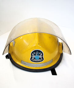
Firefighter helmet, Pacific Helmets (NZ) Ltd
Yellow fire fighter helmet with blue logo and orange fittings and reflecting tapeBROWN/Prosperity through service/ 11530/ Brown/ Fireman's helmet/3/Model Pro Helmets/ Size Date Batch (WGT 1215/ N.F.P.A. 1972/1985 Instructions to user : shell and liner constructed of fibreglass and polyethylene lining helmet can be seriously damaged by substances such as petrol, paint, adhesives or cleaning agents. Make no modifications. Fasten helmet securely. If helmet experiences a severe blow return it to the manufacturer for inspection or destroy and replace it. WARNING: no helmet can protect the wearer from all injuries. The manufacturer accepts no liability for injuries resulting from or during the use of this helmet/ MANUFACTURED BY PACIFIC HELMETS (NZ) LTD. WANGANUI. NEW ZEALAND. -
 Ballarat Tramway Museum
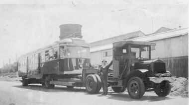
Photograph - Black & White Photograph/s, Yellow Express, 1942
Black and white photograph of Victorian Railway's Tram No. 52 being delivered to Elwood depot during 1942 by Yellow Express prime mover and low loader trailer - Truck registration - DP 635. Has the depot and water tower in the background and a person, the driver? alongside the truck. See image i1 for the details on the rear. Destination City, 4th Edition for date of manufacture.On rear of photograph in ink. 1. On left hand edge "PS can destroy photo when finished" 2. On upper 2/3rds of back "Photo wires being taken down to allow 1/2 section house to past it being 19-6 x 48 x 23 wide. Transported Preston to Reservoir by Yellow Express Melbourne Victoria" - would appear to refer to another photograph. - Dimensions in feet? 3. On lower 1/3rd, "Tram being transported Newport Railway Workshops to Elwood Depot , 11 mile. 45 long x 8-6 x 10 / Yellow Expx". Dimensions in feet.trams, tramways, vr, st kilda brighton tramway, elwood depot, vr class tramcars, yellow express, tram 52