Showing 1204 items
matching land for sale
-
 Clunes Museum
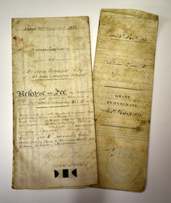
Document - LAND PURCHASE AGREEMENT, 1862
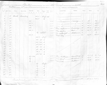
... SALE OF CROWN LAND IN VICTORIA 1862... PURCHASE AGREEMENT Document SALE OF CROWN LAND IN VICTORIA 1862 ...SIGNED IN MELBOURNE 29 TH MARCH 1862 BY SIR HENRY BARKLEY GOVENOR-IN-CHIEF OF THE COLONY OF VICTORIASALE OF CROWN LAND IN VICTORIA 1862TO ABEL GRENFELL OF CRESWICK. LAND SITUATED IN ALLIANCE STREET, CLUNES.local history, document, land purchase, government, colonial government -
Port Melbourne Historical & Preservation Society
Archive - Alan Mathews and family, 23 Jun 1938
The Mathews family have been in continuous ownership of 395 Howe Parade (was 8 Howe Parade until 1964 when addresses re-assigned), Port Melbourne from 1938 to the present (Sept 2019)Six folders of assorted documents relating to the life of Alan Mathews and his family. Documents relating to the purchase of residence on Howe Parade. The Commissioners of the State Savings Bank of Victoria with Mr J E Mathews Factory Foreman, 2 Eveline Street East Brunswick. Contract of sale of a dwelling House and land 8 Howe Parade Garden City. Contract signed 7.11.1938built environment - domestic, banking, alan mathews -
 Bacchus Marsh & District Historical Society
Map, Bacchus Marsh Township and Nearby Districts Maps Volume
This volume of maps is believed to have been compiled by staff at the Shire of Bacchus Marsh and was presumably used to inform and assist Shire staff and Councillors in the carriage of their duties.This collection of maps are significant due to their rarity as many of them are unique maps made for local purposes in the Bacchus Marsh region. They are also of strong research value containing a wide variety of information including landholders, land sales, infrastructure, such as roads, bridges, public, commercial and private buildings, houses, land use, and geographic features over multiple decades from the late nineteen century into the middle part of the twentieth century.One bound volume of maps comprising cadastral maps, (indicating property owners and land boundaries), land plans and real estate auction plans and advertising material, and other maps indicating major infrastructure like proposed roads and irrigation areas. Most of the maps and plans are of Bacchus Marsh and nearby areas but some maps are of nearby towns such as Melton, Ballan and Blackwood. The volume comprises 52 pages. Most pages have a single map or plan pasted onto it but some contain 2 or 3 different maps. There are 81 maps in total. Map 1 Liquidators Sale 1896. Map 2. Woodside Estate Sale 1913. maps, maps bacchus marsh, maps bacchus marsh region -
 Ringwood and District Historical Society
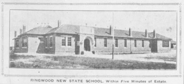
Photograph, Ringwood State School, Land sale brochure image - November, 1923
... Ringwood State School, Land sale brochure image - November...Photograph Ringwood State School, Land sale brochure image ...The same photo 2094b also appear in the Real Estate and Home Journal 15 January 1925 P17. -
Bialik College
Mixed media (series) - Sites & Premises: fundraising appeals and plans for development
1990s, 2000s, 1980s, buildings, development, planning, shakespeare grove, elc, 1970s1990s, 2000s, 1980s, buildings, development, planning, shakespeare grove, elc, 1970s -
Whitehorse Historical Society Inc.
Letter - Correspondence, Lots on Greenleigh Heights Estate, 1931
A letter to A. Roy Charlesworth, Shire of Blackburn and Mitcham, offering lots for sale at Greenleigh Heughts estate.A letter to A. Roy Charlesworth, Shire of Blackburn and Mitcham, offering lots for sale at Greenleigh Heights estate.A letter to A. Roy Charlesworth, Shire of Blackburn and Mitcham, offering lots for sale at Greenleigh Heughts estate.greenleigh heights estate, charlesworth, albert roy, shire of blackburn and mitcham, land sales -
Canterbury History Group
Map - Canterbury. Sale of the season, c1929
Photocopy of sale notice for 28 mansion and villa sites in area bordered by Kent Avenue, Mont Albert Road, Faversham and Chatham Roads 29 September [1929]canterbury, mont albert road, faversham road, kent avenue, chatham road, flere & co, land subdivision, auctions -
Canterbury History Group
Pamphlet - Ye Heights of Canterburie; Ye Star of the Eastern Suburbs, 1887
Photocopy of brochure advertising sale by auction of ' 70 Business and Villa sites' in Canterbury on 10 December 1887.Includes map of the allotments.canterbury, canterbury road, church street, highfield road, margaret street, land subdivision, flint> f.l, auctioneers -
Canterbury History Group
Pamphlet - Range Estate, Canterbury, 1/04/1916 12:00:00 AM
Photocopy of a Coghill & Haughton brochure advertising the sale by auction of '19 superb Villa and Mansion' sites in Canterbury on 15 April 1916. Includes map of the allotments and photographs of five existing homes on the estate.canterbury, balwyn road, hopetoun avenue, mont albert road, view street, coghill & haughton, auctioeers, land sales, grange estate -
 Ringwood and District Historical Society
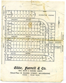
Document, Glen Turnbull, Land Sale Brochure - Heathmont Hills Estate - subdivision of Stan Wieland's Land (undated), 25/2/2008
... Land Sale Brochure - Heathmont Hills Estate - subdivision...Document Land Sale Brochure - Heathmont Hills Estate ...Small brochure by Glide Farrell & Co, real estate and Business Agents, Melbourne advertising "93 Superb Building Blocks 3Mins Station & Shops", and "Sky-Line Views of Heathmont Hills Estate" , comprising lots in Dresden Ave, Doulton Ave, Devon Ave, Viviana Crescent, Leoni Avenue. -
 Whitehorse Historical Society Inc.
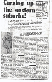
Print - Article, Carving up the Eastern Suburbs, 8/11/1972 12:00:00 AM
Photocopy of book review of Michael Cannon's 'Land Boom and Bust' describing the work of land speculators in the 1880's.Photocopy of book review of Michael Cannon's 'Land Boom and Bust' describing the work of land speculators in the 1880's. The involvement of senior politicians is discussed. Sir Matthew Davies and the Freehold Investment Company in Blackburn and the sale of the Blackburn Park Estate is mentioned. A copy of a Queen's Park, Box Hill 10 pound deposit receipt is illustrated.Photocopy of book review of Michael Cannon's 'Land Boom and Bust' describing the work of land speculators in the 1880's. davies, matthew henry, sir, bent, thomas, benjamin, freehold investment and banking company of australia ltd., blackburn and tunstall property co., queens park estate, box hill, residential development -
 Whitehorse Historical Society Inc.
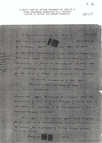
Letter - Correspondence, Orchard Mitcham Road, 1/09/1928
Draft form of an option prepared in 1928 by Melbourne barrister R.G. MenziesPhotocopy of draft form of an option prepared in 1928 by Melbourne barrister R.G. Menzies for the sale of an orchard in Mitcham Road, Mitcham.Draft form of an option prepared in 1928 by Melbourne barrister R.G. Menziesorchards, land sales, menzies, robert gordon, sir, mitcham road, mitcham -
 Whitehorse Historical Society Inc.
Document - Report, Nunawading land, 01/10/1855
Photocopies of 3 sheets of documents in the Public Record Office listing the first land purchases in Nunawading. Headed: 'Final Report of a sale by public auction of suburban and country lands held at Melbourne on the 22nd October 1855'.williams, william, cousens, james, heading, nalborough, phillip, riley, patrick, blood, thomas, cook, holland, john, lobb, burrell, charles, land subdivision -
 Kiewa Valley Historical Society
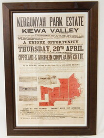
Poster - Framed - Kergunyah
... of the advertising of the sale of land in 1922, the size of land & blocks ...in 1922 Kergunyah Park homestead was built by David Wallace in the late 1800's and remained in the family until the sale in 1922 when it was bought by John Woodside (grandfather of Ewen Wallace) whose family retained it until 1938. Another family named Wallace bought the property in 1938 and this family's descendants are still running it in 2005.David and Henrietta Wallace purchased the original holding and built Kergunyah Park homestead in the late 1800's running cattle on the property. They arrived in Australia in 1867 with their 3 children and were early settlers in the district. Their descendants still live in the district. Their family demonstrates how properties were passed on to the next generation. The poster is an example of the advertising of the sale of land in 1922, the size of land & blocks and the conditions of sale at the time.Large cloth map mounted under glass with a brown wooden frame. Brown writing detailing Kergunyah Park 1923 Sale Record. Includes 4 rectangular brown and white photos and a red map showing 13 blocks of land. Has hanging wire attached on the back."Framed by / Clarkson Collection / Ph; 02 6059 6800"kergunyah. kiewa valley. kergunyah park homestead. ewen wallace. john woodside. -
Kew Historical Society Inc
Plan - Subdivisional Sale of 11 Villa Sites, East Kew, 1939
Subdivision plans and real estate flyers/brochures reveal a number of aspects of urban development and history. The Kew Historical Society's collection of these plans, as well as advertisements extracted from magazines, cover key aspects of community development and architectural history of Kew and Kew Eat as well as surrounding suburbs. While most of the plans in the collection were gifted to the Society by the former City of Kew, a number of other plans and advertisements have been donated by individuals, of which this is an example.Single page residential subdivision plan advertising house lots for sale, in what was then designated as East Kew but is now Kew, in the following streets: Burke Road, Enfield Street. The flyer includes a smaller locality plan at right. Information on the flyer indicates that the land was previously owned by the Melbourne & Metropolitan Tramways Board.subdivision plans -- kew (vic.), enfield street -- kew (vic.), burke road -- kew (vic.) -
Kew Historical Society Inc
Booklet - Old Kew Golf Links Estate, 1926
Subdivision plans and real estate flyers/brochures reveal a number of aspects of urban development and history. The Kew Historical Society's collection of these plans, as well as advertisements extracted from magazines, cover key aspects of community development and architectural history of Kew and Kew Eat as well as surrounding suburbs. While most of the plans in the collection were gifted to the Society by the former City of Kew, a number of other plans and advertisements have been donated by individuals, of which this is an example.8-page brochure advertising 80 residential home sites for sale in a subdivision called the 'Old Kew Golf Links Estate'. These sites had historic importance in Kew's history as they had previously belonged to Kodak Pty Ltd who were refused permission by Kew Council to use the land for industrial development. The estate, advertised was advertised as being within five miles of Melbourne. The brochure is notable as it includes photographs of Kew East Primary School, the former Kew Golf Club clubhouse, and 'The Moorings' Boathouse (aka Chipperfield's Boat House). The aerial photograph, overlaid with names of notable sites, on the final page is of interest as it shows the area before the intrusion of the Eastern Freeway, which resulted in changing the course of a section of the Yarra River. old kew golf links estate, subdivision -- kew (vic.), subdivisions -- kew east (vic), chipperfield's boathouse, kew east primary school, kew golf club -
 Phillip Island and District Historical Society Inc.
Documents, c1970
... Documents relating to the sale of land Lot 34, P/s 13650...Documents Documents relating to the sale of land Lot 34, P ...Documentation donated by Rob & Kathy Huddle, Glen Isla Motel, Church Street, Cowes Phillip IslandDocuments relating to the sale of land Lot 34, P/s 13650. Part C/A 6 in Ventnor. Includes Transfer of Land, Receipts for purchase, Rate Notice and Notice to Destroy Noxious Weeds.rose emma huddle, hilda joy king, rob & kathy huddle, ventnor land, glen isla, council rates, ventnor estate, noxious weeds -
 Ringwood and District Historical Society
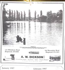
Souvenir - Complimentary A.W.Dickson Real Estate Agents calendars, Complimentary A.W.Dickson Real Estate Agents calendars - 1987 and 1988.1987 calendar with photographic images of local Ringwood features and 1988 calendar featuring local Ringwood land sale promotional images from early 20th Century
... Ringwood features and 1988 calendar featuring local Ringwood land... Ringwood features and 1988 calendar featuring local Ringwood land ...A.W.Dickson was a Real Estate Agent in Ringwood for many years. These calendars show the local buildings of the day. For example the original Eastland 's building of 1967, Maroondah Hospital 1976 and the Civic Centre now the Karralyka Centre.1 1987 calendar with six black and white photos of buildings and vistas around Ringwood with monthly dates in lower quarter of page. 2 1988 calendar with six posters advertising early 20th century land sales in Ringwood, Heathmont and Ringwood East with dates in lower quarter of page Compiled by A.W.Dickson Pty. Ltd. Real Estate Agent. Photographed by C.M.S. Photographers - 725 9441 (January February 1987) RINGWOOD LAKE - Ideal picnic spot for Ringwood Model power boats frequently on display. Barbecue area, playground, resting place for old steam engine. Yabbie netting is a favourite pastime here. (March April 1987) CLOCK TOWER - Moved from its former site on Warrandyte Road corner in 1967 and re-built in its present location, brick by brick. A wreath laying ceremony is held here on Anzac day each year. (May June 1987) RINGWOOD AQUATIC CENTRE - A world class swimming facility opened in 1986 at a cost of $3 million. Featuring the latest ozone water treatment techniques. In summer folding doors can be opened to give access to existing outdoor pools and sunbathing area. (July August 1987) MAROONDAH HOSPITAL - Opened in 1976 after many years of fund raising efforts by local people. The opening of casualty facilities was welcomed by locals as previously Box Hill Hospital catered for the entre area. (September October 1987) EASTLAND - Opened October 1967. Built on a former football oval. Now about to undergo major extensions to cater for Ringwood's population growth into the 21st Century. November December 1987 CIVIC CENTRE - Built on the site of a former antimony mine behind the council offices. Now the venue for many activities and a local point for Ringwood's Cultural Life. -
 Warrnambool and District Historical Society Inc.
Legal record - Two documents regarding purchase and sale of land, George Barber, Port Fairy solicitor, early 1850s
... Two documents regarding purchase and sale of land...Thes two documents deal with the purchase and sale of land...Two documents regarding purchase and sale of land Legal ...Thes two documents deal with the purchase and sale of land near Warrnambool by Thomas Simpson. The first document, called a Grant by Purchase, is dated 1852 and shows that Thomas Simpson purchased from the Crown, Allotment 146 (22 acres two roods) adjoining the property of Wollaston on the Merri River and the Mortlake Road, north of Warrnambool. The cost was 90 pounds. The second document is dated 1853 and shows that Thomas Simpson sold this Merri River allotment of 22 acres to Eliza Bromfield, in conjunction with her husband, John Davenport Bromfield, for the sum of 110 pounds. The property of Wollaston was owned by the Manifold family and in the 1850s was leased to William Simpson, the brother of Thomas who had an adjoining property called Wooramoota. John Davenport Bromfield was a Colac farmer who played a prominent part in the early history of that town. His brother James Astley Bromfield, an early chemist in Warrnambool is important in Warrnambool's history.These two items are of considerable significance because they are amongst the earliest legal documents we have connected to Warrnambool's history and because they concern three early pioneers of the district. They also have a connection to Wollaston, an important early property in the Warrnambool district..1 A piece of light parchment paper, stained with age and folded in three places. It contains printed and handwritten material, a copy of a signature and a white seal. .2 A piece of parchment paper folded in half and then folded again in two places. It contains ruled red lines, handwritten material in black ink and the remains of a red seal. The top of the first page has a cut-out fluted pattern.wollaston, john davenport bromfield, thomas simpson, eliza bromfield, george barber solicitor -
 Flagstaff Hill Maritime Museum and Village
Journal - Women's Journal, Curtis Publication Company, The Ladies' Home Journal 1891-95, ca. 1891
This is one of two books donated together and believed to have belonged to the Purvis family. The books were rescued from recycling. It has the name of C Purvis on the front endpaper. The other book from the same donor has the inscription "C. A. Purvis". The inscription on the back endpaper of the other book belonging to C. Purvis is of interest, '"Edith Fox, Gheringhap, 1879"' as it is earlier than the earliest journal in that book. Perhaps it is the birth date of Edith. It is also interesting that an notice was printed in the Geelong Advertiser in 1922 stating that Edith Susan Fox of Box Hill had an interest in land in Gheringhap. Gheringhap is a town on the Midland Highway, Victoria, 15 km northwest of Geelong, and 6.7 km southeast of Bannockburn.This is one of two journals of ladies' fashion, fancy work and stories that reflect the interests of the late 1800s. They are a useful source of historical information and the articles available for sale.The Ladies' Home Journal 1891- 95; a collection of women's journals in a burgundy hardcover book with a leather-bound spine and leather-reinforced corners. The journals are illustrated magazines and include fashion, fancy work and family reading, Published in Philadelphia, America by the Curtis Publishing Company. The binder was made by G Mercer, Geelong. A printed blue label is on the inside front cover. An inscription is on the corner of the front fly page.On spine: "THE LADIES' HOME JOURNAL" Within two concentric oval outlines "G. MERCER / GEELONG" and it nthe centre "BINDER" Handwritten in black pen and crossed out "E. F." Handwritten in blue pen "C. Purvis"flagstaff hill, flagstaff hill maritime museum and village, warrnambool, maritime museum, maritime village, great ocean road, shipwreck coast, young ladies journal, ladies journal, women's journal, edith fox, gheringhap, fashion, fancy work, family reading, illustrated magazine, curtis publishing company, philadelphia, young ladies journal 1891-95, 1891-1895, purvis, g. mercer of geelong, stationery -
 Federation University Historical Collection
Booklet - Booklet - Prospectus, Bairnsdale District School of Mines, Prospectus, 1904
Higher education in east Gippsland dates back to 1890, and the opening of the Bairnsdale District School of Mines, In 1986 the Bairnsdale School of Mines and the Sale and Bairnsdale Technical schools amalgamated to form the East Gippsland Community College of TAFE. In 1995 it became the East Gippsland Institute of Technology, and in 2011 changed its name to Advance TAFE. The Bairnsdale District School of Mines Prospectus includes the members of council, a photographic image of the school, teaching staff, rules relating to students and instructors, Constitution, and a prospectus of subjects including Mining and Science Subjects, Diploma Courses, Preliminary Training, Metallurgy Course, Mining Engineering Course, Battery Manager's Certificate, Assayer's Certificate. It also includes a scale of fees, information on the Metallurgical Plant, Chemistry, Assaying and Metallurgy, Geology, Mining Geology, Mining, Petrology, Dynamics and Heat, Magnetism & Electricity, Mechanics Applied to Mining, Land Surveying, Mine Surveying, Algebra, Euclid, Trigonometry, Mechanical Drawing, Practical Plane Geometry, Practical Solid Geometry, Engineering Drawing, Art Subjects, and a list of certificates issued by the school since 1892.Grey soft covered book of 68 pages. The Bairsndale District School of Mines Prospectus includes the members of council, an photographic image of the school, teaching staff, rules relating to students and instructors, Constitution, and a prospectus of subjects including Mining and Science Subjects, Diploma Courses, Preliminary Training, Metallurgy Course, Mining Engineering Course, Battery Manager's Certificate, Assayer's Certificate. It also includes a scale of fees, information on the Metallurgical Plant and its chares, Chemistry, Assaying and Metallurgy, Geology, Mining Geology, Mining, Petrology, Dynamics and Heat, Magnetism & Electricity, Mechanics Applied to Mining, Land Surveying, Mine Surveying, Algebra, Euclid, Trigonometry, Mechanical Drawing, Practical Plane Geometry, Practical Solid Geometry, Engineering Drawing, Art Subjects, and a list of certificates issued by the school since 1892.bairnsdale district school of mines, bairnsdale, school of mines, donald clark, francis w. sewell, j.v.r. anderson, a.d. pleydell, walter seehusen, director, mining engineering, metallurgy, academy of arts, municipal surveyor, 1914 -
Glenelg Shire Council Cultural Collection
Administrative record - Deed of Sale, 1853
hurd street portland -
 Bayside Gallery - Bayside City Council Art & Heritage Collection
Photograph, Department of Crown Lands and Survey, Victoria, Brighton, Brighton East and Bentleigh, c. 1965-71
The Department of Crown Lands and Survey (1857-1983) was responsible for the administration of survey and mapping and the sale, occupation and management of crown land throughout its existence. This aerial photograph shows parts of Brighton and Brighton East and was taken circa 1965-71.brighton, department of crown lands and survey, aerial photograph, bayside, port phillip bay, map, cartographic material, brighton east, dendy park, dendy street, centre road, nepean highway, south road, brighton golf course, golf -
 Bayside Gallery - Bayside City Council Art & Heritage Collection
Photograph, Department of Crown Lands and Survey, Victoria, Brighton, Brighton East and Bentleigh, c. 1965-71
The Department of Crown Lands and Survey (1857-1983) was responsible for the administration of survey and mapping and the sale, occupation and management of crown land throughout its existence. This aerial photograph shows parts of Brighton, Brighton East and Bentleigh and was taken circa 1965-71.brighton, department of crown lands and survey, aerial photograph, bayside, port phillip bay, map, cartographic material, bentleigh, brighton east, dendy park, dendy street, centre road, nepean highway, south road, football -
 Bayside Gallery - Bayside City Council Art & Heritage Collection
Photograph, Department of Crown Lands and Survey, Victoria, Brighton, Elwood and Elsternwick, c. 1965-71
The Department of Crown Lands and Survey (1857-1983) was responsible for the administration of survey and mapping and the sale, occupation and management of crown land throughout its existence. This aerial photograph shows parts of Brighton, Elwood and Elsternwick and was taken circa 1965-71.brighton, department of crown lands and survey, aerial photograph, bayside, port phillip bay, map, cartographic material, elwood, elsternwick, elsternwick park, elwood tram depot, elwood pier, new street, glen huntly road, st kilda street, nepean highway -
 Bayside Gallery - Bayside City Council Art & Heritage Collection
Photograph, Department of Crown Lands and Survey, Victoria, Melbourne Project: Brighton and Elwood, 1976
The Department of Crown Lands and Survey (1857-1983) was responsible for the administration of survey and mapping and the sale, occupation and management of crown land throughout its existence. This aerial photograph shows parts of Brighton and Elwood and was taken on 1 December 1976brighton, elwood, department of crown lands and survey, aerial photograph, elsternwick park, point ormond, north road, ormond esplanade, st kilda street, glen huntly road, bayside, port phillip bay, map, cartographic material, melbourne project 1976 -
 Bayside Gallery - Bayside City Council Art & Heritage Collection
Photograph, Department of Crown Lands and Survey, Victoria, Melbourne Project: Brighton, Hampton, Sandringham, 1976
The Department of Crown Lands and Survey (1857-1983) was responsible for the administration of survey and mapping and the sale, occupation and management of crown land throughout its existence. This aerial photograph shows parts of Brighton, Hampton and Sandringham and was taken on 1 December 1976brighton, department of crown lands and survey, aerial photograph, bayside, port phillip bay, map, cartographic material, hampton, sandringham, green point, sandringham yacht club, south road, beach road, hampton street, melbourne project 1976 -
 Bayside Gallery - Bayside City Council Art & Heritage Collection
Photograph, Department of Crown Lands and Survey, Victoria, Melbourne Project: Brighton, 1976
The Department of Crown Lands and Survey (1857-1983) was responsible for the administration of survey and mapping and the sale, occupation and management of crown land throughout its existence. This aerial photograph shows parts of Brighton and was taken on 1 December 1976brighton, department of crown lands and survey, aerial photograph, bayside, port phillip bay, map, cartographic material, melbourne project 1976, brighton yacht club, middle brighton baths, north road, st kilda street, new street -
 Bayside Gallery - Bayside City Council Art & Heritage Collection
Photograph, Department of Crown Lands and Survey, Victoria, Melbourne Project: Brighton and Hampton, 1976
The Department of Crown Lands and Survey (1857-1983) was responsible for the administration of survey and mapping and the sale, occupation and management of crown land throughout its existence. This aerial photograph shows parts of Brighton and Hampton and was taken on 1 December 1976. brighton, department of crown lands and survey, aerial photograph, bayside, port phillip bay, map, cartographic material, melbourne project 1976, brighton yacht club, middle brighton baths, hampton, green point, brighton beach, south road, the esplanade, hampton street -
 Kew Historical Society Inc
Plan - Subdivision Plan, Kew Golf Links Estate, 1936
The Kew Golf Links Estate was a major subdivision in North Kew. It derived its title due to the land being previously occupied by the Kew Golf Club, which transferred its course to a number of locations before occupying its current site. The Plan advertises 180 choice home sites. The street names are somewhat different today as those on the map are named after the proposed Kodak Factory to be built on the site. The subdivision of the Kew Golf Links Estate was a major subdivision of farmland in Kew. The site was at one stage designated for industrial development and the building of a new Kodak factory. The decision by Council to oppose the redevelopment makes the beginning of the period when all industrial development was banned in Kew.Monochrome printed, folded subdivision plan for the Kew Golf Links Estate, to be auctioned on 7 November 1936. Streets named include: Carnegie Avenue, Willsmere Road, Kilby Boulevarde, Kodak Avenue, Coleman Avenue, Beresford Avenue, McConchie Avenue, Cole Avenue, White Avenue, Baker Avenue, Spruzen Avenue, Tanner Avenue, Ratten Avenue, Mathers Avenue, Railway Avenue, Sutherland Avenue, and Belford Road. The position of the Yarra River and a large Drainage Reserve are marked on the plan. Lots for sale are numbered. Existing buildings are designated with a square.subdivision plans - kew (vic), kodak factory - kew (vic)