Showing 14764 items
matching north road
-
 Whitehorse Historical Society Inc.
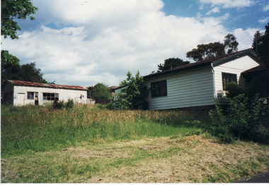
Photograph, Schwerkolt House, 1/11/1999 12:00:00 AM
... for Francesca Schwerkolt, C.1960's, Deep Creek Road, Mitcham. North... Schwerkolt, C.1960's, Deep Creek Road, Mitcham. North elevation ...Weatherboard Home, painted cream and green, built for Francesca Schwerkolt, C.1960's, Deep Creek Road, Mitcham. North elevation showing outbuilding.schwerkolt, francesca, deep creek road, mitcham -
 Bendigo Historical Society Inc.
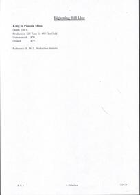
Document - MINING REPORTS - KING OF PRUSSIA MINE
... KING OF PRUSSIA MINE WHIPSTICK ROAD EAGLEHAWK NORTH...KING OF PRUSSIA MINE WHIPSTICK ROAD EAGLEHAWK NORTH ...KING OF PRUSSIA MINE WHIPSTICK ROAD EAGLEHAWK NORTH, GREATER BENDIGO CITY Place ID 8444 Location WHIPSTICK ROAD EAGLEHAWK NORTH, GREATER BENDIGO CITY Municipality GREATER BENDIGO CITY Heritage Listing Victorian Heritage Inventory Level of significance Heritage Inventory Site Heritage Inventory (HI) Number H7724-0141Brief handwritten notes by Albert Richardson, with typed copy of same, on the King of Prussia Mine on the Lightning Hill Line. Notes give the depth, crushings, gold yield, commenced 1876 and closed 1877.gold, mining reports, mining reports, kinf of prussia mine, b m l production statistics -
 Bayside Gallery - Bayside City Council Art & Heritage Collection
Map, Department of Crown Lands and Survey et al, Moorabbin, County of Bourke, Government Roads, 1920
... extends to North Road, Brighton at top. The letter is typed... to North Road, Brighton at top. The letter is typed in black ink ...The cadastral map of the Parish of Moorabbin in Victoria (L.6104) shows parish boundaries and land ownership 1920 when Sandringham was a Town. The government roads have been coloured in red pencil.moorabbin, county of bourke, map, plan, land subdivision, land titles, foreshores, hampton, beaumaris, highett, cheltenham, department of lands and survey, land owners, cartographic material, brighton, sandringham, town of sandringham, government roads -
 Melbourne Tram Museum
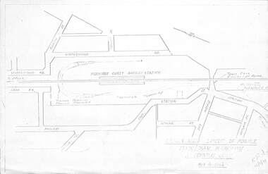
Drawing, Melbourne & Metropolitan Tramways Board (MMTB), "Modal Interchange Huntingdale Railway Station", 1973
... Gully" - dated 16/11/1973 Shows North Road, railway line... interchange at Ferntree Gully" - dated 16/11/1973 Shows North Road ...Set of four foolscap and folded sheets illustrating model interchange at the Ferntree Gully Railway station to serve Monash University and further west. .1 - Photocopy of a sketch titled "Approximate layout of possible train tram interchange at Ferntree Gully" - dated 16/11/1973 Shows North Road, railway line, railway station and possible tram line. .2 - P14532 - sketch of a schematic layout at Huntingdale showing trains at either platform face along with a tram. Dated 11-12-1973. Has figure 10 along the bottom edge. .3 - P14536 - dated Dec. 1973, showing a possible route to Modal Interchange at Ferntree Gully railway station using Forest Road. .4 - P14537 - ditto, but using Station St. See Reg Item 3806 for sketches at the Huntingdale Railway Station and Monash University.trams, tramways, ferntree gully, new tramway, railways, wellington rd, monash university -
 Glenelg Shire Council Cultural Collection
Postcard - Postcard - Portland Lighthouse, c. 1950
... & three children walking on an unsealed road north of Whaler's... road north of Whaler's Bluff. Clothing suggests c. 1950's-60's ...Postcard showing lighthouse & Harbour, Portland, Victoria, from the "Rose" series ----colourview No 503, showing adult & three children walking on an unsealed road north of Whaler's Bluff. Clothing suggests c. 1950's-60'spostcard, view of portland, holiday, whalers bluff, lighthouse -
 Hume City Civic Collection
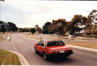
Photograph, Late 1990's
... the north side ofRiddell Road and the football ground... the north side ofRiddell Road and the football ground ...Riddell Road is the continuation of Macedon Street and is on the west side of the town centre. It is the main road to Riddells Creek, the Sunbury airstrip, Sunbury tip and water towers.A coloured photograph of Riddell Road looking west. A red car is in the foreground travelling north and is at the T intersection of Riddell Road and Ligar Street. There are houses along the north side of Riddell Road and the football ground is on the south side of the road.sunbury football club, riddell road, ligar street, george evans collection -
 Eltham District Historical Society Inc
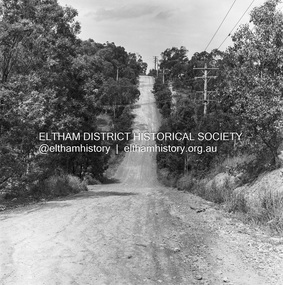
Photograph, Michael Wood, Progress Road looking east from Scenic Crescent, Eltham, 1976, 1976
... eltham north, scenic crescent, progress road, road...Progress Road between Ryans Road and Lower Road, Eltham...Progress Road, Eltham North, Victoria... melbourne Progress Road between Ryans Road and Lower Road, Eltham ...Progress Road between Ryans Road and Lower Road, Eltham North; prior to realignment and construction, 1976Kodak Safety Film 120 format 6 x 6 cm black and white negative; 3 strips, 12 frames Also 30 x 25 cm black and white print of this image frameeltham north, scenic crescent, progress road, road construction -
Whitehorse Historical Society Inc.
Newspaper - Article, Historic homestead, 1/03/2000
... at 17-21 Junction Road, Blackburn North, for auction on 11 March... Mitcham melbourne Junction Road Blackburn North No 17 - 21. Argyle ...Property advertisement for 3 bedroom Edwardian timber house at 17-21 Junction Road, Blackburn North, for auction on 11 March 2000. Agent: Argyle Partners.junction road, blackburn north, no 17 - 21., argyle partners, auctions -
Whitehorse Historical Society Inc.
Article, A Grand way to live, 2007
... The house at 48 Shafer Road, Blackburn North is Edwardian... daughter Isobella Blanche Hollonds Shafer Road Blackburn North ...The house at 48 Shafer Road, Blackburn North is Edwardian and once boasted a substantial orchard.The house at 48 Shafer Road, Blackburn North is Edwardian and once boasted a substantial orchard. It was built in 1903 by Victor Lawford for his daughter Isobella Blanche HollondsThe house at 48 Shafer Road, Blackburn North is Edwardian and once boasted a substantial orchard. shafer road, blackburn north, no. 48, hollonds, isobella blanche, lawford, victor -
 Kew Historical Society Inc
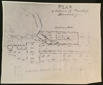
Print - Subdivision Plan (copy), Plan of Section 79 Parish of Boroondara (Clifton Estate), Nineteenth Century
... represent the first land sales in Kew in the area north of Studley... in the area north of Studley Park Road. Plan of Section 79 Parish ...This work forms part of the collection assembled by the historian Dorothy Rogers, that was donated to the Kew Historical Society by her son John Rogers in 2015. The manuscripts, photographs, maps, and documents were sourced by her from both family and local collections or produced as references for her print publications. Many were directly used by Rogers in writing ‘Lovely Old Homes of Kew’ (1961) and 'A History of Kew' (1973), or the numerous articles on local history that she produced for suburban newspapers. Most of the photographs in the collection include detailed annotations in her hand. The Rogers Collection provides a comprehensive insight into the working habits of a historian in the 1960s and 1970s. Together it forms the largest privately-donated collection within the archives of the Kew Historical Society.A photographic reproduction of a plan in the Vale Collection of the State Library of Victoria. The numbered lots represent the first land sales in Kew in the area north of Studley Park Road.maps (kew), plan of section 79 parish of boroondara -
Canterbury History Group
Photograph - J. Weymouth , Ironmonger, c1910
... J. Weymouth Ironmonger, north side of Canterbury Road...Canterbury Canterbury Road J. Weymouth Ironmonger Railway ...J. Weymouth Ironmonger, north side of Canterbury Road. Unsealed road and gutters, horse and cart in front of shop and closed railway gates black and white photographcanterbury, canterbury road, j. weymouth ironmonger, railway crossings, horse drawn vehicles -
 Melbourne Tram Museum
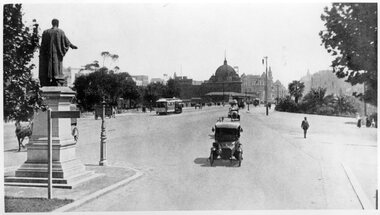
Photograph - Black and White - St Kilda Road near City Road
... Road near City Road looking north - with Edmund FitzGibbon... Photo 1 - looking north from the point where St Kilda Road ...Photo 1 - looking north from the point where St Kilda Road widened after crossing Princes Bridge. Has the Edmund Fitzgibbon monument on the left. One cable tram set is making its way into the City. Has Flinders St Station in the background, along with a number of motor cars and one horse drawn vehicle behind the monument and another behind a sign. In the far distance is an advertisement for The Herald newspaper. Photo 1910c Photo 2 - looking south from near the end of the bridge, with seven cable cars in the view, along with motors cars and two horse drawn vehicles. Government House can be seen on the left horizon.Yields information about St Kilda Road c1910.Set of two black and white photographs of" .1 - St Kilda Road near City Road looking north - with Edmund FitzGibbon monument .2 - looking southtramways, trams, cable cars, flinders street station, st kilda road, princes bridge, monuments, edmund fitzgibbon -
 Ringwood and District Historical Society
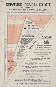
Flyer, Land Auction Sale Advertisement - Ringwood Heights Estate, Ringwood, Victoria - circa 1923
... Warrandyte and Wonga Roads, North Ringwood, with terms of sale... Road Ringwood North melbourne Subdivision includes Wonga Road ...Advertisement for land and weatherboard villa auction sale on Saturday, January 13 (1923?) - Ringwood Heights Estate, corner Warrandyte and Wonga Roads, North Ringwood, with terms of sale, summary of local features and services, and map showing layout of subdivisionSubdivision includes Wonga Road and Anderson's Creek Road (later Warrandyte Road). Agents - Sydney T. Haynes & Co., Auctioneers, 60 Queen Street, Melbourne. Phone Central 3400; J.B. McAlpin, Estate Agent, Opposite Ringwood Station. Auction in the Trust Estate of J.J. Parker, instructed by the Equity Trustees Co. Ltd. 85 Queen Street, Melbourne. -
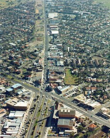 City of Kingston
Photograph - Colour, c. 1982
... north towards Cummins Road.... north towards Cummins Road. Photograph Colour ...This aerial photograph of South Road and Nepean Highway, Moorabbin shows the area where houses and shops on the south side of the Nepean Highway have demolished for the widening of the highway. The pressures of rapid urban development in Moorabbin and beyond, especially to the south of Moorabbin caused bottlenecks and delays, especially at the South Road and Nepean Highway intersection, hence the scheme to widen Nepean Highway.The pressures of rapid urban development in terms of people, housing construction, industrial development and commercial activity, in Moorabbin and beyond, especially to the south would put pressure on road infrastructure in the region. In the early 1980s, a major road expansion of the Nepean Highway was implemented to increase capacity on this major thoroughfare for vehicle commuters. Car use had also increased with commuters from the increasingly populous southern suburbs travelling to their place of work in the Melbourne CBD.Colour photograph of an aerial view of South Road and Nepean Highway, Moorabbin. The image shows houses on the south side of the Nepean Highway that have demolished for widening of road. It features housing and commercial buildings looking north towards Cummins Road.Handwritten blue ink: 82 - 5452 - 11 Handwritten red ink: 112% Handwritten black ink: Ch. 7nepean highway, south road, moorabbin, roads, transport, infrastructure -
 Whitehorse Historical Society Inc.
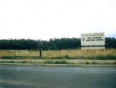
Photograph, Old Orchard Shopping Centre Blackburn Road, 17/11/2010 12:00:00 AM
... of Springfield and Williams Road, Blackburn North, was opened in October... on the corner of Springfield and Williams Road, Blackburn North ...The Old Orchard Shopping Centre, situated on the corner of Springfield and Williams Road, Blackburn North, was opened in October 1965.Coloured photograph of the land on which the Old Orchard Shopping Centre was built. Sign on right 'Old Orchard Shopping Centre - A Lend Lease development.'old orchard shopping centre, blackburn, shopping centres -
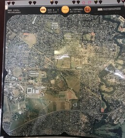
 Eltham District Historical Society Inc
Photograph - Aerial Photograph, Landata, Eltham, Feb. 1956
... by Leane Drive and Parsons Road to north, Nyora Road to south... by Leane Drive and Parsons Road to north, Nyora Road to south ...Centred on present day Shalbury Avenue, Eltham bounded by Leane Drive and Parsons Road to north, Nyora Road to south, Reynolds Road to east and the Diamond Creek to west Historic Aerial Imagery Source: Landata.vic.gov.au Aerial Photo Details: Project No :250 Project : MELBOURNE OUTER SUBURBS PROJECT Run : 18 Frame : 95 Date : 02/1956 Film Type : B/W Camera : EAG9 Flying Height : 10000 Scale : 12000 Film Number : 1176 GDA2020 : 37°41'57"S, 145°09'51"E MGA2020 : 338145, 5825965 (55) Melways : 22 C1 (ed. 42)aerial photo, 1956-02, neil webster collection, eltham, diamond creek (creek), melway 22c1, nyora road, parsons road, reynolds road, shalbury avenue -
 Glen Eira Historical Society
Photograph - Glenhuntly Road, Glen Huntly
... Huntly Road, north side west of the railway line. The photographs... block on Glen Huntly Road, north side west of the railway line ...Two colour photographs of a public toilet block on Glen Huntly Road, north side west of the railway line. The photographs may date to the 1980s though the exact dates are unknown. Photographer unknown.glen huntly road, glenhuntly, glenhuntly road, glen huntly, toilets, public conveniences -
 Sunshine and District Historical Society Incorporated
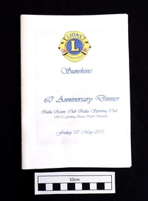
Booklet (2013), LIONS CLUB of SUNSHINE 60th Anniversary Dinner, 10 May 2013, 2013
... / Italia Room, Club Italia Sporting Club 128-152 Furlong Road... Furlong Road, North Sunshine / Friday 10th May 2013 White paper ...On 12th May 1953 a meeting was arranged by the Lions Club of Footscray, and was held at the home of Bill Harvey in Sunshine, with the intention of forming a club in the Sunshine area. The first official luncheon was held on 3rd June 1953 at the Sunshine Town Hall and was attended by representatives from Melbourne, Footscray and Essendon Clubs. After the membership reached 25 the Lions Club of Sunshine was Chartered on 21st July 1953, and became the 5th Club in Victoria and the 17th in Australia. Over the years the club raised funds through various activities to provide charitable donations to organisations, people, and disaster areas, as well as to purchase house and land for a Senior Citizens Club. It became necessary to sell the house and land years later. The Lions Club also contributed to the Sunshine Swimming Pool which was opened in December 1960, and was welcomed by the children of Sunshine. Some of the activities to raise funds included Guy Fawkes bonfire nights, rodeos, paper and bottle drives, jumble sales,Tivoli Gala Nights, car raffles, and sausage sizzles. Over the past 10 years the Sunshine Lions have put in thousands of hours of work, and have disbursed in excess of $200,000 for charitable purposes. As well as supporting overseas projects and natural disasters, the Lions have continued their community work. Funds have been donated to care providers such as the Mercy Hospice and Scope, and also used to provide Christmas hampers and dinners, and for underprivileged children to have holidays. Some of the organisations that have recently received funds were Helping Hands Across the Pacific, Gellibrand Services, Royal District Nursing Service, and the Sunshine Mission. During 1960/61 the club membership reached a record 58, however at the time of the 60th Anniversary dinner the membership was 17, three of which were in their seventies and 3 in their eighties. The above brief historical information was sourced from the 60th Anniversary Dinner booklet.This booklet is significant because it contains an 11 page summarised historical record of the 60 years of activities of the Lions Club of Sunshine. It also contains an Honour Roll of past members and of members who received awards, as well as the names of the 61 people who served as Club Presidents from W.T. Harvey (1953-54) to P. Green (2012-13). The booklet can be used as a starting reference source for anybody seeking information about the Lions Club of Sunshine Inc.White paper booklet of 20 pages with blue printing and a blue and yellow Lions International emblem on the front cover. The booklet contains the dinner Menu and the Programme for the evening, as well as a summary of the 60 years of activities of the LIONS CLUB of SUNSHINE. It also features the names of the 61 Club Presidents, the members who received awards, and an Honour Roll.LIONS L INTERNATIONAL / Sunshine / 60th Anniversary Dinner / Italia Room, Club Italia Sporting Club 128-152 Furlong Road, North Sunshine / Friday 10th May 2013lions club of sunshine, 60th anniversary dinner, lions sunshine presidents 1953-2013, lions sunshine honour roll, historical activities of lions sunshine -
Linton Mechanics Institute and Free Library Collection
Book - Novel, Tyler, Clarke, Showdown at Singing Sands : a Clint Lacey western, 1956
... : "Roundabout Book Club, Kooyong Road, North Caulfield"; "W. L. & G...: "Roundabout Book Club, Kooyong Road, North Caulfield"; "W. L. & G ...Western adventure fiction160 p. :red cover, section of original dust jacket pasted to front cover, image depicts two men engaged in a gun fight. Summary of plot cut from dust jacket pasted to front end paper.fictionWestern adventure fictionfiction, westerns, clarke tyler -
 Eltham District Historical Society Inc
Photograph - Digital Photograph, Alan King, Ore crusher, Golden King mine, Yarrambat, 22 January 2008
... or Reynold's Corner after Frederick Tanck who owned land north... or Reynold's Corner after Frederick Tanck who owned land north ...Prior to 1929 Yarrambat was known as Tanck's Corner or Reynold's Corner after Frederick Tanck who owned land north of Ironbark Road at the corner of Yan Yean Road, and Thomas Ryenolds who owned the property opposite. Tanck's Corner was at the centre of gold bearing country. Gold was mined here until 1984 when the last operating mine, the Golden King mine in North Oatlands Road closed. It was owned by the Clayton family and in the 1960s was the only private family gold mine in Victoria. Larger mines had their own batteries and stampers to process the ore. Covered under Heritage Overlay, Nillumbik Planning Scheme. Published: Nillumbik Now and Then / Marguerite Marshall 2008; photographs Alan King with Marguerite Marshall.; p23This collection of almost 130 photos about places and people within the Shire of Nillumbik, an urban and rural municipality in Melbourne's north, contributes to an understanding of the history of the Shire. Published in 2008 immediately prior to the Black Saturday bushfires of February 7, 2009, it documents sites that were impacted, and in some cases destroyed by the fires. It includes photographs taken especially for the publication, creating a unique time capsule representing the Shire in the early 21st century. It remains the most recent comprehenesive publication devoted to the Shire's history connecting local residents to the past. nillumbik now and then (marshall-king) collection, battery, clayton family, gold mining, golden king mine, ore crusher, tancks corner. reynolds corner, yarrambat -
 Eltham District Historical Society Inc
Photograph, Thompson Crescent area, Research
... Crescent North 2. Reynolds Road/Thompson Crescent South 3. Reynolds.... Reynolds Road looking south from Thompson Crescent North 2 ...Three colour photographs of roads in the Thompson Crescent area, Research 1. Reynolds Road looking south from Thompson Crescent North 2. Reynolds Road/Thompson Crescent South 3. Reynolds Road/Thompson Crescent North, Researchthompson crescent, reynolds road, research -
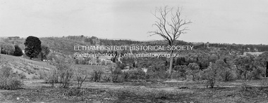 Eltham District Historical Society Inc
Photograph, Barry Philp, Looking north from the top of the hill near Reynolds Road, Research, c.1969
... Taken from the top of the hill near Reynolds road looking... melbourne Taken from the top of the hill near Reynolds road looking ...Taken from the top of the hill near Reynolds road looking north. The footy ground is visible behind the dead tree.research (vic.), research oval, reynolds road -
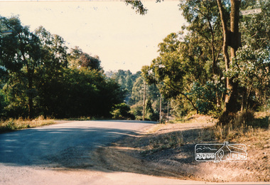
 Eltham District Historical Society Inc
Photograph, Eucalyptus Road and Pitt Street/Nyora Road roundabout, Eltham
... Looking north along Eucalyptus Road, showing roundabout... melbourne Looking north along Eucalyptus Road, showing roundabout ...Looking north along Eucalyptus Road, showing roundabout at intersection of Pitt Street and Nyora Road, Eltham. Parks Victoria owns and manages the Pauline Toner Eltham Copper Butterfly Reserve on the left of the image. Colour photographeucalyptus road, pitt street, nyora road, roundabouts, eltham, pauline toner eltham copper butterfly reserve, pauline toner butterfly nature conservation reserve -
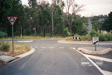 Eltham District Historical Society Inc
Photograph, Eucalyptus Road and Pitt Street/Nyora Road roundabout, Eltham
... Looking north along Eucalyptus Road, showing roundabout... melbourne Looking north along Eucalyptus Road, showing roundabout ...Looking north along Eucalyptus Road, showing roundabout at intersection of Pitt Street and Nyora Road, Eltham. Parks Victoria owns and manages the Pauline Toner Eltham Copper Butterfly Reserve on the left of the image.Roll of 35mm colour negative film, 4 stripsFuji 100eltham, eucalyptus road, nyora road, pitt street, roundabouts, pauline toner eltham copper butterfly reserve, pauline toner buttefly nature conservation reserve -
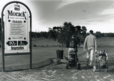 Whitehorse Historical Society Inc.
Photograph, Morack Public Golf Course, 1994
... , 1976. Comprising a 9-hole course it was sited north of Burwood...Whitehorse Historical Society Inc. 2-10 Deep Creek Road ...Morak Golf Course opened to the public on Sat. 8th May, 1976. Comprising a 9-hole course it was sited north of Burwood Road (now Burwood Highway) and between Morak Road and the Dandenong Creek.Black and white photograph of the Morak Public Golf Course, Vermont South. Large sign on left and two golfers heading out on right. 1994morack golf course -
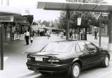 Whitehorse Historical Society Inc.
Photograph, Mitcham Mall, 5/01/2001 12:00:00 AM
... North. Taken from Whitehorse Road looking along Brittania... of Mitcham Mall, Mitcham, looking North. Taken from Whitehorse Road ...Black and white photo of Mitcham Mall, Mitcham, looking North. Taken from Whitehorse Road looking along Brittania Street towards Multi Storey Car Park.britannia mall mitcham -
 City of Moorabbin Historical Society (Operating the Box Cottage Museum)
Document, laminated photocopy of 'Plan of Moorabbin 1850', 1853
... North Road to South Road in the Parish of Bourke Victoria... Phillip Bay to East Boundary Road and from North Road to South ...Weston Bate, 'A history of Brighton' 1962 informs us that in 1840 Henry Dendy, who was a farmer in Sussex England, paid 5,120 pounds sterling @ 1pound per acre for a 'Special Survey of Land in Port Phillip , Australia. Henry arrived in Australia in 1841 on the frigate 'York' with his wife, son, and three servants. He also took advantage of the Government Assistance of Free Immigrants for Survey Purchasers, to help on his estate and persuaded some Sussex men with their families to follow him. However when Dendy arrived in Port Phillip he found that LaTrobe and Gipps were trying to raise the price of land close to Town to 15pounds per acre. Dendy asked merchant J.B.Were to manage his affairs and they went ahead with plans to subdivide the surveyed land called 'The Brighton Estate' This area of land extended easterly from the Port Phillip Bay to East Boundary Road and from North Road to South Road in the Parish of Bourke Victoria. The Privy Council, England , decide that Henry Dendy could purchase the land at 1pound per acre. Land Sales proceeded from 1844 as more immigrants established market gardens, farms and varied businesses in 'Moorabbin'This is a photocopy of a Map of the Moorabbin , County of Bourke c1850 showing the 'Henry Dendy Special Survey 1841'A photocopy of a Map of the Moorabbin , County of Bourke c1850. A3 size laminatedLeft corner : MOORABBIN / COUNTY OF / BOURKEdendy henry, dendy special survey 1841, brighton, moorabbin, ormond, bentleigh, market gardeners, pioneers early settlers, box william, box elizabeth -
 Greensborough Historical Society
Aerial Photograph, AAM Photographics, Heidelberg AAM1969c 086, 24/11/1991
... , Macleod, Rosanna, Viewbank, Watsonia & Yallambie. North boundary... & Yallambie. North boundary Yallambie Road; West boundary Hurstbridge ...One of a series of four overlapping aerial photographs of the Heidelberg/Greensborough areas in 1991, covering Simpson Barracks, Macleod, Rosanna, Viewbank, Watsonia & Yallambie. North boundary Yallambie Road; West boundary Hurstbridge railway.Laminated colour aerial photographssimpson barracks, yallambie, watsonia, macleod, rosanna, viewbank -
 Eltham District Historical Society Inc
Photograph, Main Road, Research
... the Aqueduct 2. Looking north towards former road alignment 3. Looking... north towards former road alignment 3. Looking north towards ...Three colour photographs showing Main Road, Research in the vicinity of Research Industrial Estate. 1. Looking north towards the Aqueduct 2. Looking north towards former road alignment 3. Looking north towards the Little Eltham Theatre 3.main road, research, research industrial estate -
 Greensborough Historical Society
Photograph - Digital image, Noel Withers, Main Street Greensborough, looking North 2010, 04/06/2010
... View of Main Street Greensborough near Para Road, looking... near Para Road, looking North. Photograph taken by GHS member ...View of Main Street Greensborough near Para Road, looking North. Photograph taken by GHS member Noel Withers in 2010.Digital copy of colour photograph.main street greensborough, para road