Showing 20607 items matching "cape-town"
-
 Bendigo Historical Society Inc.
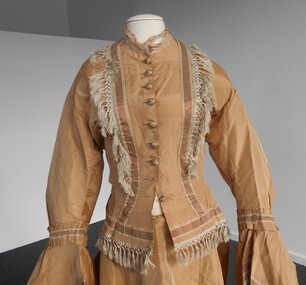
Clothing - GOLD SILK VICTORIAN CAPE (PART OF AN OUTFIT WITH 11400.975 AND 11400.977), Late 1900's
Three panels-one either side of front opening, and one rounded panel from side fronts, and across back. Two triangular panels - 10 cm X 4 cm at front lower edge of back circular panel. Front panels are longer than sides of back panels. All front and lower edges are finished with a 5 cm long, silver coloured, silk fringe. A 1.5 cm wide band of striped silk binds the neckline, nut is in very poor condition. Back panel of cape is gathered by hand, extending from front panel seams.costume, female, gold silk victorian bodice -
 Bendigo Historical Society Inc.
Book - VISION SPLENDID BENDIGO, 1986
Vision Splendid Bendigo. Cream coloured paper 56 pages, with line drawings of landmark buildings of Bendigo. Drawings by Jan Neil. Vision Splendid Introduction, Wesleyan Church Golden Square, Sacred Heart Cathedral, Central Deborah Mine, Marlborough House, Fuse factory, Goldmines Hotel, Fortuna Villa, Bon Accord, Heinz Butcher Shop, Long Gully State School, California Gully State School, Stone cottage Harvey Town, Eaglehawk Town Hall, Caradon, Eaglehawk State School, Victoria Hotel, Bendigo Pottery, Eucalyptus Distillery, St Luke’s, Lake Weeroona, Joss House, Benevolent Home, Lansellstowe, Kaithness, Malmo Valentine Street, Dudley House, Rifle Brigade Hotel, Fire Station, Masonic Hall, Temperance Hall, Old Post Office, Wesley Church, St. John’s Church, Alexandra Fountain, Commercial Bank View Point, State Bank, St Paul’s Cathedral Railway Station, National Bank, Town Hall, Post Office, Shamrock Hotel, Camp Hill State School, Police Barracks, Law Courts, Specimen Cottage, Technical College, St. Kilian’s Church, Tram Depot, St. Aidan’s OrphanageJan Neilbendigo, buildings, heritage buildings, heritage, heritage buildings, bendigo. -
 Christ Church Anglican Parish of Warrnambool
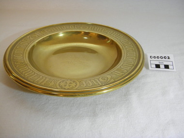
Plate, Untitled, Brass Alms dish, C.1902
Brass Collection Plate presented to St Paul's Anglican Church, Allansford, by the mother of Joseph & Frank Dallimore as a Memorial to the two brothers who drowned at Ryan's Den (near Cape Otway) on Jan 1st 1903. Major Joseph Dallimore (aged 32) was on leave from Sth Africa during the war and he, his wife (Beatrice Wiggs) and baby, his brother Frank Rupert Dallimore (aged 22), a farm hand Arthur Geach (aged 19) and a house maid servant, were picnicing at Ryan's Den (near Cape Otway) when the three men went walking, but never returned, all assumed drowned. One theary has it - Mrs M.E. Dallimore was picnicing at Lake Gillear beach when an enormous wave swept over the shore - (much larger than any other during that day) and rolled in all along the beach. This wave may have also reached the area where the three men were walking on the rocks and swept them into the ocean. Only one body was recovered - some 4 weeks later - that of Frank Rupert Dallimore and washed into Brown's Creek, 1 mile from the Johanna River and ten miles east of Ryans Den.It is a memorial plate and records the family's attachment and importance to the Church.Brass engraved and embossed Memorial Collection PlateEmbossed wording around edge of plate in Old English font reads - "All things come of Thee and of Thine own have we given Thee". The inscription on the tondo of the plate reads - "TO THE GLORY OF GOD / AND IN MEMORY OF / JOSEPH & FRANK RUPERT DALLIMORE, / WHO WERE DROWNED AT RYAN'S DEN, / JAN 1ST 1903. / PRESENTED BY THEIR LOVING MOTHER, / M.E.DALLIMORE."brass st pauls anglican church allansford warrnambool church of england christ church parish of warrnambool collection plate memorial plate dallimore drowning ryan s den alms dish -
 Flagstaff Hill Maritime Museum and Village
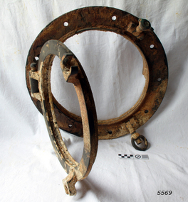
Functional object - Porthole frame, ca. 1889
This porthole and porthole cover was removed from the stern of the Newfield wreck, on the starboard side. The barque Newfield left Liverpool on 1st June 1892 with a cargo of 1850 tons of fine rock salt for Brisbane. About six weeks later the ship ran into very heavy weather approaching the Australian coast. On 28th August at about 9pm her master, Captain George Scott, observed between the heavy squalls the Cape Otway light on the mainland of Victoria, but due apparently to a navigational error (the chronometers were incorrect), he mistook it for Cape Wickham on King Island, some 40 miles south. He altered course to the north expecting to run through the western entrance of Bass Strait, but instead, at about 1:30am, the ship ran aground about about 100 yards from shore, one mile east of Curdies River. The vessel struck heavily three times before grounding on an inner shoal with six feet of water in the holds. The Newfield remained upright on the reef with sails set for a considerable time as the wind slowly ripped the canvas to shreds and the sea battered the hull to pieces. Seventeen men survived the shipwreck but the captain and eight of his crew perished.Flagstaff Hill’s collection of artefacts from the Newfield is significant for its association with the shipwreck Newfield, which is listed on the Victorian Heritage Registry. The collection is significant because of the relationship between the objects. The Newfield collection is archaeologically significant as the remains of an international cargo ship. The Newfield collection is historically significant for representing aspects of Victoria’s shipping history and its association with the shipwreckPorthole frame, including porthole and porthole cover, from the wreck of the Newfield. Porthole secured by nine bolts. It was removed from the stern of the wreck on the starboard side. there is some marine growth on the porthole. The cover still opens. warrnambool, shipwrecked coast, flagstaff hill, flagstaff hill maritime museum, maritime museum, shipwreck coast, flagstaff hill maritime village, shipwrecked artefact, 1892, 1893, 28 august 1892, 29 august 1892, barque, curdie's river, newfield, nineteenth century, peter ronald, peterborough, port campbell, porthole, porthole cover, shipwrecks, victorian shipwrecks, porthole frame -
 Warrnambool and District Historical Society Inc.
Booklet - Booklet Collection: City of Warrnambool Tourist Guides, Collett, Bain and Gaspar, Warrnambool
This is a collection of sixteen tourist guides dating from the mid 1970's to 2013. These contain listings of businesses, accommodation, eateries and events in Warrnambool and district. They also include maps of Warrnambool and surrounds, advertising and photographs of various attractions. While mainly covering Warrnambool a small number of the guides cover the South West Region. These directories have mainly been published by the Warrnambool City Council and are a selection of the types of information provided to visitors at the Tourist information centre during this time period.These tourist guides give snapshots of the City of Warrnambool for the years covered and will be useful for research.[.1] An 8 page paper booklet with black printing and a black & white photo of the pond at the Botanical Gardens on the front cover. [.2] two photocopied A4 black and white pages from the book "On the Trail" K Winser 1956 (Main Roads of Australia) [.3] A trifold colour brochure with a stylised map of the coast on the yellow and blue front cover. The inside has stylised colour drawings on Warrnambool attractions. The rear cover has coloured photographs of bush, Liebig Street and Fletcher Jones gardens [.4] A trifold black and white brochure with a black line drawing of a whale on the front cover. [.5] A trifold white card with mauve printing. The front cover has a line drawing of the former Timor Street post office and a map of businesses and landmarks in Timor Street. The reverse side contains a brief history of Warrnambool. [.6] A 98 page stapled booklet with a foreword by Vanda Savill. There are 4 pages of coloured photographs. The remainder are black and white photographs. The front cover is purple with white writing in the lower third. There is an outline of the coast and five colour photographs of district attractions. The inside middle page has a map of the Western wonderland region. The content covers towns in this area. Content relating to Warrnambool is in the last six pages. [.7] Twelve loose photocopied black and white pages. The front cover has the Warrnambool Premier Town 1988-1991 logo and a photo of a Southern Right Whale and calf. The bottom right hand corner has a Standard Warrnambool logo. [.8] 44 page booklet printed with blue ink. The staples have been removed. The glossy front cover has blue printing with a coloured photo of Flagstaff Hill Maritime Village pond. The centre pages has a fold out map of the City of Warrnambool. The rear cover has photos of The Twelve Apostles and Hopkins Falls. [.9] 4 loose photocopied pages with Warrnambool Library and Corangamite Regional Library Service Warrnambool City Library black ink stamps. The front page line drawing illustrations of Warrnambool attractions [.10] A single sheet of glossy white paper folded in half to make four pages. The front page has a Warrnambool premier town logo 1979-1982 and blue printing and a visitor survey. [.11] A conference pack of light card folded to make a pocket containing three brochures, a shipwreck coast tourist directory and a Australian Heritage Parks Association conference program dated 24 to 27 May 1992. The front cover of the pack has green writing over a stylised upward arrow. There is a City of Warrnambool logo in the top right hand corner and two film strips diagonally across the cover containing photographs of Warrnambool. The rear cover has a coloured Warrnambool Premier Town logo. [.12] A 63 page stapled booklet with coloured photographs of Warrnambool. The front cover has black writing on white background. There is a coloured photograph of Flagstaff Hill in the middle of the cover and a Warrnambool City and Visit Victoria logos on the lower edge. The middle pages has a coloured of the city of Warrnambool with an inset map of Allansford. [.13] A single large sheet of white paper folded in ten to make a brochure. The front cover has black printing. The rear cover has a purple ink stamp for the City of Warrnambool Tourist Information Centre. When folded out the reverse side has a green, grey and white map of the South West Region of Victoria. [.14] A 48 page colour booklet on glossy paper. The front cover has white writing on a blue background and includes photographs of the Twelve Apostles, the Promenade walk, Flagstaff Hill and a southern right whale's tail. The rear cover has photographs of The Twelve apostles, a passenger train from Melbourne passing the Lake Pertobe playground, and a rural scene. There is white writing and a white Warrnambool City logo on a blue background. The centre pages have a stylised green and blue map of the city of Warrnambool. [.15] A 48 page colour booklet on glossy paper. The front cover has white writing over colour photographs of two people at a lookout, Flagstaff Hill, three southern right whales and a child at the Lake Pertobe playground. The lower edge has blue upper case writing on a white background. The rear cover has a colour photograph of the Twelve Apostles. The lower white border on the rear covers has a a blue and green City of Warrnambool logo and blue writing. The centre pages have a stylised green and blue map of the city of Warrnambool. [.16] A 64 page colour booklet on glossy paper. The front cover has black writing on a black background and there is a photograph of a southern right whale's tail. The lower edge has the Warrnambool City and Visit Victoria Logos. The centre pages have maps of Warrnambool and surrounds. [.1] This week in Warrnambool Vol 2 No. 5 Thurs 1st Feb. For the time of your life [.2] Warrnambool Way [.3] Warrnambool The Holiday Host on the South West Coast with compliments City of Warrnambool and Warrnambool Chamber of Commerce [.4] MMI Insurance presents Whales Giants of the Deep Whale Watcher's Logbook Warrnambool [.5] Warrnambool History began in Timor Street [.6] Western Wonderland Tourist Association [.7] A Premier Arrow Tour of Warrnambool Victoria's Premier Town Australia's Southern Right Whale Nursery [.8] Warrnambool The Heart of Victoria's Great Southwest Visitor's Handbook [.9] What to see in Warrnambool Victoria's Premier City 1979-1982 [.10] Win a Free Holiday & $200 Cash in Victoria's Premier Town [.11] Advancing Warrnambool together! [.12] Great Ocean Road Warrnambool Official Visitor Guide [.13] Tourist guide to the South West Region Victoria All it needs is you [.14] Warrnambool visitor guide 2005 the great ocean road experience attractions accommodation entertainment dining [.15] Warrnambool Visitor Guide 2006 the great ocean road experience Attractions Accommodation Entertainment Dining [.16] Official Visitors' Guide Warrnambool Victoria Australia Discover the Great Ocean Road warrnambool, warrnambool tourist guides -
 Bayside Gallery - Bayside City Council Art & Heritage Collection
Map, H.B. Foot, Plan of the Brighton Estate containing 5120 acres, first special survey at Port Phillip, c. 1842
This plan records the Brighton Estate, also known as Dendy's Special Survey. In 1840 Henry Dendy, a farmer in Surrey, England acquired a "Special Survey" from the Commissioners for Land and Emigration which gave him the right to choose land in Port Phillip for the low price of £1 per acre for 5120 acres. Dendy appointed Jonathan Binns Were, as his agent, who later became a partner. Together, Dendy and Were decided on an area 5 miles south from Melbourne, bounded by North Road, East Boundary Road, South Road and to the west by Port Phillip Bay. Their Brighton Estate was first surveyed by T. S. Townsend in May 1841 and was re-surveyed by Robert Hoddle. Dendy and Were were making plans to sell the land and advertised a 30-guinea prize for the best subdivision which was to be divided into a village, marine residences, suburban and cultivation allotments, with the remainder being divided into country sections. The competition was won by H.B. Foot, who planned the village around a reserve and crescents and a 'green belt' forming the town boundary. brighton estate, dendy's special survey, special survey, henry dendy, jonathan binns were, w.b. were, survey, plan, map, brighton, george ward cole, baker's lithographer, hibernian, subdivision, town planning, cartographic material, h.b. foot -
 Eltham District Historical Society Inc
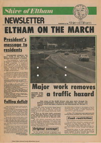
Journal - Newsletter, Shire of Eltham, Shire of Eltham newsletter, 1979
Articles, some with photos. Subjects include President's message, Eltham-templestowe intersection, indoor recreational centre, Bridge over Watsons Creek, town square, list of councillors, forward planning, recreational faciliaites including Eltham town park, Hurstbridge hall, roads, community welfare services, eltham Community and reception centre opening, amenities for youth, concrete bridge at Arthurs creek and Mitton's Bridge at St Andrew's Newsprint, 4 pages harry gilham collection, intersection, round-about, recreation, recreational centre, watsons creek, town square, councilors, newsletter, planning, parks, hurstbridge hall, community welfare service, roads, eltham community and reception centre, youth, skateboard track, mitton's bridge, arthur's creek, fitzsimons lane, main road, road construction, rondabout -
Glenelg Shire Council Cultural Collection
Document - Charity Ball Ticket - Portland Benevolent Asylum and Hospital, n.d
Benevolent asylums were places that housed anyone who could not support themselves; these were usually the aged, infirm, disabled and destitute. Benevolent Asylums also served as immigrants' homes, blind asylums, orphanages, lying-in hospitals and lunatic asylums. Benevolent asylums were often associated with hospitals in rural towns; they have evolved into aged care homes and hospitals in larger towns. Portland Benevolent Asylum and Hospital was founded in 1849.Pale blue card ticket, rounded corners, gold edge, black print and script Charity ball in aid of the Bazaar fund on behalf of the Portland Benevolent Asylum and hospital. Double ticket 7s. 6dBack: '75' - black penportland benevolent asylum and hospital, social care, welfare -
Glenelg Shire Council Cultural Collection
Document - Ticket - Charity Ball, Portland Benevolent Asylum and Hospital, n.d
Benevolent asylums were places that housed anyone who could not support themselves; these were usually the aged, infirm, disabled and destitute. Benevolent Asylums also served as immigrants' homes, blind asylums, orphanages, lying-in hospitals and lunatic asylums. Benevolent asylums were often associated with hospitals in rural towns; they have evolved into aged care homes and hospitals in larger towns. Portland Benevolent Asylum and Hospital was founded in 1849.Pale blue card ticket, rounded corners, gold edge, black print, and script Charity Ball in aid of the Bazaar Fund on behalf of the Portland benevolent Asylum and hospital Double 7s6dBack: '80' black penasylum, social care, benevolent, charity, fundraising -
Glenelg Shire Council Cultural Collection
Memorabilia - Ball Ticket - Charity Ball, n.d
Portland Benevolent Asylum and Hospital was founded in 1849. Benevolent asylums were places that housed anyone who could not support themselves; these were usually the aged, infirm, disabled and destitute. Benevolent Asylums also served as immigrants' homes, blind asylums, orphanages, lying-in hospitals and lunatic asylums. Benevolent asylums were often associated with hospitals in rural towns; they have evolved into aged care homes and hospitals in larger towns.Variegated card (orange, yellow, green) ticket, gold edge, black print and text. Charity ball in aid of the Bazaar Fund, on behalf of the Portland Benevolent Asylum and hospitalBack: '98' black pen -
Glenelg Shire Council Cultural Collection
Document - Ball Ticket - Charity Ball in aid of the Bazaar Fund on behalf of the Portland Benevolent Asylum and hospital, n.d
Benevolent asylums were places that housed anyone who could not support themselves; these were usually the aged, infirm, disabled and destitute. Benevolent Asylums also served as immigrants' homes, blind asylums, orphanages, lying-in hospitals and lunatic asylums. Benevolent asylums were often associated with hospitals in rural towns; they have evolved into aged care homes and hospitals in larger towns. Portland Benevolent Asylum and Hospital was founded in 1849Cream card ticket, gold edge, two red and blue stripes diagonally, across ticket, black print and script. Charity Ball in aid of the Bazaar Fund on behalf of the Portland Benevolent Asylum and hospital. Single ticket 55.Back: '67' Black ink -
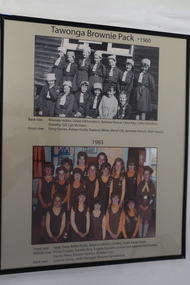 Kiewa Valley Historical Society
Posters - "Tawonga Remembers" x 5
The town of Tawonga is in the Kiewa Valley surrounded by farmland. It is adjacent to Mt Beauty (built in 1946) , an SECV town built for the workers on the Kiewa Hydro Electric Scheme which was being constructed from 1911-1961. Tawonga consisted of essential amenities including a store, school, butter factory, sporting facilities, post office, hall and hotel. Activities involved sport, social get togethers eg. dances, fundraising, CWA etc.The posters are a collection of historical photos, documentation and information regarding the history of the town of Tawonga, which is the centre of a faming community in the Kiewa Valley.Posters framed with thin black plastic strip, covered, by glass. Each one has a title re "Tawonga Remembeers" and includes print and photos in black and white. Beige background. 1. The History of Guiding in Tawonga; 2. Tawonga Cubs; 3. Cubs and Scouts; 4. Tawonga Brownie Pack -1960; 5. Tawonga Guide Company -1966tawonga, photos of early tawonga, kiew valley, tawonga remembers, cubs, scouts, brownies, guides -
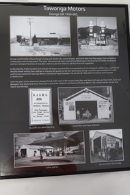 Kiewa Valley Historical Society
Posters - "Tawonga Remembers" x 4
The town of Tawonga is in the Kiewa Valley surrounded by farmland. It is adjacent to Mt Beauty (built in 1946), an SECV town built for the workers on the Kiewa Hydro Electric Scheme which was being constructed from 1911 to 1961. Tawonga consisted of essential amenities including a store, school, butter factory, sporting facilities, post office, hall and hotel. Activities involved sport, social get togethers eg. dances, fundraising, CWA etc.The posters are a collection of historical photos, documentation and information regarding the history of the town of Tawonga,which is the centre of a farming community in the Kiewa Valley.Poster framed with thin black plastic strip, covered, by glass. Each one has a title re "Tawonga Remembers" and includes print and phtots in black and white. Black background. 1. Tawonga SEC Depot; 2. Tawonga Service Station circa 1940s; 3. George Johnston's Taxi Service; 4. Tawonga Motors 1950-60stawonga, photos of early tawonga, kiewa valley, tawonga remembers, transport -
Port Melbourne Historical & Preservation Society
Photograph - Beach Street, Sandridge, William S Paterson, 1920s
Photographed in 1872 by William PATERSON as one of a series for the Melbourne Exhibition of 1873; original mount hanging in Engineering Department at Port Melbourne Town Hall at 19-9-1994 but now in Port Phillip,City Collection. This set of original prints belonged to Town Clerk Syd ANDERSON, then to his daughter-in-law Phyllis ANDERSON (donor). Accompanied by list of captions, both hand written and typed (the latter a partial listing).View of Beach Street from gate at Port Melbourne railway station entrance (corner of Railway Place and Princes Street). Shows Urquhart London Hotel, shops later replaced by Swallow & Ariell, carriages, sugar works chimney, etc 1872"P Anderson" on back, ink. On face of photo someone has in the 1990s added a numeral in ink 9hile with the donor. This has been retouched out on our digital copies.transport - horse, transport - railways, london family hotel, beach street, sydney sims anderson, town clerks, business and traders - hotels -
Port Melbourne Historical & Preservation Society
Photograph - Lagoon from the Sugar Works, Sandridge, William S Paterson, 1872
Photographed in 1872 by William PATERSON as one of a series for the Melbourne Exhibition of 1873; original mount hanging in Engineering Department at Port Melbourne Town Hall at 19-9-1994 but now in Port Phillip,City Collection. This set of original prints belonged to Town Clerk Syd ANDERSON, then to his daughter-in-law Phyllis ANDERSON (donor). Accompanied by list of captions, both hand written and typed (the latter a partial listing).Portion of lagoon photographed from Sugar Works, showing Rouse and Graham Street footbridges, Dow Street, Emerald Hill (view toward northeast). 1872"P Anderson" on back, ink. On face of photo someone has in the 1990s added a numeral in ink 9hile with the donor. This has been retouched out on our digital copies.sandridge lagoon, victorian sugar works, sydney sims anderson, town clerks, business and traders - hotels -
Port Melbourne Historical & Preservation Society
Photograph - Station Hotel, Sandridge, Roger Gould?, 1871
Photographed in 1872 by William PATERSON as one of a series for the Melbourne Exhibition of 1873; original mount hanging in Engineering Department at Port Melbourne Town Hall at 19-9-1994 but now in Port Phillip,City Collection. This set of original prints belonged to Town Clerk Syd ANDERSON, then to his daughter-in-law Phyllis ANDERSON (donor). Accompanied by list of captions, both hand written and typed (the latter a partial listing). Glossy print, copy of photo c1871 of early Station Hotel from the footbridge over the railway line, prior to extension of Bridge Street over the railway. Shows Presbyterian Church, carriages, a number of people, geese on the Railway Reserve.religion - presbyterian church, costume, transport - horse, parks and gardens, sydney sims anderson, town clerks, bridge street, railway reserve, business and traders - hotels -
Port Melbourne Historical & Preservation Society
Photograph, Bay & Rouse Streets, Sandridge, c. 1871
Photographed in 1872 by William PATERSON as one of a series for the Melbourne Exhibition of 1873; original mount hanging in Engineering Department at Port Melbourne Town Hall at 19-9-1994 but now in Port Phillip,City Collection. This set of original prints belonged to Town Clerk Syd ANDERSON, then to his daughter-in-law Phyllis ANDERSON (donor). Accompanied by list of captions, both hand written and typed (the latter a partial listing). COPYRIGHT Port Phillip City Collection pm0340 View northwest from the Victorian Sugar Works c1872, showing back of Post Office/Mail Exchange, Bay and Rouse Streets, Wesleyan Methodist and Presbyterian churches, police precinst, Exchange, Victoria and Ship Inn hotels, various traders etc, and corner of residence of Frederick POOLMAN, Manager of the Sugar Works."P. Anderson" ink, on back:"9" ballpoint, on upper left face of photoreligion - wesleyan methodist church, industry - manufacturing, built environment - civic, built environment - commercial, sydney sims anderson, town clerks, robert harper & co ltd, post office, mail exchange, david thomas, business and traders - hotels -
Port Melbourne Historical & Preservation Society
Photograph - Bay Street, Sandridge, 1870s
Photographed in 1872 by William PATERSON as one of a series for the Melbourne Exhibition of 1873; original mount hanging in Engineering Department at Port Melbourne Town Hall at 19-9-1994 but now in Port Phillip,City Collection. This set of original prints belonged to Town Clerk Syd ANDERSON, then to his daughter-in-law Phyllis ANDERSON (donor). Accompanied by list of captions, both hand written and typed (the latter a partial listing).View southeast in Bay Street from roof of building on north west corner of Bay and Liardet Streets c1871. Includes hotel identified in caption as "Foundry" on opposite corner (if captions were written in the 1920s the Port Theatre had already been constructed at this site, but there once was a 'Foundry' Hotel on that corner*); ginger beer/lemonade factory (Dawborns?) and pawnbroker; Graham Family Hotel can be seen in the distance at far left; also Holy Trinity (iron, with tower), Victorian Sugar Works, Post Office/Mail Exchange. Pre 1873 * '...try Hotel' visible?"P. Anderson" ink, on back:"11" in ballpoint on upper left face of photoindustry - manufacturing, business and traders - pawnbrokers, sydney sims anderson, town clerks, bay street, liardet street, foundry hotel, business and traders - hotels -
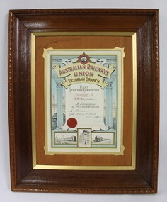 Wodonga & District Historical Society Inc
Certificate - Australian Railways Union, Victorian Branch, Past Officers Certificate, Wodonga Sub-Branch, 1926
The Wodonga line and train station opened in November 1873 when the section of the line from Wangaratta was completed. The expansion of the railways to the northeast of Victoria occurred after the Victorian Government took over the railways in 1867 and the trains serviced large towns such as Seymour, Wangaratta and Wodonga, as well as smaller towns along the way. The north- east train line to Wodonga remained a significant factor in the development of Wodonga as a rural city in the 20th century. The Past Officers Certificate has local significance as it was presented to Wodonga resident, Lachlan McEachern, who was President of the Wodonga Sub-Branch of the Victorian Branch of the Australian Railways Union, and there are other items that belonged to Mr Eachern in the collection of the Wodonga Historical Society. It also has wider significance as an example of a Past Officers certificate dated to the 1920s, as other examples in the collection of Museums Victoria are later and are dated to the 1930s, 1940s and 1950s. Dark brown wooden frame with a lighter brown wood and gold inner border on a Past Officers Certificate from the Victorian Branch of the Australian Railways Union, presented to L. McEachern in 1926, in recognition of services rendered as President of the Wodonga Sub-Branch. The certificate is a colour lithograph with black and white photolithograph images and a red embossed seal. The inscription on the certificate is surrounded by two Corinthian columns and a background illustration of a signal gantry at Flinders St Station. The signatures of the State President and State Secretary are faded. At the bottom of the certificate, there are black and white images of a suburban electric passenger train, "Unity Hall" which is the building where the Australian Railway Union offices were located and a steam train."AUSTRALIAN RAILWAYS UNION" "A.R.U" "AUSTRALIAN RAILWAYS / UNION / VICTORIAN BRANCH" "Presented to / L.McEachern / In Recognition / of Services Rendered / As President / of the Wodonga Sub-Branch /Year 1926" "State President / State Secretary"australian railways union, a.r.u., a.r. u. victorian branch, wodonga sub-branch, victorian railways, v.r., past officers certificate, flinders st station, railway unions, trade unions -
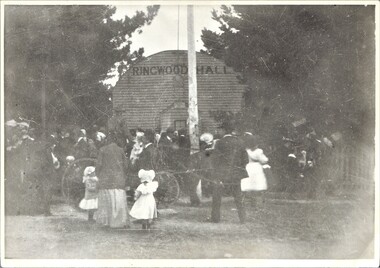 Ringwood and District Historical Society
Photograph, Ringwood Hall, Mount Dandenong Road, Ringwood - circa 1900, Circa 1900
Ringwood Hall was located near the Club Hotel in Mount Dandenong Road prior to construction of Mechanics Institute/Town Hall in Maroondah Highway in 1909.Black & white photo of crowd gathered at original Ringwood Hall, Mount Dandenong Road, Ringwood. "Old Ringwood Hall nr. Club Hotel, later burnt down approx 1909". "Old Ringwood Hall prior to Mech Inst of 1909". -
 Kiewa Valley Historical Society
Trophies - Tawonga Bowling Club x2, 1.1986. 2. 1987
Bowling in the Kiewa Valley is a popular sport with clubs in each town along the Kiewa Valley. Trophies are a common way of acknowledging winners in the various catagories.Vera Hore lived in Tawonga and was a successful bowler.1. Plastic silver V shaped trophy with Ball enclosed at top. On the ball are 2 bowls in black and blue with a blue kitty. These are surrounded by green. The trophy is mounted on a wooden block which has an inscription on a gold plate at the front. 2. Gold plastic woman bowler mounted on a wooden block which has an inscription on a gold plate at the front.1. 'Vera Drummond Trophy / 2.2.1986 / V. Peers (S). V. Hore, G. Hobbs' 2. 'Muriel Jobling Memorial / 1987 (3RD) / V. Hore' 2. Stamped underneath - "The Trophy Centre / 558 David St. Albury / Ph. 216588"tawonga bowling club, vera hore -
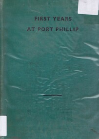 Greensborough Historical Society
Book, First Years at Port Phillip: by Robert Douglass Boys, 1935_
A history of the discovery of Australia with emphasis on the settlement of Victoria or 'Australia Felix' from the Henty Brothers in Portland in 1834 to the proclamation of the Town Coucil of Melbourne in 1842Chronology of the development of white settlement in VictoriaHard cover, green binding., title in black text on front cover. 158 pages. A chronology of Victoria from 1834 to 1842. Includes newspaper articles relating to the book pasted in front end paper.Inscribed on fly-leaf by author "To A R Kenyon with kind regards R D Boys August 8,1935."victoria-history henty-brothers portland australia-felix melbourne-history -
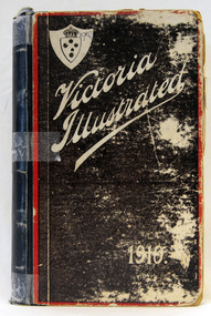 Orbost & District Historical Society
book, Government Printer, Victoria Illustrated - 1910, 1910
"This is an illustrated trip through some of the most important and picturesque towns, with short articles touching upon the industries of the state of Victoria. Distributed gratis by the Government".This is a useful reference book. A worn,294 pp hard cover book with a dark brown cover. The title, "Victoria Illustrated" is written diagonally across the top in white print inside a red border. The spine is blue. It contains advertisements, sepia photographs and text.book-victoria-illustrated -
Port Melbourne Historical & Preservation Society
Book - Town of Port Melbourne, Rats Cash Book, 1900s
Town of Port Melbourne ledger recording bounties paid for rats May 1905 to Feb 1907; cash book. Many signatures appear to be by children. Ledger, RATS label on spine; florentine coloured cover.local government - town of port melbourne, health - general health, domestic life - pets and pests, rats -
 Victorian Interpretive Projects Inc.
Photograph - colour, Clare Gervasoni, Rock Art in the Playground of the Former Dry Diggings Primary School, 05/08/2004
The Dry Diggings area is located outside Hepburn Springs in the shadow of Mount Franklin. It was an early goldmining area, but little remains of the thriving town of the 1860s. Colour photograph in digital format of the shape of Australia carved into a rock in the playground of the former Dry Diggings Primary School near Hepburn Springs and Daylesford. The carved area has been filled with white quartz stone. dry diggings, education, rock, -
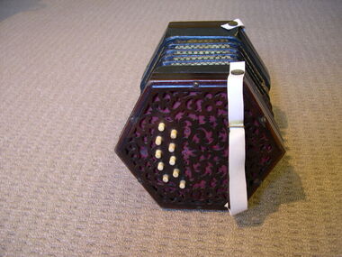 Creswick Museum
Musical Instrument, Lachenal & Co
The concertina was owned by Simon McDonald. He gave the concertina to Myrtle Porter in exchanged for town water. Simon McDonald lived in Melbourne Rd., Creswick.Simon McDonald (1906 - 1968) was a noted self taught Australian folk musician whose home was in Creswick. Consider in the industry as the most important.20 Button Anglo Concertina & Case. Hexagon shaped Concertina. Both sides have fretwork and 10 bone buttons making it a 20 plus single button Anglo concertina. The leather straps have at sometime been replaced with white plastic strap. It has 5 bellows in black and white pattern leather. The hexagon wood case is lined, although the lining is showing wear.One side: small disc with Lachenal & Co., Patent Concertina Manufacturers, London. Opposite side: Initials on red card J.W.Gsimon mcdonald, anglo concertina, creswick -
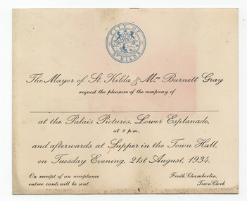 St Kilda Historical Society
Ephemera - Invitation - mayoral dinner, St Kilda Mayor's invitation to Palais Pictures and Supper, 1934
Invitation from St Kilda Mayor, Burnett Gray, to the Palais Pictures, followed by supper in the St Kilda Town Hall, on 21 August 1934.Cream card, discoloured with age, printed in black with City of St Kilda logo in bluepalais pictures, city of st kilda -
Tatura Irrigation & Wartime Camps Museum
Book, Old Pioneering Days in the Sunny South, 1907
Recording history of NSW pioneering days, including stories of W C Wentworth, J H Hume, the town of Goulburn, Bushrangers droving, the Duracks.Red hardcover, gold lettering, imprint of stockman and horse on front cover Yours Sincerely, Chas MacAlister, (Author) and C F McHardyearly australian history, nsw pioneering days, w c wentworth, j h hume, busrangers, duracks -
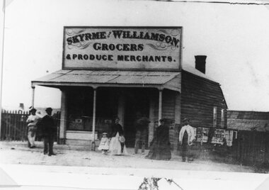 Stawell Historical Society Inc
Photograph, Skyrme & Williamson -- Grocers and Produce Merchants in Main Street Stawell
Skyrme & Williamson Grocers and Produce Merchants Main Street Stawell along from St George Street corner but before the Town Hall Hotel.stawell businesses -
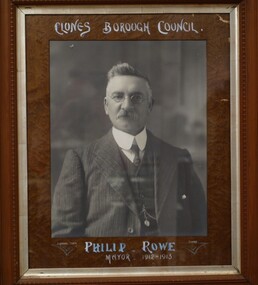 Clunes Museum
Photograph, J. HORNBY, CLUNES, 1912
IT IS ON PERMAMENT LOAN FROM HEPBURN SHIRE CR. PHILIP ROWE SERVED AS MAYOR 1912-1913. THE PHOTOGRAPH ORIGINALLY HUNG IN CLUNES TOWN HALL .FRAMED PHOTOGRAPH OF CR. PHILIP ROWECLUNES BOROUGH COUNCIL. PHILIP ROWE MAYOR 1912-1913 J. HORNBY PHOTO. CLUNES.local history, photography, photographs, councillors & officers