Showing 993 items
matching paddocks
-
 Tarnagulla History Archive
Photograph of police buildings in Tarnagulla, Police buildings in Tarnagulla, 31st January 1924
Murray Comrie Collection. The buildings in this image are (from left to right) the lockup, stable and office of the Tarnagulla Police complex. At far left a small part of the rear of the policeman's residence is visible. This residence is clearly depicted in THA-2019.0030. Behind the residence and outbuildings (in background of this photo) was an adjoining paddock for the police horses. This town block was the base for policing in Tarnagulla from 1878 until the 1990s. At the time of this photo (1924), Angus Comrie Snr was the constable for Tarnagulla, living at the police residence with his family. The residence was sold for removal in in the 1960s and replaced with a prefabricated residence and small office from Bealiba which were used until the 1990s. These as well as the lockup are still in place (as of 2019) on the corner of Victoria and Gladstone Streets. There are now private residences built on the former police horse paddock. For over 100 years the Comrie name has been involved with the Victoria Police. Angus Comrie Snr, joined the force in 1899 and served as constable in Kaniva and Avoca and then in Tarnagulla from late 1909 until 1927. His son Murray Comrie, born in Tarnagulla in 1912 also became a policeman and later a Chief Superintendent, retiring in 1972 and passing away in 1983 after a long illness. Murray Comrie's son Murray Jnr., to avoid confusion became known by his middle name, Neil. Neil Comrie also joined Victoria Police and and rose through the ranks to become Chief Commissioner of Victoria Police from 1993 to 2001. The Murray Comrie Collection held by Tarnagulla History Archive was collated in the 1970s by Murray Comrie (1912-1983).Sepia photographic postcard, image depicting members of the Angus Comrie family standing among police outbuildings in Tarnagulla. Based on the note on reverse of THA-2019.0030, the subjects are probably (left to right): Hilda Comrie (b.1904, married in1907 to Alf Clarke), Roy Comrie (b.1921), Keith Comrie (b.1911, d.1934) and either Angus Comrie Jr. (b.1909) or Murray Comrie (b. circa 1912). See second image for handwritten notes on reverse.tarnagulla, police, policing, comrie -
 Linton and District Historical Society Inc
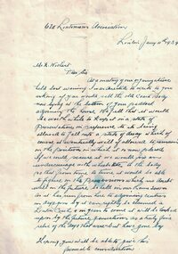
Letter, Old Lintonians' Association to Mr. Wishart, 1939
Handwritten letter to Mr. Wishart regarding an old coach body on his property that the Old Lintonians' Association would like to preserve.Text: " Old Lintonians' Association / Linton Jary 4th 1939 / Mr. H. Wishart / Dear Sir / At a meeting of our organization / held last evening I was directed to write to you / asking if you would sell the old Coach Body / now lying at the bottom of your paddock / adjoining the house. We feel that it would be worthwhile to keep it in a state of / preservation to its being / allowed to fall into a state of decay which of / course it eventually will if allowed to remain / in the position in which it is now placed. "old lintonians' association, mr. wishart -
 Federation University Historical Collection
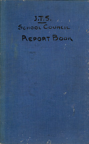
Book, Ballarat Junior Technical School Council Report Book, 1923-1949, 1923-1949
The Ballarat Junior Technical School opened in 1913 under the jurisdiction of the Ballarat School of Mines. The first Principal was Albert W. Steane. Blue, hardcovered book with blue lined pages that have been written on in ink. The reports from 1923 are written by Ballarat Junior Technical School Principal Albert Stean, and have been countersigned by William Henry Middleton. From 1944 the reports were signed by C. Jeffery. and the one from 1949 they was signed by Mr Cutter. Contents include enrolment numbers, White Flat Improvement Committee, School Fair, Wireless Club, garden improvements, swimming, sports, Mothers' Club, Battery Paddock, football, orphanage boys, choir, scholarships, Empire Youth Day, ballarat junior technical school, bjts, junior technical school, middleton, steane, white flat, white flat improvement committee, wireless club, ripper, calder. whitla, jeffrey, ballarat school of mines, albert steane, w. middleton, r.v. maddison, w. trendle, c. whitla, william h. clarke, george dimsey, lancelot g. chegurni, w. hill, student statistics, a.e. potter, ana, a.j. reid, a.c. miller, charles jeffery, library, scholarships, victor cole, alan snell, raymond gleeson, william cooper, kenneth smith, kenneth williams, c. jeffery, r. cutter -
 Federation University Historical Collection
Map, Ballarat Goldfield, c1898
This map shows geological features, suggests the last basalt flow, and includes alotments and names of Mining Companies. Although this map has no date on it the Ballarat Industrial School is used for dating purposed. The Ballarat Industrial School ran from 1869-1879, but the term Ballarat Industrial School Reserve was still in use in 1898 and possibly beyond.Geological Map of Ballarat with 3 holes in the left hand side. The map indicates the position of Lake Wendouree, Township of Warrenheip, Ballarat East, Industrial School Reserve, Winters Swamp, Police Paddock, Wyndholm Premptive Right (Salton and Waldie), Black Hill, Vale Park Reserve, Pennyweight Hill, Little Bendigo, Black Swamp Lead, monte Christo Reef, Chinaman's Gully, Miners Rest, Pincotts Dam, Northumberland Gully. It also show the following goldmining companies: City of Ballarat, Kohinor, Hand and Band, Great North West, Northern Junction, Kneeshaw, Rossers Freehold, Silurial.ballarat, warrenheip, lake wendouree, ballarat east, winters swamp, winter swamp, wyndholm premptive right, cemetery, vale park reserve, little bendigo, kneeshaw co., industrial school reserve, kirks dam, pincotts dam, black hill, wombat hill, dead horse gully, miners rest, mt rowan, salton and waldie, rose hill co, great north west no 1, rose's freehold co, hand and band co, police reserve, police paddock, mount rowan, ballarat industrial school reserve, market reserve, winter's swamp, kneeshar co, monte cristo line of reef, chinaman's gully or black snake, milkmaid's gully, ballarat gold field, bakery hil lead, old gravel pits lead, golden point lead, eureka lead, miner's rest, yarrowee creek, leigh creek, black swamp lead, yorkshire reef, nil desperandum reef, cockatoo lead, hit or miss gully, herbert werner frederick de nully, pennyweight hill, esmond's lead, ash's lead, nightingale lead, john bull gully, gladstone reef, whitehorse reef, petticoat creek, pincott's dam, frenchman's gully, tim's crushing plant, jenkin's gully, california gully, drake's creek, sulton and waldie, ballarat undustrial school, ballarat & mariborough railway -
 Orbost & District Historical Society
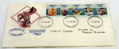
first day cover, Connell, Lee, June 1987
The Man from Snowy River" is a poem by Australian bush poet Banjo Paterson. It was first published in The Bulletin, an Australian news magazine, on 26th April 1890. The poem tells the story of a horseback pursuit to recapture the colt of a prizewinning racehorse that escaped from its paddock and is living wild with the brumbies (wild horses) of the mountain ranges. Eventually the brumbies descend a seemingly impassably steep slope, at which point the assembled riders give up the pursuit, except the young hero, who spurs his pony down the "terrible descent" to catch the mob.Two characters mentioned in the early part of the poem are featured in previous Paterson poems; "Clancy of the Overflow" and Harrison from "Old Pardon, Son of Reprieve".The town of Orbost is situated on the Snowy River and the town has always been "the heart of Snowy River country".A first day cover for "The Man From Snowy River" stamps. There is a picture of a saddle in the top left-hand corner. There is a strip 5 stamps on the envelope and it has been stamped at Orbost Post Office. This strip has 5 scenes based on the Banjo Patterson legendary poem by the same name. The stamps include: At The Station, Mountain Bend, The Terrible Descent, At Their Heels and Brought Them Back.first-day-cover man-from-snowy-river stamps philately -
 Whitehorse Historical Society Inc.
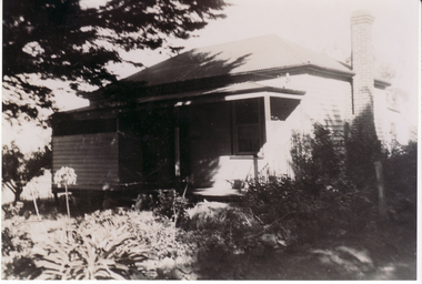
Photograph, 'Marple' Orchard Grove Blackburn South
Annie and William Booth, with their five children, left England to migrate to Australia in 1923. They came on the maiden of the S.S.Demosthenes. They bought and occupied land - six and half acres in Orchard Grove, Blackburn South - from 1923 to 1942 when the moved to Salisbury Street, Mont Albert.|William Booth obtained an office position with Danks where he remained till retirement.|The home in Orchard Grove was called 'Marple' after the place in England where the honeymooners.|They ran poultry and an orchard - apples, plums, quinces and peaches which were sold for additional income. This was fairly common at the time for the man to have a job but to use their property for extra income.|The Anglican Church is built on the Booth's top paddockBlack and white photograph of of 'Marple', the Booth family home on Orchard property in Orchard Grove, South Blackburn.marple, booth family, orchard grove, blackburn south, anglican church -
 Kew Historical Society Inc
Photograph, Floods in North Kew, 1971
Living with natural processes was frequently a challenge to early European settlers and later residents of what was in the 1850s administered by the Borondara Road Board. This was compounded by the area being bounded on three sides by rivers (Yarra River, Koonung Creek and Gardiner's Creek). In 1849, the historian James Bonwick recorded that "our district [Kew] suffered considerably. Mr Wade speaks of 80 acres, out of 100 acres of his cultivated paddock, covered by water." Newspapers continued to describe major flooding in Kew in 1863, 1869, 1878, 1880, 1889, 1891, 1916 and 1934. While the construction of the Upper Yarra dam in 1957 reduced the levels of flowing downstream, local and riverine floods continue.The Kew Historical Society's pictures and map collections testify to the impact of flooding in the district. They have historical importance in documenting the extent of flooding in the district and its affects on homes, services and recreation. Numerous photographs record flooding throughout the Twentieth Century.Floods in North Kew, 1971. Looking northeast towards Kilby Road from River Avenue. Annotation on reverse: map and date "8 Nov. 71 10.30am".floods (kew), yarra river, kew flood, kilby road flood -
 Kew Historical Society Inc
Photograph, Floods in North Kew, 1934
Living with natural processes was frequently a challenge to early European settlers and later residents of what was in the 1850s administered by the Borondara Road Board. This was compounded by the area being bounded on three sides by rivers (Yarra River, Koonung Creek and Gardiner's Creek). In 1849, the historian James Bonwick recorded that "our district [Kew] suffered considerably. Mr Wade speaks of 80 acres, out of 100 acres of his cultivated paddock, covered by water." Newspapers continued to describe major flooding in Kew in 1863, 1869, 1878, 1880, 1889, 1891, 1916 and 1934. While the construction of the Upper Yarra dam in 1957 reduced the levels of flowing downstream, local and riverine floods continue.The Kew Historical Society's pictures and map collections testify to the impact of flooding in the district. They have historical importance in documenting the extent of flooding in the district and its affects on homes, services and recreation. Numerous photographs record flooding throughout the Twentieth Century.Floods in North Kew, 1934. Vicinity of Willsmere Park.floods (kew) -
![Flooding at Chipperfield's Boathouse [East Kew], 1934](/media/collectors/550653872162f11fb04854aa/items/58cbaad5d0cec425b474bfb1/item-media/58cf6fbdd0cf9f331490feb0/item-fit-380x285.jpg) Kew Historical Society Inc
Kew Historical Society IncPhotograph, Flooding at Chipperfield's Boathouse, 1934
Living with natural processes was frequently a challenge to early European settlers and later residents of what was in the 1850s administered by the Borondara Road Board. This was compounded by the area being bounded on three sides by rivers (Yarra River, Koonung Creek and Gardiner's Creek). In 1849, the historian James Bonwick recorded that "our district [Kew] suffered considerably. Mr Wade speaks of 80 acres, out of 100 acres of his cultivated paddock, covered by water." Newspapers continued to describe major flooding in Kew in 1863, 1869, 1878, 1880, 1889, 1891, 1916 and 1934. While the construction of the Upper Yarra dam in 1957 reduced the levels of flowing downstream, local and riverine floods continue.The Kew Historical Society's pictures and map collections testify to the impact of flooding in the district. They have historical importance in documenting the extent of flooding in the district and its affects on homes, services and recreation. Numerous photographs record flooding throughout the Twentieth Century.Floods in North Kew, 1934. Chipperfield's Boathouse and the adding Moorings was located beside the Yarra River near the corner of Willsmere and Kilby Roads. The flood reached the roof of the Moorings, which can be seen in the photo.floods (kew), floods (kew) 1934, yarra river -
 Kew Historical Society Inc
Photograph, Floods in North Kew, 1934
Living with natural processes was frequently a challenge to early European settlers and later residents of what was in the 1850s administered by the Borondara Road Board. This was compounded by the area being bounded on three sides by rivers (Yarra River, Koonung Creek and Gardiner's Creek). In 1849, the historian James Bonwick recorded that "our district [Kew] suffered considerably. Mr Wade speaks of 80 acres, out of 100 acres of his cultivated paddock, covered by water." Newspapers continued to describe major flooding in Kew in 1863, 1869, 1878, 1880, 1889, 1891, 1916 and 1934. While the construction of the Upper Yarra dam in 1957 reduced the levels of flowing downstream, local and riverine floods continue.The Kew Historical Society's pictures and map collections testify to the impact of flooding in the district. They have historical importance in documenting the extent of flooding in the district and its affects on homes, services and recreation. Numerous photographs record flooding throughout the Twentieth Century.Floods in North Kew, 1934. Unidentified location on the Yarra Flood Plain at Kew.floods (kew) 1934, yarra river -
 Kew Historical Society Inc
Photograph, Floods in North Kew, 1934
Living with natural processes was frequently a challenge to early European settlers and later residents of what was in the 1850s administered by the Borondara Road Board. This was compounded by the area being bounded on three sides by rivers (Yarra River, Koonung Creek and Gardiner's Creek). In 1849, the historian James Bonwick recorded that "our district [Kew] suffered considerably. Mr Wade speaks of 80 acres, out of 100 acres of his cultivated paddock, covered by water." Newspapers continued to describe major flooding in Kew in 1863, 1869, 1878, 1880, 1889, 1891, 1916 and 1934. While the construction of the Upper Yarra dam in 1957 reduced the levels of flowing downstream, local and riverine floods continue.The Kew Historical Society's pictures and map collections testify to the impact of flooding in the district. They have historical importance in documenting the extent of flooding in the district and its affects on homes, services and recreation. Numerous photographs record flooding throughout the Twentieth Century.Floods in North Kew, 1934. Chipperfield's Boat House under flood.floods (kew) 1934, yarra river, chipperfield's boat house -
 Kew Historical Society Inc
Photograph, Floods in North Kew, 1934
Living with natural processes was frequently a challenge to early European settlers and later residents of what was in the 1850s administered by the Borondara Road Board. This was compounded by the area being bounded on three sides by rivers (Yarra River, Koonung Creek and Gardiner's Creek). In 1849, the historian James Bonwick recorded that "our district [Kew] suffered considerably. Mr Wade speaks of 80 acres, out of 100 acres of his cultivated paddock, covered by water." Newspapers continued to describe major flooding in Kew in 1863, 1869, 1878, 1880, 1889, 1891, 1916 and 1934. While the construction of the Upper Yarra dam in 1957 reduced the levels of flowing downstream, local and riverine floods continue.The Kew Historical Society's pictures and map collections testify to the impact of flooding in the district. They have historical importance in documenting the extent of flooding in the district and its affects on homes, services and recreation. Numerous photographs record flooding throughout the Twentieth Century.Floods in North Kew, 1934. Flood near the lagoon (Billabong?)floods (kew) 1934, yarra river -
 Eltham District Historical Society Inc
Slide - Photograph, Sensory Integration Invention A, Cathy Smith (1999), Fergusons Paddock, Arthurs Creek Road, Hurstbridge, c.Nov. 2001
Sensory Integration Invention A, by Cathy Smith public art sculpture, commissioned by Nillumbik Shire Council, in Fergusons Paddock,12 Arthurs Creek Road Hurstbridge was officially unveiled in 1999. Councillors Penny Mullinar and Margaret Jennings in attendance. "Smith's work has strong references to humans' sensory and practical relationship with the land through the built environment. Wind entering the structure's tubing operates like a flute, generating sounds such as bird calls that resonate into the surrounding wetland areas." Source: Highlights from the Nillumbik Public Art Collection, NSC, n.d. Part of a slide show presentation "A Trip Down the Diamond Creek" by Russell Yeoman to the Eltham District Historical Society meeting of 14 Nov. 200135mm colour positive transparency Mount - Black and Whiteart in public places, arthurs creek road, cathy smith, ferguson's paddock, hurstbridge, public art, sensory integration invention a -
 Kew Historical Society Inc
Plan, Melbourne & Metropolitan Board of Works : Borough of Kew : Detail Plan No.1296, 1904
The Melbourne and Metropolitan Board of Works (MMBW) plans were produced from the 1890s to the 1950s. They were crucial to the design and development of Melbourne's sewerage and drainage system. The plans, at a scale of 40 feet to 1 inch (1:480), provide a detailed historical record of Melbourne streetscapes and environmental features. Each plan covers one or two street blocks (roughly six streets), showing details of buildings, including garden layouts and ownership boundaries, and features such as laneways, drains, bridges, parks, municipal boundaries and other prominent landmarks as they existed at the time each plan was produced. (Source: State Library of Victoria)This plan forms part of a large group of MMBW plans and maps that was donated to the Society by the Mr Poulter, City Engineer of the City of Kew in 1989. Within this collection, thirty-five hand-coloured plans, backed with linen, are of statewide significance as they include annotations that provide details of construction materials used in buildings in the first decade of the 20th century as well as additional information about land ownership and usage. The copies in the Public Record Office Victoria and the State Library of Victoria are monochrome versions which do not denote building materials so that the maps in this collection are invaluable and unique tools for researchers and heritage consultants. A number of the plans are not held in the collection of the State Library of Victoria so they have the additional attribute of rarity.Original survey plan, issued by the MMBW to a contractor with responsibility for constructing sewers in the area identified on the plan within the Borough of Kew. The plan was at some stage hand-coloured, possibly by the contractor, but more likely by officers working in the Engineering Department of the Borough and later Town, then City of Kew. The hand-coloured sections of buildings on the plan were used to denote masonry or brick constructions (pink), weatherboard constructions (yellow), and public buildings (grey). This area was once known as O’Shaughnessy’s Paddock. O’Shaughnessy was the licensee of the Kew Hotel. The ‘Paddock’ or farm was for many years the closest farm to Melbourne. By 1903, when this plan was surveyed and lithographed, little of the farm remained. The area is dominated by a ‘clay hole’, on the site of the current Foley Reserve. It was used by Smart’s Brickyard from the 1880s until 1911, when the Council purchased it for a rubbish dump. It is notable as the site is one of the few industrial operations to have existed in Kew. By 1903, urban development was characterised by larger houses fronting Barkers Road and brick and weatherboard villas in Foley Street. Nearer the pit, weatherboard houses predominated. Foley Street bisected the triangular block and continued right to Denmark Street. At this stage, a house impeded the through road, only allowing access via a right of way to High Street.melbourne and metropolitan board of works, detail plans, mmbw 1296, cartography -
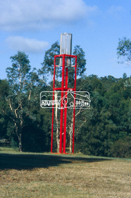
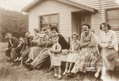
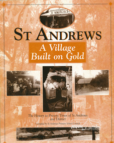
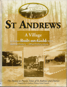 Eltham District Historical Society Inc
Book, St Andrews Primary School Council, St Andrews: A Village Built on Gold : the history to present day of St Andrews and District compiled by St Andrews Primary School Council, 2008
This history of the Victorian town of St. Andrews (formerly Queenstown) and its surroundings was written to celebrate the 140th anniversary of St Andrews Primary School. Describes the displacement of the Aboriginal inhabitants of the area, European settlement and the Gold Rushes and the Caledonia diggings. Discusses establishment of the school, church and cemetery and various other notable events. The school in 1998 and speculations on the future by primary school pupils. Contents: Introduction The First People Mining- What a rush! The School The Church Queenstown Cemetery The Hotels The Police Paddocks The Families Queenstown in the early twentieth century The Queenstown Bush Fire Brigade The 1st Queenstown Scout troop Queenstown, the 1940s and 1950s The Characters Odds and Sods St Andrews - The Present Times The Future St Andres Primary School in 1998This book is significant in that it documents the history of the St Andrews community from the indigenous presence through its foundation during the Victorian Gold Rush through to local bushfires and predictions of the future by local primary schools students in 1998. It remains the only significant secondary source publication written specifically on this rural community.Reprint edition with index 158 p. : ill., ports ; indexEx Eltham College copy Bendigo bank donation label inside cover Title page with stampings for D.D. Davey Senior Library Rear page date due slip st andrews, queenstown -
 Eltham District Historical Society Inc
Photograph, Wattle Glen Picnic Ground, c.1955, 1955c
The Wattle Glen Picnic Ground was located in a paddock just west of the Wattle Glen railway station (between the station and the creek). It has now completely disappeared except for a dilapidated overgrown building on a rise across the track from the railway platform. This was the picnic ground's main pavilion, which for a short time (circa 1972-1974) also served as the Wattle Glen post office and general store. The picnic ground operated from circa 1925 until late 1974, its heyday being in the early 1970s. This photo shows a group of picnickers on an outing from the East Coburg Presbyterian Church in around 1955. They travelled to Wattle Glen in a furniture removal van, sitting on church pews in the back of the van. Digital copy of sepia photographwattle glen, picnic ground -
 Eltham District Historical Society Inc
Book, St Andrews Primary School Council, St Andrews: A Village Built on Gold : the history to present day of St Andrews and District compiled by St Andrews Primary School Council, 1998
This history of the Victorian town of St. Andrews (formerly Queenstown) and its surroundings was written to celebrate the 140th anniversary of St Andrews Primary School. Describes the displacement of the Aboriginal inhabitants of the area, European settlement and the Gold Rushes and the Caledonia diggings. Discusses establishment of the school, church and cemetery and various other notable events. The school in 1998 and speculations on the future by primary school pupils. Contents: Introduction The First People Mining- What a rush! The School The Church Queenstown Cemetery The Hotels The Police Paddocks The Families Queenstown in the early twentieth century The Queenstown Bush Fire Brigade The 1st Queenstown Scout troop Queenstown, the 1940s and 1950s The Characters Odds and Sods St Andrews - The Present Times The Future St Andres Primary School in 1998This book is significant in that it documents the history of the St Andrews community from the indigenous presence through its foundation during the Victorian Gold Rush through to local bushfires and predictions of the future by local primary schools students in 1998. It remains the only significant secondary source publication written specifically on this rural community.158 p. : ill., ports ISBN 0646353756st andrews, queenstown -
 Bendigo Historical Society Inc.
Document - EXTRACT FROM THE BENDIGO INDEPENDENT APRIL 16 1887: MYERS FAMILY/MYERS CREEK, 16th April, 1887
Extract from the Bendigo Independent April 16 1887 re Myers Family/Myers Creek. Titled The local dawn of civilization - A Pre-auriferous pioneer. Settlement by William and Thomas Myers. Story of settlement of area told by first wife of William Myers (Mrs Hayward). Recollection of Mrs Hayward's re the naming of Bendigo ( ('bendy-go'). Reference to Mr Campbell, Bullock Creek Hotel and Station; Mr John Catto (Loddon homestead); Mouat Bros (Yarraberb Station) M'Intyre (squatter of Kangaroo Flat and Big Hill) ; Buzza's Paddock (Myers' Flat). Mention of Superintendent Gilbert and Dr Backhaus.Bendigo Independentperson, individual, myers family, myers flat police station, buzz's paddock, bullock creek hotel and station, port phillip, myers creek. -
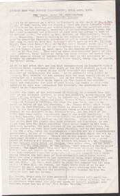
 Kew Historical Society Inc
Photograph - Horses grazing near Cockatoo, c.1926
Henry Beater Christian (1886-1962) , was a descendant of one of the earliest settler families in Kew. Employed at the Kew Asylum as a 'public servant', he was a skilled amateur photographer, photographing numerous scenes in Kew and on his travels around Victoria. The majority of his photographs date from 1916 to 1929. His finest photographs are housed in two photograph albums. Digital copy of a photograph from page 28 of the 47-page photograph album containing 261 gelatinous silver images, loaned by Diane Washfold with permission given to digitise and hold a copy in our collection. John Chapman has written in 'Bushwalking Clubs - A Brief History', about the establishment in Victoria of the first bushwalking club in 1888, and the popularisation of bushwalking during the interwar period. Henry Christian's 'walks' appear to have been undertaken solely or with a companion/s. This photo was taken on a trip between Cockatoo and Gembrook in Victoria and shows two horses grazing in a paddock to the left of an 'exotic' tree in full bloom. "Cockatoo & Gembrook [illegible]henry beater christian (1886-1962), landscape photography, christian-washfold collection, photograph albums, bushwalking, cockatoo, gembrook -
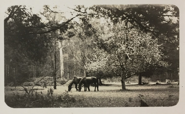
 Bendigo Historical Society Inc.
Book - BENDIGO JOCKEY CLUB CUP MEETING PROGRAMME, 19/11/1947
The Bendigo Jockey Club was formed in 1858 and the first Bendigo Cup was held in 1868.Bendigo Jockey Club Cup Meeting Programme: Cream card and paper with red and Brown print. Has a brown horse head inside a triangle that is in the centre of a three leaf clover design with the words Bendigo Jockey Club. Cup Meeting 1947 Official Programme. First Day. Wed. Nov. 19. Price one Shilling. Secretary P.H. Seeber Published by the Bendigo Jockey Club. Programme has 6 races. Names of all committee members with J.H. Lienhop, M.L.C. President. Admission prices, Rules and Regulations etc. All Paddock Bookmaker's Names and stand numbers. Box 625C. W. Seymour, Printer, Bendigoclubs, social, bendigo jockey club, bendigo jockey club -
 Kew Historical Society Inc
Plan, Melbourne & Metropolitan Board of Works : Borough of Kew : Detail Plan No.1297, 1904
The Melbourne and Metropolitan Board of Works (MMBW) plans were produced from the 1890s to the 1950s. They were crucial to the design and development of Melbourne's sewerage and drainage system. The plans, at a scale of 40 feet to 1 inch (1:480), provide a detailed historical record of Melbourne streetscapes and environmental features. Each plan covers one or two street blocks (roughly six streets), showing details of buildings, including garden layouts and ownership boundaries, and features such as laneways, drains, bridges, parks, municipal boundaries and other prominent landmarks as they existed at the time each plan was produced. (Source: State Library of Victoria)This plan forms part of a large group of MMBW plans and maps that was donated to the Society by the Mr Poulter, City Engineer of the City of Kew in 1989. Within this collection, thirty-five hand-coloured plans, backed with linen, are of statewide significance as they include annotations that provide details of construction materials used in buildings in the first decade of the 20th century as well as additional information about land ownership and usage. The copies in the Public Record Office Victoria and the State Library of Victoria are monochrome versions which do not denote building materials so that the maps in this collection are invaluable and unique tools for researchers and heritage consultants. A number of the plans are not held in the collection of the State Library of Victoria so they have the additional attribute of rarity.Original survey plan, issued by the MMBW to a sewage contractor with responsibility for constructing sewers in the area identified on the plan within the Borough of Kew. The plan was at some stage hand-coloured, possibly by the contractor, but more likely by officers working in the Engineering Department of the Borough and later Town, then City of Kew. The hand-coloured sections of buildings on the plan were used to denote masonry or brick constructions (pink), weatherboard constructions (yellow), and public buildings (grey). This plan of Kew encompasses the area bounded by Barkers Road, High Street and Stevenson Street. Because of the angle created by High Street, a number of houses on the northern side of High Street are shown. The area is dominated by one of the great original landholdings in Kew, described here as the ‘Findon Paddock’. ‘Findon’, the house from which the name of the paddock was taken fronts Stevenson Street and was clearly a rambling structure. The best-known occupant of Findon was Henry ‘Money Miller’ who bought the house in 1871. Miller was a member of Victoria’s first parliament and assisted in the framing of its constitution. Findon was to be subdivided as early as 1912, when the Findon Subdivision was advertised to be sold by auction. In the plan of the subdivision, the original house is not shown, so, presumably it had previously been demolished. Fincham & Son moved the organ, built by Henry Willis, which was installed in the house, first to ‘Whernside’ in Toorak, and later to the Box Hill Methodist Church.melbourne and metropolitan board of works, detail plans, mmbw 1297, cartography, kew (vic.) — municipal collection -
 Glen Eira Historical Society
Article - Billing, Richard Annesley
... Paddocks ...Two documents regarding Sylliot Hill, home of judge Richard Billings. 1. Three photocopies of the notice for sale/lease of Sylliot Hill, Judge Billing’s house, in The Argus of 02/09/1882 2. Handwritten research notes by Peta Darke, dated 24/05/2011, concerning the history of Judge Billing’s residence.mansion, sylliott hill, house names, balaclava road, orrong road, labassa, st kilda east, billing judge, judges, stables, coach houses, stained glass, ferguson and urie, crouch and wilson, towers, pearson william, paddocks, robertson alexander, cobb and co, ontario, verandahs -
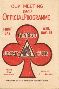
 Orbost & District Historical Society
bookmaker's bag, late 19th century
A Gladstone bag is a small portmanteau suitcase built over a rigid frame which could separate into two equal sections. Unlike a suitcase, a Gladstone bag is deeper in proportion to its length.They are typically made of stiff leather and often belted with lanyards. The bags are named after William Ewart Gladstone (1809–1898), the four-time Prime Minister of the United Kingdom. This one has been adapted to suit the needs of a bookmaker. The leather neck strap has been added. Horse racing was a popular past-time in early Orbost. The Nixon family was involved through Keith Nixon. Some of the earliest horse races were held on a course in a paddock belonging to Mr James Cowell at Jarrahmond. For a long time horse races were part of the Marlo Picnic Races.This item is connected to an activity once popular in the Orbost district. A very worn leather bookmaker's bag. It is a Gladstone style bag with a leather neck strap. It has a spring lock with a key hole. It has a curved handle at the top. The leather neck strap does not appear to be original. The inside lining is cotton and there is a metal hinged frame. On the base are four metal studs.On the base - SOLID LEATHERgladstone-bag bookmaker's-bag horse-racing -
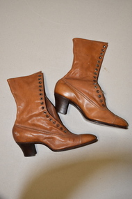 Warrnambool and District Historical Society Inc.
H. Perry & Co, Brown lace up boots x 2, 1906
These boots may have been made as a sample as they are a very small size and do not appear to have been worn. They come from the New Zealand International Exhibition held at Hagley Park, Christchurch from November 1906 to April 1907. This exhibition was the brainchild of the New Zealand Prime Minister, Richard Seddon who died before the exhibition opened. Nearly 2 million people visited the exhibition at a time when the population of New Zealand was less than one million. The exhibition was thus rated a success even though there was a financial loss. No information has been found on the bootmakers, H. Perry & Co. In the 19th and early 20th centuries boots were an essential item for women who often had to walk through unmade streets and muddy paddocks. This item is of interest as it is a memento of an important New Zealand Exhibition early in the 20th century. This is a pair of a lady’s light brown leather boots. The boots have long leather tongues with 16 eyelets either side to lace up the front instep. The laces are missing. The wooden heels are slightly raised. H. Perry & Co. New Zealand International Exhibition Christchurch 1906-7 vintage footwear, christchurch new zealand exhibition, 1906-7 -
 Surrey Hills Historical Society Collection
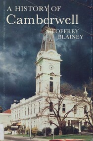
Book, A history of Camberwell, 1980
In 1964 Camberwell City Council commissioned Professor Geoffrey Blainey to first write this history. Since that time, many changes have taken place and therefore the Council asked Professor Blainey to bring the book up to date. Bibliography, includes index. The author presents a century of pioneering development and endeavours. He has traced the coming of the wood-cutters and the farmers, the transition from rectangular paddocks to a grid of roads and streets, the growth from shire to borough, town and city, the filling up of thirteen squares miles into residential suburbia - in successive waves of invasion, along new transport routes - including the Outer Circle Railway. Substantial chapters cover the War Years and the progress of Camberwell since the 1960s have also been included in this edition. 134p; ill;camberwell, victoria, market gardens, tolls, railways, mayors, boroondara road board, borondara shire, councillors, (mr) (prof) geoffrey blainey -
Ringwood and District Historical Society
Family History, Eva McLaren (now Moore), Single page dated 11 March 2003 - typed notes on the McLaren family having lived in the Bedford Road area of Ringwood from April 1927, 11-Mar-03
Single page of typed notes on the McLaren family having lived in the Bedford Road area of Ringwood from April 1927, headed "On The Street Where You Live" prepared by Eva McLaren (now Moore), dated 11 March 2003. +Additional Keywords: McLaren, Eva / McLaren, Rev Gilbert / McLaren, Dorothy / Wigley, Linda / Wigley, Evan / Wigley, Ralph / Wigley, Eslie / Wigley, Amy / Wigley, Bernard / Wigley, Ray / Lobascher, Joe / Lobascher, Mary / Evans, Fay / Evans, Mr and Mrs / Woollacott, Eveline / Woollacott, May / Mannix, Dr / Tasker Family / Paddock, Miss / Watson, Clarice / Watson, Bert / Watson, Vera / Swan, Alix -
 Bendigo Historical Society Inc.
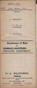
Document - H.A. & S.R. WILKINSON COLLECTION: CONTRACT OF SALE
Conditions of sale by private contract dated 30th March, 1932 between A. McKinnon (seller) and P. Thompson (buyer) for land situate in Murphy Street, Bendigo being the balance of the subdivision unsold of Crown allotment 151,270A, 271A, 271C, 271R, 195, 196, 270C, 271B and 271D described in certificate of title volume 2666 folio 533101, and being the land at present occupied by the vendor, not including the allotments or read showed on plan of subdivision. Together with weatherboard dwelling and all sundry including galvanized iron tank and stand, water trough and loose timber in paddock but does not include any window or verandah blinds. Price 800 pounds.organization, business, h.a. & s.r wilkinson real estate -
 Bendigo Historical Society Inc.
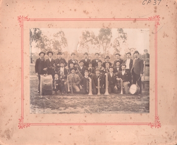
Photograph - EAGLEHAWK BOROUGH BRASS BAND 1896
Sepia photograph of brass band, (mounted on cream board with printed red border). Band on oval (paddock) with scattered trees and fence in background. Twenty adult males, two boys in group. Six kneeling, seven seated and remainder standing with various instruments with drum inscribed BBB 1896. Inscriptions: on front - 'GP37'. Back - J ? Oswald, 53 Peg Leg Road, Eaglehawk. On back, rubber stamp 'Royal Historical Society of Victoria, Bendigo Branch'. History: (HJG Biggs) Borough Brass Band 1896, Eaglehawk. Eaglehawk Borough Brass Band in 1896 with its preponderance of Cornish members (BHS Inc). Previous Acc. No. GP 37.person, group, band -
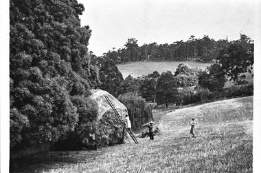 Southern Sherbrooke Historical Society Inc.
Photograph - Hay being stacked at Glen Park Farm, Selby
B&W photo showing hay being stacked at Glen Park Farm, Selby. The photo shows two women and a man in a sloping paddock. On the left is a woman in a pale, knee-length dress, climbing a ladder propped up against a tall haystack. The haystack has a covering with a repeated logo on it. A man stands near the bottom of the ladder, holding a sheaf of hay on his right shoulder. He is wearing a hat, light jacket and dark trousers. A woman stands uphill of the others. She has a light blouse and slightly darker calf-length skirt. The haystack is set between trees on the downhill side. In the distance Black Hill can be seen. -
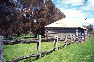 Ballarat Heritage Services
Photograph - Photograph - Colour, Clare Gervasoni, Carisbrook Police Lockup, c1998, c1998
The Logs at Carisbrook was the major gaol in the extensive Carisbrook Police District until 1858, and remained Carisbrook's gaol for low key offenders until about 1900. The lockup was registered by the National Trust on 22/10/1964.Colour photograph of the Carisbrook Police Lockup The Police staton was originally known as the Loddon Punt opening in 1851. The lock up was completed in October 1854 by James Corbet at a cost of 380 pounds. Standing in the park beside Bucknall Street it is the town's one significant historic building. It was originally built on the police paddock adjacent to the primary school and moved to its present site in 1886. The walls are made of interlocking horizontally-laid logs. The shingle roof has been replaced with corrugated iron. The lockup was built on site from local materials, and opened in 1851. It was moved to its current position ofter the original locationn flooded. The police station was closed in 1941. carisbrook, carisbrook lockup, carisbrook police lockup, log cabin, police, police paddock, the logs