Showing 954 items
matching bluestone%20buildings
-
 Melton City Libraries
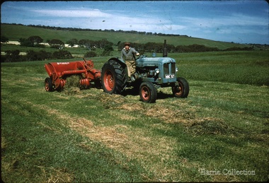
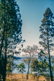
Photograph, Harvesting, 1960-1961
Jim was the youngest child of Charles Ernest Ernie Barrie “Darlingsford” of the farming family property Melton 1911. He was the brother of Ernest Wesley Bon, Charles Edgar, Thomas Lindsay. The family connection with this original property remained until the last part of the E W Barrie section was sold in 1982. Jim’s parents were Charles (Ernie) and Jessie Barrie of Darlingsford Melton. Tom farmed the family property with his father and brothers, and later the Ferris Road property which continued with his son Ian. His childhood interest in horses began with the draft horses kept at the bluestone stable and barn at Darlingsford. When the stables were empty in the late 1980s visit, he vividly recalled the names of the horses he had handled in his youth. When the draft horse became obsolete with the introduction of tractors and trucks this interest continued with the breeding and training of harness racersTom Barrie's harvest and Jim Barrie at Shelfordlocal identities, agriculture -
 Nillumbik Shire Council
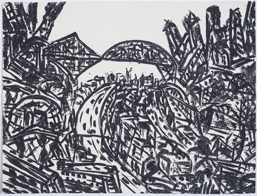
Print (sugarlift etching): Jan SENBERGS (b.1939 Lativia, arrived AUS 1950), Jan Sensbergs, 'New Jersey - rust belt' from the 'Baldessin & Friends' commemorative folio, 2016
Jan Senbergs was born in Riga, Latvia, in 1939 and came to Australia when he was ten. Senbergs’ work has been characterised by a simple and bold aesthetic. From lush landscapes to barren urban spaces, his body of work signifies an artist who has continually experimented with shape, form and motif, a fundamental humanist vision, a finely-honed sense of the absurd, and a rigorous studio practice spanning printmaking, drawing and painting. Senbergs is Baldessin's exact contemporary. He was also born in Europe and fled his homeland because of the war, arriving in Melbourne in 1950. Like George, Senbergs also worked at the RMIT and in 1973 represented Australia at the Bienal de Sao Paulo. Senbergs first met George when he was living in St. Kilda. George asked if he could screen print his 'Argus' catalogue for a show at the gallery in the Argus building. George Baldessin (1939-1978) was born in San Biagio di Callalta, in the Veneto in Northern Italy and arrived in Australia ten years later. A printmaker and sculptor he built his bluestone studio at St Andrews (Nillumbik) in 1971. The bluestone studio was hand built by George, his partner Tess and the three Hails brothers, Rob, Doug and Don. Made of recycled materials the studio today contains all of George’s equipment including the large press, which he modelled himself with the help of Neil Jeffrey (Enjay Presses). George won many prizes throughout his career and is represented in many of Australia's public art collections including his famous 'Pears' sculpture in front of the National Gallery of Australia, Canberra. In 1975 he represented Australia in the Sao Paulo Biennale, before living and working in Paris until his return to St Andrews in 1977. In 1978 George was killed in a car accident aged 39 years. In 2001 Tess returned to St Andrews to reclaim the run-down studio and reconstitute it as The Baldessin Press & Studio - a printmaking retreat. It operates in George’s memory, so that artists may continue to create, perpetuating the generous spirit of George.'New Jersey - rust belt' is one of eight prints in the 'Baldessin & Friends commemorative folio. The folio was conceived by Tess Edwards as a fundraising initiative in celebration of the The Baldessin Press & Studio's fifteen year anniversary, and as a way to honour George Baldessin's memory. The Baldessin Press & Studio is a not-for-profit organisation created in memory of the late George Baldessin (1939-1978), whose original studio is now open to the public for creative use and as a practical legacy to living artists. The Studio is located in St Andrews, Nillumbik. The folio is a unique coming together of seven very different and acclaimed artists who are connected by their friendship to the missing eighth member, George Baldessin. This print finds its' origins in the time Senbergs spent at Harvard in America in 1989-90. In the context of Baldessin it explores an industrial urban surreal vision that was common to both artist. The image captures the life force of the city revealing the keen and observant eye of Jan Senbergs. Similar in sensibility to his large scale charcoal drawings of the 1990s, the artwork is not only a record of what the artist sees, but of what interest him. By following the movement of each line the viewer can witness the artist's eye travelling through, over and around each element of the urban landscape. The scale is deceptive with the image bled to the full-size of the sheet of paper like a microcosm of a much bigger whole. sugar lift etching of an urban (cityscape - New Jersey) scene - bridges, roads, buildings, in thick black brushstrokes. The image is busy; full of energy and movement. A bleed print in which the paper barely contains the city scape. In pencil (handwritten): top centre: left '14/25' (edition); centre 'New Jersey-Rustbelt' (title); right 'Jan Senbergs' (signature); print, sugarlift etching, urban landscape, ekphrasis2018, new jersey, line, rust belt -
 Mortlake and District Historical Society
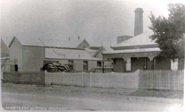
Mortlake Butter Factory Co. Ltd, Photograph
This local factory was typical of small butter factories in the 1890's in Western Victoria. It was established in 1894 when farmers brought their milk to the factory on horse drawn drays and carts and waited for their cream to be separated. The skimmed milk was mostly used by farmers to feed calves and pigs and the separated cream was manufactured into butter, some of which was exported to England. By 1910 this butter factory had an electricity generating plant called Mortlake Electricity which supplied both the factory and the township with power and this took precedence over the butter production which continued until 1926 when it was sold to the Electricity Commission. By 1930 the Butter Factory had a yearly turnover of 24,000 pounds sterling and in1935 it was producing 6 tons of butter weekly. But in 1936 the factory was sold to Glenormiston Cheese & Butter Factory who ceased operations. The manager's residence still remains in 2011 as does the remnants of the small timber butter factory (charcoal lined) and the double brick cheese room but the bluestone chimney has long gone. This complex is listed by Heritage Victoria Black and White Photograph Nonecheese factory, mortlake, butter factory -
 Victoria Police Museum
Police stations (Aitken's Gap)
Aitken's Gap, otherwise known as The Gap or Buttlejork, and 3km west of Sunbury, was established as a township in 1845. It is in the area which is now bordered by the Calder Highway and Gap Road. The village was named after John Aitken, a Port Phillip pastoralist who took up the Mount Aitken run in 1836. Aitken's Gap Police Barracks (in the District of Bourke) opened in 1853 and was staffed by two Mounted Constables and one Foot Constable. The gaol (used to house prisoners and also gold en route to Melbourne) was built in 1857 from bluestone quarried in the area. The roof was made of slate. In 1861 it was staffed by 1 Mounted Senior Constable and 1 Foot Constable. The Barracks closed in 1863 when the Bendigo rail line was completed and the gold was transported to Melbourne by rail. All the buildings, except the gaol, were moved to Sunbury. The land was sold in 1870 and in 1989 the current owner donated the building to the Sunbury Police. The original building was dismantled, restored and rebuilt outside Sunbury police station.15 colour photos and 1 black and white photopolice stations; aitken's gap police station -
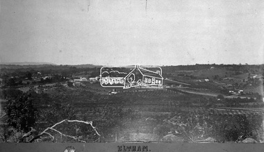 Eltham District Historical Society Inc
Negative - Photograph, Eltham, Vic, c.1890
View looking northeast from present day Ely Street (near intersection of present day Cronus Court and Porter Street) across what will become the site of Eltham High School towards Main Road showing the Eltham Courthouse and Police station. View is very similar to the sketch of Eltham published in 'The Illustrated Australasian News', December 26, 1884, p212. Note the large bluestone cell block behind police house and stable. George Knapman's Shoeing Forge next to the courthouse and the concentration of buildings around the Evelyn Hotel and Watson's Eltham Hotel on opposite sides of Main Road at Pitt street. Also note George Stebbing's cottage (c.1860) on Pitt Street behind the courthouse and 'Sunnyside' (home of W.J. Taylor built c.1885) at the top of the hill on Bible Street. In the foreground are orchards running up to the main street, Maria Street and also between Brougham Street and Dalton Street bordered by Bible Street.This photo forms part of a collection of photographs gathered by the Shire of Eltham for their centenary project book,"Pioneers and Painters: 100 years of the Shire of Eltham" by Alan Marshall (1971). The collection of over 500 images is held in partnership between Eltham District Historical Society and Yarra Plenty Regional Library (Eltham Library) and is now formally known as the 'The Shire of Eltham Pioneers Photograph Collection.' It is significant in being the first community sourced collection representing the places and people of the Shire's first one hundred years.Digital image 4 x 5 inch B&W Negshire of eltham pioneers photograph collection, eltham, 1890, bible street, brougham steet, dalton street, eltham courthouse, eltham hotel, evelyn hotel, franklin street, grant house, knapmans forge, main road, maria street, orchards, police residence, police station, pre 1900, stebbing cottage, sunnyside, w.b. andrew corn store, watsons hotel, little eltham -
 Flagstaff Hill Maritime Museum and Village
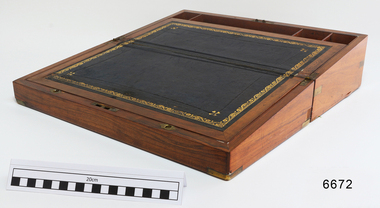
Domestic object - Writing Slope, early 20th century
In the words of the donor, Betty Stone, "This fitted writing slope box belonged to Ellis Dale of “Latrigg”, Wangoom, Warrnambool, and has an inscription “E. Dale”, hand written by Ellis on a small brass plaque featured on the lid. Ellis Dale, born 21 November 1860, was the second son of William and Elizabeth Dale, of Dale Bluestone Quarries Wangoom. He worked with his father at the quarries, and continued, after his father's death, to operate the family business with his son lvor until he died, aged 79 years, on 2 August 1940. Although the tradition was that the writing box was originally owned by Ellis's father, William Dale, there is some doubt that he brought it with him from England when he migrated in 1852 - however, we do know that it is at least one hundred years old. (Note: For additional information please refer to my book “Pioneers and Places - A History of three Warrnambool Pioneering Families” ie. Chamberlain, Dale and Lees Families)This item is associated with the Warrnambool pioneer families of Chamberlain, Dale and Lees. These families are listed in the Pioneers' Register for Warrnambool Township and Shire, 1835-1900, published by A.I.G.S. Warrnambool Branch. The item is significant for its association with a ‘glory box’ or hope chest’, a tradition of single ladies making and collecting a range of linen and other domestic items in preparation for their future marriage.Polished wooden Writing Slope or Travellers Desk. Owned by Ellis Dale. Box opens to be a sloped writing desk, with a leather writing surface decorated with a gold leaf border, and several compartments; one has a slightly concaved cover that pivots to open. Leather-covered boards hinge at the centre, and both sides lift, revealing further storage. Brass protectors on top corners, inlaid brass strengthening supports on two corners. Brass slide-releasing catches secure writing base as desk closes. The brass shield centre of the lid is engraved. Part of the 'Chamberlain Dale Lees Collection.Engraved shield on lid "E.Dale / Wangoom"flagstaff hill, warrnambool, shipwrecked coast, flagstaff hill maritime museum, maritime museum, shipwreck coast, flagstaff hill maritime village, great ocean road, chamberlain, dale, lees, stone, betty stone, warrnambool pioneers, writing slope, writing box, traveller's desk, portable desk, lap desk, ellis dale -
 Glenelg Shire Council Cultural Collection
Photograph - Photograph - Cape Grant Quarry, Portland, 03/08/1953
Port of Portland Authority Archives. From the Port of Portland website: Just 6km south of Portland, the Cape Grant Quarry is located on the eastern cliff of Cape Sir William Grant. This cape represents the core of a volcanic complex between two collapse calderas which underlie Nelson and Grant Bays to the west and east respectively. The Cape Grant quarry supplied an inexhaustible quantity of bluestone for the building of the new Portland harbour. The first stone was tipped at the root of the main breakwater on 17 November 1952. A small band of interested citizens were there to see the historic event. In the building, the breakwater was consolidated by the heavy traffic of Euclid’s and bulldozers and was further solidified by several storms that swept over it. Nowadays, blasting at the quarry is heavily regulated and carried out under the instructions of a qualified “powder monkey.” The days of seeing large explosions, along with the deep long loud BOOM are long gone with techniques of controlled blasting now improving overall environmental and safety standards.Front: Back- Purple PHT Stampport of portland archives, cape grant quarry, harbour development, construction -
 Kew Historical Society Inc
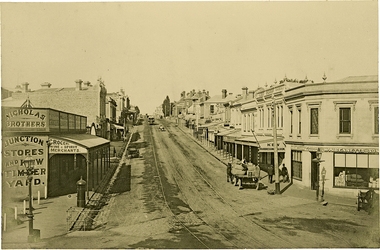
Photograph, J F C Farquhar, High Street, Kew, 1891
At the beginning of the 1890s, the Kew businessman and Town Councillor, Henry Kellett, commissioned J.F.C. Farquhar to photograph scenes of Kew. These scenes included panoramas as well as pastoral scenes. The resulting set of twelve photographs was assembled in an album, Kew Where We Live, from which customers could select images for purchase.The preamble to the album describes that the photographs used the ‘argentic bromide’ process, now more commonly known as the gelatine silver process. This form of dry plate photography allowed for the negatives to be kept for weeks before processing, hence its value in landscape photography. The resulting images were considered to be finely grained and everlasting. Evidence of the success of Henry Kellett’s venture can be seen today, in that some of the photographs are held in national collections.It is believed that the Kew Historical Society’s copy of the Kellett album is unique and that the photographs in the book were the first copies taken from the original plates. It is the first and most important series of images produced about Kew. The individual images have proved essential in identifying buildings and places of heritage value in the district.In 1891, High Street was the centre of commercial activity in the Borough of Kew. It was unpaved and edged with deep bluestone gutters, which were designed to channel the significant flow of storm water down the hill to and beyond the Junction. On either side of the entrance to the shopping strip are two cast iron gas lamps that provided the only public street lighting before the Post Office was reached. Most shops, including the Nicholas Brothers’ Junction Store featured cast iron verandas. Further up the hill, Dougherty’s Greyhound Hotel was by this stage a local institution. Apart from the horse-drawn tram, the main form of personal and commercial transport in this period remained the horse, horse and cart, or buggy.The panoramic view predates the widening of High Street in the 20th century, and thus includes the original alignment of buildings on the south side. These included Henry Kellett’s shop.High Street, Kewkew illustrated, kew where we live, photographic books, henry kellett, high street - kew (vic) -
Glenelg Shire Council Cultural Collection
Photograph - Photograph - 'Stanton Drew', Portland, n.d
Stanton Drew was a two storey stucco rendered bluestone house was constructed in 1864 for Major Alexander Davidson, a Scottish born pastoralist who had earlier in 1848 settled on the Wando River near Casterton. Stanton Drew is a characteristic pattern book, regency gothic villa and virtually devoid of ornamentation save for unusually fenestrated bay windows and window label mouldings. Stanton Drew is a late example in Victoria of the primitive regency gothic style of villa architecture popularised by pattern books of the period 1840-60. The two storey house is an undistinguished design most notable for its associations with Western District pastoralist Alexander Davidson. No important historical associations are apparent, although the Davidson family lived in the residence until c.1908. Stanton Drew is in an extremely dilapidated state and has suffered badly form subsidence and lack of regular maintenance. The slate roof has been replaced with iron. The house was originally named Wando Villa by Davidson in memory of his time at Wando River. The house was renamed in 1938.Black and white photo. View of the front of 'Stanton-Drew' house, Portland.Back: 'STANTON-DREW, PORTLAND, VICTORIA, 1971' -handwritten black biro. Purple stamp 'ALEX PRIESTLEY BOX 155 PHONE 309 HEYWOOD VIC 3304'historic homestead, bluestone building, alexander davidson, pastoralist -
Unions Ballarat
Camp Street, Ballarat from Eureka to Federation : a guide to its history and buildings, 2001
A guide to the history of Camp Street Ballarat and its historical buildings. Camp Street has been the location of Unions Ballarat since 1887 - a chapter of the book is dedicated to Trades Hall - and was the home of the former labour newspaper, the Evening Echo. Camp Street was the site of the government camp at the time of the Eureka Stockade. Camp Street is now recognised as an Arts and Education precinct within the city of Ballarat. Headings: Gold fever The CAMPSTREET Project Titanic Bandstand Old Ballarat Free Library Complex "Point to the sky" "Perseus" Former government offices and court house Old Ballarat Court House Alfred Deakin Place Old Police Station (Ballarat Fine Art Gallery) Ballarat Fine Art Gallery Millennium Extension Bluestone Warehouse (Pratt's Warehouse) Old YMCA building Wilson House Ballarat Office Systems Ballarat Trades Hall The ANA Building Freemason's Hall Former Ballarat Trustees and Executors Agency Co. Ltd. Restaurant Former Evening Echo Building Ballarat Savings Bank (now The Ballarat Business Centre) Significant to the history of architecture and social life within the city of Ballarat. Direct relevance to Unions Ballarat building.Book; 48 pages. Cover: blue background; colour photos and maps pertinent to Ballarat; white lettering; title and compiler's name. btlc, ballarat trades hall, ballarat trades and labour council, evening echo, ballarat savings bank, ballarat business centre, freemason's hall - ballarat, ana building - ballarat, ballarat - camp street, wilson house - ballarat, ballarat office systems, ymca building, pratt's warehouse - ballarat, ballarat fine art gallery, old police station - ballarat, alfred deakin place, old courthouse - ballarat, perseus, point to the sky, old ballarat free library complex, titanic bandstand, campstreet project, gold mining - ballarat, architecture - history - ballarat -
 Melton City Libraries
Photograph, Myers family members at Uniting Church, 1986
The Uniting Church (originally the Scots Presbyterian Church) was built 1865-67) and adjacent former Church Hall / Sunday School (built 1938), Yuille Street, Melton. The adjacent former church hall, now kindergarten facility. The Uniting Church and former church hall are historically significant at a Local level (AHC A4). It was built after Melton’s ‘United’ church and school, erected by Protestant denominations in 1857 in an effort to share resources in the pioneering era, was replaced by individual churches in the 1860s. The church became the home of and is expressive of the union of the Methodist and Presbyterian churches, begun in Melton from the early 1970s, and formally concluded by the formation of the Uniting Church of Australia in 1977. The new additions and functions of the church are expressive of the increase in Melton’s population especially in the 1970s, and the changing nature of the parish’s ministry. The church is one of only three remaining nineteenth century churches, and one of only two remaining bluestone churches, in the Shire of Melton. Information from Shire of Melton Heritage Study Stage 2 Volume 6 David Moloney 2007 At the opening of the new extension to the churchlocal identities, churches -
Mortlake and District Historical Society
Mt. Shadwell Bush Inn, photograph
This Mount Shadwell Bush Inn erected in 1854 was situated adjacent to one of the main routes to the diggings (Great Western Road), and was originally built from tufa stone obtained from a local quarry. It did a great trade after if first became licensed ub 1855, when it provided a valuable service to the travelling public and to the increasing agricultural population of the area. At that time it contained three sitting rooms, several large reception rooms, fourteen bedrooms, a bar and two taprooms and was the first known hostelry in Mortlake. In 1863 a bluestone addition (probably done by local architect Andrew Kerr) increased the size of the hotel to 23 rooms with a detached billiard room and ballroom, kitchen, servant's apartments, laundry, storeroom, 12 stalled stable, out office, and stock yards for travelling cattle. The present hotel with its 1928 rendered facade, has had an almost uninterrupted licence since 1855 -
 Federation University Historical Collection
Document - Documents, Golden Point - Mount Pleasant Progress Association Establishment
The Golden Point - Mt Pleasant Progress Association was established on Wednesday 6 April 1983. Membership was open to any person or organisation in the area generally bounded by Bridge mall and Skipton Street, Elsworth Street and main Road. annual family or organisation membership was $2.00. Mara Gluyas served as secretary of the Golden Point - Mt Pleasant Progress Association from 1983 to 1994. Ian McKinnon was the President from 1983 to 1992. Kerry Daniels was the President in 1994.A small white cardboard box with purple lid of A4 documents relating to the establishment of the Golden Point - Mt Pleasant Progress Association. The documents include the original constitution and minutes. Topics include: Pearce's Park; removal of elms, names and addresses of members, Sovereign Hill realignment; Sovereign Hill Lookout; membership form; Golden Point Historic Mines Direction Indicator; Ballarat Observatory; Nerrina Tip; Yarrowee Creek; Mine Capping (Sovereign Mine); tree planting (Sovereign Hill Lookout); Magpie Street Park; Hill Street; Yarrowee Flora Park; Barkly Street; South Street Bluestone Gutter; Ballarat Goldfields; Eastern baths site; Grant Street; Flooding; Aboriginal Advancement League; Sunnyside Woollen Mill; Chinese Garden; Golden Point Primary School closure; Ballarat West Goldfields; Sovereign Hill Land Title and Management Revision; Wainwright; Street; Llanberris; Yuille's Station Parkgolden point, mount pleasant, mt pleasant, ian mckinnno, mara gluyas, peter hiscock, frank williams, geoff howard, leigh gillett, sovereign hill, kerry daniels, norm strange; graeme kent; george netherway; keith rash; ian mckinnon, albert graham, bryan crebbin, jim humphreys. wid radbourn, heath martin, janet dore, alex mills park -
 Ballarat Heritage Services
Photograph - Photograph - Colour, Clare Gervasoni, Koroit Post Office, 2015, 21/12/2015
The town borrows its name from the Koroitch Gundidj people who occupied the area prior to European settlement. (https://en.wikipedia.org/wiki/Koroit, accessed 21 December 2016) Koroit was first surveyed as a township in 1847. Around the 1850 the district had the highest population of Irish immigrants in rural Australia. The Koroit Post Office was designed by architect and engineer John Mason of Port Fairy. (Moyne Shire Heritage Study 2006 Stage 2, Volume 2: Environmental History, Prepared for Moyne Shire Council Helen Doyle in association with Context Pty Ltd, 2006.) Rosebrook Bridge, Rosebrook (1853; replaced) Post Office buildings, Bank Street, Port Fairy (c.1857) The author Henry Handel Richardson lived in the Koroit Post Office as a child after her family moved to Koroit in 1878. Remembering Koroit from her youth, the third volume in her The Fortunes of Richard Mahony trilogy is set in the town. When the author was six, her father Walter died in Koroit on 1 August 1879 and was buried at the Koroit cemetery. (https://en.wikipedia.org/wiki/Koroit, accessed 21 December 2016) In 1878 Mary Richardson was appointed postmistress of the Koroit Post Office at a salary of 72 pounds with free quarters, firewood and kerosene. She lived at the back of the Post Office. (From a Green and Pleasant Land by H. McCorkell and P. Yule.) Photographs showing the bluestone Koroit Post Office, phone box and postbox. It is located at 99 Commercial Road, Koroit. "Historic Area Statement of Significance: The significance of Koroit derives from its role as the urban centre of one of the most concentrated Irish Roman Catholic rural districts in Australia, noted for its mixed livestock and cropping argicultural patterns. This is reflected in two separate and distinctive areas in the town - the administrative/commercial area and the church precinct. The administrative and commercial area (focussing on the Boundary-Commercial Road/High Street intersection and the Koroit Hotel) consists of a number of significant public buildings and leads to a street of relatively intact humble shopfronts and kerbline verandahs, visually punctuated by opposing bank facades. The church precinct is dominated by a group of Catholic buildings larger in scale and more complete in range than those in any comparably sized Victorian town." http://vhd.heritagecouncil.vic.gov.au/places/69338#sthash.ELLuSMvg.dpuf, accessed 21 December 2016."koroit, post office, phone box, payphone, bluestone, henry handel richardson, koroit post office -
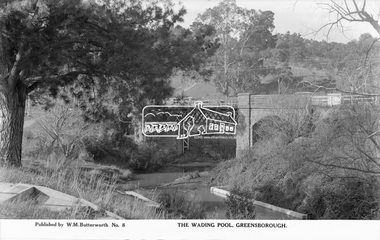 Eltham District Historical Society Inc
Photograph, The Rose Stereograph Company, The Wading Pool, Greensborough, c.1939
View looking northeast across the wading pool set into the Plenty River towards the original bluestone Greensborough Bridge (since demolished). A timber pedestrian footbridge added after construction is visible on the far side of the bridge through the arch and beyond to the hillside which is now present day Pioneer Reserve. This glass plate negative was used to manufacture postcards (1:1 printing) for commercial sale by the Rose Sterograph Company and its subsidiaries. George Rose founded the Rose Stereograph Company in 1880 and was joined by Herbert (Bert) Cutts in the early 20th Century. The pair formed a lifetime working partnership and strong personal friendship. Assisted by George’s two sons, Herbert George and Walter, and later by Neil Cutts, the Rose Stereograph Company continued its operations for more than 140 years. The company was initially built on stereographs, but as cinema took over and stereographs fell out of fashion, the Rose Stereograph Company developed Australia’s first commercially viable photographic postcard business. Specialising in postcards of iconic historical moments and significant landmarks, The Rose Stereograph Company became a staple of the Australian travel industry.This remarkable collection of glass plate negatives, transparencies, and postcards – arguably Australia’s most significant photography collection outside of public hands – has been passed down through the generations, surviving war, relocation, and the harsh Victorian climate. The historic Rose Stereograph collection is the culmination of George Rose’s dream of capturing and preserving precious moments in time and remains the legacy of the Rose and Cutts families. It is with great sadness that the Cutts family says goodbye to a collection that spans five generations and 140 years. The Cutts family understands that for these historically important pieces to rest with one family is to deny others the pleasure of their custodianship.Glass Plate Negative Size: 9.1 x 14 cmThe Wading Pool, Greensborough, Published by W. M. Butterworh No. 8postcard, travel, rose stereograph company, glass plate negative, greensborough, footbridge, greensborough bridge, main road, plenty river, w. m. butterworth, pioneer reserve, wading pool, peter and elizabeth pidgeon collection -
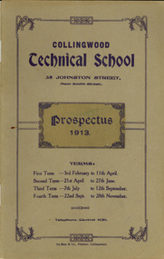 Federation University Historical Collection
Booklet, Collingwood Technical School Prospectus, 1913, 1913
In the early years of the 20th century adequate technical education was lacking and became a focus in the Victorian Parliament. After much debate and discussion among politicians and educationalists, the 1910 Education Act No 2301 was passed, making possible the establishment of new technical schools to address the dearth of skilled trades people. In July 1912 Collingwood Technical School opened in the modified bluestone buildings at 35 Johnston St, originally built in 1853 as the Collingwood Town Hall and Court House. Within three weeks, there were 57 boys enrolled - studying preliminary carpentry and pattern-making, plumbing, engineering, sheet iron work and bricklaying. They attended two hours a night on three evenings a week. In 1913, the school opened its doors to juniors and took residence in new permanent buildings erected on the site. It was classified as a trades school by the State Education Department. Two years later courses in electrical wiring and electrical and mechanical engineering were introduced. In 1988 Preston College of TAFE and Collingwood College of TAFE merged to become Northern Metropolitan Institute of TAFE (NMIT). (http://victoriancollections.net.au/organisations/northern-melbourne-institute-of-tafe)Brown soft covered booklet of 40 pages. The contents include information relating to the Collingwood Technical School on 1913, including: Council members, constitution, standing orders, aim of the school, scholarships, advice to parents, Railway Fares, tram fares, General Rules to Students, Syllabus, English, Geography, Civics, Mathematics, Elementary Science, Woodwork, |Sheetmetalwork, evening course, carpentry, plumbing, joinery, and a list of students for 1912 Evening courses. collingwood technical school, collingwood, tafe, nmit, northern metropolitan institute of tafe -
 Federation University Historical Collection
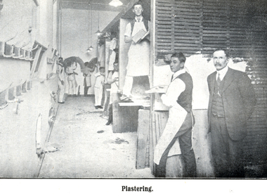
Booklet, Collingwood Technical School Prospectus, 1914, 1914
In the early years of the 20th century adequate technical education was lacking and became a focus in the Victorian Parliament. After much debate and discussion among politicians and educationalists, the 1910 Education Act No 2301 was passed, making possible the establishment of new technical schools to address the dearth of skilled trades people. In July 1912 Collingwood Technical School opened in the modified bluestone buildings at 35 Johnston St, originally built in 1853 as the Collingwood Town Hall and Court House. Within three weeks, there were 57 boys enrolled - studying preliminary carpentry and pattern-making, plumbing, engineering, sheet iron work and bricklaying. They attended two hours a night on three evenings a week. In 1913, the school opened its doors to juniors and took residence in new permanent buildings erected on the site. It was classified as a trades school by the State Education Department. Two years later courses in electrical wiring and electrical and mechanical engineering were introduced. In 1988 Preston College of TAFE and Collingwood College of TAFE merged to become Northern Metropolitan Institute of TAFE (NMIT). (http://victoriancollections.net.au/organisations/northern-melbourne-institute-of-tafe)Red soft covered book of 60 pages. Contents include: List of President, Council and staff, constitution, aim of the school, scholarships, evening classes, advice to parents, Railway fares, tram fares, free travel, general rules for students. syllabus of work, evening work. Images include carpentry class, Bricklaying, plastering and Turning & Fitting classcollingwood technical school, collingwood, tafe, nmit, northern metropolitan institute of tafe, carpentry, bricklaying, plastering, turning and fitting -
 Federation University Historical Collection
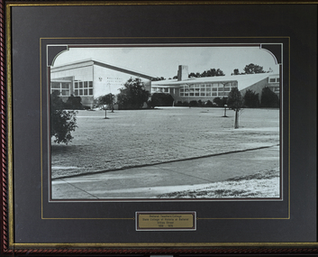
Photograph - Framed photograph, Ballarat Teachers' College Gillies Street
These images were hung in the corridor of the University of Ballarat School of Education (Mount Helen). It most probably dates from around the time of the transfer of the College. The Ballarat Teachers' College was established after the Victorian State Government and the State Education Department decided to establish two provincial teachers' colleges, at Ballarat and Bendigo. On 04 May 1926 W.H. Ellwood (Principal), Miss A. Bouchier, and Mr A.B. Jones, welcomed the first enrolment of 61 students to undertake the one year course. In 1927 the College moved to the former Ballarat East Town Hall in Barkly Street, which was remodelled for their use. It closed in December 1931 due to the Great Depression. In 1946 Ballarat Teachers' College reopened and relocated to the Dana Street State School. The building used by the Teachers' College was the original bluestone building facing Doveton Street South. It was originally planned to open as a women's college, for whom the residence at 130 Victoria Street was purchased, but the decision was made to admit resident men from Ballarat. Mr T.W. Turner was appointed as Principal in 1951 and directed the introduction of a two year course for the Trained Primary Teachers' Certificate. The former one year course was terminated at the end of 1951. In 1958 the College was relocated to a custom built facility at Gillies Street, in close proximity to the Ballarat Botanical Gardens. Numbers increased with the introduction of the Trained Infant Teachers' Certificate course under the guidance of Mary Egan. With the introduction of a three year Diploma Course in 1968 accommodation became cramped. The introduction of the Diploma of Teaching (Primary) led to the Trained Infant Teachers' Certificate being discontinued in 1969, and the end of the Trained Primary Teachers' Certificate in 1969. Secondary Art and Craft students began studies at Ballarat Teachers' College in 1969 under Mr Ted Doney. In 1971 Mr D. Watson was appointed Principal. The State College of Victoria was proclaimed by Order in Council on 24 July 1973, and Ballarat Teachers' College became a constituent college of the State College of Victoria, and was known as State College of Victoria, Ballarat. By 1975 the College moved to Mount Helen as part of the Ballarat College of Advanced Education. Pre service teachers currently undertake their studies on the Mount Helen Campus of Federation University. ("Ruffians Attempted to Carry of the School Tent: A History of State Education in Ballarat", 1974, p73-4.) This image was hung in the corridor of the University of Ballarat School of Education (Mount Helen). It most probably dates from around the time of the transfer of the Ballarat Teachers' College from Gillies Street to the Mount Helen Campus of the Ballarat College of Advanced Educaiton. The building used by the Teachers' College was the original bluestone building facing Doveton Street South.Framed black and white photography with green mount. The photo shows the Ballarat Teachers' College Gillies Street building. ON plaque 'Ballarat Teachers' College, State College of Victoria at Ballarat, Gillies Street, 1958-1976education, ballarat teachers college, gillies street, 00607 -
Glenelg Shire Council Cultural Collection
Book, People of the Lake - the story of Lake Condah Mission, n.d
27,000 years ago molten lava pouring from the eruption of Budjbim (Mt. Eccles) formed Lake Condah and the unique landscape that surrounds it. Over time this area known as "The Stony Rises" or "The Stones" became an important geological area for Koories and, later, Europeans.12 page A4 size booklet, cream with brown print.27,000 years ago molten lava pouring from the eruption of Budjbim (Mt. Eccles) formed Lake Condah and the unique landscape that surrounds it. Over time this area known as "The Stony Rises" or "The Stones" became an important geological area for Koories and, later, Europeans.aboriginal history, gunditjmara, lake condah, mission history, budj bim -
 Eltham District Historical Society Inc
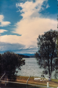
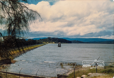
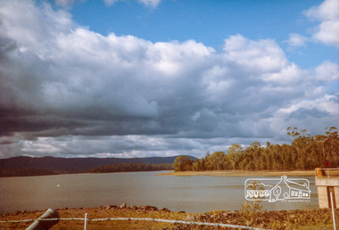
Photograph, Yan Yean, 1987, 1987
Originally contained in a 'magnetic' photo album of scenic photos of Yan Yean and Warrandyte believed to be donated by Mrs Eric Stephenson, Jingalong, 110 Ryans Road, Eltham, Vic. 3095; relocated to archival safe storage. On the 20th December 1853 Lieut Governor Charles LaTrobe took his spade to turn the first sod of an embankment across the swampy bed of the Plenty River at a lonely place called Yan Yean, in order to create Melbourne’s first water supply. In the early 1850’s water had been drawn from the Yarra which even then was known as Yarra Soup. A convict by the name of James Blackburn produced the basic design for supplying water to Melbourne from a reservoir on the Plenty River at Yan Yean, and later on he was appointed consulting engineer on the project. In 1853 a contract was let for the building of the wall for 91 thousand 575 pounds, and at one stage some 400 labourers were at work in the area. A tramway was constructed to convey stone and other materials from Melbourne. So famous was this magnificent stretch of water that illustrations of the bluestone embankment and tower appeared in London journals Whittlesea Historical Society – Historic items for Diamond Valley Community Radio September 1990 Colour photographyan yean, yan yean reservoir -
 Eltham District Historical Society Inc
Photograph, Yan Yean, 1987, 1987
Originally contained in a 'magnetic' photo album of scenic photos of Yan Yean and Warrandyte believed to be donated by Mrs Eric Stephenson, Jingalong, 110 Ryans Road, Eltham, Vic. 3095; relocated to archival safe storage. On the 20th December 1853 Lieut Governor Charles LaTrobe took his spade to turn the first sod of an embankment across the swampy bed of the Plenty River at a lonely place called Yan Yean, in order to create Melbourne’s first water supply. In the early 1850’s water had been drawn from the Yarra which even then was known as Yarra Soup. A convict by the name of James Blackburn produced the basic design for supplying water to Melbourne from a reservoir on the Plenty River at Yan Yean, and later on he was appointed consulting engineer on the project. In 1853 a contract was let for the building of the wall for 91 thousand 575 pounds, and at one stage some 400 labourers were at work in the area. A tramway was constructed to convey stone and other materials from Melbourne. So famous was this magnificent stretch of water that illustrations of the bluestone embankment and tower appeared in London journals Whittlesea Historical Society – Historic items for Diamond Valley Community Radio September 1990Colour photographyan yean, yan yean reservoir -
 Eltham District Historical Society Inc
Photograph, Yan Yean Reservoir
Originally contained in a 'magnetic' photo album of scenic photos of Yan Yean and Warrandyte believed to be donated by Mrs Eric Stephenson, Jingalong, 110 Ryans Road, Eltham, Vic. 3095; relocated to archival safe storage. On the 20th December 1853 Lieut Governor Charles LaTrobe took his spade to turn the first sod of an embankment across the swampy bed of the Plenty River at a lonely place called Yan Yean, in order to create Melbourne’s first water supply. In the early 1850’s water had been drawn from the Yarra which even then was known as Yarra Soup. A convict by the name of James Blackburn produced the basic design for supplying water to Melbourne from a reservoir on the Plenty River at Yan Yean, and later on he was appointed consulting engineer on the project. In 1853 a contract was let for the building of the wall for 91 thousand 575 pounds, and at one stage some 400 labourers were at work in the area. A tramway was constructed to convey stone and other materials from Melbourne. So famous was this magnificent stretch of water that illustrations of the bluestone embankment and tower appeared in London journals Whittlesea Historical Society – Historic items for Diamond Valley Community Radio September 1990 Colour photographyan yean, yan yean reservoir -
 Eltham District Historical Society Inc
Photograph, Yan Yean, 1988, 1988
Originally contained in a 'magnetic' photo album of scenic photos of Yan Yean and Warrandyte believed to be donated by Mrs Eric Stephenson, Jingalong, 110 Ryans Road, Eltham, Vic. 3095; relocated to archival safe storage. On the 20th December 1853 Lieut Governor Charles LaTrobe took his spade to turn the first sod of an embankment across the swampy bed of the Plenty River at a lonely place called Yan Yean, in order to create Melbourne’s first water supply. In the early 1850’s water had been drawn from the Yarra which even then was known as Yarra Soup. A convict by the name of James Blackburn produced the basic design for supplying water to Melbourne from a reservoir on the Plenty River at Yan Yean, and later on he was appointed consulting engineer on the project. In 1853 a contract was let for the building of the wall for 91 thousand 575 pounds, and at one stage some 400 labourers were at work in the area. A tramway was constructed to convey stone and other materials from Melbourne. So famous was this magnificent stretch of water that illustrations of the bluestone embankment and tower appeared in London journals Whittlesea Historical Society – Historic items for Diamond Valley Community Radio September 1990 Colour photographyan yean, yan yean reservoir -
 Eltham District Historical Society Inc
Photograph, Flowering Gum at Yan Yean, 1988, 1988
Originally contained in a 'magnetic' photo album of scenic photos of Yan Yean and Warrandyte believed to be donated by Mrs Eric Stephenson, Jingalong, 110 Ryans Road, Eltham, Vic. 3095; relocated to archival safe storage. On the 20th December 1853 Lieut Governor Charles LaTrobe took his spade to turn the first sod of an embankment across the swampy bed of the Plenty River at a lonely place called Yan Yean, in order to create Melbourne’s first water supply. In the early 1850’s water had been drawn from the Yarra which even then was known as Yarra Soup. A convict by the name of James Blackburn produced the basic design for supplying water to Melbourne from a reservoir on the Plenty River at Yan Yean, and later on he was appointed consulting engineer on the project. In 1853 a contract was let for the building of the wall for 91 thousand 575 pounds, and at one stage some 400 labourers were at work in the area. A tramway was constructed to convey stone and other materials from Melbourne. So famous was this magnificent stretch of water that illustrations of the bluestone embankment and tower appeared in London journals Whittlesea Historical Society – Historic items for Diamond Valley Community Radio September 1990 Colour photographyan yean -
 Federation University Historical Collection
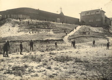
Photograph, Ballarat Junior Technical School - outside the Ballarat Gaol Wall, c1921
In February 1913 the Ballarat Junior Technical School opened its doors to its 86 pupils. The old bluestone building in the grounds of the Dana Street Primary School became their temporary home for eight years. In its early years the school offered only a two-year course. The first year was of a general nature giving a thorough grounding in Mathematics and Instrumental Drawing, and introducing students to the various branches of trade work. The second-year students studied for the Junior Technical Certificate and specialized in a course of their choice - either a trade (Woodwork or Fitting and Turning) or a course leading to higher studies at the School of Mines. Increased enrolment - 86 to 110 in the second year. Some applicants were turned away due to lack of space. An abandoned single room school was brought in and this helped for a time. Plans were developed and a two-storied red brick building in the vacinity of the School of Mines was build. An acre of land was reclaimed from the north-east corner of the Ballarat Gaol. The school backed onto the wall of the gaol. The task of landscaping and terracing of the area was to cost a great deal and time. The boys did much of the heavy work. This kept them occupied as the official playground areas were still full of rubble.View from the south-east of the Junior Technical School with the slope from the gaol wall down to the area known as the Battery Paddock. The new school building was a two-storied red brick building along the Education Department style of the 1920s. On 9 September 1921, the Junior Technical School building was officially opened. Much work was needed to terrace and landscape the area. Students shown in various areas of the grounds.junior technical school, dana street primary school, bluestone, mathematics, instrumental drawing, junior technical certificate, woodwork, fitting and turning, school of mines, ballarat gaol, landscaping, terracing, gaol wall, cricket -
 Melton City Libraries
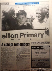
Newspaper, A school remembers, 1995
"On 17th May 1858 a State subsidised, combined Denominational School was opened by HT Stokes, with an attendance of about 30 children. This school was conducted in the wooden Melton Combined Protestant Church, situated on ‘a creek flat’ thought to be on the north side of Sherwin Street between Pyke and Byran Streets. It is likely that the Church had been established by 1855 and that the first minister was the Rev. Hampshire, who lived in Cambridge House on the Exford Estate. Ministers of the Protestant denominations were invited to hold services there. As there was only one resident Minister in the town (Presbyterian Mr J Lambie), laymen of the various denominations often spoke on Sundays. In 1863 this building was declared a Common School with the number 430. One of its first and most prominent headmasters was John Corr, who served from 1860 to 1864. Most of Mr Corr’s children also became teachers, including Joseph Corr, at the Rockbank school, and J Reford Corr and WS Corr, headmasters and teachers at numerous prestigious private secondary schools around Australia. John Corr purchased land alongside the school and elsewhere in and near Melton, became secretary and treasurer of the new Cemetery Trust, and by July 1861 was deputy registrar of births, deaths and marriages. He walked three miles every Sunday to teach at the Weslyan Sunday School he had established. Despite good reports from the Education Department Inspector, and burgeoning enrolments, the local school committee recommended the dismissal of, firstly, his wife (from the work mistress position), and then him from the headmaster position. Corr saw his dismissal as an attempt to redirect state aid for education from the Combined Protestant school to the support of the Free Presbyterian Minister Rev James Lambie (by one account the owner of the land on which the Common School was erected), whose son-in-law James Scott subsequently assumed responsibility for the school. Rev Lambie failed in his efforts to keep the existing school, which the Education Department Inspector and the majority of Melton citizens regarded as badly situated and badly built. Following a conditional promise of state aid, local contributors in 1868-69 raised ₤72.10.6 towards the cost of an iron-roofed bluestone rubble building 43 ft x 12 ft. This was erected on a new site of 1.5 acres (the present site). The State contributed ₤120 to the new school, which opened in 1870. A very early (c.1874) photograph of the school shows its headmaster and work mistress / assistant teacher (probably James Scott and his wife Jessie) and its (very young) scholars. Similar photos show pupils in front of the school in c.1903, and 1933. In 1877 a second bluestone room costing ₤297 was added and further land acquired from the Agricultural Society (who only needed it two days a year) to enlarge the schoolground to 3 acres. In the early 1880s an underground tank augmented the school water supply and in 1919 a five-roomed wooden residence was added. During this period the school correspondents often compained that the walls of the bluestone buildings were damp, affecting the plaster. In 1923 a brick room 26 ft 6 in by 24 ft with a fireplace and four rooms facing south, was added, and a corridor built to link the three buildings. This served adequately for the next 40 years. The school bell probably dates to 1883. The school also has a memorial gate (1951) to World War One ex-students, and an honour board to the 64 ex-students who served in the First World War. The school roll fell to 42 in the early post war-years, but was boosted by an influx of migrants, mainly from the UK, from the late 1960s. This presaged the boom in Melton’s development, and the corresponding growth of the school, with timber and temporary classrooms added to the previous masonry ones. An endowment pine plantation established in 1930 augmented the school’s fundraising activities when it was harvested in 1968. Part of the site was planted with eucalyptus trees in 1959. Famous ex-students of the early twentieth century included Hector Fraser (internationally successful shooter) and cyclist Sir Hubert Opperman". Photo of Edna and Margaret Barrie with Miles Baunders taken for the Telegrapheducation, local identities -
 Melton City Libraries
Memorabilia, Melton State School Centenary, 1970
On 17th May 1858 a State subsidised, combined Denominational School was opened by HT Stokes, with an attendance of about 30 children. This school was conducted in the wooden Melton Combined Protestant Church, situated on ‘a creek flat’ thought to be on the north side of Sherwin Street between Pyke and Byran Streets. It is likely that the Church had been established by 1855 and that the first minister was the Rev. Hampshire, who lived in Cambridge House on the Exford Estate. Ministers of the Protestant denominations were invited to hold services there. As there was only one resident Minister in the town (Presbyterian Mr J Lambie), laymen of the various denominations often spoke on Sundays. In 1863 this building was declared a Common School with the number 430. One of its first and most prominent headmasters was John Corr, who served from 1860 to 1864. Most of Mr Corr’s children also became teachers, including Joseph Corr, at the Rockbank school, and J Reford Corr and WS Corr, headmasters and teachers at numerous prestigious private secondary schools around Australia. John Corr purchased land alongside the school and elsewhere in and near Melton, became secretary and treasurer of the new Cemetery Trust, and by July 1861 was deputy registrar of births, deaths and marriages. He walked three miles every Sunday to teach at the Weslyan Sunday School he had established. Despite good reports from the Education Department Inspector, and burgeoning enrolments, the local school committee recommended the dismissal of, firstly, his wife (from the work mistress position), and then him from the headmaster position. Corr saw his dismissal as an attempt to redirect state aid for education from the Combined Protestant school to the support of the Free Presbyterian Minister Rev James Lambie (by one account the owner of the land on which the Common School was erected), whose son-in-law James Scott subsequently assumed responsibility for the school. Rev Lambie failed in his efforts to keep the existing school, which the Education Department Inspector and the majority of Melton citizens regarded as badly situated and badly built. Following a conditional promise of state aid, local contributors in 1868-69 raised ₤72.10.6 towards the cost of an iron-roofed bluestone rubble building 43 ft x 12 ft. This was erected on a new site of 1.5 acres (the present site). The State contributed ₤120 to the new school, which opened in 1870. A very early (c.1874) photograph of the school shows its headmaster and work mistress / assistant teacher (probably James Scott and his wife Jessie) and its (very young) scholars. Similar photos show pupils in front of the school in c.1903, and 1933. In 1877 a second bluestone room costing ₤297 was added and further land acquired from the Agricultural Society (who only needed it two days a year) to enlarge the schoolground to 3 acres. In the early 1880s an underground tank augmented the school water supply and in 1919 a five-roomed wooden residence was added. During this period the school correspondents often compained that the walls of the bluestone buildings were damp, affecting the plaster. In 1923 a brick room 26 ft 6 in by 24 ft with a fireplace and four rooms facing south, was added, and a corridor built to link the three buildings. This served adequately for the next 40 years. The school bell probably dates to 1883. The school also has a memorial gate (1951) to World War One ex-students, and an honour board to the 64 ex-students who served in the First World War. The school roll fell to 42 in the early post war-years, but was boosted by an influx of migrants, mainly from the UK, from the late 1960s. This presaged the boom in Melton’s development, and the corresponding growth of the school, with timber and temporary classrooms added to the previous masonry ones. An endowment pine plantation established in 1930 augmented the school’s fundraising activities when it was harvested in 1968. Part of the site was planted with eucalyptus trees in 1959. Famous ex-students of the early twentieth century included Hector Fraser (internationally successful shooter) and cyclist Sir Hubert Opperman. Pen, flag and flyer from the Melton State School Centenary celebrationseducation, local significant events