Showing 734 items matching "building blocks"
-
 The Beechworth Burke Museum Research Collection
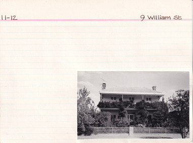
Card (Series) - Index Card, George Tibbits, 9 William Street, Beechworth, 1976
George Tibbits, University of Melbourne. Faculty of Architecture, Building and Town & Regional PlanningIndex system that support the research for Beechworth : historical reconstruction / [by] George Tibbits ... [et al]Arranged by street names of BeechworthEach index card includes: street name and number of property, image of property, allotment and section number, property owners and dates of ownership, description of the property according to rate records, property floor plan with dimensions.beechworth, george tibbitsbeechworth, george tibbits -
 The Beechworth Burke Museum Research Collection
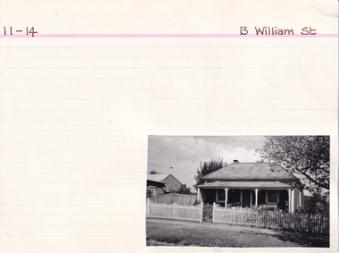
Card (Series) - Index Card, George Tibbits, 13 William Street Beechworth, 1976
George Tibbits, University of Melbourne. Faculty of Architecture, Building and Town & Regional PlanningIndex system that support the research for Beechworth : historical reconstruction / [by] George Tibbits ... [et al]Arranged by street names of BeechworthEach index card includes: street name and number of property, image of property, allotment and section number, property owners and dates of ownership, description of the property according to rate records, property floor plan with dimensions.beechworth, george tibbitsbeechworth, george tibbits -
 The Beechworth Burke Museum Research Collection
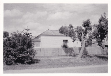
Card (Series) - Index Card, George Tibbits, 14 William Street Beechworth (cnr Last St), 1976
George Tibbits, University of Melbourne. Faculty of Architecture, Building and Town & Regional PlanningIndex system that support the research for Beechworth : historical reconstruction / [by] George Tibbits ... [et al]Arranged by street names of BeechworthEach index card includes: street name and number of property, image of property, allotment and section number, property owners and dates of ownership, description of the property according to rate records, property floor plan with dimensions.beechworth, george tibbitsbeechworth, george tibbits -
 The Beechworth Burke Museum Research Collection
Card (Series) - Index Card, George Tibbits, Ford Street, Beechworth, 1976
George Tibbits, University of Melbourne. Faculty of Architecture, Building and Town & Regional PlanningIndex system that support the research for Beechworth : historical reconstruction / [by] George Tibbits ... [et al]Arranged by street names of BeechworthEach index card includes: street name and number of property, image of property, allotment and section number, property owners and dates of ownership, description of the property according to rate records, property floor plan with dimensions.beechworth, george tibbitsbeechworth, george tibbits -
 Canterbury History Group
Document - Former Malone's Canterbury Club Hotel, Lewis, Miles, 17/10/1989 12:00:00 AM
An assessment by Miles Lewis of the conservation importance of the stable block on the site of the Canterbury Club Hotel in the context of current proposals for the refurbishment and redevelopment of the property as a whole.canterbury, canterbury club hotel, canterbury mansions, lewis> miles, historic buildings register, butler> graeme, city of boroondara, stables, canterbury shopping centre, toilets -
 Melbourne Legacy
Document, Letter from Legatee Donovan Joynt, 1980s
A letter about the Shrine that was sent by Legatee Donovan Joynt to the President. The date is unknown. He outlines concern that buildings that are proposed along St Kilda road will block the view of the Shrine from different perspectives. The original plans of the Shrine being at the Domain site emphasised that it would be visible on many axis, including from a ship passing through the heads of Port Phillip Bay. He accuses Legacy of being lax in fighting for the original plans being upheld and fighting inappropriate development. Was in a binder of documents that is passed from an outgoing President to the incoming President. It is primarily from the 1930s to 1990s. Most documents are being catalogued separately.A record of a concern by a Legatee about the sanctity of the Shrine being encroached upon by inappropriate buildings nearby.White A4 paper x 2 pages with black type of an undated letter from Legatee Donovan to the President.Signed in pencil 'Donovan Joynt'.shrine of remembrance, donovan joynt -
 Tarnagulla History Archive
Photograph of police buildings in Tarnagulla, Police buildings in Tarnagulla, 31st January 1924
Murray Comrie Collection. The buildings in this image are (from left to right) the lockup, stable and office of the Tarnagulla Police complex. At far left a small part of the rear of the policeman's residence is visible. This residence is clearly depicted in THA-2019.0030. Behind the residence and outbuildings (in background of this photo) was an adjoining paddock for the police horses. This town block was the base for policing in Tarnagulla from 1878 until the 1990s. At the time of this photo (1924), Angus Comrie Snr was the constable for Tarnagulla, living at the police residence with his family. The residence was sold for removal in in the 1960s and replaced with a prefabricated residence and small office from Bealiba which were used until the 1990s. These as well as the lockup are still in place (as of 2019) on the corner of Victoria and Gladstone Streets. There are now private residences built on the former police horse paddock. For over 100 years the Comrie name has been involved with the Victoria Police. Angus Comrie Snr, joined the force in 1899 and served as constable in Kaniva and Avoca and then in Tarnagulla from late 1909 until 1927. His son Murray Comrie, born in Tarnagulla in 1912 also became a policeman and later a Chief Superintendent, retiring in 1972 and passing away in 1983 after a long illness. Murray Comrie's son Murray Jnr., to avoid confusion became known by his middle name, Neil. Neil Comrie also joined Victoria Police and and rose through the ranks to become Chief Commissioner of Victoria Police from 1993 to 2001. The Murray Comrie Collection held by Tarnagulla History Archive was collated in the 1970s by Murray Comrie (1912-1983).Sepia photographic postcard, image depicting members of the Angus Comrie family standing among police outbuildings in Tarnagulla. Based on the note on reverse of THA-2019.0030, the subjects are probably (left to right): Hilda Comrie (b.1904, married in1907 to Alf Clarke), Roy Comrie (b.1921), Keith Comrie (b.1911, d.1934) and either Angus Comrie Jr. (b.1909) or Murray Comrie (b. circa 1912). See second image for handwritten notes on reverse.tarnagulla, police, policing, comrie -
 Tarnagulla History Archive
Photograph of former Tarnagulla Police Stable, Former Tarnagulla Police Stable, Mid 20th Century
Murray Comrie Collection. The town block where this stable was located was the base for policing in Tarnagulla from 1878 until the 1990s. The block was bounded by Stanley, Victoria, Wood and Gladstone Streets. The stable was built in 1886. An image of the stable in 1924 is THA-2019.0031. Monochrome photograph of a stable which once housed police horses in Tarnagulla. Dark red or brown weatherboard with white doors. tarnagulla, police, policing, horses, buildings -
 Phillip Island Conservation Society Inc.
Work on paper - Photocopy of newspaper cutting, Melbourne Sun newspaper, "PHILLIP ISLAND SPECIAL PREPARED BY BILL HITCHINGS", 29.08.1969
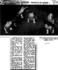
This article by journalist Bill Hitchings describes the state of the land market and cost of transporting building materials, Phillip Island, late 1960s. At that stage a number of outlying residential estates had been created, especially on Phillip Island South Coast and at Cowes West. While blocks of land on the outlier estates were very cheap and poorly serviced, the Cowes blocks were selling at $3000 per residential block. Hitchings quotes the owner of the Hollydene motel, Reg Orr, as saying that when the new bridge opens shortly he did not expect it to create a rush of visitors or residents.Bill Hitching was a well-known Melbourne journalist. This article gives an idea of land values on Phillip Island in the late 1960s, the fact that business owners were prepared to upgrade and expand their businesses to cater for extra potential demand on accommodation, and the strong identification of Phillip Island with the Phillip Island Penguin Parade in the minds of the general public in Melbourne. The significance of the new Phillip Island bridge to Phillip Islanders and visitors, and the cost of the bridge, are also outlined. Reg Orr was highly active in the business community of that era on Phillip Island. The Hollydene motel was a well-known Phillip Island accommodation venue.T-shaped article cutting with large image at top of article, dark due to poor photcopy. Double collumn text under photo clearly readable. Black and white.Sun/29/8/6 (?) Probably: Melbourne Sun newspaper, 29 August, 1969phillip island, phillip island tourism, development, hollydene motel, reg orr, phillip island penguin parade, land values, phillip island first bridge, phillip island 2nd bridge, transportation costs -
 Phillip Island Conservation Society Inc.
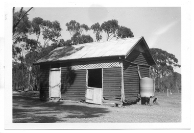
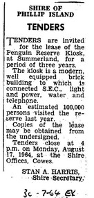
Work on paper - Photocopy of newspaper cutting, Wonthaggi or Powlett Express newspaper, "SHIRE OF/ PHILLIP ISLAND/ TENDERS", 30.7.1946
Shire of Phillip Island managed the Phillip Island Penguin Parade during this era, and made several improvements for visitors including the building of a kiosk for food and beverage and some souvenirs. The building was located on a bitumen area at the base of the hill along with a brick toilet block. The area was actually raised from creek bed adjacent to the bitumen area, with Little Penguin rookery either side. The Shire tendered out the contract for the running of this kiosk on a 3 yearly basis.This small public notice from a Wonthaggi newspaper at a time when no local newspaper was being published on Phillip Island, marks the time when the Shire of Phillip Island began to increase provision of tourist facilities at the Penguin Parade. The number of visitors being 100,000 for the previous year is also an excellent indication of the popularity of the Penguin Parade. The listing of infrastructure available to the building is useful.Photocopy of Public Notice, Rectangular. Single collumn with heading, sub-heading, 5 paragraphs of text and Name and position of Shire Secretary. Black and white."30-7-64 EX" Meaning: 30.07.1964. Powlett Express newspaper.phillip island penguin parade, shire of phillip island, penguin parade kiosk, tender process, penguin parade visitor numbers, sec state electricity commission, stan harris phillip island shire secretary -
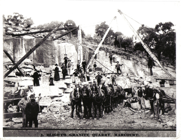 Harcourt Valley Heritage & Tourist Centre
black & white photograph, Granite Quarry, early 1900s
J Blight's quarry is located on Mt Alexander. It was opened up by Blight, a Cornish born quarryman turned gold-miner, in 1862. The quarries supplied Harcourt granite to monumental yards and building sites all over Australia. The photo depicts the average workforce of the Harcourt granite quarry as well as the methods of transportation of the heavy blocks of stone. B & W photograph showing 19 workers on the floor of the quarry using cranes to lift large blocks of granite onto lorries drawn by teams of horses. Several women and a child are watching -
 Wodonga & District Historical Society Inc
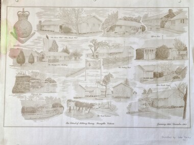
Work on paper - Sketch - The School of Military Survey, Bonegilla
Bonegilla operated as an army base from September 1940 and by 1943 was expanded to 848 buildings, including a general hospital. It provided training for small arms instructors, signallers, transport workers, bomb disposal and gas warfare personnel. In a response to the need to house the growing number of displaced persons coming to Australia, the Bonegilla Reception and Training Centre began operating in 1947. For some time it was a shared facility but the Army withdrew temporarily from Bonegilla in 1949, whilst still retaining ownership of the site. From 1949-65 Bonegilla Reception and Training Centre operated without a military presence. However, in the late 1960s and Australia’s commitments to the Vietnam War and pressed by the need to find accommodation to train men, especially National Servicemen, the Army negotiated with the Department of Immigration to take over several blocks at Bonegilla in 1965. Thirty-five huts were acquired by the Royal Australian Army Ordnance Corps as a Recruit Training Centre in which National Servicemen and recruits could attend 10-week ordnance courses. Shortly afterwards additional huts were acquired by the School of Military Survey, which established field-survey practical training areas and special astronomical observation sites as it began conducting courses in surveying. Instructors and trainees co-located at Bonegilla with migrant reception centre. In 1971 the Reception Centre closed and the site reverted to the Army. Progressively after 1971 the Army undertook a major site redevelopment with the construction of Latchford Barracks as the Army Apprentice School. Later Latchford Barracks was redeveloped into part of the Army Logistic Training Centre. Block 19 of the Mirant Reception Centre later became the Bonegilla Migrant Experience Heritage Park.This item depicts a heritage listed historical site located in the Wodonga district.A large poster size representation of the variety of buildings at Bonegilla, Victoria when it served as the location for the Royal Australian School of Military Survey. The insignia of the Royal Australian Survey Corps is featured in the top left hand corner.Top left corner: Insignia of the Royal Australian Survey Corps At bottom of sketches: "The School of Military Survey, Bonegilla Victoria / January 1966 - December 1982migrant reception centre bonegilla, army at bonegilla, australian military -
 Wodonga & District Historical Society Inc
Photograph - Codling Collection 01 - Wodonga's Second Police Station
Miss Olive Codling was a Foundation Member and a Life Member of the Wodonga Historical Society. Many of her prize-winning photos are held in the Society Collection. She also held a range of roles and committee positions in a wide range of Wodonga community organisations. WODONGA'S SECOND POLICE STATION - This building was located on the west side of High Street near the railway line at the corner of High Street and Bond Street. The building in the background was the Bond Store which was later repurposed to become the Court House. This Police Station, which began operation on this site c1905, had originally been the house of the customs officer. It had a front office and a Sergeant's and an Inspector's office as well as 2 barrack rooms and a laundry at the rear. In the backyard was a blue stone cell block and a night soil toilet, as well as a stable used previously for horse and carriage. Opposite the police station was a boarding house which supplied meals to prisoners. This police station was in use until its move to Elgin Street, Wodonga in December 1967.This photo collection is significant as it documents how the businesses and buildings in Wodonga have evolved and contributed to community throughout the 20th century.Two black and white photos of the 2nd Police Station built in Wodonga with the former Bond Store in the background.high st wodonga, police stations wodonga -
 Wodonga & District Historical Society Inc
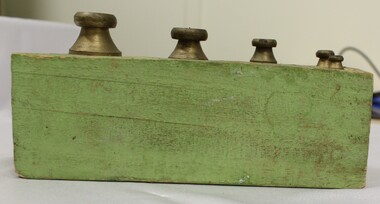
Functional object - Set of Weights in wooden holder, 1970s
The green holder for the weights was hand made by cutting recesses out of a single piece of wood. The wood was painted green. Between 1960 and 1988 Australia gradually adopted the SI units (Standard International) or metric units. In 1970 the Australian parliament passed the metric conversion act, and the Australian building trades made it the standard in 1974. This information helps to date the set of weights to C. 1970s.These weights have local and social significance to indicate the weights used in many homes or small businesses in the 1970s.Set of 5 small metric weights in wooden holder. Measurements are difficult to decipher but "Gram" can be identified around the edge of some weights. Holder has been created by cutting round recesses into a block of wood.metric system, weights and measures australia -
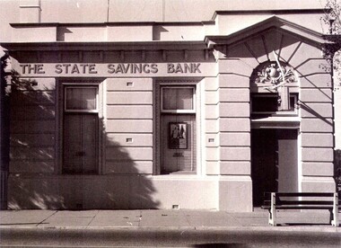 Wodonga & District Historical Society Inc
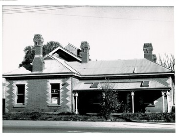
Photograph - State Bank of Victoria, Wodonga
The Title for the land on which this building stands was granted on 27 August 1857 and the land was bought by Keith Field and A. Maitland. It stood on 1 / 2 acre of land with 250 lengths down South Street and 200 lengths along Sydney Road. The 1 / 2 acre block on the northern side was also purchased by the same buyers. The State Savings Bank was built in 1915, just three years after the State Savings Bank of Victoria was established. It was branch number 731. The building served as a bank until about 1970. It is now owned and used as an office by a local law firm. It is a single storey rendered masonry building with a parapet concealing the roof. Key features of the High Street facade are horizontal bands of masonry, timber windows outlined with moulded details and ornamentation accentuated the door. A more modern branch was opened in a more central location in HIghs Street. The State Bank of Victoria was taken over by the Commonwealth Bank in 1990. These images record the premises of a bank which served the Wodonga community and businesses for many years.3 photos of the State Bank of Victoria in High Street Wodonga at various points in its history.state bank, wodonga businesses, financial institutions wodonga -
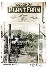 Wodonga & District Historical Society Inc
Photograph - Wodonga Plant Farm
Stan and Mary Parker commenced the Plant Farm in Smythe Street Wodonga in February 1949. The nursery consisted of two blocks, on one of which their house was built. They started off with approximately £70 and a 1939 Singer mini-Ute. In the early days most customers came from the farming community. In late 1951 the Parkers purchased to a new site on the corner of High and Osburne Streets. Business went well and in 1957 they purchased the adjoining block. They later demolished the old house on the corner of High Street and Osburne Street, building a new home lower on the same block. As the nursery prospered Stan and Mary built a shop and showrooms with glassed-in portion for the indoor plants and a large shaded area for the display of shrubs. In 1978 they sold the nursery to Mr. & Mrs. John Gale. In 1981 the Wodonga Plant farm was purchased Geoff and Kay Pollard and they moved to its current location at the corner of Beechworth Road and Huon Creek Road. Initially they brought it as an investment but it soon got into their blood and chose to not only continue but expand the nursery and its offerings. This included a large showroom, a water shop which specialises in pool equipment, chemicals and water testing, a children's playground and an outdoor blind centre. Further expansions led to the addition of a Tuscan-style cafe on the site which has become a meeting place. The business was nominated the Yates Victorian Best Garden Centre in Australia for many years and won the award in 1997. In 2024, the Wodonga Plant Farm is still a vibrant and popular business being operated by the Pollard Family.These items are significant because they document the story of respected Wodonga Business which has served the community for over 60 years.A selection of photographs and article documenting the story of the Wodonga Plant Farmearly wodonga businesses, wodonga plant farm, pollard family, geoff and kay pollard -
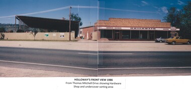 Wodonga & District Historical Society Inc
Photograph - Holloways Building Supplies
Eric Holloway began spot milling timber at age of 17. He borrowed fifty pound from an uncle in 1934 to purchase a McCormick Deering tractor and saw bench. He went from farm to farm cutting timber for farmers. For a time, he worked on Shelley Station spot milling with WS Walker and Son. In approximately 1946 Arthur and Eric Holloway established a saw mill at Shelley. Another brother Ernie, a builder and returned soldier, worked with them from time to time. Using timber sawn in the mill he built eight basic houses for the mill workers. The brothers employed many migrants: - Yugoslav, Czechs, Russians, Ukrainians, Serbs as well as other hardworking people. This meant there were families, so Ernie also built and furnished a school at Shelley. Application was made for a teacher from the Education Department. At the Shelley mill the workers used ex-army blitzes, GM trucks (for carting logs) army ducks and a centurion tank for parts. The timber from the mill was trucked to Albury and Wodonga, customers being FA Stowe and Mates Timber. The army was also a big customer with Holloways supplying timber for the army huts that were built at Bandiana. A timber mill that had been built at Tallangatta by State Rivers and Water for the purpose of establishing New Tallangatta, was purchased by Holloway Brothers as an extension of their Shelley operation. In 1954 a new mill was built at Granite Flat on the Omeo Highway and the Shelley operation closed. Ernie Holloway was involved in the building of the mill and accommodation houses in Mitta Mitta. The mill workers travelled from Mitta to work each day. Holloways Building Supplies was established at 49 Tallangatta Rd Wodonga at this time. It was established on four house blocks with a little shed, with more land being acquired as the operation expanded. The brothers realized that it would be more profitable to set up their own timber outlet to supply their customers. Arthur Holloway continued to run the sawmills while Eric Holloway concentrated on the Wodonga business. A hardware store, offices and joinery were built as demand continued for building materials. All the timber arriving in the yard from the mill was hand sorted, providing employment for many. With the milling and timber outlets Holloways provided employment for approximately forty staff. The next generation of the Holloway family became involved. A Hyster forklift was purchased which allowed for bulk handling of the timber. Land was purchased in Sanyo Drive where timber was cleated and dried. Select grade timber, F17 dry framing, builders hardware and tools were sold. Holloways endeavoured to be a one stop shop for framing and fitting out of houses. In 1989 the business was sold to Mt Beauty Timbers who later on sold to Dahlsens. The timber mill was decommissioned. The Holloway family retained the ownership of the premises of 49 Thomas Mitchell Drive leasing to Dahlsens until that operation was moved to Albury in 2013. In 2014 the lease land was sold to two local businesses. Leigh Martin Marine purchased the parcel of land adjoining their business. Lester and Son purchased the remaining block and demolished the premises. A funeral parlour was built on that site.These photos are significant because they document the story of an important Wodonga business.A series of coloured photographs depicting aspects of Holloways Building Supplies business in Wodonga.holloways wodonga, wodonga businesses, timber industry -
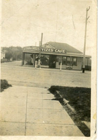 Lakes Entrance Historical Society
Photograph - Vizes Cafe, 1939c
Name changes with change of ownership, finally Bamboo Cafe, rebuilt as Bamboo Motel 1960c by Con Coucoulos.Black and white snapshot of Vize's Cafe, showing sign for Fish Grills, over veranda, large Bushell's Tea sign on wall. Building appears to be remodelled weatherboard residence, set on a corner block, facing Esplanade. A billiard room was situated behind the cafe. Lakes Entrance Victoriarestaurant, room display -
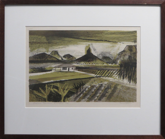 Federation University Art Collection
Work on paper - Artwork - Printmaking, Jack, Kenneth, "Glasshouse Mountains, Queensland" by Kenneth Jack, 1961
Kenneth JACK AM MBE RWS, (5 October 1924 – 10 June 2006) Australian watercolour artist Kenneth Jack who specialised in painting the images of an almost forgotten outback life; old mine workings, abandoned ghost towns, decaying farm buildings. He became a professional painter at the age of 39 after giving up his job as senior instructor at the Caulfield Institute of Technology. In 1977 he was elected to The Royal Watercolour Society and in 1982 was awarded the MBE, and the Order of Australia (AM) followed in 1987. Framed three block linocut depicting the Glasshouse Mountains in the Australian State Queensland. Donated through the Australian Gifts Programme by Katherine Littlewood.21/32artwork, artist, kenneth jack, printmaking, glasshouse mountains, queensland, available, linocut -
Port Melbourne Historical & Preservation Society
Plan - Handcoloured identification of wood and brick buildings, hotels and lanes on copy of a section of MMBW map, 1930s
Given to Peter LIBBIS, who hand ocloured legend etc. while researching his house and family, then donated to society in 1997.Photocopy of MMBW plan 326 - block between Stokes and Princes, Rouse and Graham. Colour coded for brick or wood builidngs, lanes marked in green and four hotels indicated.As abovereligion - roman catholic church (st josephs), peter libbis, business and traders - hotels, built environment -
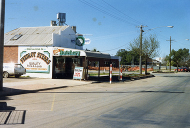 Charlton Golden Grains Museum Inc
Photograph, Charlton Shire, Turner's Butcher Shop, Hight St Charlton, c.1987
Part of a Shire streetscape series of photos c. 1987Colour photograph of Turner's Butcher Shop on the corner of Learmonth and High Streets. Sign above the verandah reads Turners Butchery and has a picture of a ram's head between the two words. The signage on side of building reads Specialising in FEEDLOT STEAKS, QUALITY Pork & Lamb, Friendly Service. Deliveries. The sign on the side of the bullnose verandah reads TURNERS Butchery Phone 911506. A sandwich board in front of the shop on the edge of the footpath reads Butcher NOW OPEN. A white station wagon is parked in the yard beside the shop. There are two red and white school crossing posts on the rod in front of the shop. A building is under construction in the block across the road and there is orange safety fencing around the front of the block. The mill silos are visible behind the butcher shop.turner's butcher shop, high st charlton, learmonth st charlton, business -
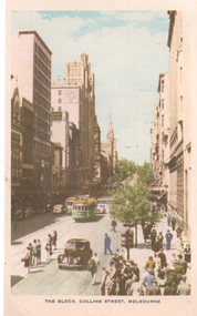 Melbourne Tram Museum
Postcard, Nucolorvue Publishing, "The Block Collins Street Melbourne", 1930s
Niucolorvue postcard titled "The Block Collins Street Melbourne", looking east from Elizabeth St. Has two W2 class trams in the view. As well as Kodak House, Howey Court, Manchester Unity building, and the Town Hall are in the background.Yields information about Collins St, during the 1930s.Postcard - printed, unused, coloured, by Nucolorvue Productions, Mentone Victoria.trams, tramways, w2 class, collins st -
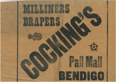 Bendigo Historical Society Inc.
Ephemera - Three samples of wrapping paper
Robert Samuel Valentine Cocking (1882 - 14/5/1945) Born in Bendigo, Val Cocking began hi retail career at Myer Bendigo before opening his own draper shop c. 1912 in the lower block Pall Mall. In 1914 he moved his stock into temporary premises while he renovated his new shop, which combined the former Post Office Hotel and adjacent grocery and stationary shops. The new emporium opened in Aug 1918 selling drapery and soft goods. Mr Cocking was a champion rifle shooter; President of the Bendigo Chamber of Commerce; President of the Sandhurst Football Club for 18 years and President of the Bendigo Cricket Club. Bennetts Hardware shop was in Hargeaves St near the entrance to Allan's Walk in the 1950's. Beehive buildings. This was originally the Sandhust Mining Exchange and as such was the oldest purpose built exchange in Australia and was one of only two in regional Australia. It was initially established in the 1850's to service the miners of the area. It's first double story incarnation as the Bendigo Stock Exchange, contained up to 2000 stockbrokers and 5000 shareholders. In 1871 the building burnt to the ground and the new and current building was completed in 1872. The modern building was designed by Charles Webb, who was also responsible for the Royal Arcade in Melbourne. and features a pitched glass roof similar to the Royal Arcade, Melbourne.Three samples of wrapping paper from a. Cockings, b. Bennetts Store & c. Beehive storeswrapping paper, cockings, bennetts, beehive -
 Port Melbourne Historical & Preservation Society
Photograph - Former Freemason's Lodge Building, Stokes Street, Sandridge/Port Melbourne, 2000 - 2009
The Sandridge Marine Lodge was founded in 1858. Two locations; originally Stokes St and then in Liardet St from 1917. Both buildings are now converted to apartments. .02 - 1st Lodge building in 2000s as an apartment blockbuilt environment - civic, built environment - domestic, societies clubs unions and other organisations, built environment - industrial, freemasons lodge, swallow & ariell ltd, sandridge marine lodge -
 Port Melbourne Historical & Preservation Society
Photograph - Former Freemason's Lodge Building, Liardet Street, Port Melbourne, 1917
The Sandridge Marine Lodge was founded in 1858. Two locations; originally Stokes St and then in Liardet St from 1917. Both buildings are now converted to apartments. .05 - Photo of 2nd Marine Lodge (Freemasons) converted to apartment block in early 2000sbuilt environment - civic, built environment - domestic, societies clubs unions and other organisations, built environment - industrial, freemasons lodge, swallow & ariell ltd, sandridge marine lodge -
 Bendigo Historical Society Inc.
Photograph - T C WATTS & SON COLLECTION: 20 BANCROFT STREET, 1930
BHS CollectionBlack and white photograph mounted on rectangular grey board. House, brick, corrugated iron roof, bullnose verandah, shutters on end window, creeper on verandah posts, 'fan' in fill to gable, scalloped picket fence, telephone pole outside corner of block. 20 Bancroft Street.Frank A. Jeffree, Bendigoplace, building, residential, stamped on back in rectangle ''t.c. watts and son/auctioneer/estate agents/253 mitchell street/bendigo'' stamped on back in circle ''royal historical society of victoria, bendigo branch'' -
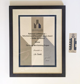 Working Heritage Crown Land Collection
Award - Mint Award, Master Builder's Award for the Mint
Framed award with text and an angular block colour design Master Builders Australia Inc National Commercial-Refurbishment/Fit-out/Alterations Award- Under $5 Million Winner The Royal Mint Building Project Awarded to J.A.Doddawards, historic building, former royal mint -
 Bendigo Historical Society Inc.
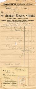
Document - ALBERT BUSH'S STORES INVOICE
Born in England in 1832, Albert Bush was attracted to Australia by the lectures of Dr Laing. In 1852 he travelled to Queensland and later to Sydney before coming to Bendigo. His initial mining efforts were not successful so he gained employment as a clerk in a grocery store. In 1857 he opened his own grocery shop in partnership with Mr Ferris. He bought out Ferris in 1859. In 1859 he married Jane Dalton (1836-1919). Following his death the business was continued by his son.Albert Bush's Stores Invoice. Cream paper with black print, hole in the centre. Bush's Moulamein & Wakool. Dated at Bendigo August 5th 1929. Mr S. A. Bush. Both of Albert Bush's Stores General Providers. Grocers, Bakers and Pastry cooks, Drapery, Hardware Timber, Woolpacks and Cornsacks. Insurances, Mitchell Farm Machinery, Mt Lyell Manures Sheep Dips, Building (under our own supervision). Invoice for 1 truck Box Blocks. Freight seven tons. Cartage Buckell & Jeffrey. Truck 1515. Receipt attached no. 172 dated August 19th 1929 with orange Stamp Duty Stamp for 2d. Mr S.A. Bush By Cash Cheque £11:6:1 Albert Bush's Stores. Box 625business, retail, general, albert bush's stores. s.a. bush -
 Linton and District Historical Society Inc
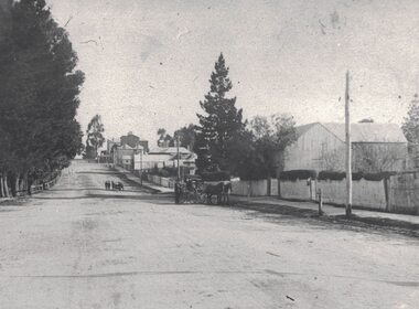
Photograph, View along Sussex Street, Linton, circa 1920
Dr Donaldson (Snr) owned the block of land on the corner of Sussex and Grant Streets, Linton. He had a ten-room house set on the back of the block (where the block backs on to Surrey Street), with a large barn fronting Sussex Street. Other identifiable buildings in the photograph are Ball Brothers blacksmith's shop, the Royal Standard Hotel on the corner of Sussex and Clyde Streets, the Shire Hall, Criterion House and Joseph Shepherd's store. The roof of Oscar Ball's house can be seen.Black and white copy of original photograph which shows houses and other buildings along Sussex Street. The view is to the south (up the hill) from the Ballarat entrance to Linton. A large barn, enclosed by a picket fence, is in the foreground. A cart drawn by two horses, with a man standing next to it, is in the street near the barn. Further along the street, a group of people appear to be wheeling a barrow or cart. Houses and other buildings can be seen along the street.sussex street linton, dr donaldson's barn, ball bros. blacksmith, royal standard hotel, shire of grenville offices linton, criterion house, joseph shepherd's store -
 Wodonga & District Historical Society Inc
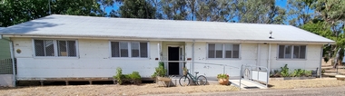
Photograph - Hut 97 Bonegilla Migrant Experience
Bonegilla Army Base and Migrant Reception Centre began when funds were allocated to build Bonegilla Army Camp in June 1940. Builders began to erect about 600 huts prior to the Army moving in during September of that year. Between 1942 - 1943 it was enlarged to 848 buildings. In 1947 Bonegilla Reception and Training Centre began operating with the Army providing transport, security and catering services. From 1949 until 1965 the Bonegilla Reception and Training Centre operated without a military presence. Bonegilla Migrant Reception and Training Centre was made up of 24 blocks. It had its own churches, banks, sporting fields, cinema, hospital, police station and railway platform. It became the largest and longest operating reception centre in the post-war era. More than 300,000 migrants passed through its doors between 1947 and 1971, with most of those originating from non-English speaking European countries. From1965 with the increased Australian commitment to the Vietnam War and the need to find accommodation to train National Servicemen for Vietnam, the Army negotiated with the Department of Immigration to take over several blocks at Bonegilla. In 1971 the Reception Centre closed and the site reverted to the Army. After 1971 the Army undertook a major site redevelopment with the construction of Latchford Barracks as the Army Apprentice School. Later Latchford Barracks was redeveloped into part of the Army Logistic Training Centre. Between 1978 and 1982, nearly all of the centre was demolished in a major redevelopment. The new replacement buildings were formally opened as Latchford Barracks in 1983. Demolition of the buildings prompted calls for recognition of the site and the role it had played in Australia’s post-World War II Immigration program. After much discussion between the Department of Army and Heritage and local groups about the significance of the site, the Australian Heritage Commission proceeded with its listing on the Register of the National Estate. A Conservation Management Plan was prepared for Block 19 in 1996. The Army transferred Block 19 to the Victorian Government. In 2002 Heritage Victoria listed Block 19 on the State Heritage Register, giving attention to both the migrant and army connections with the site. Hut 97 at Bonegilla Migrant Experience is the home of the Wodonga & District Historical Society Inc.This image is significant because it records a building which is part of the Bonegilla Migrant Reception Centre which played a critical role as the largest and longest operating Migrant Reception Centre in Australia.A colour photo of Hut 97 at Block 19, Bonegilla Migrant Experience, now the home of Wodonga & District Historical Society Inc.hut 97 bonegilla migrant experience, wodonga & district historical society, immigration australia