Showing 11183 items matching " planning"
-
 Vision Australia
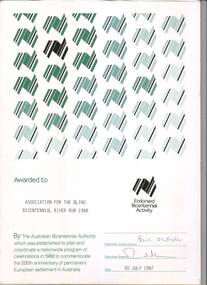
Certificate - Text, Association for the Blind: Bicentennial River Run 1988, 1987
Certificate reads "Awarded to Association for the Blind Bicentennial River Run 1988. By the Australian Bicentennial Authority which was established to plan and coordinate a nationwide program of celebrations in 1988 to commemorate the 200th anniversary of permanent European settlement in Australia" Signed by the Chairman: Victoria Council (illegible) and Executive Director (illegible), dated 30th July 1987. All text on this certificate is located on the bottom half of the document. The top half is populated by a repeated stylised graphic of a map of Australia, in various shades of green and gold. There is also a gold version of the same logo, labelled with "Endorsed Bicentennial Activity" , situated above the official signatures. 1 certificate with Australia imageryassociation for the blind, awards -
 Melbourne Tram Museum
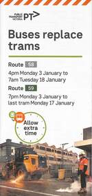
Pamphlet, Yarra Trams, Buses Replace Trams - Routes 58, 59, 86 and 96, 2022
.1 - pamphlet provided at tram stops giving details of the works and bus services for routes 58 and 59 .2 - Project document describing the work and dates - downloaded from the Yarra Trams website after buses were used to replace route 58 from the Royal Children's Hospital rather than from Royal Park Station as originally planned. .3 - as for .1 - for the upgrading of the Merri Creek Bridge - route 86 - see also Reg Item 6066 .4 - as for .1 - for the installation of superstops in Nicholson St between Elgin St and Holden St - route 96Shows the methods that Yarra Trams customers are advised of changes due to track replacement works..1 - Pamphlet - DL, four fold printed on off white paper titled - Buses Replace Trams - Route 58 and Route 59 - Jan 2022 .2 - Project sheet - 3 A4 sheets, titled "Renewal works: Essendon Depot and Mt Alexander Road - 3.1 to 18.1.2022. .3 - Pamphlet - DL 3 fold, Buses Replace Trams, route 86, November 2021 - Merrit Creek Bridge works .4 - Pamphlet - DL - 4 fold, Buses Replace Trams, route 96, January 2020 - Nicholson St works for tram super stops.mt alexander road, tram works, track work, route 58, route 59, yarra trams, ptv, essendon tram depot, route 86, route 96, nicholson st, merri creek, bridges, carlton, super stops, trams, tramways, northcote -
 Forests Commission Retired Personnel Association (FCRPA)
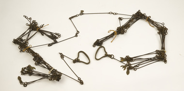
Gunter's Chain
Before metrication was introduced into Australia in the 1970s land was measured in chains and links. Many old parish plans show length measurements in chains and links. Area was shown in acres, roods and perches. Gunter's chain was used for measuring distance in surveying. It was designed and introduced in 1620 by English clergyman and mathematician Edmund Gunter (1581–1626). Gunter developed the measuring chain of 100 links. The chain and the link, became statutory measures in England and subsequently the British Empire. After metrication units of length were measured in meters and area in hectares. The chain was later superseded by steel ribbon tape.The 66 foot long brass Gunter's Chain is divided into 100 links (each 7.92 inches long), and marked off into groups of 10 by shaped tags which simplify intermediate measurement. It was heavy but flexible enough to be dragged through the bush on surveying transects.(Hence the common forestry term "chainman). The chain was a precision part of a surveyor's equipment. It required frequent calibration, yet needed to be sturdy enough to be dragged through rough terrain for years. It has brass hand grips at each end of chain. 1 chain = 100 links = 22 yards = 66 feet = 792 inches. 10 chains = furlong 80 chains = 1 mile 1 acre = 10 square chains = 4 roods (1/4 acre) = 40 perches.forest measurement, surveying, forests commission victoria (fcv) -
 Melbourne Tram Museum
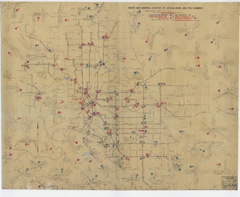
Drawing, Melbourne & Metropolitan Tramways Board (MMTB), "Route Map showing location of special work and pole numbers" "substations", late 1942
Map of the system shown at two inches = 1 mile. Drawing No. P5799. Shows crossovers, track layouts at junctions, signal cabins roads, railways, and stations. Originally signed by Perway Engineer - 20/12/1940, though originally drawn in 1922. The plan shows the lines to Maribyrnong Munitions works along Cordite Ave and Wests Road and the track from Moonee Ponds to Union Road, opened in July 1941, and the extension to Essendon Airport built in 1942, but not the Queen St North Essendon substation. Shows underground cables, tram and bus depot, workshop locations, and substation locations and their priority.Yields information about the MMTB substation locations in 1942.Drawing - dyeline cloth backed print - titled - "Route Map showing location of special work and pole numbers" and subtitled - "Substations". trams, tramways, mmtb, trackwork, tramways, junction, map, world war 2, substation -
 Mission to Seafarers Victoria
Letter - Correspondence, 1/12/1950
Allan writes of being in Gothenburg the day after the Swedish King died (November 1950).Quinn CollectionA three-page letter written in green ink on three pages of buff coloured unlined paper (0851.a1-3) headed M.S.Mongabarra, Norrkoping, Sweden and dated 1/12/50. The pale blue envelope (0851.b) is addressed to Mrs K Hayes, 14 Fitzroy Street, St Kilda, Victoria. There are 9 red stamps, valued at 20 Norwegian Krona each, and one green stamp, valued at 10 N.Krona, across the top of the envelope. There are three postmarks.In this letter to his mother Allan describes how beautiful it was sailing into Norrkoping with everything covered with just a little snow but after a snow-storm the next day the ropes were frozen and the tarpaulins were like sheets of iron. The ship is half full of timber for Australia and will arrive in Adelaide in late January 1951 but he won't be on it as he is handing in his book and will sign off in Gothenburg on the 11th December. He plans to spend Christmas in Oslo before travelling to London. He anticipates being back in Australia for good in the middle of 1951. letters-from-abroad, allan quinn, m s mongabarra, antwerp, gothenburg, norrkoping, sweden -
 Seaworks Maritime Museum
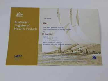
Certificate, Australian Register of Historic Vessels Certificate - Idler, 2012
Certificate or registration of the Historic Vessel the 'Idler' which is currently also at the Seaworks Maritime Discovery Centre.This certificate registers the 'Idler' as a surviving vessel of relevance to Australia's maritime heritage.Certificate from the Australian Register of Historic Vessels from the Australian National Maritime Museum. For the vessel, the Idler. Signed on 25th May 2012"Australian/ Register/ of/ Historic Vessels/ Australian National Maritime Museum." "The vessel/ Idler/ has been accepted into the Australian Register of Historic Vessels/ on/ 25 May 2012/ signed/ Kevin Sumption Director/ Australian National Maritime Museum." "The Register records surviving vessels of relevance to Australia's maritime heritage. It is/ building a national picture of boats and their designers, builders and owners from around/ Austrlia, to promote understanding of their connections with their communities past and /present, and to encourage awareness and planning for their preservation and use./ The ARHV is managed by the Australian National Maritime Museum in association with /Sydney Heritage Fleet." -
 Eltham District Historical Society Inc
Photograph, N. J. Tillings Timber Factory, 15 June, 1975, 15/06/1975
N. J. Tillings Timber Factory was part of the Brougham Street, Light industrial area, Eltham. Brick bulidings includes signage: Wakefield Pr... (printer?) No 17 Building C. This is one of 7 B/W 8x10 inch photos with notes on obverse by Dick Crichton. Accompanying letter from Florence Chrichton 2013 : "Originally sent to Shire of Eltham Engineer, Mr. McDonald. [These photographs were part of their campaign to the Shire of Eltham in 1975] claiming that the zoning regulations were being breached by the occupants of various factories in the nearby light industrial zone [Brougham Street, Eltham] - to the detriment of those living in adjoining residential zones, and that, despite .. earlier objections and complaints, nothing was done about it."1 black and white photograph printed with white borderInscribed on back: "Weekend photograph of factories in Brougham Street surrounded by by residential zone. On weekdays cars surround premises - these have been built approx. two years - where is the landscaping? * Undeveloped light industrial land. Careful planning needed for future. Being on high elevations backs of future buildings will be seen from Main Road Eltham and future Art Centre complex. Also Bolton Street becoming heavily used arterial road. Off street parking facilities most important." . The front of the photo has pen marks indicating points of interest.industrial estate, brougham street, eltham -
 Flagstaff Hill Maritime Museum and Village
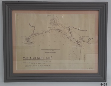
Document - Location Chart, The Mahogany Ship, 2007
This chart shows a possible site for the fabled wreck called the 'Mahogany Ship'. Flagstaff Hill’s collection includes other objects that some say could be relics from this Ancient Wreck, (also called the Gold Ship, or the Ancient Vessel). The chart shows the coordinates for the Summits of Griffith Island and of Middle Island. It also has the depths of the sea at various intervals and shows the shore and sand dunes, lighthouses and other reference points. The mystery of the Mahogany Ship began in 1836 when two shipwrecked sealers discovered the remains of an “ancient vessel” in the sand dunes about four miles west of Warrnambool. Since the last recorded sightings in the 1880’s the true origin of the Mahogany Ship has remained one of Australia’s most famous historical mysteries or fables. One of the more recent theories is that the vessel was one of the Portuguese ships exploring the Australian coast in 1522. For over one hundred years searchers have attempted to locate and identify the wreck. The search continues for the tangible evidence which will once and for all establish the Mahogany Ship’s place in Australia’s History.The chart represents the worldwide interest in locating the wreck of the Mahogany Ship. Locating the actual wreck or proving the existence of a Portuguese ship's wreck could change the history of the discovery of Australia. A Mahogany Ship committee was formed to gather and research information about the discovery of the wrecked ship. A large amount of money was offered as a prize for finding the wreck or parts of it. People have written books, painted images, made videos and told tales of the ship but it continues to remain a mystery or even a fable. The chart is significant for its possible link to one of Victoria’s and Australia’s maritime mysteries, the Mahogany Ship (also known as the Ancient Wreck). It is one of very few known relics that could give evidence of the existence and history of the vessel. It is listed on the Victorian Heritage Register S438 as it is one of Victoria’s oldest recorded shipwrecks. The identity of the vessel has the potential to change Australia’s history.A chart in a wooden frame, behind glass. The chart shows the approximate position of the mystery Ancient Wreck, later called the "Mahogany Ship". The chart is a copy and is based on the Admiralty Chart by Lieut. Stanley, dated 1872. Lower left: "THE MAHOGANY SHIP" "LOCALITY PLAN, ENLARGED FROM LIEUT. STANLEY'S ADMIRALTY CHART 1872" "APPROXIMATE POSITION OF WRECK MARKED [symbol of a Portuguese cross]" Other labels on chart: "BELFAST" "PORT FIARY" "GRIFFITHS I" "RIVER MOYNE" "RIVER MERRI" "ARMSTRONG BAY" " GORMANS LANE" "TOWER HILL" "KOROIT" "HELEN ROCK" "WARRNAMBOOL" "LADY BAY" "MIDDLE I" "LIGHT HO." Lower right: "G 410 B" Label on the back; "This chart presented to the Mahogany Ship Committee and Flagstaff Hill by Avis Quarrell, April 2007"warrnambool, shipwrecked coast, flagstaff hill maritime museum, shipwreck coast, mahogany ship, ancient vessel, ancient wreck, portuguese ship, coastal reserve, fabled wreck, gold ship, griffiths island, belfast (now port fairy), koroit, location plan, leuit. stanley, admiralty chart 1872, tower hill, merri river, moyne river, middle island, helen rock, armstrong bay, griffiths land -
 Federation University Historical Collection
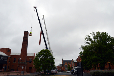
Photograph - Colour, Phil Bryce, Removal of a fibre-glass chimney extension from a chimney from the former Ballarat Brewery, 2015, 13/11/2015
The chimney extension on what was the former Carlton and United Breweries boiler house at Ballarat installed in 1972 and it is constructed of a special formulation of fibreglass reinforced plastics designed to operate at elevated temperature (ie boiler flue gas). It is thought to be one of 26 or 28 fibreglass boiler chimneys designed and installed in Victoria in the 1970s, and is thought to be one of the last to be removed. In its day the fibreglass chimney extension was at the cutting edge of fibreglass technology and is therefore well worth retaining. Removal of the chimney extension to the brick chimney outside the brewery building was deemed necessary to prolong the life of the chimney, and also because the fibreglass extension had reached end of life and posing a possible threat. According an Engineering assessment, fibreglass structures have a life expectancy of between 20 years (when fatigue loaded) and up to 100 years (static loaded). We don’t know when it was added to the chimney but believe it was most likely in the early 1970s. Given that it is subject to wind load and often observed to be moving in the wind it is likely that it will be at the end of its life. The chimney will be made good and we have the necessary planning approvals in place to undertake the works. The chimney extension was removed on 13 November 2015 in accordance with a planning permit obtained by the University. The extension is believed to have been added in the 1970s and was predominantly made from fibre glass. The structure was removed for safety reasons and to preserve the integrity of the historic brick chimney which supported it. Coloured digital photographs associated with the removal of a fibreglass extension to a chimney which was part of the Former Ballarat Brewery/Carlton and United Breweries complex. Images also include the last day the chimney was in situ.chimney, fibreglass, former ballarat brewery, former carlton and united breweries, ballarat school of mines, brewery complex -
 National Wool Museum
Sculpture - Bollard, Jan Mitchell, The Lost Bollards, 1999
Geelong is famous for its bollards. Created by local artist Jan Mitchell, the colourful bollards spot the foreshore, representing a fascinating and fun chronicle of the city’s past. Few people know that Mitchell planned for a flock of sheep to be part of her public art project. The wool industry is an important part of Geelong’s history, so Mitchell thought what better than a flock of sheep to welcome people to the city. The flock (and a Shepard) were to be placed out on the Melbourne-Geelong highway, near Lara, to welcome travellers to the city. The sheep would then be scattered along the road as a wayfinding signal to bring people to Geelong. When traffic authorities heard the plan for bollard sheep along the road, they squashed the project as a potential distraction for drivers. Another flock was also suggested for the hills of the eastern gardens, overlooking the bay. This was also disapproved; so Mitchell only ever partially completed four sheep bollards. The bollards are remnants of Jan Mitchell’s flock of sheep. The sheep also show the evolution of one of Geelong’s most iconic art installations. From the first sheep showing the raw timber of the old Yarra Street pier, to the sheep without a face, through to the completed sheep, it is possible to trace Mitchell’s process in the preparation of the bollards. The lost bollards form part of the National Wool Museum’s unique collection. The first bollard is the least complete, still in its original timber colour. From the central cylindrical shape, an additional wedge protrudes. This unpainted wedge forms what would have been the face of the sheep, with an ear present on either side that would have been painted white. Presently they are a bare metal. No legs are present on this bollard. The second and third bollard are completed to a similar level. They have a central cylindrical shape with an additional wedge protruding from the front of the timber. This wedge forms what would have been the face of the sheep, with an ear present on either side. The face and ears have been painted white but the finer details such as the eyes have not been added. These bollards bodies have also been painted white and have their legs attached. The legs are thin metal cylinders, approximately 50mm in diameter and 500mm long. The fourth bollard Is complete. It has the same central cylindrical shape with an additional wedge protruding from the front of the timber. This wedge forms the completed face of the sheep, with an ear present on either side that has been painted white. The face also features completed painted eyes. This bollard has its legs attached. The legs are thin metal cylinders, approximately 50mm in diameter and 500mm long. geelong, bollards, geelong's bollards, jan mitchell -
 Melbourne Tram Museum
Drawing - Tramcar floor plans to 1923, Melbourne & Metropolitan Tramways Board (MMTB), c1924
Set of 16 floor plans of electric trams of the MMTB and the trusts from the A class of 1910 to W class of 1923. Shows floor plan, seats and a table with car numbers, loading, truck type, type of equipment, horse power, remarks and total weight. 1 - Malvern Combination - A, B, H, J classes 2 - Drop centre cars - Malvern - C, E and D classes 3 - Summer car - Malvern - F class 4 - Short saloon combination - Malvern G class 5 - Short saloon combination - Malvern K class 6 - Four motor bogie car - Malvern - L class 7 - Combination car - Hawthorn - M class 8 - Drop centre bogie car - Hawthorn - N and P class 9 - Closed bogie car - Hawthorn - O class 10 - Combination car, Preston - R and Q class 11 - Combination car, Coburg - S class 12 - Double saloon combination car - Coburg - T class 13 - Box Car Essendon U class 14 - Cross seat (toastrack) car, Essendon, V class 15 - Four motor bogie car - W class 16 - "Birney" Safety car - X class Plain copies - black on white paper held for all cars except the X class.Yields information about various classes of electric trams up to about 1923 that the MMTB absorbed from the Trusts and/or built themselves.Folder of 16 blue prints secured with three brass clips,tramways, tramcars, floor plans, drawings, a class, b class, c class, d class, e class, f class, g class, h class, k class, l class, m class, n class, o class, p class, q class, r class, s class, t class, u class, v class, x class, pmtt, htt, mbctt, fnptt -
 Orbost & District Historical Society
documents, Original - 5.8.1912 - 8.7.1914
These photocopied documents were used in the Orbost Secondary College Library. In the latter half of 1913 working bees, concerts, balls, sports carnivals and collections were held to raise funds before The Hospital Movement felt they were ready to ask The Public Health Department for plans for a suitable building (2000 -2500 pounds) for use as a permanent hospital in Orbost. A Hospital Committee was formed and despite several a major setback (the president died in November 2013), continued to hold many public events in order to raise the funds necessary. Orbost Hospital was officially opened in 1930. ( Read Margaret Holland's "Orbost Hospital: History, Personalities and Stories.) These documents are a useful research tool on the history of Orbost Regional Health.A stapled collection of photo-copied minutes from the fund-raising committee for the Orbost Hospital.orbost-hospital health-fund-raising -
 Eltham District Historical Society Inc
Document - Property Binder, 810 Main Road, Eltham
Photocopy publication: Eltham Methodist Church One Hundred and Twenty-Five Years 1850-1975, Chris Allan editor. History of early Eltham, railway, schools, churches by A Bird. Map of Eltham with sites of significant buildings. Maps church site. Plan of church. Reminiscences by Edna Bill, Val Gangell, Don Brown. Notes by Ken Eckersall, Peter Gray, Ron Hubery. Newspaper article: Lessons in history, Diamond Valley News, 2 August 2000. Newspaper article: Parents stop teachers, Diamond Valley News, 2 August 2000, State-wide preschool teachers strike and Hurstbridge pre-school.main road, eltham, eltham methodist church, eltham uniting church, josiah holloway, hurstbridge pre-school, kinglake national park, churches -
Glen Eira Historical Society
Map - Cantala
Six pages of handwritten notes, undated and unattributed, detailing the history of the subdivision and demolition of Cantala, Dandenong Road, 40, Caulfield. The notes, which include a list of references, detail the main auction on 21/05/1938 and prices paid for the allotments. Also included in the file are photocopies of three auction posters for the 21/05/1938 auction in 32 allotments. Two of the posters are small and one of these includes a map (107mm x 110mm) of the Cantala Estate. The other poster is spread across three A4 pages and includes a map and plan (204mm x 110mm) of the allotments. There is an extra copy of the final page of this larger poster.miller septimus, miller helen m, mcintyre angus, miller n a, crouch h c, cantala, dandenong road, wiora, alma road, waiora road, findon avenue, cantala avenue, caulfield, caulfield north, st kilda east, yeo grosthwaite and co, abercromby and beatty pty ltd, mansions, land subdivision, house auctions, auctioneers, land sales, land values, architectural features, gardens, advertisements, racehorses, road construction and maintenance, surveyors, lawyers, minute books, trams -
 Eltham District Historical Society Inc
Journal, Peter Doughtery, ArtStreams: Arts & Culture in Banyule, Darebin, Manningham, Nillumbik & Whittlesea; Vol. 4, No. 3, May-Jun 1999, 1999
Vol. 4, No. 3, May-Jun 1999 CONTENTS HEIDELBERG SCHOOL REVISITED Artist's Trail extended 5 FROM JACKEROO TO ARTIST Geoffrey Dance interviewed 8 VCE TOPCATS 10 'ARTIN ABOUT 13 FERGUSON'S PADDOCK, HOME TO CHALLENGING NEW SCULPTURE 15 LA MAMA & THE COMEDY FESTIVAL 17 THE POETRY OF HISTORY The Hanging of Jean Lee 18 MUSEUM OF MODERN ART exhibitions and future plans 34 SHORT STORY High Voltage 22 DINING OUT WITH SIGMUND JORGENSEN 24 CD REVIEWS 26 BOOK REVIEWS 30 CAFE & RESTAURANT LISTINGS 32,33 "Peter Dougherty has been involved in the local art scene for many years. As publisher and editor of the arts magazine Artstreams, his comments on the various branches of the arts are widely respected. His "The Arts" column in the Diamond Valley Leader presents a brief summary for a much wider cross section of the local community. Peter also operates his own gallery and the Artstreams Cafe at the St Andrews market. Peter has a wealth of knowledge about present day and historical aspects of local art and artists." - Eltham District Historical Society Newsletter No. 161, March 2005Colour front and back cover with feature articles and literary pieces with photographs and advertisements printed in black and white. 36 pages, 30 cm. Vol. 1, no. 1 (Nov. 1996) - Vol. 10, no. 5 (summer ed. 2005/06) art streams, arthur boyd, know & grow, heidelberg artists' trail, carlucci's, geoffrey dance, vce art, kasimir burgess, clare james, andrew kelly, jason harris, nichaud fitzgibbon, noella clohesy, willy wonka's ice cream gourmet food, natalie troubnicova, ellen mileo, fergusons paddock, cathy smith, la piazza restaurant bar & cafe, la mama theatre, comedy festival, anne delaney, jordie albiston, dymocks booksellers, dynamic vegies, alison lonsdale, montsalvat, sigmund jorgensen, jacques reymond's restaurant, yarra valley country club, leslie avril, caitlin ogden, geoff achison, neil adam, judy turner, wild hill dog, louis mcmanus, adams of north riding, lovegroves of cottles bridge, artspeak studio gallery, peter sculthorpe, elizabeth scarlett, carmel bird, michelle lonsdale, museum of modern art at heide, st andrews hotel, volumes -
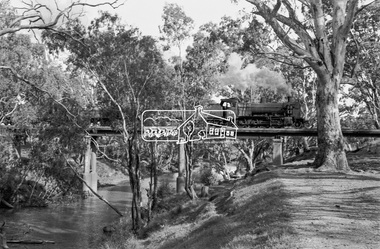 Eltham District Historical Society Inc
Photograph, Steam locomotive K-158 crossing the railway bridge over the Campaspe River at Rochester, Victoria, c.November 1963, 1963
It is the railway bridge over the Campaspe River at Rochester, Vic. original to the construction of the line. It was taken late on a Saturday morning and shows the regular goods train of that period approaching, then crossing the bridge. I originally planned to take just one view. The approaching train was first then it was a rapid run back along the raised river bank to get the broadside shot. I had little time to steady myself or properly check camera settings, hence the slightly soft focus etc. The train would eventually continue over the Echuca Iron Bridge into NSW. I think its ultimate destination was Deniliquin but not sure.Digital TIFF file Scan of 35mm Ilford FP3 black and white negative transparencygeorge coop collection, k-158, k-class steam locomotive (vr newport workshops), railway bridge, campaspe river, rochester -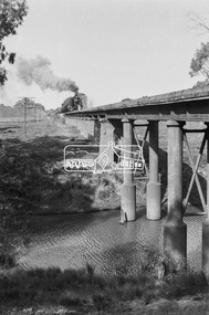
 Eltham District Historical Society Inc
Photograph, 19 Rockcliffe Street (Brougham Street entrance), Eltham, 3:30pm, 5 July 1967, 1967
Lot 6 L.P. 9499 at eastern most end of Brougham Street Property has since been subdivided and this access end is now 146 Brougham Street Photo taken by Russell Yeoman, Planning Department, Shire of Eltham In the 1954 Electoral Roll Ella Dunkel was listed as living in Diamond Street, Home Duties. In the 1963/1967/1968/1972/1977 electoral rolls she was listed at 19 Rockcliffe Road, Home Duties. Probate was granted 18 July 1979 (Wills and Probate Records. VPRS 28 (Probates) and VPRS 7591 (Wills). Public Record Office Victoria, North Melbourne, Victoria.)Polaroid photographPolaroid Manufacturer Code K603831 #7brougham steet, houses, rockcliffe street, eltham, ella dunkel -
 Eltham District Historical Society Inc
Photograph, 19 Rockcliffe Street (Brougham Street entrance), Eltham, 3:30pm, 5 July 1967, 1967
Lot 6 L.P. 9499 at eastern most end of Brougham Street Property has since been subdivided and this access end is now 146 Brougham Street Photo taken by Russell Yeoman, Planning Department, Shire of Eltham In the 1954 Electoral Roll Ella Dunkel was listed as living in Diamond Street, Home Duties. In the 1963/1967/1968/1972/1977 electoral rolls she was listed at 19 Rockcliffe Road, Home Duties. Probate was granted 18 July 1979 (Wills and Probate Records. VPRS 28 (Probates) and VPRS 7591 (Wills). Public Record Office Victoria, North Melbourne, Victoria.) 35mm colour positive transparency blue Agfacolour Service plastic mountSlide is marked 19 July 1967 but identical to Polaroid taken by Russell Yeoman at 3:30pm on 5 July 1967 Slide also inscribed E-B and Gp PSCbrougham steet, houses, rockcliffe street, eltham, ella dunkel -
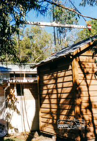 Eltham District Historical Society Inc
Photograph, Preparing the old Lock-up No. 17 for relocation from Youth Road to the Local History Centre at 728 Main Road, Eltham, March 2001, March 2001
The portable lock up at Eltham is not original to the site. The date of construction is unknown. It is a pre-fabricated design and each of the timber panels are individually numbered on the inside surfaces. It is amongst a large group of portable locks up,categorised as 'Portable Lock Up - Timber - Later' and also known as the "Casterton style", based on the only known plan for portable lock ups, built for the Casterton Police Station, in 1907. The later portables have been in use since the 1880s. It is not known how many lock ups of this type have been constructed in Victoria. At least 50 examples have been documented around the state. Of these, 42 are known to be extant.This lockup used to be located at the Police Station in Pryor Street and was then stored in Youth Road before being acquired for the Local History Centre 9 colour photographseltham, main road, police residence, local history centre, eltham district historical society, courthouse, youth road -
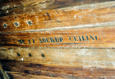 Eltham District Historical Society Inc
Photograph, Inside panels of No. 17 Lock-up, March 2001, March 2001
The portable lock up at Eltham is not original to the site. The date of construction is unknown. It is a pre-fabricated design and each of the timber panels are individually numbered on the inside surfaces. It is amongst a large group of portable locks up,categorised as 'Portable Lock Up - Timber - Later' and also known as the "Casterton style", based on the only known plan for portable lock ups, built for the Casterton Police Station, in 1907. The later portables have been in use since the 1880s. It is not known how many lock ups of this type have been constructed in Victoria. At least 50 examples have been documented around the state. Of these, 42 are known to be extant.This lockup used to be located at the Police Station in Pryor Street and was then stored in Youth Road before being acquired for the Local History Centre 2 colour photographseltham, main road, police residence, local history centre, eltham district historical society, courthouse, youth road -
 Eltham District Historical Society Inc
Photograph, Eltham Shire Office, shortly after duplication of Main Road, c.1968
Eltham Shire Council office built 1964 on the former site of Shillinglaw Cottage. In 1971 the offices were extended with a southern wing (to the left of the building) which housed the Eltham Library and planning offices. Taken shortly after widening of Main Road between Pitt Street and Elsa Court which was undertaken between February 1968 and August 1968. Image was most probably commissioned by Eltham Shire Council and taken by Hugh Fisher, photographer who operated from premises between Arthur and Dudely streets and was often contracted by the shire for official photographic work. The image was used in the August 1971 issue of Australian Municipal Journal This photo forms part of a collection of photographs gathered by the Shire of Eltham for their centenary project book,"Pioneers and Painters: 100 years of the Shire of Eltham" by Alan Marshall (1971). The collection of over 500 images is held in partnership between Eltham District Historical Society and Yarra Plenty Regional Library (Eltham Library) and is now formally known as the 'Shire of Eltham Pioneers Photograph Collection'. It is significant in being the first community sourced collection representing the places and people of the Shire's first one hundred years.Digital image and 120 format B&W negativesepp, shire of eltham pioneers photograph collection, eltham, main road, duplication, road widening, shillinglaw trees, local government -
 Glen Eira Historical Society
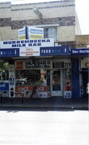
Photograph, Murrumbeena Road, 229, Murrumbeena, 2001
Originally labelled "Beauville Estate, Established 1936, Still Thriving 65 years on, 10th March 2001", the Beauville Estate Album contains colour photographs of houses in the Estate. They were taken around the time of the Beauville Estate’s 65th Heritage Celebration held on 10/03/2001 and donated to the Caulfield Historical Society shortly afterwards. Photographer unknown. From Glen Eira’s Heritage Management Plan by Andrew Ward (1996) Vol 2 p78: In Murrumbeena Road, the shops which form part of the estate are a simple cream brick row relieved by manganese bricks in bands across the upper storeys. City of Glen Eira’s Heritage Management Plan Vol 2 p79 (this is p84 of the pdf version) – HO12 Beauville Estate and environs, Murrumbeena: The Beauville Historic Area is important at the State level as the first large housing estate undertaken by the AV Jennings Construction Co, later Jennings Group Limited, Victoria’s largest home builder. It is important also as a very early estate development incorporating a range of features other than houses and including made roads, shops and recreation facilities. In this respect it was the forerunner of the comprehensively planned housing estate of the post war era. The estate is distinguished by its aesthetic values, as is the earlier and comparable Hillcrest Estate, which are formed by a combination of restrained diversity in house styles, with the exception of no. 30 in the emerging International style, and by a landscaped garden environment. Colour photograph of a section of a double storey, unpainted brick, commercial property containing shops at ground level all with awnings over the footpath. This specific property is a milk bar on street level with plate glass windows and door, colourful advertising and "229' in the top right section of the window. Shop signage says "MURREMBEENA MILK BAR". The upper storey brick residence features a large window, a flat roof and decorative two tone banded brickwork. MURREMBEENA (sic) MILK BAR / PK's / SANDWICH / BAR / MILK BAR & Sandwich Bar / 229 / SUB NEWSmurrumbeena, architectural styles, 1930's, inter war style, a.v. jennings, av jennings, jennings, beauville estate, murrumbeena road, milk bars, commercial establishments, flats, sir albert victor jennings, a v jennings construction co, beauville estate heritage area, glen eira city council, architectural features, jennings group limited, land subdivision, beauville historic area, shops, brick features, window displays, advertising signs, murrembeena (sic) milk bar -
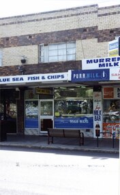 Glen Eira Historical Society
Photograph, Murrumbeena Road, 229A, Murrumbeena, 2001
Originally labelled "Beauville Estate, Established 1936, Still Thriving 65 years on, 10th March 2001", the Beauville Estate Album contains colour photographs of houses in the Estate. They were taken around the time of the Beauville Estate’s 65th Heritage Celebration held on 10/03/2001 and donated to the Caulfield Historical Society shortly afterwards. Photographer unknown. From Glen Eira’s Heritage Management Plan by Andrew Ward (1996) Vol 2 p78: In Murrumbeena Road, the shops which form part of the estate are a simple cream brick row relieved by manganese bricks in bands across the upper storeys.City of Glen Eira’s Heritage Management Plan Vol 2 p79 (this is p84 of the pdf version) – HO12 Beauville Estate and environs, Murrumbeena: The Beauville Historic Area is important at the State level as the first large housing estate undertaken by the AV Jennings Construction Co, later Jennings Group Limited, Victoria’s largest home builder. It is important also as a very early estate development incorporating a range of features other than houses and including made roads, shops and recreation facilities. In this respect it was the forerunner of the comprehensively planned housing estate of the post war era. The estate is distinguished by its aesthetic values, as is the earlier and comparable Hillcrest Estate, which are formed by a combination of restrained diversity in house styles, with the exception of no. 30 in the emerging International style, and by a landscaped garden environment. Colour photograph of a section of a double storey, unpainted brick, commercial property containing shops at ground level all with awnings over the footpath. This specific property is a fish and chip shop. The upper storey brick residence features a curtained window, a flat roof and decorative two tone bands of brickwork. It has a large street seat on the footpath out front.BLUE SEA FISH & CHIPS / TAKE AWAY FOODmurrumbeena, architectural styles, 1930's, inter war style, a.v. jennings, av jennings, jennings, beauville estate, murrumbeena road, milk bars, commercial establishments, flats, fish & chip shops, sir albert victor jennings, a v jennings construction co, beauville estate heritage area, glen eira city council, architectural features, jennings group limited, land subdivision, beauville historic area, brick features, restaurants -
 Rutherglen Historical Society
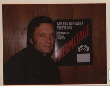
Image, 1970s
Photo of Harry Tinson who was winemaker at Baileys in Glenrowan from 1968 until 1982. An ageing Alan Bailey (greatgrandson of founder Richard Bailey) sold the winery to Davis Consolidated Industries (mainly a gelatine producer). At the time Harry Tinson, with a Master’s degree in physical engineering, was in the corporate planning department of Davis. The board had decided it wished to diversify into wine production and Tinson was charged with the responsibility of finding a suitable target. He came up with Baileys, and was instructed to negotiate the purchase of a 50 per cent share in the business. Bailey said “all or nothing” ! (James Halliday – news article 22/01/2011)Colour transparency photograph of a man standing in front of a timber panelled wall, featuring an advertising poster for Baileys Bundarra Vineyardswineries, north east victoria, wine industry, baileys, winemaker -
 Otway Districts Historical Society
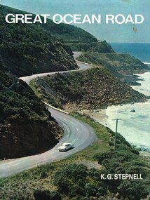
Book, Rigby Limited, Great Ocean Road. K.G. Stepnell, 1972
The Great Ocean Road may be the only road in the world which was built as a war memorial. In 1916, much of Australia was poorly served by roads, and it was suggested that returning servicemen could be given worthwhile employment by building roads in isolated areas. The plan was taken up for the Great Ocean Road, and work was dedicated to the memory of men who had fallen in World War 1. The road itself is a great feat of engineering. It wind around some of Australia's most rugged coastline. Now it is one of the world's most scenic routes, crossing gorges, along precipitous cliffs, through dense forests, and over steeply rolling coastline country.Great Ocean Road. K.G. Stepnell. 1st ed. Rigby Limited; Adelaide (S.A.); 1972. 36 p.; illus., maps. Hard cover. ISBN 0 85179 371 1great ocean road; roads; fishing; timber; twelve apostles; -
 Port Fairy Historical Society Museum and Archives
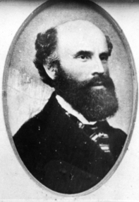
Photograph, Billing, Nathanial
Nathanial Billing was born in Brightwell Oxfordshire England on 5th May 1821. He emigrated to Australia on the ship 'Ballarat' in 1853 on arrival in Victoria he entered Government service and worked in the Warrnambool and Belfast districts until 1857. He then left the Public Service and commenced private practice. In 1850 Nathaniel and Henrietta Heybourne were married on July 17 at Hillingdon Parish, Middlesex, England. In Belfast Victoria he designed St Johns Church of England, the Bank of Australasia, and worked on St Patricks Catholic church from plans by English architect Hansom. He died on January 29 1910 in St Kilda, Victoria, Australia. Architect of 3 significant public buildings in Belfast/Port FairyBlack and white portrait of gentleman with black full beard and striped cravatpioneer, settler, portrait, people, architect, st johns church of england,, st patricks catholic church, bank of australasia, nathanial billing -
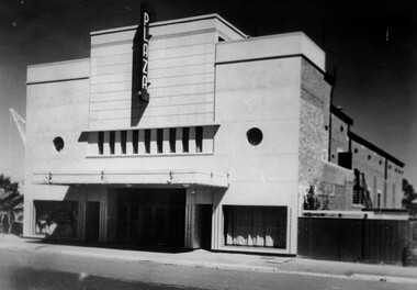 City of Kingston
Photograph - Black and white, c. 1948
Located in the southeast Melbourne district of Ormond. The Ormond Theatre was opened in the late-1920’s with 720 seats in stalls and circle. There was no ceiling in the auditorium, which allowed for the steel roof trusses to be seen. In 1930 a Western Electric(WE) sound system was installed. In 1940 it was remodelled in a simple Art Deco style to the plans of architectural firm Marsh & Michaelson. It re-opened in 1941 with 995 seats. By 1946 it was operated by Albert Park Cinemas Property Ltd. The Plaza Theatre was closed on 30th November 1958. It was converted into a carpet showroom which was still operating in late-1984. The building has since been demolished.Black and white photograph depicting the art deco facade of the newly refurbished Plaza Theatre, Ormond. There are no buildings either side of the theatre which highlights its large size.Black printed text on white round sticker adhered to reverse: 187 Handwritten in red ink on reverse: 72%theatre, movies, entertainment, plaza, suburbs -
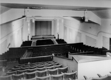 City of Kingston
Photograph - Black and white, c. 1948
Located in the southeast Melbourne district of Ormond. The Ormond Theatre was opened in the late-1920’s with 720 seats in stalls and circle. There was no ceiling in the auditorium, which allowed for the steel roof trusses to be seen. In 1930 a Western Electric(WE) sound system was installed. In 1940 it was remodelled in a simple Art Deco style to the plans of architectural firm Marsh & Michaelson. It re-opened in 1941 with 995 seats. By 1946 it was operated by Albert Park Cinemas Property Ltd. The Plaza Theatre was closed on 30th November 1958. It was converted into a carpet showroom which was still operating in late-1984. The building has since been demolished.Black and white photograph of the theatre inside the Plaza Theatre. The photograph has been taken at the rear of the theatre and looks down over the three tiers of seating toward the screen.Black printed text on white round sticker adhered to reverse: 186 Handwritten in red ink on reverse: 77%theatre, movies, entertainment, suburbs -
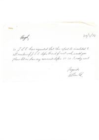 Melbourne Legacy
Document, Steering committee - Future of Residences
Draft report of the Steering Committee (Residences) dated 29/3/74 on the accompanying note, which was addressed to Hugh (Legatee H. Rodgers) and signed Allan Q. (Legatee A. Quayle). The Steering Committee was in favour of demolishing and re-building Blamey House in stages: 1. constructing motel type units on SW corner of the site, 2. Demolishing Blamey House 3. Moving occupants in from Stanhope 4. Moving occupants from Harelands to Stanhope and selling Harelands. The plan would also provide future accommodation for widows in the long term. These recommendations were never implemented. See also Cat. No. 01677.Part of the history of Melbourne Legacy's involvement with residential care for children.White foolscap paper x 5 pages with black type. Two holes punched for filing. 2 handwritten add-ons, one black biro on unpunched white paper, the second black biro on faintlined paper with double holes punched. In black biro: Page 1 line 4 - 'the' inserted Page 1 3.1.2 'u' deleted Page 2 - 3.2 (A) and (B) inserted Page 3 - 3.3 split into (A) and (B) Page 3 - 4.1.2 crossed out and rewritten on separate sheet Page 3 - 4.2.2 'Move occupants from 'Stanhope' into the new complex' added. Page 4 - 4.2.3 Crossed out and rewritten as 'Move the occupants from 'Harelands' to 'Stanhope' and sell 'Harelands'. Page 4 - 6.1.1 'However, the Page 4 - final para 'detail of what these funds might be available' replaced with 'detailed information on the availability of these funds' Page 5 - 6.1.3 'implemented' replaced 'put in hand Page 5 - 6.1.3.2 changed to read 'Suitable short-term housing of our Junior Legatees at a standard commensurate with the responsibility of Legacy'.residences, review, blamey house