Showing 23443 items
matching emu-creek
-
 Tarnagulla History Archive
Box of Donald Clark's Research Notes, Donald Clark's Research Notes, circa 1960s-2000s
Donald Clark Collection. Blue-grey archive box containing research notes of Donald Clark. Within this set are multiple archival folders with the following subject matter: Hotels Gold, prospecting & mining Peace Picnic Street lighting Churches Cemetery Poems Shire of Bet Bet Chinese Clubs Police Transport Local businesses/premises Local people Post Offices Previous history work / previous history enquiries Back To Tarnagulla events Victoria Theatre / Entertainment Schools Water and waterways Early town Mapping and geography Photocopies of photos Miscellaneous Rail Link Centenary Newbridge Eddington Waanyarra Bet bet (town) Llanelly Murphy's Creek / Irishtown Laanecoorie Military Service Fire Brigade Tarnagulla Landmarks / Places of Interest Family Histories Births, Deaths, Marriage info Transcript of St. Saviour's Records A plastic pocket containing duplicate copies of local history images held elsewhere in the collection. The contents of these files were research notes compiled by Donald Clark from his local history research about Tarnagulla and district. tarnagulla & district, donald clark, research -
 Melbourne Tram Museum
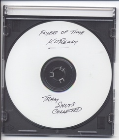
Photograph - Compact Diskette with photographs, Kevin O'Reilly, "Flyers of Time K'O'Reilly - Tram shots collected", 2012
CD (Compact Diskette for use in computers) (108mm diameter plastic disc with plastic case and cover) containing a series of aerial photographs of Ballarat (2) and Melbourne ( 15 ) Disc has the hi-resolution TIF files and jpg file. Files in order on CD: Ballarat 5 - copy sent to the Ballarat Tramway Museum - images on this record as tiff files. Ballarat - ditto Eliz St - see htd136 for image Kew Barkers Road - see htd137 for image Kew Burke Rd - see htd138 for image Kew Junction - see htd139 for image Merri Creek - see htd140 for image Richmond 6 - see htd141 for set of three images Richmond 7 - see htd142 for image Richmond - see htd141 for set of three images Richmond3- see htd141 for set of three images Royal Park 2 - see htd143 for image Sandringham - see htd144 for image Scotch - see htd145 for image Spencer - see htd146 for image St Kilda 1 - see htd147 for image St Kilda - see htd148 for imagetrams, tramways, melbourne -
 The Beechworth Burke Museum
Photograph - Photograph - Reproduction, 1890-1900
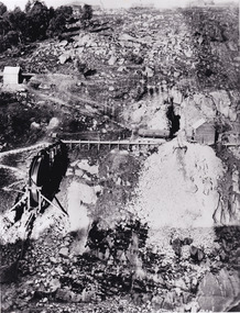
The photograph appears to depict the of the entrance to the Rocky Mountain Tunnel. The Rocky Mountain Tunnel runs from opening of the tunnel, underneath the Beechworth town, to the Gorge. This tunnel drained the excess water from the upper Spring Creek Goldfield to allow for mining access in the area. The Rocky Mountain Co. blasted through the granite rock to create the original 400ft-long tunnel in 1859, but between 1867 and 1871, the Rocky Mountain Gold Sluicing Co. widened and extended it. At its completion, it measured 14ft deep, 6ft wide, and almost half a mile long. The mining surveyor at Beechworth called it 'without doubt, the greatest undertaking of the kind in the colony'. When the company became the Rocky Mountain Extended Gold Sluicing Co. in the mid-1870s, they continued the tunnelling work. The work was reportedly vital to mining being able to continue at Beechworth and may have established world records in tunnelling through hard rock. The entrance at the Gorge side of the tunnel can be seen from the Beechworth Gorge Walk. The tunnel continues to be an outfall drain for the lake and the town.The search for gold is ingrained into the history of Victoria and therefore, images like this one which portray an open cut sluicing site can reveal important information for society and technology for the date when the photograph was taken. This image is of important historical significance for its ability to convey information about sluicing and the methods used to find gold in the late 1800s and early 1900s. It also shows a location where sluicing was undertook which provides insight into the impact of sluicing on the environment at a time when it was done. The Burke Museum is home to a substantial collection of Australian mining photographs which can be used to gain a deeper understanding into life on the gold fields, technology used in mining, the miners themselves and the impact of the gold digging on the environment.A black and white rectangular reproduced photograph printed on matte photographic paper.7814beechworth, beechworth museum, burke museum, australian museum, mining, rocky mountain mining co., rocky mountain mining company, mine, mining company, rocky mountain mine, mine entrance, rocky mountain, gold, gold mining -
 Kiewa Valley Historical Society
Photograph - 8 Black and white photographs - SECV, Unknown
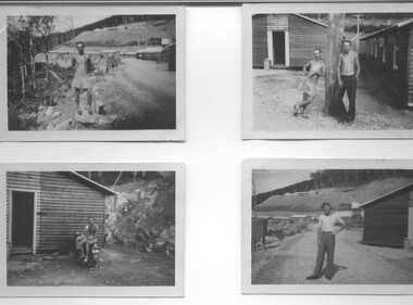
All eight photographs have been taken at a workmen's camp erected by the State Electricity Commission to house workmen during the construction of the Kiewa Hydro Electric Scheme. These were established in close proximity to various work centres - Junction Camp at Bogong Village, three camps at Mt. Beauty, West Kiewa, Clover Dam and Clover Flat, Howman's sawmill and Howman's Gap, Rocky Valley, Langford's Gap, Pretty Valley, Mountain Creek and Big Hill. These photos have not been identified as to which camp they are taken but typical of the type of accommodation for wages personnel. They followed a general design and layout. There was a mess and recreation hall as well as a building for general trading and postal facilities (this conducted by proprietors of trading stores in Mt. Beauty and Bogong). Originally the rooms accommodated 2 men but later there was a demand for single rooms - the floor size then being 10 feet x 8 feet and furnished with a bed, small table and chair and cupboard with hanging space. The first camps were erected in 1940 and the last was removed in 1962.These photographs are of historical significance as they show the type of accommodation provided for wages personnel working on the Hydro Electric Scheme between 1940 and 1960.Eight small black and white photographs of unknown person and workmen's camp.All photos have been stamped on the back - Two "965U" in red, four "S80 " in green (indistinct) and two "141" in red.workmen's camps, kiewa hydro electric scheme, accommodation, secv, camps on kiewa hydro electric scheme, west kiewa -
 Eltham District Historical Society Inc
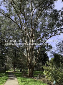
Photograph - Digital Photograph, Significant Tree: Eucalyptus, Stokes Orchard Linear Park, Eucalyptus Road, Eltham, 4 September 2020
The tree is located on the eastern side of Eucalyptus Road, Eltham in the linear park which runs through the Stokes Orchard Estate, approximately 200m from Eucalyptus Road. This is the path of an old creek which originates from near Nyora Road and Stokes Place. Aerial photography taken in November 1931 shows several reasonably well-developed trees, possibly of 20 to 30 years of age beside the water course. The water course and trees were retained in the orchard and these old trees remain standing as of 2024. However, in 2023 Council received a complaint regarding a potential risk with the largest tree even though it had not been known to cause any issue over recent decades but given the public risk concern, Council conducted an assessment and cut it down leaving approximately 10m of the trunk still standing. The major limbs were left 'scattered' around the base for wildlife habitat. The tree remains alive and is now rapidly becoming a tall bushy shrub. The age of the tree is in in excess of 125 years.stokes orchard estate, significant tree, eucalyptus road, eltham, eucalyptus tree -
 Eltham District Historical Society Inc
Slide - Photograph, On the Eltham Road, Walter Withers (1906), Heidelberg School Artists Trail, Alistair Knox Park, Eltham, c.Nov. 2001
The Heidelberg School Artists Trail was established in about 1999 with about 52 signs across four local governemnt areas including Nillumbik and Banyule. It extends from Heidelberg through Eltham and Warrandyte and to the Dandenongs. It features signs depicting paintings of artists in the location in which they were painted. This one acknowledges "On the Eltham Road", 1906. Transcription of the text states: "In this cheerful rural landscape, Walter Withers has captured the spirit of early Eltham. Eltham was a quiet, sleepy village, where geese wandered up the main Road and the locals either walked or rode their horses or bicycles around the township. Walter Withers was known to load up his bicycle with his collapsible easel, folding stool, paint box, water bottle and canvases, and would head off for a day’s painting. He was also known for his walking, as was his family, and they became known as the ‘Walking Withers’ Part of a slide show presentation "A Trip Down the Diamond Creek" by Russell Yeoman to the Eltham District Historical Society meeting of 14 Nov. 200135mm colour positive transparency Mount - Black and Whiteeltham, alistair knox park, heidelberg school artists trail, on the eltham road, public art, sign, walter withers -
 Eltham District Historical Society Inc
Negative - Photograph, Allwood, Hurstbridge, 1899
Allwood, Hurstbridge, 1899. Gray family in the garden in front of the Victorian style Allwood house with lace iron work on the verandah. Left to Right: - , - , William George Gray (3rd from left),. Frances Ellen Gray (nee Hurst) and William Hurst Gray (on lap). Carrie Sharp, Rob Sharp, Holmstrong. Frederick and Catherine Hurst relocated this Victorian style weatherboard home from an inner Melbourne suburb to its present site on their Allwood property. Mr Charles Verso, builder and farmer, reassembled and refurbished the home for the Hurst’s. In 1897 Frederick and Catherine’s daughter, Frances Ellen, married William (Bill) George Gray of Cottlesbridge and the newlyweds moved into the new house. Frederick and Catherine Hurst moved into a little cottage, ‘Mia Mia’, on the other side of the Diamond Creek. William and Frances Gray established Allwood Nursery and by 1900 most of the Allwood property was under orchard, largely apples, pears, cherry plums and peaches. They also developed an extensive nursery, growing seedling stock for supply to other local orchardists and the overseas market. Cross Ref: Sepp_1022 This photo forms part of a collection of photographs gathered by the Shire of Eltham for their centenary project book, "Pioneers and Painters: 100 years of the Shire of Eltham" by Alan Marshall (1971). The collection of over 500 images is held in partnership between Eltham District Historical Society and Yarra Plenty Regional Library (Eltham Library) and is now formally known as 'The Shire of Eltham Pioneers Photograph Collection.' It is significant in being the first community sourced collection representing the places and people of the Shire's first one hundred years.Digital image 4 x 5 inch B&W Negshire of eltham pioneers photograph collection, hurstbridge, allwood, carrie sharp, frances ellen gray (nee hurst), holmstrong, hurst family, rob sharp, william (bill) george gray, william hurst gray -
 Melton City Libraries
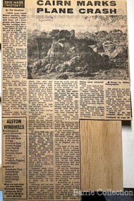
Newspaper, Cairn marks plane crash, 1976
"On 5 July 1936, locals in Melton South saw a plane emerge from behind clouds above the railway station, in heavy wind and rain. Engine roaring, the plane went into a spin and disintegrated into pieces in mid-air, before crashing to the ground near Arnold’s Creek. The pilot, young Australian aviator Jimmy Melrose, and a passenger, Alexander Campbell, were killed.Jimmy Melrose was a popular figure in international aviation, having been the youngest and only solo pilot to finish the London to Melbourne Centenary Air Race in 1934. His death, at the age of just twenty-two, caused an outpouring of sorrow. He was honoured with a state funeral two days later at St Paul’s Cathedral in Melbourne, which was attended by thousands of people. Locals Maisie Arthur, Ted Wickham and Bill Cahill gave eyewitness accounts of the accident to the authorities, and an inquest found that it was the result of structural failure and poor weather. A cairn erected by locals near the scene was reconstructed by the Melton and District Historical Society in Brookfield, opposite the Melrose Memorial Reserve, on the 40th anniversary of the crash in 1976".Regional Gazette article of a cairn erected by locals near the scene of the plane accident which involved Jimmy Melrose, and passenger, Alexander Campbelllocal significant events, landscapes of significance -
 Wodonga & District Historical Society Inc
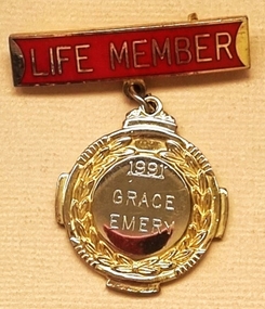
Badge - Life Member Wodonga Swimming Pool Committee - Grace Emery
Mrs Barbara Emery, born in Beechworth in 1914 was one of the original members of the Wodonga community who formed a Committee and lobbied for the building of a swimming pool in Wodonga. This was prompted after many near misses and a drowning at the popular swimming spot in Wodonga Creek. She and her husband Bob, along with other Committee members lobbied the Wodonga Council and were finally able to negotiate land which fronted onto Stanley Street, Wodonga. Members of the Committee worked tirelessly to fund raise and also to build the pool itself. Countless working bees were organised to complete the construction and surrounds. The pool opened on 12th December 1959. Mr Bob Emery became the manager and Grace ran the kiosk for many years. Later reflecting on her life in the Wodonga community Mrs Emery stated, “To get the pool was a highlight in my life, the satisfaction that we could save lives.” After years of heated discussion about the future of the Stanley Street pool and the construction of a new pool, it finally closed on 31 March 2012. Mrs Emery died in Wodonga.This membership badge is significant because it was awarded to a member of the Wodonga community to recognise her service.A gold plated and enamelled badge attached to a red enamelled bar. The badge is engraved on the front.On bar;- LIFE MEMBER On badge; 1991 GRACE EMERYgrace emery, wodonga swimming pool, life membership grace emery -
 Ballarat Heritage Services
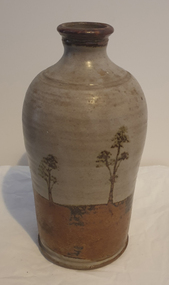
Photograph - Australian Studio Pottery, Ceramic Bottle by Maldon Pottery
Maldon Pottery was established in 1973 by Neville Wilson (1946-1996), Tom Metcalf (1948- ) and Graham Masters (1950- ) on Barringhup Road, Maldon, Victoria. Tom Metcalf and Graham Masters Masters graduated from Bendigo College of Advanced Education all Bendigo graduates. Wilson ) He was a skilled drawer and did all the brushwork. Metcalf (1948- ) graduated in 1968, did two years' work experience at Non-porite in Melbourne, then worked as a thrower and decorator at Bendigo Pottery from 1971-73. He is T.M. on Epsom ware. Masters (1950- ) graduated in 1973 and established the Enterprise Pottery at Myers Flat with Morris Hesse in 1974, so must have joined the partnership later than the others. He left in 1984 to set up his own Sweenies Creek Pottery. Metcalf left in the late 1980s, leaving Wilson to operate the pottery by himself until his death in 1996. As well as using the Maldon Pottery stamp, Wilson signed some of his work with his name or an impressed 'N'. Photograph of a hand thrown ceramic bottle, with glaze design depicting an Australian landscape in the 'continuous trees' pattern.maldon pottery, ceramics, australian studio pottery -
 Marysville & District Historical Society
Postcard (item) - Colour photographs, Nucolorvue Productions, A Souvenir of Beautiful Marysville-12 Specially Selected Views in Full Colour, 1950's
An envelope of 12 colour photographs of attractions in and around Marysville in Victoria.An envelope of 12 colour photographs of attractions in and around Marysville in Victoria. These photographs were produced by Nucolorvue Productions in Mentone, Victoria.A Souvenir of Beautiful MARYSVILLE 12 Specially Selected Views in Full Colour Marysville, Victoria, Australia Marysville, 60 miles from Melbourne, is one of nature's/ lovely beauty spots. The invigorating mountain air helps the/ visitor to enjoy the many delightful walks amongst the tall/ timber, or through the fern glades. Apart from many excellent walking trips, Marysville district/ offers ample scope for car trips to the nearby Cumberland Forest,/ Buxton, Narbethong, or the Taggerty Valley. Skiers find Lake Mountain an attraction in the winter, whilst/ the hiker finds ample for his needs in the numerous mountain/ areas. Huge Eucalypt trees, revealing their ramrod straightness up/ to 300 feet in height, are a fitting background to the many/ beautiful creeks and waterfalls. PUBLISHED BY NUCOLORVUE PRODUCTIONS, MENTONE, VICTORIA.nicholl's lookout (image 1), eildon weir (image 2), road to lake mountain (image 3), foot of steavenson falls (image 4), steavenson falls (image 5), bush scene near marysville (image 6), bush track marysville (image 7), bridge and chalet and crossways marysville (image 8), log cabin at marysville (image 9), black spur (image 10), taggerty river (image 11), highest known hardwood tree (image 12), marysville, victoria, nucolorvue productions, postcard, souvenir -
 Marysville & District Historical Society
Postcard (item) - Colour photographs, Nucolorvue Productions, A Souvenir of Beautiful Marysville-12 Specially Selected Views in Full Colour, Unknown
An envelope of 12 colour photographs of attractions in and around Marysville in Victoria.An envelope of 12 colour photographs of attractions in and around Marysville in Victoria. These photographs were produced by Nucolorvue Productions in Mentone, Victoria.A Souvenir of Beautiful MARYSVILLE 12 Specially Selected Views in Full Colour Marysville, Victoria, Australia Marysville, 60 miles from Melbourne, is one of nature's/ lovely beauty spots. The invigorating mountain air helps the/ visitor to enjoy the many delightful walks amongst the tall/ timber, or through the fern glades. Apart from many excellent walking trips, Marysville district/ offers ample scope for car trips to the nearby Cumberland Forest,/ Buxton, Narbethong, or the Taggerty Valley. Skiers find Lake Mountain an attraction in the winter, whilst/ the hiker finds ample for his needs in the numerous mountain/ areas. Huge Eucalypt trees, revealing their ramrod straightness up/ to 300 feet in height, are a fitting background to the many/ beautiful creeks and waterfalls. PUBLISHED BY NUCOLORVUE PRODUCTIONS, MENTONE, VICTORIA.nicholl's lookout (image 1), eildon weir (image 2), road to lake mountain (image 3), foot of steavenson falls (image 4), steavenson falls (image 5), bush scene near marysville (image 6), bush track marysville (image 7), bridge and chalet and crossways marysville (image 8), log cabin at marysville (image 9), black spur (image 10), taggerty river (image 11), highest known hardwood tree (image 12), marysville, victoria, nucolorvue productions, postcard, souvenir -
 Parliament of Victoria
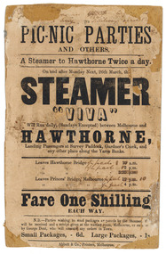
Flyer for the steamer Viva, Abbott & Co., Printers, c.1860
The "Viva" was a steamboat operated by George Dent that ran on the Yarra River between Princes Bridge and Hawthorn Bridge from 1860-1861. Printer flyer pasted onto cardboard advertising ferry services between Melbourne and Hawthorne [sic]. Corrections to ferry departure times are in black handwritten ink. Flyer has losses around edges and stains from 'blue-tack' verso. Black ink, printed recto: "PIC-NIC PARTIES/ AND OTHERS./ A Steamer to Hawthorne Twice a day./ On and after Monday Next, 26th march, the/ STEAMER/ "VIVA"/ Will Run daily, (Sundays Excepted) between Melbourne and/ HAWTHORNE,/ Landing Passengers at Survey Paddock, Gardner's Creek, and/ any other place along the Yarra Banks./ Leavers Hawthorne Bridge 10 a.m./ 2 p.m./ 5.30 p.m./ Leaves Princes' Bridge, melbourne 12 p.m./ 4 p.m./ Fare One Shilling/ EACH WAY./ N.B.-Parties wishing to send packages or parcels by the Steamer th(?).../ will be received and a receipt given at the waiting room, Melbourne, or on board.../ by George Dent, who will execute any orders in Town./ Small Packages, - 6d. Large Packages, - 1s/ Abbot & Co., Printers, Melbourne.viva steamboat, dent, george, hawthorne, yarra river, princes bridge, melbourne, survey paddock, gardner's creek -
 Eltham District Historical Society Inc
Photograph - Digital Photograph, Marguerite Marshall, Smith Dam, Karingal Drive, Eltham, 19 September 2006
The dam at the entrance to the Nerreman Gateway in Eltham was built according to an internationally acclaimed theory developed by the builder's father. In 1920, Victorian engineer B.A. Smith was awarded the American Society of Civil Engineers J. James R. Cross Gold Medal for his Technical Paper titled 'Arched Dams'. It was the first time this medal had been awarded outside the United States. The concrete arched dam across the Eltham West Drain was built in 1940 by B.A. Smith's son and engineer, D. B. (Bernie) Smith to water the 24 acre (9.75 ha) hobby farm owned by himself and new wife, Isa Smith. Upon completion of the dam a pump-house was constructed beside the creek but before the water could be pumped up the hill they had to dig a trench and lay 500m of 100mm water main to an elevated holding tank. The Smiths made the pump-house their home for several years until they constructed their home at the top of the hill overlooking Eltham and views extending to Kinglake. Following Bernie's death in 1983, Nerreman Park was subdivided between 1993 and 1995. Gordon Ford designed the landscaping and the pump-house was demolished. Covered under Heritage Overlay, Nillumbik Planning Scheme. Published: Nillumbik Now and Then / Marguerite Marshall 2008; photographs Alan King with Marguerite Marshall.; p137 The dam at the entrance to the Nerreman Gateway in Eltham, was built according to an internationally acclaimed theory developed by the builder’s father. In 1920, Victorian engineer B A Smith was awarded the American Society of Civil Engineers J. James R. Croes Gold Medal, for his Technical Paper titled Arched Dams. It was the first time this medal had been awarded outside America. An international example of the application of Smith’s work can be found in the design of the Hoover Dam on the Colorado River, Nevada, USA. Built between 1930 and 1936, it is recognised by the ASCE as one of ‘America’s Seven Modern Civil Engineering Wonders’.1 The concrete arched dam across the Eltham West Drain was built by B A Smith’s son and engineer, D B (Bernie) Smith. Bernie’s dam followed his father’s theory, having a curvature that takes maximum advantage of concrete’s great strength in compression. The water load is carried into the abutments because of this curvature, which permits a wall thickness of only 225 millimetres thick at its crest, despite the dam’s capacity of more than 4.5 megalitres. The Eltham dam was designed to water the 24 acre (9.75 ha) hobby farm belonging to newly married couple Bernie and Isa Smith. Bernie, from Armadale, and Isa, from a farm at Tyntynder near Swan Hill, were attracted to the hilly topography and the creek running through the property. It extended from Ryans Road, Eltham, to Karingal Drive, Montmorency and was adjacent to Meruka Park. The Smiths named it Nerreman Park using the Aboriginal word Nerreman meaning ‘River Bend’ as their creek had a pronounced bend.2 In 1940 the first thing Bernie did was to build a dam, and with Isa’s help, a pump-house, to secure a water supply for their cattle, pigs, chickens, orchard and vegetable gardens. It was also available for the fire-plugs, which they placed all over the property in case of bushfire. The couple built the pump-house beside the creek and installed a Tange three-plunger pump, which had originally supplied the City of Wodonga with water. But before the Smiths could pump water up the hill from the dam they had to dig a trench and lay about 550 yards (500m) of a four-inch (100mm) water main up to an elevated holding tank. The trench was dug with a single furrow plough drawn by an old draught horse. Living in rough conditions did not deter the Smiths, who made the pump-house their home, where they still lived when their first child was born in 1944. They later built their home at the top of their property overlooking Eltham, with magnificent views to Kinglake, the Dandenong Ranges and Melbourne. From 1946 it took them almost 20 years to complete the 36-square house with its 12-foot (3.6m) high ceilings. Material for the concrete roof and walls faced with sandstone, was ripped out of the ground on their property by plough pulled by tandem Clydesdale horses. Isa was a strong woman – two days before their second child was born – she set three huge sandstone boulders in place in the bottom wall of the garage. She also mixed all the cement for the house. A collapsed kitchen wall did not discourage her from rebuilding it in a week, while her husband was away working in the country. She later recalled: ‘We stood back to admire this beautiful wall we’d built and while we were looking at it, it came tumbling down’.3 Following Bernie’s death in 1983, Nerreman Park was subdivided, between 1993 and 1995. Local Gordon Ford designed the landscaping and the pump-house was pulled down. But the dam remains as a reminder of exceptional engineering4 – and of a remarkable couple.This collection of almost 130 photos about places and people within the Shire of Nillumbik, an urban and rural municipality in Melbourne's north, contributes to an understanding of the history of the Shire. Published in 2008 immediately prior to the Black Saturday bushfires of February 7, 2009, it documents sites that were impacted, and in some cases destroyed by the fires. It includes photographs taken especially for the publication, creating a unique time capsule representing the Shire in the early 21st century. It remains the most recent comprehenesive publication devoted to the Shire's history connecting local residents to the past. nillumbik now and then (marshall-king) collection, eltham, karingal drive, smiths dam, bernie smith, gordon ford, isa smith, nerreman gateway, nerreman park estate, dams -
 Kiewa Valley Historical Society
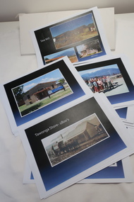
Coloured photographs on paper - Back to Tawonga 2010
These photos were collected and copied by Di Edmondson for the 'Back To Tawonga' Event in 2010 when she launched her book "Tawonga Remembers".An historical photographic collection of Tawonga and its surrounds, places and people up to 20101. Saw Mill - Mill house 2. The Rock Pool 3. People at the Rock Pool x 2 4.Old Saw mill 5. Back to Tawonga Celebrations x6 6. Tennis Curts opposite the Tawonga Store, Bakery in the background 7. Bowling Club 8. Old Guide Hall 9. The Old Boarding House 10. Old Fire Brigade Shed 11. Building the New Tawonga Memorial Hall 12. Tawonga Go Kart Track - 1960s 13. Tawonga Pony Club 1969 State Championships 14. Tawonga Recreation Reserve Newspaper article 15. The Damm Children 19. 1980s Brian Edmondson, Geoff Edmondson, Mick Harvey, David Piera. Geoff Edmondson's car 20. Tawonga Speedway Track - 1970s Mick Harvey and Paul Harkin's car 21. 2000 22. Tawonga Sports Vera Ryder and Allie Briggs 23. Tawonga School Photos x8 24. Harry Cooper's Farm Looking South 25.View from Edmondson's Farm - looking north 26. Mount Emu 27. St Aiden's Debutante Ball 27. Grand Opening Ball 1961 Tawonga Hall 28. The Kiewa Valley Road at Tawonga. Vic. 29. Tennis Courts opposite the Bogong Hotel 30.Opening of the new Toilet Block in Pioneer park 31. Old Tawonga Store x 3 32. Tawonga Memorial Hall 33. Anglican Church, St Aiden's x 2 34. Motor Khana held at Recreation reserve 35. 1970 State Champioships Team 36. Kiewa Valley School Sports at Dederang 37. Miscellaneous photos x27 Some photos have headings and some headings have been writtentawonga remembers, back to tawonga 2010, di edmondson -
 Bendigo Historical Society Inc.
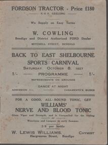
Document - BACK TO EAST SHELBOURNE SPORTS CARNIVAL, 8 October, 1927
Back To East Shelbourne Sports Carnival, Saturday, October 8, 1927. Programme. Refreshments on grounds, dance at night. 1/- Casamento's Buses. Executive Committee: President; W Harris. Vice-President; M De Araugo. Messrs. E Wright, A D Holden, W Hamilton, J Bartels, J Hinck, and H Hinck. Hon. Sec.; H M Burke. Asst. Hon. Sec.; G H Marshall. Ladies; Mesdames J Bartels, H Burke, G H Marshall, E Pocock, R Vines, and E Wright. General Committee; In addition to the above, Messrs. E Pocock, J De Araugo, F J Roberts, and W Marshall, Mesdames W Harris, A Holden, J De Araugo, F J Roberts, and Miss Pocock. Officials Judges: Messrs. T D Cairns, J Craven, and Geo. Hogben. Handicappers: Mr P Davidson (Northern District Walker's Assn.) Starter: Mr W Harris, M De Araugo, J Hinck, H Hovenden, E Pocock, W Hamilton, F J Roberts, A D Holden. Timekeeper: Mr H Hinck. Patrons: Cr, J Bartels, Nuttall & Clarke, Mrs D Punton, R S V Cocking, J Murray, and A Wells. Next 8 pages contain information on the history of East Shelbourne beginning with; This district is situated about ten miles west of south-west of Bendigo on Back Creek or Spring Creek, which received its names from the early diggers of Bendigo who, through shortage of water, were compelled to puddle at Bullock Creek or further 'back,' hence Back Creek; and because of the number of springs it contained - Spring Creek. Among the first to settle, in 1860, were Messrs. John Jenkinson, J Kilgour, T Connelly, G Nichols, R Fox, (who married Mrs James Jenkinson), Kenny, J Roberts, J Genders, J Curry, G Nevinson, Bartram, J Geary, A Nicholl, H Spencer, W Saunders, Mrs Prichard, and J Stansfield. History of East Shelbourne continues . . . Events held were Boy's (State School) Bicycle Race, Stepping the Distance (Gents), Stepping the Distance (Ladies), Bowling at the Stump, Kicking Football Through Hoop, Sheaf Toss, Bucket Ball, Sheffield, Children's Relay Race, Men's Potato Race, Tilting Rings, on Bikes, Walking Contest 1 mile, Car Race through pegs, Slow Bicycle Race 50 yards, Handicap Bicycle Race 2 miles, Tilting Rings in Cars, High Jump, Ladies' and Gent's Cigarette Race, Weight Guessing. Prizes were awarded for first and second placing of these events.In 1923, a Sports Carnival was held in the precincts of what was then a water reserve, situated south of the State School. The area was reserved for watering purposes on 1st May, 1894; and on July 15th, 1912, a small portion was excised. By 1923 its usefulness for water storage had disappeared, and being ideal for recreation purposes, it was decided, at the final meeting of the above sorts carnival, to apply for the area appointed, Mr W Harris (chairman), Messrs. G H Marshall, J Roberts, D Gill, M Connolly, R Vines, E Pocock, and H M Burke (secretary). The matter terminated in a Land Board, presided over by Mr McPherson, being held in Bendigo. The application was granted, but was not gazetted, until Messrs. W Harris and F J Roberts, with Messrs. A E Cook, MLA and Hon. H Keck, MLC interviewed the Minister for Lands. Soon afterwards, at a public meeting, the following members were elected to constitute the first Board of management, Messrs. W Harris (chairman), G H Marshall, A D Holden, F J Roberts (tres.), M D'Araugo, E Wright, and H M Burke (sec.). Since then the arena has been cleared and levelled by residents, and labor and material to the value of 150 pounds have been put into the reserve. At least 2/3rds of the program contain ads from business in Bendigo. Fordson Tractor - W Cowling, W Lewis William's Chymist, Collier footwear, William Wallace Land and Clearing Sales, Bain & Daws Groceries, Farmers & Citizens Trustees Company Bendigo Limited, Northern Seed Supply Co., Marong Bakery, Bennetts' Arcade Store, Marong Hotel, Warren's Drapery & Clothing, Jas. Friswell Butcher, Webster's Wireless, Baker & Woods Tennis Supplies, Hartleys Wireless, Cycle Hartleys, Bendigo Book & Stationery Centre Frank J Every's, T R Jones Chemist, Wool Skins & Hides F Ferguson, Furniture Carpets Linoleums Morley Johnsons, Jewellery & Silverware Prescott & Dawe, Drapers Honan & O'Toole, Stilwell's of Bendigo, Gents' & Ladies' Tailoring Hatters & Mercers Messrs. Denton Bros., Groceries Ales Wines & Spirits W Jeffrey, Ashman's Tailors Hatters Mercers, Myer's, Farmers' Grocery D Whyte & Co., Drapers & Furniture Stores The Beehive, Butcher les. Friswell, Tobacconist & Hairdresser W J Lenten, Timber Merchants & Ironmongers Hume & Iser, Stock E M Vains & Co., Ladies' & Gents' Tailors Clifford & Fulton, Printers & Stationers Bolton Bros. Pty Ltd, Bendigo Leather Shop, Everything Musical Suttons, Andrew's Auction Rooms Butter Eggs Poultry etc, Meats A C Petherick's, Albert Bush's Produce Stores & Chaff Mills, T D Cairns & Co., Jeweller C J Kirby, Casamento's Garage & Ballarat Motor Bus Service, Webster Bros. Sporting House Cycle Builders Motor Cycle & Car Agents, British Motors Bendigo, Webb's Bacon Depot. 20 pages plus coverBoltons Print, Bendigoevent, social, east shelbourne sports carnival -
 The Beechworth Burke Museum
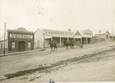
Photograph, 1910
Taken in 1910, this photograph depicts a scene of Bridge road in Newtown, Beechworth. Walking on the road are two men on horseback, one of which is pulling a carriage with a small dog standing beside it. Behind them are a line of small buildings and shops. Small industries began to expand dramatically in Beechworth, particularly during the 1860s, leading to a strengthening of the towns economy. As early as 1853, areas surrounding the waterway known as Spring Creek were surveyed with the intent of mapping out plans for new roads and building allotments. Land was sold and new buildings were erected, creating an expansion of the Beechworth township and retail services. One building shown in this photograph is Straughair and Duncan's Beechworth Foundry. This business was established in 1858 through the partnership of Mark Straughair and John Duncan. It dealt mostly in the manufacturing of castings and mining machinery, receiving orders from all over the Ovens district. The Business eventually collapsed after the deaths of Straughair in 1882 and Duncan in 1896 but was reopened by W.H. Phillips in 1905. The two other buildings are both associated with the name McKenzie. Evidence suggests that the McKenzie family has a long association with the town of Beechworth. This photograph is historically significant as it provides insight into the nineteenth and twentieth century industrial expansions that happened in the area of Newtown, leading to the urbanisation of Beechworth. Black and white rectangular photograph printed on matte photographic paper mounted on card.Reverse: Newton / 1997.2648 / 33 Newton Beechworth / 84-219-1 / McKenzies / BMM3055 / newtown beechworth, bridge road, 1910, j. duncan, r. mckenzie, m. straughair, industrial growth, ford street, beechworth foundry, straughair and duncan, mckenzie and sons grainstore, mckenzie family store -
The Beechworth Burke Museum
Audio - Oral History, Jennifer Williams, Mr Herbert McFeeters, 4 May 2000
Herbert McFeeters as born in Wooragee Creek in 11th July 1905. Mr McFeeters would walk to school in Beechworth by foot, about 3.5 miles through the hills. It would take him and his siblings one hour to get to school. Mr McFeeters worked at the local tannery from the age of 14 for 11 years. After which he worked for himself, farming cattle and selling milk around the region. Mr McFeeters bought land from the Crown, who were selling lands after many miners had left the region. Mr McFeeters recalls the Chinese community that remained the Beechworth area and the social activities in the town, including the pictures, football games and Harvest Festivals. This oral history recording was part of a project conducted by Jennifer Williams in the year 2000 to capture the everyday life and struggles in Beechworth during the twentieth century. This project involved recording seventy oral histories on cassette tapes of local Beechworth residents which were then published in a book titled: Listen to what they say: voices of twentieth century Beechworth. These cassette tapes were digitised in July 2021 with funds made available by the Friends of the Burke. Mr McFeeters oral history provides detail of life in rural Victoria during the early 20th Century. Mr McFeeters describes his early childhood and working life, including details of the social activities This oral history recording was part of a project conducted by Jennifer Williams in the year 2000 to capture the everyday life and struggles in Beechworth during the twentieth century. This project involved recording seventy oral histories on cassette tapes of local Beechworth residents which were then published in a book titled: Listen to what they say: voices of twentieth century Beechworth. These cassette tapes were digitised in July 2021 with funds made available by the Friends of the Burke. This is a digital copy of a recording that was originally captured on a cassette tape. The cassette tape is black with a horizontal white strip and is currently stored in a clear flat plastic rectangular container. It holds up 40 minutes of recordings on each side.Mr Herbert McFeeters /listen to what they say, beechworth, oral history, burke museum, herbert mcfeeters, wooragee creek, reid's creek -
 Eltham District Historical Society Inc
Photograph, Peter Pidgeon, White Cloud Cottage, 701 Main Road, Eltham, 2 Aug. 2022
Jarrold Cottage built c.1853, also known as 'White Cloud", located at 701 Main Road, Eltham, opposite Dalton Street. The house remains intact and is listed on the Victorian Heritage Database and considered historically significant to the Shire of Nillumbik. The cottage was originally located closer to the Diamond Creek but was subject to flooding. It was dragged by horse to the present site shown, which was chosen for the higher ground that had been created as a result of land fill being deposited here from the quarry further around the bend on Main Road (site of present-day Eltham Primary School carpark) where the stone had been quarried for building the State School in Dalton Street. It had previously been rented for use as a Police Station / residence prior to the building of the permanent police house and station at the corner of Maria and Brougham streets in 1859. The cottage was purchased by Lena Skipper after the death of Thekla Jarrold in 1943 and remains in the family to present day (2022). Part of a presentation by Peter Pidgeon to the Society, 13 August 2022 showcasing a series of photographs taken by John Henry Clark over the period 1895 to 1930.Born Digitaleltham, dalton street, main road, bootmaker's shop, jarrold cottage, white cloud cottage -
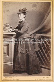 Eltham District Historical Society Inc
Photograph, Burman's Photographic Rooms, Possibly Jane Shillinglaw, c.1880
Jane Shillinglaw was born at Merri Creek, Victoria, June 14, 1846. She had a son, Joseph Shillinglaw (1863-1865) with an unknown partner. Joseph died as a toddler. She subsequently had a second child, a duaghter, Jane Davidson born 1870 She married William James Sommerville, ten years her junior at hawthorn on June 2, 1887. Jane died at Balwyn, Victoria on June 26, 1893. According to Sands & McDougall Melbourne Directory, Burman's were operating from 209 Bourke St. East and St George's Hall (73 Bourke St. East) from 1879-1885 CARTE-DE-VISITE (cdv) 1857-1890 Cartes-de-visite (cdv's) are the most common form of photograph from the nineteenth century, generally measuring two and a half inches by four and an eighth inches (6.3 x 10.5 cm) when mounted, sepia toned, mounted on a card which was generally printed with the photographer's name and address on the back or beneath the portrait. - Frost, Lenore; Dating Family Photos 1850-1920; Valiant Press Pty. Ltd., Berwick, Victoria 1991marg ball collection, shillinglaw family photo album 1, 1879-1885, 1880, burman's photographer 209 bourke st east and st georges hall melbourne, jane sommerville (nee shillinglaw 1846-1893), unknown -
 Eltham District Historical Society Inc
Photograph, Belle Vue, Livingstone Road, Eltham, c.1960, 1960c
Photo taken at time of ownership by Eric Staff. Originally purchased by pioneer Eltham farmer Henry Stooke, Belle Vue farm comprised about 56 ha (140 acres) extending northerly from the northern boundary of Holloway’s 1851 Little Eltham subdivision. On the present day map the southern boundary was just north of Elsa Court and Grove Street. The western boundary was the Diamond Creek and extended northerly to Main Road where it turns easterly towards Research. It was traversed by the main road to Kangaroo Ground and beyond and from 1912 by the railway to Hurstbridge. From 1895 the farm was owned by William Williams and his wife Mary Ann. In 1914-1915 they built a new house now known as “Belle Vue”. They sold the land in 1920 and residential subdivision began soon after that. “Belle Vue” remains today on a large residential lot in Livingstone Road. The house and many old trees on the site have been subject to a heritage overlay under the Nillumbik Planning Scheme. Despite that overlay, most of the heritage trees were removed during sub-division and development of the property.Digital file only from scan of copy on loan to EDHSbelle vue, eltham, eric staff, houses, livingstone road, staff family -
 Eltham District Historical Society Inc
Folder, Shire of Eltham Living and Learning Centre, 1996
Contents: 1. Hand drawn schematic record of site buildings as of 1975 compiled by Harry Gilham, Shire of Eltham Historical Society 2. History compiled on the ocassion of the Eltham Living and Learning Centre's 21st birthday in 1996. Includes historical notes about the property, origins of the Living and Learning Centre at Eltham which started in 1975. List of associate groups, friends of the creek, friends of the centre, playhouse, list of co-ordinators 3. Enrolment Day Cake recipe 4. Poem - "Who'd be a co-ordinator" by unknown 5. Traditions and Memories by Margaret Johnson, Program Co-ordinator for 10 years 6. Reminiscences by Linda Kirkwright, Admin Assistant 7. In the beginning there was a small cottage ... by Joanne Osborne, Assistant Co-ordinator 1977-1980 8. Newsclippings - Living and Learning Centre in Council Centre, Diamond Valley New, 2 Apr 1975; 'Rub-A-Dub" unknown publication; and miscellaneous advertisements 9. Copy of certifcate of title when transferred to the Shire of Eltham in 1975 10. Copy of 1992 Shire of Eltham Heritage Study, pages 930-936 with notations 48 A4 pages photocopies HG Booklets 22 and 47, 64eltham living and learning centre, enrolment day cake, harry gilham collection, heritage study, history, joanne osborne, linda kirkwright, margaret johnson, poem, recipe, reminiscences, who'd be a co-ordinator -
 Eltham District Historical Society Inc
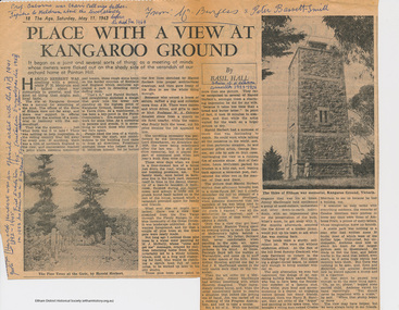
Folder, Basil Hall, 1999
Original newspaper article from "The Age" May 11, 1963. Place with a view at Kangaroo Ground by Basil Hall about the construction of the War memorial. The Hall family resided at "Fairview" Panton Hill in the 1920s. Hall was a Eltham Shire Councilor in the 1920s and was associated with the Eltham Shire war Memorial Tower Bulding Committee from 1924 to 1926. Photocopies from "The Road to Gundagi" by Graham McInnes (Hamish Hamilton, 1965), Chapter 9 pages 132 - 153 an autobiography in which the author reminiscences about visiting the Hall family at "Fairview" in Panton Hill as a child. References also to Watson's Creek where MacPherson Robertson ("The Chocolate King") had a summer home, the Shannons, Shanhun and McLaughlin familes. Includes description of the day that Hurstbridge was declared a township (May 26th, 1924), a ralway journey, picnics and rabbiting. McInnes' reminiscences about the periods of his childhood spent visiitng the Hall family in Panton Hill in the 1920s are a rare first hand glimpse into the recreational, social and municipal life in the 1920s within the this rural area within the Shire of Eltham. "Road to Gundagi" was the first of three widely acclaimed autobiographies.Original newspaper article Photocopies, 12 pages.HG Booklet 36basil hall, click here to add keywords, cr. basil hall, eltham war memorial, graham mcinnes, harry gilham collection, hurstbridge, kangaroo ground tower building committee, macpherson robertson, mclaughlin family, panton hill, picnicing, rabbiting, reminiscences, shanhun family, shannon family, shire of eltham war memorial, war memorial tower, watson's creek -
 Kiewa Valley Historical Society
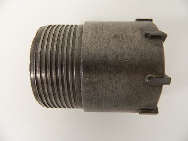
Drill Bit Diamond, circa mid to late 1900's
This hollow core bit has hard cutting inserts for drilling into rock. It was used to drill and recover 50mm diameter (most common size) rock cores. The rock cores were assessed by geologists and engineers to provide information for design of structures such as tunnels, dams and underground power stations (eg. McKay Creek Power Station, West Kiewa Power Station). This type of bit was also used where damage to the surrounding rock had to be minimised. The Diamond Drill Bit,used in the early 1900's, when it was primarily used as a method of sampling rock for ore deposits and oil exploration resulting in a "coring" of rock. The use of "coring" to obtained samples for the SEC Kiewa Hydro Electricity Scheme(1920's onward) was to analyse the core to obtain temperature and rainfall patterns shown by the levels of layered solidified soil(rock). This diamond drill would have been used in the early 1900's to provide a sub strata map of temperature and water patterns (over an long period of time). This was a pre requisite to any decisions about the viability of the region to provide the water needed for a successful hydro electricity scheme.This diamond drill for core sampling was at the forefront of the analysis whether to construct a hydro electrical facility in the Kiewa Valley and the adjoining alpine region. The rock core samples produced were assessed by geologists and structural engineers. It was only after extensive core drilling covering the region that solid scientific evidence could be provided to start the "SEC Vic Hydro Electricity Scheme" within its current boundaries.This "diamond" drill bit has eight "teeth" at its cutting edge. The drill creates an 55mm hole in extremely hard rock material to obtain 50mm core samples.. Three quarters down the shank it has thread screw channels to attach the bit to the drill pipe. The coring pipe attaches via screwing it onto this bit. Core samples are the main objective of this tool.alternate energy supplies, alpine feasibility studies temperature, rainfall, sec, kiewa hydro electric scheme, electricity -
 Eltham District Historical Society Inc
Photograph, Shire of Nillumbik World War One Memorials tour, 10 August 2016, 10 August 2016
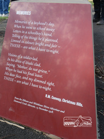
Memories Memories of a boyhood's day. When he went to scahool away Letters in a schoolboy's hand. telling of the things he's planned, Linned in colours bright and fair - THESE - are what I have to-night. Visions of a soldier-led, In his dress of khaki clad, Saying, "Mohter, do not grieve." When he has his final leave. His dear face, and my dimmed signt THESE - are what I have to-night. R.M. Conway, Christmas Hills From the Eltham and Whittlesea Shire Advertiser and Diamond Creek Advocate, 13 December 1918. As part of a program to acknowledge the Anzac Centenary Nillumbik Shire Council partnered with Yarra Plenty Regional Library to provide a bus tour with commentary of local sites of significance. These included Eltham township, the Shire of Eltham War Memorial at Kangaroo Ground, Christmas Hills, Hurstbridge memorial recreation park and finished at Eltham Library to view the Writing the War exhibtion at Eltham Library Community Gallery. In May 2015 Nillumbik Shire Council received Anzac centenary Local Grants Program funding for the restoration and enhancement of Christmas Hills cenotaph as a project to commemorate the First World War. Born Digitalworld war 1, war memorials, shire of nillumbik, christmas hills, interpretative signage, poem, "r.m. conway" -
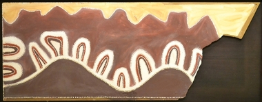 Burrinja Cultural Centre
Aboriginal painting - Paddy Jampin Jaminji, Paddy Jaminji, The Hills of Bedford Station, pre 1995
In around 1924 a band of Gija people crossed fences onto their traditional land near Bedford Downs Station in the East Kimberley 2000 km northeast of Perth and killed nine head of cattle. This act precipitated one of the massacres to become known as the 'killing times'. Paddy Quilty, the station owner of Bedford Downs had his men collect wagon loads of firewood which was distributed around the camp. He then invited everyone to assemble for their rations. The food, laced with strychnine, was handed out. As the Gija people fell down dying in agony, they were shot. The firewood was used to burn the bodies. One boy escaped to the the story. Paddy Jamin Jaminji (c.1922-1997) painted The Hills of Bedford Downs Station as part of a series of painting about the Killing Times. It depicts the story and sites of the massacre. At least twelve killing sites are recorded within a radius of 150 km of Turkey Creek, WA. The painting was possibly discarded due to its damage in one corner and later collected from an old shelter at Warmun on a field trip by collector Neil McLeod in 1995.Large painting on board of symbolic landscape. Brown, yellow, cream and white. Framed.bedford downs station, massacre, killing, gija, paddy quilty, turkey creek, warmun -
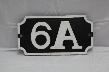 Puffing Billy Railway
Number Plate - 6A, 2010
Replica of a Victorian Railways replacement number board that 6A carried in the later 40's and 50's. This plate was created for the preservation society's reenactment trains in 2012 for the 50 year celebration of reopening to Menzies Creek. Loco: 6A In service Thursday, 18th July 1901 Livery Green Owner Puffing Billy Gauge 762 Status Preserved - Operational 6A Built in 1901 and painted two-tone green, this locomotive was issued to the Colac to Beech Forest line and was used in that line’s construction. Over the years, it saw service on all four lines, but mostly on the Colac to Crowes and Upper Fern Tree Gully to Gembrook lines. It was temporarily withdrawn from service in 1958 and returned to service at Belgrave in 1962 for the reopening of this line where it saw almost continuous service until being withdrawn in 1983. It has been restored, as far as possible, to its original condition with original design side tanks, low bunker, original size windows, etc., but a steel cow-catcher in place of the original style wooden one. It also has its original colour scheme of two-tone green with white lining.Historic - Replica Victorian Railways Locomotive Number Plate of the type used on Steam Locomotive 6A in the later 40's and 50's created for the preservation society's reenactment trains in 2012 for the 50 year celebration of reopening to Menzies Creek. Number Plate 6A Cast aluminum replica number board.6Apuffing billy, menzies creek, 6a, number plate -
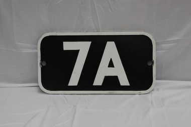 Puffing Billy Railway
7A Number Plate
Replica of a Victorian Railways replacement number board that 7A carried in the later 40's and 50's. This plate was created for the preservation society's reenactment trains in 2012 for the 50 year celebration of reopening to Menzies Creek. Loco: 7A In service Saturday, 6th May 1905 Livery Maroon Owner Puffing Billy Gauge 762 Status Preserved - Operational 7A Built in 1905 and painted Canadian red & dark brown, this locomotive was issued to the Wangaratta to Whitfield line and saw service on all four lines with most of its service on the Upper Fern Tree Gully to Gembrook line. It was temporarily withdrawn from service in 1958 and returned to service at Belgrave in 1962 for the reopening of this line where it has seen almost continuous service since. 1979 saw the early two-tone green colour scheme applied to this loco as a trial even though it never historically carried it, but its physical configuration was not altered accordingly. It is now painted its original livery of Canadian red & dark brown and will eventually be returned, as far a possible, to its original condition with a low bunker, narrow ash-chute, etc.Historic - Replica Victorian Railways Locomotive Number Plate of the type used on Steam Locomotive 7A in the later 40's and 50's created for the preservation society's reenactment trains in 2012 for the 50 year celebration of reopening to Menzies Creek Number Plate 7A Rectangular black and white number plate. Cast aluminum replica number board.7Apuffing billy, 7a, number plate