Showing 23419 items
matching emu-creek
-
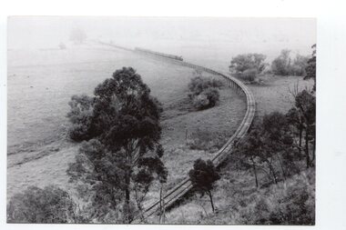
 Puffing Billy Railway
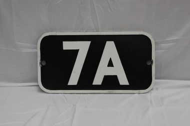
7A Number Plate
Replica of a Victorian Railways replacement number board that 7A carried in the later 40's and 50's. This plate was created for the preservation society's reenactment trains in 2012 for the 50 year celebration of reopening to Menzies Creek. Loco: 7A In service Saturday, 6th May 1905 Livery Maroon Owner Puffing Billy Gauge 762 Status Preserved - Operational 7A Built in 1905 and painted Canadian red & dark brown, this locomotive was issued to the Wangaratta to Whitfield line and saw service on all four lines with most of its service on the Upper Fern Tree Gully to Gembrook line. It was temporarily withdrawn from service in 1958 and returned to service at Belgrave in 1962 for the reopening of this line where it has seen almost continuous service since. 1979 saw the early two-tone green colour scheme applied to this loco as a trial even though it never historically carried it, but its physical configuration was not altered accordingly. It is now painted its original livery of Canadian red & dark brown and will eventually be returned, as far a possible, to its original condition with a low bunker, narrow ash-chute, etc.Historic - Replica Victorian Railways Locomotive Number Plate of the type used on Steam Locomotive 7A in the later 40's and 50's created for the preservation society's reenactment trains in 2012 for the 50 year celebration of reopening to Menzies Creek Number Plate 7A Rectangular black and white number plate. Cast aluminum replica number board.7Apuffing billy, 7a, number plate -
 Nillumbik Shire Council
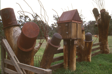
Sculpture: Tony Trembath (b.1946 Sale, Victoria), Tony Trembath, The Fences Act 1968 - Location: Edendale Farm (entrance) 30 Gastons Road, Eltham, 1989 - 1994
Eltham Council (now the Shire of Nillumbik) commissioned this work in 1989 to create an entrance / gateway to Edendale Community Farm. It was also aided by a grant from the Ministry of the Arts (now Arts Victoria). The former name of this work was "Gateway to Edendale Farm". Edendale Farm is a demonstration farm modelling sustainable environmental practices, providing support to the local residents of Nillumbik. Established in 1986, the land was purchased in 1970. It was previously an English gentleman's residence and was used for grazing. It consists of 5.6 hectares, with the Diamond Creek meandering through the property. The Victorian Fences Act 1968 governs liability of occupiers of adjoining lands to fence, and deals with disputes between neighbours regarding boundaries fences and costs. This work took into consideration ideas and suggestions from residents and committees, who required the use of recycled materials and that the work celebrate man's relationship with nature, animals and the earth, as well as relate to the fence-line on the far side of the carpark. Trembath also absorbed significant aspects of local history, making references to Eltham's agricultural past, the clearing of the land, the destruction of trees, the ruthless pruning of trees by suburban Councils and incorporated such Australian features as the post and rail fence. 'The Fences Act 1968' is significant for aesthetic, historic and social reasons at a regional level. It makes prominent the historical and social significance of Edendale and the rural aspects of Nillumbik. The use of existing tree stumps and salt pots in the work explores the iconography of the countryside such as the isolated farmhouse, pioneering farming practices, post and rail fencing and the regrowth of lopped trees. The title of the work, as well as the extensive community involvement in its creation, also makes reference to the Victorian Fences Act 1968, which makes neighbours jointly responsible for the cost of construction and maintenance of fences in the partitioning of land for settlement. 'The Fences Act 1968' has been classified as of regional significance by the National Trust of Australia. The work is an installation of wood and metal, approximately twenty five meters long. The design is very informal and rustic and runs the full width of the fence-line. It comprises groups of recycled tree trunks fitted with metal caps (chrome-nickel 'salt pots' that are shaped like tall bowler / top hats). Metal rods protrude from the trunks and some of these rods have metal birds. Two larger, sentinel-like stumps at the two outer ends have metal flame-like wings, which bend inward. To the left of the entrance, a simple architectural element indicates an isolated farmhouse. The rustic fence runs between the groups of tree trunks with native planting in clumps along it. The fence-line incorporates a functional engineered double gate and post and rail fencing. There may be many interpretations of the work and the intention is to stimulate interest and imagination rather than alienate. Interpretation is based on the personal experience that a visitor brings. The artist recommended that no explanation of the design logic be positioned with the work. N/Apublic art, sculpture, edendale, recycled, wood, metal, fences act 1968, gate, trembath, salt pot, tree stumps -
 Vision Australia
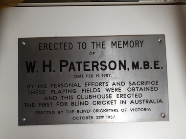
Photograph - Image, W.H. Paterson - Blind Cricketers of Australia, 1957
When the Victorian Blind Cricket Association approached Mr Paterson for assistance in gaining access to a permanent cricket pitch upon which games could be played, it set in chain a series of events that remain in place today. Mr Paterson had been heavily involved in the formation of the Association for the Blind and saw this as a problem to be solved. Raising money through public donation and door knocking, Mr Paterson arranged the purchase of land on the banks of Gardiner's Creek, and adjacent to the tram and train lines. The land was raised, to avoid flooding, and a surface prepared. The sportsground was adjacent to the AAB, however due to the interest of Malvern Council in the land and knowing that the AAB at that time was in financial difficulties, a Trust was set up to handle the management with Mr Paterson, Mr Gould the Malvern Council Town Clerk and George Maxwell as trustees. A clubhouse was also needed to allow players to take shelter during matches and once again, Mr Paterson came to the rescue. Using their personal funds, Mr and Mrs Paterson loaned the Trust the monies required for the building. This plaque recognises the dedication and support that Mr Paterson gave to help establish the first blind cricket playing ground in Australia.Digital image of metal plaqueErected to the Memory of W.H. Paterson, M.B.E. Obit. Feb. 19 1957 By his personal efforts and sacrifice these playing fields were obtained and this clubhouse erected The first for blind cricket in Australia Erected by the Blind Cricketers of Victoria October 22nd 1957william paterson, victorian blind cricket association -
 Falls Creek Historical Society
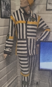
Uniform - Olympic Games Ski Suit 1976
Winter Olympics, Innsbruck, Austria. This uniform was donated to the Falls Creek Historical Society by Dr. Howard W. Farrow who was appointed as a Medical Officer for the Australian Olympic Games Team of 1976. Dr. Farrow's father, Dr. Claude Farrow was a founding member of the Edelweiss Ski Club of Australia which was formed in 1947. He was also the Founding President of the Federation of Victorian Ski Clubs (F.O.V.S.C) which produced the Ski-Horizon journal. Dr. Howard Farrow reported that "the Europeans laughed at us and called us the prisoners". Australia sent a team of eight athletes to Innsbruck, five men and three women. The team consisted of alpine skiers Kim Clifford, David Griff, Robert McIntyre, Joanne Henke and Sally Rodd; figure skaters Billy Schober and Sharon Burley and speed skater Colin Coates, who was competing in his third Winter Olympics. This uniform was designed by famous fashion designer Pru Acton OAM, in response to a request by athletes for a more colourful uniform than the standard green blazer previously worn by the Australian team at the Opening and Closing Ceremonies of the Games.This uniform is significant because it was a modern development of Australian Winter Olympic team uniforms created by a famous Australian fashion designer.The Australian Ski Suit for the 1976 Winter Olympic Games. It has patches of big bold black and white stripes, set horizontally and vertically, with panels of yellow. The Australian emblem of Olympic circles and a kangaroo are placed on the back and front of the jacket and on the arm and leg. A bib-and-brace overall in matching stripes was worn under the jacket.1976 winter olympics, australian winter olympics uniforms, pru acton, dr. howard farrow -
 City of Greater Geelong
Painting - Acrylic on Canvas, Billy-Jay O'Toole, Wadawurrung Country and Connection, 2019
The blue section of the paining represents our amazing ocean, bays, rivers, creeks and wetlands. The white creamy section represents our coastline with the footprints imbedded into the sand tells the story of our old people who have been so connected to this coastline for many thousands of years, the mountain represents the You Yangs which holds a special part of our history here on Wadawurrung country, the 7 gathering circles in the mountain represents the 7 family groups within Wadawurrung, WAA the crow he is our protector here on country and Bundjil is our creator which is why I have implemented these 2 birds into my painting, the u shape people symbols represents my family of 5 generations still living on Wadawurrung country, my great grandmother Joye Eccles my pop norm Eccles my mum Corrina Eccles myself and my beautiful daughter Alira, the eucalyptus leaves up the top is a part of cleansing I have incorporated therese leaves because this country is cleansed everyday by he family when conducting a smoking ceremony.Painting of Eagle and Crow with water and footprints below. Brown, orange, blue, green, black used.bundjil, you yangs, wadawurrung -
 Melton City Libraries
Newspaper, James Pinkerton, 1991
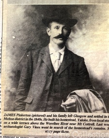
"James Pinkerton, described by fellow settler Isaac Batey as ‘a fine old Scotish [sic] gentleman’, and his wife Margaret established ‘Chamois Ponds’ on Kororoit Creek in the Keilor district in 1840.44 After a fire in 1848, the Pinkerton family moved further west to a holding called Yaloke, on the Werribee River in the Melton district.45 Today, the Surbiton Park water treatment plant operates on part of the Yaloke run. The Pinkerton family is remembered in Melton in part due to the historic graves of the original settler, Margaret Pinkerton, and four of her grandchildren, which were marked by a memorial cairn in 1931. Changes to sewage flood zoning in the area in the 1990s necessitated that these burials be relocated. Members of the Melton & District Historical Society oversaw a project to relocate the Pinkerton graves and cairn 200 metres from their original site to their current resting place at Mount Cottrell. This relocation ceremony took place on 8 November 1992, with the participation of local school students and with Pinkerton descendants playing a central role. This occasion also marked the opening of the Pinkerton Forest Project, which saw 50 hectares of degraded woodland in Surbiton Park protected for regeneration".Photograph of Jame Pinkerton featured in the the Telegraphlocal identities, pioneer families -
 Falls Creek Historical Society
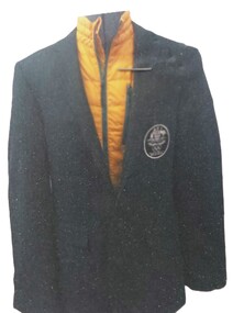
Clothing - Britteny Cox - Blazer Sochi WInter Olympics
Britteny (Britt) Cox was born in Wodonga, Victoria in 1994. She grew up skiing alpine and mogul events on the slopes of Falls Creek. In 2004 she competed in her first International Ski Federation (FIS) event at Mt. Buller. At Vancouver 2010, 15-year-old Britt made history as the youngest Australian to compete at a Winter Olympic Games. She went on to compete at Sochi 2014, PyeongChang 2018 and Beijing 2022, despite breaking six ribs and a collarbone in a crash in 2019. In 2012, she was awarded an Australia Sport Hall of Fame scholarship. Her major breakthrough came in 2016/17 season when she took seven victories and two third place finishes to win the moguls as well as the overall freestyle World Cup titles, thus becoming the first Australian woman to win the Crystal Globe in moguls. She finished off a highly successful campaign by winning the World Championship title in Sierra Nevada. After 12 years of competing on the highest level at the FIS Freestyle Skiing World Cup tour, Britteny announced her retirement from competitive skiing in July 2022.This blazer is significant because it was worn by Falls Creek Skier Britteny Cox at the Winter Olympics Sochi 2014.Opening Ceremony blazer for the Winter Olympics Sochi, 2014. It is a bottle green blazer lined with the names of the 198 Australian winter Olympians.britteny cox, australian winter olympians, mogul skier, sochi olympics 2014 -
 Melbourne Legacy
Medal, Australian Service Medal and Pacific Star Medal, 1949
The Australian Service Medal and Pacific Star Medal that were awarded to Private Arthur Norman Comben VX26251 for his war service in World War Two. From the AWM website Private Arthur N Comden of the 2/21st Australian Infantry Battalion, who died on Hainan Island, China, on 27 June 1945. The DVA records show he was born 6 April 1907 in Yarraville and enlisted on 17 June 1940 whilst residing in Coopers Creek Victoria. His next of kin was shown as H Dilks. Also that he had been a prisoner of war. His connection with Legacy is not known, he may have been a junior legatee though there's no record of his father Arthur John Louis Comben serving for Australia in WW1. More research is needed to check, it is possible the medals were donated to Legacy as no family members wanted them. Additional information provided by a distant relative - Arthur's mother (Mary Eleanor Norman) remarried twice after his fathers death in 1911. His stepfather Horace Dilks served in World War 1 with the 2nd Pioneer Battalion.These are examples of World War 2 medals awarded to a serviceman who participated in the conflict in the Pacific region. Many returned servicemen joined Legacy after World War 2 and would have had similar medals.Silver circular medal and bronze star shaped medal from World War 2 mounted on ribbons initially together by a safety pin. 01700.1 The medal is nickel silver with the crowned effigy of King George VI on the obverse. The reverse has the Australian coat of arms, placed centrally, surrounded by the words ‘THE AUSTRALIA SERVICE MEDAL 1939-1945’. The normal ribbon is missing and it is on the ribbon meant for the UK War Medal which is of red, white and blue to represent the colours of the Union Flag. 01700.2 The six–pointed star is yellow copper zinc alloy. The obverse has a central design of the Royal and Imperial cypher, surmounted by a crown. The cypher is surrounded by a circlet containing the words ‘The Pacific Star’. The ribbon has central yellow and green stripes that represent the forests and the beaches of the Pacific, flanked dark blue, light blue and red stripes that represent the service of the Naval Forces and Merchant Navy, the Air Forces and the Armies.Both engraved with 'VX26251 A. N. Comben'.medals, world war two, arthur comden -
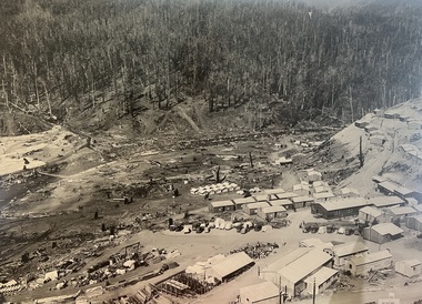
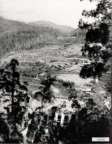
 Falls Creek Historical Society
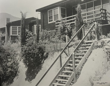
Photograph - Bogong Alpine Village Houses 1946
The images in the Bogong Village Collection were displayed in Bogong Jack’s Tavern for over 20 years and were donated to the Falls Creek Museum when the Tavern closed in 2021. In 1939, the State Electricity Commission of Victoria established a field headquarters at Bogong to house workers and their families for the Kiewa Hydroelectric Scheme which ran from the 1930s to the 1960s. The workmen's camp was originally started with tents and was called Junction Camp. By 1947, the village supported 300 workers and their families. It included 40 houses, a hostel for single staff, a post office, a police station, a medical centre, and a primary school. The staff hostel was known as Kiewa House. At the completion of the Scheme, in the 1960s, the village was opened to public/tourism use. In 1968 the Victorian Education Department acquired the camp buildings and four houses from the State Electricity Commission of Victoria to establish an Outdoor Education Centre which operated for over 50 years. The Kiewa Hydroelectric Scheme was privatized in the 1990s and sold to Southern Hydro, before being acquired by AGL in 2005. In 2023 the Grollo Group signed a 73 year sublease on Bogong Village and has plans for its redevelopment as a workers’ village.These images are significant because they capture the development of Bogong Village as an important element of the Kiewa Hydroelectric Scheme in Victoria.Two black and white images featuring houses in Bogong Village in January 1946. They are constructed of weatherboard, with brick chimneys and tin roofs. Timber steps lead up to the front door and a garden has been planted in front of the house.bogong alpine village, bogong high plains, bogong houses 1946 -
 Falls Creek Historical Society
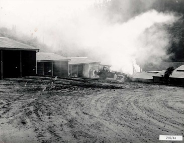
Photograph - Bogong Alpine Village 1944
The images in the Bogong Village Collection were displayed in Bogong Jack’s Tavern for over 20 years and were donated to the Falls Creek Museum when the Tavern closed in 2021. In 1939, the State Electricity Commission of Victoria established a field headquarters at Bogong to house workers and their families for the Kiewa Hydroelectric Scheme which ran from the 1930s to the 1960s. The workmen's camp was originally started with tents and was called Junction Camp. By 1947, the village supported 300 workers and their families. It included 40 houses, a hostel for single staff, a post office, a police station, a medical centre, and a primary school. The staff hostel was known as Kiewa House. At the completion of the Scheme, in the 1960s, the village was opened to public/tourism use. In 1968 the Victorian Education Department acquired the camp buildings and four houses from the State Electricity Commission of Victoria to establish an Outdoor Education Centre which operated for over 50 years. The Kiewa Hydroelectric Scheme was privatized in the 1990s and sold to Southern Hydro, before being acquired by AGL in 2005. In 2023 the Grollo Group signed a 73 year sublease on Bogong Village and has plans for its redevelopment as a workers’ village.These images are significant because they capture the development of Bogong Village as an important element of the Kiewa Hydroelectric Scheme in Victoria.A collection of four black and white images capturing the weather conditions in the Bogong area in June 1944bogong alpine village, bogong high plains, bogong june 1944 -
 Falls Creek Historical Society
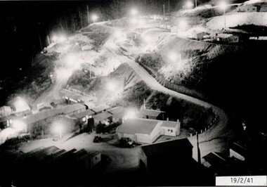
Photograph - Bogong Alpine Village 1947
The images in the Bogong Village Collection were displayed in Bogong Jack’s Tavern for over 20 years and were donated to the Falls Creek Museum when the Tavern closed in 2021. In 1939, the State Electricity Commission of Victoria established a field headquarters at Bogong to house workers and their families for the Kiewa Hydroelectric Scheme which ran from the 1930s to the 1960s. The workmen's camp was originally started with tents and was called Junction Camp. By 1947, the village supported 300 workers and their families. It included 40 houses, a hostel for single staff, a post office, a police station, a medical centre, and a primary school. The staff hostel was known as Kiewa House. At the completion of the Scheme, in the 1960s, the village was opened to public/tourism use. In 1968 the Victorian Education Department acquired the camp buildings and four houses from the State Electricity Commission of Victoria to establish an Outdoor Education Centre which operated for over 50 years. The Kiewa Hydroelectric Scheme was privatized in the 1990s and sold to Southern Hydro, before being acquired by AGL in 2005. In 2023 the Grollo Group signed a 73 year sublease on Bogong Village and has plans for its redevelopment as a workers’ village.These images are significant because they capture the development of Bogong Village as an important element of the Kiewa Hydroelectric Scheme in Victoria.Two black and white images capturing Bogong Village by night and the spillway at Junction Dam.bogong alpine village, bogong high plains, bogong 1947 -
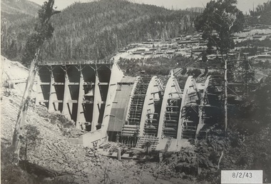
 Falls Creek Historical Society
Photograph - Bogong Alpine Village and Howman's Dam Camp 1948
The images in the Bogong Village Collection were displayed in Bogong Jack’s Tavern for over 20 years and were donated to the Falls Creek Museum when the Tavern closed in 2021. In 1939, the State Electricity Commission of Victoria established a field headquarters at Bogong to house workers and their families for the Kiewa Hydroelectric Scheme which ran from the 1930s to the 1960s. The workmen's camp was originally started with tents and was called Junction Camp. By 1947, the village supported 300 workers and their families. It included 40 houses, a hostel for single staff, a post office, a police station, a medical centre, and a primary school. The staff hostel was known as Kiewa House. At the completion of the Scheme, in the 1960s, the village was opened to public/tourism use. In 1968 the Victorian Education Department acquired the camp buildings and four houses from the State Electricity Commission of Victoria to establish an Outdoor Education Centre which operated for over 50 years. The Kiewa Hydroelectric Scheme was privatized in the 1990s and sold to Southern Hydro, before being acquired by AGL in 2005. In 2023 the Grollo Group signed a 73 year sublease on Bogong Village and has plans for its redevelopment as a workers’ village.These images are significant because they capture the development of Bogong Village as an important element of the Kiewa Hydroelectric Scheme in Victoria.Two images capturing the depiction Bogong Village and the Howman's Dam Camp 1948bogong alpine village, bogong high plains, bogong 1947 -
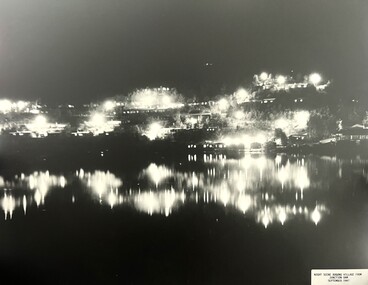
 Falls Creek Historical Society
Photograph - Aerial View of Bogong Alpine Village
The images in the Bogong Village Collection were displayed in Bogong Jack’s Tavern for over 20 years and were donated to the Falls Creek Museum when the Tavern closed in 2021. In 1939, the State Electricity Commission of Victoria established a field headquarters at Bogong to house workers and their families for the Kiewa Hydroelectric Scheme which ran from the 1930s to the 1960s. The workmen's camp was originally started with tents and was called Junction Camp. By 1947, the village supported 300 workers and their families. It included 40 houses, a hostel for single staff, a post office, a police station, a medical centre, and a primary school. The staff hostel was known as Kiewa House. At the completion of the Scheme, in the 1960s, the village was opened to public/tourism use. In 1968 the Victorian Education Department acquired the camp buildings and four houses from the State Electricity Commission of Victoria to establish an Outdoor Education Centre which operated for over 50 years. The Kiewa Hydroelectric Scheme was privatized in the 1990s and sold to Southern Hydro, before being acquired by AGL in 2005. In 2023 the Grollo Group signed a 73 year sublease on Bogong Village and has plans for its redevelopment as a workers’ village.These images are significant because they capture the development of Bogong Village as an important element of the Kiewa Hydroelectric Scheme in Victoria.An aerial view of Bogong Village and surrounds, date unknown.bogong alpine village, bogong high plains, aerial photos bogong village -
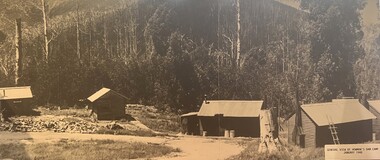
 Falls Creek Historical Society
Photograph - Bogong Alpine Village 1943
The images in the Bogong Village Collection were displayed in Bogong Jack’s Tavern for over 20 years and were donated to the Falls Creek Museum when the Tavern closed in 2021. In 1939, the State Electricity Commission of Victoria established a field headquarters at Bogong to house workers and their families for the Kiewa Hydroelectric Scheme which ran from the 1930s to the 1960s. The workmen's camp was originally started with tents and was called Junction Camp. By 1947, the village supported 300 workers and their families. It included 40 houses, a hostel for single staff, a post office, a police station, a medical centre, and a primary school. The staff hostel was known as Kiewa House. At the completion of the Scheme, in the 1960s, the village was opened to public/tourism use. In 1968 the Victorian Education Department acquired the camp buildings and four houses from the State Electricity Commission of Victoria to establish an Outdoor Education Centre which operated for over 50 years. The Kiewa Hydroelectric Scheme was privatized in the 1990s and sold to Southern Hydro, before being acquired by AGL in 2005. In 2023 the Grollo Group signed a 73 year sublease on Bogong Village and has plans for its redevelopment as a workers’ village.These images are significant because they capture the development of Bogong Village as an important element of the Kiewa Hydroelectric Scheme in Victoria.A collection of seven black and white images capturing the development of Bogong Alpine Village and the Pretty Valley area during 1943.bogong alpine village, bogong high plains, bogong 1943 -
 Falls Creek Historical Society
Photograph - Bogong Alpine Village 1942
The images in the Bogong Village Collection were displayed in Bogong Jack’s Tavern for over 20 years and were donated to the Falls Creek Museum when the Tavern closed in 2021. In 1939, the State Electricity Commission of Victoria established a field headquarters at Bogong to house workers and their families for the Kiewa Hydroelectric Scheme which ran from the 1930s to the 1960s. The workmen's camp was originally started with tents and was called Junction Camp. By 1947, the village supported 300 workers and their families. It included 40 houses, a hostel for single staff, a post office, a police station, a medical centre, and a primary school. The staff hostel was known as Kiewa House. At the completion of the Scheme, in the 1960s, the village was opened to public/tourism use. In 1968 the Victorian Education Department acquired the camp buildings and four houses from the State Electricity Commission of Victoria to establish an Outdoor Education Centre which operated for over 50 years. The Kiewa Hydroelectric Scheme was privatized in the 1990s and sold to Southern Hydro, before being acquired by AGL in 2005. In 2023 the Grollo Group signed a 73 year sublease on Bogong Village and has plans for its redevelopment as a workers’ village.These images are significant because they capture the development of Bogong Village as an important element of the Kiewa Hydroelectric Scheme in Victoria.A collection of four black and white images capturing the development of Bogong Alpine Village and the Pretty Valley area during 1942.bogong alpine village, bogong high plains, bogong 1942 -
 Falls Creek Historical Society
Photograph - Bogong Alpine Village 1941
The images in the Bogong Village Collection were displayed in Bogong Jack’s Tavern for over 20 years and were donated to the Falls Creek Museum when the Tavern closed in 2021. In 1939, the State Electricity Commission of Victoria established a field headquarters at Bogong to house workers and their families for the Kiewa Hydroelectric Scheme which ran from the 1930s to the 1960s. The workmen's camp was originally started with tents and was called Junction Camp. By 1947, the village supported 300 workers and their families. It included 40 houses, a hostel for single staff, a post office, a police station, a medical centre, and a primary school. The staff hostel was known as Kiewa House. At the completion of the Scheme, in the 1960s, the village was opened to public/tourism use. In 1968 the Victorian Education Department acquired the camp buildings and four houses from the State Electricity Commission of Victoria to establish an Outdoor Education Centre which operated for over 50 years. The Kiewa Hydroelectric Scheme was privatized in the 1990s and sold to Southern Hydro, before being acquired by AGL in 2005. In 2023 the Grollo Group signed a 73 year sublease on Bogong Village and has plans for its redevelopment as a workers’ village.These images are significant because they capture the development of Bogong Village as an important element of the Kiewa Hydroelectric Scheme in Victoria.A collection of four black and white images capturing the development of Bogong Alpine Village. They depict development of the new village, the surrounding area and some staff members during 1941.bogong alpine village, bogong high plains, bogong 1941 -
 Eltham District Historical Society Inc
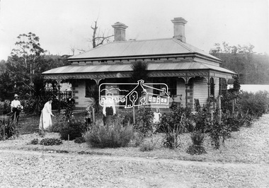
Negative - Photograph, Allwood, Hurstbridge, 1905
Allwood, Hurstbridge, 1905. Hurst/Gray family in the garden in front of the Victorian style Allwood house with lace iron work on the verandah. Left to Right: Whittaker, Mrs. Catherine Hurst, Frederick George Hurst (at rear), Hurst Gray, Mrs. Frances Ellen Gray (nee Hurst), William (Bill) George Gray, Sylvia Gray (later Birch). Frederick and Catherine Hurst relocated this Victorian style weatherboard home from an inner Melbourne suburb to its present site on their Allwood property. Mr Charles Verso, builder and farmer, reassembled and refurbished the home for the Hurst’s. In 1897 Frederick and Catherine’s daughter, Frances Ellen, married William (Bill) George Gray of Cottlesbridge and the newlyweds moved into the new house. Frederick and Catherine Hurst moved into a little cottage, ‘Mia Mia’, on the other side of the Diamond Creek. William and Frances Gray established Allwood Nursery and by 1900 most of the Allwood property was under orchard, largely apples, pears, cherry plums and peaches. They also developed an extensive nursery, growing seedling stock for supply to other local orchardists and the overseas market. Cross Ref: Sepp_1018 Source: Mrs. Ferguson, Hurstbridge This photo forms part of a collection of photographs gathered by the Shire of Eltham for their centenary project book,"Pioneers and Painters: 100 years of the Shire of Eltham" by Alan Marshall (1971). The collection of over 500 images is held in partnership between Eltham District Historical Society and Yarra Plenty Regional Library (Eltham Library) and is now formally known as The Shire of Eltham Pioneers Photograph Collection.' It is significant in being the first community sourced collection representing the places and people of the Shire's first one hundred years.Digital image 4 x 5 inch B&W Neg Print 20 x 25 cm (x2)shire of eltham pioneers photograph collection, hurstbridge, hurst family, sylvia gray, hurst gray, whittaker, allwood house, allwood, frederick george hurst, gray family, mrs. catherine hurst, mrs. frances ellen gray (nee hurst), william (bill) george gray -
 Eltham District Historical Society Inc
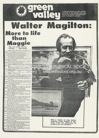
Document - Folder, Magilton, Walter
Walter Magilton left school early to become a dairy farmer in Western Victoria, returned to school and became a secondary school art teacher, eventually becoming an artist full-time, a painter, sculptor and jewellery maker. His paintings are in collections overseas and Australia. He teaches art from his Stony Creek Studio in Warrandyte and married to contemporary installation artist Denise Keele-bedford. Contents Newspaper article: "Walter Magilton: More to life than Maggie", Green Valley, section of Diamond Valley News, no date, details of Walter Magilton's career, his tame blackbird Maggie. Newspaper article: "Walter Magilton - Warrandyte", Network, October 1987, details of Walter Magilton's career, achievements and painting style. Newspaper article: "A modern twist on reality", Diamond Valley Leader, no date, Walter Magilton's exhibition at Bridges Restaurant, Hurstbridge. He collaborates with his wife Denise Keele-bedford, a contemporary installation artist. Newspaper article: "Walter Magilton: A Life's Journey in Art", Manningham and Nillumbik Bulletin, issue 51, July 2024. Walter Magilton to exhibit at Monsalvat.Newspaper clippings, A4 photocopies, etcwalter magilton, warrandyte victoria, stony creek studio warrandyte, denise keele-bedford, bridges restaurant hurstbridge, montsalvat, cowley's creek near camperdown, lou evans, carey grammar school, geelong teachers college, charles bush, lenton parr, william carey, mg car club, donvale christian college, alison magilton, warrandyte, bib silwell silverstone motors -
 Frankston RSL Sub Branch
Statuette, Mates
Small statuette depicting an Australian serviceman assisting a wounded comrade. The statuette depicts a scene from a famous moving film taken in New Guinea during World War 2 by Australian War Correspondent, Damien Peter Parer who was attached to the Australian Military Forces. The statuette is made from Pewter and is mounted on a stained wooden base. The following text statement is copied from the AWM website and describes the image in further detail: During the advance on Salamaua VX89711 Sergeant Gordon Raymond Charles Ayre MM, a 58/59th Battalion bandsman from Shepparton, Victoria, in pouring rain assists a wounded mate, VX132355 Private William Oswald Wallace Johnson, of the same unit, across Alan's (Allen's?) Creek to an advanced regimental aid post. Johnson had been wounded by a Japanese grenade on the 13th of July 1943 during an attack on the "coconuts" area. Sergeant Ayre was awarded the military medal for his performance during this action. This is one of the iconic images of the Second World War. (Still from AWM film F01866 "Assault on Salamaua", newsreel by Damien Parer)The wooden base has a label which is inscribed with the following: "MATES" Heritage Fine Arts, Limited Edition -
 Bendigo Historical Society Inc.
Document - ARTICLES FOR ROYAL HISTORICAL SOCIETY (BENDIGO BRANCH) NEWSLETTER APRIL 1973
Articles for Royal Historical Society (Bendigo Branch) Newsletter - April 1973. 1. From Bendigo Advertiser 15/10/1950 re Bendigo's first unofficial postman, Mr Collier, White Hills. 2.''Inaugurating the New Lock Up'' from Bendigo Advertiser 20/9/1861; mention of Detective Thompson and first inhabitant of Market Square lockup (man named Diamond). 3. Chinese Testimonial (Bendigo Advertiser 27/11/1856) re ring presented to Mr Lysaght as their ''first lawyer''. 4. Bendigo City Coat of Arms - description of this in detail and the representations of the Coat of Arms that are incorrect (eg on three sides of the City Hall) Suggestion - '' see the old Council Chambers'' for ''portraits'' of the (full and correct?) Bendigo Coat of Arms.5. Article from Bendigo Advertiser 4th Jan 1864 re storm of 31/1/1864 (sic) December? Mention of Axe Creek Bridge Hotel of Mr Costelloe. A note from 1973 from author that this hotel might later have been renamed 'The Perseverance' hotel; details of severed storm and flash flood of the day. [Two copies].document, names of bendigo pioneers, bendigo -
 The Beechworth Burke Museum
Photograph - Photograph - Reproduction, Unknown
This image is a reproduction of an 1899 original depicting the 'Williams Good Luck Mine' on the Mopoke Reef (also called 'Morepork Gully') in the Dingle Ranges, approximately three miles from Beechworth. The foreground of the image is littered with piles of smashed rock and detritus, known as ‘mullock’, beside a reinforced mine shaft, a vertical access passageway allowing miners to enter the mine and haul ore out using lifting technology such as a poppet heads, whims or windlasses. A group of miners and a dog appear close to an open-sided miner’s hut. Following the discovery of gold at Beechworth in 1852, rushes quickly followed at surrounding creeks and gullies in the district. In the late nineteenth and early twentieth centuries, small syndicates of miners continued to work old or abandoned quartz reefs, often persisting without the assistance of heavy machinery to remove the large amounts of rock, in order to obtain yields at ever greater depths. The group of miners in this photograph are Mr. Roger Williams and Sons, who revived operations at the ‘Old Good Luck’ mine on the Mopoke Reef in the Dingle Range near Beechworth around 1892, working the site for more than two decades. An emigrant from Cornwall with experience in the tin mining industry, 19 year old Roger Williams senior sailed to New Zealand in 1840, then to Australia where he spent time in the Bendigo Gold Fields before settling in Beechworth in the early 1860s. Mr Williams senior worked on various mining activities in the district, including the Rocky Mountain Tunnel project. Conversant with the character of gold-bearing reefs in the area, the syndicate dug an eight hundred foot tunnel, digging down as far down as two hundred feet with little capital save their labour, to connect and provide better working access to the mass of reefs and veins in the vicinity. Progress was hampered by poor air quality charged with fumes from dynamite and large quantities of rock had to be crushed to obtain payable yields. The Victorian Goldfields are filled with ruins and remnants of the area's rich mining history, ranging from small alluvial diggings to the remains of huge mining companies. Site names often changed several times throughout the nineteenth and twentieth centuries. Some sites were abandoned and forgotten, others were worked continuously over many decades. The names of mines were often repeated at different locations throughout the Victorian Goldfields. For example, there is a Mopoke Gully heritage mine near Fryers Creek, Victoria. 'Mopoke' is a common onomatopoeic name for Morepork and Australian Boobook owls. This image has historical, social and research significance for patterns of emigration during of the Victorian Gold Rush, and the historical, social and environmental impacts of mining at Beechworth at the turn of the nineteenth and twentieth centuries. As gold became scarce and government support and large company investment waned, poor hard-working miners laboured intensively to make a living through periods of high unemployment. This image can be compared and studied alongside other historical mining photographs and objects in the Burke Museum Collection. It has potential to improve our understanding of miners working conditions and the shifting character of mining in the Beechworth district. Black and white rectangular reproduction photograph printed on matte photographic paper.Obverse: Williams Good Luck Mine Beechworth / Roger! / Reverse: 6858 / burke museum, beechworth museum, beechworth, gold fields, gold rush, victorian gold rush, gold ming history, colonial australia, australian gold rushes, mining technology, beechworth historic district, indigo gold trail, migration, indigo shire, good luck gold mine, victorian goldfields, mining syndicates, gold fever, quartz-mining, small-scale mining, old good luck mine, mopoke gully, quartz reefs beechworth -
Eltham District Historical Society Inc
Document - Folder, Mann, John and Violet and family
John Mann arrived from Forfar, Scotland, on the clipper packet "Ellen Stuart" in 1857 and rented a farm "Overton" at Janefield. Soon after he met Melbourne-born Violet McKimmie, whose parents had a property near Darebin Creek. They married on 25 September 1862, John 26 and Violet 19. In 1874 John selected a block on Arthurs Creek and built a slab and bark hut (still standing in 1984) and called their farm "Carseburn" after John's parish in Scotland. They had seven children: John, Jane, Christine, David, Walter, James and Violet. John was drowned in the Yarra in May 1875 and Violet struggled to meet the lease commitment. She wrote to her brother-in-law David Mann in New Zealand who came to her aid, and on 10 September 1876, they married at the Victorian Free church, Smith Street, Collingwood. They improved the farm and built a three-room house. in July 1883 they bought neighbouring land from Ann Welsh. With David, Violet had four more children: Robert, William and twins Thomas and Henry. In 1883, David died and was buried in the same grave as his brother in Preston Cemetery. The twins also died, Thomas just before and Henry just after their father. the children assisted with the farm and orchard, the business including crops, a dairy herd, Carseburne sheep, and breeding horses. Violet died at Yan Yean in 1925, aged 83. A grandson of John Mann, James Mann, lived in Henry Street, Greensborough and had given a talk at the Whittlesea Historical Society in 1983 on his family. Descendant Lindsay Mann was part of a creative writing group that published a book including a short story "The Mountain Tramway" is loosely based on his childhood and stories he was told then but was planning to write his family story. Contents Newspaper article: "Tragedy couldn't stop this pioneer", Diamond Valley News, 31 January 1984, story of Mann family. Newspaper article: "Tracing the history of ordinary. people," Diamond Valley News, 29 July 1986, story of Mann family, researched by descendant Lindsay Mann who grew up at the Mann property She-Oak at Yan Yean and has numerous family records. Newspaper article: "A realist who captures light," Diamond Valley News, 29 July 1986, David Moore, a realist painter had been working from a studio at Montsalvat and his exhibition of work from that period was to open 1 August 1986 at the Victorian Artists Society Galleries.Newspaper clippings, A4 photocopies, etcjohn manan, violet mann nee mckimmie, clipper packet "ellen stuart", forfar scotland, darebin creek victoria, arthurs creek victoria, "overton" at janefield, "carseburn" at arthurs creek, jane mann, christine mann, david mann, walter mann, james mann, violet mann, victorian free church smith street collingwood, ann welsh, robert mann, william mann, thomas mann, henry mann, preston cemetery, carseburne sheep, yan yean cemetery, lindsay mann, david moore, montsalvat -
 The Beechworth Burke Museum
Photograph
This image is a reproduction of an 1899 original depicting the 'Williams Good Luck Mine' on the Mopoke Reef (also called 'Morepork Gully') in the Dingle Ranges, approximately three miles from Beechworth. A large opening to a mine can be seen behind the men in the photograph, with a wheeled cart on a track leading to the men's position, where the soil and rocks have been hauled away. This photograph interestingly contains dogs alongside the miners. While dogs have been recorded as deterrents to thieves in the Victorian goldfields, these dogs appear as companions to these men. Following the discovery of gold at Beechworth in 1852, rushes quickly followed at surrounding creeks and gullies in the district. In the late nineteenth and early twentieth centuries, small syndicates of miners continued to work old or abandoned quartz reefs, often persisting without the assistance of heavy machinery to remove the large amounts of rock, in order to obtain yields at ever greater depths. The group of miners in this photograph are Mr. Roger Williams and Sons, who revived operations at the ‘Old Good Luck’ mine on the Mopoke Reef in the Dingle Range near Beechworth around 1892, working the site for more than two decades. An emigrant from Cornwall with experience in the tin mining industry, 19 year old Roger Williams senior sailed to New Zealand in 1840, then to Australia where he spent time in the Bendigo Gold Fields before settling in Beechworth in the early 1860s. Mr Williams senior worked on various mining activities in the district, including the Rocky Mountain Tunnel project. Conversant with the character of gold-bearing reefs in the area, the syndicate dug an eight hundred foot tunnel, digging down as far down as two hundred feet with little capital save their labour, to connect and provide better working access to the mass of reefs and veins in the vicinity. Progress was hampered by poor air quality charged with fumes from dynamite and large quantities of rock had to be crushed to obtain payable yields. The Victorian Goldfields are filled with ruins and remnants of the area's rich mining history, ranging from small alluvial diggings to the remains of huge mining companies. Site names often changed several times throughout the nineteenth and twentieth centuries. Some sites were abandoned and forgotten, others were worked continuously over many decades. The names of mines were often repeated at different locations throughout the Victorian Goldfields. For example, there is a Mopoke Gully heritage mine near Fryers Creek, Victoria. 'Mopoke' is a common onomatopoeic name for Morepork and Australian Boobook owls.This image has historical, social and research significance for patterns of emigration during of the Victorian Gold Rush, and the historical, social and environmental impacts of mining at Beechworth at the turn of the nineteenth and twentieth centuries. As gold became scarce and government support and large company investment waned, poor hard-working miners laboured intensively to make a living through periods of high unemployment. This image can be compared and studied alongside other historical mining photographs and objects in the Burke Museum Collection. It has potential to improve our understanding of miners working conditions and the shifting character of mining in the Beechworth district.Sepia coloured rectangular photograph printed on gloss photographic paper mounted on card. Obverse: Williams/ Good/ Luck Reverse: A02498/ 1997. 2498/ Good Luck/ Mine/ 1899/ Mopoke. burke museum, beechworth museum, beechworth, gold fields, gold rush, victorian gold rush, gold ming history, colonial australia, australian gold rushes, mining technology, beechworth historic district, indigo gold trail, migration, indigo shire, good luck gold mine, victorian goldfields, mining syndicates, gold fever, quartz-mining, small-scale mining, old good luck mine, mopoke gully, quartz reefs beechworth -
 The Beechworth Burke Museum
Photograph
This image is a reproduction of an 1899 original depicting the 'Williams Good Luck Mine' on the Mopoke Reef (also called 'Morepork Gully') in the Dingle Ranges, approximately three miles from Beechworth. The foreground of the image is littered with piles of smashed rock and detritus, known as ‘mullock’, beside a reinforced mine shaft, a vertical access passageway allowing miners to enter the mine and haul ore out using lifting technology such as a poppet heads, whims or windlasses. A group of miners and a dog appear close to an open-sided miner’s hut. Following the discovery of gold at Beechworth in 1852, rushes quickly followed at surrounding creeks and gullies in the district. In the late nineteenth and early twentieth centuries, small syndicates of miners continued to work old or abandoned quartz reefs, often persisting without the assistance of heavy machinery to remove the large amounts of rock, in order to obtain yields at ever greater depths. The group of miners in this photograph are Mr. Roger Williams and Sons, who revived operations at the ‘Old Good Luck’ mine on the Mopoke Reef in the Dingle Range near Beechworth around 1892, working the site for more than two decades. An emigrant from Cornwall with experience in the tin mining industry, 19 year old Roger Williams senior sailed to New Zealand in 1840, then to Australia where he spent time in the Bendigo Gold Fields before settling in Beechworth in the early 1860s. Mr Williams senior worked on various mining activities in the district, including the Rocky Mountain Tunnel project. Conversant with the character of gold-bearing reefs in the area, the syndicate dug an eight hundred foot tunnel, digging down as far down as two hundred feet with little capital save their labour, to connect and provide better working access to the mass of reefs and veins in the vicinity. Progress was hampered by poor air quality charged with fumes from dynamite and large quantities of rock had to be crushed to obtain payable yields. The Victorian Goldfields are filled with ruins and remnants of the area's rich mining history, ranging from small alluvial diggings to the remains of huge mining companies. Site names often changed several times throughout the nineteenth and twentieth centuries. Some sites were abandoned and forgotten, others were worked continuously over many decades. The names of mines were often repeated at different locations throughout the Victorian Goldfields. For example, there is a Mopoke Gully heritage mine near Fryers Creek, Victoria. 'Mopoke' is a common onomatopoeic name for Morepork and Australian Boobook owls.This image has historical, social and research significance for patterns of emigration during of the Victorian Gold Rush, and the historical, social and environmental impacts of mining at Beechworth at the turn of the nineteenth and twentieth centuries. As gold became scarce and government support and large company investment waned, poor hard-working miners laboured intensively to make a living through periods of high unemployment. This image can be compared and studied alongside other historical mining photographs and objects in the Burke Museum Collection. It has potential to improve our understanding of miners working conditions and the shifting character of mining in the Beechworth district.Sepia coloured rectangular photograph printed on gloss photographic paper mounted on card.Obverse: Reverse: A02497/ 1997.2497/ 'Good/ Luck/ Mine'/ Morepork/ Gully/ Mrs Joyce/ Bright/ Tunnel/ 800 ft/ 1899. burke museum, beechworth museum, beechworth, gold fields, gold rush, victorian gold rush, gold ming history, colonial australia, australian gold rushes, mining technology, beechworth historic district, indigo gold trail, migration, indigo shire, good luck gold mine, victorian goldfields, mining syndicates, gold fever, quartz-mining, small-scale mining, old good luck mine, mopoke gully, quartz reefs beechworth -
 Melton City Libraries
Map, Streets of Melton, 1963
MELTON’S STREETS Heritage Week 2014 What’s in a Name? Alphabetical List Aboriginal place names, Early Family Names and landowners, Agricultural, Shop and Commercial premises, Places and Events Melton & District Historical Society Street Naming Project 1972 – c 1998 Suburb Name – KURUNJANG - Kirkton, 1972, Brookfield, West, 1988 Melton and Town Centre - A joint collaboration with the Shire of Melton and Subdivision Developers ARNOLD Court – Family house - Arnolds Creek ALKEMADE Drive Family – Lime kilns Coimadia ALEXANDRA Street 1902 – Corination of King Edward VII and Queen Alexandra AVIATOR Place Event, location of plane crash – Jimmy Melrose 1936 Adina ?Annibee - Anniba? Agricultural Avon court .. .. BAKERY Square - Location of Jongebloed shop, bakehouse and stables BALUK Place Aboriginal BARLEYCORN Place Agricultural BILLING Place Name of Jimmy Melrose Uncle Noel Pemberton Billing BLACKWOOD Drive - Alexander Blackwood 1860c Registrar BARRIES Road C. E. Barrie “Darlingsford” farmer 1911, chaff mill owner BROOKLYN Road Staughton family residence. 1875 – Dismantled c 193? CAHILL Drive Family - Glenville Dairy CAMERON Court Family Canopus Place ? CANALLAN Drive Early Surveyor CAMPBELL Court Aviation – Melrose passenger 6th July 1936 CARBERRY Drive Michael, early landowner family CAREW Court Edward and Michael. Royal Hotel. Vera (Carew) Forran Singer - Opera CASEY Court Family CASHIN Court Family CHEVIOT Court Agriculture, breed of sheep CHESNEY Road was re named ( Minns Road being duplicated c 1973) CHRISTINA Crescent Christina McPherson, daughter of James and Mary Mary McPherson. Died 1955 aged 85 years COLLYER Close a deleted street (parallel to Yuille) re-used CORRIEDALE Road Breed of sheep CORR Court Teacher at first school, landowner CROXTON Court Name of the Hornbuckle and Knox family home DALEY Court - William Daley and family 1865 Bootmaker High Street DARLINGSFORD Boulevard - Name of early homestead Thomas B Darling 1853 DJERRIWARRH Court - Parish County of Bourke - very early map. DODEMAIDE Place Early land owners - Melton Football Team had 6 brothers playing c 1924 DONALD Court McPherson family 6 generations in Melton in 1936 DOUGAL Court DUNCAN Court .. .. DUNVEGAN Circuit Home of the McPherson family, castle Isle of Skye Name of bluestone house Smith Street (now at Willows) EMIL Court Jongebloed family EXELL Avenue Farming family Melton Sth- Closer Settlement 1907 EXFORD Road Exe former name of the Werribee river FARMER Court Name of early postmistress FERRIS Road John Ferris Farmer HANNAH Close First name of Hannah Watts – midwife HAYBALE Place Agricultural HELDER Court Early surveyor J Helder Wedge map HEWSON Street Winston Hewson Shire Engineer – check title c 1960 HENRY Street Township map c 1860 HESTON Street Heston Phoenix – C.J. Melrose plane HILDEGARDE Court Jimmy Melrose’s mothers name HOMESTEAD Close HORNBUCKLE Cres Farmers. Three members of family - Shire Presidents HURLEY Street Farmers IAIN Court Descendent of James and Mary McPherson JAMES MELROSE Drive Name appears on 2013 Melton information map JANG Place KURUN – jang KIRKTON Drive Name of the McPherson family home Toolern Vale Road KIRWIN Street Michael early landowners (deleted for freeway construction) KILPATRICKS Road Deleted when Barries Road was extended across Station Rd KOROROIT Court Early map, Parish of Kororoit. Creek name KNOX Circuit Family – Hornbuckle “Croxton Park” KURRUNJANG Drive Aboriginal name for people of the red earth – Suburb name Lara Place ? LLOYD Court Garage owners High Street. Laura lived to 100 years D 1955 LUBY Court John Luby – Crown Grant Land Title LITTLE Court MANNING Avenue Richard, hotel owner 1891 MARGARET Drive McPherson family McDONALD Street Melton South family name McKENZIE Street Township c1860 MORROW Street Early name MOWBRAY Crescent Name of English Melton, popularly believed origin of Melton MYERS Court Early setters c 1866 Crown Grant Land Title NIMMO Street Early name NIXON Street Name submitted by Mary nee Nixon Collins c1985 OLDERSHAW Road Early builder PALMERSTON Street Early township map c 1860 PEART Court Early name PENNYROYAL Avenue Plant growing by the creek. Early name used for the Toolern Toolam Creek PINKERTON Street Family name and early street map PINNACLE Crescent Agricultural - type of wheat PHOENIX Circuit C.J. Melrose Phoenix Heston Plane 2013 map PRATT Family PRIOR Court PYKE Place Brothers – early settlement 1838 RADFORD Court Land owners and business operators. Former Royal Hotel Grocer High Street demolished 1970 RAGLAN Court Hotel 19th century Lord Raglan RALEIGHS Road Oliver Reierson family (Norweigen) Shopkeeper – Dressmakers RIDDELL Drive (misspelt Riddle) Resident and land owner RODERICK Road McPherson family – a re occurring name ROLLAND Court Jones family ROSS Court Daniel. Landowner. Agnes Ross music teacher RUSSELL Court Robert. Early land surveyor of Melton 1853 RYAN Court Family early landowner. Member of the 1862 Road Board SHEBLER Place Augustus early Melton resident – Golden Fleece Hotel SHEEPFOLD Court Farming SHERWIN Court Sherwin Street earliest Township map– became Golf course SMITH Street Early township map. STRATHULLOH Circuit Strathtulloh Homestead. STAUGHTON Street Family – LARGE land owners Strachan ? SWANEY Court Marie Swaney earlier resident of Strathtulloh. SUTHERLAND Family name TOOLERN Street TOOLAM – TOOLERN Creek TULLIDGE St Road marked on 1861 map UNITT Street Early Township c 1860 WALLACE Square Cr Jack Wallace 5 terms as President 46 years unopposed WATTS Court Hannah Watts – midwife, cottage hospital WALSINGHAM Name of house of Minns family. From Walsingham Norfolk England WESTLEY Place Name of Jimmy Melrose Percival Gull Plane WESTLAKE Drive Early resident WHICKHAM Street Family Name Melton South WILSON Road Albert, Melton South YUILLE Street William Cross, early landowner, Rockbank run Zoomed in section of Melton Streets including Church and High Streetlandscapes of significance -
 Orbost & District Historical Society
black and white photographs, Jude, Ray, 1915 - 1969
These photographs relate to the East Gippsland Railway. The Bairnsdale-Orbost railway was opened in 1916 to serve the agricultural and timber industry. Because of the decline in traffic and heavy operating costs, the line was finally closed in August, 1987. Orbost Railway Station was opened on Monday 10 April 1916 as the terminus of the Orbost railway line, and closed in 1987. The station was located on the west side of the Snowy River despite the town of Orbost being on the east side of the river, in order to save on the costs of a bridge over the river, which at the time had highly variable levels. These photographs are associated with the history of the Orbost-Bairnsdale railway line and therefore reflects the role that the rail line played in the social and economic history of Orbost.Seven black / white photographs and one postcard print.3103.1 on back - " Orbost- Snowy River flats viaduct 22-2-1964 ARHS special train Ray Jude photo" 3103.2 - on back -" Orbost Snowy River flats viaduct A.R.H.S. special train 22.2.1969" 3103.3 - on back - " A.R.H.S. special across bridge between Waygara & Nowa Nowa 22-2-1964 3103.4 - on back - " Nowa Nowa Boggy Creek Bridge A.R.H.s. Orbost tour Ray Jude photo" 3103.5 - on back - " Orbost 22-2-1969 SM office & goods shed Ray Jude photo" 3103.6 - on back - " Orbost Railway Yards - 22 February 19369 Ray Jude photo" 3103.7 - on back - " Orbost May 27 -1936 Orbost Rail Station" 3103.8 - on front - caption - Unloading Ballast Orbost line near Newmerella 1915 - J. Sullivan Colin ?orbost-railway east-gippsland-railway bairnsdale-orbost-railway -
![Roadway Scene on the Black Spur / [by] Nicholas Caire, circa 1876](/media/collectors/550653872162f11fb04854aa/items/577759b7d0cdd10a5c1a5d0a/item-media/57775a11d0cdd10a5c1aab42/item-fit-380x285.jpg) Kew Historical Society Inc
Kew Historical Society IncPhotograph, Anglo-Australasian Photographic Company, Roadway Scene on the Black Spur, c.1876
Nicholas Caire was born on Guernsey in the Channel Islands in 1837. He arrived in Adelaide with his parents in about 1860. In 1867, following photographic journeys in Gippsland, he opened a studio in Adelaide. From 1870 to 1876 he lived and worked in Talbot in Central Victoria. In 1876 he purchased T. F. Chuck's studios in the Royal Arcade Melbourne. In 1885, following the introduction of dry plate photography, he began a series of landscape series, which were commercially successful. As a photographer, he travelled extensively through Victoria, photographing places few of his contemporaries had previously seen. He died in 1918. Reference: Jack Cato, 'Caire, Nicholas John (1837–1918)', Australian Dictionary of BiographyAn original, rare photograph from the series 'Views of Victoria: General Series' by the photographer, Nicholas Caire (1837-1918). The series of 60 photographs that comprise the series was issued c. 1876 and reinforced a neo-Romantic view of the Australian landscape to which a growing nationalist movement would respond. Nicholas Caire was active as a photographer in Australia from 1858 until his death in 1918. His vision of the Australian bush and pioneer life had a counterpart in the works of Henry Lawson and other nationalist poets, authors and painters.Albumen silver photograph mounted on boardprinted in ink on support l.c.: ROADWAY SCENE ON THE BLACK SPUR. / COPYRIGHT REGISTERED printed in ink (vertically) on support reverse u.c.l.: J.W. FORBES, Agent, printed in ink (vertically) on support reverse c.l.: ANGLO-AUSTRALASIAN PHOTOGRAPHIC COMPANY, MELBOURNE. printed in ink (vertically) on support reverse c.: VIEWS OF VICTORIA. / (GENERAL SERIES.) / No. 18. / ROADWAY SCENE ON THE BLACK SPUR. / The road which is represented in this illustration has lately been constructed by the Government at considerable / expense. It is three miles in length from the base to the summit, some portions of which are very steep. Mails / are conveyed by Cobb & Co.'s Coaches to Marysville and Woodspoint via this route daily. The scenery on the Black / Spur, and beyond as far as Myrtle Creek, is exceedinly picturesque. printed in ink (vertically) on support reverse l.c.l.: 10 Temple Court, Collins Street West.nicholas caire (1837-1918), landscape photography, black spur - victoria -
 Christ Church Anglican Parish of Warrnambool
Plate, Untitled, Brass Alms dish, C.1902
Brass Collection Plate presented to St Paul's Anglican Church, Allansford, by the mother of Joseph & Frank Dallimore as a Memorial to the two brothers who drowned at Ryan's Den (near Cape Otway) on Jan 1st 1903. Major Joseph Dallimore (aged 32) was on leave from Sth Africa during the war and he, his wife (Beatrice Wiggs) and baby, his brother Frank Rupert Dallimore (aged 22), a farm hand Arthur Geach (aged 19) and a house maid servant, were picnicing at Ryan's Den (near Cape Otway) when the three men went walking, but never returned, all assumed drowned. One theary has it - Mrs M.E. Dallimore was picnicing at Lake Gillear beach when an enormous wave swept over the shore - (much larger than any other during that day) and rolled in all along the beach. This wave may have also reached the area where the three men were walking on the rocks and swept them into the ocean. Only one body was recovered - some 4 weeks later - that of Frank Rupert Dallimore and washed into Brown's Creek, 1 mile from the Johanna River and ten miles east of Ryans Den.It is a memorial plate and records the family's attachment and importance to the Church.Brass engraved and embossed Memorial Collection PlateEmbossed wording around edge of plate in Old English font reads - "All things come of Thee and of Thine own have we given Thee". The inscription on the tondo of the plate reads - "TO THE GLORY OF GOD / AND IN MEMORY OF / JOSEPH & FRANK RUPERT DALLIMORE, / WHO WERE DROWNED AT RYAN'S DEN, / JAN 1ST 1903. / PRESENTED BY THEIR LOVING MOTHER, / M.E.DALLIMORE."brass st pauls anglican church allansford warrnambool church of england christ church parish of warrnambool collection plate memorial plate dallimore drowning ryan s den alms dish -
 Port of Echuca
Letter (Item) - On the Darling, 1892
This pencilled letter from 1892, was written on the steamer 'Success' by Mr Terry Davidson's grandmother, Frances Edith Ashe was posted to her sister, Florence (Floss) when the steamer arrived at Pooncarrie en route to the Murray and Echuca. Frances Edith (who signs the letter with her nickname 'Yeeds') was finishing her employment as a governess at the Teryawynia Station in the employ of the Gilberts. Teryawynia is situated on the Talyawalka Creek some 30 kms from the Darling River. The beginning point for the river journey recorded as being Henley Outstation - this being some 50 kms upstream from Menindee. At the time of writing this letter, she was 20 years old and on her second job as a governess. Her sister Floss was three years older. The references to 'George' withint the letter relate to a 24-year old George Alecander Davisdon, w worker on Teryawynia while she was therre - she was to marry Geroge some six years later. the description of life onboard and of the river journey (more than family chit chat) make up the valuable historical elements to thi sletter. It is appropriate that this letter will reside within a collection that tells the story of the paddlesteamers and their part in our Australian history. Steamer "Success" stampp.s. success, darling river, pooncarrie n.s.w -
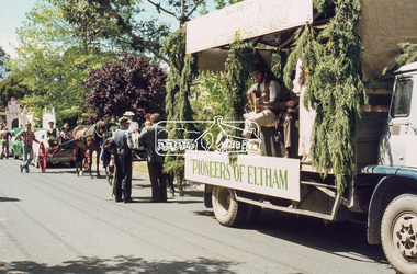 Eltham District Historical Society Inc
Slide, Grand Parade, Eltham Community Festival, 17 Oct. 1981
The 1981 Eltham Community Festival was held from 16th to 18th October, with the festival parade being held on Saturday 17th. In recent years the Society had participated in the parade and a display for the festival, winning prizes for the Society’s float in 1979, 1980 and again in 1981 with a prize for the best effort by a local group, donated by Bob Clarke's Menswear. Peter Quirke provided the use of his truck as a float. Peter had formerly operated his fruiterer's business at Research and Diamond Creek and in 1981 opened a shop in the Eltham Village Arcade. Joh Ebeli, with assistance from other members decorated the float. Members of the Victorian Folk Music Club accompanied the Society on the float and their music helped create the appropriate mood. A new feature of the Society’s 1981 parade entry was the inclusion of horse drawn vehicles owned and driven by the Hennel family of Hurstbridge, which added to a highly successful day. Society member and long-time Eltham resident, Jock Read also won an award for the “Best Eltham Theme.” Jock and his horse were a feature of Eltham parades for many years and he also established a local tradition in leading Anzac Day parades. 35 mm colour positive transparency (1 of 5) Mount - Agfachrome Agfa CS System black 8 dotseltham festival, parade, parade floats, pioneers of eltham, shire of eltham historical society, cecil street, victorian folk music club