Showing 915 items
matching railway park
-
 Kew Historical Society Inc
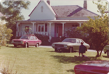
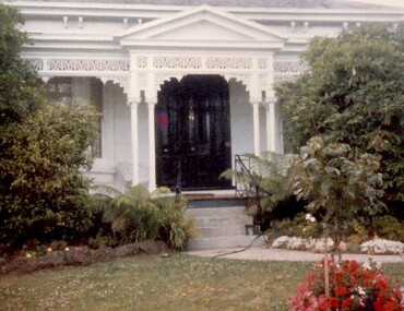
Photograph - 'Neama', Studley Park Road, 1978
Edward Augustus Atkyns was born in Wiltshire, England in 1840. His family emigrated to Australia in 1852. As a young man he was a keen cricketer and played at the first cricket ground in the district, located between Barkers Road and Hawthorn Grove, on the site of the future Barker railway station. Atkyns was admitted to the Victorian Bar in 1861, initially working in his father’s practice. He sat as a local magistrate in both Kew and Hawthorn and acted as solicitor for several shire councils. Elected to the Hawthorn Borough Council in 1863 at the age of 23, he served in that municipality as mayor in 1866-67. By 1877, he had moved to Kew where he lived at Neama in Studley Park Road, a property later incorporated into the St Paul’s School for the Blind.Rare colour photograph of what was once a significant house in Kew.Original colour positive photograph (Kodak print) of the main house of 'Neama', colloquially known as the 'farmhouse'. Photographed by Stewart West in April 1978 (it was later demolished by the Villa Maria Society).Annotated reverse: "Front view of Neama / Farmhouse on St Paul's School for the Blind Children / Fernhurst Estate"st paul's school for the blind, neama, studley park road -- kew (vic.), historic houses -- kew (vic.), villa maria society -
 Kew Historical Society Inc
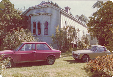
Photograph - 'Neama', Studley Park Road, 1978
Edward Augustus Atkyns was born in Wiltshire, England in 1840. His family emigrated to Australia in 1852. As a young man he was a keen cricketer and played at the first cricket ground in the district, located between Barkers Road and Hawthorn Grove, on the site of the future Barker railway station. Atkyns was admitted to the Victorian Bar in 1861, initially working in his father’s practice. He sat as a local magistrate in both Kew and Hawthorn and acted as solicitor for several shire councils. Elected to the Hawthorn Borough Council in 1863 at the age of 23, he served in that municipality as mayor in 1866-67. By 1877, he had moved to Kew where he lived at Neama in Studley Park Road, a property later incorporated into the St Paul’s School for the Blind.Rare colour photograph of what was once a significant house in Kew.Original colour positive photograph (Kodak print) of the secondary building at 'Neama', colloquially known as the 'hall'. Photographed by Stewart West in April 1978 (it was later demolished by the Villa Maria Society).Annotated reverse: "Timber hall on Fernhurst land / Transported there approx 1878."st paul's school for the blind, neama, studley park road -- kew (vic.), historic houses -- kew (vic.), villa maria society -
 Kew Historical Society Inc
Plan, Studley Park Estate, 1910
Prue Sanderson, in her groundbreaking ‘City of Kew Urban Conservation Study : Volume 2 - Development History’ (1988), summarised the periods of urban development and subdivisions of land in Kew. The periods that she identified included 1845-1880, 1880-1893, 1893-1921, 1921-1933, 1933-1943, and Post-War Development. These periods were selected as they represented periods of rapid growth or decline in urban development. An obvious starting point for Sanderson’s groupings involved population growth and the associated economic cycles. These cycles also highlighted urban expansion onto land that was predominantly rural, although in other cases it represented the decline and breakup of large estates. A number of the plans in the Kew Historical Society’s collection can also be found in other collections, such as those of the State Library of Victoria and the Boroondara Library Service. A number are however unique to the collection.The Kew Historical Society collection includes almost 100 subdivision plans pertaining to suburbs of the City of Melbourne. Most of these are of Kew, Kew East or Studley Park, although a smaller number are plans of Camberwell, Deepdene, Balwyn and Hawthorn. It is believed that the majority of the plans were gifted to the Society by persons connected with the real estate firm - J. R. Mathers and McMillan, 136 Cotham Road, Kew. The Plans in the collection are rarely in pristine form, being working plans on which the agent would write notes and record lots sold and the prices of these. The subdivision plans are historically significant examples of the growth of urban Melbourne from the beginning of the 20th Century up until the 1980s. A number of the plans are double-sided and often include a photograph on the reverse. A number of the latter are by noted photographers such as J.E. Barnes.Coloured lithograph of a subdivision plan of the Studley Park Estate, bordered by Yarra, Willsmere Road and the Outer Circle Railway line. The estate was listed in 1910 and was the subject of a planning dispute between the developer and the Town of Kew in relation to flood levels and the suitability of the land for housing. In many cases the names of streets were subsequently changed. The layout was also affected by the creation of the Eastern Freeway. A newspaper report of the day described the subdivision as a: "GOLDEN OPPORTUNITY. We are pleased to submit for PRIVATE SALE that magnificent ESTATE, situated only 4 1/2 miles from the Melbourne General Post Office, STUDLEY PARK ESTATE. KF/NV. Doubtless the CHEAPEST LAND EVER OFFERED having extensive frontages to the prettiest spot on the River Yarra and the National Park, commanding lovely river and landscape views, and acknowledged to be the finest land available so close to the city. The PRICES ARE EXTREMELY MODERATE; The TERMS ARE SIMPLY MARVELLOUS. NO DEPOSIT. NO DEPOSIT. NO DEPOSIT. Allotments and prices to suit everyone."subdivision plans - kew, studley park estate -
 Kew Historical Society Inc
Plan - Subdivision Plan, Wimba Estate, Kew, c.1925-c.1929, ca. 1925-ca. 1929
Pru Sanderson, in her groundbreaking ‘City of Kew Urban Conservation Study : Volume 2 - Development History’ (1988), summarised the periods of urban development and subdivisions of land in Kew. The periods that she identified included 1845-1880, 1880-1893, 1893-1921, 1921-1933, 1933-1943, and Post-War Development. These periods were selected as they represented periods of rapid growth or decline in urban development. An obvious starting point for Sanderson’s groupings involved population growth and the associated economic cycles. These cycles also highlighted urban expansion onto land that was predominantly rural, although in other cases it represented the decline and breakup of large estates. A number of the plans in the Kew Historical Society’s collection can also be found in other collections, such as those of the State Library of Victoria and the Boroondara Library Service. A number are however unique to the collection.Subdivision plans are historically important documents used as evidence of the growth of suburbs in Australia. They frequently provide information about when the land was sold on which a built structure was subsequently constructed as well as evidence relating to surveyors and real estate and financial agents. The numerous subdivision plans in the Kew Historical Society's collection represent working documents, ranging from the initial sketches made in planning a subdivision to printed plans on which auctioneers or agents listed the prices for which individual lots were sold. In a number of cases, the reverse of a subdivision plan in the collection includes a photograph of a house that was also for sale by the agent. These photographs provide significant heritage information relating house design and decoration, fencing and household gardens.In 1925, the City of Kew called for tenders for the construction of Wimba Avenue, Cadow Street and Lalla Street. Subsequent advertisements for the sale of land in Wimba Avenue continued from 1926 to 1929. The 18 lots (and a further five allotments on the eastern side of the street) offered for sale were unofficially described in the subdivision plan as the ‘Wimba Estate’. These lots began in Park Hill Road and extended almost to Cotham Road. The subdivision took its name from the house ‘Wimba’ in Cotham Road, which may have formed the southern boundary of the subdivision. (Wimba, at 235 Cotham Road was constructed between 1862-70). The Plan highlights the proximity and advantage of ‘electric’ trams in Cotham and Glenferrie Roads, and the Kew and Glenferrie Railway Stations. An oddity in the Plan is the reference to the electric tram terminus at Burke Road, given that the tramline had already been extended to Mont Albert in 1916.wimba estate, subdivision plans - kew, parkhill road – kew (vic.), normanby road – kew (vic.), wimba avenue – kew (vic.) -
 Kew Historical Society Inc
Plan, J R Mathers & McMillan, 5 Splendid vVlla Allotments,: Segtoune St. & Windsor St., Kew, 1928
Prue Sanderson, in her groundbreaking ‘City of Kew Urban Conservation Study : Volume 2 - Development History’ (1988), summarised the periods of urban development and subdivisions of land in Kew. The periods that she identified included 1845-1880, 1880-1893, 1893-1921, 1921-1933, 1933-1943, and Post-War Development. These periods were selected as they represented periods of rapid growth or decline in urban development. An obvious starting point for Sanderson’s groupings involved population growth and the associated economic cycles. These cycles also highlighted urban expansion onto land that was predominantly rural, although in other cases it represented the decline and breakup of large estates. A number of the plans in the Kew Historical Society’s collection can also be found in other collections, such as those of the State Library of Victoria and the Boroondara Library Service. A number are however unique to the collection.Subdivision plans are historically important documents used as evidence of the growth of suburbs in Australia. They frequently provide information about when the land was sold on which a built structure was subsequently constructed as well as evidence relating to surveyors and real estate and financial agents. The numerous subdivision plans in the Kew Historical Society's collection represent working documents, ranging from the initial sketches made in planning a subdivision to printed plans on which auctioneers or agents listed the prices for which individual lots were sold. In a number of cases, the reverse of a subdivision plan in the collection includes a photograph of a house that was also for sale by the agent. These photographs provide significant heritage information relating house design and decoration, fencing and household gardens.In 1928, five residential allotments bordering Segtoune and Windsor Streets were advertised for sale as part of a subdivision. Four of the blocks faced Segtoune Avenue. The auctioneers proclaimed the advantages of the sites: ‘Situate one minute from the High Street Electric Tram, which now runs direct to Spencer Street via Bridge Road and Flinders Street. Opposite the East Kew Railway Station (Outer Circle Line), which may be reopened In connection with the new Line from Kew to Doncaster; Adjacent lo the Kew Recreation Reserve, Sports Oval, and Swimming Bath; Half Minute from the Shopping Centre of East Kew, Accessible to the State School and Other Educational Centres’. The Harp of Erin Hotel and the route of the Outer Circle Railway line are marked on the plan. The Recreation Reserve and Sport Oval refer to Victoria Park. The Swimming Baths were located on the site of the current Kew Recreation Centre.subdivision plans - kew, segtoune street -- kew (vic.), windsor street -- kew (vic.) -
 Kew Historical Society Inc
Plan - Subdivision Plan, Camberwell Mountain View Estate, 1923
The Kew Historical Society collection includes almost 100 subdivision plans pertaining to suburbs of the City of Melbourne. Most of these are of Kew, Kew East or Studley Park, although a smaller number are plans of Camberwell, Deepdene, Balwyn and Hawthorn. It is believed that the majority of the plans were gifted to the Society by persons connected with the real estate firm - J. R. Mathers and McMillan, 136 Cotham Road, Kew. The Plans in the collection are rarely in pristine form, being working plans on which the agent would write notes and record lots sold and the prices of these. The subdivision plans are historically significant examples of the growth of urban Melbourne from the beginning of the 20th Century up until the 1980s. A number of the plans are double-sided and often include a photograph on the reverse. A number of the latter are by noted photographers such as J.E. Barnes.The so-called Camberwell Mountain View Estate was a subdivision on ‘the corner [of] Burke Road, Eyre and Wills Streets, Deepdene’. The Estate was not the first attempt to subdivide this land holding. In 1884, 1888 and 1894 the Belmore Park subdivision proposed 18 allotments for this parcel of land. The final stages of the Belmore Park subdivision occurred during the Depression of the 1890s. Apart from perhaps one block facing Burke Road, which is unnumbered in the Mountain View Estate subdivision, the rest must have remained unsold. The later subdivision would redraw the original 18 allotments, creating 22 new lots. In the Locality Plan on the left side of the subdivision plan, Deepdene Station, which formed part of the Outer Circle Railway is represented, as is the location of Deepdene Primary School. A selling point was the proposed extension of the Burke Road tram beyond its terminus at Cotham Road. The extension did not eventuate.subdivision plans - camberwell, mountain view estate -
 Kew Historical Society Inc
Container - Presentation Jewellery Box, 1948
In 1948, the citizens of Kew presented this jewellery box to the outgoing Mayor and Mayoress of Kew, Cr & Mrs W D Vaughan. In 2021, it returned to Kew, thanks to the generous donations of our Friends of the Collection. William David Vaughan to whom the jewel box was presented in 1948 was a publisher, politician and historian, born in 1897 at Heathcote. By 1922, he had become a publisher and Secretary of Victorian Newspapers Ltd. In October 1922, he married Muriel Gladys Frazer in Bendigo. He purchased 'Elsfield' in Cotham Road, renamed it 'Carramar', and resided there for almost fifty years. His wife, the Mayoress, was an accomplished pianist and entertained the wives of councillors and supported many charitable works from her home. In 1926, Vaughan founded a local newspaper, the Kew Advertiser. During his second term as Mayor, he was elected president of Melbourne Suburban Newspapers’ Association, In April 1947, he was appointed to and later became chairman of the Free Library Services Board. In 1960, he published his history of Kew - 'Kew's Civic Century'. Vaughan’s third term as Mayor in 1962-63 saw the erection of the pavilion at Victoria Park and the final clean-up of the Outer Circle Railway. He died in September 1976. This inlaid and engraved jewellery box was part of a larger donation made to the Mayor and Mayoress of Kew in 1948 by the citizens of the municipality. It is the only 'civic award' in the collection given to a former civic leader and complements the large collection of civic portraits in the collection. The box is additionally significant because of its association with William David Vaughan - newspaper proprietor, local politician, and local historian. A presentation jewellery box, she-oak with barber pole inlay adorned with an Australian silver plaque.Engraved inscription on silver plaque - "Presented to Cr & Mrs W.D. Vaughan With The Esteem And Appreciation Of The Citizens Of Kew And In Recognition Of their Services As Mayor And Mayoress 1947-48. 28th July 1948"w d vaughan, mayors of kew, kew advertiser, kew (vic.) -- history -
 Kew Historical Society Inc
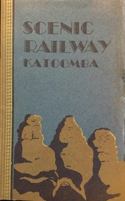
Booklet, The Scenic Railway and the Mountain Devil: the steepest incline railway in the world
Descriptive story of the Katoomba scenic railway by Vivian Pynor.Cover in two colours depicts design of ‘Three Sisters’, 8 unnumbered pages, 8 unnumbered pages of plates : illustrations (some colour) ; 20 cmnon-fictionDescriptive story of the Katoomba scenic railway by Vivian Pynor.katoomba - railways, christian-washfold collection -
 Kew Historical Society Inc
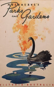
Booklet, Victorian Railways, Melbourne's Parks and Gardens, c.1941
"A little gallery of pictures revealing the created loveliness of the city's open public spaces ; all on the fringe of the busy metropolis, and all possessing some particular quality - some favoured lawn, tree or flower effect - to hold the lover of growing things"Tourist brochure describing parks and gardens in Melbourne produced and printed by the Victorian Railways in 1941. Mainly Botanic and Fitzroy Gardens. "A little gallery of pictures revealing the created loveliness of the city's open public spaces ; all on the fringe of the busy metropolis, and all possessing some particular quality - some favoured lawn, tree or flower effect - to hold the lover of growing things"melbourne (vic) -- parks and gardens, christian-washfold collection -
 Kew Historical Society Inc
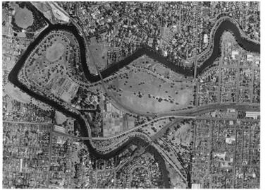
Map, MMBW, River Yarra Beautification Schemes, c.1913
The Melbourne and Metropolitan Board of Works (MMBW) was established by an act of the Victorian Parliament in 1890 to prepare for and to implement a sewerage and water reticulation system across what was then inner Melbourne, its surrounding and middle distance suburbs, including Kew. The MMBW was disbanded in 1991.The map collection of the Kew Historical Society has at its core the historic maps assembled and originally stored in the City Engineer's Department of the City of Kew. These include maps in a number of scales. The vast majority of maps were produced by the MMBW in the first two decades of the twentieth century, and are solid working maps, backed by linen for durability. These maps are historically significant to Kew, the City of Boroondara and to the history of the development of state utilities in Victoria. A number of the Kew maps have additional details added by former municipal officers, including the levels reached by various floods. As these were working documents, information was added to them long after the period of their initial production and distribution.Map of the City of Kew showing part of the River Yarra Beautification Schemes. The map shows development to date and the flood levels reached in 1923 and 1924. This map may have been adapted from an earlier map, as most development in central Kew and Studley Park had occurred by this date yet numerous streets are not represented. Public buildings and institutions are clearly represented and named on the map as are significant public transport infrastructure (eg the Outer Circle railway).MELBOURNE AND METROPOLITAN BOARD OF WORKS / RIVER YARRA BEAUTIFICATION SCHEMES / SCHEME / SCALE 10 CHAINS TO AN INCHmelbourne & metropolitan board of works, mmbw maps, mmbw plans, city of kew, flood levels -- kew (vic.), cartography -
 Brimbank City Council Art Collection
Drawing, Afternoon, Sunshine, 1984
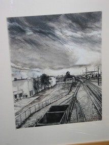
Local Scene of the railways, probably as viewed from the Sunshine OverpassGary James. Afternoon, Sunshine. Charcoal on paper, 45 x 36cm, View of the railway tracks with carriages on the foreground left - AR0067 -
 Sunbury Family History and Heritage Society Inc.
Photograph, 25th
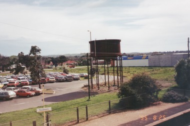
The photograph of Sunbury was taken from the pedestrian bridge at the railway station and is looking NW to Horne Street and beyond. The water tower in the foreground was used to pump water into the steam train engines. Then commercial development on the site was built shortly before this photograph was taken.A coloured photograph of an elevated view of Sunbury with a metal water tower in the foreground and a car park with commercial buildings in the middle distance.sunbury, sunbury railway station, horne street -
 Sunbury Family History and Heritage Society Inc.
Photograph, 15th August 1995
The house was the former station master's residence. When the photograph was taken it served as a restaurant. In the late 1990s it was demolished to make way for larger commercial development.The former stationmaster's residence was one of the important buildings in Sunbury.A coloured photograph of a cream weatherboard house with light green trims surrounded by a garden. Four cars are parked outside the house.sunbury railway station, stationmaster's residence, brook street -
 Sunbury Family History and Heritage Society Inc.
Photograph, September 1996
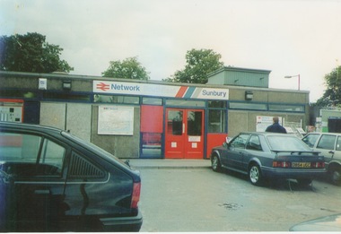
The photograph shows the railway station at Sunbury in Surrey in the United Kingdom. The town of Sunbury in Victoria was named after the English township of Sunbury-on-Thames in Middlesex by the Jackson Brothers who took up land in Sunbury, Victoria. The area was originally known as Koora Kooracup by the Wurundjeri people.Sunbury in Victoria like many other settlements in Australia were given names of towns in the United KingdomA coloured photograph of a railway station with three cars parked outside the building, which has grey walls and scarlet and blue trims. There are framed maps and notices on the exterior walls. -
 Surrey Hills Historical Society Collection
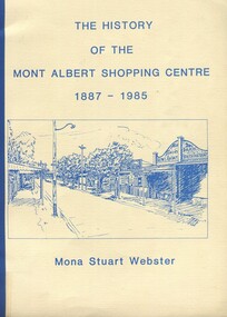
Book, Box Hill Historical Society et al, The history of the Mont Albert Shopping Centre, 1986
Born in 1900, Mona was the daughter of Florence Jane McDowall Stuart (1867-1936) and George Hudson Grant (1864-1910) who married in 1899. He was a surveyor and they lived in Albany Crescent, Surrey Hills. Her full name was Jessie Mona Stuart Grant and she had a sister Mollie. In 1924 she married Clarence William Willoughby Webster (1895-1980) - SERN 33286. Clarence was born in Thorpedale where his father was a teacher. He was living in View Street Mont Albert and was a law student when he enlisted on 3 October 1916. After discharge on 10 May 1919, Clarence returned to his studies. He joined a legal firm in the city which became Pearce & Webster (later Pearce Webster Dugdale). Mona and Clarence lived in Surrey Hills and Mont Albert in a number of homes for the remainder of their lives.A history of the Mont Albert Shopping Centre in Hamilton Street, Mont Albert, including the early land use, and a chronology of shop owners. Index, photos., 39p. Compiled by local resident, Mona Webster.On front cover: top RH corner "Kay Kirkwood/98995158"phoenix park estate, mont albert, hamilton street, (mr) - mckerdy, (mr) - andrew, (mr) - dunn, (lady) emma hamilton, railways, churchill street, surrey hills golf club, (mrs) mona webster -
 Surrey Hills Historical Society Collection
Photograph, 101 Guildford Road, Surrey Hills
The house was built in 1883, possibly to encourage development of housing on the first urban land subdivision in Surrey Hills, the Windsor Park Estate (in the Windsor Crescent area). This coincided with the opening of the Surrey Hills Railway station. The first occupant was John Brown Nicholson, police magistrate. In 1884 the foundation meeting of the Wyclif Congregational Church was held in the house.Colour photo of the front door and verandah of 101 Guildford Road taken from the street. The house is Victorian in style with ornate lacework along the verandah. It is painted white and has a slate roof. There is a well-maintained garden with flower beds and shrubs, which partially obscure the house.victorian style, wyclif church, houses, guildford road, john brown nicholson -
 Surrey Hills Historical Society Collection
Photograph, 'Maitland', 1 Bedford Avenue, Surrey Hills, c 1900, 1900
Maitland' was built in 1889 for Thomas Zeplin, who was a Professor of Music. He owned all the land bound by Union Road, Wilson and Montrose Streets and the railway line. 1 Bedford Avenue stayed in family ownership until purchased by Camberwell Council in 1986, initially for a car park. However it was renovated to become part of Surrey Hills Neighbourhood Centre. It was opened on 23 November 1990. No 3 Bedford Avenue was built for Thomas Zeplin's daughter and named 'Mervyl' or 'Merryl'. Mrs Brodecky (donor) was the great-granddaughter of Thomas Zeplin. The 2 girls are granddaughters of Thomas Zeplin. Electoral roll information: 1972 & 1977: Albert Vojteck Brodecky, manager, 1 Bedford Avenue. 1977: Ray Nanette Brodecky. There are 2 copies. Thomas had this built for his son and family. The house was occupied by his family, though sometimes rented out. His great-grand-daughter Mrs. A. Brodecky sold to the Camberwell Council in 1986. This was the only surviving photo in the family after the fire. Courtesy: Mrs. A. BrodeckyBlack and white photo of 2 houses taken from the street front. On the LHS is a Victorian double-fronted single-storey villa of Hawthorn brick construction, with wrought iron lacework to the veranda, slate roof and picket fence, with an established garden. Next door at No 3 is a double-storey Victorian terrace with a similar fence and building materials. There are 2 young girls standing in front between the properties.maitland, bedford avenue, 1900, surrey hills neighbourhood centre, victorian style, mervyl, merryl, mr thomas zeplin, mrs nanette brodecky, mr albert vojteck brodecky -
 Surrey Hills Historical Society Collection
Photograph, Surrey Hills railway station, 1973, 1973
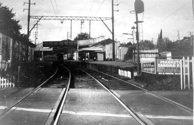
This would have been taken shortly before the station was demolished.Black and white photo of Surrey Hills railway station taken from the tracks near the gates in 1973. It shows the wooden pedestrian overpass and the original station buildings with extended shelters over the platforms.There is a newspaper kiosk on the southern platform. The train is coming into the platform and there is a small group of passengers waiting. Advertising hoarding for Spaceline Homes and the Frankston Caravan Park are mounted at the end of the southern platform. railways, land transport, surrey hills railway station -
 Surrey Hills Historical Society Collection
Photograph, Surrey Hills Station and car park
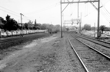
... railway houses at the Mont Albert end of the northern car park ...There are 3 tracks; the third track was built in 1971, which gives an approximate date for the photo. At this time the original station buildings were demolished and replaced by buildings constructed from concrete bricks and a second subway replaced the overhead footbridge. According to Roderick Smith, a local railway enthusiast, originally there had been 3 railway houses at the Mont Albert end of the northern car park. These were demolished to extend the car park. Certainly 8 Bedford Avenue, built as the station master's house was demolished at this time. The palm tree had been planted in the station master's front garden and was retained in a small garden bed within the car park. A black and white photograph of a station with cars parked on both sides of the 3 tracks. A Harris train is departing the station heading towards Mont Albert. A palm tree is prominent in the station car park to the north.1971, surrey hills station, railway stations, car parks, public transport, trains, railway lines, palm tree -
 Surrey Hills Historical Society Collection
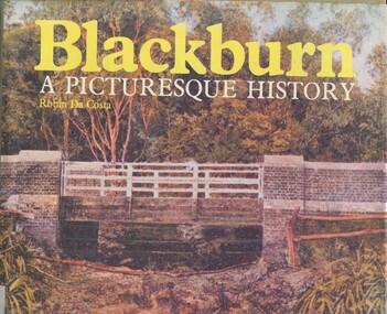
Book, Blackburn: A Picturesque History, 1978
This book focuses on the area's history and traces the development through settlement, adaptation and consolidation to the present. It discusses the history of early families, the railway, land boomers, churches and school. Robin da Costa, later Mrs Robin da Costa- Adams, came to live in Balwyn Road, Canterbury and joined the Canterbury History Group.Hardback book of 144 pages, indexed with multiple black and white photos.In Jocelyn Hall's writing: "Donated to Surrey Hills Neighbourhood Centre".(mr) james blackburn, meader's travellers' rest hotel, blackburn hotel, blackburn post office, blackburn railway station, blackburn pioneers, blackburn company, (mr) george augustus goodwin, (mr) thomas r b morton, blackburn brick works, st john's anglican church, blackburn methodist church, blackburn church of christ, blackburn presbyterian church, st thomas the apostle peace memorial church, seagoe common school, the courier blackburn, blackburn library, blackburn primary school, blackburn open-air school, blackburn creek hotel, blackburn college, blackburn kindergarten, newark grammar, blackburn hall, morton park, blackburn lake sanctuary, backhouse's dairy, blackburn lake, wandinong sanctuary, barelli bakehouse, blackburn cool store, blue moon fruit co-operative ltd, 1st blackburn scouts troop, blackburn and district tree preservation society, hotels, (ms) robin da costa -
 Surrey Hills Historical Society Collection
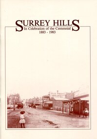
Book, Surrey Hills: in celebration of the centennial 1883-1983, 1983
A pictorial history of Surrey Hills based on information collected and based at the Surrey Hills Neighbourhood Centre. It includes early rural properties and diaries, the coming of the railway, land sub-division and early homes, schools, parks and recreation.A pictorial history of Surrey Hills based on information collected and based at the Surrey Hills Neighbourhood Centre. It includes early rural properties and diaries, the coming of the railway, land sub-division and early homes, schools, parks and recreation.surrey hills, railways, land use, migrants, spanish communities, transport, houses, wattle park, festivals and celebrations, churches, education, water supply, fire stations, hospitals, (mr) george klepper, ainger family, (mr) john woodhead, (mr) h. breedon, medical services, real estate agents, businesses, musical events and activities, entertainment, parks and reserves, scouts, guides -
 Surrey Hills Historical Society Collection
Book, Surrey Hills: in celebration of the centennial 1883-1983, Reprinted November 1992
A pictorial history of Surrey Hills and Mont Albert based on information collected by the history group at the Surrey Hills Neighbourhood Centre. It includes information about early rural properties and dairies, the coming of the railway, land sub-division and early homes, doctors, schools, churches, parks and recreation facilities.A pictorial history of Surrey Hills based on information collected and based at the Surrey Hills Neighbourhood Centre. It includes early rural properties and diaries, the coming of the railway, land sub-division and early homes, schools, parks and recreation.1992surrey hills, railways, land use, migrants, spanish communities, transport, houses, wattle park, festivals and celebrations, churches, education, water supply, fire stations, hospitals, (mr) george klepper, ainger family, (mr) john woodhead, (mr) h. breedon, medical services, real estate agents, businesses, musical events and activities, entertainment, parks and reserves, scouts, guides -
 University of Melbourne, Burnley Campus Archives
Plan, Egg Laying Competition
... , vehicle park, tennis court and railway line.... by potting sheds, vehicle park, tennis court and railway line. Egg ...Copy of plan for fencing. Area bounded by potting sheds, vehicle park, tennis court and railway line.fencing, tennis court, vehicle park, egg laying, competition -
 Surrey Hills Historical Society Collection
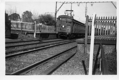
Digital photo, George L Coop, Surrey Hills railway station, October 1958, October 1958
Trains with electric swing doors were often referred to as "dog boxes" or "doggies". They were manufactured at the Newport Workshops for the Victorian Railways. Swing Door cars had outward-opening doors. They were reasonably narrow, to ensure that two passing trains would not foul each other if doors were accidentally left open. The donor George Lister Coop was about 21 years of age when he took this photo. He advised that in order to access this point he had to scramble through a bit of rough undergrowth and beginnings of a car park. All near an open drain of some kind. It is one of a small series of photos donated by him that relate to Mont Albert and Surrey Hills stations. George has always had an interest in railways and there are other examples of his documentation of railway history in other collections contributing to this database. A black & white photo of a swing door train destined for Flinders Street that is within the platforms at Surrey Hills. The photo is taken from the western end of Surrey Hills Station. There is a man near the end of the platform on the north side. He is probably a railway worker heading towards his work shed just seen on extreme left. george l coop, railway stations, swing door trains, trains -
 Vision Australia
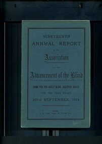
Administrative record - Text, Nineteenth Annual Report of the Association for the Advancement of the Blind 1914, 1914
Annual report of the Association for the Advancement of the Blind outlined activities and events over the year, including the opening of the new wing at the Adult Home for the Blind by Lady Denman, removal of a 300 pound debt due the combined efforts of the Police, Military and Fire Brigades who hosted a monster carnival at Luna Park to raise funds for this, and with the help of the Minister of Railways - Hon. Donald Mackinnon - free suburban train for guides has now been granted.1 volume of printed material with some illustrationsassociation for the advancement of the blind, annual reports -
 University of Melbourne, Burnley Campus Archives
Photograph - Black and white prints, Aerial View of Burnley Campus, 1963-1970
Freeway was not begun until 1968.Black and white photographs. Aerial View of Burnley Campus. (B) Original of (A). Enlargement (C) Laminated copy(A) Inscribed on reverse, "South Eastern Freeway 9.7.63 R22.024.439." (C) Paper attachment: The Burnley College Portion of Richmond Park in 1972. Swan Street Takes Its Familiar Route. The Boulevard Has Been Constructed. The Golf Course is in Place. The Series of Parallel Buildings Along the Railway Line at the Bottom of the Photo Are the Poultry Sheds Used For Egg-Laying Competitions. Burnley Sidings Were Still to be Built. In the Mid-1990's Much of the Western Portion of the College Grounds/Richmond Park Was Sold.burnley campus, aerial view, south eastern freeway, richmond park, swan street, yarra boulevard, richmond golf course, poultry sheds -
Canterbury History Group
Photograph - Canterbury Park, c1990
... . Includes Bowling green and railway line. Photograph Canterbury Park ...Black and White photograph of Canterbury Park from Canterbury Road looking towards the park. Includes Bowling green and railway line.canterbury, canterbury road, canterbury park, canterbury bowling club, railway lines -
 Parks Victoria - Mount Buffalo Chalet
Seat
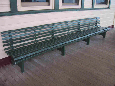
Appears to be a Victorian Railways platform seat dated possibly from 1925 onwards when Victorian Railways assumed management of the Chalet. 4 other slatted bench seats are sited in the the games room which was built in 1925. '(Fig 43. Four bench seats like this example on the front verandah are in the Billiard Room. they resemble furnishings used by the Victorian Railways.' ( Pg56. Historica Cultural Heritage Project. Mount Buffalo Chalet Collection. Prepared for Parks victoria, 2011) Listed in Appendix A. Draft Inventory of significant Collection Items. (Pg 162 Historica.)Listed in Draft Inventory of Significant Collection ItemsLong green painted wooden seat. Made of slats with four leg supports (some are metal) at regular intervals. Slightly curved back. -
 Parks Victoria - Mount Buffalo Chalet
Clock
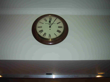
Appears to be an original piece from Mt Buffalo Chalet. Purpose made for the Chalet as inscribe d with Mount Buffalo Chalet to Clock face most likely in Victorian Railways era, post 1924.. "Interestingly, the photograph indicates that a big round clock was mounted on the fenestration just behind and above the cabinet (fig 36). Reminiscent of railway clocks, it was perhaps introduced by the Victorian Railways after 1924. it resembles the clock that was subsequently mounted on the wall above the Chalet reception desk, and more recently stored away for safety with other movable items in the Chalet. Closer comparison however seems to indicate that the two clocks have different wooden frames and probably differ in diameter." "A number of specific items, which have been useful in the day to day operations of the chalet, remain in the building, with each complementing the other to provide context, meaning and character to their setting. items such as the hall porter bell, the many signs providing information to guests, the wall clock, barometer and dinner bell point to the Chalet being a well-run social institution with a pleasant environment for rest, recreation and congenial company." (Pg 81, Historica, MBCC)Large circular clock with "Mount Buffalo Chalet" printed in black on face. Clock has Roman numerals in black with two black hands against a white face. Wooden , circular frame. "Mount Buffalo Chalet" -
 Parks Victoria - Mount Buffalo Chalet
Desks
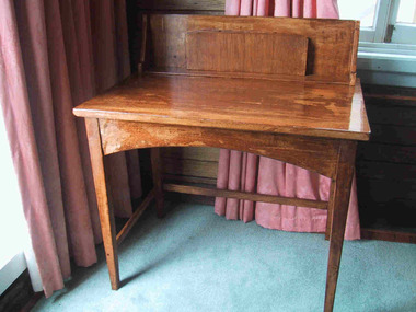
This small writing desk currently in the 'Smoker's ' lounge or Drawing Room can be seen in Victorian Railways photographs dated between 1925 and 1930's. This writing table has a raised back containing compartments for stationery printed with the Chalet letterhead provided for Guests to write letters and post cards. "Photographs of the main lounge taken between 1925 and the 30's confirm that the room was equipped with at least 2 small writing desks... Made of light coloured wood, they have raised backs containing compartments for stationery printed with the chalet letterhead. Two of the same historic desks remain at the Chalet today." Listed in Draft Inventory of Significant Collection Items. Two small blonde wood writing desks. Has backboard with upright document slots. Varnish is irregular.