Showing 8329 items matching "bridging"
-
 Port Melbourne Historical & Preservation Society
Photograph - Letter 'L' from RSL on gate on Bridge Street side of Excelsior Hall, Port Melbourne, David Thompson, Jun 1998
On ending of RSL lease and therefore imminent sale and development of the land - Princes to Station at Bridge - David THOMPSON recorded exterior details of the building.Photo: detail of 'L' from gate at Bridge Street side, from series of photos of Excelsior Hall ('Diggers' Hall'), RSL Port Melbourne branch headquarters 1948 - 1998. Made June 1998 by David THOMPSON.societies clubs unions and other organisations, excelsior hall, built environment, returned services league, rsl -
Port Melbourne Historical & Preservation Society
Photograph - Excelsior Hall from corner Princes and Bridge Streets, Port Melbourne, David Thompson, Jun 1998
On ending of RSL lease and therefore imminent sale and development of the land - Princes to Station at Bridge - David THOMPSON recorded exterior details of the building.Photo: view from Princes and Bridge Streets, showing Dispensary. From series of photos of Excelsior Hall ('Diggers' Hall'), RSL Port Melbourne branch headquarters 1948 - 1998. Made June 1998 by David THOMPSON.societies clubs unions and other organisations, excelsior hall, built environment, returned services league, rsl -
 Kew Historical Society Inc
Photograph - Construction of the Eastern Freeway (F19), Ron Setford, November 1972
Ron Setford and his wife Grace Setford lived in Tanner Avenue, East Kew, from c.1946 to c.1995. A keen photographer, he recorded the changing face of Kew over a 20 year period. Apart from 30 photographs of built structures and places in Kew dating from 1960 and 1961, 145 of his 35mm colour slides chronicle the development of the F19 (later renamed Eastern) Freeway through the Yarra Valley in Kew over a five year period from c.1972 to c.1977. This important collection was donated to the Society by his granddaughter in 2025.This collection of 175 35mm slides is of local and statewide significance, owing to its subject matter, particularly the major development of road transport infrastructure during the 1970s with the construction of the Eastern Freeway. The photographer also took care to annotate and date most of his slides which enable the researcher to pinpoint temporal and spatial locations."Temporary across bridge at rear / New bridge embankments / Kew - Fairfield"ron setford, eastern freeway, f19 freeway -
 Lakes Entrance Historical Society
Postcard - Views of Lakes Entrance c1972, 1972 c
Princes Highway looking down to North Arm bridge with town in distance, people camped on North Arm foreshore and car towing caravan in foreground Lakes Entrance VictoriaColour postcard taken from Princes Highway looking down to North Arm bridge with town in distance, people camped on North Arm foreshore and car towing caravan in foreground Lakes Entrance VictoriaGreetings from Lakes Entrancebridges, roads and streets, township, vehicles -
 Bendigo Historical Society Inc.
Photograph - ROBERT DENIS KELLY COLLECTION: BRIDGE TO SOUS LE BOIS
Black and white photo: bridge over river, bridge is collapsed in middle. Written on back 'Bridge to Sous Le Bois'.person, robert denis kelly, world war 1, bridge, france, sous le bois. -
 Melton City Libraries
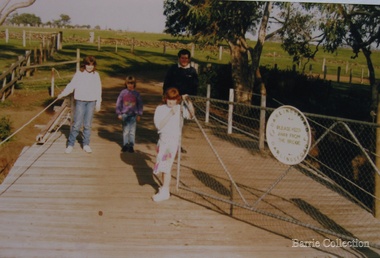
Photograph, Geoff Collins, Debbie, Coralie and Kim Barrie, 1987
Charles Ernest Barrie b. Ballarat 1871 d. 1931 In May 1911 he purchased the property known as ‘Darlingsford.’ The name of the property is derived from Thomas Bell Darling the purchaser of 176 acres of Crown Grant land on the 29-3-1853 which formed part of the Barrie farm acreage. His three sons continued in the family farming tradition in Melton for the rest of their lives. By 1982 the last remaining connection with the ‘Darlingsford’ property and the Barries. Sons, Ernest (Bon) finally ceased. Edgar died in 1975, Ernest in 1985 and Tom in 1990. Bridge built in 1915. Geoff Collins, Debbie, Coralie and Kim Barrie entering Darlingsford property over bridge built in 1915local identities, landscapes of significance -
 Bendigo Military Museum
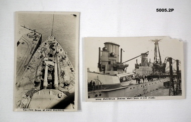
Postcard - POSTCARDS OF HMAS AUSTRALIA IN 1920, Royal Australian Navy, c1920's
1. B & W postcard shows scene of foredeck taken from the bridge. One twin gun turret can be observed. The ship is tied up at a wharf. 2. Side view of HMAS AUSTRALIA. The photo shows one gun turret, two funnels and wireless mast.1. On front bottom is handwritten "View from bridge of HMAS AUSTRALIA". 2. On front bottom is written "HMAS AUSTRALIA during Navy days in the 1920's" .photographs, ran, hmas australia -
 Orbost & District Historical Society
pamphlets, Princes Freeway - Orbost Section, 1976
Opened by the Hon. J A Rafferty, Minister for Transport, 25 November 1976, the bridge was the first of four bridges to be built as part of the freeway bypass of Orbost. Construction cost $2.4 million. This construction was an important development along the Princes Highway corridor through East Gippsland. The original highway approached the Snowy River at a very poor alignment, and several serious accidents had occurred at the Orbost end. In times of heavy flood, the highway on both sides of the river had been cut by floodwaters and during the 1971 floods, the highest ever recorded, the river was a mile wide at the crossing. Construction of the bridges commenced in January 1975, with an expectation to open the bridge across the Snowy River as soon as possible. Less than two years later, on 25 November 1976, the bridge across the Snowy River was opened to traffic, allowing the old bridge to be demolished. The remainder of the Orbost Bypass, both the floodplain crossings and the eastern section around the township itself, was declared ‘Princes Freeway’ and opened to traffic in December 1977. (ref http://mrv.ozroads.com.au) The Country Roads Board was the government authority for the construction and maintenance of main roads in Victoria between 1913 and 1983. It was succeeded by the Road Construction authority on 1 July 1983 and later merged with the Road Traffic Authority on July 1 1989 to form the Roads Corporation. James Cameron, an Orbost farming pioneer and Member of the Legislative Assembly, fathered the Country Roads Board. The opening of this Snowy River Bridge was an important development in the accessibility to the township of Orbost.Three coloured Country Roads pamphlets for the 'Princes Freeway - Orbost Section". On the front is a coloured photograph of the new construction over the Snowy River at Orbost. Inside is a program for a ceremony for the opening of the new Snowy River Bridge. There is also a black print map of the project. -
 Orbost & District Historical Society
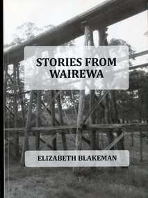
Book, Stories From Wairewa, 2017
This book is a social history collected orally and from the private records of residents of the Wairewa Valley, Victoria, Australia. It includes a brief history of the old primary school. Appended is a performance piece 'Waltz for Wairewa", a dialogue with poems and songs. It was sponsored by the Hospital Creek Bush Band and Dance Group. The book was partly the result of two song writing courses, one run on-line for six weeksby Sheffield University, U.K., and another year-long course at U3A in Lakes Entrance, East Gippsland. The bridge pictured on the front cover is O'Grady's railway bridge which was severely damaged in the bushfires of January 2020.This item is a useful reference on the history of the Wairewa Valley, East Gippsland.A soft covered book, titled "Stories From Wairewa". On the front cover is a tall wooden rail bridge. the book contains stories, photographs, scanned documents, shet music, drawings and poetry. book-wairewa blakeman-elizabeth school-wairewa -
 Darebin Parklands Association
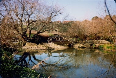
Clifton Bridge, 1979-1980
The bridge was designed and constucted by Sidney Clifton, an engineer who lived in a house neighbouring the parklands.Colour photograph. The wooden frame of the Clifton Bridge which the concrete was poured in to set. This item and all other Darebin Parklands Association archival material is now held by State Library Victoria (Accession No: YMS 13746). Please contact State Library Victoria if access is required. -
 Darebin Parklands Association
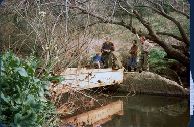
Installing Clifton Bridge, 1979-1980
The bridge was designed and constucted by Sidney Clifton, an engineer who lived in a house neighbouring the parklands.Colour photograph. The wooden frame used to set the concrete section of Clifton Bridge. This item and all other Darebin Parklands Association archival material is now held by State Library Victoria (Accession No: YMS 13746). Please contact State Library Victoria if access is required. -
 Darebin Parklands Association
Clifton Bridge, 1979-1980
The bridge was designed and constucted by Sidney Clifton, an engineer who lived in a house neighbouring the parklands.Colour photograph. The wooden frame of the Clifton Bridge which the concrete was poured in to set. This item and all other Darebin Parklands Association archival material is now held by State Library Victoria (Accession No: YMS 13746). Please contact State Library Victoria if access is required. -
Port Melbourne Historical & Preservation Society
Photograph - Yarra River, Ron Laing, 1990s
Part of Ron Laing's collection of photographs recording Port Melbourne over a thirteen year period. Donated to the PMH&PS by the photographer. nb Includes photographs of Victoria Dock in the period of time after the commercial shipping had gone but before the start of the proposed high-rises. The Bolte Bridge which caused this closure of Victoria Dock, North and South Wharves is covered in photos 1319.01-.35.A set of 47 colour photogaphs of the Yarra River at various locations from the old Sandridge Railway Bridge westward to the power house at Newportyarra river, built environment, transport - shipping, ron laing -
 Glen Eira Historical Society
Album - Album page, Hotham Street, Circa 1972
This photograph is part of the Caulfield Historical Album 1972. This album was created in approximately 1972 as part of a project by the Caulfield Historical Society to assist in identifying buildings worthy of preservation. The album is related to a Survey the Caulfield Historical Society developed in collaboration with the National Trust of Australia (Victoria) and Caulfield City Council to identify historic buildings within the City of Caulfield that warranted the protection of a National Trust Classification. Principal photographer thought to be Trevor Hart, member of Caulfield Historical Society. Most photographs were taken between 1966-1972 with a small number of photographs being older and from unknown sources. All photographs are black and white except where stated, with 386 photographs over 198 pages.Victorian Heritage Database - Hotham Street Road Overbridge HO116 Heritage Overlay - City of Glen Eira https://vhd.heritagecouncil.vic.gov.au/places/43557 (as of 04/07/2021) The Hotham Street road overbridge is located on the Sandringham railway line between Ripponlea and Elsternwick railway stations. It is presumed to have been built by contractors Sharp and Campbell who signed a contract on 25th . November, 1881 to construct a second line of railway between Windsor and Elsternwick. This contract was completed during 1882 and the bridge may have been designed in the year when Robert Watson took over from William Elsdon as engineer in chief for the Victorian railways. It is historically, aesthetically and technically significant. It is historically significant (Criterion A) to the extent that it demonstrates the standards of construction adopted by the Victorian Railways Department when it rebuilt the lines acquired from the private railway companies, (compare the Geelong and Melbourne Railway Co's line from Newport to Geelong, acquired in 1860). It is aesthetically significant (Criterion E) as an intact nineteenth century structure of its type, many similar girder bridges having been renewed with concrete girders in recent years. The bluestone abutments demonstrate high standards of stone masonry and are representative of Departmental work of the period. This bridge forms one of a group of historic structures on the railway to Brighton Beach and therefore contributes to the line's cultural importance as a whole. The survival of the riveted iron girders with their bellied angle iron struts is important since these elements are representative of the civil engineering practices of the Victorian Railways at the time and constitute the technical significance (Criterion F) of the structure.Page 96 of Photograph Album with three photographs (one portrait and two landscape) from Hotham Street - two external views of one house and a railway bridge.Handwritten: Hotham Street [top right] / 112 HOTHAM ST [under top left photo] / BRIDGE OVER SANDRINGHAM RAILWAY [under top right photo] / 112 HOTHAM ST CNR MELBY AVE [under bottom left photo] / 96 [bottom right]trevor hart, elsternwick, hotham street, caulfield, houses, brick, bay windows, verandahs, railway bridges, tunnels, gardens, bluestone, civil engineering, victorian railways, sharp and campbell, contractors -
 Ballarat Tramway Museum
Photograph - Digital image, Wal Jack, 3/07/1955 12:00:00 AM
Yields information the reconstruction of the Canadian Creek Bridge in 1955.Digital image from the Wal Jack Ballarat Album of No. 31 at Canadian Creek bridge in Barkly St, Mt Pleasant during the reconstruction of the bridge. Photo dated 3-7-55 and shows the reconstruction work in progress. Tram was isolated to enable the service in Barkly St during the reconstruction of the Canadian Creek bridge during June-July 1955, see Reg Item 5155 as well and 5301, 5302 and 5305 and 7735. See image i2 for rear of photograph. See image i3 for hi res scan of print. See image i4 for hi res scan of negativeon rear of photo in ink, "SEC Ballarat, No. 31 in Barkly St west of creek during rebuilding of bridge, trams weren't able to cross. Ballarat June 1955" In the top right hand corner is the W. Jack stamp but no negative number. In top left hand corner "3rd July 1955".trams, tramways, mt pleasant, barkly st, canadian creek, bridges, tram 31 -
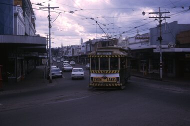 Ballarat Tramway Museum
Slide - 35mm slide/s, Peter Moses, 21/08/1971 12:00:00 AM
Photo of SEC Ballarat No. 11 turning from Main St into Bridge St while running on the ARHS/TMSV special trams prior to closure. Tram 11 has a Twin Lakes sign on back of tram and showing destination of "Sebastopol". Kodak cardboard mount slide, taken by Peter Moses 21 August 1971.On the rear of the slides in blue ink "Ballarat / From Main St. into Bridge St." and "P. Moses" in the top left hand corner in black ink.tramways, trams, bridge st, main st, special trams, tram 11 -
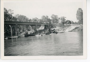 Port of Echuca
Black and white photograph, 1971
This is a photograph showing the P.S. Alexander Arbuthnot about to be removed from the water to be transported to Shepparton for restoration. The Alexander Arbuthnot was pulled off the bottom of the river at Yielma in July 1972 and taken to Shepparton via Barmah in January 1973.This photograph is significant as it shows the P.S Alexander Arbuthnot about to come out of the river, to be fully restored.A black and white photograph 13 cms X 9 cms of the P.S Alexander Arbuthnot under the Barmah Bridge, prior to being taken out of the river and taken to Shepparton.Written on the back of the photo are the following words. "Alexander Arbuthnot being moved into position under the Barmah Bridge prior to removal from the water and transported to Shepparton for restoration 1971 - 1973. The paddle screamer was previously sunk near the Victorian bank. At Newmans property at Yielma." paddle steamers, ralton, greg, shepparton, p.s alexander arbuthnot, international village shepparton, yielma -
 Darebin Parklands Association
Installing Clifton Bridge, 1979-1980
The bridge was designed and constucted by Sidney Clifton (pictured), an engineer who lived in a house neighbouring the parklands.Colour photograph. The wooden frame and handrails of the bridge are erected ready for the concrete to be poured in. This item and all other Darebin Parklands Association archival material is now held by State Library Victoria (Accession No: YMS 13746). Please contact State Library Victoria if access is required. -
 Sunbury Family History and Heritage Society Inc.
Photograph, c 1910
The photograph was taken from the iron bridge on the Rupertswood Estate. The tower of the Rupertswood Mansion can be seen in the distance. The Eadie family were business people and millers in Sunbury.A post card featuring a dark sepia image of a creek with a large house in the distance. There is a hand written message on the back.Written on the back: Dear old boy Many happy returns of the 8th. I . . . . . . . . . . . . making the . . . .Yours ever Will. Iron bridge at Rupertswood. Mr Hal Eadie Dannevirke NZ.rupertswood mansion, jacksons creek -
 Kiewa Valley Historical Society
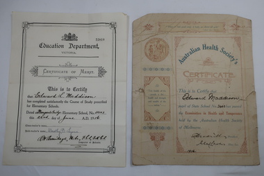
Papers - Certificates - Edward Maddison
The Australian Health Society was formed in Melbourne in 1875 at the instigation of Unitarian Minister MarthaTurner. It promoted hygiene and comprised of doctors, prominent citizens and politicians. It targeted poorer districts and women. Schools were pressured to place health education on the curriculum. Society stalwarts made an annual examination in state schools. Mongan's Bridge No. 3403 opened in 1902. It was located beside the Kiewa river and operated part-time with nearby schools on occasions as well as full time. As numbers fluctuated it was also closed on occasions and then re-opened.Edward Maddison's family were farmers in the Kiewa Valley and the children attended the local school.Two certificates belonging to Edward Maddison 1. 1916 Pupil of State School No 3403 (Mongan's Bridge) - passed the Examination in Health and Temperance held by the Australian Health Society of Melbourne 2. 1916 Completed satisfactorily the Course of Study prescribed for Elementary Schools.- Mongan's Bridge Elementary School No. 3403edward maddison, australian health society, mongan's bridge school -
 Eltham District Historical Society Inc
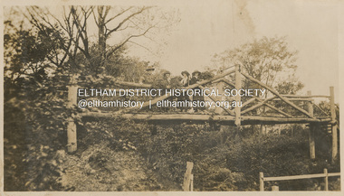
Photograph, "Curry, Byrne, McGeachy & self on rustic bridge, Eltham", 22 Oct 1919
The old Diamond Street bridge in Eltham had a raised section seen here and a lower section, the railings of which can just be seen. The upper pedestrian crossing provided continual access for foot traffic during times of flood. This photo is part of the Alice Broadhurst collection held by Yarra Plenty Regional Library, a series of 12 photo albums compiled by Alice Broadhurst (1896-1981), initially while working as a Voluntary Aid Detachment nurse with the Australian Red Cross at the Mont Park Military Hospital (No. 16 AGH) and subsequently as a nurse at the Royal Melbourne and Royal Women’s hospitals alongside many pioneering doctors of their fields. This photo depicts an outing with fellow VAD nurses McGeachy and Byrne and two patients of Mont Park, Curry and Caffery to Eltham in spring 1919 Digital file"Curry, Byrne, McGeachy & self on rustic bridge, Eltham, Oct 22, 1919"eltham, diamond creek, diamond street bridge, alice elizabeth broadhurst, byrne, caffery, curry, mcgeachy, nursing staff, mont park, 16 agh -
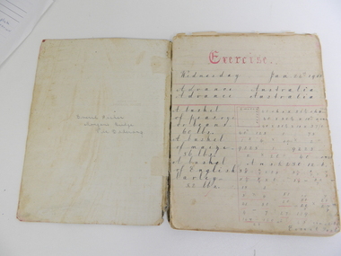 Kiewa Valley Historical Society
Book - Student's Exercise Book, Exercise book used at school, Used in 1912
Educational: handwriting of the time. Also Maths, Dictation. Everil Fisher's family lived at Mongans Bridge in the Kiewa ValleyHistorical: comparison of book work, hand writing, dictation and maths in 1912 to current times. Provenance: Everil Fisher's family lived at Mongans Bridge. Her family donated many significant items to KVHS showing an interest in history.Plain black hard covered exercise book with handwriting, mathematical, and dictation exercises. Pages are blue lined. Cotton thread spine binding. Inside front cover: Everil Fisher / Mongans Bridge / Via Dederang Exercises dated Jan. 24th 1912 to 29th Oct. 1912 Corrections and comments in red. Written work in greyish ink.education. handwriting. mathematics. dictation. everil fisher. mongans bridge -
 Stawell Historical Society Inc
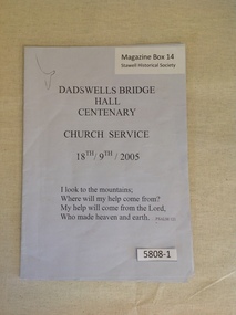
Book, Dadswells Bridge Hall Centenary Church Service 18th/19th/2005, 2005
Order of service for the Dadswells Bridge Hall centenary, Church Service.Pale Blue/Grey Paper with black PrintDadswell Bridge Hall Centenary Church Service 18th - 19th 2005 I Look to the mountains; Where will my help come from? My Help will come from the Lord, Who made heaven and earth..... Psalm 121stawell religion -
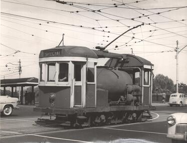 Ballarat Tramway Museum
Photograph - Black & White Photograph/s, Jim Seletto, 1955
Yields information about one of the MMTB scrubbers, No. 8, trams crossing Princes Bridge during 1955. This tram is now at the Museum.Black and White photograph of MMTB Scrubber tram No. 8 at the intersection of Batman Ave and Swanston St 1955, after coming off Princes Bridge. Has the Batman Ave terminus buildings in the background. Photo J. Seletto. Copy 2 - printed on postcard back.On rear in ink "Number 8 MMTB At Princes Bridge 1955" and "D Print Photo J. Seletto" and hand date stamp "17 Jan 1962" - this could be the print date.trams, tramways, scrubber tram, princes bridge, swanston st, batman ave, work trams, tram 8 -
Port Melbourne Historical & Preservation Society
Pamphlet - Proposing West Gate Bridge, The Lower Yarra Bridge, 1968
Found in Lois Daley's father's technical manual''The Lower Yarra Bridge': brochure proposing West Gate Bridge, 1968engineering - bridges, west gate bridge, lower yarra crossing authority -
 Whitehorse Historical Society Inc.
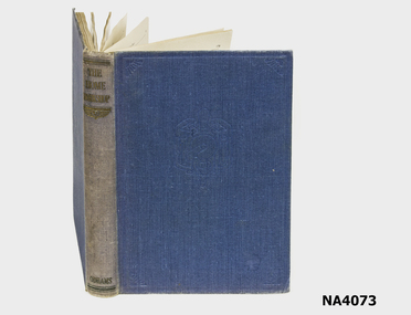
Book - Book 'The Home Workshop', 1948
Blue cloth cover. faded blue spine (linen). Paper 384 pages.J.S.Edington - Murray Bridge.books, reference -
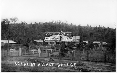 Eltham District Historical Society Inc
Photograph, Scene at Hurstbridge, 1914
Postcard view of "Allwood", Hurstbridge, built about 1894 as the second home of the pioneer Hurst family. Frances Hurst married William Gray in 1897. The Grey family would later live in the house. Grey operated Allwood Nurseries.This photo forms part of a collection of photographs gathered by the Shire of Eltham for their centenary project book, "Pioneers and Painters: 100 years of the Shire of Eltham" by Alan Marshall (1971). The collection of over 500 images is held in partnership between Eltham District Historical Society and Yarra Plenty Regional Library (Eltham Library) and is now formally known as 'The Shire of Eltham Pioneers Photograph Collection.' It is significant in being the first community sourced collection representing the places and people of the Shire's first one hundred years.Digital imageScene at Hurst Bridgesepp, shire of eltham pioneers photograph collection, hurstbridge, gray homestead, william george gray, allwood, postcard -
![Photograph - Construction of the F19 [Eastern Freeway], Ron Setford, August 1977](/media/collectors/550653872162f11fb04854aa/items/6808c7a6025de50d1e73c00d/item-media/6808c7d2025de50d1e73c40e/item-fit-380x285.jpg) Kew Historical Society Inc
Kew Historical Society IncPhotograph - Construction of the F19 [Eastern Freeway], Ron Setford, August 1977
Ron Setford and his wife Grace Setford lived in Tanner Avenue, East Kew, from c.1946 to c.1995. A keen photographer, he recorded the changing face of Kew over a 20 year period. Apart from 30 photographs of built structures and places in Kew dating from 1960 and 1961, 145 of his 35mm colour slides chronicle the development of the F19 (later renamed Eastern) Freeway through the Yarra Valley in Kew over a five year period from c.1972 to c.1977. This important collection was donated to the Society by his granddaughter in 2025.This collection of 175 35mm slides is of local and statewide significance, owing to its subject matter, particularly the major development of road transport infrastructure during the 1970s with the construction of the Eastern Freeway. The photographer also took care to annotate and date most of his slides which enable the researcher to pinpoint temporal and spatial locations."Temporary Bailey Bridge"ron setford, eastern freeway, f19 freeway -
![Photograph - Construction of the F19 [Eastern Freeway], Ron Setford, December 1977](/media/collectors/550653872162f11fb04854aa/items/683bdb0869688f11138e9737/item-media/683bdb6769688f11138e9989/item-fit-380x285.jpg) Kew Historical Society Inc
Kew Historical Society IncPhotograph - Construction of the F19 [Eastern Freeway], Ron Setford, December 1977
Ron Setford and his wife Grace Setford lived in Tanner Avenue, East Kew, from c.1946 to c.1995. A keen photographer, he recorded the changing face of Kew over a 20 year period. Apart from 30 photographs of built structures and places in Kew dating from 1960 and 1961, 145 of his 35mm colour slides chronicle the development of the F19 (later renamed Eastern) Freeway through the Yarra Valley in Kew over a five year period from c.1972 to c.1977. This important collection was donated to the Society by his granddaughter in 2025.This collection of 175 35mm slides is of local and statewide significance, owing to its subject matter, particularly the major development of road transport infrastructure during the 1970s with the construction of the Eastern Freeway. The photographer also took care to annotate and date most of his slides which enable the researcher to pinpoint temporal and spatial locations."Chandler Hwy Bridge"ron setford, eastern freeway, f19 freeway -
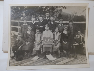 Kiewa Valley Historical Society
Photo - Mongan's Bridge School (no date)
Mongan's Bridge opened on 1st March 1902. By 1906 there were 20 students. In 1907 the school worked half time with Upper Gundowring School. It continued to struggle with numbers until it became full time in January 1919, closed in September in 1923. It reopened in 1932 closed 1940, reopened in 1943 and closed 1964. Ref. Vision and Realisation Volume 3 Page Page 1006Mongan's Bridge was a small school in the Kiewa Valley. The school struggled to stay open due to the number of enrolments, and at one stage, due to the condition of the building. The clothes of the students and the dates that it opened may assist in dating the photo.Black and white photo of 14 people with blackboard indicating it is Mongan's Bridge School. The photo is mounted on cardboard. The students and teacher names are written on the back.On the Back: S. Baker's address written on the bottom left-hand corner.mongan's bridge school, school photo