Showing 7666 items
matching city centre
-
 Kiewa Valley Historical Society
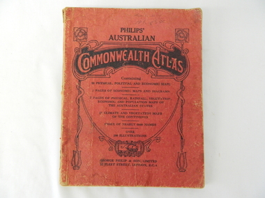
Atlas Australian Commonwealth, Philips' Australian Commonwealth Atlas, 1944
This atlas, printed in 1944, details not only the geographic and political boundaries of the world as it was at that time but also the snap shot of life of the time. This snap shot in time covers the major Australian cities, the major farming, grazing, industrial and sporting/recreational activities. Also there are snap shots of similar activities from other global areas. The period also covered World War II, detailed by a photo of "shell making", munitions, required by Australian soldiers. The great political and territorial changes made as a result of World War II can be clearly identified for example , Israel (the Jewish homeland). The various prewar colonies of major European nations.This atlas was used by children of a Kiewa Valley family and shows the value and the general educational exposure that these children had at this time. The rural setting and within the backdrop of a world war did not severely alter the life style of children in this region. The "news reels" shown in cinemas of cities and larger towns were the only visual realisations of major events of global significance available to these children. The information provided by this atlas allowed students to glimpse at what the "outside world" was. The majority of these students would possibly never see these regions for themselves. The great communication facilities of the late 1900s and beyond, was still only science fiction.This atlas has a thick (350 g/m) red cardboard cover with bold black lettering and shading. The cover is set out within a shield like frame. The shield is held up by two square markings, each with a four part circular pattern and a cord entwining two pendulum structures ending with a bowl figure at the bottom. There is a semi circular form enclosing a printed book contents list. The inside cover has the atlas title and contents and the publisher details. The atlas contain 56 pages of world and Australian maps, vegetation and rainfall maps. Within this atlas there are 27 double sided pages of black and white photographs depicting life styles, buildings, landscapes and prominent and significant to Australia males from 1652 to 1944. The pages are of approximately 200 g/m and have the yellow aged appearance.On front cover "Philips' Australian COMMONWEALTH ATLAS" and underneath "Containing" underneath "60 PHYSICAL, POLITICAL AND ECONOMIC MAPS". Publisher George Philip & Son, Limited 32 Fleet Street, London E.C. 4. Inside cover are: written, in freehand and in ink the following names and dates; "J.Muller Form V 1945", "L L Muller Form IV 1946", "N.J. Muller Form I + II + III 1948 +49 + 50" and "D Muller Form I 1949". also handwritten and in pencil is "Peter Leslie". On the last page is a small freehand sketch of Australia in biro.1940s school curriculum, rural education, 1940s atlas, australian atlas -
 Kiewa Valley Historical Society
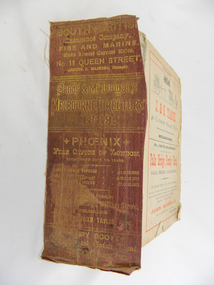
Book - Reference Melbourne Directory, Melbourne and Suburban Directory for 1889, Circa 1889
This Directory of 1889 covers the location of Melbourne based trade and professional offices by street and in Alphabetical order. It covers all of Melbourne and its suburbs. It also covers government and official, ecclesiastic, legal, municipal and miscellaneous information. The directory details a cross section of a developing city with a splattering of advertisements opening up an in depth look of all aspects of living in the late 1800s. It is interesting to see that all the advertisements do not have any telecommunication numbers listed (personal shoppers or mail orders only). This was a period of high moral standing within the community and hotels advertised rooms " suites of rooms for families and single rooms for Ladies and Gentlemen" also "electric bells throughout the house. Telephone, night porter and hot and cold baths."This directory would be used by the majority of families and businesses working and living within the Kiewa Valley and the surrounding area. Melbourne was the only place where every aspect of living requirement was catered for. Although the delivery of services and goods were not at a high rate, certain items or transactions would require a visit to "the big smoke". Business information are listed both by suburb and alphabetically. There is also a section for British and Foreign Trade. This directory covered nearly everything to do with commerce, an example pay days for principle firms. Greater evolution of trade locations started to balloon out after the mid 1950's. Increased populations and greater levels of communication and safe fast transport facilities permitted greater devolution of commercial enterprises into rural communities, such as the Kiewa Valley.This directory has no front or back cover and is held together by its cloth spine. It contains over 1300 pages, however there may be some pages missing front and back of the directory which would have contained advertisements of some unknown shops. All the sides of this directory (except the spine) have advertisements and content information stamped on. The spine cover has been placed in the directory until further conservation work is carried out. It has gold coloured printing and in the central section, a gold coloured background with the words "Sands & McDougall's Melbourne Directory 1889." The spine has three adverts on the spine.On the spine in gold colour "South * British insurance Company Fire and Marine. Risks Lowest Current Rates No. 11 Queen Street, Arthur J Masters, Manager" and half way down " *Phoenix* Fire Office of London established over 100 years Annual Income exceeds (pound sign) 1,000,000" underneath "Losses Paid Over (pound sign) 16,000,000" underneath "Reserve Fund Exceeds (pound sign) 1,000,000" underneath "9 Market Buildings William Street, Melbourne " underneath " R. Manfield Taylor, Agent" and at the bottom section" Henry Scott Auctioneer and Estate Agent 49 Bridport St., Albert Park" stamped on the bottom side across the page endings "The Wonderful Wertheim Sewing Machines Swanston Street opposite Town Hall", stamped on the top side across the page endings " The Sweet Hapsburg Pianos & Organs Swanston Street Opposite Town Hall"state government listings, names and location of early melbourne population business names, 1889 members of the victorian executive council -
 Kiewa Valley Historical Society
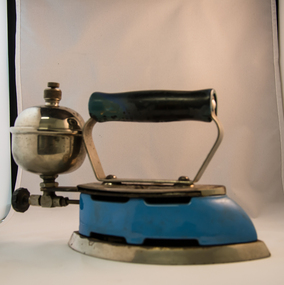
Iron Hand Kerosene, mid to late 1900s
The 1950's saw a revolution in small appliances for use in the average household. This hand held self heating(kerosene) iron was introduced as a time saving and more convenient iron for pressing clothes and other cloth fabrics. It replaced irons needing a separate fire source to heat the ironing plate. These irons continued to be in service, even when electricity was available in cities and larger rural towns (domestic electric steam irons were invented in 1938). This item was used before and during the electricity supplies available from the Kiewa Hydro Electricity Scheme. These irons remained in use within regional rural areas that had limited or unreliable electrical reticulation.In the 1950s and later the Kiewa Valley was still a relatively isolated region which was home to rural properties and small settlements. The availability of electricity and or the financial means to afford new types of electric hand irons ensured that older and sometimes less efficient ironing remained for an extended period covering the 1960s to 1970s. Kerosene products, such as this kerosene iron was a cheaper method for farm based domestic and other rural activities requiring a heat source. The use of kerosene as a heat/light source was able to be supplied in bulk and able to be used when floods severed vital roads into this region. The supply of electricity was in summer time subject to interruption from bush fire damaged wooden poles carrying the electrical cables. Self sufficiency by rural populations was the backbone of survival and the ability to store energy sources "on the farm" was a prerequisite of isolated regions, such as the Kiewa Valley, circa 1950s.This Coleman kerosene iron has a solid steel chrome plated(press) base with a painted (blue) wooden handle. The handle is stud fastened onto an oblong shaped rolled steel handle frame and screwed (two screws) onto the base plate. Both the heating plate and the top securing plate are shaped similar to a river boat. The main housing enclosing the heating element is enamel coated(blue in colour) steel and has a half hole for lighting the kerosene at the rear end. Behind the handle and protruding upwards is a stainless steel fully enclosed container (bowl shaped) for the main supply of kerosene to the burner or generator(enclosed within the main body of the iron. The bowl has an air valve and inlet for pressurised air intake (hand pump) On the bottom rear of the fuel bowl there is a screw regulated fuel pump. The fuel heated base plate provides the heat for this advertised "self heating iron(instant lighting). See KVHS 0347B- Instruction sheet; KVHS 0347C- Wrench; and KVHS 0347D Fuel can.Stamped on the base plate of the handle, front region "COLEMAN LAMP & STOVE CO." below this "WICHITA KAN" below this"TORONTO CAN". In the middle of the handle base and in larger print "COLEMAN Instant-Lite" At the rear location in large print "MODEL 4" in smaller print below "MADE IN U.S.A." below this "PAT#1718473"household appliances, alternative non electrical ironing appliances, domestic appliances, kerosene appliances -
 Kiewa Valley Historical Society
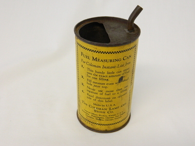
Can Fuel Measuring, circa 1950
The 1950's saw a revolution in small appliances for use in the average household. The hand held self heating(kerosene) iron for which this filling can was provided ,was introduced as a time saving and more convenient iron for pressing clothes and other cloth fabrics. It replaced irons needing an external fire source to heat the ironing plate. These irons continued to be in service, even when electricity was available in cities and larger rural towns. This item was used before and during the electricity supplies available from the Kiewa Hydro Electricity Scheme. These irons remained in use within regional rural areas that had limited or unreliable electrical reticulation and the ability to service them from this filling can was an essential part.n the 1950s and later the Kiewa Valley was still a relatively isolated region which was home to rural properties and small settlements. The availability of electricity and or the financial means to afford new types of electric hand irons ensured that older and sometimes less efficient ironing appliances remained for an extended period covering the 1960s to 1970s. Kerosene products, such as the kerosene self heating (KVHS 0347A) iron and this kerosene filling item, was a cheaper method for farm based domestic and other rural activities requiring a heat source. The use of kerosene as a heat/light source was able to be supplied in bulk and able to be used when floods severed vital roads into this region. The supply of electricity was in summer time subject to interruption from bush fire damaged wooden poles carrying the electrical cables. Self sufficiency by rural populations was the backbone of survival and the ability to store energy sources "on the farm" was a prerequisite of isolated regions, such as the Kiewa Valley, circa 1950s.This specially spout fitted can was provided with the Coleman self heating kerosene iron (see KVHS 0347A). On one side of the half enclosed top of the can there is a small spout(for poring the appropriate liquid into the egg shaped fount container) at the rear end of the hand iron. The can is made from tin. See KVHS 0347B- Instruction sheet; KVHS 0347C- Wrench.On one side of the can in black print on yellow background is "FUEL MEASURING CAN" underneath is "For Coleman Instant-Lite Iron" underneath are four numbered paragraphs detailing the use of this can. Below this is the name and places of manufacture. On the other side of the can is printed "BE SURE" with filling and maintenance instructionskerosene can, ironing, domestic appliances, household appliances -
 Eltham District Historical Society Inc
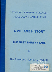
Book, Citymission Retirement Village - Judge Book Village, Eltham: A Village History; the first thirty years / The Reverend Norman C. Pearce, 1986
CityMission Retirement Village, also known as Eltham Retirement Centre, also formerly known as Judge Book Memorial Village, was officially opened on Sunday 28 October 1956. This history documents the first thirty years through to 1986. Founded by the Melbourne City Mission, the significant early history of the "village for the aged" is documented including the various challenges faced including ongoing expansions and building develoment needs and impacts of flooding from the nearby Diamond Creek. It mentions some people associated with the organisation with reference to the Eltham Auxillary which was a group of Eltham residents formed to support the organisation and its residents through activity and fundraising efforts.Softcover; 60p.judge book village, retirement village, melbourne citymission, eltham, aged care, seniors, social service, older people, housing -
 Eltham District Historical Society Inc
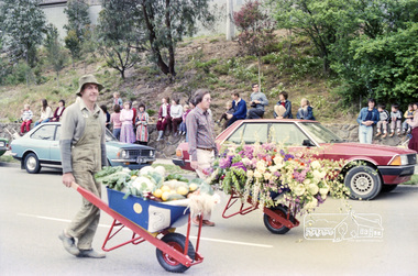
Photograph, Eltham Festival Parade, 16 October 1982, 1982
Roll of negatives of the Eltham Festival Parade as it progresses along Main Road past the Catholic Church heading towards Bridge Street. Floats included the Tasmanian Wilderness Society with the Save the Franklin River campaign, and Diamond Valley Railway celebrating 21 years of passenger service as well as the Victorian Police Marching Band. A well known Eltham identity, Jock Read was asked to lead the Eltham Pony Club contingent that year and the roll includes several shots of Jock on his horse, Lofty who was approximately ten years of age, his colour was still classed as a steel grey at the time before he went "white" quite a few years later. 1982: 16-17 October. “Pioneers of Eltham” and tractor (rain) Neswletter No. 27, November 1982 Although our parade entry did not win a prize this year, it was considered highly successful from a participation point of view. Despite some uncertainty as to just who was coming, members and friends kept appearing at the assembly area. As in the past years our friends from the Victorian Folk Music Club brought their instruments along and really added to the occasion. This year we concentrated on a rural theme with a tractor/trailer combination. Thanks to Peter Bassett-Smith for the tractor, Joh Ebeli for the decorations and friendly trailer owner Dennis McKay. Unfortunately the closing stages of the parade were marred by heavy rain. We just finished as the rain started but members scattered very quickly. This has prompted the suggestion for future parades that we have a tent or other suitable venue for members to gather after the event. This is worth following up. The cold driving rain provided a special problem for Peter in driving his tractor home to Kangaroo Ground. Have you ever had to choose between standing up to warm your hands on the exhaust and having your tractor seat flooded? Certificate, Festival Parade Award, Rotary Club of Eltham, Eighth Eltham Community Festival 1982. Presented to the Shire of Eltham Historical Society for the most effort by "locals"Roll of 35mm colour negative film, 24 shotsKodak Safety Film 5035eltham festival, catholic church, diamond valley railway, eltham, eltham district historical society, eltham parade, festivals, eltham fire brigade, eltham horse and pony club, jock read, learning co-op primary school, eltham living and learning centre, lofty (horse), main road, marching band, montmorency scouts, parade, parade floats, peter bassett-smith, research pre-school, roller city, shire of eltham historical society, victorian police -
 Eltham District Historical Society Inc
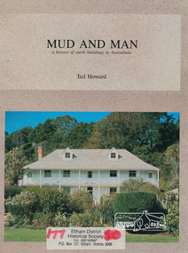
Book, Earthbuild, Mud and Man: a history of earth buildings in Australia by Ted Howard, 1992
Includes references to local sites Bear's Castle, Yan Yean (City of Whitlesea), mud brick houses in Eltham, including at Montsalvat and Eltham Community Centre, Smith's Gully, Plenty Baptist Church and Warrandyte. Includes chapter on Alistair Knox. The author's own home appears in the book on page 100. It was situated at Batman Road, Eltham next to the manse and church opposite Stanley Avenue. It was demolished for unit development June 2004 after the author's death in 2003. A significant and oft cited history of the mud brick earth construction style of architecture which includes a number of examples within the Shire of Nillumbik, known to be a site of the environmental earth building movement following WW2.198 p. : ill. (some col.), maps ISBN 0646069624earth construction, mud bricks, pise, domestic architecture -
 Eltham District Historical Society Inc
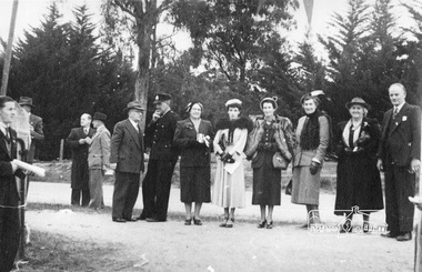
Photograph, Peter Bassett-Smith, Cermony for turning of the first sod, Eltham War Memorial Infant Welfare Centre Building, 18 Jul. 1950
Major Frank D. Stevens, RSL President and school boy Albert Feldbauer (youngest child of the children of the soldier fathers attending a school in the district) at the ceremony of turning the first sod for the Eltham War Memorial Infant Welfare Centre Building. Major Frank Stevens was later the Scout Commissioner of Heidelberg City Scout Groups from Fairfield railway gates to the intersection of Main Road at Hurstbridge.Eight original prints (21.5 x 18 cm - plus three duplicated) and one 10 x 15 cm colour print reproduction from a negative taken of original printalbert feldbauer, ceremonies, eltham, eltham war memorial building, fred griffiths, cr. fred squire, main road, major frank stevens, memorials, mrs dave lyon, mrs rains, war memorials, eltham infant welfare centre -
 Warrnambool and District Historical Society Inc.
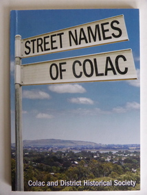
Book, Streets of Colac, 2008
This is a book giving information on the streets of Colac and the origins of the names. Colac is a city 150 kilometres south west of Melbourne and is a commercial centre for a major agricultural area. It is situated near the 3rd largest volcanic plain in the world and European settlement began in 1837. The book was commenced by Ian McIntosh in the 1970s and in 2005 the Colac and District Historical Society took on the project again with the major editors being Ida and Andrew McIntosh. This book is of interest, particularly those in the Western District of Victoria, as it contains information on Colac streets, many of which were named after pioneers of the district. The book will be useful for research. This is a soft cover book of 60 pages. The cover has a blue background and features a colour photograph (mainly in green, blue and white tonings) of a panorama of the Colac district. The photograph extends over the front and back covers. The book contains the names and name origins of Colac streets in alphabetical order and many black and white photographs. The pages have a glued binding. Front Cover: ‘Street Names of Colac’ ‘Colac and District Historical Society’ history of colac, colac and district historical society, street names of colac, ian mcintosh -
 Warrnambool and District Historical Society Inc.
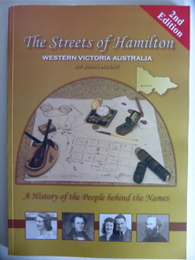
Book, Streets of Hamilton, 2007 (revised and reprinted 2009)
This is a book providing information on the streets of Hamilton, Victoria and the origin of the names. Hamilton is a city in Western Victoria at the intersection of the Glenelg Highway and the Henty Highway. European settlement began with the arrival of pastoralists following the 1836 explorations of Major Thomas Mitchell. The Wedge family in 1839 had the property ‘The Grange’ which covered the site of Hamilton today. The town was gazetted in 1851 and named after a place in Scotland. Hamilton Victoria is the centre of a sheep-grazing and agricultural district. The book won an award in the 2008 Victorian Community History Awards. This book is of interest as it gives information on the Hamilton streets and the origin of their names. The history of Hamilton is of particular interest to those also living in the Western District. The book will be a useful research tool. This is a soft cover book of 174 pages. The back cover has a white background with black and white photographs of five local Hamilton people. The front cover has a yellow and brown background with black and white photographs of five local Hamilton people, an outline of a map of Victoria and a photograph of a map of the Hamilton area with some artefacts placed on the map. The book contains an Introduction, a Preface, a Foreword, an Early Days Overview, a list of Contents, a list of the streets in alphabetical order with information on the origin of the names, two Appendices and an Index. The book has many black and white photographs and sketches. Front Cover: ‘2nd Edition’ ‘The Streets of Hamilton’ ‘Western Victoria Australia’ ‘By John McKay’ ‘A History of the People behind the Names’hamilton, victoria, john mckay, street names of hamilton, warrnambool -
 Warrnambool and District Historical Society Inc.
Book, The happy mother & child by Issi Younger Ross, 1940
This book has been written by Dr Isabella Younger Ross. She was born in Warrnambool to John and Henrietta Younger. The Younger family business was a large department store in Liebig Street and it operated for over 60 years. Isabella (Isie)Younger was educated at Hohenlohe College, Warrnambool, studied medicine at Melbourne University and graduated from the University of Glasgow. She worked for some time in Britain, married John Ross in 1916 and returned to Melbourne in 1917. Here she embarked on a medical career, focusing on child health and mothercraft, an area in which she specialized for 40 years. She was the catalyst for the formation of Baby Health Centres in Victoria and was awarded an O.B.E. for her work in infant welfare. She died in 1956.This is a most important book as it is a key early text on infant welfare and it has been written by Dr Isabella Ross who was born in Warrnambool and received her primary and secondary education in that city. She is very important in the history of infant welfare education in Victoria. The book also contains the signature of the author. This is a hard cover book of 184 pages. The cover is light brown/orange with dark brown print on the front cover and on the spine. The book has an Introduction, eleven chapters of text and an Index. There are several black and white sketches scattered throughout the text. The signature of the author in pencil is on the first page. The cover is slightly scuffed.‘Isie Younger Ross’ younger family, warrnambool, younger stores, warrnambool, infant health education in victoria, isabella younger ross, history of warrnambool -
 Victoria Police Museum
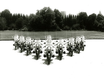
Photograph (police motorcycle)
Nine Honda 900s in a V formation with one back in the centre of the V, at the rear of formation, and the city skyline in the background. Circa 1981police vehicles; wireless patrol; motor transport branch; motor transport section; motor cycle patrol; police motorcycles; honda 900 motorcycle -
 Warrnambool and District Historical Society Inc.
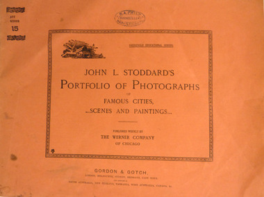
Booklet, Printed in USA, Portfolio of Photographs of Famous Cities, 1893
In a time when travel to distant parts of the world were difficult. Magazines such as these, offered people the opportunity to see the sights of the World. The link to Warrnambool, with this publication is the R.A. Philp stamp on the front cover. R. A. Philp was a bookseller who operated his business in Timor St opposite the Post Office.Soft card, light brown cover, with black text. Inside black rectangular border is the title “John L. Stoddard’s Portfolio of Photographs of Famous Cities scenes and Paintings.” In smaller text “Published weekly by the Werner Company of Chicago. ”Art Series 10 on top left corner. Inside are 16 pages of Black and white photos of scenes from around the world, with explanatory text underneath each photo. Back cover has list of contents of Series 11. Purple stamp, R.A. Philp, bookseller Warrnambool, in centre top. Gordon and Gotch, London, Melbourne, Sydney, Brisbane, Capetown.warrnambool, philp, booksellers., stoddard -
 Warrnambool and District Historical Society Inc.
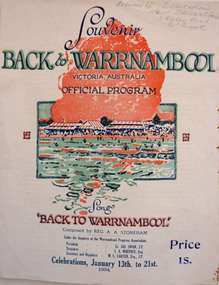
Programme - Back to Warrnambool Souvenir program, 1934
This program provides information for the week of festivities in 1934The Back to celebrations were an important event on the social calendar and this program gives an insight into the kinds of events which were prevalent during the early to mid 20th century. White cover printed in dark blue with red and green accents. Picture of Warrnambool main beach centre front. Back cover is in black and white, Black text at the top reads Warrnambool the Capital City of the West—The city Beautiful. Underneath is a large photo of the Hopkins Falls. The inside four pages contain a brief history of the city, the program for the week and words of the song Back to Warrnambool. A map is on the inside back cover.Particulars supplied by the W’bool Progress Association.warrnambool, back to warrnambool, 1934 official program, reg. a. a. stoneham., reginald alberto agrati stoneham, 1934, program, programme -
 Warrnambool and District Historical Society Inc.
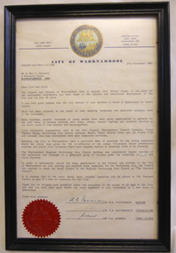
Letter - Citation City of Warrnambool Hayward, 1985
Cyril and Joyce Hayward migrated from England in 1955 and quickly became involved in the Arts in Warrnambool. They both became life members of the Warrnambool Theatre Company. Mrs. Joyce Hayward along with her husband Cyril, had a 30 year association with the Warrnambool Theatre Company. They acted, directed and produced a number of works from the 1950’s through to the 1980’s. Mrs. Hayward taught drama and speech at Warrnambool High School and St Ann’s College. They both worked towards reviving the Warrnambool Arts Council.. They were involved in Christ Church choir, readings for the blind, Probus and Penguin club. They retired to Bribie Island in 1985. Joyce Hayward died aged 97 in 2007.Joyce and Cyril Hayward played a significant part in the development of the Performing Arts and Education in Warrnambool over a 30 year period. They both received the Warrnambool Citizenship award. This letter expresses the gratitude of Council and citizens of Warrnambool to the Haywards for their contribution. Cream paper with body of letter typed and signed by the Mayor, a councillor and Town Clerk at the time. It has the City of Warrnambool crest at the top in light and dark blue with gold lettering and at the bottom left corner is the City of Warrnambool seal in red.Cr R.K. Patterson, Cr T, A, McCormack, V. G. Robson, Town clerk. warrnambool, cyril hayward, joyce hayward, citizen award, performing arts centre. -
 Warrnambool and District Historical Society Inc.
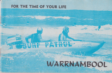
Booklet, For the time of your life Warrnambool, 1975
Tourist brochures have been produced in Warrnambool since the 1890s and this one has been published by the Warrnambool Chamber of Commerce and Industry. Some of the photographs for this brochure come from the Warrnambool Standard newspaper and the information on the car tours was provided by the Warrnambool Tourist Information Centre. Tourism in the Warrnambool region has always been of major importance to the town/city and a local Chamber of Commerce or Tourists’ Association has been active in the area for over 100 years. Today the official tourist guides are produced by the Warrnambool City Council. This brochure is a good example of local tourism promotion in the 1970s and will also be useful for display. This is a small booklet (1975) containing 39 pages. It has local Warrnambool advertisements, maps, photographs, printed material and details of 9 tours that tourists could take by car around Warrnambool. The pages are stapled. The front cover has a blue-tinged image of a surf boat patrol and the back cover has a black and white photograph of Warrnambool’s beach. There is one loose page with a summary of the tourist spots in Warrnambool and a map. Front Cover: ‘For the Time of Your Life – Warrnambool’.tourism in warrnambool, warrnambool -
Ringwood and District Historical Society
Badges, Badges and Coins 1939-45: 50 years of Queen Victoria's Reign; ANZAC Pins, King George and Queen Elizabeth; City of Wangaratta; etc, 1939 - 1945
Many issues - ANZAC DayBadges and coins. Refer photograph. +Additional Keywords: Pratt, G / GibbonTop Row L_R:; Victoria - 50 Years of Reign. Diam 3cm.; RDFA/Time Keeper (2 badges); Plastic 7-pointed badge (2 badges): Palestine-Gallipoli, FRANCE, Egypt, Mesopotamia, North Sea, New Guinea. In Centre: Lest We Forget printed across a map of Australia.; Assorted ANZAC pins/badges (5 badges); Middle Row L-R:; Side 1: King George VI & Queen Elizabeth (5 badges); Side 2: City of Wangaratta. Wangaratta Proclaimed a City.; Bottom Row:; Royal Life Saving Society, Established 1891. Centre: Awarded to G. Gibbon 1945.; Awarded to G Pratt v 1945; Victorian Rifle Association (2 badges); Legacy Badges/Pins (2 badges); Map of Australia on metal pin; Badge: Side 1 Centenary of Victoria 1934. On undeveloped scene embossed)/ Side 2 Centenary of Victoria 1935. (On city skyline embossed) Diam 2.6 cm.; Pavilion Fund Bayswater 1947-1948 -
 Ringwood and District Historical Society
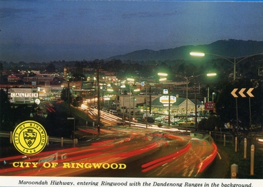
Postcards, Colorscans (Publishing) Pty Ltd, Various postcards of Ringwood in the 1970s, c. 1968
Postcards - pack of 6: 'Ringwood Victoria - tear off postcard folder - 6 views' (two identical folders); 1. Maroondah Highway, entering Ringwood with the Dandenong Ranges in the background (3303_001.jpg); 2. Aerial View of the City of Ringwood (3303_002.jpg); 3. Eastland Regional Shopping Centre at dusk (3303_003.jpg); 4. The Ringwood Memorial Clock Tower (3303_004.jpg); 5. The Civic Centre (3303_005.jpg); 6. The Ringwood Lake (3303_006.jpg) -
 Ringwood and District Historical Society
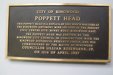
Plaque, City of Ringwood replica Antimony Mine Poppet Head commemorative plaque - 1987, 1987
Installed 12-April-1987 on the poppett head near the Ringwood Lake. It was removed c.2005.Plaque 'City of Ringwood/ Poppett Head' embossed. +Additional Keywords: Rosewarne, Lillian, Cr'City of Ringwood/ Poppett Head/ This Poppett head is a replica of one which was used at/ the Ringwood Antimony Mine located at the present/ Civic Centre Site, Mines Road, Ringwood east./ The Poppett head was erected by the/ Ringwood City Council, in conjunction with the/ Ringwood Historical Research Group, and was/ commissioned by the Mayor of Ringwood/ Councillor Lillian Rosewarne, JP/ on 12th April 1987/ -
 Ringwood and District Historical Society
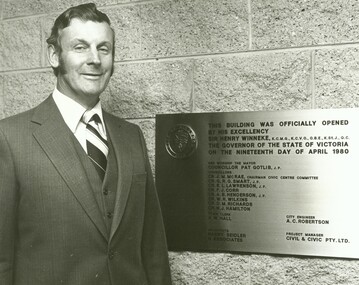
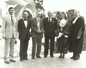
Photograph, Official opening of the Karralyka Centre, Mines Road, Ringwood on 19/4/1980 - Alan Robertson, City Engineer, standing next to plaque for the official opening by His Excellency Sir Henry Winneke, Governor of the State of Victoria, on the nineteenth day of April 1980, 19-Apr-80
... Official opening of the Karralyka Centre - Alan Robertson... Centre - Alan Robertson, City Engineer, standing next to plaque ...Official opening of the Karralyka Centre - Alan Robertson, City Engineer, standing next to plaque for the official opening by His Excellency Sir Henry Winneke, Governor of the State of Victoria, on the nineteenth day of April 1980. +Additional Keywords: Winneke, Sir Henry (Governor of the State of Victoria) / Robertson, Alan -
 Ringwood and District Historical Society
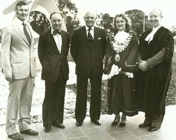
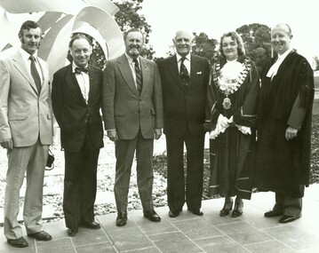
Photograph, Official opening of the Karralyka Centre, Mines Road, Ringwood on 19/4/1980, 19-Apr-80
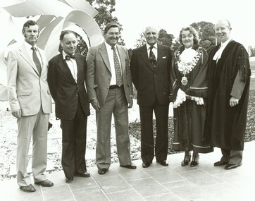
Official opening of the Karralyka Centre - L-R A.C. Robertson (City Engineer), Harry Seidler (Architect), Sir Henry Winneke, Cr Pat Gotlib (Mayor), Arthur W Hall (Town Clerk). +Additional Keywords: Winneke, Sir Henry (Governor of the State of Victoria) / Gotlib, Pat (Cr) / Hall, Arthur W. (Town Clerk) / Robertson, Alan C. (City Engineer) / Seidler, Harry -
 Ringwood and District Historical Society
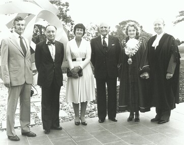
Photograph, Official opening of the Karralyka Centre, Mines Road, Ringwood on 19/4/1980 - L-R: A.C. Robertson (City Engineer), Harry Seidler (Architect), Lady Winneke - Ellis Fauld (uncertain), Victorian Governor Sir Henry Winneke, Cr Pat Gotlib (Mayor), Arthur W Hall (Town Clerk), 19-Apr-80
Official opening of the Karralyka Centre - L-R A.C. Robertson (City Engineer), Harry Seidler (Architect), Lady Winneke - Ellis Fauld (uncertain), Sir Henry Winneke, Cr Pat Gotlib (Mayor), Arthur W Hall (Town Clerk). +Additional Keywords: Robertson, Alan C. (City Engineer) / Seidler, Harry / Winneke, Lady (uncertain) / Winneke, Sir Henry (Governor of the State of Victoria) / Gotlib, Pat (Cr) / Hall, Arthur W. (Town Clerk) -
 Ringwood and District Historical Society
Photograph, Official opening of the Karralyka Centre, Mines Road, Ringwood on 19/4/1980 - L-R: A.C. Robertson (City Engineer), Harry Seidler (Architect), Cr Jack McRae, Victorian Governor Sir Henry Winneke, Cr Pat Gotlib (Mayor), Arthur W Hall (Town Clerk), 19-Apr-80
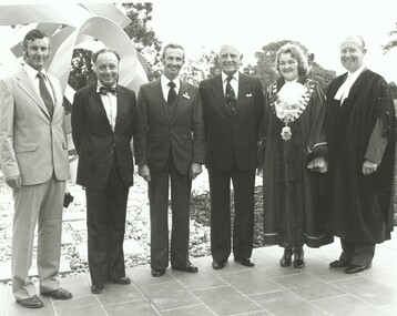
Official opening of the Karralyka Centre - L-R A.C. Robertson (City Engineer), Harry Seidler (Architect), Cr Jack McRae, Sir Henry Winneke, Cr Pat Gotlib (Mayor), Arthur W Hall (Town Clerk). +Additional Keywords: Robertson, Alan C. (City Engineer) / Seidler, Harry / McRae, Jack (Cr) / Winneke, Sir Henry (Governor of the State of Victoria) / Gotlib, Pat (Cr) / Hall, Arthur W. (Town Clerk) -
 Ringwood and District Historical Society
Photograph, Official opening of the Karralyka Centre, Mines Road, Ringwood on 19/4/1980 - L-R: A.C. Robertson (City Engineer), Harry Seidler (Architect), Cr Gerald Smart, Victorian Governor Sir Henry Winneke, Cr Pat Gotlib (Mayor), Arthur W Hall (Town Clerk), 19-Apr-80
Official opening of the Karralyka Centre - L-R A.C. Robertson (City Engineer), Harry Seidler (Architect), Cr Gerald Smart, Sir Henry Winneke, Cr Pat Gotlib (Mayor), Arthur W Hall (Town Clerk). +Additional Keywords: Robertson, Alan C. (City Engineer) / Seidler, Harry / Smart, Gerald (Cr) / Winneke, Sir Henry (Governor of the State of Victoria) / Gotlib, Pat (Cr) / Hall, Arthur W. (Town Clerk) -
 Ringwood and District Historical Society
Photograph, Official opening of the Karralyka Centre, Mines Road, Ringwood on 19/4/1980 - L-R: A.C. Robertson (City Engineer), Harry Seidler (Architect), (name unknown), Victorian Governor Sir Henry Winneke, Cr Pat Gotlib (Mayor), Arthur W Hall (Town Clerk), 19-Apr-80
Official opening of the Karralyka Centre - L-R A.C. Robertson (City Engineer), Harry Seidler (Architect), (name unknown), Sir Henry Winneke, Cr Pat Gotlib (Mayor), Arthur W Hall (Town Clerk). +Additional Keywords: Robertson, Alan C. (City Engineer) / Seidler, Harry / Winneke, Sir Henry (Governor of the State of Victoria) / Gotlib, Pat (Cr) / Hall, Arthur W. (Town Clerk) -
 Ringwood and District Historical Society
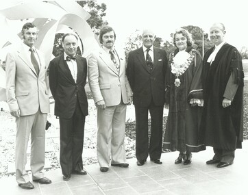
Photograph, Official opening of the Karralyka Centre, Mines Road, Ringwood on 19/4/1980 - L-R: A.C. Robertson (City Engineer), Harry Seidler (Architect), Cr Alan E Henderson, Victorian Governor Sir Henry Winneke, Cr Pat Gotlib (Mayor), Arthur W Hall (Town Clerk), 19-Apr-80
Official opening of the Karralyka Centre - L-R A.C. Robertson (City Engineer), Harry Seidler (Architect), Cr Alan E Henderson, Sir Henry Winneke, Cr Pat Gotlib (Mayor), Arthur W Hall (Town Clerk). +Additional Keywords: Robertson, Alan C. (City Engineer) / Seidler, Harry / Henderson, Alan E. (Cr) / Winneke, Sir Henry (Governor of the State of Victoria) / Gotlib, Pat (Cr) / Hall, Arthur W. (Town Clerk) -
 Ringwood and District Historical Society
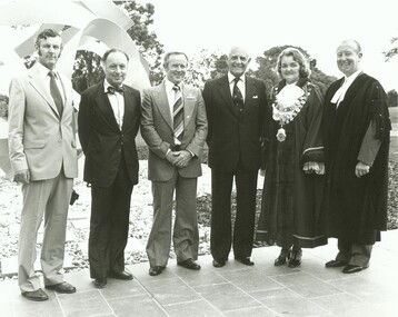
Photograph, Official opening of the Karralyka Centre, Mines Road, Ringwood on 19/4/1980 - L-R: A.C. Robertson (City Engineer), Harry Seidler (Architect), Cr Frank Corr, Victorian Governor Sir Henry Winneke, Cr Pat Gotlib (Mayor), Arthur W Hall (Town Clerk), 19-Apr-80
Official opening of the Karralyka Centre - L-R A.C. Robertson (City Engineer), Harry Seidler (Architect), Cr Frank Corr, Sir Henry Winneke, Cr Pat Gotlib (Mayor), Arthur W Hall (Town Clerk). +Additional Keywords: Robertson, Alan C. (City Engineer) / Seidler, Harry / Corr, Frank (Cr) / Winneke, Sir Henry (Governor of the State of Victoria) / Gotlib, Pat (Cr) / Hall, Arthur W. (Town Clerk) -
 Ringwood and District Historical Society
Photograph, Official opening of the Karralyka Centre, Mines Road, Ringwood on 19/4/1980 - L-R: A.C. Robertson (City Engineer), Harry Seidler (Architect), Cr W.R. Wilkins, Victorian Governor Sir Henry Winneke, Cr Pat Gotlib (Mayor), Arthur W Hall (Town Clerk), 19-Apr-80
Official opening of the Karralyka Centre - L-R A.C. Robertson (City Engineer), Harry Seidler (Architect), Cr W.R. Wilkins, Sir Henry Winneke, Cr Pat Gotlib (Mayor), Arthur W Hall (Town Clerk). +Additional Keywords: Robertson, Alan C. (City Engineer) / Seidler, Harry / Wilkins, W.R. (Cr) / Winneke, Sir Henry (Governor of the State of Victoria) / Gotlib, Pat (Cr) / Hall, Arthur W. (Town Clerk) -
Ringwood and District Historical Society
Eisteddfod, Sponsored by Ringwood City Council, Programme for 50th Annual Ringwood Eisteddfod 2004, at Senior Citizens Centre, 2004
Programme covering 50th Annual Ringwood Eisteddfod 18/6/2004-5/7/2004 held at Senior Citizens, Ringwood. 3 page booklet. +Additional Keywords: Hawkins, Ruth -
 Ringwood and District Historical Society
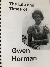
Book, The Life and Times of Gwen Horman with photos and family trees, 25-Sep-98
Gwen Horman was a prominent figure in Ringwood History. Her husband , Robert, was the Mayor of the Ringwood Borough in 1954 and again in 1961 and played a large part in the move for Ringwood to become a city. Gwen was a foundation member and President of the Ringwood East Infant Welfare Centre, helped fund raise for the Maroondah Hospital and was a founding member of the Ringwood East CWA in 1949. She traveled extensively and there are many diary notes of these trips included in the history.Transparent front cover and buff coloured back cover, black spiral binding contains 38 pages of printed notes and photos, some hand written amendments. Printed 25-Sep-1998. +Additional Keywords: Horman, GwenLife and times of Gwen Horman