Showing 870 items
matching stone building
-
 Queen Victoria Women's Centre
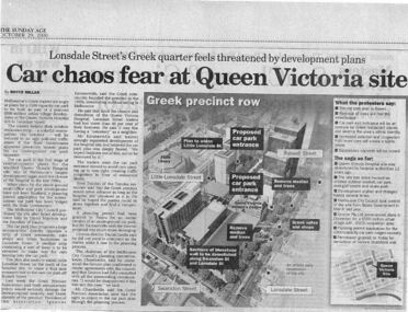
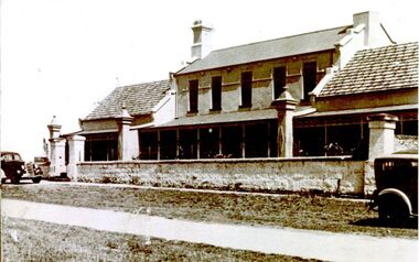
Newspaper excerpt, The Sunday Age, Car Chaos fear at Queen Victoria Site: Lonsdale Street's Greek quarter feels threatened by development plans, 29 October 2000
Newspaper excerpt from The Sunday Age. Page 5 and a smaller introduction probably from the front page. Smaller excerpt colour photo of blue-stone and cast-iron wall which was to be demolished. Larger excerpt, a black and white aerial view of QVWC and the block where it is situated. building construction, building permits, historic building -
 Queen Victoria Women's Centre
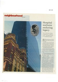
Magazine excerpt, Hospital nurtures enduing legacy, 13-19 September 2006
Inside - Neighbourhood page 30, 32 and 33. Page 30: Colour photograph of QVWC building facade. Black and white portrait of Dr Constance Stone. Page 32: Two coloured portraits one of Kay Setches and the other, Cheryl Teng CEO. Page 33: Black and white photograph of the Queen Victoria Hospital. historic buildings, women's history, official events -
 Sunbury Family History and Heritage Society Inc.
Photograph, c 1920s
The 'Meeise' French car is parked outside the former Mechanics Institute Hall in Stawell Street, Sunbury. J Eadie was responsible for the building of the hall in 1885 and the foundation stone was laid by Lady Janet Clarke. The former Shire of Bulla conducted their council meetings in the hall from 1923 until 1956 when new offices were built in Macedon Street. Later the RSL took over occupancy of the hall and it became known as the Memorial Hall. In the early 1970s Stawell Street was cut off to traffic and incorporated into the Village Green.Over the years the Memorial Hall has been the venue for many community events from debutant balls, flower shows, local gatherings, celebrations and markets to name a few.A sepia photograph with a cream border of a tree lined street with a building in the foreground and a vintage car parked outside the building. Tall pine trees are growing behind the fenceline.mechanics institute, shire of bulla -
 Sunbury Family History and Heritage Society Inc.
Photograph, Rupertswood Mansion
The grand building is Rupertswood Mansion which was the Sunbury home of the Clarke family. The foundation stone was laid29th August 1874 by Mrs. W.J. Clarke the first wife of W.J.Clarke. The property along with the Clarke family have been interwoven with Sunbury's history over the decades and remained in the Clarke family until 1922 when H.V. McKay of Sunshine Harvester fame purchased the property. The Salesian Fathers purchased it in 1927 and since that time the property has been a school. Many important events have taken place in Sunbury within the Rupertswood grounds over the years. A non-digital black and white photograph of a double storey grand mansion with a return verandah on the ground floor and a balcony with decorative iron lace across the front. An elegant tower is over the main entrance.rupertswood estate, rupertswood mansion, w.j.clarke -
 Sunbury Family History and Heritage Society Inc.
Photograph, St. Andrew's Presbyterian Church
... weather board building and the foundation stone was laid... building and the foundation stone was laid for the new church ...The Government first granted land for the building of a Presbyterian Church in Sunbury in Stawell Street and Barkly Street, in 1864 and a smaller building was later erected on the site. In 1904 Rev Goyen pressed for a brick church rep[lace the smaller weather board building and the foundation stone was laid for the new church was laid by Mrs. John Duncan on 17th August 1904 and the new church opened by Lady Clarke on 13th November 1904.The Presbyterian Church was one of the earliest churches to be established in Sunbury along with a school.A non-digital sepia photograph in post card format of the front view of a brick church with a light picket fence across the front. -
 Sunbury Family History and Heritage Society Inc.
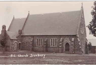
Postcard, R.C. Church Sunbury
On 17th January 1856, two acres of land was granted for the building of a school and church on that site in Macedon Street. A small temporary building was erected on the site and on 13th December 1864 the foundation stone was laid for the new stone church which was known as 'Our Lady of Mount Carmel'Is one of the oldest churches to be established in Sunbury.A non-Digital post card photograph of the Roman Catholic Church in Sunburyour lady of mount carmel catholic church, macedon street, sunbury -
 Sunbury Family History and Heritage Society Inc.
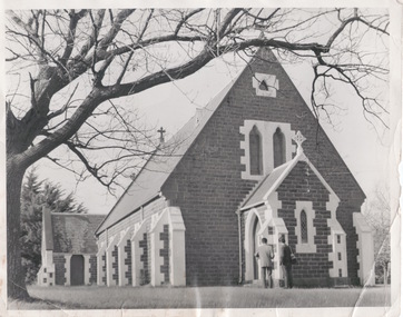
Photograph, St. Mary's Anglican Church - Sunbury
Contextual information relating to St.Mary's Church is entered on P0877. This image was used for a newspaper article An enlarged non-digital black and white photograph with a cream border of a blue stone church with white rendered columns around the windows and door and a pitched slate roof. Two men are standing beside the porch and the vestry is visible at the rear of the main building. A bare deciduous tree is on the LHS of the image -
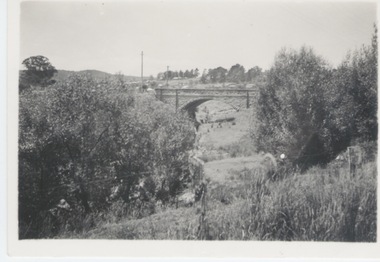
 Sunbury Family History and Heritage Society Inc.
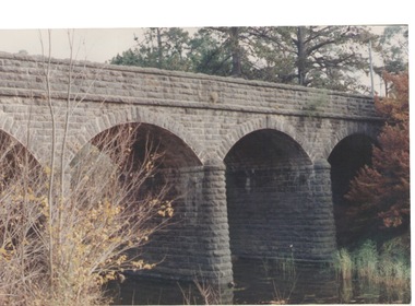
Photograph, Bulla Bridge, c 1980s
The bridge in the photograph is the bluestone bridge at Bulla which spans the Deep Creek, a tributary of the Maribyrnong River. It was built in 1869 and replaced a ford crossing which was built further downstream. Many of the buildings and structures in the area were built from bluestone which is in abundance throughout this volcanic area.This bridge is one of many similar structures built across Western Victoria where the bluestone volcanic rock was found in abundance.A coloured close - up photograph of a four-arched blue stone bridge spanning a waterway. Some greenery is visible on either side of the bridge and above it. bulla bridge, bluestone, bridges, deep creek. -
 Sunbury Family History and Heritage Society Inc.
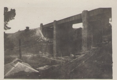
Photograph, Rupertswood Viaduct
The stone bridge is one of the many bridges built along the Bendigo Rail Line. This one along with four others ar in Sunbury which were built in the late 1850s. his bridge spans the Ruoertswood Viaduct which is north of the Sunbury Station. The building in the LH corner was a pump house where water was pumped and taken to the water tower on Sunbury Station where the steam trains stopped to replenish the water tanks. The Bendigo Rail Line was the first Government owned and operated to be constructed in Victoria. Along the railway a number of famous bridges and tunnels were built and are of historical significance. The bridge spanning the Rupertswood Viaduct is one of them. A black and white photograph with a cream border of a high bridge spanning a deep valley. The roof of a small building is visible in the bottom LHS corner of the photograph.bridges, railways, rupertswood viaduct -
 Sunbury Family History and Heritage Society Inc.
Photograph
The single span bluestone bridge is on the Calder Highway at the base of Corkscrew Hill between Gap Road and the town of Gisborne. In the early 1990s the highway was widened and dual carriageways constructed, as a result the traffic no longer travelled along the winding Corkscrew Hill road. The bridge still stands between the two carriageways. A black and white photograph with a cream border of a single arched stone bridge spanning a watercourse. Small bushes are growing in the foreground and there are some buildings dotted across the hill in the middle distance.bridges, corkscrew hill, calder highway -
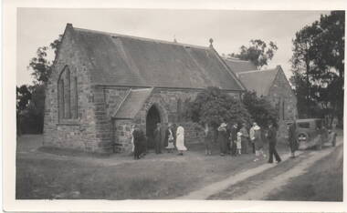 Sunbury Family History and Heritage Society Inc.
Photograph, c 1930s
... . It was established in 1859. With there building of the Melbourne Airport.... It was established in 1859. With there building of the Melbourne Airport ...St. Mary's Anglican Church at Bulla originally occupied a site along Oaklands Road, adjacent to 'Woodlands' homestead. It was established in 1859. With there building of the Melbourne Airport at Tullamarine it was found that the church on its existing site was directly under the flight path of the aircraft so the building was demolished stone by stone and rebuilt in the Bulla township adjacent to the Alistair Clark Rose Garden. The original site has not been developed because some early graves are there.St. Mary's Church at Bulla is one of the earliest to be established in the Bulla district. Its mother church, St Pauls Church of England at the original Broadmeadows township was established in 1850 and it still stands and operates on its original site.A black and white photograph with a cream border of a stone church with the congregation members entering the church. A saloon car is parked near the church.st. mary's church of england, bulla., churches. -
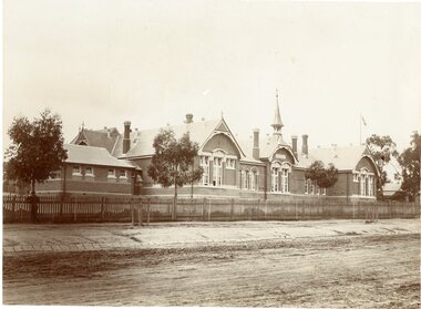 Stawell Historical Society Inc
Photograph, Stawell Primary School Number 502 showing the Front of Building, Bell Tower & Bluestone pitchers for the Road Kerbing
Stawell Primary School 502 - Very early photo with timber picket fence. Three trees growing inside fence. Stone pitchers form guttering. One person standing near fence on left of photo.stawell education -
 Stawell Historical Society Inc
Photograph, “Swinton” Homestead in Glenorchy with outbuildings on the right 1991, 1991
B/W photo of “Swinton” Homestead showing outbuildings at right of photo. 1991B/W Photgraph: Swinton with stone drive in mid distance. This view is taken from a lsightly differnet angle and shows out buildings, presumably at the rear. This photo is taken in 1991 - From the Stawell time news 4/10/1991.glenorchy -
 Surrey Hills Historical Society Collection
Photograph, Baby Health Centre in the Surrey Gardens, 1982, 1982
The Baby Health Centre opened in the Surrey Gardens in 1930 on the site previously occupied by the screen for outdoor pictures. Previously during the 1920s it had operated in the room underneath the rotunda in the Surrey Gardens. The room was also shared by other groups including the Surrey Hills Progress Association (SHPA). The SHPA raised 200 pounds to provide the materials for the building, which was built by voluntary labour under the leadership of Ralph Hayes, a local builder. The foundation stone was laid by Mrs A Latham, Mayoress of Camberwell on 31 March 1930. There is a bottle containing the names of the committee members sealed in the pillar behind the memorial stone. The centre was managed by a committee until 1975. Maternal health nurses associated with the centre included Sister D Thompson, Sister Newnham, Sister Kelsell, Sister Barker, Sister Sharp and Sister Bolton. Ref: Mrs D Lancashire - a long-serving member of the committee. The site of the Surrey Hills Maternal and Child Health Centre was moved to 18 Verdun Street, adjacent to the pre-school, in accord with Council policy to co-locate services and from a concern regarding solo staff working in relatively isolated locations. The building was included in the heritage overlay protecting the gardens and was refurbished by Council for community use. The cairn commemorates the work of Cr Albert Ernest Vine who was a Camberwell Councillor from 1926-1934 and 1937-1944; he was also Mayor on 1940-41. There is a photo of him in Mayoral robes in the City of Boroondara Library Service collection.Black and white photo of a timber building with a tiled roof and a brick veranda supported by brick and concrete pillars. In front of the baby health centre is a small cairn.surrey gardens, baby health centres, monuments and memorials, surrey hills progress association, cr albert ernest vine, sister d thompson, sister d. newnham, sister kelsell, sister barker, sister sharp and sister bolton, mrs a latham, ralph hayes, mrs d lancashire -
 Surrey Hills Historical Society Collection
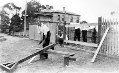
Photograph, St George's Church of England, Mont Albert working bee, early 1923 (2), 1923
The foundation stone for St George's Church of England, Mont Albert was laid in 1886 on land donated by Edward Dyer and the first service was preached in January 1887. From 1904 until 1907 it was known as Holy Trinity, Surrey Hills. The original church was weatherboard and replaced by a brick one in the Gothic Revival style which was designed by local architect George J V Blackburne, who also designed the Wesleyan School at Surrey Hills. The building was partly funded by donations, profits from a bazaar and concert, and other people donated furnishings. The church had boundaries along Mont Albert Road and St Georges Road. In 1998 the Church was sold and converted into a complex of units. Its current address is 19 St Georges Avenue, Mont Albert. The purpose of this working bee in 1923 was to close up the double gateway, which in earlier times had been used for entry of by horse-drawn vehicles to the church grounds. 'Lugano' was built in 1893 for William Wilson, a prominent stonemason and importer of marble fireplaces. In 1903 it became the home of William Holmes who was Chief Electrical Engineer for the Victorian Railways. He designed the electrification of the Melbourne suburban network. 'Lugano' stayed in the Holmes family until the 1930s. Norman Carter took many photos of Surrey Hills and Mont Albert from the 1920s in particular of events and activities associated with the Church of England.Black and white photo of 6 men behind and in front of a picket fence, a section of which has posts and railings only. In front of the fence is a wide grassy verge on which a bench is set up for cutting lengths of wood. A large Victorian house ('Lugano') can be seen in the background and a lamp post with a street sign. Beyond the house are mature eucalyptus trees.churches, holy trinity church, anglican church, st george's anglican church, working bees, lugano, william holmes, william wilson, norman brodley carter -
 Surrey Hills Historical Society Collection
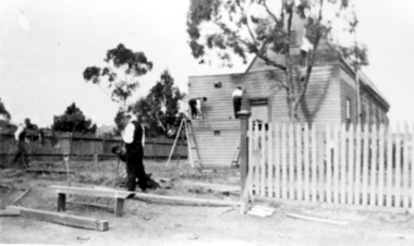
Photograph, St George's Church of England, Mont Albert working bee, early 1923 (1), 1923
The foundation stone for St George's Church of England, Mont Albert was laid in 1886 on land donated by Edward Dyer and the first service was preached in January 1887. From 1904 until 1907 it was known as Holy Trinity, Surrey Hills. The original church was weatherboard and replaced by a brick one in the Gothic Revival style which was designed by local architect George J V Blackburne, who also designed the Wesleyan School at Surrey Hills. The building was partly funded by donations, profits from a bazaar and concert, and other people donated furnishings. The church had boundaries along Mont Albert Road and St Georges Road. In 1998 the Church was sold and converted into a complex of units. Its current address is 19 St Georges Avenue, Mont Albert. Norman Carter took many photos of Surrey Hills and Mont Albert from the 1920s, in particular of events and activities associated with the Church of England.Black and white photo of 4 men at a working bee in the grounds of St George's Anglican Church in Mont Albert. Two men are on a scaffold working on the weatherboards of the church; the other two are working on fencing. One boundary is marked with a paling fence; the other has a section of picket fencing and a large open section with no fencing. There is a mature eucalyptus tree in front of the church; others are beyond the paling boundary fence. The church itself is a simply constructed weatherboard building.churches, holy trinity church, anglican church, st george's anglican church, working bees, norman brodley carter -
 Surrey Hills Historical Society Collection
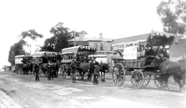
Photograph, Preparing to leave for the St George's Church of England Sunday School picnic, Mont Albert Road, 1922, 1922
The drags would have been leaving St George's Church of England in Mont Albert Road. The foundation stone for St George's Church of England, Mont Albert was laid in 1886 on land donated by Edward Dyer and the first service was preached in January 1887. From 1904 until 1907 it was known as Holy Trinity, Surrey Hills. The original church was weatherboard and replaced by a brick one in the Gothic Revival style which was designed by local architect George J V Blackburne, who also designed the Wesleyan School at Surrey Hills. The building was partly funded by donations, profits from a bazaar and concert, and other people donated furnishings. The church had boundaries along Mont Albert Road and St Georges Road. In 1998 the Church was sold and converted into a complex of units. Its current address is 19 St Georges Avenue, Mont Albert. The annual Sunday School picnic was held at Hampton and drags were the usual mode of transport. 'Lugano' was built in 1893 for William Wilson, a prominent stonemason and importer of marble fireplaces. In 1903 it became the home of William Holmes who was Chief Electrical Engineer for the Victorian Railways. He designed the electrification of the Melbourne suburban network. 'Lugano' stayed in the Holmes family until the 1930s. The annual Sunday School picnic was held at at a variety of locations and drags were the usual mode of transport. Donor information is that this was taken as the congregation prepared to depart for at Hampton on the picnic held on 25/2/1922. There are 2 copies: the original donated print and an enlargement. The original was mounted on card with photo mounts along with 506, 871, 872, and 873. It measures 13 cm x 9 cm.Black and white photo of 4 'drags' (horse-drawn hooded carriages) lined up in Mont Albert Road near the corner of St George's Avenue, in readiness for departure for the Sunday School picnic. The carriages are loaded with people and decorated with flags. The front carriage has a material sign attached to the side; the top line of writing is not decipherable, but the bottom one reads "SURREY HILLS". Four men stand in the road, which has bluestone curb and channelling. In the background is 'Lugano'.On rear in ink: "S.S. picnic to Hampton / 25th. Feb. 1922" and in a different hand in biro: "At Mont Albert. St George's Church"churches, holy trinity church, anglican church, sunday schools, picnics, lugano, horse-drawn vehicles, william wilson, willaim holmes, st george's church of england, mont albert, mont albert road -
 Surrey Hills Historical Society Collection
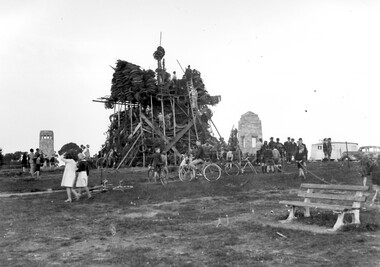
Photograph, Bonfire, Beckett Park, Balwyn (Surrey Hills), c1937/8, 1937
"The bonfire at Beckett Park was the culmination of the EMPIRE DAY/CELEBRATIONS in Surrey Hills in 1935 and 1936. In 1937 vandals lit the fire prematurely but residents hastily rebuilt it - about / 100 tons including old tyres. A volunteer fire-watcher had his caravan close by until lights-up time on Saturday night. / Courtesy Ian Barkla. / see 180 (handwritten on backing board)." / "BONFIRE BUILDING at BECKETT PARK/EMPIRE DAY CELEBRATIONS IN 1930s/ The celebrations were centred on the/ shopping centres in Surrey Hills and/Mont Albert to boost local business (and/ the spirits of residents) after the Depression./ - from a glass negative - Mr Ian Barkla."Image depicting the building of a large bonfire made primarily from rubber tyres, supported by a wooden frame c1937/8. There is a significant crowd of people watching the erection of the pyre from ground level. Several members of the crowd are seated or holding bicycles. There are multiple persons situated on the pyre or on a ladder propped up against the mound of tyres. The area containing the pyre has been fenced off with rope (?). A white coloured caravan in situated to the right (facing) of the bonfire in close proximity to a dark coloured car. Two stone towers and a park bench are also visible in the image.Black and white, W 25.3 cm x H 20.3 cm, landscapeparks and reserves, beckett park, balwyn, bicycles, crowds, empire day, depression 1929-1939, economic depression, frank leslie barkla, bonfires -
 National Wool Museum
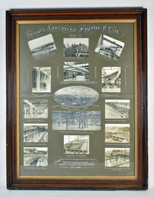
Photograph - Construction of Dennys Lascelles Austin & Co's Reinforced Concrete Wool and Grain Stores, Geelong, Edward Giles Stone, 1910-1912
Through improvements in productivity after 1095, Dennys, Lascelles, Austin and Co. determined to expand and engaged the Sydney-based engineer Edward Giles Stone. The resulting Bow Truss Building was claimed as being the largest flat-roof space in the world (almost an acre) without visible support. The Bow Truss Building was demolished amid a blaze of publicity in May 1990.Collage of 15 photographs mounted in a grey/brown cardboard backing depicting various stages of construction of wool & grain stores. Wooden frame.Wording: Dennys Lascelles Austin & Co. 1910-11;Location: Top centre Wording: G.C. Wilmot Photo Geelong;Location: Bottom right cornerdennys, lascelles, austin, construction, grain, wool, building, geelong, architecture -
 Vision Australia
Object, Time capsule 1868, 1868
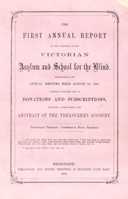
In 1868, with the laying of the foundation stone, a time capsule was placed containing four newspapers of the day (Saturday 25 January, 1868 - The Age, The Argus, The Sun and The Telegraph: St Kilda, Prahran and South Yarra Guardian), the first Annual report of the Victorian Asylum and School for the Blind (1867), 11 coins from the Victorian regency and an illustration of the proposed building at St Kilda Road. In 1991, this time capsule was opened as part of 125 year celebrations. An undated note also describes a piece of parchment in the time capsule, which contained a list of names of committee members and relevant people involved in the construction of the building, such as Crouch & Wilson; however no image of this has been located.4 newspapers, 1868 circulating Commonwealth coins, 1867 Asylum and School for the Blind Annual Report and an illustration of the proposed building in St Kilda Road.royal victorian institute for the blind -
 Vision Australia
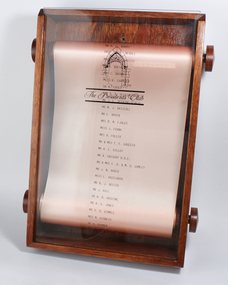
Textile - Object, Royal Blind Society Presidents club scroll
Rose pink satin scroll with names of donors printed upon it rests inside a brown wooden box. A plastic cover protects the scroll, and printed upon this is an image of the stone archway (from the first building housing the Sydney Industrial Blind Institution) as well as the words 'The Presidents Club'. To view the scroll, turn the handles up or down. List of names represents people who donated to an appeal (date unknown). Box was designed to be mounted on a wall.Wooden box with satin scroll of printed namesThe Presidents Clubroyal blind society of nsw, fundraising -
 Port Fairy Historical Society Museum and Archives
Photograph
Kildare Cottage - Cox Street. Dominic Keating at door.Black and white photograph of stone cottage with gentleman standing in doorway and dog in gateway of picket fencekildare cottage, cox street, dominic keating, cottage, house, building -
 Port Fairy Historical Society Museum and Archives
Photograph
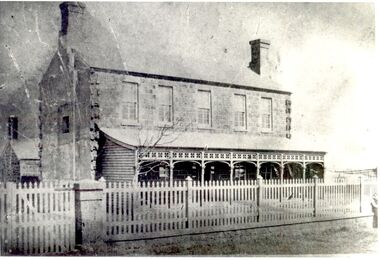
The land for this building was granted to the Benevolent Society by James Atkinson in 1850. Tenders were being called for a new "Benevolent Asylum" in 1855, the foundation stone having been laid and by 1856 the first part of the Hospital was completed. This photo taken in 1860 shows the very first building made from local bluestone. The hospital is thought to be the first such building in VictoriaBlack and white photograph of Bluestone 2 story building with verandah and paling fencehospital, institution -
 Port Fairy Historical Society Museum and Archives
Photograph
The land for this building was granted to the Benevolent Society by James Atkinson in 1850. Tenders were being called for a new "Benevolent Asylum" in 1855, the foundation stone having been laid and by 1856 the first part of the Hospital was completed. These extensions probably carried out 1930's?????Black and white photograph of Right side of hospital new extension with bay windowshospital, institution, health service, extension, benevolent asylum, benevolent society -
 Port Fairy Historical Society Museum and Archives
Photograph, circa 1934
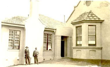
The land for the original building was granted to the Benevolent Society by James Atkinson in 1850. Tenders were being called for a new "Benevolent Asylum" in 1855, the foundation stone having been laid and by 1856 the first part of the Hospital was completed These extensions opened in November 1934 People possibly builder and contractorBlack and white photographs of the side extension added to the Port Fairy Hospital in 1934hospital, public buildings -
 Port Fairy Historical Society Museum and Archives
Photograph, circa 1932
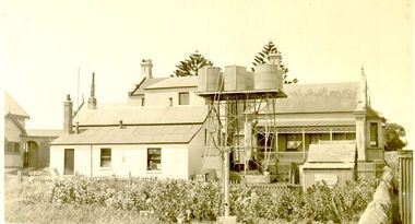
The land for this building was granted to the Benevolent Society by James Atkinson in 1850. Tenders were being called for a new "Benevolent Asylum" in 1855, the foundation stone having been laid and by 1856 the first part of the Hospital was completed. This photograph shows the completion of early extensions and how the Hospital has expandedSepia photograph of Buildings at the back of the hospital with large tank standhospital, institution -
 Port Fairy Historical Society Museum and Archives
Photograph
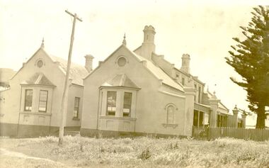
The land for this building was granted to the Benevolent Society by James Atkinson in 1850. Tenders were being called for a new "Benevolent Asylum" in 1855, the foundation stone having been laid and by 1856 the first part of the Hospital was completed. this photograph shows there have been extensions to both sides of the hospital by this time 1920Black and white photograph of Exterior of hospital with verandah stone fence and gates two cars hospital, institution, villiers street, benevolent asylum, health service -
 Surrey Hills Historical Society Collection
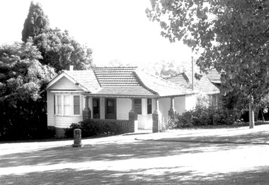
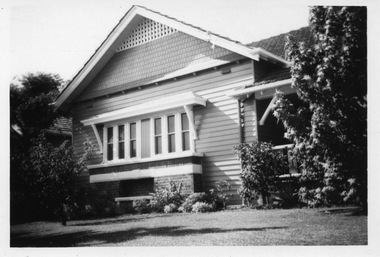
Digital photo, George L Coop, 688 Whitehorse Road, Mont Albert c 1953, c1953
This was the home of 3 generations of the Coop family: 1. Josephine and George Frank Coop (noted in Box Hill Rate Books for 1947-1954). 2. George Burton Coop (1906-1960) and his family. He was Assistant Chief Architect of Victoria in the Public Works Department (P.W.D.) George Burton Coop was born in c1906 in Williamstown, the son of Josephine Vistarini and George Frank Coop. He married Winifred Alice Trewartha in 1936 and they are listed in the electoral rolls at 688 Whitehorse Road in 1937. George died 3/4/1960, aged 54 years at Mont Albert. 3. George Burton and Alice Coop had 2 children: George Lister Coop - born St Georges Hospital, 8/10/1937 Alison - born c1945. The donor George Lister Coop informed that he initially attended Chatham State School because his first home was the Spanish Mission style flats at 346 Whitehorse Road, opposite Brenbeal Street, Balwyn. When his grandparents died, the family moved to 688 Whitehorse Road and he then attended Mont Albert Central School. The California bungalow style of housing was the dominant style of housing built in the interwar period through the northern parts of Surrey Hills and Mont Albert as formerly semi-rural land was subdivided for new housing. It was relatively inexpensive and affordable. In Australia the Californian bungalow drew upon elements that were popular across the United States from around 1910 to 1939. In Australia the style became popular from 1913. In Melbourne both timber and red brick were used as the main building material. Typically they are one or one and a half story houses and feature sloping roofs and eaves with unenclosed rafters and often a feature a dormer window (or an attic vent designed to look like one) over the main portion of the house. Decorative elements include wood shingles, part stucco rendered exteriors, brick, stone, rendered or a combination of these treatments to exterior chimneys and front porches supported by heavy timber, brick or stucco columns.A black & white photo taken at an angle of a Californian bungalow.californian bungalow, whitehorse road, george frank coop, (miss) josephine vistarini, (mrs) josephine coop, george burton coop, (miss) winifred trewartha, (mrs) winifred coop, george lister coop, alison coop -
 Surrey Hills Historical Society Collection
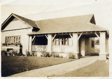
Digital photo, George L Coop, 688 Whitehorse Rd. Mont Albert c1950, c1950
This was the home of 3 generations of the Coop family: 1. Josephine and George Frank Coop (noted in Box Hill Rate Books for 1947-1954). 2. George Burton Coop (1906-1960) and his family. He was Assistant Chief Architect of Victoria in the Public Works Department (P.W.D.) George Burton Coop was born in c1906 in Williamstown, the son of Josephine Vistarini and George Frank Coop. He married Winifred Alice Trewartha in 1936 and they are listed in the electoral rolls at 688 Whitehorse Road in 1937. George died 3/4/1960, aged 54 years at Mont Albert. 3. George Burton and Alice Coop had 2 children: George Lister Coop - born St Georges Hospital, 8/10/1937 Alison - born c1945. The donor George Lister Coop informed that he initially attended Chatham State School because his first home was the Spanish Mission style flats at 346 Whitehorse Road, opposite Brenbeal Street, Balwyn. When his grandparents died, the family moved to 688 Whitehorse Road and he then attended Mont Albert Central School. The California bungalow style of housing was the dominant style of housing built in the interwar period through the northern parts of Surrey Hills and Mont Albert as formerly semi-rural land was subdivided for new housing. It was relatively inexpensive and affordable. In Australia the Californian bungalow drew upon elements that were popular across the United States from around 1910 to 1939. In Australia the style became popular from 1913. In Melbourne both timber and red brick were used as the main building material. Typically they are one or one and a half story houses and feature sloping roofs and eaves with unenclosed rafters and often a feature a dormer window (or an attic vent designed to look like one) over the main portion of the house. Decorative elements include wood shingles, part stucco rendered exteriors, brick, stone, rendered or a combination of these treatments to exterior chimneys and front porches supported by heavy timber, brick or stucco columns.A sepia photo taken at an angle from the street corner of the property. It is of a Californian bungalow with a driveway that extends through a carport, attached and roofed as part of the house, to the rear of the property. The veranda is accessed from under this covered area. The veranda and carport are supported by brick pillars and the veranda balustrades between are plain with an occasional wider feature panel. The front door is in shadow. There are rolled up striped canvas blinds on the veranda and at least 2 cane chairs. The main structure of the house is weatherboard with a terracotta tiled roof. There is a flower bed across the front of the house with an elevated brick flower box under the main window. There are no chimneys visible.californian bungalow, whitehorse road, george frank coop, (miss) josephine vistarini, (mrs) josephine coop, george burton coop, (miss) winifred trewartha, (mrs) winifred coop, george lister coop, alison coop -
 University of Melbourne, Burnley Campus Archives
Album, Sandra Pullman, National Estate/Heritage Register Photographs, 2001
Photograph Album sent in with the National Estate/Heritage Register by Sandi Pullman. (1) Old car park (Bull Paddock) with Cork Oak. (2) Main Building front steps. (3) Main Building with Magnolia grandiflora. (4)View of Luffmann Ponds and old willow. (5) View of Ginkgo and Emily Gibson bed. (6) Looking between Emily Gibson beds to English Oak. (7) Summer House. (8) Luffmann Ponds. (9) Bergenia Walk with conifers. (10) View of Pencil Pines around entrance to Sunken garden. (11) Luffmann Ponds and Pinus canariensis. (12) View of entrance to Sunken garden. (13-14) Sunken garden. (15) Original terracing at entrance to Shady Walk. (16) Pears in blossom in Field Station. (17) Agathis robusta from the Herb Garden. (18) Ellis Stones Rock garden newly replanted. (19) james Hitchmough Grasslands. (20) Elm tree with Dairy in the background. (21) Original Red Gum in james Hitchmough Grasslands. (22) Kath Deery Native garden. (23-24) Rose Garden. (25) Sequoiadendron giganteum.national estate, heritage register, sandi pullman, sandra pullman, bull paddock, cork oak, magnolia, luffmann ponds, willow, ginkgo, emily gibson bed, english oak, summer house, bergenia walk, conifers, pencil pines, sunken garden, pinus canariensis, shady walk, pears, blossoms, field station, agathis robusta, herb garden, ellis stones rock garden, james hitchmough grasslands, elm tree, dairy, red gum, kath deery native garden, rose garden, sequoiadendron giganteum.