Showing 3840 items matching "1850s-1900s"
-
 Kiewa Valley Historical Society
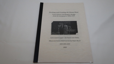
Book - Kiewa River, Stocking and Crossing the Kiewa River by Jan Hunter (nee Chick), 2020
The Chick brothers, Alf, Les and Allan, plus friends, began trout fishing and camping in the Kiewa Valley before the early 1930s. Les continued his connection with the Kiewa River until his death in 1972. Fingerlings were placed in the Kiewa River from the early 1880s. Keegan's Bridge is a crossing near Upper Gundowring and about 4 km south east of Dederang. References to the crossing were made in the early 1900s and a petition presented to Council in 1904 calling for a bridge.The bridge was built and opened in 1907. The photos are of the release of fingerling trout in the Kiewa River, thought to be at Keegan's Bridge. The fingerlings were transported in drums on the back of trucks. The photos are c1940s.The Kiewa Valley has been a popular spot for fishermen, tourists and campers from the 1880s. One of the many attractions has been the excellent fishing along the Kiewa River due to the regular release of fish especially brown trout. This continues to the present day (2020) when a few fish were marked with $$ signs for the lucky fisherman who caught them. This attracts visitors, their families and boosts the economy and dates back to visits at the Tawonga Pub prior to the Kiewa Hydro Electric Scheme.19 page book with black plastic spine and clear plastic cover over the beige paper cover with title , author and black & white photo. Note: In KVHS photo collection there are 4 good quality reproduction photos on photographic paper. These have been produced professionally. These photos of Jan Hunter's are featured on the second page of her book. These also have a letter attached. The book is a pre-research paper & is No 33 of the Albury and District Historical Society Papers. The sub-title is "Trout releases and Keegan's Bridge / from the newpapers, 1882-1935"None on the book but a letter is attached from Jan Hunter, the author as a follow up to the photos she donated. On the photos - On the back: Fujifilm / Fujicolor Crystal Archive / Paper / Production - run codekiewa river; trout; fish; keegan's crossing; keegan's bridge; fingerlings; chick family; camping; tourism -
 Federation University Historical Collection
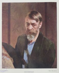
Book, The Shepherd Press, The Science of Appearances as Formulated and Taught by Max Meldrum, 1950
This book could be described as the summing up of a theory of physical appearances, devised by a painter and demonstrated by paint. The foundation of this theory was laid down first in Paris by Max Meldrum early 1900s. A review calls the book "the most outstanding book on the craft of painting yet published in any language. Max Meldrum was born in Edinburgh, Scotland on 03 December 1875. His family arrived in Australia and Max Meldrum attended the National Gallery School, winning the Victorian Travelling Scholarship in 1899. It was deaccessioned and transferred from the Ballarat School of Mines library so would have been used by students and staff of the Ballarat Technical Art School, a division of the Ballarat School of Mines. Red fabric hard covered book of 298pp, includes colour plates that have been pasted into the book. The book inlcudes 11 colour prints and 11 line and tone diagrams. These diagrams in clude Major and Minor Dark and liLight Disturbances; Speed Values and Form; Complex Light Disturbance; Experiments in Definition and Inclination; Apparatus for the Analysus of Visual Phenomena by Distance; Set of Patches; Modern and Obsolete Methods of Approach, Tonal Analysis on "St John's Parad"'; Chromatic Analysis of "St John's Parade". This book was part of the Ballarat Technical Art School LibraryA review has been pasted in the front..max meldrum school, max meldrum, art, science of appearances, appearances, color plates, tonalism, ballarat school of mines library, ballarat technical art school -
 Warrnambool and District Historical Society Inc.
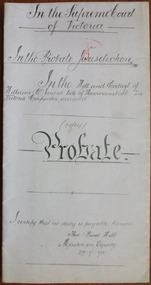
Document - William McJannet Probate 1898, 1898
Tait collection: item 44 of 62 This document gives details of the Will and Probate of William McJannet, a Warrnambool carpenter who died in 1898 at the age of 80. He and his wife and two of his children came to Australia from Scotland in the 1850s and at the time of his death he was living in Raglan Parade. He left real estate to the value of £400 and the beneficiaries were his children. The lawyer concerned with this document, H. Parrington, had legal offices in Kepler Street with the firm known as Higgins and Parrington but Mr Parrington was in partnership with Mr J.Tait when this document was drawn up. The document has been passed down to successive lawyers occupying the Kepler Street premises and located in this building in 2014. This document is of some importance as William McJannet was a well-known resident of Warrnambool in the 19th century. The document will be useful to researchers. This is a piece of white paper folded in two with printed red lines on the edges of three of the pages. Three pages have typed material and one page has handwritten material in black ink. It gives details of the Will and Probate of William McJannet who died in 1898. In the Supreme Court of Victoria In the Probate Jurisdiction In the Will and Codicil of William McJannet late of Warrnambool Victoria Carpenter deceasedwilliam mcjannet, h.r.parrington, warrnambool, tait collection -
 Marysville & District Historical Society
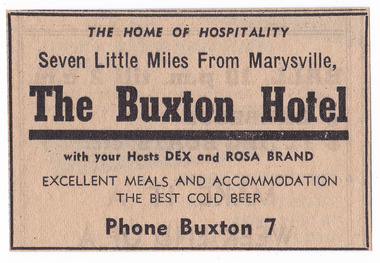
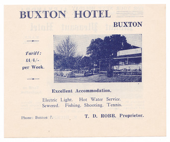
Newspaper (Item) - Newspaper advertisement, BUXTON HOTEL, 1950s
A newspaper advertisement regarding the Buxton Hotel in Buxton. Dex and Rosa Brand were the hosts at the hotel at the time of the advertisement. They, along with their children, Colin and Helen, ran the hotel in the 1950s. The Buxton Hotel was built by William Burchall, probably in the late 1870s. The first owner, who also had land locally, was Frederick Nichols (1833-1904). The Buxton Hotel is located directly opposite the General Store. It was fronted with two huge oak trees and bordered and backed by large pine trees. It was a weatherboard structure with a painted corrugated iron roof. Old split wood shingles were covered by corrugated iron, which overlaid the shingles to make the roof watertight. The wooden shingles date back to the 1850s.A newspaper advertisement regarding the Buxton Hotel in Buxton.buxton, victoria, australia, buxton hotel, accommodation, willam burchall, frederick nichols, advertisement, colin brand, helen brand, dex brand, rosa brand -
 Warrnambool and District Historical Society Inc.
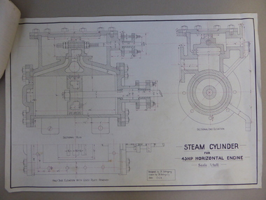
Document, Steam Cylinder Horizontal Engin, 1919
This drawing was produced by Ron Uebergang in 1919 at the Warrnambool Technical School. Members of the Uebergang families have been in the Warrnambool/Allansford area since the early 1850s. Ronald Uebergang (1903-1971) was born in Warrnambool, the son of Ernest Uebergang and Mary Watson. He lived at the family property, Hopkins Hill, and went to Allansford State School and Warrnambool Technical School. He was mechanically-minded, fond of music and dancing and a keen photographer. He married Myra Hall and they ran a dairy farm at Hopkins Hill and later went in for grazing beef cattle. Warrnambool Technical School was established in 1913, firstly at a Timor Street site and later at Caramut Road. Today it is called Brauer College. This drawing is of considerable interest as it was produced by Ron Uebergang. Members of the Uebergang families have been prominent in the Warrnambool/Allansford area since the early days of the district’s establishment. It is also important as a good example of the type of work produced by students from Warrnambool Technical School in its early years. This is a1919 drawing of a Steam Cylinder for a 45 HP Horizontal Engine. The drawing is half the full size of the cylinder. The drawing is on a white card with the sketches done in black and red ink. The card has a heavy black margin around the edges drawn in black ink. The drawing shows a Sectional Plan and a Half Side Elevation with the Cover Plate Removed. The card has the signature of Ron Uebergang. Attached by a metal clip to the card are four pages of measurements and plans of the steam cylinder. These are in black and red ink. Three of these pages have become partly detached. ‘Designed by R. Uebergang’ ‘Drawn by R. Uebergang’ ‘Date 1/12/19’ ronald uebergang, warrnambool technical school, history of allansford, history of warrnambool -
 Warrnambool and District Historical Society Inc.
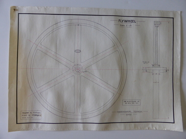
Drawing, Warrnambool Tech .1 Fly Wheel.2 Bevel Wheels R Uebergang, 1919
These drawings have been produced by Ron Uebergang at the Warrnambool Technical School in 1919. Uebergang family members were pioneer settlers in the Warrnambool area in the early 1850s. Ronald John Uebergang (1903-1971) was born in Warrnambool to Ernest Uebergang and Mary Watson. Ron Uebergang lived at the family property, Hopkins Hill at Allansford and went to Allansford State School and Warrnambool Technical School. He was mechanically minded, a good photographer and fond of music and dancing. He married Myra Hall and was a dairy farmer at Hopkins Hill and later grazed beef cattle. Warrnambool Technical School was established in 1913, firstly at a Timor Street site and later at Caramut Road (today it is known as Brauer College). These drawing are of considerable interest as works produced by Ron Uebergang. Uebergang family members have been prominent in the Warrnambool-Allansford area since the pioneering days of the district. The drawings also are good examples of the type of work produced by Warrnambool Technical School students in its early years.These are two designs and drawings by Ron Uebergang produced at the Warrnambool Technical School in 1919. They are drawn on white card using black and red ink. The scale of the Flywheel is three inches to one foot and the Bevel Wheels are one-third full size. The drawings are edged with heavy black lines. The two sheets have the signature of Ron Uebergang. There are also four pages of handwritten notes on the Flywheel and Bevel Wheels.‘Designed by R. Uebergang’ ‘Drawn by R.Uebergang’ ‘Date 4/1/19’ (on Flywheel sheet) ‘Date 27/5/19’ (on Bevel Wheels sheet) warrnambool technical school, ronald uebergang, history of allansford -
 Warrnambool and District Historical Society Inc.
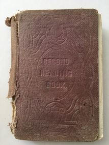
Book, Second Reading Book, 1876
This is a Reading Book of the Irish National Board of Education adapted for use in schools in Victoria, Australia. Irish School Readers were used in Victoria under the National School System in the 1850s and continued to be used in the 1860s and 70s under the Common School System and the introduction of the State School System after 1872. Readers produced in Victoria for Australian children did not become prominent until the 20th century (School Papers 1898 and Victorian Readers 1928). The signature of Hugh Adams in this book indicates that the book may have come from one of the Adams families farming in the Wangoom area near Warrnambool. There were several boys in these families named Hugh and it is unclear which one owned this book. This book is of interest as an early school reader used in the Warrnambool area and as a book belonging to a member of a local Adams family in the 19th century.This is a hard cover book of 285 pages. It has a brown cover with the title and ornamentation etched into the cover. The book contains prose extracts and poetry with the extracts headed by the derivation and pronunciation of some of the words in the text. There are a few illustrations and sketches. Some of the illustrations have been coloured and scribbled on. The book has been bound with string and glue with the lower portion of the spine cover missing. The book is very tattered. ‘Hugh Adams’ (back pages and on page 279) school readers, education in warrnambool, hugh adams -
 Kew Historical Society Inc
Photograph, Floods in North Kew, 1971
Living with natural processes was frequently a challenge to early European settlers and later residents of what was in the 1850s administered by the Borondara Road Board. This was compounded by the area being bounded on three sides by rivers (Yarra River, Koonung Creek and Gardiner's Creek). In 1849, the historian James Bonwick recorded that "our district [Kew] suffered considerably. Mr Wade speaks of 80 acres, out of 100 acres of his cultivated paddock, covered by water." Newspapers continued to describe major flooding in Kew in 1863, 1869, 1878, 1880, 1889, 1891, 1916 and 1934. While the construction of the Upper Yarra dam in 1957 reduced the levels of flowing downstream, local and riverine floods continue.The Kew Historical Society's pictures and map collections testify to the impact of flooding in the district. They have historical importance in documenting the extent of flooding in the district and its affects on homes, services and recreation. Numerous photographs record flooding throughout the Twentieth Century.Floods in North Kew, 1971. Looking northeast towards Kilby Road from River Avenue. Annotation on reverse: map and date "8 Nov. 71 10.30am".floods (kew), yarra river, kew flood, kilby road flood -
 Kew Historical Society Inc
Photograph, Floods in North Kew, 1934
Living with natural processes was frequently a challenge to early European settlers and later residents of what was in the 1850s administered by the Borondara Road Board. This was compounded by the area being bounded on three sides by rivers (Yarra River, Koonung Creek and Gardiner's Creek). In 1849, the historian James Bonwick recorded that "our district [Kew] suffered considerably. Mr Wade speaks of 80 acres, out of 100 acres of his cultivated paddock, covered by water." Newspapers continued to describe major flooding in Kew in 1863, 1869, 1878, 1880, 1889, 1891, 1916 and 1934. While the construction of the Upper Yarra dam in 1957 reduced the levels of flowing downstream, local and riverine floods continue.The Kew Historical Society's pictures and map collections testify to the impact of flooding in the district. They have historical importance in documenting the extent of flooding in the district and its affects on homes, services and recreation. Numerous photographs record flooding throughout the Twentieth Century.Floods in North Kew, 1934. Vicinity of Willsmere Park.floods (kew) -
![Flooding at Chipperfield's Boathouse [East Kew], 1934](/media/collectors/550653872162f11fb04854aa/items/58cbaad5d0cec425b474bfb1/item-media/58cf6fbdd0cf9f331490feb0/item-fit-380x285.jpg) Kew Historical Society Inc
Kew Historical Society IncPhotograph, Flooding at Chipperfield's Boathouse, 1934
Living with natural processes was frequently a challenge to early European settlers and later residents of what was in the 1850s administered by the Borondara Road Board. This was compounded by the area being bounded on three sides by rivers (Yarra River, Koonung Creek and Gardiner's Creek). In 1849, the historian James Bonwick recorded that "our district [Kew] suffered considerably. Mr Wade speaks of 80 acres, out of 100 acres of his cultivated paddock, covered by water." Newspapers continued to describe major flooding in Kew in 1863, 1869, 1878, 1880, 1889, 1891, 1916 and 1934. While the construction of the Upper Yarra dam in 1957 reduced the levels of flowing downstream, local and riverine floods continue.The Kew Historical Society's pictures and map collections testify to the impact of flooding in the district. They have historical importance in documenting the extent of flooding in the district and its affects on homes, services and recreation. Numerous photographs record flooding throughout the Twentieth Century.Floods in North Kew, 1934. Chipperfield's Boathouse and the adding Moorings was located beside the Yarra River near the corner of Willsmere and Kilby Roads. The flood reached the roof of the Moorings, which can be seen in the photo.floods (kew), floods (kew) 1934, yarra river -
 Kew Historical Society Inc
Photograph, Floods in North Kew, 1934
Living with natural processes was frequently a challenge to early European settlers and later residents of what was in the 1850s administered by the Borondara Road Board. This was compounded by the area being bounded on three sides by rivers (Yarra River, Koonung Creek and Gardiner's Creek). In 1849, the historian James Bonwick recorded that "our district [Kew] suffered considerably. Mr Wade speaks of 80 acres, out of 100 acres of his cultivated paddock, covered by water." Newspapers continued to describe major flooding in Kew in 1863, 1869, 1878, 1880, 1889, 1891, 1916 and 1934. While the construction of the Upper Yarra dam in 1957 reduced the levels of flowing downstream, local and riverine floods continue.The Kew Historical Society's pictures and map collections testify to the impact of flooding in the district. They have historical importance in documenting the extent of flooding in the district and its affects on homes, services and recreation. Numerous photographs record flooding throughout the Twentieth Century.Floods in North Kew, 1934. Unidentified location on the Yarra Flood Plain at Kew.floods (kew) 1934, yarra river -
 Kew Historical Society Inc
Photograph, Floods in North Kew, 1934
Living with natural processes was frequently a challenge to early European settlers and later residents of what was in the 1850s administered by the Borondara Road Board. This was compounded by the area being bounded on three sides by rivers (Yarra River, Koonung Creek and Gardiner's Creek). In 1849, the historian James Bonwick recorded that "our district [Kew] suffered considerably. Mr Wade speaks of 80 acres, out of 100 acres of his cultivated paddock, covered by water." Newspapers continued to describe major flooding in Kew in 1863, 1869, 1878, 1880, 1889, 1891, 1916 and 1934. While the construction of the Upper Yarra dam in 1957 reduced the levels of flowing downstream, local and riverine floods continue.The Kew Historical Society's pictures and map collections testify to the impact of flooding in the district. They have historical importance in documenting the extent of flooding in the district and its affects on homes, services and recreation. Numerous photographs record flooding throughout the Twentieth Century.Floods in North Kew, 1934. Chipperfield's Boat House under flood.floods (kew) 1934, yarra river, chipperfield's boat house -
 Kew Historical Society Inc
Photograph, Floods in North Kew, 1934
Living with natural processes was frequently a challenge to early European settlers and later residents of what was in the 1850s administered by the Borondara Road Board. This was compounded by the area being bounded on three sides by rivers (Yarra River, Koonung Creek and Gardiner's Creek). In 1849, the historian James Bonwick recorded that "our district [Kew] suffered considerably. Mr Wade speaks of 80 acres, out of 100 acres of his cultivated paddock, covered by water." Newspapers continued to describe major flooding in Kew in 1863, 1869, 1878, 1880, 1889, 1891, 1916 and 1934. While the construction of the Upper Yarra dam in 1957 reduced the levels of flowing downstream, local and riverine floods continue.The Kew Historical Society's pictures and map collections testify to the impact of flooding in the district. They have historical importance in documenting the extent of flooding in the district and its affects on homes, services and recreation. Numerous photographs record flooding throughout the Twentieth Century.Floods in North Kew, 1934. Flood near the lagoon (Billabong?)floods (kew) 1934, yarra river -
 Kew Historical Society Inc
Photograph - Studley Park, 1937
Those sections of Studley Park closest to the River Yarra were set aside as parkland in the 1850s. After initial discussions about whether it was a suitable site for a Government House, much of the land was instead gazetted in the 1860s as the location for a new lunatic asylum, to expand overcrowded mental health facilities at the Yarra Bend Asylum on the other side of the river at Fairfield. Those sections of Studley Park bounded by the Yarra River, Studley Park Road, Princess Street and Fellows Street were subdivided and sold at the Crown Land Sales in 1851. Much of this urban area remained open farmland until the twentieth century, apart from mansions, largely located along the main roads.Original, black and white positive print of what is said to represent Studley Park in 1937. If the attribution and date is literally to be understood, then it would appear that the photograph may have been taken from the Kew side of the river looking across to open farmland in the Yarra Bend Park. If the designation of Studley Park is to be understood more loosely, then it might be a view of what is now East Kew, taken from a section of Kilby Road. Inscribed verso: "Studley Park 1937" studley park -- kew (vic.) -
 Wodonga & District Historical Society Inc
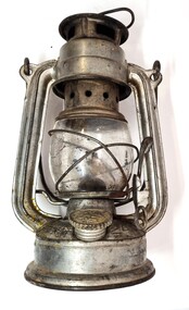
Domestic object - Kerosene Lantern
During the Victorian goldrushes of the 1850s thousands of Chinese migrants arrived to seek their fortunes. At that time many came to the lucrative gold fields of Northeast Victoria. After the Gold rush, many Chinese migrants returned home. However, a number settled in the area as merchants, hawkers and market gardeners in surrounding towns including Wodonga, the Ovens, King, Buffalo River and Kiewa Valleys. They also rented lands and established themselves in the hops and tobacco farming industries. Items of Chinese origin made their way into many households. Importation of Chinese mass produced items such as this lantern continued well into the 20th century and were common domestic items across Australia before households were connected to electricity.This item is representation of kerosene / paraffin lamps used throughout Australia to provide lighting inside and outdoors prior to the widespread availability of electricity.A small hurricane lamp with a rounded tank and small carry handle attached to the top. A larger handle is also attached at the top of the frame. It has a lever to open the glass tank. It has a metal base which is filled with kerosene. It has a screw knob to open the kerosene receptacle. The metal hood also has vents. The Chinese characters around the base translate to "Shanghai Guanghuaheng".Around base : Chinese characters. On top : "Made in China KWANG HWA"kerosene lamp, domestic appliances, chinese artefacts -
 Warrnambool and District Historical Society Inc.
Document (item) - Allansford land purchase document, Land purchase document, 1864
This paper contains details of the purchase of Lot 11 in the Township of Allansford in 1864. The purchaser, Isabella McQueen, was born in Scotland in 1814, married Alexander McQueen in 1850 and with her family migrated to Australia in 1854. After her husband's death in 1860 Isabella purchased the land in Frank Street, Allansford in 1864 and lived in a house there with family members until her death in 1895. She had purchased the land, via an agent, from John Allan who with his brothers were the pioneer European settlers in the Allansford area. John Allan had created the township of Allansford in the mid 1850s by sub-dividing the land he owned there. John Allan moved to the Gippsland area late in 1864. This piece of paper is most significant as it is an original record of an early transaction in the history of Allansford, a town now part of Warrnambool City.Mrs isabella McQueen Bot. of Robert Gregory As agent for J M Allan Esq. Lot no. 11 as marked and described on the Plan of Subdivision of the Township of Allansford. For which I have received the um of five pounds Stg. being the purchase money of same. Robert Gregory 21st October 1864allansford history, john allan, isabella mcqueen -
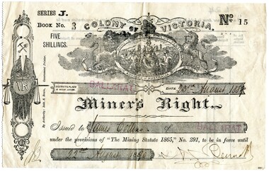 Flagstaff Hill Maritime Museum and Village
Ephemera - Miner's Right - Collins, 1888
This Miner’s Right was issued post the rush of the 1850s-60s but is testament to the ongoing interest in gold although the great rush had dwindled. Local papers continued to report on findings and hopes of success, including syndicates and explorations across the south-west district of Victoria and Otways. The Warrnambool correspondent of the “Hamilton Spectator”, 31/1/1878, p4 attest to the price of a good season of potatoes comparing “favourably with the unsteady returns of any precarious gold-bearing quartz reefs in the colony.” A James Collins (1842-1918) is listed in the Pioneers’ Register, Warrnambool, Township and Shire 1839-1900, Volume One, A.I.G.S Warrnambool Branch, 2004, p137. As are numerous other Collins pioneer families of the district. This item is significant in that it illustrates that people associated with the region were interested in taking their chances in prospecting for gold similar to many others. A lure that is still present for some today. Although the southwest region found it's source of wealth in other industries from whaling and fishing, wool and other agricultural pursuits. This is a top to bottom upright image of a Miner’s Right. It is a buff coloured document printed in black ink. It was issued in “BALLARAT” and rubber stamped twice in red ink. The issue to “James Collins”, is dated “23rd August 1889” to “22nd August 1890”. The signature of the authority could be Bennet. All handwriting is script style in black ink. Looking from the front the lefthand side has a serrated edge. The back is printed in black ink and there are no “particulars of registration”. The Miner’s Right is from “Series J, Book No. 3, ticket “No. 15”. A “Colony of Victoria” coat of arms is displayed at the top of the document. An insignia runs along the lefthand side of the license featuring coat of arms with a kangaroo and emu, then a miner’s pick and shovel, two crossed Union Jack flags sit behind a monogram “VR” with a hanging set of scales supported by a sword. "By Authority Robt. S. Brain, Government Printer.""Series J. Book No. 3 Five Shillings. No. 15. Colony of Victoria. Miner's Right"flagstaff hill, warrnambool, shipwrecked coast, flagstaff hill maritime museum, maritime museum, shipwreck coast, flagstaff hill maritime village, great ocean road, james collins, australian goldfields, miner's rights, the history of ballarat, gold rush -
 Halls Gap & Grampians Historical Society
Map - Coloured
Background on Bridle Path up Stony Creek Gorge Pre 1840 C. B. Hall, squatter on Mokepilly Run 1841-1842, first European to discover the Fyans Creek valley, the entrance of which became known as Hall's Gap. He later recorded that he followed a number of tracks which he assumed had been made by the Aboriginies and described one as "leading up a wild romantic glen and over on to the source of the Glenelg River". This could well have been the route taken up Stony Creek gorge by the first timber-cutters in this part of the Grampians to the saddle between the Wonderland and Mt. Difficult ranges known as Valley Gap 1850s/60s Timber cutters and shingle splitters were reported to be moving into the eastern side of the Grampians and by the mid 1860s there were a number of families connected to the supplying of timber to Pleasant Creek living in the "Hall's Gap ranges". John Wakeham, the first store owner in Pleasant Creek in 1854, established a timer-mill in upper Stony Creek Gorge in the late 1850s. Wakeham is credited for the clearing and levelling of the first bridle-path up the gorge. 1870s By the mid 1870s the track had been extended over Valley Gap to the Victoria Forest (the upper region of the Victoria Valley). McKeon's bullock team was known to have hauled red gum from the Valley to Stawell in the late 1870s and the 1880s. 1880s In 1887 an article in the Pleasant Creek news describes the Stony Creek Gorge track as "being a ledge alongside the mountain range, formed in the early days with the aid of earth and timber, along which the bullock teams used to travel to Horsham and plains of the Wimmera beyond." 1890s Gold was discovered in the catchment area of Stony Creek and by the end of the 1890s a new track was built from "near the junction of Fyan's and Stony Creeks, up the gorge to the diggings settlement. The mining Department had paid L300 for its construction and, when completed, the track was "three miles and 30 chains in length, the side cuttings at the narrowest part being 10 feet between" and "the watercourses which cross the track at various points" having been "filled up with rocks rolled down the sides of the hills, and consequently there can be no damage caused by bushfires which destroyed the former wooden bridges erected on the old track to Wakeham's saw-mill, the remains of which are still to be seen at the side of the diggings" The article goes on to further describe the track as one which "can with ease travel with a two horse conveyance either up or down" and that the workmen engaged in the construction of the track would be attending "a ball that night at McKeon's farm near the mouth of the gap to celebrate the successful completion of the undertaking". 1900s At what time the bridle path was extended beyond Valley Gap to the Wartook basin on the Mt. Difficult Range has not yet been determined. However, it is known that, by the turn of the century, people were travelling between Halls Gap and the caretakers' residence at Wartook Reservoir along what was now known as the "Bluff Road. Wartook's embankment had been constructed in 1887 and at that time there was already a track from Rosebrook Station homestead (near the present day Wartook Pottery) to the reservoir. Philip Rose owned both Rosebrook and Wartook Stations from the mid 1840s to the late 1850s and had regularly leased the Wartook basin to Cobb & Co. to rest horses there. 1920s Following the war of 1914-1918, tourism really took off in the Grampians, and Halls Gap rapidly grew. People would travel as far as they could on the many tracks then hike to the many lookouts being discovered by local tour guides. This led to the need for access across the range so that horse riders and the increasing number of vehicles could travel between Horsham and Halls Gap. To this end, the Bluff Road was improved and extended on 1929 and at its opening in March, 1930, by Lady Somers it was renamed the Mt. Victory Road.Map of Mt Victory Road and othersaccess routes, mt victory rd, bridle path, roads -
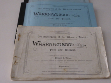 Warrnambool and District Historical Society Inc.
Booklet, W'bool Past & Present Edward Vidler, 1907
This book was written and produced by Edward Vidler, Born in England, Edward Vider, a writer, publisher, journalist and editor, was in Geelong in the 1880s where he produce a commemorative volume of that city. In Warrnambool in the early 1900s Vidler was Secretary of the Warrnambool Chamber of Commerce and Manufactures and of the Warrnambool and District Progress League. In 1907 he produced ‘Warrnambool Past and Present’ to celebrate the 60th anniversary of the founding of Warrnambool. In 1907 he also organized the project that produced the Warrnambool Pioneer Honour Board. Later Vidler lived in Melbourne where he edited magazines and published his own and other writings. He was interested in the promotion of the arts and was a keen naturalist. He was a foundation member of the group that established the Maranoa Native Gardens in Balwyn.These books are of the utmost significance as ‘Warrnambool Past and Present’ is a seminal work in the history of the Warrnambool – second only in importance to Richard Osburne’s History of Warrnambool published in 1887. ‘Warrnambool Past and Present’ is noted for the accuracy of Vidler’s research, its complementary value to Osborne’s history and its presentation of historically valuable material that might otherwise be lost. The photographs in the book are of excellent quality and of great historical value and continue to be scanned and copied today. Intact original copies of this book are very rare today.These are five copies of ‘Warrnambool Past and Present – 88 pages, text by Edward Vidler, 120 black and white photographs and illustrations, local advertisements, original soft cover is missing in all copies. .1 Full original text with letter insert from donor and blue cardboard cover with plastic overlay and black binding .2 Full original copy with added index and soft cover with plastic overlay and red binding .3 Original text to page 76 with added photocopied pages and blue cardboard cover .4 Original text to page 72 and added photocopied pages and no cover with staple binding and some adhesive tape, tattered first and last pages .5 Original text to page 80, added photocopied pages and no cover and no binding .1 Letter from Margaret Wright, Queenscliffe Historical Society .3. ‘S. Wickham’ history of warrnambool, edward vidler, pioneer honour board -
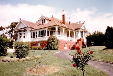 Surrey Hills Historical Society Collection
Photograph, Mr A Noack, Emilia Villa, 4 Albany Crescent, Surrey Hills, 1984
The house was built in 1913 for Mr James Rubira and named for his wife Emilia Tajouera Guidotti, an Italian opera singer. She was born in 1865 and died in Surrey Hills on 21 October 1950. James was born in 1863 in Allela, Barcelona, Catalonia, Spain and died on 8 November 1935 in Surrey Hills. They married in Victoria in 1892. They married in 1892. James's mother was a member of the Parer family. The Rubiras and the Parers were among a number of Spanish families who began to migrate to Australia in the 1860s. James' mother was Teresa Florentina Lluisa Parer. Many of the families settled in Box Hill and then Surrey Hills by the 1900s. The Rubiras and the Parers established and supplied a number of high-class restaurants and hotels in Melbourne.Coloured image of an Edwardian style brick house at 4 Albany Crescent, Surrey Hills. It shows the path up to the house with the garden on each side. There is a fountain in the garden on the LHS of the path.On rear in blue pen: "Mr Rubira's House / per / A Noack (underlined) / Albany Cres"emilia villa, house names, 1913, singers, spanish community, italian community, ethnic communities, parer family, albany crescent, surrey hills, restaurants, hotels, edwardian style, mr james rubira, mrs emilia rubira, miss emilia tajouera guidotti -
 Melton City Libraries
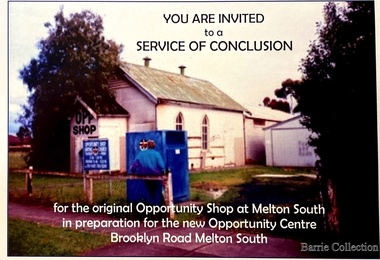
Flyer, Melton South Uniting Church Opportunity Centre, 2016
The Opportunity Shop – Established 1975 by Edna Barrie 1992 In 1985 the need for more shop space became apparent. Les [Bone] had plans drawn up (Surv 12/8/84) and approved by the Melton shire Council for a storeroom extension (17.800 x 9500) 1986 the small ancillary rooms at the rear of the timber church were demolished allowing the concrete slab to be laid. The building was completed in 1987. By the early 1900s the old timber Church had deteriorated, this lead to it being demolished in 2/11/1993. It was replaced with a new building containing a Pastoral Office, a meeting room and a furniture and homeware section. It was dedicated by Rev Ian Hickingbotham at 11am Sunday 5th June 1994. Invites to the service of conclusion of the original Uniting Church Opportunity Centre and official opening to the new shop in Melton Southchurches, local identities -
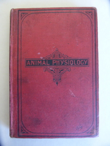 Warrnambool and District Historical Society Inc.
Book, Animal Physiology, Late 19th century
This book is a text book for senior students used at St. Joseph’s School, Warrnambool in 1891. A Catholic School was first established in Warrnambool in Kelp Street in the 1850s and later this school became Common School Number 680 situated in Kepler Street. This school was known as St. Joseph’s School after 1876 and was re-located to Lava Street in 1935. Today St. Joseph’s Primary School is located in Botanic Road, Warrnambool. The Kepler Street school building that would have been the one Minnie Beatie attended is still existing No confirmed information has been found on Minnie Beatie but there was a Mary Beatie who was born in Warrnambool in 1875 to Michael and Margaret Beatie and this may be Minnie who owned the text book. This book is of interest as an example of a science text book used in Warrnambool in the late 19th century. It is associated specifically with St. Joseph’s Catholic School, Warrnambool and with Minnie Beatie. This is a hard cover book of 144 pages. It has a red cover with red lettering on a black background on the front cover and black lettering on the spine. Inside the front and back covers is information on other books published by Blackie and Son. There are two pages of colour illustrations and many black and white illustrations. The cover is a little stained. The inscriptions are handwritten in blue ink. ‘Minnie Beattie St Josephs School Warrnambool 1891’ st. joseph’s catholic school, warrnambool, minnie beattie, animal physiology -
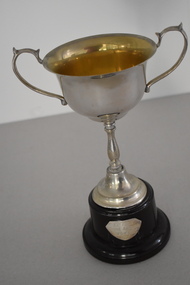 Warrnambool and District Historical Society Inc.
Trophy, ICISA Grand aggregate 1937, 1937
This trophy is one of several awarded in the 1930s by the Inter Church Indoor Sports Association in Warrnambool. It is a grand aggregate cup and it has been won jointly by the Congregational Men’s Institute (C.M.I.) and the Church of England Men’s Society (C.E.M.S.). Both of these men’s groups were prominent in the 1930s. A Congregational Church was opened in Liebig Street, Warrnambool in 1864 and transferred to Henna Street in 1940. This Henna Street church was sold to the Salvation Army in 1979 when the Congregational Church and the Methodist Church merged to form the Uniting Church. The Anglican Church in Warrnambool, called Christ Church, was established in Henna Street in the 1850s under the direction of the first minister, Archdeacon Beamish. The present church was constructed over the ensuing decades with the square tower added in 1882. This trophy is of interest as it comes from the 1930s and is one of the trophies given by the now-defunct Inter Church Indoor Sports Association of Warrnambool. It also has connections to both the Congregational Church and the Anglican Church in Warrnambool. This is an electro plated nickel silver cup with two side handles and an ornate stem attached to a silver base. The cup is mounted on a circular Bakelite stand. The stand has a small silver plaque with an inscription.‘I.C.I.S.A. Grand Aggregate C.M.I. & C.E.M.S. 1937’ anglican church warrnambool, congregational church warrnambool, inter church indoor sports association warrnambool -
 Warrnambool and District Historical Society Inc.
Books, A & C. Black Ltd, 1927
This book was a prize given by Warrnambool Technical School in 1934. Warrnambool Technical School was established in Timor Street in 1913. John King, whose name appears on the book plate of this book, was the first head teacher and remained in this position for 29 years. In 1972 the Technical School was moved to Caramut Road, Warrnambool and in 1989 the school was renamed Brauer College. The old Technical School site in Timor Street now houses the South West Institute of TAFE. The book was donated by William Reed who had a bookstore and newsagency in Timor Street at the time. The book was given to Winnie Ferrier. Members of the Ferrier family have been in the South Warrnambool area since the 1850s and the 19th century Ferrier families were associated with Warrnambool port activities. This book is retained as a memento of the Warrnambool Technical School in the 1930s with its references to John King, the foundation Principal, the donor of the book, William Reed, a Warrnambool businessman and the recipient of the book, Winnie Ferrier, with the name Ferrier well-known in South Warrnambool in both the 19th and the 20th centuries. This is a hard cover book of 204 pages. The front cover has a beige background with a blue and brown patterning and brown printing. The spine has similar patterning with gold printing and the back cover is beige. The book has 15 chapters, an index, some pages of advertisements for other books and several colour plates. The first page has a book plate pasted in. Warrnambool Technical School Labor to Efficiency 19th December 1934 for Lettering, Dressmaking A3 Donated by William Reed Esq. Awarded to Winnie Ferrier John King Principal warrnambool technical school, reed’s newsagency,, history of warrnambool -
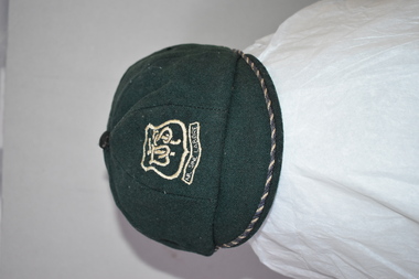 Warrnambool and District Historical Society Inc.
Hat, School W'bool High School, Early 1930s
This is a Warrnambool High School cap from the 1930s. Warrnambool High School was established in 1907 with a farm site in Merrivale and it was also in several sites in the main town area, with the longest occupancy in Hyland Street. In 1961 the school moved to its present location in Albert Park (Grafton Road). The High School amalgamated with Warrnambool North Technical School in 1995 to form Warrnambool College. Malcolm Goodall, the owner of the cap, was born in 1917 and died in 2010. He lived in Coulstock Street and he worked in the tinning department of Nestles. The Goodall family has been in the Warrnambool area since the mid 1850s including being at the farm, ‘Wanstead’ in East Warrnambool and at Framlingham in the 19th century where William Goodall was the manager of the aboriginal settlement. This cap is of interest as an example of the boys’ uniform at Warrnambool High School in the 1930s and as a memento of Malcolm Goodall. His ancestors were pioneers in the Warrnambool district.This is a boy’s cap made of dark green cloth with octagonal sections and a cloth button on top. The peak is edged with navy and cream cord. The centre front of the cap has a school badge with the school initials and motto. The inside of the cap is lined with black cloth with a cream centre and has the cap seller’s business details and the name of the owner of the cap. Some of the printed material here is indecipherable. The stitching is worn in some places. W.H.S. Sine Labore V. Becker Boys Shop & Hosiery Parlour Warrnambool Name: M. Goodall warrnambool high school, goodall family, history of warrnambool -
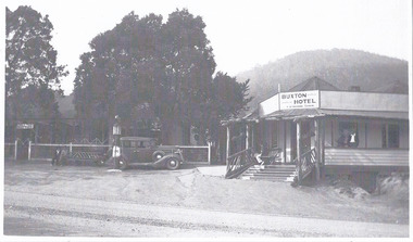 Marysville & District Historical Society
Photograph (Item) - Black and white photograph, Unknown
A black and white photograph of the Buxton Hotel in Buxton. Thomas David Robb (1886-1967), was the licensee at the time of the photograph. He, and his wife Alice May Evans, ran the Buxton Hotel for 25 years. The Buxton Hotel was built by William Burchall, probably in the late 1870s. The first owner, who also had land locally, was Frederick Nichols (1833-1904). The Buxton Hotel is located directly opposite the General Store. It was fronted with two huge oak trees and bordered and backed by large pine trees. It was a weatherboard structure with a painted corrugated iron roof. Old split wood shingles were covered by corrugated iron, which overlaid the shingles to make the roof watertight. The wooden shingles date back to the 1850s.A black and white photograph of the Buxton Hotel in Buxton.buxton, victoria, australia, buxton hotel, accommodation, photograph, william burchall, frederick nichols, alice may evans, thomas david robb -
 Marysville & District Historical Society
Ephemera (Item) - Advertisement, BUXTON HOTEL, Unknown
An advertisement regarding the Buxton Hotel in Buxton. Thomas David Robb (1886-1967), was the licensee at the time of the photograph. He, and his wife Alice May Evans, ran the Buxton Hotel for 25 years. The Buxton Hotel was built by William Burchall, probably in the late 1870s. The first owner, who also had land locally, was Frederick Nichols (1833-1904). The Buxton Hotel is located directly opposite the General Store. It was fronted with two huge oak trees and bordered and backed by large pine trees. It was a weatherboard structure with a painted corrugated iron roof. Old split wood shingles were covered by corrugated iron, which overlaid the shingles to make the roof watertight. The wooden shingles date back to the 1850s.An advertisement regarding the Buxton Hotel in Buxton.buxton, victoria, australia, buxton hotel, thomas david robb, alice may evans, accommodation, willam burchall, frederick nichols, advertisement -
 Queenscliffe Maritime Museum
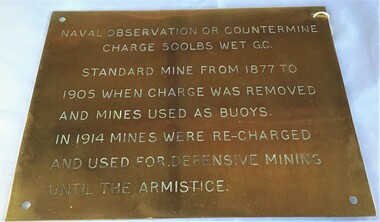
Plaque - Plaque, brass inscribed with Naval countermine information
Found in garden shed of Mr Harry Barratt [WWI Gallipoli] and donated by his grandson. In 1877 Swan island was designed to defend shipping in Port Phillip and Hobson's Bays. The scheme, involving massive expenditure, comprised a forward defence system of forts at Port Phillip heads dominated by Fort Queenscliff and South Channel Fort (artificial island), and a network of coastal batteries. Some development of fortification had occurred in the 1850s, but it was the impetus of the Jervois-Scratchley reports which led to major work being undertaken in the 1880s. The overall defence plan involved a combination of guns, mines (known as electric torpedo) and ships to defend the entrance to Port Phillip Bay. Swan Island Fort would be used to protect the minefields in the harbour, Naval observation countermine charge 500lbs wet G.C Standard mine from 1877 to 1905 when charge was removed and mines used as buoys. In 1914 mines were recharged and used for defensive mining until Armistice.Brass plaque inscribed with information on naval countermineNaval observation or countermine charge 500lbs wet G.C. Standard mine from 1877 to 1905 when charge was removed and mines used as buoys. In 1914 mines were recharged and used for defensive mining until the Armistice.sea mine, plaque, pre wwi, naval countermine, swan island -
 Kew Historical Society Inc
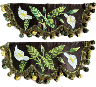
Decorative object - Pair of hand embroidered pelmets
This item is part of a larger collection donated to the Kew Historical Society by Anna French. The collection includes personal items from the donor's family, as well as items given to the donor and her mother by a family friend, Lucy Merritt (Jean) Hornby. The item is from that part of the collection inherited or assembled by Jean Hornby. The collection is significant given Jean Hornby's mother's descent from Robert Hornby (1854-1935) and Eva Merritt (1865-1959); her mother the chid of a family who settled in Kew in the 1850s, this providing a chain of provenance for items dating to the mid-nineteenth century, when her maternal forebears arrived in Melbourne. Other items represent Jean Hornby's contribution to her local and wider community.The items as created are representative and fine examples of late Victorian and or Edwardian needlework. While many such items were copies of published patterns, these may be original designs. Two mantle or pelmet decorations, with hand embroidered arum lilies on delustred satin backed onto canvas. One pelmet is slightly longer than the other, but each has the same number of bobbles on the trim. hornby family, families -- kew (vic.), jean hornby, soft furnishings, decorative arts, embroidery -
 Kew Historical Society Inc
Photograph - Royal Hotel, Sunbury, C.H.R. Christianson, 1890s
This item is part of a larger collection donated to the Kew Historical Society by Anna French. The collection includes personal items from the donor's family, as well as items given to the donor and her mother by a family friend, Lucy Merritt (Jean) Hornby. The item is from that part of the collection inherited or assembled by Jean Hornby. The collection is significant given Jean Hornby's mother's descent from Robert Hornby (1854-1935) and Eva Merritt (1865-1959); her mother the chid of a family who settled in Kew in the 1850s, this providing a chain of provenance for items dating to the mid-nineteenth century, when her maternal forebears arrived in Melbourne. Other items represent Jean Hornby's contribution to her local and wider community.This 19th century photograph includes significant architectural details of an important hotel in Sunbury, Victoria. Additionally, it was taken by a local photographer - CHR Christianson - who operated the Sunbury [photographic] Studio. Silver albumen print, mounted on board, of the original Royal Hotel on the corner of Brook and Evans Streets, Sunbury, Victoria.The single-storey, rendered brick building with a corrugated galvanised iron roof includes a number of pieces of information that may assist in dating the photograph. The licensee's name above the door appears to be M.A. Williams. To the left of the door on the external wall is a painted sign: 'BILLIARDS". Another painted sign on the front of the building reads "ROYAL HOTEL [illegible] BILLIARDS." An attached building at right may be the residence of the licensee. Specific architectural features of the building include a corner doorway with a lamp above, three sash windows and a larger square lead-light window to the right of the doorway. The latter identifies the space behind as the "BAR". On the footpath in front of this building is a grill set into the footpath to enable deliveries to a cellar. At least four figures can be identified in the photograph: a woman in the doorway, a man to her right, leaning against the wall, and two other men at the right hand side of the building. Beyond the boundary of the building is a sloping footpath to a bluestone edged gutter. An elm [sic] within a protective, picketed surround is in front of the building. C.H.R. Christianson is identified on the reverse as the photographer. Reverse in pencil: Royal Hotel Billards Sunbury / CHR Christianson photographerroyal hotel -- sunbury (vic.), chr christianson -- photographer, hotels -- sunbury (vic.), recreation -- billiards