Showing 1323 items
matching streets - kew (vic)
-
 Kew Historical Society Inc
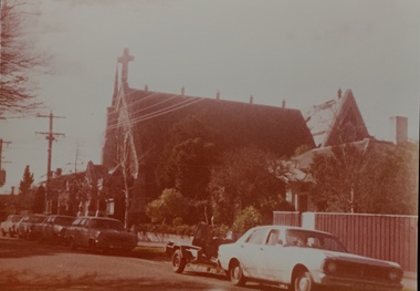
Photograph - Kew Congregational Church, Walpole Street, 1978
... walpole street -- kew (vic.)... churches -- kew (vic.) walpole street -- kew (vic.) congregational ...The site of the former Kew Congregational Church was the earliest 'built' place of religion in Kew. An earlier building by Charles Vickers was replaced by a new brick church designed by Albert Purchas. Following the creation of the Uniting Church, the church at 30 Walpole Street was declared redundant and demolished to make way for the Bodalla Nursing Home (itself later demolished).Faded colour photograph of the Kew Congregational Church in Walpole Street (Dem. 1978/9). "KH-137 / Former Congregational Church"kew congregational church, architects -- albert purchas, churches -- kew (vic.), walpole street -- kew (vic.), congregational churches -- melbourne (vic.) -
 Kew Historical Society Inc
Photograph - Street Works, Studley Park Road, March 1934
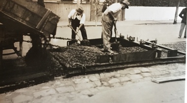
... street works -- kew (vic.)... -- kew (vic.) street works -- kew (vic.) public works kew (vic ...Studley Park Road, like most streets in Kew, was originally a dirt road. Street works during the Great Depression included bituminising major roads in the district. This photograph of Council works originated in the City of Kew Engineers Department as a record of works undertaken. It was given to the collection by a Mrs Fisher in 1998.Well provenanced photograph of Council-funded public works in Kew during the Great Depression. Original sepia monochrome positive of Council workers spreading bitumen in Studley Park Road, Kew.Typed reverse: "B4 / Kew C.C. / Spreading premixed material on Studley Park Road with drag spreader, March 1934"roadworks -- kew (vic.), street works -- kew (vic.), public works kew (vic.), studley park road -- kew (vic.), city of kew -- engineers department, city of kew -- public works -- great depression -- 1930s -
 Kew Historical Society Inc
Photograph - Street Works, Studley Park Road, March 1934
... street works -- kew (vic.)... -- kew (vic.) street works -- kew (vic.) public works kew (vic ...Studley Park Road, like most streets in Kew, was originally a dirt road. Street works during the Great Depression included bituminising major roads in the district. This photograph of Council works originated in the City of Kew Engineers Department as a record of works undertaken. It was given to the collection by a Mrs Fisher in 1998.Well provenanced photograph of Council-funded public works in Kew during the Great Depression. Original sepia monochrome positive of Studley Park Road, Kew.Typed reverse: "B4 / Kew C.C. / Studley Park Road after surfacing with one coat of premixed material spread with drag, March 1934"roadworks -- kew (vic.), street works -- kew (vic.), public works kew (vic.), studley park road -- kew (vic.), city of kew -- engineers department, city of kew -- public works -- great depression -- 1930s -
 Kew Historical Society Inc
Photograph - Street Works, Studley Park Road, March 1934
... street works -- kew (vic.)... -- kew (vic.) street works -- kew (vic.) public works kew (vic ...Studley Park Road, like most streets in Kew, was originally a dirt road. Street works during the Great Depression included bituminising major roads in the district. This photograph of Council works originated in the City of Kew Engineers Department as a record of works undertaken. It was given to the collection by a Mrs Fisher in 1998.Well provenanced photograph of Council-funded public works in Kew during the Great Depression. Original sepia monochrome positive of Council workers standing on and beside a dray in Studley Park Road, Kew while resurfacing of the street was taking place. The Kew Junction is just visible behind the men.Typed reverse: "B4 / Kew C.C. / Spreading premixed material on Studley Park Road with drag spreader, view from rear of machine, March 1934"roadworks -- kew (vic.), street works -- kew (vic.), public works kew (vic.), studley park road -- kew (vic.), city of kew -- engineers department, city of kew -- public works -- great depression -- 1930s -
 Kew Historical Society Inc
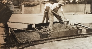
Photograph - Street Works, Studley Park Road, March 1934
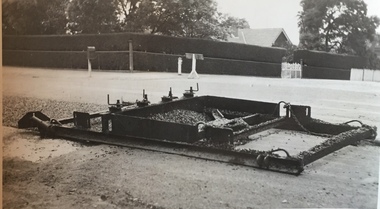
... street works -- kew (vic.)... -- kew (vic.) street works -- kew (vic.) public works kew (vic ...Studley Park Road, like most streets in Kew, was originally a dirt road. Street works during the Great Depression included bituminising major roads in the district. This photograph of Council works originated in the City of Kew Engineers Department as a record of works undertaken. It was given to the collection by a Mrs Fisher in 1998.Well provenanced photograph of Council-funded public works in Kew during the Great Depression. Original sepia photographic positive of a drag used to spread bitumen in Studley Park Road, Kew.Typed reverse: "B4 / Kew C.C. / Drag spreader used for premixed material on Studley Park Road, showing end of strip just with spread, with unsurfaced work on left and completed section on right, March 1934"roadworks -- kew (vic.), street works -- kew (vic.), public works kew (vic.), studley park road -- kew (vic.), city of kew -- engineers department, city of kew -- public works -- great depression -- 1930s -
 Kew Historical Society Inc
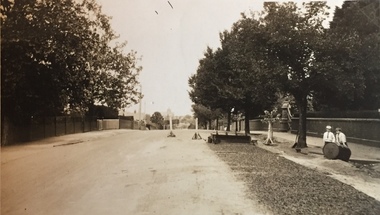
Photograph - Street Works, Studley Park Road, March 1934
... street works -- kew (vic.)... -- kew (vic.) street works -- kew (vic.) public works kew (vic ...Studley Park Road, like most streets in Kew, was originally a dirt road. Street works during the Great Depression included bituminising major roads in the district. This photograph of Council works originated in the City of Kew Engineers Department as a record of works undertaken. It was given to the collection by a Mrs Fisher in 1998.Well provenanced photograph of Council-funded public works in Kew during the Great Depression. Original sepia photographic positive of Studley Park Road, Kew while resurfacing of the street was taking place. The Kew Junction is just visible in the distance. Boys sitting on a drum at right. Behind them is the brick fence and front entrance to Tara Hall.Typed reverse: "B4 / Kew C.C. / Studley Park Road showing drag spread surfacing with premixed material, unrolled material on the right, March 1934"roadworks -- kew (vic.), street works -- kew (vic.), public works kew (vic.), studley park road -- kew (vic.), city of kew -- engineers department, city of kew -- public works -- great depression -- 1930s -
 Kew Historical Society Inc
Photograph - Street Works, Studley Park Road, March 1934
... street works -- kew (vic.)... -- kew (vic.) street works -- kew (vic.) public works kew (vic ...Studley Park Road, like most streets in Kew, was originally a dirt road. Street works during the Great Depression included bituminising major roads in the district. This photograph of Council works originated in the City of Kew Engineers Department as a record of works undertaken. It was given to the collection by a Mrs Fisher in 1998.Well provenanced photograph of Council-funded public works in Kew during the Great Depression. Original sepia photographic positive of Studley Park Road, Kew while resurfacing of the street was taking place. Typed reverse: "B4 / Kew C.C. / Spreading premixed material on Studley Park Road with drag spreader, March 1934"roadworks -- kew (vic.), street works -- kew (vic.), public works kew (vic.), studley park road -- kew (vic.), city of kew -- engineers department, city of kew -- public works -- great depression -- 1930s -
 Kew Historical Society Inc
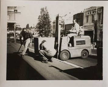
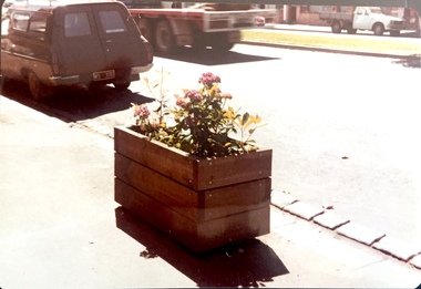
Photograph - Street Beautification: High Street, 1980s
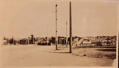
The City Engineer's Department within the former City of Kew, was responsible for public works, including in this instance, street beautification.Kew City Council workers installing planter boxes in High Street, Kew. Junction in distance at left.street beautification, city of kew -- engineers department, public works -- kew (vic.) -
 Kew Historical Society Inc
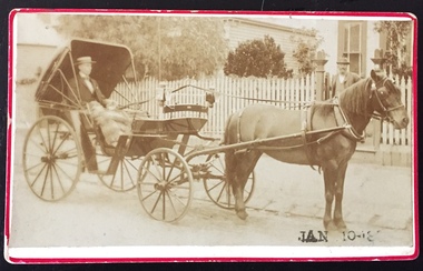
Photograph - John Watson, 1898
John Watson, and his son Albert John Watson, were butchers in High Street, Kew.They were the grandfather and father of the donor, Mrs Joy Ivory. John Watson Snr was a Steward of the Kew Methodist Church for 22 years.Small sepia photographic positive showing John Watson Snr standing at the gate of his house. In front of his house, an unidentified man is sitting in a horse and buggy. John Watson was a local butcher and a longstanding steward of the Highbury Grove Methodist Church."John Watson senior at gate. Butchers High Street Kew. Albert John Watson January 10th 1898 / John Bee, Avonville, Albert Street, Kew"john watson, butchers -- kew (vic.) -
 Kew Historical Society Inc
Photograph - High Street, Kew East, 1916
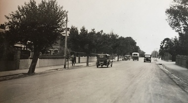
In 1980, Mr Laurie Bennett presented the Kew Historical Society with a number of photographs and postcards from the estate of his mother Eileen Mary Bennett (nee Clark). His mother was the daughter of Lawrence FH Clark(?-1946) and Mary Clark (?-1925) of 22 Harp Road, East Kew, in whose yard the photograph was taken. A year before the donation occurred a notice appeared in the Canberra Times stating that: "BENNETT, Eileen Mary. — May 8th at Tuross Heads, N.S.W. Late of 22 Harp Rd, East Kew, (Vic). Dearly loved wife of the late Harold Bennett, loved mother and mother in law of Laurie and Shirley (Melbourne), Kevin and Doreen (Canberra), grandmother of Linda, Stephen, Paul, Gabrielle, Peter, Mark and Jon."Part of a large collection of photographs and postcards in the collection. This dated photograph allows the researcher to identify development by 1916 in Kew and East Kew.High Street, Kew East in 1916 looking west. "High Street, East kew, near rail bridge."laurie bennett, eileen mary bennett, eileen mary clark -
 Kew Historical Society Inc
Photograph - Burgess House, Victoria Street (Abbotsford), 1880-1900
Major floods recurred of the Yarra River on a regular basis. A flood in 1901 destroyed this house in Victoria Street, Abbotsford. Later print copy of an original photograph. Home of C/N Burgess on the south side of Yarra River. The buildings were washed away in a flood in 1901 The house was in the same location as that on which Handley & Tilly was later built. This would locate it on the north side of Victoria Street, Abbotsford between Burnley Street and the Victoria Street Bridge. Photo shows three men and one woman working in an established garden in front of a weatherboard cottage."Home of C/N Burgess on south side of river; washed away in 1901; Handley & Tilly on site"yarra river -- floods, yarra river flood -- 1901, burgess family -- victoria street -- abbotsford (vic.) -
 Kew Historical Society Inc
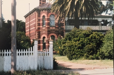
Photograph - 'Villa Alba', 44 Walmer Street, 1981
... villa alba -- 44 walmer street -- kew (vic.)...) villa alba -- 44 walmer street -- kew (vic.) mount royal ...Villa Alba, a two-storeyed residence with rendered masonry walls and a slate roof, stands opposite Studley Park, overlooking the Yarra River. It is believed to have been first built before 1863, but substantially remodelled and enlarged in about 1882-83 for William Greenlaw, the Manager of the Colonial Bank of Australasia. Although the house and its tower must always have been a landmark in the area and the architecture is unusual, almost Norman in style, it is the interior which is the most remarkable feature of Villa Alba. (Source: VHD)Small black and white photographic positive of Vila Alba, 44 Walmer Street, Kew in 1981 when the original 1880s house was surrounded by hospital wards. The latter had been built by the Royal Women's Hospital after it acquired the site in 1950. The site wa Slater transferred to the Mount Royal Hospital before being purchased and converted into a museum of interior design.Verso: "Villa Alba 1981"villa alba -- 44 walmer street -- kew (vic.), mount royal hospital, henry pride wing -
 Kew Historical Society Inc
Photograph - Street Beautification: Port Melbourne, 1980s
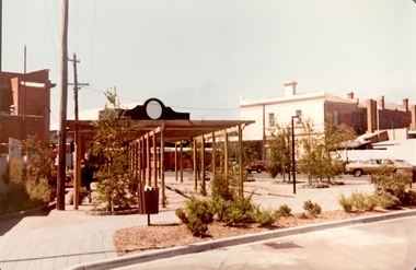
The City Engineer's Department within the former City of Kew, was responsible for public works, including street beautification. This photograph was held in the archives of the Department and was subsequently gifted to the Kew Historical Society. Like other examples originally held by the Department, photographs of road works, street beautification, engineering works were often sourced from other municipalities, or countries, to use as references for engineering works and design in Kew.Colour photographic positive (faded) of street beautification in Port Melbourne, used as a model by the Engineer's Department of the City of Kew for how civic spaces, including shopping centre precincts, could be improved. street beautification, city of kew -- engineers department, public works -- kew (vic.), port melbourne -
 Kew Historical Society Inc
Photograph - Street Beautification: Port Melbourne, 1980s
The City Engineer's Department within the former City of Kew, was responsible for public works, including street beautification. This photograph was held in the archives of the Department and was subsequently gifted to the Kew Historical Society. Like other examples originally held by the Department, photographs of road works, street beautification, engineering works were often sourced from other municipalities, or countries, to use as references for engineering works and design in Kew.Colour photographic positive (faded) of street beautification in Port Melbourne, used as a model by the Engineer's Department of the City of Kew for how civic spaces, including shopping centre precincts, could be improved. street beautification, city of kew -- engineers department, public works -- kew (vic.), port melbourne -
 Kew Historical Society Inc
Photograph - Yarra Valley Floods: Kew East, 1916
Flooding of the Yarra Valley, including that section of the Yarra bordering Kew and Kew East in the north and west of the municipality, was a regular occurrence. Extreme flood events of the Yarra River are recorded to have occurred in 1891, 1901, 1916, 1923 and 1934. The Municipality of Kew's response to these floods was to enact planning decisions restricting residential development in flood prone areas following the floods of 1916, 1921 and 1934. While floods continued after the development of the Upper Yarra Reservoir (construction 1948-57), the regularity and extent of these inundations diminished. During the nineteenth century, the land abutting the south side of the Yarra in Kew was devoted to dairy farming. In the twentieth century, before and after the construction of the Eastern Freeway, much of this low-lying area was used as golf courses and public parks.One of a collection of photographs of flooding in the Kew section of the Yarra Valley which are in important research resource for the location and extent of flooding in the first half of the twentieth century. Flooding of the Yarra Valley at East Kew in 1916. The view is taken from the intersection of Kilby Road with what is believed to be Birdwood Street, looking across the flood waters to Ivanhoe. The extensive flooded area shown in the photograph would have included the Kew Golf Club. Verso: "Floods along Kilby Road / near Birdwood St? & Kilby Road / 1917? / 87yarra river, yarra valley, floods -- kew, kilby road -- kew (vic.), kew golf club -
 Kew Historical Society Inc
Photograph - Yarra Valley Floods: Kew East, 1916
Flooding of the Yarra Valley, including that section of the Yarra bordering Kew and Kew East in the north and west of the municipality, was a regular occurrence. Extreme flood events of the Yarra River are recorded to have occurred in 1891, 1901, 1916, 1923 and 1934. The Municipality of Kew's response to these floods was to enact planning decisions restricting residential development in flood prone areas following the floods of 1916, 1921 and 1934. While floods continued after the development of the Upper Yarra Reservoir (construction 1948-57), the regularity and extent of these inundations diminished. During the nineteenth century, the land abutting the south side of the Yarra in Kew was devoted to dairy farming. In the twentieth century, before and after the construction of the Eastern Freeway, much of this low-lying area was used as golf courses and public parks.One of a collection of photographs of flooding in the Kew section of the Yarra Valley which are in important research resource for the location and extent of flooding in the first half of the twentieth century. Flooding of the Yarra Valley at East Kew in 1916. The view is taken from a street (maybe Birdwood Avenue) intersecting with Kilby Road looking northeast across the flood waters to Ivanhoe and Heidelberg. The extensive flooded area shown in the photograph would have included remnant dairy farms and the Kew Golf Club. Verso: "Floods / Yarra River / East Kew / Kilby Road / 1917? / 87"yarra river, yarra valley, floods -- kew, kilby road -- kew (vic.), kew golf club -
 Kew Historical Society Inc
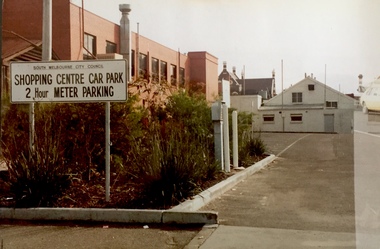
Photograph - Carpark: South Melbourne, 1980s
The City Engineer's Department within the former City of Kew, was responsible for public works, including street beautification. This photograph was held in the archives of the Department and was subsequently gifted to the Kew Historical Society. Like other examples originally held by the Department, photographs of road works, street beautification, engineering works were often sourced from other municipalities, or countries, to use as references for engineering works and design in Kew.Colour photographic positive (faded) of public parking in South Melbourne, perhaps used as a model by the Engineer's Department of the City of Kew for how civic spaces, including shopping centre precincts, could be improved. city of kew -- engineers department, public works -- kew (vic.), south melbourne, carparks, signs -
 Kew Historical Society Inc
Photograph - Civic event in Stradbroke Park, 1976
Stradbroke Park. Extent: Kilby Road to Harp Road at Burke Road. Historical Documentation: 1851 - Portion 91 purchased by Edward Glynn; 1888 - The Harp of Erin Estate (which included Section 91) offered for sale; 1896 - The area now known as Stradbroke Park was bisected by a creek that flowed from the Yarra via Hay's Paddock (q.v.) and extended through to Burke Road; 1943 - W.D. Birrell, Town Clerk of Kew, proposed that the creek be filled and a reserve created; 1954 - Entire area designated as 'open space' and named 'Stradbroke Park'. The line of the creek that ran through the Park created a further reserve on the north side of High Street, now known as 'Harrison Reserve'. Existing Condition: The park is largely of mown grass that has mature trees set into it It is possible that a number of these are remnant of the original vegetation, while there are also a number of exotic trees introduced, particularly at the northern end of the park. The southern end is dominated by playing fields. (Source: Sanderson, P 1988. Kew Conservation Study)Colour photographic positive (with colour degradation) of sporting teams at a civic event in Stradbroke Park in Kew East in May 1976. The event was officiated by the Mayor of Kew, Cr Alan Hutchinson. Sporting teams in uniform included: footballers, athletes, cricketers, hockey players. Stradbroke Park is situated on the western boundary of Kew at Burke and Harp Roads.stradbroke park, cr alan hutchinson, team sports -- kew (vic.) -
 Kew Historical Society Inc
Photograph - Civic event in Stradbroke Park, 1976
Stradbroke Park. Extent: Kilby Road to Harp Road at Burke Road. Historical Documentation: 1851 - Portion 91 purchased by Edward Glynn; 1888 - The Harp of Erin Estate (which included Section 91) offered for sale; 1896 - The area now known as Stradbroke Park was bisected by a creek that flowed from the Yarra via Hay's Paddock (q.v.) and extended through to Burke Road; 1943 - W.D. Birrell, Town Clerk of Kew, proposed that the creek be filled and a reserve created; 1954 - Entire area designated as 'open space' and named 'Stradbroke Park'. The line of the creek that ran through the Park created a further reserve on the north side of High Street, now known as 'Harrison Reserve'. Existing Condition: The park is largely of mown grass that has mature trees set into it It is possible that a number of these are remnant of the original vegetation, while there are also a number of exotic trees introduced, particularly at the northern end of the park. The southern end is dominated by playing fields. (Source: Sanderson, P 1988. Kew Conservation Study)Colour photographic positive (with colour degradation) of sporting teams at a civic event in Stradbroke Park in Kew East in May 1976. The event was officiated by the Mayor of Kew, Cr Alan Hutchinson. Stradbroke Park is situated on the western boundary of Kew and bordered by Burke and Harp Roads.stradbroke park, cr alan hutchinson, team sports -- kew (vic.) -
 Kew Historical Society Inc
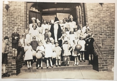
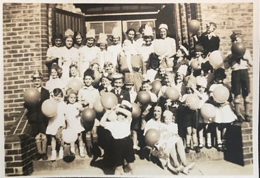
Photograph - St Hilary's Church Christmas Party, c.1932
St Hilary's Anglican Church in Kew was established in 1888 on land granted to the congregation by the Dumaresq family. The brick building shown here replaced an earlier wooden structure.Small black and white photographic positive, one of four, of a Christmas party for children at St Hilary's Church, 12 John Street, Kew. The children, surrounding an adult Santa Claus, are dressed in festive costumes and a number carry balloons. The foundation plaque is on the wall to the children's left. The photo was tentatively dated to 1932 by the donor. Inscribed verso: "St Hilary's Christmas Party ?1932"churches -- kew (vic.), st hilary's church -- kew, anglican churches -- melbourne (vic.) -
 Kew Historical Society Inc
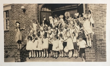
Photograph - St Hilary's Church Christmas Party, c.1932
St Hilary's Anglican Church in Kew was established in 1888 on land granted to the congregation by the Dumaresq family. The brick building shown here replaced an earlier wooden structure.Small black and white photographic positive, one of four, of a Christmas party for children at St Hilary's Church, 12 John Street, Kew. The children, surrounding an adult Santa Claus, are dressed in festive costumes and a number carry balloons. The photo was tentatively dated to 1932 by the donor. Inscribed verso: "St Hilary's Christmas Party ?1932"churches -- kew (vic.), st hilary's church -- kew, anglican churches -- melbourne (vic.) -
 Kew Historical Society Inc
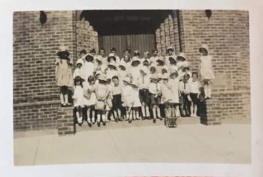
Photograph - St Hilary's Church Christmas Party, c.1932
St Hilary's Anglican Church in Kew was established in 1888 on land granted to the congregation by the Dumaresq family. The brick building shown here replaced an earlier wooden structure.Small black and white photographic positive, one of four, of a Christmas party for children at St Hilary's Church, 12 John Street, Kew. The children are formally dressed with most wearing hats. The photo was tentatively dated to 1932 by the donor. Inscribed verso: "1932 St Hilary's Christmas Party"churches -- kew (vic.), st hilary's church -- kew, anglican churches -- melbourne (vic.) -
 Kew Historical Society Inc
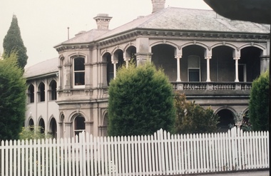
Photograph - Preshil (formerly 'Blackhall'), 26 Sackville Street, 1988
... blackhall -- sackville street -- kew (vic.)... -- sackville street -- kew (vic.) catherine booth girls’ home salvation ...This grand Italianate mansion at 26 Sackville Street was built in 1890 as a private home. In May 1915, ‘Blackhall’ was purchased for £1800 by the Salvation Army and renamed the ‘Catherine Booth Girls’ Home’. The Home provided accommodation from 1915 to 1976 for about 90 to 100 girls between the ages of 4 and 16. An original plaque can still be seen at the front entrance. ‘Preshil, the Margaret Lyttle Memorial School’ purchased Blackhall for its Senior School in 1978. The photograph dates from 1945.Colour photographic positive of one of the houses in Sackville Street, now Preshil but formerly 'Blackhall'. Also at one stage the Salvation Army Catherine Booth Girls’ Home. Built in 1890, Blackhall is of significance as a typical and intact late Victorian mansion and as such is one of the key Victorian Buildings to have been built in Kew. It is integral to the significance of the concentration of Victorian mansions along Sackville Street.blackhall -- sackville street -- kew (vic.), catherine booth girls’ home, salvation army -- kew (vic.) -
 Kew Historical Society Inc
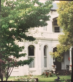
Photograph - 'Berrington', 29 Sackville Street, Kew, 1988
... berrington -- sackville street -- kew (vic.)... Conservation Study, 1988) berrington -- sackville street -- kew (vic ...'Berrington' in Sackville Street was built in 1888 for Job Smith, builder, who was the first owner of this substantial two-storey house. The property was given an initial N.A. V. of £125 3 and it is possible that Smith was the contractor for his house.By the turn of the century 'Berrington' was identified as having thirteen rooms and an N.A.V. of £13 while the house remained in the hands of the Smith family until the late 1930s. The new owner at that stage was a Mrs Pederson who convened the house into three flats 6 while in 1951 it was further subdivided to become seven units. (Kew Conservation Study, 1988)Colour photographic positive of one of 'Berrington'. The building is a large two storeyed house typical of the late Victorian period. It remains substantially intact with a cast iron verandah dominating the front and side facades, that has the added distinction of a fine cast iron frieze that at ground floor level has two tiers. Behind the verandah, the facade is asymmetrical. There is a central six panelled door with a fine semicircular fanlight, and segmentally arched windows to the ground floor and on one side of the door there is a polygonal bay window that extends up the two floors. The eaves and chimneys are decorated with Italianate brackets. (Kew Conservation Study, 1988)berrington -- sackville street -- kew (vic.), job smith -
 Kew Historical Society Inc
Photograph - 'La Verna' (formerly 'Heathfield'), 39 Sackville Street, 1988
... heathfield -- sackville street --- kew (vic)... street --- kew (vic) la verna -- sackville street -- kew (vic ...Documentary evidence records that in 1888 Henry Eeles, stationer, was the first owner and occupier of this two-storey mansion. At that date the building was given an N.A.V.of £275 and Eeles was recorded as the owner of the house until at least 1910, when the thirteen-roomed mansion attracted an N.A.V. of £190. The house is quite typical of time, and it bears a remarkable resemblance to 3 Molesworth Street, the architect of which has not been established. (Kew Conservation Study, 1988)Colour photographic positive of one of 'La Verna' (formerly 'Heathfield'). The house is two storeyed and clad in render. It is ltaIianate in styling and is dominated by a two storeyed loggia that spans two facades. At ground floor level it has rounded arches supponed on cast iron colonettes, and above, has colonettes that support stilted segmental arches. (Kew Conservation Study, 1988)heathfield -- sackville street --- kew (vic), la verna -- sackville street -- kew (vic.) -
 Kew Historical Society Inc
Photograph - Preshil (formerly 'Kalimna'), 12 Sackville Street, 1988
... kalimna -- sackville street -- kew (vic.)... at least 1910, kalimna -- sackville street -- kew (vic.) preshil ...Documentary evidence records that in 1890 William H. Jarman, accountant, was the first owner and occupier of 'Kalimna', a substantial rwo-storey residence; it having an initial N.A.V. of £1503. In the following year the N.A.V. for the eleven-roomed property had increased to £2504 indicating that the building had been completed. Jarman is recorded as owning and occupying 'Kalimna' until at least 1910,Colour photographic positive of one of 'Kalimna'. The house is typical of the late Victorian period with polychromatic brick walls, a two storeyed, cast iron decorated verandah that spans two facades, and a polygonal bay window extending to the front. The eaves and chimneys are decorated with Italianate brackets executed in render. The slate roof remains intact, including its cast iron finials. (Kew Conservation Study, 1988)kalimna -- sackville street -- kew (vic.), preshil -
 Kew Historical Society Inc
Photograph - 'Prague House' (formerly 'Dunboe'), 52 Sackville Street, 1988
... prague house -- sackville street -- kew (vic.)... Conservation Study, 1988) prague house -- sackville street -- kew (vic ...Documentary evidence records that the first occupier of this substantial two-storey residence was Harry Karlbaum, a sharebroker and although the owner's name is not listed in the Rate Books for this first year, it appears in 1893 as Robert Crawford Anderson, a merchant, The property was given an initial N.A.V. of £150 in 1892 while by 1900 it was listed as having eleven rooms. (Kew Conservation Study, 1988)Colour photographic positive of one of 'Prague House'. The house is clad in render and is typical of the late Victorian period with an asymmetrical composition that has a loggia of stilted segmental arches at both levels that turns the corner of the house, and a polygonal bay window on one side of the front facade. The application of colonettes across the facade, the square piers to the loggia. and the lift in the eave to form a gable unit are less typical. (Kew Conservation Study, 1988)prague house -- sackville street -- kew (vic.), dunboe -- sackville street -- kew (vic.)