Showing 11483 items matching "maps "
-
 Canterbury History Group
Map - Maling Road Built form Map, Ciy of Boroondara, 2015
... Maps ...Map copied from the 'Urban Planning Special Committee Agenda' Design and Development Overlay- Schedule 23 showing heritage property on Maling Road. Produced by The City of Boroondaracanterbury, maling road, heritage buildings, city of boroondara, urban planning special committee agenda, maps -
 Bendigo Military Museum
Map - TRENCH MAP, FRANCE WW1, 1918
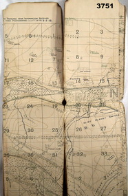
Areas covered on this map “Corbie, Villers Brettoneaux, Hangard Wood, Aubigney, River Somme”. Item re William Alexander No 502 AIF. Refer Cat No 3746.3 for his service details.Trench map, France, Edition 2A, sheet 62D S.W, scale 1:20,000, British trenches in blue, trenches corrected to 9.5.1918.map, france, trench -
![Map, [Plan for road to give J. Allan access to permanent water at Coimadai] circa 1870s](/media/collectors/5e461d8021ea67224c82f2a1/items/67735190d671e67dd573a84c/item-media/6773533dd671e67dd573cd90/item-fit-380x285.jpg) Bacchus Marsh & District Historical Society
Bacchus Marsh & District Historical SocietyMap, [Plan for road to give J. Allan access to permanent water at Coimadai] circa 1870s
The date of this map or plan is uncertain but it appears to be from the early to mid 1870s. One of the landholders identified on the plan, James Allan of Coimadai died suddenly on the 9th July, 1874 (see Bacchus Marsh Express, 11 July, 1874, page. 3). There are mentions of an Allans Road at Coimadai in the Bacchus Marsh Express between 1887 and 1942.Single page map showing an excision of land belonging to Charles Ross which was selected to construct a road to give another landholder, J. Allan access to permanent water. Scale 1 chain to 1 inch. Part of a set of maps which are pasted into a bound volume containing 76 maps or plans in total. High resolution digital image stored on BMDHS computer network. Plan showing Excisions from Ross's selection and 1 chain road thro' the said selection in Coimadai to give J. Allan access to permanent water. Alistair ?? Shire Eng? 6?/5/7?coimadai victoria maps, coimadai roads and streets -
 Beechworth Honey Archive
Hand-Drawn Map Centred on Worouly by Frank Lebbell Frost December 1916
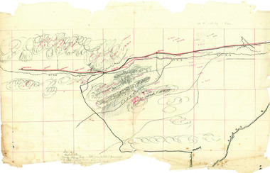
This is one of the maps drawn by Frank L. Frost while he was beekeeping in North-East Victoria. This particular map may be reference in the "Wooden" Diary on page 10.Hand-drawn map centred on Whorouly and showing other towns, including Oxley, Byrne, Edi and Whitfield. Details the local flowering eucalypts. Scale is each red square equals three miles. Drawn with black pen and grey lead on paper. Grid and other features are marked in red.hand drawn, hand-drawn, map, oxley, byrne, whitfield, edi, frost, beekeeping, beechworth honey -
 Bendigo Historical Society Inc.
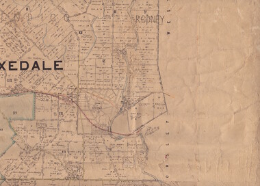
Map - Parish of Strathfieldsaye
Map owned by Henry Thomas (Jack) Qualtrough who worked for the Victorian Forestry Commission. Shire of Strathfieldsaye County of Bendigo canvas backed map. L5169. Includes Axedale, Kimbolton, Eppalock and Sedgewick. Photographed/Lithographed for the Department of Lands and Survey Melbourne by T E McGauran 24.3.07. Price 1/-.map, axedale, kimbolton, sedgewick, eppalock -
 Flagstaff Hill Maritime Museum and Village
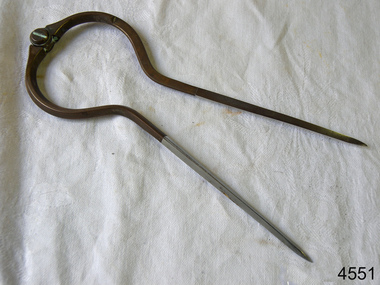
Dividers, Early 20th Century
Dividers are used by navigators to measure the distance between two points on a map or chart. Each point of the divider is places on a map point, then the distance between the points of the divider is measured against the scale of the chart or map. This helps determine the ship's path of travel, the distance travelled and the current location.Not very significant as not associated with any historical event or person, same pattern of dividers is available today from many retail outlets. Also item was probably made around 1940s to 1950sDividers; brass navigator's dividers with fine, stainless steel points. Made in Britain by W & H C (inscription). This navigational tool is used by a ship's navigator to mark the ship's position. Each end point of the divider is placed on a position on a chart or map, then the length between the points of the divider is measured on the chart's scale.Inscribed "British Made" and "W & H C". flagstaff hill, warrnambool, shipwrecked-coast, flagstaff-hill, flagstaff-hill-maritime-museum, maritime-museum, shipwreck-coast, flagstaff-hill-maritime-village, navigational dividers, navigational tool, dividers made by w & hc, w & hc britain -
![Book - Map, Land Conservation Council, Melbourne Study Area Report, [December 1973]](/media/collectors/4f729f7b97f83e03086018a5/items/6469bc241d76dd4b008a829f/item-media/646b0013d841f8920fa4323c/item-fit-380x285.jpg) Eltham District Historical Society Inc
Eltham District Historical Society IncBook - Map, Land Conservation Council, Melbourne Study Area Report, [December 1973]
... maps ...The Melbourne Study Report is a series of volumes describing the physical nature of the land and its environment, examines the likely forms of land use, and assesses the hazards associated with these uses. This is Volume 2 (coloured maps). The first page featues a black and white map described as "Shire of Diamond Valley" with public land marked in yellow. Followed by eight large fold out maps. Melbourne Study Area Public land and descriptive blocks, Population description, Geology, Physiography, topography and rainfall, vegetation and water supply. The Land Conservation Act 1970 established the Land Conservation Council whose functions is to "carry out investigations and make recommendations to the Minister with respect to the use of public land in order to provide for the balanced use of land in Victoria. This report sets out to describe and assess the natural resources of the public lands in the Melbourne area and provides a factual basis on which members of the community may base submissions to the [Land Conservation] Council of Victoria.A collection of eight large fold out coloured maps published in a bound book formnon-fictionThe Melbourne Study Report is a series of volumes describing the physical nature of the land and its environment, examines the likely forms of land use, and assesses the hazards associated with these uses. This is Volume 2 (coloured maps). The first page featues a black and white map described as "Shire of Diamond Valley" with public land marked in yellow. Followed by eight large fold out maps. Melbourne Study Area Public land and descriptive blocks, Population description, Geology, Physiography, topography and rainfall, vegetation and water supply. The Land Conservation Act 1970 established the Land Conservation Council whose functions is to "carry out investigations and make recommendations to the Minister with respect to the use of public land in order to provide for the balanced use of land in Victoria. This report sets out to describe and assess the natural resources of the public lands in the Melbourne area and provides a factual basis on which members of the community may base submissions to the [Land Conservation] Council of Victoria. maps, shire of diamond valley, population, geology, topography, rainfall, vegetation, water supply, land use, public lands -
 Bacchus Marsh & District Historical Society
Map, Bacchus Marsh Tuesday 23rd Oct. 1888, Lodge & Dunn's Paddocks 1888. Business and Mansion Sites
This map was created as a plan for an auction of land close to the Bacchus Marsh Railway Station. The auction took place on 23 October 1888. 102 allotments of land from an area known as Lodge and Dunn's paddocks was offered for sale. The auction was conducted by auctioneers based in Melbourne and was advertised in Melbourne newspapers as well as in the Bacchus Marsh Express newspaper. The auction plan contains a range of details including the selling agents, Munro and Baillieu; W.P. Lockhart; and John Turner, all of Melbourne, deposit terms for purchases, price of railway passes for a return trip from Melbourne to Bacchus Marsh of 1 shilling, and a description of the land as having 'magnificent views and perfect drainage'. A single page paper map showing allotments of land for sale along the Parwan Road in Maddingley. The map is pasted into a bound volume containing 76 maps or plans in total. High resolution digital image stored on BMDHS computer network. At bottom on left side: 'Harston & Co. Lith, Melb.'land sales bacchus marsh, land sales maddingley, bacchus marsh victoria maps, maddingley victoria maps -
Kew Historical Society Inc
Book, Joseph Johnson, Birdies and Billabongs: a history of the Kew Golf Club, 1894-1994, 1994
x, 206 p. : ill. (some col.), maps, ports. ; 22 x 28 cm. non-fictionkew golf club - history, golf courses - victoria - melbourne - history, golf - victoria - melbourne - history -
Kew Historical Society Inc
Book, Geoff Hocking, Castlemaine : from camp to city 1835-1900, a pictorial history of Forest Creek & the Mount Alexander goldfields, 1994
230 p. : ill. (some col.), facsims, maps, ports. ; 22 x 25 cm.non-fictiongold mines and mining -- victoria -- castlemaine -- history, castlemaine (vic.) -- history -
 Kew Historical Society Inc
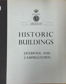
Book, Cumberland County Council, Historic Buildings: Liverpool and Campbelltown, 1963
[Liverpool, N.S.W.] : Cumberland County Council, 1963 54 p. : ill., maps ; 26 cm. non-fictionhistoric buildings -- new south wales -- liverpool., historic buildings -- new south wales -- campbelltown. -
 Kew Historical Society Inc
Map, Real Estate Map of Bulleen, Templestowe, Lower Templestowe, Doncaster, North Balwyn
A large undated printed map of Bulleen, Templestowe, Lower Templestowe, Doncaster, North Balwyn showing major and minor roads, waterways and proposed facilities in this area of Melbourne.A useful if undated real estate map that allows viewers to compare current and historic aspects of these areasMap of Bulleen, Templestowe, Lower Templestowe, Doncaster, North Balwyn used by JB Thomson & Co, Real Estate Agents, to identify and record land sales on these. There are some markings on the plan indicating the location and price of lots.subdivision plans, bulleen, templestowe, lower templestowe, doncaster, north balwyn -
 Melbourne Tram Museum
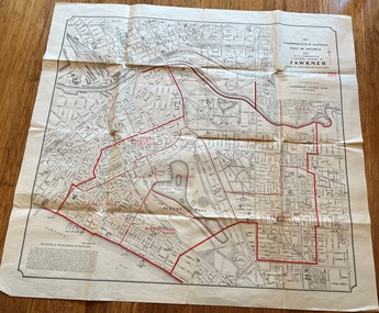
Map, Department of Lands and Survey Melbourne, Commonwealth Electoral Division of Fawkner, 1-10-1912
... maps ...Shows a detailed street plan of South Melbourne, Albert Park, Prahran, South Yarra and parts of Melbourne in 1912. Used to mark the electoral boundaries of the Commonwealth Electoral Division of Fawkner. Shows all the then cable tram lines, rail lines and the electric line of the PMTT along with docks, gardens and significant buildings.Gives details of the Fawkner Electoral district in 1912.Folded sheet - Map - Commonwealth Electoral Division of Fawkner - two colours showing the subdivisions and polling placesmelbourne, fawkner, tram lines, cable trams, maps, electoral maps, south melbourne, albert park, prahran -
Whitehorse Historical Society Inc.
Map, Shire of Nunawading (part)
... Maps ...Photocopy of map of part of Shire of Nunawading. area along Whitehorse Road from Box hill to Mitcham.Photocopy of map of part of Shire of Nunawading. area along Whitehorse Road from Box hill to Mitcham. Mitcham Station marked as Emery's Hill.Photocopy of map of part of Shire of Nunawading. area along Whitehorse Road from Box hill to Mitcham.maps, shire of nunawading, box hill, blackburn, nunawading, mitcham, emery's hill -
 Melbourne Tram Museum
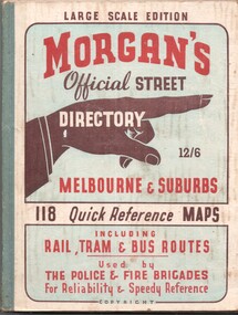
Book, The Met, "Morgan's Official Street Directory - Melbourne and Suburbs", c1951
... Maps ...Book - 5 sections, sewn with green cloth spine binding, card covers, 188 pages, 118 maps, titled "Morgans Official Street Directory - Melbourne and Suburbs" Has many advertisements around edges of the maps. Shows the Latrobe St line (opened 1/1951), but not the Bourke St tram line. Price 12/6. Published by Val Morgan and Sons of 64 Elizabeth St Melbourne. A web search for similar directories - Museum of Victoria - https://collections.museumsvictoria.com.au/items/1217271 gives background to the directory.trams, tramways, maps, melbourne, street directory -
 Ringwood and District Historical Society
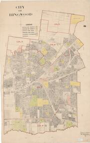
Map, City of Ringwood - Rateable Properties Layout - c.1966. Overlay showing Reserves, Open Space, Playgrounds, and Schools
A0-size (approx) map of named streets, lot-numbered properties and locality features within City of Ringwood boundary. Colour-coded legend identifying Existing Rec Reserves, Proposed Rec Reserves, Existing Open Space, Children's Playgrounds, and Schools.Scale: 8 chains to 1 inch. Map picked up in Engineer's office at old town hall prior to demolition 1971. -
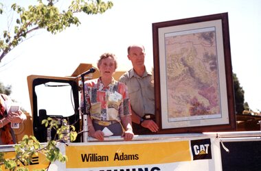 Stawell Historical Society Inc
Photograph, Gold Fields Map Presentation to the Stawell Historical Society, 2001
Gold Fields Map Presentation to SHS.Three (3) Colour Photographs 1: SHS President Betty Jackson presented with goldfields map. by goldfoelds manager, Richard Carlton. 2: Mayor Karen Douglas, with Betty Jackson and Richard Carlton 3: Mayor Karen Douglas presenting colouring competition to School childrenstawell -
 Greensborough Historical Society
Map, Melbourne and Metropolitan Board of Works. Survey Division, MMBW, Yarra 2500 / 16.22. Research, 1979_05
Melbourne and Metropolitan Board of Works. Yarra 2500 [base map] 16-22. Research. Parish of Nillumbik 3310. Municipalities of Diamond Valley 257 and Eltham 238. Prominent streets include: Orme Road and Allendale Road. MMBW Map in 1:2500 [scale] series. Cream parchment with green tape reinforcing on edges and punched holes on left edge.mmbw, melbourne and metropolitan board of works, shire of diamond valley, diamond creek - maps -
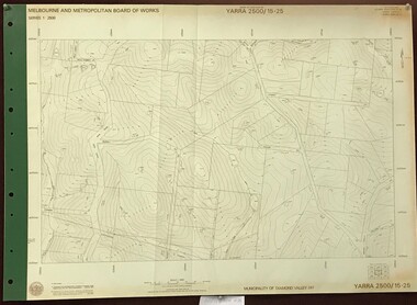 Greensborough Historical Society
Map, Melbourne and Metropolitan Board of Works. Survey Division, MMBW, Yarra 2500 / 15.25. Yarrambat, Black Gully Road, 1978_07
Melbourne and Metropolitan Board of Works. Yarra 2500 [base map] 15.25. Yarrambat, Black Gully Road. Municipality of Diamond Valley 257. Prominent streets include: Black Gully Road, Ironbark Road and Murray Road. MMBW Map in 1:2500 [scale] series. Cream parchment with green tape reinforcing on edges and punched holes on left edge.mmbw, melbourne and metropolitan board of works, shire of diamond valley, yarrambat - maps -
Whitehorse Historical Society Inc.
Document, Street names, 1989
Artic;le by Gwenda Trethewy, member of Nunawading Historical SocietyArtic;le by Gwenda Trethewy, member of Nunawading Historical Society, on the history of the Mitcham street names, Endeavour, Flinders, Moresby and Beaufort, Oct - Dec 1989 and map of the area and an extract of the article.Artic;le by Gwenda Trethewy, member of Nunawading Historical Societystreet names, trethewey, gwenda, turner, (commander), nunawading historical society, endeavour street, mitcham, flinders street, mitcham, moresby street, mitcham, beaufort street, mitcham -
 Kiewa Valley Historical Society
Parish Maps - Kiewa Valley
The Parish Maps show how the Counties were divided into allotments for buyers. On one the original owners are named and the sizes of their properties given. The reference numbers enable individuals research the history of the property. The other is on a smaller scale giving only the allotment numbers. The map with the names gives information on the early settlers of the Kiewa Valley. They show how the Kiewa Valley was divided up into allotments for town dwellers and farmers and enables further research.Two copies of Parish Maps of the towns in the Kiewa Valley. One gives the original owners and the other the reference numbers of the allotments.kiewa valley. parish maps. land owners -
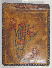 Mission to Seafarers Victoria
Album - Photographic album, Allan Charles Quinn
This photo album documents the voyage of Allan Quinn while he was in the merchant navy. The album and photos give a view of Quinn's trips around the world and the many places he visited. Leather-bound photo album. Cover is embossed with a colour map of South America.The cover contains the map of South America with a picture of a man with a pipe in his mouth in the top left-hand corner and a picture of a sailing ship in the bottom right. The inside front cover lists in handwritten columns: ports of call during 1947-48. There are three loose photos inside the front cover. album, photos, allan quinn, tourism, seafarers, sailors, seamen, ships -
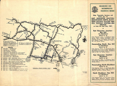 Melbourne Tram Museum
Ephemera - Timetable, Melbourne & Metropolitan Tramways Board (MMTB), East Doncaster Junction, Nunawading North, Jul, 1961
Timetables for specific routes, day of week giving information on tram times at specific time points, route map, sections and fares and organisation address - 616 Little Collins St. Melbourne. 2nd July 1961 1 - East Doncaster Junction, Nunawading North, Blackburn Railway Station, Box Hill Railway Station- Mitcham - Ringwood. 2 - Doncaster Junctioin - Melbourne - route 81 with many supplementary routes - July 1961 3 - Bulleen - City - Garden City routes 15 and 16 - July 1961Demonstrates and early MMTB timetable for bus routes which included extensive details of services.Set of 3 MMTB Bus timetable, folded sheets with maps. Bus routes underlined in blue inktrams, tramways, timetables, tickets, bus services, fares, mmtb, doncaster, ringwood, mitcham, bulleen, garden city, route 15, route 16, route 81 -
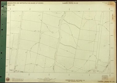 Greensborough Historical Society
Map, Melbourne and Metropolitan Board of Works. Survey Division, MMBW, Yarra 2500 / 15.28. Yarrambat, 1977_10
Melbourne and Metropolitan Board of Works. Yarra 2500 [base map] 15-28. Yarrambat. Municipalities of Diamond Valley 257 and Whittlesea 239. Prominent streets include: Edward Henty Avenue, Charles Sturt Drive and Creighton Way. MMBW Map in 1:2500 [scale] series. Cream parchment with green tape reinforcing on edges and punched holes on left edge.mmbw, melbourne and metropolitan board of works, shire of diamond valley, yarrambat - maps -
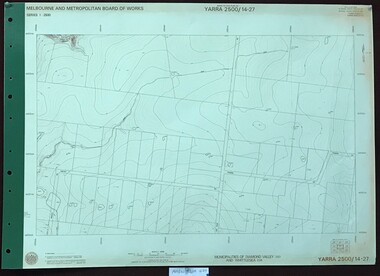 Greensborough Historical Society
Map, Melbourne and Metropolitan Board of Works. Survey Division, MMBW, Yarra 2500 / 14.27. Yarrambat, Youngs Road, 1977_09
Melbourne and Metropolitan Board of Works. Yarra 2500 [base map] 14.27. Yarrambat, Youngs Road. Municipalities of Diamond Valley 257 and Whittlesea 239. Prominent streets include: Youngs Road, Ashley Road and Yan Yean Road. MMBW Map in 1:2500 [scale] series. Cream parchment with green tape reinforcing on edges and punched holes on left edge.mmbw, melbourne and metropolitan board of works, shire of diamond valley, whttlesea, yarrambat - maps -
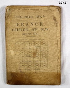 Bendigo Military Museum
Map - TRENCH MAP, FRANCE WW1, 1917
Main Australian areas on this map include “Grevillers, Bapaume and Fremicourt” Item re W.A Alexander No 502 AIF. Refer Cat No 3746.3 for his service details.Trench map, France, sheet No 57N.W. Edition6A, scale 1:20,000, trenches corrected to 7.2.1917, German trenches in red, on rear glossary of terms French to English.map, trench, france -
Whitehorse Historical Society Inc.
Map, Nunawading, 1972
... Maps ...Variation of original 1864 map with a number of additions and bold marking of an area including Forest Hill, Vermont and Vermont South as 'Proclaimed survey area No 21 May 1972 2826. Marked as P M Noting Melb SeriesVariation of original 1864 map with a number of additions and bold marking of an area including Forest Hill, Vermont and Vermont South as 'Proclaimed survey area No 21 May 1972 2826. Marked as P M Noting Melb Series.Variation of original 1864 map with a number of additions and bold marking of an area including Forest Hill, Vermont and Vermont South as 'Proclaimed survey area No 21 May 1972 2826. Marked as P M Noting Melb Seriesmaps, shire of blackburn and mitcham, forest hill, vermont, vermont south -
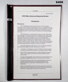 Bendigo Military Museum
Administrative record - DIGO Map Library and Repromat Review 2004, Geospatial Analysis Centre, Bendigo, 25 Oct 2004
Prior to the digital revolution the only medium by which cartographic information could be reproduced and distributed on mass was via printed media. The final negatives (repromat) used to produce the printed products were the culmination of a complex cartographic process and were therefore carefully preserved and stored. Preservation of the so-called final negatives enabled subsequent reprinting with minimal cartographic intervention. Since the arrival of the Land Headquarters Cartographic Company at Fortuna in 1942 the repromat for all products produced by the Australian Survey Corps were carefully stored. With the disbandment of the Army Survey Regiment in 1996 the Defence Imagery and Geospatial Organisation (DIGO) inherited that repromat archive. It was immanent that the support for film based printing was ending so on 25 October 2004 a review was required to determine the way ahead for the repromat and paper maps stored in the DIGO Map Libraries. Most of these maps were produced by the Royal Australian Survey Corps. This report is the result of that review. The report recommends the disposal of the repromat and the retention of single map copies. A4 plastic covered report, plastic clip bound, front page clear and rear page red. 9 x page document about the future of repromat and map printing.royal australian survey corps, rasvy, fortuna, army survey regiment, army svy regt, asr -
![A History of Victoria / [by] Geoffrey Blainey](/media/collectors/550653872162f11fb04854aa/items/5ed04756dcf9cd08346b8e7a/item-media/5ed0486bdcf9cd08346b908e/item-fit-380x285.jpg) Kew Historical Society Inc
Kew Historical Society IncBook - Brown Gouge clothes brush, Cambridge University Press, A History of Victoria, 2006
Originally published as 'Our side of the country' in 1984 and in 1992. "For this third edition there has been extensive rewriting"--Preface. Includes bibliographical references and index.Port Melbourne, Vic. : Cambridge University Press, 2006 viii, 304 p. : maps ; 22 cm. non-fictionOriginally published as 'Our side of the country' in 1984 and in 1992. "For this third edition there has been extensive rewriting"--Preface. Includes bibliographical references and index.victoria -- history., victoria -- social life and customs. -
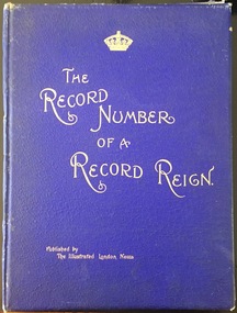 Kew Historical Society Inc
Book, Her Majesty's Glorious Jubilee 1897: the record number of a record reign, 1897
Part of rare book collection.London : Proprietors of the Illustrated London News, [1897] 54 p. : ill., maps, ports. ; 41 cm. non-fictionPart of rare book collection.victoria queen of great britain 1819-1901, great britain -- history -- victoria 1837-1901.