Showing 3828 items
matching survey
-
 Glenelg Shire Council Cultural Collection
Photograph - Photograph - Aerial Photo railway line between Heywood and Rennick, 03/05/1952
Victorian Railways aerial survey record print of the railway line between Heywood and Rennick (S.A. border) Black and white, white vertical strip on imageBack: 'Heywood - Rennick 21359 - 19630 258m 30c ' - all black ink. Purple VR aerial survey stamp. '3 May 1952' - black stamp -
Glenelg Shire Council Cultural Collection
Photograph - Photograph - Aerial Photo railway line between Heywood and Rennick, 03/05/1952
Victorian Railways aerial survey record print of the railway line between Heywood and Rennick (S.A. border) Black and white, white vertical strip on imageBack: 'Heywood - Rennick 21392 - 19663 261m 26c ' - all black ink. Purple VR aerial survey stamp. '3 May 1952' - black stamp -
Glenelg Shire Council Cultural Collection
Photograph - Photograph - Aerial Photo railway line between Heywood and Rennick, 03/05/1952
Victorian Railways aerial survey record print of the railway line between Heywood and Rennick (S.A. border) Black and white, white vertical strip on imageBack: 'Heywood - Rennick 21528 - 19791 273m 72c ' - all black ink. Purple VR aerial survey stamp. '3 May 1952' - black stamp -
Glenelg Shire Council Cultural Collection
Photograph - Photograph - Aerial Photo railway line between Heywood and Rennick, 03/05/1952
Victorian Railways aerial survey record print of the railway line between Heywood and Rennick (S.A. border) Black and white, white vertical strip on imageBack: 'Heywood - Rennick 21393 - 19664 261m 34c ' - all black ink. Purple VR aerial survey stamp. '3 May 1952' - black stamp -
Glenelg Shire Council Cultural Collection
Photograph - Photograph - Aerial Photo railway line between Heywood and Rennick, 03/05/1952
Victorian Railways aerial survey record print of the railway line between Heywood and Rennick (S.A. border) Black and white, white vertical strip on imageBack: 'Heywood - Rennick 21387 - 19658 260m 68c' - all black ink. Purple VR aerial survey stamp. '3 May 1952' - black stamp -
Glenelg Shire Council Cultural Collection
Photograph - Photograph - Aerial Photo railway line between Heywood and Rennick, 03/05/1952
Victorian Railways aerial survey record print of the railway line between Heywood and Rennick (S.A. border) Black and white, white vertical strip on imageBack: 'Heywood - Rennick 214576 - 19839 279m 32c ' - all black ink. Purple VR aerial survey stamp. '3 May 1952' - black stamp -
Glenelg Shire Council Cultural Collection
Photograph - Aerial Survey Railway Record Print – 1952, 03/05/1952
Victorian Railways aerial survey record print of the railway line between Heywood and Rennick (S.A. border) Black and white, white vertical strip on image.Back: 'Heywood - Rennick 21531 - 19794 274m 18c ' - all black ink. Purple VR aerial survey stamp. '3 May 1952' - black stamp -
Glenelg Shire Council Cultural Collection
Photograph - Photograph - aerial view of railway line between Heywood and Rennick, 03/05/1952
From a series of photographs taken for Victorian Railways in 1952.Back: 'Heywood - Rennick 21394 - 19665 261m 42c ' - all black ink. Purple VR aerial survey stamp. '3 May 1952' - black stampvictorian railways, heywood, rennick, aerial photography -
 Ballan Shire Historical Society
Map - Map. Ballark, Ballark. County of Grant, 31/08/1915
A map of the Ballark area within the County of Grant showing roads, waterways, property boundaries and property owners in 1915.Significant to people researching land usage and ownership. Also those researching families in the area at that time.A map of Ballark in the County of Grant. Black printing on buff coloured paper. Extra notations by hand and various coloured highlighting of certain features. Details roads, rivers, property boundaries and names of property owners and districts. The map is easily readable although there is some physical damage to the borders and some sellotape residue. Shows a scale in Chains and the number L.6030Various numbers and directional arrows added to map.bungal, borhoneyghurk, bungeeltap, ballark, beremboke, moreep, meredith, morrisons, moorarbool river -
 Ballan Shire Historical Society
Map - Map. Kerrit Bareet, Kerrit Bareet. County of Grant, 08/1944
A map of the Kerrit Bareet area within the County of Grant showing properties and names of owners in 1944.Significant to people researching land usage and ownership. Also those researching families in the area at that time.A map of Kerrit Bareet in the County of Grant. Black printing on buff coloured paper. Details roads, rivers, railways, property boundaries and names of property owners and towns and villages. The map is easily readable although there is some physical damage and that and the borders have been reinforced with sellotape. Shows a Scale in Chains and Price 2/.gordon, bungal, kerrit bareet, lal lal, moorarbool river, warrenheip, bungaree, wallace, moorarbool west -
 Ballan Shire Historical Society
Map - Map. Korweinguboora, Korweinguboora. Counties of Talbot and Grant
A map of the Korweinguboora area showing roads, forests, railway lines and properties with the owners names.The inclusion of the names of landowners is of significance and value to historians.A map of the Korweinguboora area showing land subdivisions and names of owners and other physical features. There is a scale in chains. No date is certain but it could be 1902. The map has been repaired with sellotape.There are various pencil annotations but the are difficult to read.talbot, moorarbool west, wombat, bullarto, korweinguboora, moorarbool east, dean, wombat state forest, barkstead -
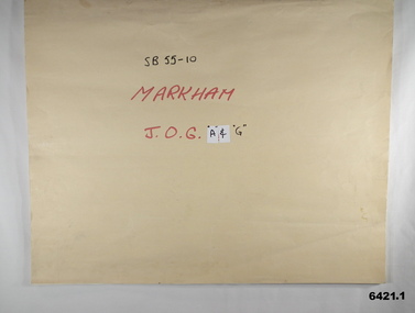 Bendigo Military Museum
Map - SB55-10 Markham Joint Operations Graphics Air and Ground print separations, Dec 1981
This set of map prints was assembled as a training aid. The collection is a complete set of individual color prints of each colour used on the final printed maps for each map Joint Operations Graphic (JOG) JOG Ground and JOG Air versions. This map series was produced in two versions to help coordinate military Ground Operations and Air Operations. The ground users required that heights and measurements were in Metres, whilst air users required height information in Feet for altimeters. The Air Version also contained more Aeronautical information including safe flying height information called Maximum Elevation Figures (MEF). Later printing of JOG incorporated printing in just four colours Cyan, Magenta, Yellow and Black (CMYK). Item 6421.1 is an example of a JOG Ground and item 6421.2 is an example of its matching JOG Air version.1:250,000 SB55-10 Markham JOG A and G colour separations bound together in a manilla card covered folder bound with a timber edge. royal australian survey corps, rasvy, fortuna, army survey regiment, army svy regt, asr -
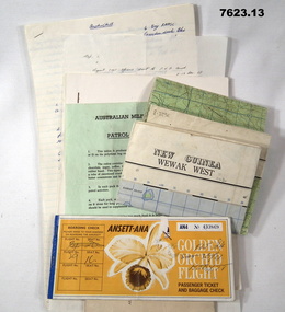 Bendigo Military Museum
Document - PNG PAPERS, HERDMAN, 1964- 1969
Collection of documents related to K.J. Herdman's visit to PNG as part of CMF Officer's visit, 2nd Dec to 13th Dec 1968. Part of the "Kevin John Herdman" No. 397661 Collection. See Catalogue No. 5942P for details of his service. 2. Notes related to Herdman's visit to PNG. List of personnel on visit. 4. Patrol ration pack details. 5. PNG Training Depot Hand Book, 6. Report - CMF Officer's visit to PNG. 2-13 Dec 1968. 8. Extended report by K.J. Herdman on CMF Officer's visit to PNG Command 1968. dated 21 Feb 1969. 9. Document related to CMF Officer's visit to Lae battlefields. 10. Detailed itinerary of CMF Officer's visit to Lae Battlefields. 11. Document detailing the organisation of PNG Command. 12. Document detailing the organisation of PNG Command. 12. Document detailing the organisation of HQ PNG Command (Murray Barracks) 13. Document detailing the itinerary for CMF Officers visit to PNG Command. the groups involved. K.J. Herdman was in Group 2. 1. Two (2) Rectangular paper airline tickets. Front page is orange in colour with black and white text. Picture of a flower. handwritten passenger details, handwritten flight details inside each, tickets stapled together. 2. Small cream coloured soft cover notebook. Title and Rising Sun logo on front in black. lined pages with cut edges. Pages secured with two staples. 3. Topographical map of New Guinea - Wewak West. 4. Green coloured single page pamphlet with text in black on both sides. one side in English and the other in Pidgin English. 5. Quarto sized nine page document. Front cover has title in black and a black line illustration featuring a palm tree and crocodile. Pages stapled together along spine. 6. Handwritten foolscap sized document. Text in black ink. Writing on one side. 7. Letter handwritten in blue ink. Writing on one side. plain paper. 8. Handwritten foolscap sized document. Text in blue ink. 8 pages of writing. Pages stapled in top LHC. 9. Foolscap sized document with text in black type. Printing on one side of each page. Two sheets of plain paper stapled on to LHC. 10. Three (3) page foolscap sized document with pages stapled on top LHC. Text in black type. Printing on one side of each page. 11. Five (5) page foolscap sized document with pages stapled on top LHC in landscape format. Text in black type, 12. Single page foolscap sized document with text in black type. 13. Eight (8) page foolscap sized document with pages stapled on top LHC. Text in black type.1. Handwritten passenger details on cover and inside each ticket. 2. Handwritten notes in blue ink on first 11 pages. 12. Handwritten on back of paper in black ink: THE DOCTOR SAID "YES", Brian Best.army, training notes, kevin john herdman -
 Bendigo Military Museum
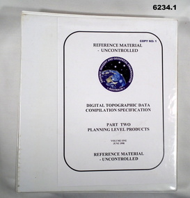
Manual - Digital Topographic Data Compilation Specification - Part 2 Planning Level Products, June 1998
The purpose of this document is to provide digital Topographic data compilation specifications for the Australian Defence Force (ADF) which are applicable to all areas of the Area of Direct Military Interest (ADMI) for the collection of features and attributes to populate the ADF topographic database.6234.1 A four ringed Folder containing A4 Paper, White, Metal Bindings, Chapters 1 to 8 6234.2 A four ringed Folder containing A4 Paper, White, Metal Bindings, Chapters 8 to 13 and Annexesroyal australian survey corps, rasvy, fortuna, army survey regiment, army svy regt, asr, director of survey - army -
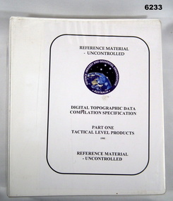 Bendigo Military Museum
Manual - Digital Topographic Data Compilation Specification - Part 1 Tactical Level Products, February 1995
These specifications enable the compilation of digital topographic data for the Australian Defence Force (ADF) to support the production of topographic information across a multiple product range covering Australia and its Area of Direct Military Interest (ADMI)A plastic covered four ring folder containing A4 paper, white, ten chapters, metal clip ringsroyal australian survey corps, rasvy, fortuna, army survey regiment, army svy regt, asr, director of survey-army -
 Bendigo Military Museum
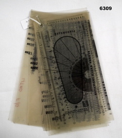
Equipment - Font -Type Style and Point Size Guide, Circa 1991
Also referenced in the Collections Victoria Bendigo RSL item 6300 Lithographic Squadron Equipment Handbook 1991. Commonly called a type styles guide, used for the selection and editing of text styles and size in mapping.20 Sheets of 21 x 11 cm clear photographic film (connected in the Top left hand corner) depicting various Type Font Styles and Point Sizes including special characters. It also contains a digital Type gauge, a linometer and a screen angle Indicator. royal australian survey corps, rasvy, fortuna, army survey regiment, army svy regt, asr -
 Bendigo Military Museum
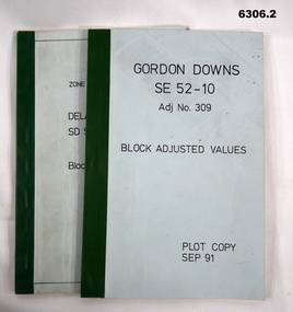
Administrative record - Report on the Block Adjustment of the Gordon Downs and Delemere 1:250,000 Maps, 1 Sep 1991, .2 Jan 1988
All mapping produced at this time were produced using Aerial Photography. These booklets contain the adjusted mathematical solution to joining this group of photographs together..1 Blue covered booklet with green tape binding. Block adjusted values for Gordon Downs SE 52-10 1:250 000 map Adjustment number 309 Sep 1991 .2 Blue covered booklet with green tape binding. Block adjusted values for Delamere SD 52-16 1:250 000 map Adjustment number 272 Jan 1988royal australian survey corps, rasvy, fortuna, army survey regiment, army svy regt, asr -
 Bendigo Military Museum
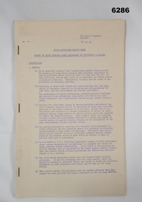
Administrative record - Report on Jerie Vertical Block Adjustment of the Townsville 1:250,000, 31 Oct 1963
Report describing the "Jerie" Vertical Block Adjustment for the Townsville 1:250,000 and how the apparatus was designed, constructed and used.Foolscap size, 14 x numbered pages and 10 x unnumbered pages. Stapled left side. Numbered pages printed in purple. Four of the unnumbered pages contain photos while the rest contain handwritten tables and hand drawn diagrams. Annex A: Discrepancies Tables, Annex B: Baseboard Diagram, Annex C to Annex G, Annex H: Photo showing tools which are numbered and listed below each photo. The numbers on each photo are faint but readable. royal australian survey corps, rasvy, fortuna, army survey regiment, army svy regt, asr -
 Warrnambool and District Historical Society Inc.
Map, Caramut township, 1938
This map of the township of Caramut was produced in 1938 but shows the original land owners of each town allotment and of the surrounding area. The size of all the allotments and the date of the original purchase are also shown. Caramut is a Victorian Western District town on Mustons Creek on the Hamilton Highway 48 kilometres from Warrnambool. This map was used by Rolf Crawley when he was the engineer for the Shire of Warrnambool from 1935 to 1968. The annotations on the map have probably been made by Rolf Crawley as they refer to the records and letter books of his father, John William Crawley, Junior (Shire of Warrnambool Engineer 1895 to 1935). Both Rolf Crawley and his father, John had private businesses as architects, surveyors and engineers and the map could have been used in connection with both their official Shire duties and their private businesses. The last owner of the map was the surveyor, Michael Hand who took over the business of Rolf Crawley in the late 1960s. This map is of great interest firstly because it has all the historical details of the land first purchased in the town of Caramut and area and secondly because it came from the office of Rolf Crawley, the engineer for the Shire of Warrnambool from 1935 to 1968. This is a buff-coloured paper map with a cloth backing. The map details are in black and white print. There are some handwritten red and black annotations on the map. “Town of Caramut Parish of Caramut County of Villiers’town of caramut, john william crawley junior, warrnambool, rolf crawley, warrnambool -
 Bendigo Military Museum
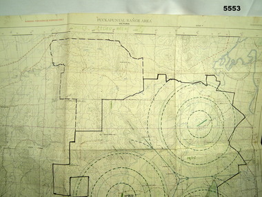
Map - MAP of PUCKAPUNYAL, 1958
Refer to Cat 5547, Matheson.This is a large map, printed in colour on one side only. Scale 1:25,999. The grid squares are 1000 x 1000 metres. it shows the camp, ranges and bush areas used by the military.This map is covered in a large number of added colour shadings, nav lines, airstrips and circles.puckapunyal army base, military training, map -
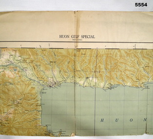 Bendigo Military Museum
Map - MAP, HUON GULF AREA, Aug 43
Refer Cat 5547 - Matheson.This is a single sided map, printed in colour. Scale 1:253,440, 4 miles to an inch, grid squares are 10mm x 10mm. Top right side shows Finschafen. Top centre is Lae, Middle is Salamau. Bottom is Lasanga Island. Top left vicinity is Nadzab and Markham River.There are four "corner" marks in pencil. Two on land and two out in the gulf.ww2, new guinea, map -
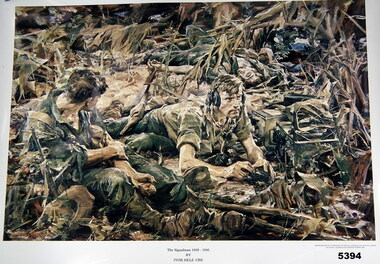 Bendigo Military Museum
Print - PRINT FROM ORIGINAL PAINTING, "The Signalman 1939-1945", 1985
Ivor Hele was the Australian Official War artist of WW2.Print on glossy paper. Colour copy of an oil painting. Two soldiers positioned within a jungle scene. Black printing below print of painting. Unframed.print, ww2, jungle -
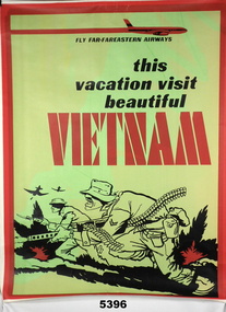 Bendigo Military Museum
Poster
Print on Poster " FLY FAR-FAREASTERN AIRWAYS/this /vacation visit/ beautiful/ VIETNAMPoster - white paper, black and red print, illustrated in black and red - stylized picture of two soldiers in a battle. Green and Yellow coloured background.poster, vietnam, travel -
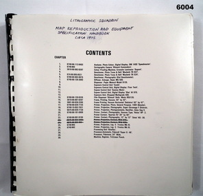 Bendigo Military Museum
Manual - Map Reproduction and Equipment Specification Handbook, Circa 1975
Manual used by Lithographic Technicians as a register of Map reproduction equipment. Possible uses include to identify and quantify available equipment as part of the stocktaking process.90 page technical manual/ handbook. Does not have a front cover. Contents page and pages within the document have black and white stock descriptions followed by photos of equipment. The manual is printed on photographic paper and is bounded by a black plastic spiral spline.royal australian survey corps, rasvy, fortuna, army survey regiment, army svy regt, asr -
 Bendigo Military Museum
Manual - DRAFT SPECIFICATIONS FOR TOPOGRAPHIC MAP SERIES, Specifications for 1:50000 and 1:25000 maps produced in Australia, Circa 1973
These draft Specifications set out the Standards for the production of topographic maps within the Commonwealth of Australia at scales of 1:50000 and 1:25000 and are designed to satisfy the basic requirements of both civil and military map users.Hard cover, cloth, Red, 11 Annexes, Supplementary documents.royal australian survey corps, rasvy, fortuna, army survey regiment, asr -
 Bendigo Military Museum
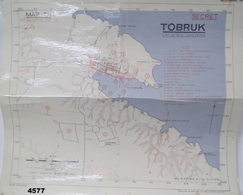
Map - MAP of TOBRUK HARBOUR, 48 Survey Coy S.A.E.C, C.1942
Item in the Doug Dean 2nd AIF collection, refer cat No 4575PMap, laminated, “MAP T/1 SECRET TOBRUK”, shows Tobruk area and harbour, shows creeks, gullies, there are 20 marked installations in red, a rectangular section has been hand drawn on marked “E” & “F”,.At bottom RH corner, “HQ, RAF, ME, A1, 16 JULY 1942”tobruk, maps, ww2 -
Federation University Historical Collection
Booklet, Preserving Our Archaeological Heritage
Nine page booklet with a ohotograph of a buried dingo skeleton on the cover. contents include: * Legislation Relating to Aboriginal Relics * Register of Aboriginal Sites * Site protection and Preservation * Archaeological Research * Coastal midden * Lake Condah * Archaeological Relics Advisory Committee * Community Education, Training and Information * What to do when youfind a relicarchaeology, victorian archaeological survey, aboriginal sites, aboriginal statements, register of aboriginal sites, glenaire rock shelter, lake condah fish trap, st arnaud rock wells, carisbrook archaeological area -
Federation University Historical Collection
Booklet - Book, Burra Lotjpa Dunguludja: Victorian Aboriginal Justice Agreement Phase 4, 2018
Burra Lotjpa Dunguludja means 'Senior Leaders Talking Strong' in Yorta Yorta language.Sixty page book aiming to continue to address Aboriginal over-representation across the justice system, and to progress self-determination as the core policy approach. The vision was to ensure Aboriginal people have access to n equitable justice system that is shaped by self-determination, and protects and upholds their human, civil, legal and cultural rights.aboriginal, martin pakula, tont lovett, marion hansen, aboriginal justice, aboriginal justice caucus, message stick, koori justice unit -
 Bendigo Military Museum
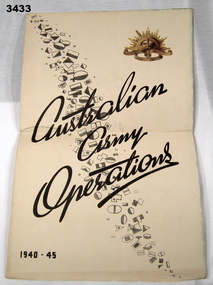
Poster - CHART WW2, ARMY OPERATIONS, A Chart of Australian Army Operations 1940 -1945, Post WW2
Strong paper chart folded 3 times. Front panel has title Australian Army Operations 1940 - 1945 printed in black ink, black & white divisional unit colour patches & gold coloured Rising Sun. Inside are 4 maps including Mediterranean Sea area, New Guinea, Pacific Islands - Borneo & Malaya. One panel has a chronology chart showing dates & events during 1939 - 1945.chart, operations, army 1939 - 45 -
 Bendigo Military Museum
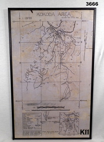
Map - MAP, KOKODA MOUNTED, 4.9.1942
Map was compiled from aerial photos without ground control or inspection & with information received from Major CAMERON.Laminated map of Kokoda area on board backing with black border. Black printing on cream / fawn background. White hanging strap on back. Information ledger bottom LHS. Kokoda inset bottom RHS.Printed at top: “KOKODA AREA” Printed at bottom “RHS: K11”map, kokoda, mounted