Showing 2103 items
matching structures
-
 Kew Historical Society Inc
Map, MMBW, MMBW Plan No.64 Kew & Heidelberg, 1900-1910
The Melbourne and Metropolitan Board of Works (MMBW) was established by an act of the Victorian Parliament in 1890 to prepare for and to implement a sewerage and water reticulation system across what was then inner Melbourne, its surrounding and middle distance suburbs, including Kew. The MMBW was disbanded in 1991.The map collection of the Kew Historical Society has at its core the historic maps assembled and originally stored in the City Engineer's Department of the City of Kew. These include maps in a number of scales. The vast majority of maps were produced by the MMBW in the first two decades of the twentieth century, and are solid working maps, backed by linen for durability. These maps are historically significant to Kew, the City of Boroondara and to the history of the development of state utilities in Victoria. A number of the Kew maps have additional details added by former municipal officers, including the levels reached by various floods. As these were working documents, information was added to them long after the period of their initial production and distribution.Early map of part of the Borough of Kew, created in the first decade of the twentieth century, at a scale 160 ft to 1 inch. The map covers what was then the northern most part of Kew, bordered on its north and west by the Yarra River, in the East by Connor's Creek and by the Asylum in the south. The map shows the extent of urban development by that time, prominent institutions and the outlines of built structures in the municipality. Contour lines and historic flood levels were added in ink to the map at a later stage.MELBOURNE AND METROPOLITAN BOARD OF WORKS / PLAN NO. 64 / KEW & HEIDELBERGmelbourne & metropolitan board of works, mmbw maps, mmbw plans, borough of kew, cartography -
 Kew Historical Society Inc
Map, MMBW, MMBW Plan No.65 Kew & Heidelberg, 1900-1910
The Melbourne and Metropolitan Board of Works (MMBW) was established by an act of the Victorian Parliament in 1890 to prepare for and to implement a sewerage and water reticulation system across what was then inner Melbourne, its surrounding and middle distance suburbs, including Kew. The MMBW was disbanded in 1991.The map collection of the Kew Historical Society has at its core the historic maps assembled and originally stored in the City Engineer's Department of the City of Kew. These include maps in a number of scales. The vast majority of maps were produced by the MMBW in the first two decades of the twentieth century, and are solid working maps, backed by linen for durability. These maps are historically significant to Kew, the City of Boroondara and to the history of the development of state utilities in Victoria. A number of the Kew maps have additional details added by former municipal officers, including the levels reached by various floods. As these were working documents, information was added to them long after the period of their initial production and distribution.Early map of part of the Borough of Kew, created in the first decade of the twentieth century, at a scale 160 ft to 1 inch. The map covers what was then the south central part of Kew, bordered on its north by Malmsbury Street, in the west by Florence Avenue, in the south by Barkers Road, and in the east by Princess Street. The map shows the extent of urban development by that time, prominent institutions and the outlines of built structures in the municipality. Contour lines were added in ink to the map at a later stage.MELBOURNE AND METROPOLITAN BOARD OF WORKS / PLAN NO. 65 / KEW & HEIDELBERGmelbourne & metropolitan board of works, mmbw maps, mmbw plans, borough of kew, cartography -
 Kew Historical Society Inc
Map, MMBW, MMBW Plan No.66 Kew, 1900-1910
The Melbourne and Metropolitan Board of Works (MMBW) was established by an act of the Victorian Parliament in 1890 to prepare for and to implement a sewerage and water reticulation system across what was then inner Melbourne, its surrounding and middle distance suburbs, including Kew. The MMBW was disbanded in 1991.The map collection of the Kew Historical Society has at its core the historic maps assembled and originally stored in the City Engineer's Department of the City of Kew. These include maps in a number of scales. The vast majority of maps were produced by the MMBW in the first two decades of the twentieth century, and are solid working maps, backed by linen for durability. These maps are historically significant to Kew, the City of Boroondara and to the history of the development of state utilities in Victoria. A number of the Kew maps have additional details added by former municipal officers, including the levels reached by various floods. As these were working documents, information was added to them long after the period of their initial production and distribution.Early map of part of the Borough of Kew, created in the first decade of the twentieth century, at a scale 160 ft to 1 inch. The map covers what was then the south eastern part of Kew, bordered on its north by Adeney Avenue, in the west by Sackville Street, in the south by Barkers Road, and in the east by Burke Road. The map shows the extent of urban development by that time, prominent institutions and the outlines of built structures in the municipality. Contour lines were added in ink to the map at a later stage.MELBOURNE AND METROPOLITAN BOARD OF WORKS / PLAN NO. 66 / KEW melbourne & metropolitan board of works, mmbw maps, mmbw plans, borough of kew, cartography -
 Beechworth Honey Archive
Extractor
Frames are uncapped with an uncapping knife, and placed into a holding spot or basket. The handle is then turned, spinning the frames inside. Eventually, the centrifugal force drains the honey from the frames. The honey can be poured from the drum via the tap. The empty frames go back into beehives to be filled with honey again.Antique two frame manual extractor. Metal 44 gallon drum with external tap, handle and hole. Inside; rotating two-frame honey extractor. The two frames are attached to a square metal structure. Each frame is only attached by one end. Each frame is a rectangular metal construction with square wire panels on two sides. Internal frame rotates freely. Other two sides and base solid. On top of drum is a hand-driven metal crank for turning internal frames.two, frame, hand, manual, extractor, honey, beechworth honey -
 Bacchus Marsh & District Historical Society
Photograph, Family group and farm house near Bacchus Marsh 1883
This image is one of several family group portraits taken by Stevenson and McNicoll on what appears to be a rural property. The identity of this family group and the location where the image was taken has not been identified. It is presumed to be in the Bacchus Marsh district and dates from around September-November 1883. The composition of the group appears to be a father and mother with three adult daughters.Small sepia unframed photograph on card with gold border framing photograph. Housed in the album, 'Photographs of Bacchus Marsh and District in 1883 by Stevenson and McNicoll'. The image shows a family group of four women and one man. They are standing in a single row in front of a farm house. The family in this image and the precise location of the property have not been identified. The house in the background is a single storey timber structure with a shingled roof and a verandah at the front. Two chimneys can be seen attached to the house.On the front: Stevenson & McNicoll. Photo. 108 Elizabeth St. Melbourne. COPIES CAN BE OBTAINED AT ANY TIME. On the back: LIGHT & TRUTH inscribed on a banner surmounted by a representation of the rising sun. Copies of this Portrait can be had at any time by sending the Name and Post Office Money Order or Stamps for the amount of order to STEVENSON & McNICOLL LATE BENSON & STEVENSON, Photographers. 108 Elizabeth Street, MELBOURNE. stevenson and mcnicoll 1883 photographs of bacchus marsh and district, farmhouses, families -
 Port of Echuca
Colour Photograph, Approx. 1979
Formerly the home of Henry Hopwood. Apsley House, No. 1 Echuca. This was purchased for the Bridgine nuns to establish a catholic co-education school in Echuca. Extensions were made to the original structure (to the south of this building) with outbuildings and brick stables converted to school rooms during the late 1886 and opened as St Joseph's in 1887. The front section of the school was built in 1888. At the time of this photograph the upper floor of the building was the boarding house. The school building holds historical, social and spiritual significance to Echuca being the former home of Echuca's founder, Henry Hopwood. The diocese purchased the original building for 1,000 pounds. The school opened as a co-educational school on 22/3/1886 with 16 boys and 7 girls. It's first enrolment was a non-Catholic boy. By the end of 1886 there were 30 pupils. The boarding school opened on 4/5/1886 with 6 students. The chapel (to the north of this building) was built in 1889. For 60 years the school provided both primary and secondary schooling but in 1960's it changed to secondary schooling. The boarding house closed around 1986 and the school continued as a co-educational catholic college.Colour photograph (post-card size) of Bridgine Convent, Echuca (St.Joseph's College), showing arched facade over the verandah and the upper louvred windows of the boarding house.On front above the entrance "Brigidine Convent A.D. 1886.. Printed on the reverse:" this paper manufactured by Kodak"echuca- secondary schools, st joseph's college, echuca, brigidine convent, echuca -
 Eltham District Historical Society Inc
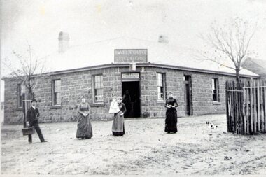
Photograph, Royal Mail Hotel, Diamond Creek; destroyed by fire, 1925
This hotel was located in Chute Street Diamond Creek. The site was from the C.F.A. station east to the corner. In 1925 this hotel was burnt down at 11.00 am on a week day and the street was closed by police because the lighting system used petrol gas and an explosion was feared. Fortunately there was no explosion. This photo shows the gutted structure after the fire. Yarra Plenty Regional Library https://yprl.bibliocommons.com/item/show/485980027_royal_mail_hotel,_diamond_creekBlack and white copy of photo printed on glossy photographic paper 30.5 x 40.5 cm (12 x 16 inch); image size approx. 18.5 x 28 cmchute street, diamond creek, fire damage - buildings, royal mail hotel -
 Eltham District Historical Society Inc
Document - Folder, Census information, 1983
Report of population and dwelling characteristics from the 1971 Census relating to the Shire of Eltham. Comparative population statistics about the Shire of Eltham, August 1983. Historical population growth for the Shire of Eltham 1871-1981 Comparison of 1976 and 1981 populations by age group, population by urban area, age structure, number of dwellings, family type, households and more Part of Folder 75 from Harry Gilham Collection 4 A4 pages (photocopies), 2 printed A4 pages and 2 printed maps (A3) folded. 5 pages headed September, 1983population, statistics, census, shire of eltham -
 Warrnambool and District Historical Society Inc.
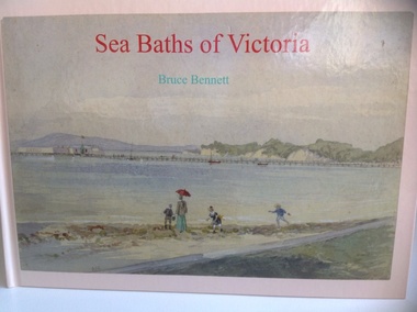
Book, Sea Baths of Victoria, 2013
History of sea baths in Victoria.Hardback, landscape book with watercolour painting of Sea baths at Sorrento looking east by AC Clarke on the front. Also the title in red and author Bruce Bennett in aqua. The spine has the title and author as above. On the back cover are six reproductions of sea baths and synopsis of the book. 152 pages of white, gloss paper, acknowledgements, contents, preface, 5pages of References and a 2 page Index. The end papers are of white paper. non-fictionHistory of sea baths in Victoria.sea water baths, victoria, bruce bennett, warrnambool, windmill, 1890, swimming, closed 1960s, bathing boxes, poster, warrnambool baths company, 1877 -
 Rutherglen Historical Society
Images, 1960s
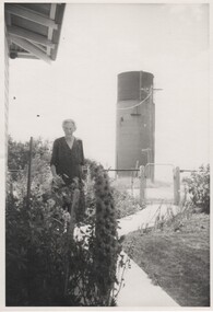
One of a collection of photographs from the Iggsten Estate. The water tower in the background is located in Hunter Street and was built in 1899-1900 to serve as the town's water supply. A new reservoir was built in 1945 with water being pumped from the Murray. A steel mesh structure, to make it look like a wine bottle, was added to the top in 1969 with funds from the Rutherglen Wine Festival. The woman in the photograph may be Florence Iggsten. Black and white photograph of a woman standing in a front garden, with a view of a water tower in the background.florence iggsten, water tower, wine bottle, tourism -
Unions Ballarat
Ledger. Political Labor Council of Victoria, Ballarat Branch, March 1911-August 1912
The ledger is part of the financial recordkeeping of the Political Labor Council of Victoria, Ballarat Branch. Constitution of the Political Labor Council of Victoria can be found at http://tinyurl.com/politicallabourcouncilvic. It had platforms at federal, state and municipal levels. The state platform includes land policy, financial policy including restriction of public borrowing, reform of parliamentary structure, industrial regulation, free education, support for technical education and adequate pensions.Constitutes part of the history of the Political Labor Council of Victoria. Financial transactions. Paper ledger - one volume.political labor council of victoria - ballarat branch, btlc, ballarat regional trades and labour council, finance - record keeping -
 Sunbury Family History and Heritage Society Inc.
Photograph, Ball Court Hotel
The hotel was built some time shortly after 1842 by John Cahill, who arrived in the colony in 1842 from Thurles in Tipperary, Ireland. The building although much altered with render covering the original \blue stone structure is on the south-west corner of Macedon and Jackson Streets. The hotel was called the Ball Court because Cahill also had a hand-ball court set up behind the hotel.Originally five hotels were built along Macedon Street between Jackson Creek and Evans Street. The Ball Court Hotel is the only one still standing and operating as a hotel.A non-digital black and white photograph with a cream border of man and three ladies standing outside a single story blue stone hotel building with a corner entrance. AS well as the corner entrance there is another doorway on the RHS along with three narrow windows and three other windows on the other side. One of the ladies is holding a little child. Two trees surrounded by tree guards are on each side of the photograph.Ball Court Hotel, John Cahillball court hotel, hotels, sunbury, macedon street, jackson street, ball court -
 Surrey Hills Historical Society Collection
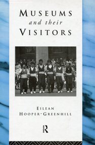
Book, Museums and their visitors, 1994
Museums are changing from being static storehouses for artefacts into active learning environments for people. New forms of museums, new ways of working with objects, new attitudes to exhibitions and above all, new ways of relating to museum publics, are emerging. At the end of the twentieth century, old structures are being replaced to prepare for a new century. Many social institutions are reviewing their roles and potentials, and museums and galleries are among them.incl. bibliographical references; 213p; endpaper: Susan Barnett museums -
![Painting - Artwork, Rodney Forbes et al, [Printery], c1982](/media/collectors/530576742162ef0fa09a2288/items/57ecace9d0cdd12be41850de/item-media/57ecad44d0cdd12be4188585/item-fit-380x285.jpg) Federation University Art Collection
Federation University Art CollectionPainting - Artwork, Rodney Forbes et al, [Printery], c1982
Rodney FORBES (1951- ) Born Melbourne Rodney Forbes' work is figurative narrative painting and uses autobiographical and incident-as-metaphor methods to explore wider issues of knowing and belonging in oral traditions such as working class, children’s and artisan subcultures. His practice draws on pop, cartooning and joke narrative structures within contemporary culture. (http://www.australiangalleries.com.au/artists/rodney-forbes/, accessed 07 April 2017)A large painting showing aspects of a printery. Rodney Forbes and fellow student Linda Karklins worked on this painting as an undergraduate student at the Gippsland School of Art (Gippsland Institute of Advanced Education, now the Gippsland Centre for Art and Design, Federation University Gippsland Campus). The painting hung for many years in the campus printery. The Gippsland Gippsland Centre for Art and Design is now part of Federation University Gippsland Campus.rodney forbes, printery, gippsland campus, churchill, linda karklins, gippsland school of art, gippsland institute of advanced education, printing -
 Melbourne Tram Museum
Document, The Met, "Overhead Appreciation - draft", 2/1995
Document - full title "Met Tram Overhead appreciation for Met Tram Officers & Tram Drivers" Gives a detailed inforamation on the structure of the tram overhead, its parts, poles, such as frog pans, crossing pans, points, contactors ,broken trolley wire, pantograph operation and feeder cables. Has notes on the SCADA system and Carlton Electrical control system. Written at the time when trolley poles remained in operation.Yields information about the Melbourne tramway overhead system.Document 47 A4 pages, clear plastic cover, with card covers comb bound along top edge.tramways, tramcars, equipment, overhead, electrical engineering, trolley wire -
 Melbourne Tram Museum
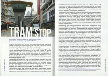
Book - The Scots Church - The Leaflet Spring 2022, Michael North - Scots Church, "Tram Stop", Sept 2022
Tram Stop article written by Michael North looks at the structure at the Elizabeth St tram terminus, named after Sir Robert Risson and his convictions to support the Melbourne tramway system including the campaigns to replace Melbourne's iconic trams with buses and motor cars. Has a photo of the terminal building by Mal Rowe - Sir Robert Risson Tram Terminus. The rear cover image of La Trobe St.Yields information about the Elizabeth St tram terminus and its memorial to Sir Robert Risson, MMTB Chairman 1949 to 1970,Book - magazine - 48 pages, perfect bound, full colour titled The Scots Church - The Leaflet Spring 2022 containing an article on the Robert Risson Tram Stop at the Elizabeth St tram terminus.trams, tramways, robert risson, elizabeth street, memorials -
Unions Ballarat
Book - Politics in Australia (3rd ed.), Smith, Rodney
Structure of Australian politics and parliamentary process and associated issues. Chapter titles: Introduction: Using this book and finding other resources on Australian politics / Rodney Smith 1. The nature of politics / Helen Pringle 2. Power / Rodney Smith 3. Democratic theory and practice / Michael Jackson 4. Public policy-making / Martin Laffin 5. Australian political thought / Ian Cook 6. The Constitution / Elaine Thompson 7. Parliament / Marcus Haward 8. Cabinet / Barbara Page 9. The public service / Elaine Thompson 10. The party system / Rodney Smith 11. Elections / Martin Painter 12. Federalism / Martin Painter 13. State politics / Helen Nelson 14. The structures of inequality / Michael Hogan 15. Gender and patriarchy / Vanessa Farrer 16. Interest groups / Trevor Matthews 17. Business and politics / John Ravenhill 18. Trade unions / Marian Simms 19. The news media / Rodney Smith 20. The Australian voters / Ernie ChaplesRelevant to democracy, politics and the trade union movement in Australia.Book; paper.Cover: editor's name and title. Cover page: in blue ink, "David Cadby". (Includes postal address and telephone number.)btlc, ballarat trades and labour council, politics and government, trade unions -
NMIT (Northern Melbourne Institute of TAFE)
Book: TAFE colleges management study: report to the Chairman of the TAFE Board, Victoria 1985
Report of 302 pages, published in March 1985 by Cullen Egan Dell Australia Pty. Ltd. ISBN 0724126554. The study was conducted to examine organisational requirements for the TAFE college system in Victoria. Conclusions and recommendations are included. The project team was asked to provide: a rationale for the organisation of TAFE colleges; a number of detailed structures and arrangements; a comprehensive position specification for the chief executive of a TAFE college; comprehensive position specifications for senior management positions in TAFE colleges; identification of organisational relationship issues and proposals to address them; and strategies for the implementation of organisation proposals. The team examines in detalis the arrangements within six TAFE colleges selected to provide a representative sample of the total network in Victoria. Although many positive features of TAFE in Victoria were noted, the team concluded that significant problems existed in the system at this time and that these impair the capacity of TAFE to operate in a fully efficient and effective way. A range of strategies are proposed to address these concerns along with new management structures and arrangements for colleges designed to meet the current and future needs of the community more effectively.tafe board victoria, nmit -
 Sunbury Family History and Heritage Society Inc.
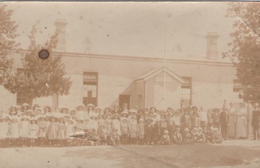
Photograph, Sunbury State School
The first building which housed Sunbury State School No.1002 was built on the corner of Macedon and Stawell Streets in the early 1870s and functioned as the local State School until 1912 when a sturdier red brick structure replaced on the same site. In 1999 Sunbury State School was relocated in the former Industrial School heritage buildings in Jacksons Hill. The existing building in Macedon Street was incorporated into the Sunbury Community Health Centre. The school in the photograph is the original Sunbury State School NO. 1002 building, where many early Sunbury residents attended. A non-digital black and white photograph in post card format of a crowd of children outside a school building. Four teachers are standing on the RHS of the image.sunbury state school no. 1002, stawell street, macedon street, schools -
 Eltham District Historical Society Inc
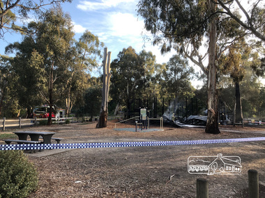
Photograph, Vicki Ward, Day breaks over the destroyed Adventure Playground at Eltham North, 16 December 2017
A community group project steered by Bambi McLean led to the construction of the Eltham North Adventure Playground which opened off Wattletree Road in 1995. The structure was mainly wooden and included an undercover element with slides and areas to climb. It was destroyed by fire in the early hours of 16 December 2017. These phtoos of the aftermath were taken at approx. 6:45am in the morning by Vicki Ward, MP for Eltham A new adventure playground was built in 2018. Digital fileeltham north, north eltham adventure playground, arson, wattletree road -
 Kiewa Valley Historical Society
Photographs – Set of 4 black and white photographs. One of a wooden church and three of rural homes and farmland. Area not identified
Europeans arrived in the Kiewa and Ovens Valleys in the 1830's and 40's. Following the drought of 1838-44, seeking out the rich pastures in the fertile Valleys. It proved to be perfect conditions for dairy farming and the raising of cattle. Miners Cottages and other similar wooden structures were a common sight in the area as they were a modest form of accommodation for their period, were quick to erect and economical as they made use of locally available building materials such as local timbers.These photographs provide a snapshot into the early dwellings and architecture of the Kiewa and Ovens Valley regions, including buildings such as the church, which provided an important gathering place for social interaction, especially in these isolated areas.1-Wooden church building with no identification. Large tree in the foreground in front of church 2&3- Black and white photographs of farmland and assorted dwellings, mostly miners style cottages in a valley with mountains in the background. A bridge with wooden railings is visible over the river in the middle of the photograph, also a more modern dwelling is visible in the north east of the photograph close to the river. 4-Black and white photograph of residential homes and farmland with an unsealed road running through the middle. Foreground shows a field which has been semi cleared of trees (stumps remaining). In the background are larger farming properties with the road disappearing into the distant hills. This might be Old Tallangatta before the town was moved in 1956. 1-3 - No inscriptions 4- Signature written on back in lead pencil - Sandra Templebuildings; church; farmland -
 Federation University Historical Collection
Photograph - Photograph (black & White), Ballarat School of Mines from Albert Street, c1936
The Ballarat School of Mines was the first of its type in Australia. The Albert Street frontage was the 'working end' of the campus with the mining laboratory, gauge tower and caretakers cottage. All the structures in the foreground have been demolished to make way for the Flecknoe Building and the M.B. John Building. Harry Brew, the well known Ballarat School of Mines caretaker, lived in the small weatherboard building to the right of the photograph. He was appointed to the staff at the Ballarat School of Mines in 1936.Black and white photograph showing the Ballarat School of Mines from Albert Street. Henry Richards Caselli's Gauge Tower is in the foreground. To its left is the Mining Laboratory, and to it's right is the caretakers cottage.verso 'SMB. Albert St frontage, showing (Harry Brew's) edge of his cottage. harry was a likeable character in his day, he was an old sailor boy, served, on HMAS Physice, & was an expert in , bugs and such like, crawling beasties (signature undecipherable)ballarat school of mines mining laboratory, caretaker's cottage, harry brew, henry caselli, hr caselli henry richards caselli -
 Federation University Historical Collection
Photograph - Photograph - Black and White, Ballarat College of Advanced Education, Mt Helen - 1985, 1985
Photograph of the early years of the Ballarat College of Advanced Education at Mt Helen. On the left is the first stage of the student accommodation with a bridge connecting it to the campus. The car park located near the lakes is next to the Physical Education building. This is before the swimming pool has been added. The building with large white external structure is the E.J.Barker Library before the top floor has been built. This floor is where the Geoffrey Blainey Research Centre is housed.Photograph mounted on heavy white card which is then mounted onto black board. Aerial photograph of Ballarat College of Advanced Education at Mt Helen.ballarat college of advanced education, student accomodation, physical education, swimming pool, e j barker library, geoffrey blainey research centre, student residences -
 Federation University Historical Collection
Architectural Plan, Ballarat School of Mines Gauge Tower Architectural Plan, c1883
The Ballarat School of Mines was the first of its type in Australia. The Albert Street frontage was the 'working end' of the campus with the mining laboratory, gauge tower and caretakers cottage. All the structures in the foreground have been demolished to make way for the Flecknoe Building and the M.B. John Building. Harry Brew, the well known Ballarat School of Mines caretaker, lived in the small weatherboard building to the right of the photograph. He was appointed to the staff at the Ballarat School of Mines in 1936.Printed copy of an architectural plan for the Ballarat School of Mines Gauge Tower as printed in the 1879 Ballarat School of Mines Annual Report.henry caselli, henry richards caselli, architectural plan, ballarat school of mines, gauge tower -
 National Wool Museum
Newspaper Cutting, Messrs. C. J. Dennys and Co.'s New Wool Store Geelong, 10/9/1872
The Denny Lascelles Wool Warehouse was the first building in Victorian planned to facilitate storage, inspection and marketing of wool in one operation, and upon completion was the second largest store in the colony. CJ Denny's was largely responsible for establishment and development of the wool marketing industry in Geelong and is a figure of significance in the history of settlement in Geelong. The wool store, a basalt structure with cement rendered ornamentation, was erected for CJ Denny's and Co, in 1872 to the design of Jacob Pitman, Architect.Wood cut engraving of the Mesrs. C. J. Dennys and Co.'s New Wool Store Geelong, published in The Illustrated Australian News, 1872. The half page full colour illustration shows the newly constructed Wool Store with a bull drawn cart carrying full wool bales situated out the front of the store.Top margin: THE ILLUSTRATED AUSTRALIAN NEWS 201 Below image: Mesrs. C. J. Dennys and Co.'s New Wool Store Geelong Image signed, lower mid edge: WINSTON Image, on building: C.J. Dennys Wool Brokers 1872 C.J. Dennys & Co. Wool & Produce Warehousedenny lascelles wool warehouse, wool, dennys, wool store -
Australian Nursing & Midwifery Federation
44-minute video documentary on 1986 Victorian nurses strike, Running out of patience : the 1986 Victorian nurses strike, 1988
In October 1986, Victorian nurses began an historic strike action which was to last 50 days. This video is the nurses version of the dispute. Despite widespread condemnation mainly from the media, the nurses eventually won out for an appropriate career structure including significant pay increases. Actual strike footage together with nursing training films and old photographs explore vocational stereotypes and place the strike in the context of the current crisis in the health care system.44 minute video file (.mp4 multimedia format), transferred from original videocassette. In colour, with sound. Original was released with a booklet explaining the broader context for the documentary.labor, labour history, nurses, royal australian nursing federation, strikes, industrial action, film, trade unions, 1986 victorian nurses strike, nursing, strike action, unionism, campaigning, victoria, health system, staffing, australia, irene bolger, strikes and lockouts, history -
 Parks Victoria - Wilsons Promontory Lightstation
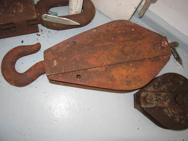
Sheave Block/Pulley
Pulleys were used to lift goods to and from boats and at other sites at the lightstation where hauling was undertaken. Historical images and text panels in the Wilsons Promontory Museum attest to the detailed logistics that needed to be exercised in lifting and transporting goods once they had arrived by boat at the Eastern Landing. Cranes and a flying fox were employed in the nineteenth century and updated versions of this equipment served well into the twentieth century. The first cranes to be employed at the site were built just after December 1857, when tenders were called to construct two cranes prior to the commencement of building the lightstation.The first boat landing at the promontory was built on the west side of the lighthouse, which the architect, Charles Maplestone sketched in June 1859, the same month that he announced the completion of the lighthouse. His drawing shows one of the cranes as a large structure built for heavy duty lifting. Soon the east landing became the preferred place for delivering stores, but as late as 1993 a crane, timber structures and disused heavy iron machinery remained at the old site.Large rusted iron pulley, large loop at one end and smaller loop at the other. No hook.(Sheave Block) -
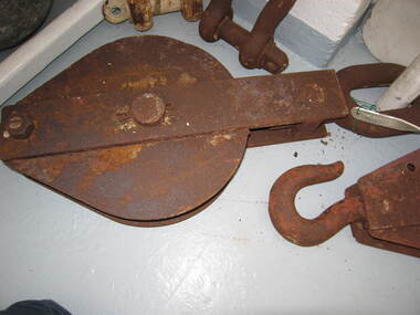
 Parks Victoria - Wilsons Promontory Lightstation
Sheave block/ pulley
Pulleys were used to lift goods to and from boats and at other sites at the lightstation where hauling was undertaken. Historical images and text panels in the Wilsons Promontory Museum attest to the detailed logistics that needed to be exercised in lifting and transporting goods once they had arrived by boat at the Eastern Landing. Cranes and a flying fox were employed in the nineteenth century and updated versions of this equipment served well into the twentieth century. The first cranes to be employed at the site were built just after December 1857, when tenders were called to construct two cranes prior to the commencement of building the lightstation.180 The first boat landing at the promontory was built on the west side of the lighthouse, which the architect, Charles Maplestone sketched in June 1859, the same month that he announced the completion of the lighthouse.His drawing shows one of the cranes as a large structure built for heavy duty lifting. Soon the east landing became the preferred place for delivering stores, but as late as 1993 a crane, timber structures and disused heavy iron machinery remained at the old site.Large iron pulley with loop at one end and hook at the other, rusted. -
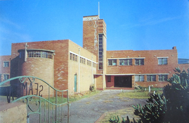 Mission to Seafarers Victoria
Postcard - Postcard, Colour, Alison Kelly, c. 1990
Also known as the King George V memorial building this branch of the Mission to Seamen opened in 1937 as a replacement for the old Mission in Port Melbourne. The Foundation stone was laid by the Victorian State Governor and a photograph of the event is also held in the MTSV collection. The Art Deco style building was commissioned by merchant and philanthropist, Alfred Michael Nicholas (1881-1937) and designed by prolific Melbourne-based architect Harry A. Norris (1888-1966) in 1937 best known for his commercial work in Melbourne city centre. NB PMHPS Kindly allowed MTSV heritage to take scans of the Kelly series notes in their collection for reference in 2019.One of the few full colour images of this building originally classified by the National Trust and now demolished. An example of architect Harry Norris' work 1937. All that remains are a ceramic plaque, a brick and several items of chapel artefacts. Alison Kelly, a photographer, was part of the group supporting the Port Melbourne Seamen's Mission in the 1980s and 1990s. She took a series of photographs of the building now held by the Port Melbourne Historical and Preservation Society.Full colour Postcard featuring colour image of a large red brick building in a 1930s era Architecture. There is a green wrought iron gate ajar in the foreground with the word SEAMAN spelled out. MISSIONS TO SEAMEN can also be seen spelled ut in white across and down the central clock tower of the building and this is surmounted with a white flagpole.On verso: Printed: "Heritage Series / POST CARD " at right angles in small print from lwr edge to upper: "PHOTOGRAPHY BY ALISON KELLY PORT HERITAGE SERIES NO 6". At Lwr left crnr printed:" Missions to Seamen Building, Port Melbourne/ Designed in the Modern style by architect Harry Norris,/ this 1937 National Trust classified structure was until 1972 / an entertainment and spiritual centre for seamen, with / important roles during the war [WW2] and immigration periods"king george v, memorial chapel, harry a. norris, brick, art deco, alfred m. nicholas, beach street, mission to seamen, alison kelly, 1937, arts centre, seamen mission, mission to seafarers, port melbourne -
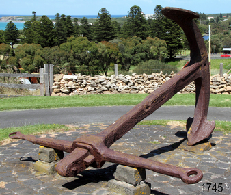 Flagstaff Hill Maritime Museum and Village
Equipment - Anchor, Circa 1886
The anchor is one of four that were carried by the FALLS OF HALLADALE when she was wrecked near Peterborough in 1908. This Rodger’s Anchor was raised from the wreck site by Flagstaff Hill divers (Peter Ronald, Colin Goodall and Gary Hayden) in 1974 and is on permanent outdoor display at the Maritime Village. The imposing 2-tonne artefact required a raft of fourteen 44-gallon drums to raise it from the seabed before it was towed by a crayfish boat to the wharf crane at Port Campbell for loading onto land transport. Following Lieutenant William Rodger’s patent in 1831, anchor design moved away from the separate attachment of straight arms and flat flutes to each side of a long shaft. Rodger’s innovation included the forging of both arms and their flutes as a single uniformly curved piece which was then attached to the crown of the shank by a thick horizontal bolt. The two-inch diameter hole for the securing through-bolt at the crown is clearly visible in this example, the bolt dislodged by corrosion and now missing. The FALLS OF HALLADALE was a four-masted, iron-hulled barque, built by Russell and Co at Greenock in 1866 for the Falls Line of Wright & Breakenridge, Glasgow. The ship was 275 feet long, 42 feet wide, with a 24 feet draft and weighed 2,085 tonnes. She was built to carry as much cargo as possible rather than for speed. Her unmistakably square bilge earned her the title of “warehouse-type” ship and her iron masts and wire rigging enabled her to maintain full sail even in gale conditions. In 1908, with new sails, 29 crew, and 2800 tons of cargo in her hold, the FALLS OF HALLADALE left New York, bound for Melbourne and Sydney via the Cape of Good Hope. 102 days later, at 3 am on the 14th of November, under full sail and in calm seas, with a six knots breeze behind and a misleading fog along the coast, the great vessel rose upon an ocean swell and settled on top of a shelf of rock near Peterborough. There she stayed for nearly two months until the pounding seas and dynamiting by salvagers finally broke her back, and her remains disappeared back into deeper water. The iron-hulled, four-masted barque, the Falls of Halladale, was a bulk carrier of general cargo. She left New York in August 1908 on her way to Melbourne and Sydney. In her hold, along with 56,763 tiles of unusual beautiful green American slates (roofing tiles), 5,673 coils of barbed wire, 600 stoves, 500 sewing machines, 6500 gallons of oil, 14400 gallons of benzene, and many other manufactured items, were 117 cases of crockery and glassware. Three months later and close to her destination, a navigational error caused the Falls of Halladale to be wrecked on a reef off the Peterborough headland at 3 am on the morning of the 15th of November, 1908. The captain and 29 crew members all survived, but her valuable cargo was lost, despite two salvage attempts in 1908-09 and 1910. ABOUT THE ‘FALLS OF HALLADALE’ (1886 - 1908) Built: in1886 by Russell & Co., Greenock shipyards, River Clyde, Scotland, UK. The company was founded in 1870 (or 1873) as a partnership between Joseph Russell (1834-1917), Anderson Rodger and William Todd Lithgow. During the period 1882-92 Russell & Co., standardised designs, which sped up their building process so much that they were able to build 271 ships over that time. In 1886 they introduced a 3000-ton class of sailing vessel with auxiliary engines and brace halyard winches. In 1890 they broke the world output record. Owner: Falls Line, Wright, Breakenridge & Co, 111 Union Street, Glasgow, Scotland. Configuration: Four-masted sailing ship; iron-hulled barque; iron masts, wire rigging, fore & aft lifting bridges. Size: Length 83.87m x Breadth 12.6m x Depth 7.23m, Gross tonnage 2085 ton Wrecked: the night of 14th November 1908, Curdies Inlet, Peterborough south west Victoria Crew: 29 The Falls of Halladale was a four-masted sailing ship built in 1886 in Glasgow, Scotland, for the long-distance cargo trade and was mostly used for the Pacific grain trade. She was owned by Wright, Breakenridge & Co of Glasgow and was one of several Falls Line ships, all of which were named after waterfalls in Scotland. The lines flag was of red, blue and white vertical stripes. The Falls of Halladale had a sturdy construction built to carry maximum cargo and able to maintain full sail in heavy gales, one of the last of the ‘windjammers’ that sailed the Trade Route. She and her sister ship, the Falls of Garry, were the first ships in the world to include fore and aft lifting bridges. Previous to this, heavily loaded vessels could have heavy seas break along the full length of the deck, causing serious injury or even death to those on deck. The new, raised catwalk-type decking allowed the crew to move above the deck in stormy conditions. This idea is still used today on the most modern tankers and cargo vessels and has proved to be an important step forward in the safety of men at sea. On 4th August 1908, with new sails, 29 crew, and 2800 tons of cargo, the Falls of Halladale left New York, bound for Melbourne and Sydney via the Cape of Good Hope. The cargo on board was valued at £35,000 and included 56,763 tiles of American slate roofing tiles (roof slates), 5,673 coils of barbed wire, 600 stoves, 500 sewing machines, 6,500 gallons of oil, 14,400 gallons of benzene, plumbing iron, 117 cases of crockery and glassware and many other manufactured items. The Falls of Halladale had been at sail for 102 days when, at 3 am on the night of 14th November 1908, under full sail in calm seas with a six knots breeze behind and misleading fog along the coast, the great vessel rose upon an ocean swell and settled on top of a submerged reef near Peterborough on the south-west Victoria’s coast. The ship was jammed on the rocks and began filling with water. The crew launched the two lifeboats and all 29 crew landed safely on the beach over 4 miles away at the Bay of Islands. The postmistress at Peterborough, who kept a watch for vessels in distress, saw the stranding and sent out an alert to the local people. A rescue party went to the aid of the sailors and the Port Campbell rocket crew was dispatched, but the crew had all managed to reach shore safely by the time help arrived. The ship stayed in full sail on the rocky shelf for nearly two months, attracting hundreds of sightseers who watched her slowly disintegrate until the pounding seas and dynamiting by salvagers finally broke her back, and her remains disappeared back into deeper water. The valuable cargo was largely lost, despite two salvage attempts in 1908-09 and 1910. Further salvage operations were made from 1974-1986, during which time 22,000 slate tiles were recovered with the help of 14 oil drums to float them, plus personal artefacts, ship fittings, reams of paper and other items. The Court of Marine Inquiry in Melbourne ruled that the foundering of the ship was entirely due to Captain David Wood Thomson’s navigational error, not too technical failure of the Clyde-built ship. The shipwreck is a popular site for divers, about 300m offshore and in 3 – 15m of water. Some of the original cargo can be seen at the site, including pieces of roof slate and coils of barbed wire.The shipwreck of the FALLS OF HALLADALE is of state significance – Victorian Heritage Register No. S255. She was one of the last ships to sail the Trade Routes. She is one of the first vessels to have fore and aft lifting bridges. She is an example of the remains of an International Cargo Ship and also represents aspects of Victoria’s shipping industry. The wreck is protected as a Historic Shipwreck under the Commonwealth Historic Shipwrecks Act (1976).A large iron Rodger’s anchor recovered from the wreck of the FALLS OF HALLADALE. It has a rounded crown, curved arms and moulded flutes. Heavy duty iron stock with round eyes at either end, fitted over shank and fixed into position by a wedge-shaped metal locking pin. Shackle missing but severed securing bolt remaining in shank. The presence of an empty bolthole at the crown junction of shank and arms confirms Rodger’s type. Corroded from 66 years submersion in seawater but otherwise structure is sound.warrnambool, shipwreck coast, flagstaff hill, shipwrecked coast, flagstaff hill maritime village, flagstaff hill maritime museum, shipwreck artefact, maritime museum, falls of halladale, rodger’s anchor, peterborough reef, 1908 shipwreck, anchor, last days of sail, great clipper ships