Showing 127 items matching " building permits"
-
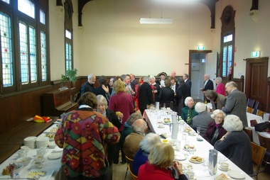
 St Kilda Historical Society
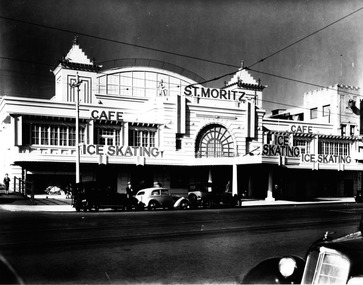
Photograph, St Moritz St Kilda - images collection #1, c1940s
... a demolition permit already issued. The building infamously suffered... a demolition permit already issued. The building infamously suffered ...The St. Moritz Ice Rink was a popular ice skating rink on The Esplanade, St. Kilda, Victoria. It operated between 1939–1981. As one of only two ice rinks in Melbourne in the 1940s and 1950s, it played a central role to the sport of ice hockey in Australia. Closed in 1982, it soon suffered a major fire and was then demolished, an event later seen as a major blow to the heritage of St Kilda. It was first built as the Wattle Path Palais de Danse in 1922, a very large dance hall, designed by architects Beaver & Purnell, The Wattle Path was the venue for the first all-Australian dance championship, and featured some of the best dance bands of Australia, as well as from America. Popular throughout the 1920s, it suffered due to the Great Depression, and closed in the early 1930s. From 1933-1936 the building became a film studio, Efftee Studios, for Frank W. Thring. In 1938, businessman Henry Hans "Harry" Kleiner announced that the Wattle Path would become an ice rink. He was sole proprietor until 1953, when he sold the business to J. Gordon and T. Molony, both champion skaters. Trade declined during the 1970s. The building was sold in 1980 to developers Hudson Conway and trucking magnate Lindsay Fox and was closed in early 1982. It was nominated to the Historic Buildings Preservation Council, but a majority of City of St Kilda councillors voted to oppose this action and uphold a demolition permit already issued. The building infamously suffered a fire later that year, leaving only the facades, which were demolished soon after. The site remained vacant until about 1991, when a mid-price hotel called the St Moritz was constructed. By 1993 it was simply called the Novotel St Kilda. The hotel closed in 2019 and was replaced by an apartment complex.black and white photographSt Moritz, St Kilda. Ice Skating. Caf�st moritz, st kilda, the esplanade, ice skating -
 Tatura Irrigation & Wartime Camps Museum
Sketch, 1943
Josef Thum was a Austrian artist in Camp 13, as a POW. Ken Hill was a member of AAAS - Mobile Cinema Unit 36 around 1946-47 and based at Murchison. After hostilities ceased, Thum was permitted to assist Ken Hill in the presentation of "pictures" as was the common term of the period, each time there was a screening at MurchisonBlack and white pencil sketch of a bridge, Church Spire and building in Melbourne. Dated 17.8.43. A piece of tissue paper is attached to cover the sketch."melbourne", sketch, thum j, hill k, aaas, camp 13, tatura, illustrations, pencil -
 Sunshine and District Historical Society Incorporated
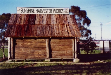
Replica of McKay Smithy, Opened on 10 October 2001
This Smithy is a replica of the building in which the first H. V. McKay harvester was built at Drummartin in northern Victoria in 1884. The original Smithy was moved from Drummartin to Sunshine Victoria where it remained for many years outside the H. V. McKay manufacturing plant. With the construction of the standard gauge railway line the road outside the Smithy was demolished, and the original Smithy was taken to the Melbourne Museum.The original Smithy is now in a fragile state and is no longer on public display at the Melbourne Museum. The site where the original Smithy stood in Sunshine was no longer available so the replica Smithy was erected a few hundred metres away, in the South East corner of Barclay Reserve on King Edward Ave, Albion 3020.The replica Smithy permits the public to view a full sized model of the building which eventually led to the formation of the H. V. McKay Sunshine Harvester Works. This firm grew to being considered the main manufacturing plant in the southern hemisphere, and also led to the local area being renamed in 1907 from Braybrook Junction to Sunshine.Brown wooden building with bark roof. This building is a FULL SIZED REPLICA of the original SMITHY that was used by H. V. McKay.THE SUNSHINE HARVESTER WORKS 1884smithy, h. v. mckay, sunshine harvester works, drummartin, replica, massey harris, massey ferguson -
 Stawell Historical Society Inc
Photograph, Armstrong’s Area Houses c 1990's -- 2 Photos -- Coloured
Residence Fountainhead Brewery Armstrong's Est. c 1872. The rear view photograph shows a more recent renovated building. Some evidence of demolition to rear of building (servants stairs etc.) Following notes taken from information in album 9 - "Compare earlier photos and note balcony etc. Later views, This photo early 2003. Owing to timber decay balcony was removed for safety. Finances permitting complete balcony will be replaced. Twin columns and iron lace are not original. Early description mentions statues in "niches" beside door. Female statue left is original. White pedestal at left was male stature damaged by a falling tree. Both statues were fountains." Photographs taken by Mr. Don Richard and held in Album 9b Armstrong’s Area.Two coloured photographs, of a brick double story building. The front view of the building has 4 windows and 2 doors. Two white columns at the entrance with decorative iron work support the roof of the porch with 2 white chairs and a table on top. Either side of the entrance door are 2 white wall indents "niches" with pot plants. The second photo show the back view of the two story building with a single story building attached that has a tin roof. A timber fence with a gate shows the side entrance to the single story building. 648M NHNN 8H01HPRO3 WIMMERA 1MHGINGstawell -
Koorie Heritage Trust
Book, Beveridge, Peter, The Aborigines of Victoria and Riverina, 1889
The author arrived in Victoria at the age of 10 years in 1839. His family gave their name to the Victorian town. He and his brother settled at 'Tyntynder' outside Swan Hill in 1845. His brother was killed by Aborigines. Brought into daily contact with the Aborigines of the area he gradually acquired their language and was permitted to learn much denied to other whites. By 1883 he had amassed a large amount of information which he put into the form of a Paper, read before the Royal Society of New South Wales. This paper may be regarded as the skeleton of the volume now publishjed. Victoria -- Riverina Aboriginals, Victoria -Swan Hill region. Lifestyle; customs and beliefs. Tyntynder(Vic) Aboriginals - Murray River tribes; language; magic; religion and practices.191p.; vocab. list; The author arrived in Victoria at the age of 10 years in 1839. His family gave their name to the Victorian town. He and his brother settled at 'Tyntynder' outside Swan Hill in 1845. His brother was killed by Aborigines. Brought into daily contact with the Aborigines of the area he gradually acquired their language and was permitted to learn much denied to other whites. By 1883 he had amassed a large amount of information which he put into the form of a Paper, read before the Royal Society of New South Wales. This paper may be regarded as the skeleton of the volume now publishjed. Victoria -- Riverina Aboriginals, Victoria -Swan Hill region. Lifestyle; customs and beliefs. Tyntynder(Vic) Aboriginals - Murray River tribes; language; magic; religion and practices.aboriginal australians -- victoria. | aboriginal australians -- murray river valley (n.s.w.-s.a.) -
Koorie Heritage Trust
Book, Bannister, S, British colonization and coloured tribes, 1838
the whole aborigines subject must soon be taken up by the best statesmen in this country. National efforts alone will turn mischievous squatters into useful settlers, and lead aright the tens of thousands at this moment bursting through every frontier we occupy in Canada, in South Africa, and in all the Australias. without national effforts to correct present oppression, buccaneering in every remote sea must spring out of the indulgence now permitted with impunity to the violent passions of uncontrolled men; and witout national effforts now put forth, to follow up and crown those of the admirable missionaries, the possession of unwatched power will corrupt even them; and the whole work, now calling for your aid, must be done hereafter with lessened means of success and infinitely increased obstacles.p.323; appendices; 19 cm.the whole aborigines subject must soon be taken up by the best statesmen in this country. National efforts alone will turn mischievous squatters into useful settlers, and lead aright the tens of thousands at this moment bursting through every frontier we occupy in Canada, in South Africa, and in all the Australias. without national effforts to correct present oppression, buccaneering in every remote sea must spring out of the indulgence now permitted with impunity to the violent passions of uncontrolled men; and witout national effforts now put forth, to follow up and crown those of the admirable missionaries, the possession of unwatched power will corrupt even them; and the whole work, now calling for your aid, must be done hereafter with lessened means of success and infinitely increased obstacles.colonization. | indigenous peoples. | indigenous peoples -- british colonies. -
Whitehorse Historical Society Inc.
Document, Whitehorse heritage review, 2002
Whitehorse heritage place list Nov 2000, with overlay [permit] guidelines.Whitehorse heritage place list Nov 2000, with overlay [permit] guidelines.Whitehorse heritage place list Nov 2000, with overlay [permit] guidelines.city of whitehorse, historic buildings, houses, heritage studies -
Whitehorse Historical Society Inc.
Newspaper - Article, Permit for units, 15/09/1992
Nunawading's Council will allow the building of 3 units on the land of Nunawading's oldest resident's previous home of Miss Kit St Clai. Vernal Avenue residents have vigorously opposed the application.houses, vernal avenue, mitcham, st. clair, catherine, mckittrick, david, athan, savvas, plummer, jan, cooper, les -
 Ballarat Heritage Services
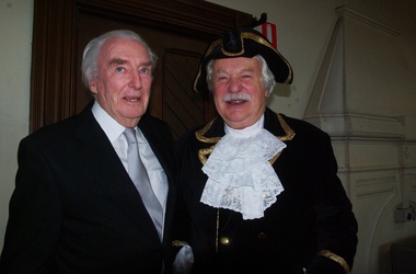
Digital photographs, L.J. Gervasoni, Prof McIntyre and Philip Slobom, c2009
Environmental approach to preserving Kew Court House 4 June 2010 Paint stripping from older buildings can be a hazardous task. The City of Boroondara has found an environmentally sustainable solution for the works at local heritage icon, the Kew Police Station and Court House. Council used an organic based paint stripping alternative as part of the repairs to the rendering on the building facade. Over nearly three months, the damaged and unsound render was removed, the paint was stripped and the render was repainted. Usually, paint is removed via high pressure water cleaning or sandblasting. This is a harsh method and involves combining extreme high amounts of pressure, water and sand and is highly toxic. It also creates high noise levels. In this 'green' project, Council used a soy bean paint stripper. The process uses a paste-like substance, which is highly effective, non toxic and biodegradable, and applied by hand. Initially, a bandage is applied (much like a leg waxing strip) over the top of paste. It is allowed to dry and then the bandage is stripped off. Noise was kept to a minimum by using the paint stripping alternative. Scrapings and bandages are then bagged and sent to the tip as landfill, so it does not end up in our water supply. The waste and debris don’t run-off into drains, and the bags and bi-products are biodegradable. Studley Ward Councillor Phillip Healey explained that soy bean paint removal is not greatly used in Melbourne or the local government sector. "We know of special cases where it has been used, such as high profile projects like Sydney Harbour Bridge, but Boroondara is one of the first in Victoria to employ this natural plant-based paint-stripping treatment to a large-scale building," Cr Healey said. "What this means is that no harmful substances were used and no injury was caused, soy paint removal also preserves, protects and restores the heritage integrity and decorative stone masonry features of the historic building. "This is a terrific example of our commitment to 'enhancing the environment' which is one of our key directions in the 2010–15 Council Plan." The restoration of the Kew Court House and Police Station is expected to be completed in the year ahead. Council purchased the heritage building in 2007 with the intention for it to be restored and used for the community. The building required extensive renovation including repair of the slate roof and ventilation dome, and the renovation plans include a new foyer, bathrooms and kitchen to ensure the venue meets a broad range of community needs. Heritage Victoria helped fund the cost of the roof repairs with a grant of $250,000, along with the Australian Government contributing $330,000 through its Regional and Local Community Infrastructure Program. Restoration Underway Concept plans for a new performance and exhibition space at the Kew Court House and Police Station have been developed by the City of Boroondara. Two years ago, Council Purchased the Kew Court House and Police Station from the State Government for $825,000 with the intention for it to be restored and used for the community. The building requires extensive renovation including repair of the slate roof and ventilation dome. The renovation plans include a new foyer, bathrooms and kitchen to ensure the venue meets a broad range of community needs. The restoration has been assisted with a Federal Government grant of $330,000 under the Regional and Local Community Infrastructure Program. In 2008, Council was also successful in obtaining a Heritage Victoria Grant of $250,000 towards the costs of the roof repairs. Having satisfied the necessary permit requirements, works are about to commence using slate of a similar quality to the original. The City of Boroondara would like to thank all residents and businesses who have contributed to the Kew Court House Restoration Appeal which has raised $650,000. Special thanks go to a private donor who donated $250,000 and the Kew Senior Citizens Club which contributed $50,000. NEWS FLASH 14th March “Council moves to provide certainty for the restoration of the courthouse”. In a historic meeting last night 13th March 07 at Boroondara Council voted overwhelmingly to complete the purchase of the Kew Court House. The partnership continues between the Kew Court House Restoration Appeal and the Council to see this project through. The project now has the overwhelming support of Council. “It is no longer about “if” it is about “when” the doors will re open” said Prof Peter McIntyre. With the property secured the fundraising can now be completed without the encumbrances and we know the restoration will be undertaken as the funds become available from the appeal. Work can commence as soon as significant fund raising is achieved. “The community, philanthropists and corporations can now enter this project with certainty. 7th March At the Council meeting on 5th March, following many hours of debate a motion was passed by 5 to 4 vote to purchase the Kew Court House and Police Station outright. As of 7th March Cr Dick Menting lodged a rescission notice. This means that there was another Council meeting at 6pm, Tuesday 13th March at Council Chambers. MEDIA RELEASE - Kew, 3rd December 2006 APPEAL LAUNCHED TO SAVE A NATIONAL TREASURE On the morning of Saturday 18th. November 2006 the people of Kew were aroused by the triumphant sound of the Boroondara Brass which had assembled outside the former Kew Police Station. After four long years of neglect, the precinct was being heralded back to life, and what a heartwarming sound it was for all those early shoppers who gathered to hear Cr. Phillip Healey introduce Patrons and supporters of the Save the Court House campaign. Following the speeches, the "Thermometer" was unveiled and the Appeal was formally under way. The various committees have worked very hard during these past weeks. The Kew Court House Arts Association Inc. has been formed under the leadership of Graeme McCoubrie. This organization brings all the amateur theatre groups in the City of Boroondara together with a view to providing them with a permanent performing space within the former Court House. As well as intimate theatre, there will be provision for the staging of instrumental and choral performances before an audience of 40 to 50 people. The Police Station will compliment the function of the Court House by providing a venue for artist groups to exhibit their work, for the Historical Societies of Boroondara to meet, and for study groups to meet, for activities such as play and poetry readings. It will be a Hub for the Arts in Kew. Of course none of this can happen unless the money to pay for restoration of the buildings is raised, and we only have until March 2007 in which to do this. The City of Boroondara, Kew Historical Society and the East Kew Community Bank are working together as a team to make this dream a reality, but WE NEED YOUR HELP. This is a fantastic one-off opportunity, and it must not be wasted. Donations to the Appeal can be made through the Kew East Kew Community Bank or any branch of the Bendigo Bank, or through the Kew Historical Society Inc., P.O. Box 175 Kew Vic 3101. All donations over $2 are tax deductible through the Community Enterprise Foundation. End Media Release Kew Courthouse future looks bright The State Government has accepted an offer from the local government of Boroondara to purchase the former Kew Courthouse and Police Station, Minister for Finance John Lenders said today. In a joint statement with the Mayor of Boroondara, Councillor Jack Wegman, Mr Lenders said he was pleased that agreement had been reached and the contract of sale document finalised. “I welcome the Council making this step towards purchasing this property after recent negotiations,” Mr Lenders said. “The settlement date for the purchase of the property is March 2007. The State government sold the property to Council at a reduced cost of $825,000 for community use. The full value of the buildings on the commercial marketplace was estimated to be about $2million,” he said. Cr Wegman said the Contract of Sale provides that if the funds cannot be raised to restore the property for use as community buildings then they will be returned to the State government. In relation to this additional funding to restore and modernise the buildings, Council and the community will work together over the next eight months, with the encouragement of the State government, Cr Wegman said. Mr Lenders said both he and the Premier had advised the Council of fundraising opportunities to help the Council convert the property for its future use. Cr Wegman noted that applications for funding from the Community Support Fund and for State government heritage grants were being processed. “Council has agreed to a Memorandum of Understanding with the Kew Historical Society outlining arrangements for the Kew Court House Restoration Appeal and Council is delighted with the level of support shown by the community and is confident of a bright future for these historic buildings.” Mr Lenders said the Bracks Government is committed to securing the best outcome when buildings that have once served the community outlive their original purpose. “There is a responsibility for Governments to practice good financial management and achieve the best possible price when an asset is longer used by the State,” he said. “There is also a responsibility to consider the local community. The Government and City of Boroondara have worked hard to achieve a balance between these two interests.” The building ceased to operate as a courthouse in 1971 and as a police station in 2002. Part of the building was also used as a post office and this section of the building was sold by the Commonwealth in 1992 to a private owner and is currently run as a licensed restaurant. It is listed on the State's Heritage Register as a place of historical and architectural significance and is protected by the Victorian Heritage Act. Created: 30 August 2006 Last Update: 10 January 2007 kew, kew court house, phillip slobom, town crier, professor peter mcintyre -
 Ballarat Heritage Services
Photograph - Digital photographs, L.J. Gervasoni, Kew Historical Society in the Former Kew Court House, c2009
Environmental approach to preserving Kew Court House 4 June 2010 Paint stripping from older buildings can be a hazardous task. The City of Boroondara has found an environmentally sustainable solution for the works at local heritage icon, the Kew Police Station and Court House. Council used an organic based paint stripping alternative as part of the repairs to the rendering on the building facade. Over nearly three months, the damaged and unsound render was removed, the paint was stripped and the render was repainted. Usually, paint is removed via high pressure water cleaning or sandblasting. This is a harsh method and involves combining extreme high amounts of pressure, water and sand and is highly toxic. It also creates high noise levels. In this 'green' project, Council used a soy bean paint stripper. The process uses a paste-like substance, which is highly effective, non toxic and biodegradable, and applied by hand. Initially, a bandage is applied (much like a leg waxing strip) over the top of paste. It is allowed to dry and then the bandage is stripped off. Noise was kept to a minimum by using the paint stripping alternative. Scrapings and bandages are then bagged and sent to the tip as landfill, so it does not end up in our water supply. The waste and debris don’t run-off into drains, and the bags and bi-products are biodegradable. Studley Ward Councillor Phillip Healey explained that soy bean paint removal is not greatly used in Melbourne or the local government sector. "We know of special cases where it has been used, such as high profile projects like Sydney Harbour Bridge, but Boroondara is one of the first in Victoria to employ this natural plant-based paint-stripping treatment to a large-scale building," Cr Healey said. "What this means is that no harmful substances were used and no injury was caused, soy paint removal also preserves, protects and restores the heritage integrity and decorative stone masonry features of the historic building. "This is a terrific example of our commitment to 'enhancing the environment' which is one of our key directions in the 2010–15 Council Plan." The restoration of the Kew Court House and Police Station is expected to be completed in the year ahead. Council purchased the heritage building in 2007 with the intention for it to be restored and used for the community. The building required extensive renovation including repair of the slate roof and ventilation dome, and the renovation plans include a new foyer, bathrooms and kitchen to ensure the venue meets a broad range of community needs. Heritage Victoria helped fund the cost of the roof repairs with a grant of $250,000, along with the Australian Government contributing $330,000 through its Regional and Local Community Infrastructure Program. Restoration Underway Concept plans for a new performance and exhibition space at the Kew Court House and Police Station have been developed by the City of Boroondara. Two years ago, Council Purchased the Kew Court House and Police Station from the State Government for $825,000 with the intention for it to be restored and used for the community. The building requires extensive renovation including repair of the slate roof and ventilation dome. The renovation plans include a new foyer, bathrooms and kitchen to ensure the venue meets a broad range of community needs. The restoration has been assisted with a Federal Government grant of $330,000 under the Regional and Local Community Infrastructure Program. In 2008, Council was also successful in obtaining a Heritage Victoria Grant of $250,000 towards the costs of the roof repairs. Having satisfied the necessary permit requirements, works are about to commence using slate of a similar quality to the original. The City of Boroondara would like to thank all residents and businesses who have contributed to the Kew Court House Restoration Appeal which has raised $650,000. Special thanks go to a private donor who donated $250,000 and the Kew Senior Citizens Club which contributed $50,000. NEWS FLASH 14th March “Council moves to provide certainty for the restoration of the courthouse”. In a historic meeting last night 13th March 07 at Boroondara Council voted overwhelmingly to complete the purchase of the Kew Court House. The partnership continues between the Kew Court House Restoration Appeal and the Council to see this project through. The project now has the overwhelming support of Council. “It is no longer about “if” it is about “when” the doors will re open” said Prof Peter McIntyre. With the property secured the fundraising can now be completed without the encumbrances and we know the restoration will be undertaken as the funds become available from the appeal. Work can commence as soon as significant fund raising is achieved. “The community, philanthropists and corporations can now enter this project with certainty. 7th March At the Council meeting on 5th March, following many hours of debate a motion was passed by 5 to 4 vote to purchase the Kew Court House and Police Station outright. As of 7th March Cr Dick Menting lodged a rescission notice. This means that there was another Council meeting at 6pm, Tuesday 13th March at Council Chambers. MEDIA RELEASE - Kew, 3rd December 2006 APPEAL LAUNCHED TO SAVE A NATIONAL TREASURE On the morning of Saturday 18th. November 2006 the people of Kew were aroused by the triumphant sound of the Boroondara Brass which had assembled outside the former Kew Police Station. After four long years of neglect, the precinct was being heralded back to life, and what a heartwarming sound it was for all those early shoppers who gathered to hear Cr. Phillip Healey introduce Patrons and supporters of the Save the Court House campaign. Following the speeches, the "Thermometer" was unveiled and the Appeal was formally under way. The various committees have worked very hard during these past weeks. The Kew Court House Arts Association Inc. has been formed under the leadership of Graeme McCoubrie. This organization brings all the amateur theatre groups in the City of Boroondara together with a view to providing them with a permanent performing space within the former Court House. As well as intimate theatre, there will be provision for the staging of instrumental and choral performances before an audience of 40 to 50 people. The Police Station will compliment the function of the Court House by providing a venue for artist groups to exhibit their work, for the Historical Societies of Boroondara to meet, and for study groups to meet, for activities such as play and poetry readings. It will be a Hub for the Arts in Kew. Of course none of this can happen unless the money to pay for restoration of the buildings is raised, and we only have until March 2007 in which to do this. The City of Boroondara, Kew Historical Society and the East Kew Community Bank are working together as a team to make this dream a reality, but WE NEED YOUR HELP. This is a fantastic one-off opportunity, and it must not be wasted. Donations to the Appeal can be made through the Kew East Kew Community Bank or any branch of the Bendigo Bank, or through the Kew Historical Society Inc., P.O. Box 175 Kew Vic 3101. All donations over $2 are tax deductible through the Community Enterprise Foundation. End Media Release Kew Courthouse future looks bright The State Government has accepted an offer from the local government of Boroondara to purchase the former Kew Courthouse and Police Station, Minister for Finance John Lenders said today. In a joint statement with the Mayor of Boroondara, Councillor Jack Wegman, Mr Lenders said he was pleased that agreement had been reached and the contract of sale document finalised. “I welcome the Council making this step towards purchasing this property after recent negotiations,” Mr Lenders said. “The settlement date for the purchase of the property is March 2007. The State government sold the property to Council at a reduced cost of $825,000 for community use. The full value of the buildings on the commercial marketplace was estimated to be about $2million,” he said. Cr Wegman said the Contract of Sale provides that if the funds cannot be raised to restore the property for use as community buildings then they will be returned to the State government. In relation to this additional funding to restore and modernise the buildings, Council and the community will work together over the next eight months, with the encouragement of the State government, Cr Wegman said. Mr Lenders said both he and the Premier had advised the Council of fundraising opportunities to help the Council convert the property for its future use. Cr Wegman noted that applications for funding from the Community Support Fund and for State government heritage grants were being processed. “Council has agreed to a Memorandum of Understanding with the Kew Historical Society outlining arrangements for the Kew Court House Restoration Appeal and Council is delighted with the level of support shown by the community and is confident of a bright future for these historic buildings.” Mr Lenders said the Bracks Government is committed to securing the best outcome when buildings that have once served the community outlive their original purpose. “There is a responsibility for Governments to practice good financial management and achieve the best possible price when an asset is longer used by the State,” he said. “There is also a responsibility to consider the local community. The Government and City of Boroondara have worked hard to achieve a balance between these two interests.” The building ceased to operate as a courthouse in 1971 and as a police station in 2002. Part of the building was also used as a post office and this section of the building was sold by the Commonwealth in 1992 to a private owner and is currently run as a licensed restaurant. It is listed on the State's Heritage Register as a place of historical and architectural significance and is protected by the Victorian Heritage Act. Created: 30 August 2006 Last Update: 10 January 2007 Colour photograph of the Kew Historical Society holding an event in the Former Kew Court House.kew, kew court house, kew historical society, meeting, city of boroondara -
 Whitehorse Historical Society Inc.
Photograph, Colombo Street, Mitcham, 2006
Development of fourteen story apartment block. Given a permit in 2004. Permit not extended on 2007.Coloured photo of land for proposed development of a fourteen storey apartment block in Colombo Street, Mitcham (previously site of Brewer Sporting Goods Manufacturing Goods Factory)colombo street mitcham, high-rise buildings -
 Ballarat Heritage Services
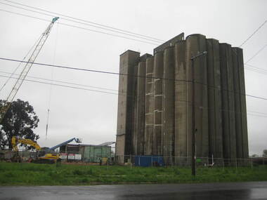
Photograph - Photograph - Colour, Lisa Gervasoni, Joe White Maltings Silos Under Demolition, 2010, 15/10/2010
"A plan to turn the Gregory Street silos into apartments is no more.Developers Eleveno Pty Ltd have abandoned plans to transform the Lake Wendouree silos into a giant apartment complex, despite previously being given the green light from the Victorian Civil and Administrative Tribunal.Director Richard Sykes yesterday confirmed the silos would be demolished."The plans are not proceeding. The plan now is to create residential houses," he said.The planning permit for an 18-lot subdivision was approved by Ballarat City Council on July 22, despite objections lodged against the application.Mr Sykes said it wasn't feasible to turn the silos into 27 units and there were many factors behind the decision."They're being demolished for various reasons, there were just better solutions," he said.Bold plans to transform the former Joe White Maltings silos into apartments were first submitted to Ballarat City Council in January 2007.However, developers took the proposal to VCAT in September 2008 after council failed to make a decision in the required 60-day timeframe.A hearing was held in early 2009 and the development was approved in March last year.Mr Sykes said it was found that the building would most likely be out of place in the region."We found the market didn't really want that sort of development," he said."They're probably more suited for inner-city development, rather than regional areas."Mr Sykes did not put a price on either the proposed development or the demolition, but said it would "cost a fair amount of money".He said once the demolition permit has been passed, works were expected to begin in November." (Ballarat Courier, 03 August 2010)Joe White Maltings Silos in Gregory Street Ballarat under demolition, to make way for a housing development. The silos were built on the banks of Lake Wendouree. joe white maltings, silo, eleveno pty ltd, lake wendouree, demolition, gregory street ballarat, wendouree parade, architecture -
 International House, The University of Melbourne
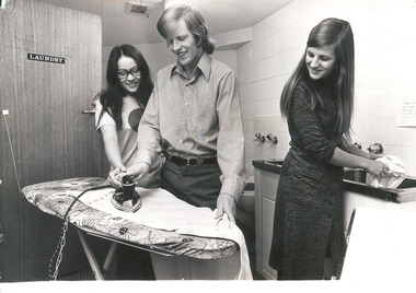
Photograph (Item), Students Felicity Ho and John Howie ironing, and Megan Edwards washing clothes in a Scheps Building laundry, 1972
This image brings together two major events in International House history in 1972, the opening of the Scheps Wing, and the admittance of women. Female students were initially accommodated on separate floors, and the Council has since attempted to maintain between 25% and 50% female students. The Scheps Wing was opened in May that year, named in honour of donors Theodor and Ida Scheps, its 92 rooms accomodating the growth of IH's diverse student body. John Howie was IH Student Club President from 1971-1972, the first permitted to regularly attend IH Council Meetings after years of petitioning for Council representation by the Student Club. Felicity Ho and John Howie, pictured ironing together here, later married."Photographed for publicity" inscribed in pen on reverse with names of subjects and datelaundry, scheps wing, students -
 Southern Sherbrooke Historical Society Inc.
Information folder - Madigan Cottage
The buildings are probably rare remnant examples of their type in the local area and as such are significant to the settlement of Menzies Creek. The dwelling is significant as a longstanding marker of the Madigan family who were original settlers in the area. Its retention in its site close to the road boundary expresses and maintains a connection with early settlement and rural lifestyles in Menzies Creek over the last century. The old shed is of interest as a local example of bush construction, particularly in context with the cottage and farm environs. Without the life of the farm and other elements presumed now gone, its value is lessened.Folder containing information pertaining to the history of Madigan Cottage, Menzies Creek. NB: the shed was demolished in November 2001 and the cottage burned down sometime later. Contents:- Letter, Southern Sherbrooke Historical Society to Shire of Yarra Ranges, dated 9th March 2001, re. sale of property and need for it to be included in shire's Heritage Study. -Letter, shire to society, dated 20th March 2001, reply to above. -Letter, shire to society, dated 15th May 2001, follow-up to above, requesting more information. -Letter, society to shire, dated 30th May 2001, responding to above and including a copy of information previously sent to Chris Johnston, Heritage Study consultant. -Letter, society to shire, undated, noting intention to lodge an objection to proposed application for development on site. -Letter, shire to society, dated 22nd October 2001, advising of consultation meeting. -Yarra Ranges Shire Heritage Study Place Nomination form for Madigan Cottage, prepared by Marian Matta, includes nine colour photos and diagram showing where photos were taken from. -Black and white copies of photos. -A3 copy of real estate advertisement, "Mount Evergreen Estate" dated 21st April 1924. -A3 map showing proposed resubdivision boundary variation, drawn up for Mr. P. Melville, undated but 1990s. -Copy of application for a planning permit, dated 6th August 2001, including letter by Nick Jonkers describing proposed new buildings, site map showing current vegetation, letter re. proposed removal of vegetation, subdivision plan dated March 1998, and larger scale map printed from shire website on 10th August 2001. -5 A3 sheets showing site and house plans drawn up for Mr & Mrs N. Jonkers, dated July 2001.madigan cottage, menzies creek, madigan family, mount evergreen, patrick madigan -
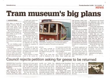 Ballarat Tramway Museum
Newspaper, The Courier Ballarat, "Tram Museum's big plans", Dec. 2019
Set of 7 items related to the proposed extension of the BTM's depot to the south, Dec. 2019. Comprises: .1 - Newspaper clipping from The Courier, 19/12/2019 titled "Tram Museum's big plans", advising that the proposal was being advertised by Heritage Victoria, along with a photo of No. 26. .2 - Newspaper clipping from The Courier, 18/12/2019 for the advertising the permit application under the Heritage Act 2017 - in the Public Notice section. .3 - Digital image of "Museum Extension - Heritage Impact Statement - revised Oct. 2019." - 16 A4 pages. .4 - Digital image of Plans - 8 sheets of the proposal by MKM constructions. .5 - Digital image of Report - Urber Arbor - Arboricultural Report - Tree Management Plan. .6 - Digital image of Coloured site plan and drawings showing proposal depot trackwork and support mechanism around trees. Note this does not open on dbTextWorks interface. .7 - Digital image of 11 sheets of concept plans for the exterior and interior of the museum proposal by MKM Constructions. .8 - digital image of the advertising sign on the rear wall of the depot taken 7-1-2019. A similar poster was on the south east corner of the depot.btm, museum, drawings, depot extensions, heritage buildings, heritage, trackwork -
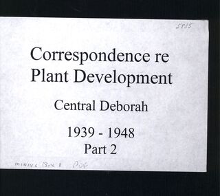 Bendigo Historical Society Inc.
Book - CENTRAL DEBORAH MINE CORRESPONDENCE RE PLANT DEVELOPMENT PART 2
Black folder containing photocopied documents pertaining to the setting up and running of the Central Deborah Mine, Bendigo. 1939 - 1948. Original copies held in McColl,Rankin & Stanistreet Collection. Application for Permit. Ministry of Post War Reconstruction. War Organisation of Industry. Quotes, Tenders. Hume & Iser. T.J Jorgensen. Electricity Supply Department. Saunders & Ross. District Telephone Office. R Toma. Stock Exchange. Building Site Plan. Abbott Supply Co. F.W. Milne & Son. The Golden City Agricultural Implements. Department of Labour and National Service.Miller & Co. Thompson Engineering and Pipe Co. Gold Boring and Prospecting. Costs. J.l. Howard. A.J. William Electrical Instruments.bendigo, mining, central deborah gold mine -
Kew Historical Society Inc
Journal, Kewriosity : June 1984
Mayoral Comment - Swedish hero honoured in Kew [Raoul Wallenberg] / Cr Jill O'Brien p1. The village without a name [Edgevale Road] / Barbara Giles p1. Billabong Club / p2. Wine bottling / p2. Sunday afternoon at Kew / p2. Kew Garden Club / p2. Native Plant Group / p2. Asian Evangelical Fellowship / p2. Early Planning for retirement / p2. The Rheumatism and Arthritis Association of Victoria / p2. Kew (Daytime) Garden Club / p2. Hyde Park Fellowship / p2. Penguin Club / p2. F.A.C.S. [Family and Community Services Programme / p3. New Residents Kits / p3. Parking permits for people with physical disabilities / p3. Occupational Therapist in Kew / p4. Physiotherapists / p4. Speech pathology / p4. Children's Services / p4. Area 10 Traffic Management / p5. Kew Historical Society happenings / p5. Community artists / p5. New Victoria building regulations / p6. Voting / p6. Safety [footpaths] / p6. Domestic noise / p6. Volunteers ["Gatehouse"]/ p7. Foster Care information [Inner East Foster Care] / p7. Kew Residents Group / p7. Black sheep and family crests [Kew Library, Genealogy] / p7. Infantile Paralysis [Poliomyelitis] / p7. Kew Community House News / Rhonda McCaw p8. Art Show / p8. Immunisation Sessions / p8. Parks and gardens / p8.Kewriosity was a local newsletter combining Kew Council and community news. It was published between November 1983 and June 1994, replacing an earlier Kewriosity [broad] Sheet (1979-84). In producing Kewriosity, Council aimed to provide a range of interesting and informative articles covering its deliberations and decision making, together with items of general interest and importance to the Kew community and information not generally available through daily media outlets.non-fictionMayoral Comment - Swedish hero honoured in Kew [Raoul Wallenberg] / Cr Jill O'Brien p1. The village without a name [Edgevale Road] / Barbara Giles p1. Billabong Club / p2. Wine bottling / p2. Sunday afternoon at Kew / p2. Kew Garden Club / p2. Native Plant Group / p2. Asian Evangelical Fellowship / p2. Early Planning for retirement / p2. The Rheumatism and Arthritis Association of Victoria / p2. Kew (Daytime) Garden Club / p2. Hyde Park Fellowship / p2. Penguin Club / p2. F.A.C.S. [Family and Community Services Programme / p3. New Residents Kits / p3. Parking permits for people with physical disabilities / p3. Occupational Therapist in Kew / p4. Physiotherapists / p4. Speech pathology / p4. Children's Services / p4. Area 10 Traffic Management / p5. Kew Historical Society happenings / p5. Community artists / p5. New Victoria building regulations / p6. Voting / p6. Safety [footpaths] / p6. Domestic noise / p6. Volunteers ["Gatehouse"]/ p7. Foster Care information [Inner East Foster Care] / p7. Kew Residents Group / p7. Black sheep and family crests [Kew Library, Genealogy] / p7. Infantile Paralysis [Poliomyelitis] / p7. Kew Community House News / Rhonda McCaw p8. Art Show / p8. Immunisation Sessions / p8. Parks and gardens / p8. publications -- city of kew (vic.), kewriosity, council newsletters, community newsletters -
 Friends of Westgarthtown
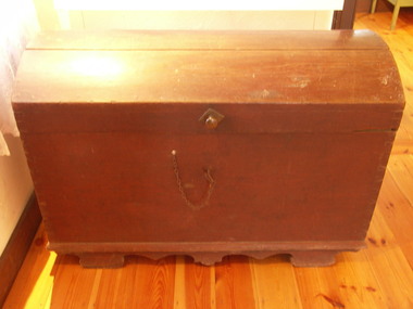
Trunk/ Koffer, c. 1840s
The chest was constructed to allowable dimensions for storage in the ship's hold. The sturdy watertight construction afforded protection for the chests contents. It can be imagined that these would be household utensils, items of clothing and the most treasured ornaments as space permitted. It is likely that the contents included some building tools and as well, implements which Christian Ziebell used in his trade as a butcher in Bruel, thereby enabling him to undertake profitable work on his arrival in Australia.This object is of primary significance. The Koffer was constructed to allowable dimensions for storage in the ship’s hold. The sturdy watertight construction afforded protection for the Koffer’s contents on the voyage aboard the Privislaw from Hamburg, Germany to Hobsons Bay, Australia in 1850. The Koffer held the precious necessities for life for Christian Ziebell's family at their new destination. It is likely that the contents included some building tools as well, implements that Christian used in his trade as a butcher in Bruel, thereby enabling him to undertake profitable work on arrival in Australia. The wooden Koffer was airtight, so if lost overboard it would be retrievable. Some were fixed to the ship’s deck. After they settled at Westgarthtown the Koffer continued to contain the precious documents through each generation. Only the current owners saw the contents in each generation, and the children always regarded it as a “treasure chest”, which was always locked and out of bounds for them. Large wooden trunk/koffer. Base is rectangular, and lid is rectancular to fit the base but curves between the front and back. Morticed corners; protruding base with beveled edge. Supported by profiled runners with four built-in feet. Handle for carrying on each end, and locking mechanism on front.'C. Ziebell' written in large font on back of chestpersonal effects, travel goods, pribislaw, johann christian ziebell, german migration, luggage -
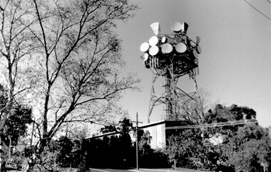 Surrey Hills Historical Society Collection
Photo, Telecom tower, Canterbury Road
This photo of the Telecom Tower was one of a series of photos taken of landmarks and houses of the area by Ken Hall in c1980. The PMG / Telecom / Telstra tower was built in 1961-1963 as a relay station to support television and radio links between city and regional broadcasting stations. The tower itself was 45 m in height with a 2 storey building for equipment and staff surrounded by garden. From the beginning it was opposed by local residents. In response to a Telstra application to replace it with a 40m slimline monopole, the City of Whitehorse controversially sought to have the structure heritage-listed, a move which caused much debate. In May 2015 Council ultimately rescinded its decision and gave permission for demolition, however Telstra deemed the permit conditions to be too restrictive and decided to continue to use the tower. The permit (to replace the tower) expired in September 2017. A black and white photo of local landmark visible from many vantage points in Surrey Hills and surrounding area, as it was built on the high point of the area.telecommunications tower, city of whitehorse, heritage overlay, heritage study, development, pmg tower, telstra, telecom, harding street, canterbury road -
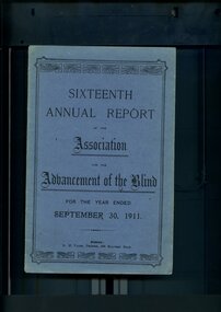 Vision Australia
Administrative record - Text, Sixteenth Annual Report of the Association for the Advancement of the Blind 1911, 1911
Annual report of the Association for the Advancement of the Blind outlined activities and events over the year, including membership of 299, 1000 visits were paid during the year, the Public Works department erected a set of steps from the top of the cliff to the sands so that Home residents may be able to access the beach, Railway Permits will now also be honoured on the Prahran-Malvern Electric Tramway and Bay Excursion Steamers, a concert party toured to Egerton, Ballan, Bacchus Marsh, Myrniong and Toolern Vale for the dual purpose of raising awareness and funds for the Association, Mr A Solomon has been appointed as a second Collector to visit Country Towns and with the support of the wife of the Minister for Public Works, Miss Aston and Miss Munce waited on the Lady Mayoress of Melbourne, gave her full support to organise a fund to purchase the land and buildings in Mair Street for the Association.1 volume of printed material with some illustrationsassociation for the advancement of the blind, annual reports -
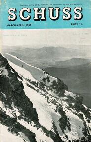 Falls Creek Historical Society
Journal - Schuss Vol. 19. No. 2 March - April 1953
Schuss was advertised as Victoria’s Official Ski Journal It was issued monthly from 1935 to 1961 except during the war when summer issues covered two months. This continued after the war, but it averaged 10 issues annually over its 25 year life. Schuss was published by the Ski Club of Victoria which had a membership of 38 Ski Clubs and demanded to be recognised as the prime authority on skiing in the state. The other 30 ski clubs with 85% of the members disagreed and the politics of skiing became heated. These clubs formed the Federation of Victorian Ski Clubs with their own journal, Ski Horizon. With the establishment of the Victorian Ski Association, Ski-Horizon published its last issue in Nov - Dec. 1955 and the role of the official journal was fully taken over by “Schuss”. This item is significant because it contains stories, images and information documenting the development of the ski industry in Victoria.The journal features stories and events chronicling developments in Victoria and internationally. Items related to the Falls Creek Area in this issue include:- Cover - Features a photo by H.Gibbs titled "Western Cliffs of Mt. Bogong" Page 65 - BOB HYMANS reported news of Falls Creek. At his own Ski School, notable improvements to accommodation have been made and additions to the building itself, which will make it very much more comfortable and serviceable to visitors. Water supply and heating are amongst the items in hand. Bob has acquired a Land Rover which will be a power of assistance to him in maintaining fresh supplies and in servicing his project generally. Kiewa Valley Ski Club members are making splendid progress with the erection of their Lodge. This is the latest building addition in that area and raises the number of clubs resident there to nine. Nissen Ski Tow members intend to operate their tow on the upper slopes of Falls Creek every day during the coming season that conditions permit. They are to be warmly commended on their enterprise. Page 65 - Advertisement for Bob Hymans' Ski School and Lodgeschuss journal, bob hymans, kiewa valley ski club, nissen tow -
 Melton City Libraries
Photograph, Wesleyan Church, Unknown
On the 16th April the foundation stone of the Wesleyan Church was laid and does not appear to have been marked. It was opened for public worship on Oct 13th 1867. Rev Ken Moore of Melbourne was the preacher, only 6 months after the commencement of building. It was constructed of bluestone with a slate roof. The interior had not been plastered, nor ceiling erected, but would be a funds permitted. Cost at opening was L350/13/6; seats and deskL40. A Tea meeting was held to celebrate the opening on the following night. Church closed in 1910. Has been used as a den for the Djerriwarrh Scout Troop.Formerly Melton Wesleyan Church on Palmerston Streetchurches, local architecture -
 Eltham District Historical Society Inc
Archive Box, Shire of Eltham War Memorial
Material relating to the Shire of Eltham War Memorial located at Garden Hill, Kangaroo Ground. Also known as The Eltham Shire War Memorial Tower, Shire of Eltham Soldiers' Memorial and Kangaroo Ground War Memorial Park. Includes photocopies, newspaper clippings, correspondence and more beginning from early history 1919-2009. Contents: Archive Box 1 Folder 1 (Publication Proofs) The Tower of Remembrance and War Memorial Park On Garden Hill at Kangaroo Ground, Victoria 1919-2010 Folder 2 (Up to 1960) 1. Binder with plastic pockets. Photocopies. Minutes of the Kangaroo Ground War Memorial Bazaar Committee, 1922-1926 EDHS Newsletter No. 123 November 1998 PRESIDENT'S REPORT ACQUISITION FROM NILLUMBIK SHIRE'S MEMORABILIA Recently found in a storage box of old Shire of Eltham items was a school size, blue lined black covered writing book. It is recognized as the minute book and cash receipt book of the period 1922-1926 when the Memorial Park Committee, who it seems were part of the Shire of Eltham Soldier's Memorial League, was requested to raise funds for building the Shire of Eltham War Memorial Tower at Kangaroo Ground. History tells us that the tower, which is currently being refurbished, was officially opened by the Governor General of Australia, Lord Stonehaven on 11.11.26. The ladies invited to the first meeting at the Shire Hall did so on 21st September 1922. The minutes book reads: Present: Mesdames Bell, Bourchier, McMahon, Gosling, Cockcroft, Wraight, E Coutie, R Rogers, A Jones, AH White, Davies, Everitt and the Misses Lacey, Harris, N Weller, Gosling, Bell and D and G J Bourchier. These people became the Kangaroo Ground Memorial Bazaar Committee along with others named at further meetings. They conditionally accepted the role of raising funds, their condition being that the Bazaar Committee be given representation on any committee empowered to deal with the memorial in proportion to the amount of money raised by the bazaar'. The Andrew Ross Museum has the original book. We at Eltham District Historical Society have two photocopies for public perusal. 2. Transcriptions of newspaper articles 1919-1920. 6 pages. 3. Photocopy of program for thanksgiving service July 6th, 1919 held at Public Hall, Panton Hill. 4. Photocopies: a. Kangaroo Ground, The Advertiser, 17 Oct 1919 (working bee) b. The Advertiser August 1920 – advertisement for coach between Eltham and KG. c. Anzac Memorial Service, The Eltham & Whittlesea Shires Advertiser & Diamond Creek Advertiser, April 14, 1922 and April 28, 1922 d. Anzac Day services. April 27, 1923 e. Photocopy Anzac Commemoration, local newspaper, May 2, 1924 f. Shire of Eltham Memorial Service, The Advertiser April 23, 1926 g. Eltham Shire War Memorial Advertiser August 13,1926 h. Eltham Shire War Memorial The Advertiser October 26, 1926 i. Eltham The Advertiser, December 17, 1926 j. Kangaroo Ground April 26, 1929 5. Photocopy. Eltham War Memorial Tower article, The Advertiser, November 19, 1926 6. Typed transcription of parts of newspaper articles for three titles, November 1926 7. Transcription. Public Notice, October 16, 1926 8. Photocopy Kangaroo Ground Armistice Day local newspaper, November 25, 1927 9. Photocopy Kangaroo Ground Armistice Day local newspaper, November 16, 1928 10. Photocopy Kangaroo Ground, local newspaper, April 26 1929 11. 3 Original Copies. One Hardback. Dedication of memorial official brochure, 1951 original but damaged 12. Photocopy with notes from G.G. relating to the land transfer/acquisition/contract via White and Gepp. Folder 3 (1961-1970) 1. Original newspaper article: Place with a view at Kangaroo Ground, The Age, May 11, 1963, p18 Folder 4 (1981-1990) 1. Newspaper article, Memorial a fire watch. Diamond Valley News, March 16, 1982, 2 original copies. 2. Newspaper article. An Obvious Monument by Russell Yeoman article with photo: Network Nov/Dec 1984, p14. Folder 5 (1991-2000) 1. Original newspaper article: “Kangaroo Ground Tower is top spot”. Thought to be from a tourist information free newspaper, Mountain Country, Summer [1993] p39. 2. Newspaper article with reference to quoins – a contrasting edging or corner stone on the façade of a stone or brick house. Age August 2000 3. Program. Service program for Remembrance Day commemoration ceremony, 1996. 4. Speech by Harry Gilham for Remembrance Day commemoration ceremony, 1996 5. Newspaper article: Remembrance, Diamond Valley News, 20 November 1996 6. Word Document. A Tower of Strength by Dean Stewart April 1997 7. Newspaper articles: Tower group needed, Diamond Valley News, September 17, 1997, p3 and advertisement “Nillumbik, Nominations for Kangaroo Ground Memorial Tower and Grounds Advisory Committee”, Diamond Valley News, September 17, 1997 8. Newspaper article: Council apology; scaling new heights, 1997 about Aboriginal Reconciliation. Probably Diamond Valley News ca 1997. 9. Photocopy / Newspaper Article: Two newspaper clippings, “Memorial with a view” 30 April 1997 and “Funds boost to restore tower to its former glory”, Diamond Valley News, 3 December 1997. 10. Newspaper article: Kangaroo Ground Tower of Remembrance Nillumbik Mail, 9th August 2000 and Research notes (July 2000) by Harry Gilham pertaining to photo in August 2000 newspaper article. 11. Photocopy. Newspaper article: New lease of life for tower (Concept plan) Nillumbik Mail, September 27, 2000 12. Photocopy: 4 pages, War Memorials of Victoria; a pictorial record, c.1994 Folder 6 (2001-2010) 1. Newspaper article: $10,000 to start refurbishment, Nillumbik Mail, Feb 21, 2001 2. Circular. KG War Memorial Advisory committee circular August 2001 3. Newspaper article: Tower group retained 4. Program for re-dedication of the Kangaroo Ground War Memorial Tower 8th November 2001 with copies of pages 65-70 of from The Tower of Remembrance and War Memorial Park 1919-2001 (see Folder 1) - Speaking notes from the day from Nillumbik Shire Mayor, Cr. Sigmund Jorgensen and Harry Gilham and Speech by John Landy, Governor of Victoria 5. 2 pages of Harry Gilham notes – Draft of ‘book’ notes ‘Thank you’ for rededication ceremony to be held Thursday, Nov 8, 2001 - list of invitations, notifications and acknowledgements. 6. Proposed running sheet. Re-dedication of KGT. November 8, 2001 7. Newspaper article (2 copies) Century of war service, DVL November 14, 2001 page 6 8. Letter. Gov. John Landy to Harry Gilham. Thank you for visit. [2001] 9. Newsletter Clipping: Governor of Victoria re-dedicates KG War memorial Tower, Nillumbik News (NSC) Christmas 2001 10. Newspaper article: War Memorial to be restored: DVL November 19, 2003 11. Newspaper article: Memorial Facelift Sept 29 2004. 12. Folder. Collection of maps and context Yarra Water proposal to build water tanks 13. Newspaper clipping. Pressure on with new tank. Re installation of water tank near site. DVL March 2, 2005 14. Folder of emails and designs from Dennis Ward re poppies and prostrate rosemary for formal garden around base of tower April 2005 15. Folder. Letters and paperwork re the Victorian Government “Community Cabinet” and invitation for community groups to speak directly with a government minister. Actual submission not included in folder. 16. Newspaper clipping. Time to remember among the poppies, Diamond Valley Leader, 9 November 2005, p1 and 17. Newspaper clipping. Lone pine company for souls. DVL 9 November 2005 18. Folder. Restoring Community War Memorials Grants Program. Application and associated paperwork 2005/2006 January 2006 19. Newspaper article. Shared views. Valley Weekly, June 21 2006 20. Newspaper article: Kangaroo Ground, Restoration on schedule, DVL October 2006? 21. Newspaper article. Towering over the terrain. The Age August 8, 2009 22. Photocopy. Nillumbik Shire Council. Policy and service report re lease of land to Victoria Police for police radio communications and re-building of radio tower. December 9, 2009 23. Schematics: A3 photocopies, Kangaroo Ground memorial Tower, front and rear view, Tom Manley, 17 Apr 2001 Folder 7 (2011 on) 1. Magazine article and cover. Cover story – The Kangaroo Ground Memorial Tower, The Genealogist, March 2010 2. Newspaper article. (2 copies) Photo and caption. Diamond Valley Leader, July 14, 2010 3. Newspaper notice: Notice of application for a planning permit to construct radio communications tower, DVL, October 10, 2012 4. Copy. Reference enquiry to National Film and Sound Archive. 10 September 2012 5. Copy letter. Quotation/estimate for Shire of Nillumbik on renovation and underpinning of old care takers cottage, KG. 30 September, 2012 6. Story. The Kangaroo Ground Tower of Remembrance by Amy Shaw. Yarrambat Primary School Year 6 History speech, 2014. 7. Program: Remembrance Day service, 11th November 2014 8. Newspaper article. Tribute to bravery DVL, November 19, 2014. 9. Minutes. MAC meeting. 2 September 2016. Folder 8 (Interpretative Signs Grant 2000-2001) 1. Folder. Various including Letters. EDHS Grant project: Kangaroo Ground Park and Tower of Remembrance interpretative signage from Parks Victoria 2000-2001. Folder 9 (Miscellaneous) 1. Folder Gilham collection. Google earth images of Tower, Extract describing history of Tower, including honour roll for WW1 and WW2, 8 pages, Extract describing history of Tower, including honour roll for WW1 and WW2, 3 pages, 2002 and 2004; Kangaroo Ground Tower; Southwell-Keely M.; WAR MEMORIALS IN AUSTRALIA; 8 pages, https://web.archive.org/web/20080722161554/http://www.skp.com.au/memorials2/pages/30054.htm) 2. Letter. Undated, unsigned re application to council to proposed work to police radio masts behind caretaker’s cottage. 3. Brochure: Heritage Nillumbik. Includes cover photo and other information about site. Published by Nillumbik Shire Council. About 2006. 4. Folder of notes and photocopies of various Certificates of Title for property 5. Inward loan documents. Two. Andrew Ross Museum inward loan for collection items from “War Memorial Tower” 2003 6. Photocopies of postcards of Soldiers War Memorial: One taken c.1926 before completion around base, on colour print on paper (enlarged) of Soldiers War Memorial postcard c.1930s prior to gun placements with typed text pasted on and additional detail version mounted on card with handwritten explanatory notes by Harry Gilham. 7. Photocopy of photo of tower 1944 with guns in place from Gordon and explanatory notes plus A4 photo paper print of image (photoshopped cleaned up). 8. Miscellaneous photocopies of photos taken by Harry Gilham of Memorial Park entrance, model tower in font of tower entrance, caretaker’s cottage, spiral staircase, Menin Gate sign and possibly planting of Lone Pine. Folder 10 (Fire Spotting Operations) 1. Biographical notes on Herman Motschall 1969-1981 2. Newspaper article, Memorial Tower top site for fire spotter, Diamond Valley News, May 15, 1973. 3. Proper Officer's report on an addition to the Kangaroo Ground Memorial Tower for Fire Spotting purposes: "This report covers the history of the tower, its uses, and reasons why it should be put to greater use, benefiting the Shire Council and ratepayers" Includes detailed commentary around the proposal to use the Shire of Eltham War Memorial at Kangaroo Ground for fire spotting. From Shire of Eltham archives. H. J. Masefield Property Officer. 4. Eltham Shire Council meetings 14 and 24 September 1973 references to fire watching facilities. Summary of end of season reports from spotters 1965-1973. 5. Newspaper clipping; Memorial a fire watch by Marguerite Marshall Diamond Valley News 16 March 1982 6. Letter: Cover letter from Dennis Ward 20 Feb 2006 architect for CFA Cabin design and Proposal to upgrade the fire spotting cabin, 2007 including a cost and concept plan dated 7 February 2009. 7. Newspaper article. From that first puff of smoke – horror. Diamond Valley Leader, Feb 25, 2009, p. 7 8. Invitation: State Government announcement of refurbishment of KGWM Fire spotting tower 19 October 2009 9. Newspaper article. Tower– up, Black Saturday watch. Cover and page. Diamond Valley Leader, October 28, 2009 10. Invitation. Opening of newly upgraded fire spotting tower, 11 April 2010 11. Newspaper article. Incredible luxury at fire spotting tower, Diamond Valley Leader, April 21, 2010, p, 5 12. Printout of plan of base of tower including comms cabinet and ladder to CFA cabin. Dated 17/6/2010 Archive Box 2 Folder 11 (Moor-rul Viewing Platform) 1. Agenda. Planning and building committee 12 March 2003 Application for construction of a viewing platform and road entry refurbishment and coach parking bay. 2. Envelope. Letters, paperwork and emails, mainly from Dennis Ward re roof design for the viewing platform and order for poppy seeds. 2005 3. Newspaper article (enlarged and laminated). Stolen Red gum seats sap new project’s momentum. (Local paper), April 3, 2007 4. Convenor’s Notes – Opening of the Viewing Platform at Kangaroo Ground, Shire of Nillumbik 5. Folder. Nillumbik Reconciliation Charter. Opening of the Moor-rul viewing platform 17.4.2008. Compiled by Harry Gilham. Includes newspaper clipping, speech, photocopy of photos with captions. 6. Newspaper article. View from the hill is a thrill. Heidelberg and Diamond Valley Weekly, April 22, 2008 7. Newspaper article. A platform towards reconciliation. Diamond Valley Leader, 23 April 2008. 8. Newspaper article: 6 reasons to visit Hurstbridge, The Age, Jun 6 2012 9. Article: Aboriginal cultural values and heritage management issues 10. Folder: Material relating to design and construction of viewing platform Folder 12 - Shire of Nillumbik Advisory Committee 1. 2011 Diary, Harry Gilham, Kangaroo Ground Advisory Committee 2. Photocopy. Newspaper clipping. Nillumbik Council seeking nominations for new Kangaroo Ground Memorial Tower and grounds advisory committee. DVN 17 Sept 1997 3. Letter. From NSC to Dean Stewart re heritage listing status. 12 July 1998. 4. Business paper for NSC Council meeting: KG Memorial Tower and Grounds advisory committee, 12 March 2002. Includes Terms of Reference Folder 13 - Friends of Kangaroo Ground War Memorial Park Inc. 1. KG Tower and land occupational health & Safety (guidelines) for volunteers 2. Supplementary notes (not related to fire spotting) from Friends group or advisory group of Kangaroo Ground War Memorial Park including design of seating, proposed budget for works, hand written notes from meeting by H.G. about 1999. Folder 14 - Soldiers. 1. Folder of material pertaining to men from the Shire of Eltham who enlisted in WW1 and for whom the Shire of Eltham War Memorial was dedicated. 2. Folder on residents from Shire of Eltham who died in WW2 1939-1945 with listings of each from Commonwealth War Graves Commission, WW2 Nominal Roll for Eltham 3. Newspaper article: Mates join to recall past, Diamond Valley News, November 16, 1994 4. Newspaper article: Board replaced, Diamond Valley News, September 2, 1998 about Hurstbridge RSL Honour Roll Board 5. Newspaper article: Keeping the memories alive; VP Day honoured, Valley Weekly, August 17, 2005 6. Newspaper article: In our hearts; Tributes for war heroes, Diamond Valley Leader, November 9, 2005, p1 7. Newspaper article: Service honoured, Diamond Valley News, Leader, April 23, 2008 8. Newspaper article: Salute to last men standing, Diamond Valley Leader, April 20, 2011, p1 and Last of the world warriors, pp8-9 9. Newspaper article: We will remember, Diamond Valley Leader, April 25, 2012, p3 10. Newspaper article: Family legacy builds whole town, Diamond Valley Leader, Oct, 2013, p15 11. Photos and details of Honour Boards in the shire 12. Miscellaneous notes by Harry Gilham Folder 15 – Welcome Home Committee Meeting Minutes. 1. Extracts from Welcome Home Committee Meeting Minutes 18 August 1917 to 14 August 1919. Folder 16 – World War One Local Enlistments. 1. Lever arch binder containing records of local enlistments by name from the Diamond Valley including extracts from Commonwealth War Graves Commission records. Includes Newspaper article clipping "Digger's marker of respect: Temporary cross a poignant find after eight decades in dusty garage"; Sunday Herald Sun, November 10, 2024, p33 concerning Private Harry Conway who died April 1918 and whose tempory grave marker cros now housed at Montmorency-Eltham RSL. Archive Box with documentsharry gilham collection, fire spotting, kangaroo ground, shire of eltham war memorial, masefield h. j., cfa, kangaroo ground war memorial park, shire of eltham soldiers' memorial, eltham shire war memorial tower, harry conway, montmorency-eltham rsl sub-branch -
Bendigo Historical Society Inc.
Document - Samson's Cottage Significance Assessment, 1967
The first, two-roomed, stage of the present cottage appears to have been commenced before 1866, when the first rate notice appeared (Shire of Marong) and possibly as early as the mid-1850s, when the first owner, Thomas Samson, a shoemaker turned joiner, came to the Bendigo goldfields. Samson took up a miner's right in Spec(k) Gully in the mid-1850s. The Samson family had ten children and as the family grew they extended the cottage in stages. Samson worked as a miner until about 1871, then returned to boot making from a weatherboard shed on the property. He opened a shop on the corner of Booth and McKenzie Streets in partnership with John Shocker in 1889. He died in 1893. His wife Sarah remained in the cottage until 1906. Albert and Florence Doye purchased the site in 1908 and the family lived there until 1966. The property has remained in the hands of the family, mostly unoccupied. It was renovated by a tenant in the 1970s and passed from miner's right to freehold in 1974. It is currently owned by Arthur Doye, who lives nearby, and is unoccupied. During its early life it, probably during the Samson occupation, it was altered and extended many times into a complex arrangement of structures and outbuildings. Stone remained the dominant building material throughout, even for the poultry shedsThree page report on the significance of Sansom's Cottage, 21 Doye Street, Golden Square, Bendigo. Topics include what is significant; why is it significant; permit exemptions; assessment against criteria; extent of registration and contextual history. Final page on 'history of place' is missing from document.sansom cottage, golden square, heritage register, sandstone, miner, shoemaker, thomas sansom -
 Bendigo Military Museum
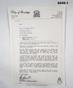
Document - APPROVAL FOR MONUMENT, Bendigo City Council, 9.7.1992
... The permits relate to the Building of a Monument...The permits relate to the Building of a Monument ...The permits relate to the Building of a Monument at the front of the Soldiers Memorial Institute Pall Mall Bendigo now known as the Bendigo Military Museum. Refer Cat No 8245.2.1) Document, white paper black print, blue pen hand written relating to permission to erect a Monument at the Soldiers Memorial Institute. .2) Document, white paper black print relating to the permit for .1) re the conditions applying to. Both items signed by C.C. Campbell Director Engineering and Technical Services..1) In blue pen, "RSL Bendigo Memorial Hall Pall Mall Bendigo - permit N0 - 096/92 - 39 Pall Mall - Statue" .2) "9.7.92 - C Campbell"brsl, smirsl, monument, documents, permit, -
 Bendigo Military Museum
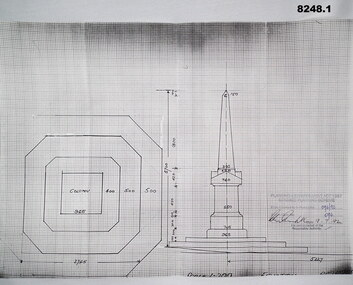
Plan - MONUMENT PLANS, 9.7.1992
All three pertain to the erection of a Monument in front of the Soldiers Memorial Institute in Pall Mall Bendigo to honour Ex Servicemen and Women. Refer Cat No 8245.2.1) Plan, white paper, black print on black graph paper showing front elevation and plan of a monument, signed, dated and stamped. .2) Plan, white paper black print showing plan and section A.A of same structure as .1). .3) Plan, white paper black print showing position of proposed monument as in .1) in front of a building with gardens surrounding. signed, dated and stamped.On all three written and stamped, " Planning and Environment Act 1987 Bendigo Planning scheme - Plan refrred to in Permit No 096/92 - Application No 096 (signature) 9.7.92 - for and on behalf of the responsible authority"brsl, smirsl, plans, monument -
 Eltham District Historical Society Inc
Document - Report, Paul Jerome, Advisory Committee on a Proposed Convenience Centre and an Alternative Shire Proposal - Eltham Gateway Community Precinct Concept Plan - 895 Main Road Eltham, October 1997
On 15 December 1994 the former Shire of Eltham ceased to exist following the Liberal Kennett Government local council amalgamations. A new Nillumbik Shire Council was established with unelected commissioners appointed. That Council sold the former Eltham Shire Council Offices and land at 89S Main Road Eltham to Dallas Price Homes Pty. Ltd. the sale being conditional upon the granting of a planning permit for a petrol station/convenience store, fast food and video outlet. The sale was conditional that if the permit was not granted by 30 August. 1997, the contract could be avoided by either the purchaser or the vendor. The proposed development consisted of a petrol station with undercover fuelling facilities, convenience shopping, a drive through service facility for fast food, an 80 seat cafe, automated banking, a children's play area and retail space. In addition, the proposal included a 200 square metre community facility for Council use, provision of on site carparking over 2 levels for 83 vehicles, and advertising signage. An Advisory Committee consisting of Dimitry Reed and Margaret Pitt was appointed under Section 151 of the Planning and Environment Act 1987 to hear submissions on the proposal to develop the land at 895 Main Road Eltham, the site of the former Eltham Shire Offices. In September 1996, two applications were made by Contour Consultants Australia Pty Ltd on behalf of Dallas Price Homes Ply Ltd, to Nillumbik Shire Council. After extensive notification, the Council received 213 objections and a petition of over 1400 signatures. On October 9, 1996, Nillumbik Shire Council issued Notices of Decision to Grant Permit on Applications number 96/03376 and 96/0377 for the use and development of the land as a convenience Centre consisting of a petrol station, convenience store, cafe/takeaway food premises, a retail facility and a community facility, with associated advertising signs. Objectors to the proposals lodged Planning Appeals number 96/40724 and 96/40812 with the Administrative Appeals Tribunal on November 1, 1996. The grounds of appeal can be summarised as: inappropriate development, insufficient carparking, traffic and access issues, unsatisfactory design, inadequate permit conditions, the proposal being out of character with the area. and being contrary to the purpose and orderly development of the Eltham Town Centre, excessive noise, lack of consultation and unsuitable signage. On November 13, 1996, the Minister for Planning and Local Government directed the Registrar of the Administrative Appeals Tribunal. under Section 41 (1) (a) of the Planning Act 1980, to refer the Appeals to the Governor in Council for determination without a hearing or recommendation by the Tribunal. The Minister for Planning and Local Government called in the Appeals as he considered that they raised major issues of policy relating to the facilitation of development in accordance with the objectives set out in Section 4 of the Planning and Environment Act 1987, and that determination of the Appeals could have a substantial effect on the achievement of these planning objectives. The Minister required the Advisory Committee to consider the planning merits of the proposed use and development, and to address the issues raised in the objections. The Advisory Committee was required to produce a report providing: • The Committee's response to the matters detailed; • Relevant supporting information for the Advisory Committee's recommendation; and • A description of the proceedings conducted by the Advisory Committee and a list of those consulted or heard by the Committee. In March 1997, elections were held in the Shire of Nillumbik and the view of the new Council to this proposal differed from the view held by the earlier Council Hence the Submission made to the Committee by the Shire was against the decision by the Shire of Nillumbik to issue the Notices of Decision to Grant a Permit. The Recommendations of the Advisory Committee were: i. The cafe and take away food premises are as of right uses and are therefore allowable, but that shop and petrol station are unacceptable uses. A community facility is a discretionary use and is acceptable. ii. A development of the type and scale proposed is totally inappropriate for this land and that the Applications number 96/03376 and 96/0377 for the use and development of the land as a convenience Centre consisting of a petrol station, convenience store, café/takeaway food premises, a retail facility and a community facility, with associated advertising signs, be refused. iii. The land should be rezoned for public purposes and should remain in the community's ownership for community use. Following this, the Minister for Planning and Local Government, the Hon. Robert Maclellan, appointed Mr. Paul Jerome as an Advisory Committee under section 151 of the Planning and Environment Act 1987 to consider a Convenience Centre and an alternative proposal by Iha Shire of Nillumbik being the Eltham Gateway Community Precinct Concept Plan for the site of the former Shire of Eltham municipal offices at 895 Main Road, Eltham. In summary, the terms of reference for the Advisory Committee required it to: • consider the merits of the Council proposal • examine the merits of both proposals in terms of net community benefit • address the report of the previous Advisory Committee on the Convenience Centre proposal The Advisory Committee inspected the site and considered all the material before It including submissions made by all parties to the previous Advisory Committee and correspondence received by the Department of Infrastructure both before and after that Committee submltted its report. The Advisory Committee also held discussions with the following people: • Cr. Robert Marshall • Cr. Margaret Jennings • Cr. Lex de Man • Mr. Dallas Howgate of Dallas Price Properties, also Dallas Price Homes • Mr. Barry Rochford, CEO, Shire of Nillumbik • Ms. Yvonne Rust, Planning Officer, Shire of Nillumbik • Mr. Gregory Burgess, Architect of the Eltham Library and of Council’s Community Precinct Concept Plan • Mr. Jim Connor representing Mrs Thelma Barkway of the Eltham Senior Citizens Club Having considered all the material before it, the Committee arrived at two basic conclusions. First, the DPP proposal should be rejected because, on its merits, It does not sufficiently satisfy the requirements of the planning scheme which is a statutory document. The planning scheme requires that, before making a decision on the permit applications for the DPP proposal, a range of matters must be considered. It follows that consideration of these matters should Influence the decision. These matters include local policies relating to character and amenity. In particular, these policies seek • to conserve and enhance the bushland/country atmosphere, artistic heritage and strong sense of community of the Eltham Town Centre by ensuring that the design and height of any new development is sympathetic to existing buildings • to achieve a pleasing physical environment within the Eltham Town Centre by encouraging a high standard of architecture and urban design • to encourage Improvement to pedestrian amenity through such facilities as open and shattered rest areas and meeting places, crossing facilities, pedestrian arcades, pedestrian links to car parks and pedestrian weather protection • to reduce conflict between vehicular traffic and pedestrian flows, and • to encourage pedestrian thoroughfares It is submitted, as set out In the main body of this report, that the DPP proposal fails substantially to meet these policies and In so doing does not merit the exercise of discretion In Its favour with the Issuing of a permit. This finding is not offset by the investment and employment attributes of the proposal. They do not override the need to comply with the planning scheme. Second, the Council proposal, on Its own merits, substantially meets all statutory requirements applicable to this site with a possible reservation about car parking and traffic management which need further definition and assessment as the concept is refined. The Council proposal, however, has a serious weakness in that Its financial viability has not been adequately tested. The Committee refers to 'financial' rather than 'commercial' viability in recognition that Council owns the land and may enter into a range of agreements and partnerships to realise its concept some of which may be truly commercial and some of which may involve an element of subsidy arising from Council's involvement as a public body acting on behalf of its community. The Committee concludes that Council should be given the opportunity, within a reasonable timeframe to establish the financial feasibility of its concept and should develop a strategy for the future of Its land asset at 895 Main Road in the event that Its concept for the site cannot be realised. 895 main road, advisory committee, dallas price homes, eltham, eltham shire office, nillumbik shire council, planning application, administrative appeals tribunal -
 Eltham District Historical Society Inc
Film - Video (VHS), Jenni Mitchell, Demolition of the Shire of Eltham Offices, 1996
Poor video quality (noise and interference), incomplete and unedited raw footage. A video documenting the demolition of the Shire of Eltham offices at 895 Main Road Eltham under the direction of the Commissioners appointed for the new Shire of Nillumbik and some of the communities activities surrounding the event. The building was demolished exactly 25 years after the southern wing housing Engineering and Planning on the upper level and the Eltham Library on the ground level was opened in celebration of the Shire of Eltham's centenary. Video has lots of distortion and noise, and sections of clips dubbed over. Immediate initial footage of Jenni Mitchell talking about asbestos claims in the Shire Offices (Sigmund Jorgensen standing behind her) advising Council did a review of the building several years previously and had been cleared of health problems. Cuts to group of people standing outside front door of offices but possibly voice dub over not related ? Then the date 27 Jul 1996 on a scene flashes on screen immediately followed by an edited clip intro of title and credits with classical music track. It then opens with Jenni Mitchell driving to the Shire Offices on Saturday 27 July 1996 at 11.00am. Footage of Main Road past Pitt Street, Alistair Knox Park then entering Shire Office driveway which is fenced off and contractor signs hanging up. Scenes at rear of building showing some internal demolition has commenced. View of the Administration wing. More clips of road driving, Alistair Knox Park, Eltham Library and visitor car park for Shire Offices. Cuts to a group of people standing in access to visitor carpark with new Eltham Library in background, one being immediate former Shire of Eltham President, John Graves. Scenes of people looking through chain link fence and security guard checking front door. John Graves being filmed that someone informed him the Shire was offering the building to the Community Health Centre for $2.3 million and that if they had been offered a price of $1.1 for what it apparently was sold for they would have snapped it up. View of truck loaded with brick rubble literally struggling to ascend the hill of Library Place to exit into Main Road. Cuts to a scene looking at Eltham War memorial Hall through the Memorial Gate, then the Shillinglaw trees and large banner sign ‘Delta Demolitions’ hanging on office façade. Views of front door, old library and bluestone wall. Scene (31 Jul 1996) filmed at night of several white crosses with “RIP Community” and “RIP Democracy”. Scene (1 August 1996) again driving along Main Road towards the Shire Offices then scenes of the offices showing substantially more demolition to exterior, groups of people standing on footpath outside watching, Delta heavy demolition machines, woman holding sign “Democracy where have you gone …”, the odd person in full protection gear and breathing apparatus hand carrying materials out to place on rubbish pile in front of people standing on footpath watching (with no protection) and then stamping on it to break it creating dust, security person in hard hat (no other protection) wandering around, many groups standing around watching, news film crew, person standing on roadside edge holding signs facing traffic stating “Pirate Planning” and “ Grant us your ears” also sign on back of parked car “Elthams High Jacks”, another sign “Community Democracy”, views of crosses in Main Road median strip “RIP Community”, groups of people on footpaths and reporters conducting interviews, footage of unknown person standing with Jenni Mitchell and Sigmund Jorgensen advising people have the right to protest, Jenni Mitchell urging people to ask questions of local MP and Council and Sigmund Jorgensen referring to the three historic Shillinglaw trees with demolition machinery operating in background, Jenni Mitchell and others installing more crosses in median strip; demolition machines operating inside and outside the building, more views of onlookers including Sigmund Jorgensen then Police approaching on footpath, workers and machinery continuing to operate, views of the old library being demolished, the former Community Services department, security personnel. Scene (2 August 1996) more heavy demolition machinery in operation smashing building up, people standing around southern wing watching, view overlooking Eltham Library of train pulling in to Eltham station. Scene (7 August 1996) more heavy demolition and people wandering around with only hard hat protection, no dust protection, comments from one operator dumping a bin of material stating “wait till there’s a Hungry Jack’s here, you’ll be laughing, fuel, videos, hamburgers. You’ll be up with the rest of the world soon, you’ll have electricity and everything here, ha ha ha ha”, more heavy machinery demolition and breaking up of materials, view of Hitachi train going by and Administration wing, view inside the front door opening of the staircase leading to upper level, person walking around operating heavy machinery with a hose spraying rubble (no protective gear other than hard hat interspersed with edit cuts of meeting of Commissioners and independent observers on panel as well as members of the community in public gallery. Nillumbik Shire CEO Barry Rochford addressing the meeting., Chief Commissioner Don Cordell directly addressing Jenni Mitchell with respect to permission to take photographs, Barry Rochford continues to address the question asked of Council about the valuation of the former Shire of Eltham Office building/site, public gallery calling out asking why was building demolished, what was the urgency. Scene (14 August 1996) views of southern wing, previous single demolition operator again mocking people filming, operators working in and around building, Shillinglaw trees and largely demolished front, heavy demolition equipment at work, piles of building rubble, hose spraying water over rubble, large trucks arriving for rubble removal and loading of truck. Scene (21 August) more of the same, building virtually down, Shillinglaw trees standing tall and alone, water spraying on rubble and wattle in bloom. Cuts to Council meeting with public onlookers. Barry Rochford walks out, Wayne Phillips addresses meeting explaining one or two people shouting, members of the community challenging Council (Commissioners) about why due process appear to have been subverted. Former Shire President Robert Marshall in public audience, cuts back to Shire office carpark entrance site and sign hung on fence in front of library “Think Again!” and people standing around observing awaiting a protest demonstration erecting a large sign on stilts stating “Shell No!”, people singing a revised version of God Save the Queen (God Save Us All), Sigmund Jorgensen in attendance, Jenni Mitchell, Sigmund Jorgenson and others address the protest crowd, followed by people mingling, music being played then people standing around the cleared site circumference all with arms linked (video very broken up with noise) then chants “Save the Gateway” and “No Shell for Eltham” and more music and singing “Put up a parking lot”. The crowd then proceeds to walk along the footpath of Main Road. Scene (15 Sep 1996) meeting at Montsalvat in Great Hall addressed by Sigmund Jorgensen discussing a recently published list of the Commissioner’s to senior Council Officers of banned Nillumbik people, others encouraging people to view proposed plans for the site and lodge objections. Specific issues regarding asbestos claims are also addressed. Harry Gilham addresses the meeting on the subject of the Eltham War Memorial and Memorial Gardens and how Council believe a roundabout in the vicinity is of greater importance. Views of various artworks on display (for auction) and music performance in the Barn Gallery. Meeting addressed by Sigmund Jorgensen discussing an appeal against Council granting a permit to Dallas Howgate to develop the site and that the Minister has called the matter in to be decided by the governing council. This is followed by an auction of paintings. 0.05 - Jenni Mitchel, Sigmund Jorgensen and Peter Doughtery in background. 0.18 - Jock Kyme in front of building – David Essex, Marg Johnson on his left-hand side. 5.34 - John Graves – ex Shire of Eltham Councillor and President. 9.02 - Unknown person being interviewed. 9.30 - Jenni Mitchell, unknown person, Mark Burns, community activist. 10.04 - Sigmund Jorgenson, Jenni Mitchell. 12.04 - Police members 21.33 - Nillumbik Council offices 7 August 1996 Barry Rochford CEO, Vin Heffernan Commissioner, Don Cordell Chief Commissioner, Kevin Abbott Commissioner, unknown person. 28.00 - Barry Rochford CEO 28.05 - Kahn Frankie - in commissioner’s seat after commissioners and council staff have vacated the council chamber. 28.26 - Wayne Phillips, State Liberal member for Eltham, addressing community in response to questions. 28.36 - Mark Burns, community activist addressing gallery. 28.48 - Ken Hines, ex Shire of Eltham Councillor and President. 29.34 - Ken Hines, ex Shire of Eltham Councillor and President standing, Robert Marshall, ex Shire of Eltham Councillor and President seated in front. 29.41 - Karen Gerhards, community activist. 30.06 - Marg Johnson with loud hailer, next to Jock Kyme, community activist. 31.32 - Marg Johnson with possibly Frank Burgoyne?, Sigmund Jorgensen, Jock Kyme. 35.35 - Harry Gilham at meeting at Montsalvat on 15 September 1996. 35.43 - Sigmund Jorgenson at lectern. 36.42 - Marg Jennings. 37.47 - Mark McDonald, Jim Connor, ex Shire of Eltham Councillor in background. 36.28 - John Cohen, ex Shire of Eltham Councillor and President. 38.56 - Ken Hines, ex Shire of Eltham Councillor and President. 41.11 - Harry Gilham, president of the Eltham District Historical Society. 43.55 - Sigmund Jorgensen in Long Gallery at Montsalvat, at start of the art auction to raise funds for community action. 45.50 - Unknown person conducting art auction. VHS Video cassette (poor quality) Converted to MP4 file format 45:01, 535MBvideo recording, 895 main road, alistair knox park, artworks, auction, barn gallery, barry rochford, community health centre, dallas howgate, delta demolitions, demolition, don cordell, eltham, eltham library, eltham shire office, eltham war memorial, eltham war memorial gate, eltham war memorial hall, great hall, harry gilham, jenni mitchell, john graves, library place, main road, memorial gardens, mervyn hannan, montsalvat, pitt street, protest, robert marshall, roundabout, shell oil, shillinglaw trees, sigmund jorgensen, sign, wayne phillips -
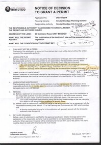 Bendigo Historical Society Inc.
Document - Gemma Starr collection - Bendigo East Primary School - folder contains documentation of the support and submission to Council to Save the Bendigo East Primary School Avenue of Honour
Gemma Starr collection - Bendigo East Primary School - folder contains documentation of the support and submission to Council to Save the Bendigo East Primary School Avenue of Honour. Folder covers: Zoning, Policy, Maps, Heritage, Amenity and Trees documentation. Submissions had concerns about the subdivision, and the removal of trees on the site, impacting the school building.social, local history, bendigo east primary school, planning permit and objections -
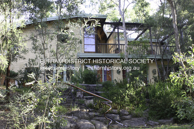 Eltham District Historical Society Inc
Photograph - Digital Photograph, Alan King, Busst House, cnr Silver Street and Kerrie Crescent, Eltham, 2 February 2008
Considered the best of the early mud-brick houses built by Alistair Knox. Covered under Heritage Overlay, Nillumbik Planning Scheme. Published: Nillumbik Now and Then / Marguerite Marshall 2008; photographs Alan King with Marguerite Marshall.; p143 The Busst house hidden by trees at the corner of Silver Street and Kerrie Crescent is considered the best of the early mud-brick houses built by Eltham architect, Alistair Knox. Knox himself said, that the Busst house was the most mature mud-brick house designed at that period. ‘It related with true understanding to its steep site and expressed the flexibility of earth building ………to develop a new sense of flowing form and shape’. Built in 1948 for artist Phyl Busst, a former art student at Montsalvat, the house helped usher in Eltham Shire’s distinctive mud-brick residential character. Knox was the pivotal figure of the style developed from the 1950s to the 1970s. Scarcity of building materials after World War Two encouraged mud-brick building because earth was a cheap and plentiful building medium. But when Knox began building in mud-brick in 1947, no council in Victoria knew anything of this ancient art and he needed a permit. Fortunately the Commonwealth Experimental Building Station at Ryde in NSW, had been experimenting with earth construction to help overcome the shortages of that time. They published a pamphlet that became available in Melbourne on the same day the Eltham Council was to consider whether the earth building should be allowed. Knox caught one of the three morning trains to the city in those days and bought several copies of the pamphlet to give to each councillor. On his return he found the councillors standing on the steps of the shire offices after lunch at the local hotel. He heard that earth building had been discussed before lunch and that they were not in favor of it. Knox gave each councillor a pamphlet. They passed that plan and by doing so, opened the door for all future earth building in Victoria and by default, in Australia. Mud-brick houses attracted artists to Eltham, for their aesthetic appeal and because they were cheap. Those who built their own houses, included film maker Tim Burstall, artists Peter Glass, Clifton Pugh, Matcham Skipper, Sonia Skipper and husband Jo Hannan. For Knox, mud-brick building was more than just a cheap building medium. He saw it as harmonising with the surrounding bush and as a way of counteracting the growing materialism of the age. He wrote of its impact on ‘ 20th century man. It should counteract the confusion that the perpetual flow of high technology products have upon him ..’ Building the Busst house on a steep site was difficult because most earth-moving equipment was then in its infancy. For instance drilling for explosives was done by hand, which was a slow and painful process. Knox, assisted by his foreman Horrie Judd and Gordon Ford (who was to become a famous landscape designer), built two large main rooms - a living room/ kitchen downstairs - and upstairs, a studio/bedroom. The studio/bedroom opens onto the balcony, which covers the living area. The bath made of solid concrete by stonemason Jack Fabro, is particularly deep. Sunshine pours through the three French windows of the north-east facing kitchen/living area, which is lined with timber. The large hearth can fit a family around the fire while the timber floors and solomite (compressed straw) ceilings add to the cosy atmosphere. The garden is thick with trees, and in the late 1990s, Ford put in a pool near the original dry wall he had built as a young man.This collection of almost 130 photos about places and people within the Shire of Nillumbik, an urban and rural municipality in Melbourne's north, contributes to an understanding of the history of the Shire. Published in 2008 immediately prior to the Black Saturday bushfires of February 7, 2009, it documents sites that were impacted, and in some cases destroyed by the fires. It includes photographs taken especially for the publication, creating a unique time capsule representing the Shire in the early 21st century. It remains the most recent comprehenesive publication devoted to the Shire's history connecting local residents to the past. nillumbik now and then (marshall-king) collection, alistair knox, alistair knox design, busst house, kerrie crescent, mudbrick construction, mudbrick houses, silver street