Showing 5020 items
matching crown
-
 Whitehorse Historical Society Inc.
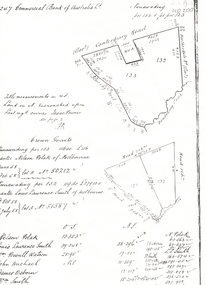
Legal record - Land Title, Crown grant, 1858
Commercial Bank of Australia record of Crown Grants of land to Nelson Polak and Louis Laurence Smith in 1858.Commercial Bank of Australia record of Crown Grants of land to Nelson Polak and Louis Laurence Smith in 1858. The land is between Canterbury Road, Heatherdale Road, 'Scoresby Road' (now Boronia Road) and the Dandenong Creek.Commercial Bank of Australia record of Crown Grants of land to Nelson Polak and Louis Laurence Smith in 1858. polak, nelson, smith, l l dr, canterbury road, vermont, boronia road, dandenong creek, heatherdale road, land sales -
 Buninyong & District Historical Society
Photograph - Original Photograph, Crown Hotel, Buninyong, from Learmonth St. in 1980's
Historic building in 1980'sColour photo of Crown Hotel Buninyong from Learmonth St. in 1980's. Original polychrome brickwork painted dark blue in 1960, and then cream after alterations 1980. Chimneys unpainted, show original brickwork.buninyong, crown hotel -
 Buninyong & District Historical Society
Photograph - Original Photograph, Clive Brooks, Crown Hotel, rear view from DeSoza Park, Nov. 1991
detail of historic buildingColour Photograph, Crown Hotel, rear view from DeSoza Park, Original 1885 slate roof surrounded by 1980's extensions, bottle shop on left, corner shop on other side of Warrenheip St. visible.buninyong, crown hotel, bottle shop -
 Buninyong & District Historical Society
Photograph - B/W photograph, Mr. C.J.Brooks, Crown Hotel Buninyong, cnr. Warrenheip and Learmonth Streets, 1993
Original wooden hotel built 1852, burnt down 1884 and replaced by current brick building.Licensed premises since gold rushB/W photo of Crown Hotel, Buninyong, two-story, gabled hotel, brick painted white, viewed across intersection, large Chinese Elm tree to left, which was destroyed in truck accident 6 May 2022.buninyong, crown hotel, building, streetscape, chinese elm -
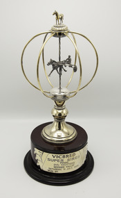 Victorian Harness Racing Heritage Collection at Lord's Raceway Bendigo
Memorabilia - Silver trophy, Maori's Crown, 1998 Vicbred Super Series Final 2yo trotters
Maori's Crown (The Contender Imp P 1.54.0 - Maori Mara Vic Tr 2.9.2 (Bravado Hanover)) Bay Mare. Foaled 1995 (9th Foal). Breeder/Owner: R McD Healy & Co Pty Ltd. Trainer: R McD Healy. Maori's Crown raced from 1998 (2yo) through to 2001 (5yo). Career: 8 wins 1 second 5 thirds 32 starts $57,060 2.06.2 Winning Drivers: BR Gath (4) BR Healy (3) MN Wishart (1). Won on 4 Tracks: Moonee Valley (5) Bendigo (1) Maryborough (1) Ballarat (1)Maori's Crown won the 1998 Vicbred Super Series Final 2yo Trotters at Moonee Valley over 1940m at a mile rate of 2.10.7. Driven by BR Gath. Defeating Claes 2nd and Mad Azz 3rd.Gold and Silver Trophy on a Wooden BaseVicbred / Super Series / Final / 2yo Trotters / Moonee Valley / Saturday 11 July 1998 / Won bytrotting, maoris crown, moonee valley, vicbred super series, 1998, ric healy, r healy, br healy, bryan healy, br gath, brian gath, b gath, b healy, r mcd healy -
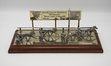 Victorian Harness Racing Heritage Collection at Lord's Raceway Bendigo
Memorabilia - Glass trophy, Maori's Crown, 1998 Edgar Tatlow Memorial 2yo Trotters
Maori's Crown (The Contender Imp P 1.54.0 - Maori Mara Vic Tr 2.9.2 (Bravado Hanover)) Bay Mare. Foaled 1995 (9th Foal). Breeder/Owner: R McD Healy & Co Pty Ltd. Trainer R McD Healy. Maori's Crown raced from 1998 (2yo) through to 2001 (5yo). Career: 8 wins 1 second 5 thirds 32 starts $57,060 2.06.2 Winning Drivers: BR Gath (4) BR Healy (3) MN Wishart (1). Won on 4 Tracks: Moonee Valley (5) Bendigo (1) Maryborough (1) Ballarat (1)Maori's Crown won the 1998 Edgar Tatlow Memorial 2yo Trotters at Moonee Valley over 1940m at a mile rate of 2.06.3. Driven by BR Gath. Defeating Heza Joule 2nd and Kellybrooke 3rd.Glass plaqueVicbred /Edgar Tatlow Memorial / 2yo Trotters / Moonee Valley 23 May 1998 / Won by / Harness Racing Victoria Designed and Handcrafted / in Australia by / Renown Silverwaretrotting, edgar tatlow, moonee valley, 1998, ric healy, r healy, br gath, brian gath, br healy, bryan healy, b gath, b healy, r mcd healy -
 Buninyong & District Historical Society
Photograph - Original Photograph, Crown Hotel, Buninyong, from Learmonth St. around 1905, around 1905
gold rush era historic building, social historyB/W photo, Crown Hotel, Buninyong, from Learmonth St. around 1905, shows some adjoining buildings inc. Caffrey's Shoeing Forge. Clearly shows original polychrome brickwork, full width iron lace veranda and tall flagpole.buninyong, crown hotel, learmonth st., warrenheip st, caffrey's shoeing forge -
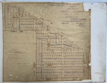
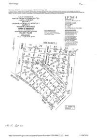 Ringwood and District Historical Society
Document - Subdivision Plan, LP26914 Multiple Crown Allotments, Parish of Ringwood, County of Mornington, Vol 8021 Fol 053 - 1954
LANDATA Land Victoria plan printout dated 2010Part of Crown Allotments 1, 1A, 2, 3, 4, 5, 6, 7, 8, 9, 10, 55, 56, 57. Section C Crown Allotments 3, 12 & part of 2. Section B Map includes Bedford Road, Government Road (later Bedford Park Road then Hill Street), Marwarra Street and Tooronga Road, Ringwood. (Sheet 1 of 2 - Sheet 2 not included with collection). -
 Greensborough Historical Society
Poster - Planning Document, Shire of Diamond Valley et al, Subdivision Plan # 1044 - Parish of Nillumbik, County Bourke, Crown Allotment B Section 12, Eltham North, 1981-1987
Subdivision Plan # 1044 - Parish of Nillumbik, County Bourke, Crown Allotment B Section 12, Eltham North. This subdivision plan includes Weidlich Road and St Clems Street. The developer for this subdivision is Taunton Developments and the Surveyors are Fisher Cleeland Turner & Dwyer Vic, Surveyors and Engineers.An example of hard copy subdivision plans from the Greensborough area. Mainly from the Shire of Diamond Valley era (1964-1994).Plan (single sided) mounted on heavy card. Stamped and handwritten Council permissions, dates and other details. subdivision plans, shire of diamond valley, taunton developments -
 Ringwood and District Historical Society
Document - Land Title, John Quinlan et al, Land title (Ringwood) and correspondence between George Pratt of Nunawading and the Commissioner of Crown Lands 1869-1877, 1869
Land title and correspondence between George Pratt and the Commissioner of Crown Lands and Survey dated 19th(?) August 1869. Numbered 16678 (1M) plus 20 pages marked 42M-61M +Additional Keywords: Commissioner of Land and Survey / Longmare, Mr. / Quinlan, John -
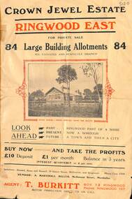 Ringwood and District Historical Society
Flyer, Subdivisional Land Sale Brochure, Crown Jewel Estate, Ringwood East, Vic. - c.1925
In May 1884, George Smart of Bulleen Road Kew, brickmaker, bought the 23 acres one rood and twenty nine and three tenths perches, or 9.4834 hctares from Arthur Bailey Clements of Ringwood for the sum of 600 pound sterling. (Extract from The Story of the Crown Jewel Estate in Ringwood East pdf)Double sided folded page with black and red print on both sides advertising auction sale of residential and business sites and highlighting local facilities, services and layout of the estate.Subdivision includes Mount Dandenong Road, Valda Avenue, Evon Avenue, Mirabel Avenue, and Velma Grove. (Agent) T. Burkitt, Box 12 Ringwood, Phone Ringwood 157. Vendor: A. Marshall Miller, McDonald Street, Mordialloc. Solicitors: Russell, Bona and Russell, 19 Queen Street Melbourne, and Ringwood - Phone Cent. 4308. -
 Greensborough Historical Society
Poster - Planning Document, Shire of Diamond Valley et al, Subdivision Plan # 1026 - Parish of Nillumbik, County Bourke, Crown Allotment B Section 12, Eltham North, 1981-1984
Subdivision Plan # 1026 - Parish of Nillumbik, County Bourke, Crown Allotment B Section 12, Eltham North. This subdivision plan includes Ryans Road (also known as Government Road) and St Clems Street. The developer for this subdivision is Taunton Developments and the Surveyors are Fisher Cleeland Turner & Dwyer Vic, Surveyors and Engineers.An example of hard copy subdivision plans from the Greensborough area. Mainly from the Shire of Diamond Valley era (1964-1994).Plan (single sided) mounted on heavy card. Stamped and handwritten Council permissions, dates and other details. subdivision plans, shire of diamond valley, taunton developments -
 Bacchus Marsh & District Historical Society
Map, Plan of Survey of Part of Crown Allotment 9, Parish of Korkuperrimul, 1890
This map documents a transfer of an allotment of land in Clarke Street Bacchus Marsh in 1890. Clarke Street is located on the eastern side of Bacchus Marsh not far from Main Street and Crook Street. It is now known as Candeloro Street. The map indicates J. Booth as the owner of the land and H. Simpson as the occupier. Next to this allotment is a an allotment of land owned by J. Elmore,Single page map showing Crown allotment 9, Parish of Korkuperrimul, County of Bourke. Scale 100 feet to inch. Part of a set of maps which are pasted into a bound volume containing 76 maps or plans in total. High resolution digital image stored on BMDHS computer network. At bottom of map: I hereby certify that I have made this survey expressly for the purpose of an application under the Transfer of Land Statute that this plan is correct. Barry B???, Lic. Surveyor, 16.10.90bacchus marsh victoria maps, clarke street bacchus marsh maps -
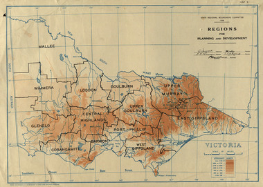 Federation University Historical Collection
Map, Victoria: Regions for Planning and Development, 1944, 1944
This map was produced for the State Regional Boundaries Committee Two colour map of Victoria showing the regions for planning and development. The regions are Central Highlands, Mallee, Wimmera, Glenelg, Corangamite, Barwon, Loddon, Goulburn, Upper Goulburn, Upper Murray, East Gippsland, West Gippsland, Port Phillip.central highlands, mallee, wimmera, glenelg, corangamite, barwon, loddon, goulburn, upper goulburn, upper murray, east gippsland, west gippsland, port phillip, victoria, m4486 -
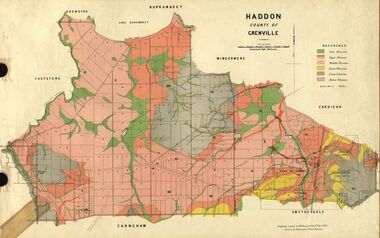 Federation University Historical Collection
Plan, Haddon, County of Grenville, 1887, 1889
Ferdinand Krause taught at the Ballarat School of MinesGeological Map of Haddon in the County of Grenville surveyed by Ferdinand Krause. haddon, grenville, krause, ferdinand krause, cgt, lake burrumbeet, windermere, chepstowe, bailies creek, snake valley lead, nentingbool preemptice right, cardigan state forest, haddon state forest -
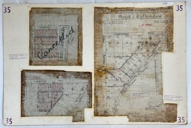 Greensborough Historical Society
Poster - Planning Document, City of Heidelberg, Subdivision Plan # 35 - Parish of Keelbundoora, Crown Portion 16, Watsonia, 1918
Subdivision Plan # 35 Parish of Keelbundoora, Crown Portion 16: 3 plans on one sheet. Plan 1: Lambourn Road, Boger Street, Kenmare Street, Greensborough Road, Devonshire Road, Watsonia (stamped "Superseded"). Plan 2: an update of plan 1. Plan 3: Also Lambourn Road, Boger Street, Kenmare Street, dated 1918, Shire of Heidelberg.An example of hard copy subdivision plans from the Greensborough area. Mainly from the Shire of Diamond Valley era (1964-1994).3 Plans (single sided) mounted on heavy card. Stamped and handwritten Council permissions, dates and other details. Plan 1 has been stamped in red "SUPERCEDED" and overwritten by hand "Cancelled".subdivision plans, city of heidelberg, greensborough, main street greensborough, shire of heidelberg, watsonia -
 Greensborough Historical Society
Poster - Planning Document, City of Heidelberg, Subdivision Plan # 19 - Parish of Keelbundoora, Crown Portion 16, Watsonia "Black's subdivision', 1924
Subdivision Plan # 19 - Parish of Keelbundoora, Crown Portion 16, Watsonia "Black's subdivision". This subdivision plan includes proposed street names which were later changed (e.g. Morwell Street (not Morwell Avenue) now called Greenwood Drive). Includes Lambourn Road, Black Street, Grace Street, Eden Avenue, High Street, Kenmare Street, Morwell Avenue, Greensborough Road, Mundy Street, Ladd Street.An example of hard copy subdivision plans from the Greensborough area. Mainly from the Shire of Diamond Valley era (1964-1994).Plan (single sided) mounted on heavy card. Stamped and handwritten Council permissions, dates and other details. subdivision plans, city of heidelberg, greensborough, main street greensborough, shire of heidelberg, watsonia, black family -
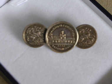 Warrnambool and District Historical Society Inc.
Tie Pin, Tie Pin half crown, Late 19th century
This tie pin has as its centerpiece a souvenir medal from the Warrnambool Industrial and Art Exhibition of 1896-7. This exhibition was held in the Town Hall and Council Buildings and the Mechanics’ Institute and temporary buildings at the corner of Liebig and Timor Streets, Warrnambool. It was held over three months and attracted many visitors and featured concerts, sports events, industrial exhibits and a variety of competitions. This is an interesting and important item. It is one of the more unusual mementoes from the Warrnambool Industrial and Art Exhibition and shows the use made of souvenirs from exhibitions around the world. This tiepin was purchased in an antique shop in England in the 20th century. This is a metal tie pin with three circular coins, soldered together at the edges. In the middle is a souvenir medal of the Warrnambool Industrial and Art Exhibition of 1896-7 showing an image of the Exhibition buildings at the corner of Timor and Liebig Streets on one side and a Coat of Arms on the other side. The two smaller coins on each side are imitation British half crowns. The clip at the back is soldered on to the two smaller coins Medal: Industrial Exhibition, Warrnambool 1896 Coins: 1889-90 warrnambool industrial and art exhibition 1896-7, warrnambool, tie pin -
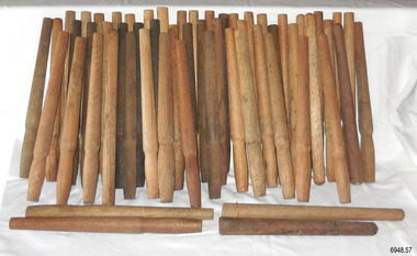 Flagstaff Hill Maritime Museum and Village
Equipment - Belaying Pins, Late 19th Century
The pins in this collection vary in the timber used and the design. They were found in a warehouse beside Crown Casino in Melbourne, located along the Yarra River, close to the sailing ship "Polly Woodside" and not far from the docks of Port Melbourne. Some of the pins have the mark of a 'Broad Arrow' with 'D ↑ D, which signifies that they were the property of the Australian Government's Department of Defence. Belaying pins are essential equipment on a traditional sailing ship of the 19th and early 20th centuries. They are usually made of wood but some are metal. A belaying pin is used to secure the running ropes of the rigging to the ship's rails using holes drilled onto the rails for that purpose. The belaying pins are inserted into holes in the ship’s rail, drilled for that purpose. When the sail has been raised, the ropes are wrapped around the upper and lower sections of the pins in a figure-eight pattern. The shapes of these belaying pins taper from the rounded end of the handle inwards towards the bottom, which allows them to have a firm fit into the holes in the rails. The rigging rope is wound around the pins in such a way that a tug on the pin's handle pulls it out of the hole and quickly frees the rope and the sail.These belaying pins are significant for their association with sailing vessels, particularly vessels of the late 19th and early 20th centuries. They are also significant for their association with the Port of Melbourne where sailing ships docked to and from the Port of Melbourne. Some of the pins have additional significance for being connected with the Australian Government's Department of Defence.Belaying pin, wooden, simple design, wooden shaft with a wider rounded end on top third, tapering to the centre third, which is wider than a lower third. The bottom has a blunt base. Some of the pins have the three sections divided by a line around their circumferences. This collection of fifty-seven pins of varying shapes, colours and timber. Some of the pins are stained with colour, and some have been left natural Stored in a wooden crate. Some have inscriptions.Marks: (Government Defence Department Broad Arrow) "D ↑ D"sailiing equipment, nautical equipment, rigging, yards, flagstaff hill, maritime museum, maritime village, belaying pin, broad arrow, australian government, australian department of defence, sailing ship, sail -
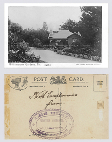 Williamstown Botanic Gardens- Hobsons Bay City Council
Postcard – Williamstown Botanic Gardens, The Crown Studios, Sydney, c1900-1920
The Curator’s lodge, designed by the Town Surveyor, HV Champion, was constructed in 1907 following the re-organisation of the north-east corner with the demolition of the old curator's cottage and erection of new gates. Lee Heap Furniture Warehouse of Williamstown used the postcards to advertise. The postcards are evidence of the interest the gardens held as a subject for postcard publishers. The text and images provide a snapshot into fashions, social interests and concerns of the time. The professionally produced images provide a pictorial history of Gardens including changing planting styles, various structures and features of the Gardens eg the aviary, cannons, the fountain, the second Curator’s Lodge and gates. The images offer an opportunity to compare garden vistas with the present day.A sepia image looking across a path bordered with rocks of a house (the Curators lodge) behind a fence. In front of the fence there is a young girl sitting on a rock with a young boy standing beside her. The house is timber with two brick chimneys, the right hand one half hidden by foliage. The house is federation style with timber battening above the front window. A timber frieze is above a verandah supported by three posts and light coloured brackets. Front: ‘Williamstown Gardens. Vic.’ ‘0457/1’ THE CROWN STUDIOS, SYDNEY’. Reverse: Centre top ‘POST CARD’ with a logo in the middle of the words. Left top corner a drawing of an artist’s board and brushes with a camera in the centre. Left side ‘MESSAGE ONLY.’ Right side ‘ADDRESS ONLY.’ Top right corner inside a dotted rectangle ‘STAMP HERE’. Bottom on card ‘BY THE CROWN STUDIOS, SYNDEY.’ Under the vertical line down the middle line ‘Neither the Address not the Message must cross this line’. In ink ‘With Compliments / from’. An oval stamp with scalloped rim ‘LEE HEAP FURNITURE MANUFACTURER’ inside inner oval ‘FURNITURE WAREHOUSE, / WILLIAMSTOWN’.postcard, gardens, post-card, williamstown-botanic-gardens, hobsons-bay-city-council, curator’s lodge, children, federation style, crown studios, lee heap furniture warehouse -
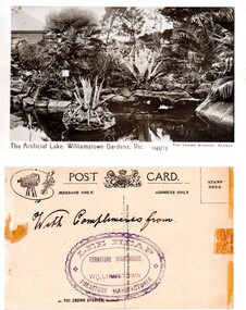 Williamstown Botanic Gardens- Hobsons Bay City Council
Postcard – Williamstown Botanic Gardens, The Crown Studios, Sydney, c1900-1920
The lake was built in 1904, during the curatorship of Mr Thake. Lee Heap Furniture Warehouse of Williamstown used the postcards to advertise. The postcards are evidence of the interest the gardens held as a subject for postcard publishers. The text and images provide a snapshot into fashions, social interests and concerns of the time. The professionally produced images provide a pictorial history of Gardens including changing planting styles, various structures and features of the Gardens eg the aviary, cannons, the fountain, the second Curator’s Lodge and gates. The images offer an opportunity to compare garden vistas with the present day.Sepia image of the ornamental lake and part of the Curator’s Lodge in the background on the left side of card. The small island with a succulent is in the centre of the image with a similar plant on the right side of it. The water is edged with rocks. Reflections of the plantings and lodge can be seen.Front: ‘The Artificial Lake, Williamstown Gardens. Vic.’ ‘0457/3’ ‘THE CROWN STUDIOS, SYDNEY’. Reverse: Centre top ‘POST CARD’ with a logo in the middle of the words. Left top corner a drawing of an artist’s board and brushes with a camera in the centre. Left side ‘MESSAGE ONLY.’ Right side ‘ADDRESS ONLY.’ Top right corner inside a dotted rectangle ‘STAMP HERE’. Bottom on card ‘BY THE CROWN STUDIOS, SYNDEY.’ Under the vertical line down the middle line ‘Neither the Address not the Message must cross this line’. In ink ‘With Compliments from’. An oval stamp with scalloped rim ‘LEE HEAP FURNITURE MANUFACTURER’ inside inner oval ‘FURNITURE WAREHOUSE, / WILLIAMSTOWN’.postcard, gardens, post-card, williamstown-botanic-gardens, hobsons-bay-city-council, ornamental lake, crown studios, lee heap furniture warehouse -
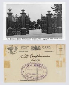 Williamstown Botanic Gardens- Hobsons Bay City Council
Postcard - Postcard – Williamstown Botanic Gardens, The Crown Studios, Sydney, c1900-1910
The cast iron gates (manufactured in Glasgow) introduced at the North West entrance in 1907. The gates were purchased from ‘Fairlie” corner of Acland and Anderson Streets, South Yarra at the cost of 72 pounds and cost 60 pounds to install. They had originally cost the owners of ‘Fairlie’ 1200 pounds. Lee Heap Furniture Warehouse of Williamstown used the postcards to advertise. The postcards are evidence of the interest the gardens held as a subject for postcard publishers. The text and images provide a snapshot into fashions, social interests and concerns of the time. The professionally produced images provide a pictorial history of Gardens including changing planting styles, various structures and features of the Gardens eg the aviary, cannons, the fountain, the second Curator’s Lodge and gates. The images offer an opportunity to compare garden vistas with the present day. The image in this postcard shows the gates intact and as installed in 1907. The current layout of this area still reflects the change of design, which followed the 1907 removal of the first gardener's residence and the subsequent re-organisation of this quarter of the gardens. This postcard is evidence of the placement of one of the cannons relocated from Fort Gellibrand in 1906. They were removed from the Gardens in the 1960s. These same cannons remain a feature on the Williamstown waterfront in 2013. Black and white image of main entrance gates which are open. Through the gates can be seen a man in waistcoat standing in front of a cannon. The gates are cast iron, double carriage gates with single pedestrian gates on either side and supported by four cast iron posts with ornamental finials. Front: ‘The Entrance Gates, Williamstown Gardens. Vic.’ ‘0457/2’ ‘THE CROWN STUDIOS, SYDNEY’. Reverse: Centre top ‘POST CARD’ with a logo in the middle of the words. Left top corner a drawing of an artist’s board and brushes with a camera in the centre. Left side ‘MESSAGE ONLY.’ Right side ‘ADDRESS ONLY.’ Top right corner inside a dotted rectangle ‘STAMP HERE’. Bottom on card ‘BY THE CROWN STUDIOS, SYNDEY.’ Under the vertical line down the middle line ‘Neither the Address not the Message must cross this line’. In ink ‘With Compliments / from’. An oval stamp with scalloped rim ‘LEE HEAP FURNITURE MANUFACTURER’ inside inner oval ‘FURNITURE WAREHOUSE, / WILLIAMSTOWN’.postcard, gardens, post-card, williamstown-botanic-gardens, hobsons-bay-city-council, entrance gates, entrance-gates, cast iron, finials, cannon, crown studios, lee heap furniture warehouse -
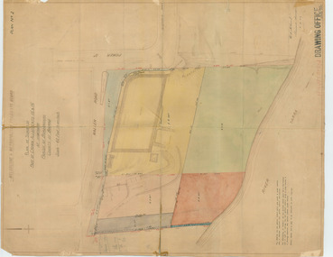 Melbourne Tram Museum
Drawing, "Plan of Survey of Part of Crown Allotments 15 and 16 at Hawthorn, Parish of Boroondara, County of Bourke", 1922
Drawing, coloured with water based drawing wash, titled "Plan of Survey of Part of Crown Allotments 15 and 16 at Hawthorn, Parish of Boroondara, County of Bourke". Shows the tram track, Wallen Road, changes around the intersection with Power St, buildings. A note at the bottom notes who owns what - MMTB and City of Hawthorn. Prepared by H. S. McComb, licensed Surveyor 6-9-1922. Stored folded.Stamped "Drawing Office" "Office Copy" and in red pencil "Hawthorn" in the bottom right hand corner, and on the rear "Drawing Office" "Office Copy" and "Hawthorn Depot" in pencil.trams, tramways, htt, mmtb, hawthorn depot, plans -
 Federation University Historical Collection
Plan, Plan of Survey Crown Allotment 9A and Part of Crown Allotment 8 Section 10 City and Parish of Ballaarat, after 1929
ink and watercolor on watermarked laid paper dated 1928text and measurementsballaraat, ballarat, plan, plan of survey, armstrong street, skipton street -
University of Melbourne, Burnley Campus Archives
Document, Crown Grant Land Description Crown Alltoment 16R Parish of Jika Jika, 1994-2007
Photocopies of Title documentscrown land, allotment, jika jika -
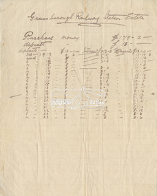
Stawell Historical Society Inc
Archive, Crown Cross Reef Gold Mine Co & Extended Crown Cross, Share Register, 1868
Listing NamesHand Writtenstawell, mining -
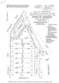 Ringwood and District Historical Society
Document - Subdivision Plan, LP12308 Crown Allotment 14C and Part of Crown Allotment 14A Parish of Ringwood, County of Mornington Vol 5378 Fol 511 - Circa 1927
LANDATA Land Victoria 4-sheet plan printout dated 2009.Sheet 1 includes Canterbury Road, Heathmont Road, Dickasons Road and Bennett Avenue, Heathmont. Additional markings include PC353066. Sheet 2 includes Heathmont Road, Bennett Avenue and Orchid Street, Heathmont. Additional markings include PS326369 and SP24567. Sheet 3 includes Dickasons Road and Bennett Avenue, Heathmont. Additional markings include LP46776, SP28005 and PS335189. Sheet 4 includes Dickasons Road, Bennett Avenue and Orchid Street, Heathmont. Additional markings include SP25998, SP31080, SP31780, SP25968, SP25969 and LP46475. -
 Eltham District Historical Society Inc
Document - Folder, Greensborough Railway Station Estate, Lots 26, 26A and 26B, Crown Portion 3, Parish of Nillumbik, County of Evelyn (Rattray Road, Montmorency)
Crown Portion 3 of Eltham, Parish of Nillumbik, County of Evelyn, Lots 26, 26A and 26B were part of the Greensborough Railway Station Estate. The land detailed is bounded by present-day Rattray Road, Reichelt Avenue, Wooded Way and Ryrie Court, Montmorency. Originally purchased in September 1913 by George William Miller, signwriter of Greensborough and Harry Frederick Miller, the land was sold to Mrs Margaret Barr Honeyman, 24 June 1918 on mortgage for £400, deposit paid £150. In February 1920, Mr Honeyman called for the title and paid off the loan early, settlement occuring 11 October 1920. Contents: 1. Handwritten payment plan (Sep 1913 to Mar 1923) for Lots 26, 26A and 26B being parts of Crown Portion 3, Parish of Nillumbik, County of Evelyn on the plan of subdivision making up the Greensborough Railway Station Estate situated on Rattray Road; purchased for £179.2.0 with a deposit of £18.0.0. 2. Receipt: From Messrs G.W. and H.F. Miller for £11.15.8 being instalment and interest, 9 Sep 1913 3. Invoice: To Messrs G.W. and H.F. Miller for £11.12.0 being instalment and interest due 15 Sep 1914 4. Contract of Sale: George William Miller and Harry Frederick Miller to Mrs. Margaret Barr Honeyman, in respect of sale of Lots 26, 26A and 26B for £400.0.0, 24 June 1918. Deposit of £150.0.0 balance to be paid half yearly instalments of £15 with interest at 5% per annum added. 5. Letter: Percy J. Russell, Solicitor to G.W. Miller, 5 Feb 1920 advising Mr Honeyman has called for the title and wishes to pay off mortgage. 6. Letter: Percy J. Russell, Solicitor to G.W. Miller, 11 Oct 1920 advising settlement and payment of Miller to Honeyman.contract of sale, george william miller, greensborough railway station estate, harry frederick miller, land sale, margaret barr honeyman, montmorency, rattray road, reichelt avenue, ryrie court, wooded way -
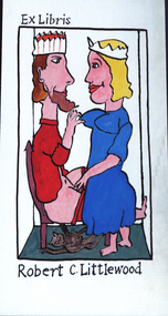 Federation University Art Collection
Artwork - bookplate, Andrew Sibley, Bookplate for Robert C. Littlewood, 2014
Bookplate featuring a couple wearing crownscrown, robert littlewood -
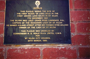 St Kilda Historical Society
Photograph, Plaque marking the site of the first block of land sold in the first Crown Land Sales in St Kilda 7 Dec 1842, c. 1980s?
colour photograph unmounted (2 identical photographs)This plaque marks the site of the first block of land sold in the first Crown Land Sales in St Kilda 7 Dec 1842. The buyer was Lieut. James Ross Lawrence, R N, Captain of the Schooner 'Lady of St Kilda'. He named Acland st after Sir Thomas Dyke Acland, owner of "The Lady of St Kilda". This plaque was unveiled by Commander RS Veale RAN (retd) CMG for St Kilda City Council. 24 March 1985.