Showing 1511 items matching "land use"
-
 University of Melbourne, Burnley Campus Archives
Plan, Plan of Richmond Park, 1872
... Garden without extra land used for Field Station (see 11.0363... Horticultural Society's Garden without extra land used for Field Station ...Plan of Richmond Park L4461. Shows Horticultural Society's Garden without extra land used for Field Station (see 11.0363, but earlier). Surveyed and drawn by A.L. Martin, Authorized Surveyor. Photo-lithographed at the Department of Lands and Survey, 6th Sept. 1872.Handwritten notes on reverse and another railway line marked in pencil.railway lines, swan street, yarra river, richmond park, horticultural society, orchard -
 Lorne Historical Society
Map, F W Niven Lithos, The Mountjoy Lorne Estate, 1889
... allotments, with their owners, and naming land use. It has four black..., and naming land use. It has four black and white line drawings ...In 1888 a company was formed to acquire and subdivide the land of the Mountjoy Brothers. The land totaled 197 acres and included Erskine House. The land colored red was that of the Mountjoys. The subdivision map was printed in 1889A paper map of the Mountjoy Estate Lorne , showing allotments, with their owners, and naming land use. It has four black and white line drawings , Erskine House, Mountain View’s, the Rapids, Erskine House sea view and Erskine Falls. The map is largely black and white with red and blue colouring. The map is mstuck to brown paper. lorne, subdivision map, erskine house, mountjoy brothers, -
Port Melbourne Historical & Preservation Society
Booklet, State Government of Victoria, Making the Most of the Bay, 1990
... booklet considering environment, land use and settlement... booklet considering environment, land use and settlement ...Making the Most of the Bay - Plan for the protection and development of Port Phillip and Corio Bays, November 1990. An A4 booklet considering environment, land use and settlement, recreation and tourism, coastal and marine industries. Detailed recommedations for specific areas and foreward by Ministers Steve Crabb and Andrew McCutcheon (ref. item 1414, draft version)state government victoria, natural environment - conservation -
Whitehorse Historical Society Inc.
Certificate - Land Title, McCracken Orchards, 2000
... covering the land used as an orchard by the McCracken Family 1898... of Certificates of Title and lodged plans covering the land used ...Collection of Certificates of Title and lodged plans covering the land used as an orchard by the McCracken Family 1898 - 1962, comprising Cert. of Title vol 2699, Fol 660; Crown Portion 96, 1864 (part), Crown Portion 96, 1996; lodged plans 3681, 19126, 22255, 22256, 33386, with brief history prepared by P. Simmenauer.mccracken, john, mccracken, george, blackburn south, orchard grove, blackburn south, mccracken avenue, blackburn south, stewart avenue, blackburn south, lawrence street, blackburn south, wilton, edward, canterbury road, blackburn south, barns street, blackburn south, ralph street, blackburn south, horkings street, blackburn south, st ninians uniting church, blackburn south -
Moorabbin Air Museum
Booklet (Item) - International Civil Aviation Organization Airport Planning Manuals, Airport Planning Manual
... Contains information about master planning and land use... and land use Soft cover booklets Airport Planning Manual Booklet ...Contains information about master planning and land use -
 Federation University Historical Collection
Booklet - Report, Report and Recommendations to the Council of the School of Mines and Industries, Ballarat on the Master Plan for the Mt Helen Development, 11/1968
... , library, car parking, site, landscape, land use study, Mt Helen..., site, landscape, land use study, Mt Helen Site, L.H. Vernon ...A master plan for the campus was developed by L.H. Vernon and Associates. Geoff J. Harrison prepared a report and made recommendations on the master plan, including suggestions for improvement. Grey card covered, stapled, foolscap report on the Mount Helen Development. It included 14 typed pages and 6 plans. The report covers: Campus planning, Mt Helen Master Plan, retention of trees, sports fields, student accommodation, student amenities, library, car parking, site, landscape, land use study, Mt Helen Site, L.H. Vernon.mount helen master plan, masterplan, master plan, vernon, g.j. harrison, harrison, education, topography, survey, jd fisher, aa jeffreys, hugh mitchell, john vernon, geoff harrison, mount helen master plan, l.h. vernon, campus plan, mount helen campus -
 Kiewa Valley Historical Society
Maps - Tawonga and Feathertop
... Plan of Tawonga showing roads etc, rivers, use of land... etc, rivers, Parishes and use of land. 2. Feathertop 813. 1969... of Tawonga showing roads etc, rivers, use of land in 1968 ...Plan of Tawonga showing roads etc, rivers, use of land in 1968 and of Feathertop in 1969.Historical use of land in Tawonga and Feathertop.1. Topographical Map - Tawonga 803 Forests Commission of Victoria 1968. Cream paper with black print. Legend: Roads, tracks etc, rivers, Parishes and use of land. 2. Feathertop 813. 1969tawonga map 1968, tawonga parishes, feathertop map 1969 -
Greensborough Historical Society
Maps, Plenty River, 1837o
... These maps show the land use along the Plenty River. Both... Plenty Lower Plenty melbourne These maps show the land use along ...These maps show the land use along the Plenty River. Both Aboriginal and white settlements are shown.Set of maps showing the Plenty River. -
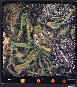
 Heidelberg Golf Club
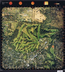
Photograph - Aerial Photograph, Heidelberg Golf Course 2000, 01/05/1980
... , showing the course layout and surrounding land use.... layout and surrounding land use. Aerial photographs Heidelberg ...Aerial photograph of Heidelberg Golf Club course in 1980, showing the course layout and surrounding land use.Aerial photograph, colour.Printed on edge of photo: "Colour proof", "LandSur756"aerial photographs, heidelberg golf club, lower plenty -
 Heidelberg Golf Club
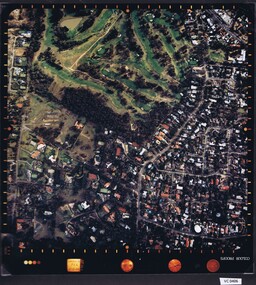
Photograph - Aerial Photograph, Heidelberg Golf Course 2000, 01/05/1980
... , showing layout of course and surrounding land use.... of course and surrounding land use. Aerial photographs Heidelberg ...Aerial photograph of Heidelberg Golf Club course in 1980, showing layout of course and surrounding land use.Aerial photograph, colour.Printed on edge of photo: "Colour proof", "LandSur756"aerial photographs, heidelberg golf club, lower plenty -
 Heidelberg Golf Club
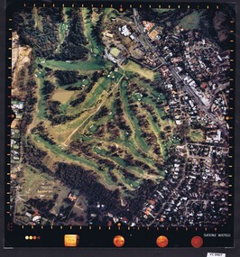
Photograph - Aerial Photograph, Heidelberg Golf Course 2000, 01/05/1980
... , showing layout of course and surrounding land use.... of course and surrounding land use. Aerial photographs Heidelberg ...Aerial photograph of Heidelberg Golf Club course in 1980, showing layout of course and surrounding land use.Aerial photograph, colour.Printed on edge of photo: "Colour proof", "LandSur756"aerial photographs, heidelberg golf club, lower plenty -
 Heidelberg Golf Club
Photograph - Aerial Photograph, Heidelberg Golf Course 2000, 01/05/1980
... , showing layout of course and surrounding land use.... of course and surrounding land use. Aerial photographs Heidelberg ...Aerial photograph of Heidelberg Golf Club course in 1980, showing layout of course and surrounding land use.Aerial photograph, colour.Printed on edge of photo: "Colour proof", "LandSur756"aerial photographs, heidelberg golf club, lower plenty -
Clunes Museum
Document - REPORT, HEPBURN SHIRE, 2024
... TO LANDSCAPE VARIATION AND DRIVERS OF LAND USE CHANGE... TO LANDSCAPE VARIATION AND DRIVERS OF LAND USE CHANGE ...PLANNING POLICY PRINCIPLES WILL BE TAILORED TO RESPOND TO LANDSCAPE VARIATION AND DRIVERS OF LAND USE CHANGE AND THE DIFFERENTIAL IMPACT THAT THESE HAVE ACROSS THE SHIRE....1 RURAL HEPBURN - AGRICULTURAL LAND STUDY AND RURAL SETTLEMENT STRATEGY, UNBOUND REPORT PRINTED IN COLOUR ON PAPER, 94 PAGES .2 FUTURE HEPBURN - CLUNES STRUCTURE PLAN, UNBOUND REPORT PRINTED IN COLOUR ON PAPER, 67 PAGES ADOPTED BY HEPBURN SHIRE COUNCIL 3 SEPTEMBER 2024hepburn shire council, rural settlement strategy -
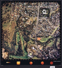
 Greensborough Historical Society
Folder, Aerial Imaging - Plenty River: by Ian Bryant, 2011_11
... Investigates early land use along the Plenty River from... Plenty Lower Plenty melbourne Investigates early land use along ...Investigates early land use along the Plenty River from north of the main aqueduct crossing in Greensborough to south of the golf course in Lower PlentyHistorical features seen from aerial and satellite images of the modern landscape may indicate earlier agricultural land usage.9 x A4 pages of text and colour annotated maps downloaded from nearmap.com.plenty river, ian bryant, lower plenty, greensborough, yallambie park, aerial photography -
![Photograph - Digital image, Willis Vale [Cows], 1920c](/media/collectors/4f729f5697f83e03086015b8/items/5502a0be2162f11024c30d9c/item-media/5502a0e52162f11024c31072/item-fit-380x285.jpg) Greensborough Historical Society
Greensborough Historical SocietyPhotograph - Digital image, Willis Vale [Cows], 1920c
... Flat Greensborough. Land use included farming and orchards. ... on the Plenty River at Partington's Flat Greensborough. Land use ...Photograph of four cows at Willis Vale, home of the Partington family. It was located on the Plenty River at Partington's Flat Greensborough. Land use included farming and orchards. Home of the Partington familyDigital copy of black and white photograph.willis vale, partington -
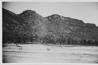
Stawell Historical Society Inc
Book - Report, Grampians: A Report on recreation and Timber Uses of. Too Steep to Graze - Too Rocky to Plough, 1979
... 1) Conservation & Economics 2) Grampians Study Area 3) Land...) Land Use 4) Management 5) Criticisms of the Management Plan ...1) Conservation & Economics 2) Grampians Study Area 3) Land Use 4) Management 5) Criticisms of the Management Plan Appendix Graphs & MapsGreen Paper cover: Black tape on SpineConservation council of Victoria and Logo -
 Greensborough Historical Society
Document - Planning Document, Diamond Valley Civic Centre and Neighbourhood Unit: Planning Proposal, 1960s
... This document proposes the change of land use from farming...This document proposes the change of land use from farming ...This document proposes the change of land use from farming and quarrying to residential. This also includes the proposal for a Civic Centre in the (then) Shire of Diamond Valley. The plans listed in the 'Schedule of Plans' on last page are missing.Includes proposal for the Aqueduct to be converted to an underground system. Includes statistics relating to population increase. Dark brown plastic folder. 23 foolscap-size pages. Maps, Application for Permits to subdivide land in the Greensborough area.partington family, mitchell family, whittingham family, albion reid, diamond valley civic centre, shire of diamond valley -
 Federation University Historical Collection
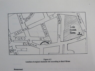
Report, Concept Study for the Further Development of the Eureka Stockade Reserve Conservation Plan, Vol 3, c1992
... together with current and proposed land uses. * Eureka Stockade... and proposed land uses. * Eureka Stockade location eureka eureka ...The objectives of the study were to * gather historical data and confirm the cultural significance of the site and reserve. * review existing site conditions including ownership together with current and proposed land uses. * Eureka Stockade location Copy of a 38 page report called "Concept Study for the Further Development of the Eureka Stockade Reserve Conservation Plan Vol 3", published by Ballarat University College. Authors are not stated. eureka, eureka stockade, ballarat university college, bert strange, bob o'brien, weston bate, alec barnett, jack chisholm, lloyd jenkins, eureka stockade location, cultural significance, eureka stockade site -
 Greensborough Historical Society
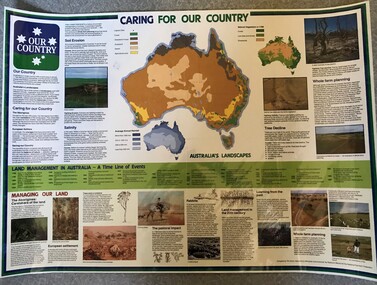
Poster, National Farmer's Federation et al, Caring for our Country, 1988c
... showing present land use and vegetation coverage in 1788. Prepared... 1988 to 1987. Includes maps showing present land use ...A timeline of land management including indigenous care and the impact of European settlement from 1988 to 1987. Includes maps showing present land use and vegetation coverage in 1788. Prepared by Tim Gurry for the National Farmer’s FederationLaminated poster, printed in colour on one side.land management, farming, salinity -
 Whitehorse Historical Society Inc.
Letter - Correspondence, Postal land - Blackburn, 1/06/1924
... , orchardist, re compulsory acquisition of land for postal use. He... of land for postal use. He was paid 264 pounds. Postal land ...Letter from the Crown Solicitor to Edgar Erikson, orchardist, re compulsory acquisition of land for postal use. He was paid 264 pounds.land titles, eriksson, edgar, junction road, blackburn north, australia. crown solicitors office, johnston, louisa caroline, station street, box hill, post offices -
 Melbourne Tram Museum
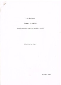
Document - Report, Melbourne & Metropolitan Tramways Board (MMTB)?, Ministry of Transport?, "East Burwood Tramway Extension - Middleborough Road to Vermont South - Feasibility Study, Oct. 1981
... and land use, existing services, patronage, operating costs... and land use, existing services, patronage, operating costs ...Report - 43 pages, photocopied, stapled in top left hand corner - titled "East Burwood Tramway Extension - Middleborough Road to Vermon South - Feasibility Study - October 1981". No details as who made the report, assumed Ministry of Transport or MMTB. Gives details of proposals considered, population and land use, existing services, patronage, operating costs, revenue and provides an assessment. Looks at costs for an extension only to Blackburn Road, Springvale Road and to Vermont South. Report showed the cost benefit ratio for Blackburn Road was 1, and less for the other possibilities.trams, tramways, east burwood, feasibility study, new tramway, mmtb, middleborough rd, vermont south -
 Bendigo Historical Society Inc.
Slide - RALPH BIRRELL COLLECTION: EIG SCHOOL, c1966
... . Gives a good idea of what the land was used for prior... grazing on site. idea of what the land was used Kodak EIG School ...EIG School - Ralph Birrell Collection. - Construction of Latrobe Uni. C1966. Bendigo Institute of Technology, Engineering School, Applied Science. Cow grazing on site or nearby site. Gives a good idea of what the land was used for prior to construction.Kodakeducation, tertiary, latrobe university bendigo, eig school - ralph birrell collection. - construction of latrobe uni. c1966. bendigo institute of technology, engineering school, applied science. cow grazing on site. idea of what the land was used -
Bialik College
Plan (item) - Site development proposals, Shakespeare Grove, 1986
... of existing land use and site constraints. Please contact archives... Project Management, October 1986. Includes plan of existing land ...Site development proposals for 6 Shakespeare Grove, Hawthorn, as part of the Bialik College Strategy Plan, created by Jennings Project Management, October 1986. Includes plan of existing land use and site constraints. Please contact [email protected] to request access to this record.1980s, building and planning -
 Melbourne Tram Museum
Document, Maidstone Tram Maintenance and Stabling Facility - Proposed Plans - Planning Approval
... stage - site plans, perspective, land use and sight lines from... plans, perspective, land use and sight lines from various ...Provides the proposed plans for the Maidstone Tram Maintenance and Stabling Facility - Proposed Plans - Planning Approval stage - site plans, perspective, land use and sight lines from various locations. The information booklet looks at the project steps, planning approval, heritage issues, environmental, construction, timing and operations.Yields information about the proposed Maidstone tram depot.Digital copy of a 13 A3 page document titled - Maidstone Tram Maintenance and Stabling Facility - Proposed Plans - Planning Approval and a 12 A4 page Information booklettrams, maidstone, tramways, new depot -
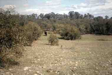
 Halls Gap & Grampians Historical Society
Postcard - B/W
... land was used for grazing purposes.... range from the Halls Gap side. the cleared land was used ...The Wonderland range from the Halls Gap side. the cleared land was used for grazing purposes.Photo shows peaks in background with cleared land in the foregroundPost Card Correspondence Address 122 Grampiansscenery, wonderland range -
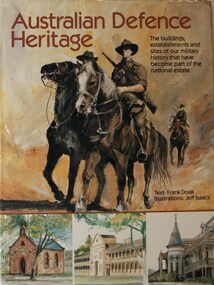 4th/19th Prince of Wales's Light Horse Regiment Unit History Room
Book, Australian Defence Heritage, 1988 (exact)
... hectares of land used either as training areas or for operational... The Department of Defence controls more than two million hectares of land ...The Department of Defence controls more than two million hectares of land used either as training areas or for operational and logistic bases. Approximately 200 Defence-occupied buildings have been classified by the Australian Heritage Commission and placed on the Register of the National Estate, and a further 100 buildings have been registered by the National Trust. Twenty properties also have been listed by the Australian Heritage Commission for significant environmental aspects and for the protection of Aboriginal sites. This book, produced as a contribution to Australia's bicentennial, is the first publication devoted entirely to Australia's priceless defence heritage. Text: Frank Doak Illustrations: Jeff IsaacsISBN 949 054 968heritage, books, defence estate, national estate, national trust, aboriginal sites, australian heritage commission, defence properties, frank doak, jeff isaacs, fairfax library, heritage, books, defence estate, national estate, national trust, aboriginal sites, australian heritage commission, defence properties, frank doak, jeff isaacs, fairfax library -
Federation University Historical Collection
Book, Land COnservation Victoria, Land Conservation Council Victoria Report of the North Eastern Area (district 1), 1972, 1972
... . Includes land use, recreation, agriculture, apiculture, vegetation... and brown soft covered book with brown tapespine. Includes land use ...Yellow and brown soft covered book with brown tapespine. Includes land use, recreation, agriculture, apiculture, vegetation, birds, water physiography, geology, climate, soils, fauna, land systems. Block descriptions include Bethanga, granya, Lawson, Walwa,Pine Mountain, Mittamatite, Elliot, Bunroy, Wabba, Mount Cadgewa, ucyvale, Koetan, Burrowa. Black and white images include Mitta Mitta arm, Corryong, Tallangatta, Lake Hume, Aboriginal rock shelter at Mount Porcupine, Koetong uplands, Mitta Mitta massif, bandicoot, wombat, skink, Flaggy Creek plateau, Walwa, Murray Cod, Thowgla, emu, grasstree, land conservation, north-eastern victoria, environment, landuse, recreation, timber, apiculture, water, upper murray, vegetation, birds -
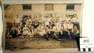 Myrtleford and District Historical Society
Hop Growers Photograph, "Panlook Boys, 1934"
... and unreliable tobacco prices brought a change in land use. ... in land use. The photograph represents the transition ...The photograph represents the migratory labour force involved in hop growing, the major farm activity on "Panlook's Hop Gardens", Eurobin in 1934. William Panlook a descendant of a Chinese storekeeper on the Buckland Diggings, had originally commenced tobacco growing at the location until devastating frosts and unreliable tobacco prices brought a change in land use. The photograph represents the transition that occurred from tobacco to hops cultivation in the early 1930s. It is now a permanent feature of the farming landscape at Eurobin. It depicts the reliance on migratory seasonal labour and the importance of local expertise, some of Chinese descent. A sepia-coloured photograph of 30 hop pickers.Inscription: "The Panlook Boys, 1934"hop growing. panlooks hop gardens. eurobin -
 Kiewa Valley Historical Society
Report - Alpine Study Area Volume 2 Maps, Land Conservation Council, 1970s
... Conservation Council (LCC) have completed 36 land use investigations... (LCC) have completed 36 land use investigations over more than ...The Victorian Environmental Assessment Council and the former Environment Conservation Council (ECC) and Land Conservation Council (LCC) have completed 36 land use investigations over more than 35 years, including 27 regional reviews. They provide a framework for use of Public Land in Victoria. The Land Conservation Council was established by the Land Conservation Act 1970.These maps provide an assessment of the Alpine area at the time the maps were created. Some of the topics eg. Rainfall and water resources may change over the years thus providing a comparative analysis. Others may provide information for future development such as mineral exploration, building of a dam / tunnel etc.Blue box shaped folder containing 9 of 10 Maps of the Alpine Study Area produced by the Land Conservation Council. Maps include 1. Public land and descriptive blocks. 2. Physiography. 3. Topography. 4. Geology (missing). 5. Rainfall and water resources. 6. Vegetation 7. Land systems. 8. Recreation. 9. Primary production. 10. Minerals Ex library item. Stamped in red "Discarded From Stock / Swan Hill Regional Libraryalpine area, maps of alpine area, land conservation council