Showing 268 items matching "melbourne metropolitan area"
-
 Port Melbourne Historical & Preservation Society
Document - Police circular, Victorian Police, 21 Feb 1953
Police circular 21 Feb 1953. Foolscap sheet, typed both sides, duplicated, punched both edges. Detailing arrests in the metropolitan area 9 am 20.2.53 to 9 am 21.2.53, listing a stowaway arrested at Port MelbourneThree names hghlighted in green. Blue tick on one item.police, crimes and misdemeanours -
Port Melbourne Historical & Preservation Society
Map - Wharves and Fisherman's Bend, MMBW, 17 Jan 1894
MMBW plan of Number 9 Wharf Area and Fisherman's Bend, 1894pencil writing addedmmbw, melbourne and metropolitan board of works, fishermans bend -
Port Melbourne Historical & Preservation Society
Map - Yarra River, Saltwater River and Coode's Canal, 1935
Plan No.7. Yarra River, Saltwater River, Coode's Canal area 1935.Signed Walker A.W.melbourne, a w walker, melbourne and metropolitan board of works, mmbw -
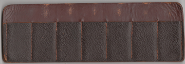 Tramway Heritage Centre
Ticket Holder, Unknown
A leather ticket holder for conductors to use to store books of tickets, it can hold seven books on either side for a 14 books of tickets.One side is showing wear and has markings where the leather is worn down around the area that the ticket book staples would be, the other side shows no markings.ticket holder, ticket, mmtb, m&mtb, melbourne & metropolitan tramways board -
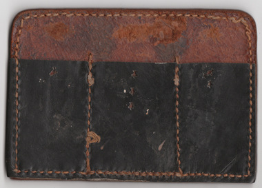 Tramway Heritage Centre
Ticket Holder, Unknown
A leather ticket holder for conductors to use to store books of tickets, it can hold three books on either side for a six books of tickets.Both sides are showing wear and have markings where the leather is worn down around the area that the ticket book staples would be.ticket holder, ticket, mmtb, m&mtb, melbourne & metropolitan tramways board -
Port Melbourne Historical & Preservation Society
Plan - Melbourne and suburbs sewerage works, MMBW, 1 Jul 1908
MMBW map of Melbourne and Suburbs sewerage work to 1-7-1908. Reticulation areas in red, reticulation areas under construction in blue.engineering - canals and drainage, engineering - board of works -
Port Melbourne Historical & Preservation Society
Plan - Annotated and handcoloured by Peter Libbis to indicate his research into Libbis family residences and hotels on copy of a section of an MMBW map, Melbourne and Metropolitan Board of Works, c. 1980s
Peter LIBBIS obtained these copies from the MMBW when he researched his family history in the 1980s. He has annotated them, colour in hotels etc. Donated to Society in 1997.One of a group of 19 photocopies of various 20th century MMBW plans, annotated/coloured in to indicate residences of Libbis family and local hotels, by Peter LIBBIS in family and hotel research - Bay/Crockford area, Ingles to Bridgebusiness and traders - hotels, built environment - domestic, transport - railways, melbourne and metropolitan board of works, libbis family -
Port Melbourne Historical & Preservation Society
Plan - Annotated and handcoloured by Peter Libbis to indicate his research into Libbis family residences and hotels on copy of a section of an MMBW map, Melbourne and Metropolitan Board of Works, c. 1980s
Peter LIBBIS obtained these copies from the MMBW when he researched his family history in the 1980s. He has annotated them, colour in hotels etc. Donated to Society in 1997.One of a group of 19 photocopies of various 20th century MMBW plans, annotated/coloured in to indicate residences of Libbis family and local hotels, by Peter LIBBIS in family and hotel research - Cruikshank/Pickles area (South Melbourne mostly)business and traders - hotels, built environment - domestic, transport - railways, melbourne and metropolitan board of works, libbis family -
Port Melbourne Historical & Preservation Society
Document, Melbourne and Metropolitan Board of Works, 31 Oct 1935
Documentation of drainage works in 1935 for 141 Bridge St.Plan of drainage 31/10/1935. Details the Melbourne and Metropolitan Board of Works drainage plan for part of Port Melbourne. 141 Bridge St, Port MelbourneHand written details around blueprint of area. Notes made on right hand side and 3 signatures at the bottom.built environment - civic, built environment - domestic, engineering - board of works, melbourne and metropolitan board of works, mmbw, m h grover, r f bentley -
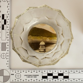 Melbourne Water
Souvenir confectionery bowl, 1930s-40s
Melbourne Water inherited many of its water assets, such as reservoirs from its predecessor the Melbourne Metropolitan Board of Works (MMBW). They have served the organisation well and have long been celebrated for both their natural beauty and engineering ingenuity. In the nineteenth century Victoria’s fundamental need for water infrastructure went beyond merely functional solutions and reflected the English ideal of the romance and beauty that was embodied in expanses of water. The MMBW further enhanced this notion by incorporating beauty and function in to the Classical and Italianate designs of its infrastructure such as pumping houses and reservoir outlet towers. The reservoir gardens and picnic areas were landscaped with ornamental stonework, exotic trees, decorative flower beds, fern glades pools and rose gardens. All features of the water supply system became widely celebrated as beauty spots that continue to be very popular to this day with tourists and locals alike. This souvenir is a product of that flourishing tourist trade. These water supply sites continue to enhance Melbourne’s charm and liveability and are now recognised as places of cultural and historic significance. This souvenir item has been curated by Melbourne Water as it represents an important historical aspect of the organisation by demonstrating the popularity of its water asset sites as recreational places and tourist attractions, and although these sites are functional parts of the water supply system, they were also designed to be enjoyed by the public both aesthetically and recreationally. Clear glass flower shaped 'depression ware' confectionery bowl, with photographic image of Maroondah Reservoir outlet tower on basemelbourne metropolitan board of works, mmbw, maroondah reservoir, melbourne water, scenic view, souvenir, glass bowl -
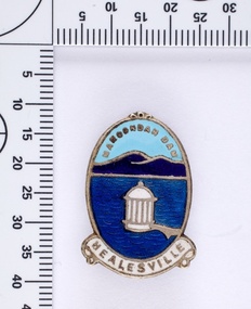 Melbourne Water
Souvenir lapel pin/brooch Maroondah Dam, 1960s/70s
Melbourne Water inherited many of its water assets, such as reservoirs from its predecessor the Melbourne Metropolitan Board of Works (MMBW). They have served the organisation well and have long been celebrated for both their natural beauty and engineering ingenuity. In the nineteenth century Victoria’s fundamental need for water infrastructure went beyond merely functional solutions and reflected the English ideal of the romance and beauty that was embodied in expanses of water. The MMBW further enhanced this notion by incorporating beauty and function in to the Classical and Italianate designs of its infrastructure such as pumping houses and reservoir outlet towers. The reservoir gardens and picnic areas were landscaped with ornamental stonework, exotic trees, decorative flower beds, fern glads pools and rose gardens. All features of the water supply system became widely celebrated as beauty spots that continue to be very popular to this day with tourists and locals alike. This souvenir is a product of that flourishing tourist trade. These water supply sites continue to enhance Melbourne’s charm and liveability and are now recognised as places of cultural and historic significance. This souvenir item has been curated by Melbourne Water as it represents an important historical aspect of the organisation by demonstrating the popularity of its water asset sites as recreational places and tourist attractions, and although these sites are functional parts of the water supply system, they were also designed to be enjoyed by the public both aesthetically and recreationally. Blue enamel and metal lapel pin/brooch depicting Maroondah Reservoir and outlet tower. Oval shaped with words 'Maroondah Dam' at the top and a ribbon banner containing 'Healesville' at the bottom. Maroondah Dam. Healesvillemelbourne metropolitan board of works, mmbw, maroondah reservoir, melbourne water, scenic view, souvenir, lapel pin, brooch -
 Melbourne Water
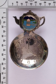
Souvenir tea caddy spoon "Tea Time", Early 1960s
Melbourne Water inherited many of its water assets, such as reservoirs from its predecessor the Melbourne Metropolitan Board of Works (MMBW). They have served the organisation well and have long been celebrated for both their natural beauty and engineering ingenuity. In the nineteenth century Victoria’s fundamental need for water infrastructure went beyond merely functional solutions and reflected the English ideal of the romance and beauty that was embodied in expanses of water. The MMBW further enhanced this notion by incorporating beauty and function in to the Classical and Italianate designs of its infrastructure such as pumping houses and reservoir outlet towers. The reservoir gardens and picnic areas were landscaped with ornamental stonework, exotic trees, decorative flower beds, fern glads pools and rose gardens. All features of the water supply system became widely celebrated as beauty spots that continue to be very popular to this day with tourists and locals alike. This souvenir is a product of that flourishing tourist trade. These water supply sites continue to enhance Melbourne’s charm and liveability and are now recognised as places of cultural and historic significance This souvenir item has been curated by Melbourne Water as it represents an important historical aspect of the organisation by demonstrating the popularity of its water asset sites as recreational places and tourist attractions, and although these sites are functional parts of the water supply system, they were also designed to be enjoyed by the public both aesthetically and recreationally. Tea caddy spoon with clock face engraved showing 4pm on round spoon, tea pot shaped handle with enamel scenic view badge saying 'Healesville' ( depicting Maroondah Reservoir outlet tower). Tea caddy spoon box labelled 'Fine Silverware by Stokes'Stokes and Sons Stokes & Sons logo (Star with S and boomerang) EG. No. 15733melbourne metropolitan board of works, mmbw, maroondah reservoir, melbourne water, scenic view, souvenir, tea caddy spoon -
 Melbourne Water
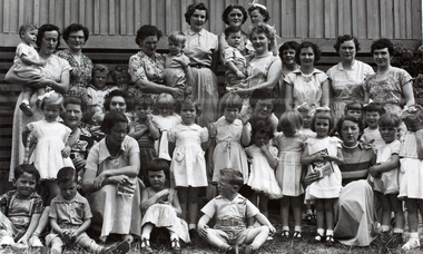
Photograph, Upper Yarra Dam Personnel, 1955
As the Yarra became unsuitable as a source of water, several attempts were made to find alternative sources for the growing population of Melbourne. It was not until 1891 that the efforts to sewer Melbourne came to fruition with the setting up of the Melbourne Metropolitan Board of Works (MMBW), now known as Melbourne Water. From 1891 until 1992, it was the responsibility of the MMBW to safeguard public health by providing a sewerage system and a safe water supply system. In 1992, The MMBW merged with a number of smaller urban water authorities to form Melbourne Water. In 1946, the Melbourne and Metropolitan Board of Works (MMBW) approved a site for a new dam for Melbourne's domestic water. This is now known as the Upper Yarra Dam. Due to the construction of the dam, the workforce had to be accommodated on site; domestic quarters were built for single men, families and staff. The township also had kitchens, laundry facilities, a canteen, a recreation hall, mess areas and a co-op store, with one of the first houses being seconded to accommodate for a school. This photograph shows personnel at a Kindergarten party at the Upper Yarra Dam, a time where workers were housed during its construction. The photograph is historically significant as it captures a purpose built community that supported the workers undertaking the construction of the dam. upper yarra dam, mmbw, melbourne metropolitan board of works, township, 1940s, community -
 Melbourne Water
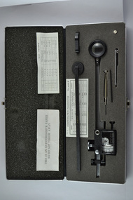
Compensating Polar Planimeter, c.1970s
As the Yarra became unsuitable as a source of water, several attempts were made to find alternative sources for the growing population of Melbourne. It was not until 1891 that the efforts to sewer Melbourne came to fruition with the setting up of the Melbourne Metropolitan Board of Works (MMBW), now known as Melbourne Water. From 1891 until 1992, it was the responsibility of the MMBW to safeguard public health by providing a sewerage system and a safe water supply system. In 1992, The MMBW merged with a number of smaller urban water authorities to form Melbourne Water. This item was used by MMBW employees as a measuring device to determine areas or figures on a plane surface having either straight or irregular boundaries. The Compensating Polar Planimeter is of historical significance for its association with the former Melbourne and Metropolitan Board of Works (MMBW). This measuring device is perfectly intact and a rare surviving object of standard Board issued equipment. The kit is significant for its representativeness of the theme of Technology in building Victoria's industries and workforce, which continues to resonate strongly within Melbourne Water today.The instrument is inside a black metal case with accessories including: Setting bar, screwdriver, Allen key and spare pole point. Inside is also the adjustable planimeter. mmbw, melbourne water, melbourne metropolitan board of works, technology, instrument, work, measure, historic, water, staff -
Bendigo Historical Society Inc.
Document - BROADCASTING STATION 3CV, MARYBOROUGH, 2 March, 1956
Broadcasting Station 3CV, Maryborough. A souvenir of the opening of the New Studios and Offices of Central Victoria Broadcasters Pty Ltd. March 2nd, 1956. Established 1956, offices in Burke Street, opening coincides with the stations 21st birthday, March 2 for the former celebration, October 26 for the latter. Coverage included Bendigo, Ballarat, Daylesford, Castlemaine and Maryborough. 3CV plays active part in assisting charities and hospitals at Maryborough, Daylesford, Maldon and Dunolly. Active Women's Radio Club with branches in country centres adds strength to station's charitable efforts. Opening 3CV's new premises will widen the scope of the station's charitable efforts, and stronger link with Australian Commercial Broadcasting stations. Writer Harold V Nunn writes history of district of Mayborough. Manager Ken J Parker, Central Victoria Broadcasters Pty. Ltd. The Souvenir brochure also covers topics such as: deep lead mining. WWI. Houses being pulled down. New settlements of Mildura. Secondary Industries. Bowenvale, Alma, Majorca, Craigie, Amherst, Adelaide Lead, Havelock, Bet Bet, Bently. Primary production and a railway staff of approximately 150. Maryborough a little town without a future. Coal fields at Wonthaggi. 1917 a public meeting was convened in an effort to stem the tide of adversity. Mayor George Frost, M.L.A., decision to form a Progress Association, a policy of secondary industry was decided upon and committees were appointed, James L Drew much credit is due. Maryborough's move for rejuvenation was revolutionary, because apart from Ballarat, Bendigo and Geelong, it was regarded as so much presumption that industry could be expected to function with success in a country town. Governments were unsympathetic. Maryborough & district people showed determination to succeed and their faith in their town. Employment and economic security provided by the industries outweighed the debt. Maryborough's general position is that it is no longer dependent upon one particular phase of activity. The first of the industries to be formed in 1918 was the Butter Factory. The nearer dairy companies did not take kindly to the prospect of another opposition company taking supplies from their districts, and in the first few years of establishment completion made the going hard for the management. But adopting a conservative policy and placing all profits to reserve I the first six years of operation headway was gradually made. Thus it was a red letter day for the company in 1925 when the first dividend of 5 percent was paid.1955 dividend of 10 per cent. Operating it's own trucks the dairy serviced local dairymen up to 40 miles. Maryborough Knitting mills est. 1923, having transferred from Clunes. Out bid Ballarat and Bendigo to the industry. The mill has what is probably the largest circular underwear plant in the Commonwealth, which is conservatively valued at 198,913 pounds. It produces between four and five million garments each year, worth over one million pounds. The company has established subsidiary mills at Dunolly, Talbot and Avoca. The company also assisted in the establishment of the Interknit Hosiery Co. Ltd., Clunes. The Maryborough Flour Mills is the second oldest of Mayborough's industries. It was built by Mr Cadwallader over 70 years ago. It was later sold to Mr. A Land and then to Jas. Minifie & Co. It had a somewhat 'in-and -out' existence until purchased in 1923 by Messrs. Willersdorf and Forbes, of Eddington. In 1939 the firm began to build silos for the storage of bulk wheat and the present storage capacity is 100,000 bushels. 1944 power was changed from steam to electricity. The mill has an out put of 20 sacks an hour. 1938 a chaff mill was built, and now is regarded as one of the best in Victoria. Its output in one year of approximately 6,800 tons is a State record for a single cutter. During this 30 year period Patience and Nicholson Limited has grown with Maryborough and is now one of the major key industries of Australia. The P&N brand covers precision tools - taps, dies and twist drills - indispensable to the country's economy, and quality is acknowledged equally by an air craft factory in Canada, a dockyard in Thailand, a railway workshop in New Zealand, no less than by our own Australian industries. Maryborough can be proud of the part played by P&N in war when, geared to the needs of the times, it poured countless millions of tools into defence factories and to the armed forces of the Allies, and now in peace when it is providing, hydro-electric undertakings and the manufacture of cars and tractors. From 1858, W Phelan & Sons Pty Ltd has made phenomenal and spectacular growth, becoming incorporated as a private company in 1929. It is without doubt the greatest private development in the history of Maryborough. 1940 joinery manufacture was commenced. The company entered the Ready Built Housing field in `950 - and in 1951 established a factory at Cairns, Northern Queensland to overcome the manufacturing difficulties being experienced due to the shortage of plywood in Victoria. Present activities include: Ready Built Housing Factory, on-site building, a modern joinery, timber yard, drying kilns, etc., and plumbing & electrical & engineering services, a door and panel factory at Cairns, retail hardware store, Melbourne Sales Depot. Hedges & Bell Pty Ltd were est 1945, with a staff of 40 employees are the largest printing firm outside the metropolitan area. The branch of Premier Wireworks is a contribution made by the decentralisation policy of the State.event, official, celebration, broadcasting station 3cv, maryborough. a souvenir of the opening of the new studios and offices of central victoria broadcasters pty ltd. march 2nd, 1956. established 1956, offices in burke street, 21st birthday. coverage bendigo, ballarat, daylesford, castlemaine maryborough. assisting charities and hospitals maldon and dunolly. women's radio club opening 3cv's new premises australian commercial broadcasting stations. writer harold v nunn writes history of district of mayborough. manager ken j parker, central victoria broadcasters pty. ltd. souvenir brochure: deep lead mining. wwi. houses pulled down. new settlements. primary production railway staff. coal fields wonthaggi. 1917 a public meeting was convened in an effort to stem the tide of adversity. mayor george frost, m.l.a., form a progress association, policy of secondary industry, james l drew rejuvenation was revolutionary, employment and economic security. the first of the industries to be formed in 1918 was the butter factory. thus it was a red letter day for the company in 1925 when the first dividend of 5 percent was paid.1955 dividend of 10 per cent. operating it's own trucks serviced local dairymen. maryborough knitting mills est. 1923 largest circular underwear plant in the commonwealth. established subsidiary mills at dunolly, talbot, avoca. interknit hosiery co. ltd., clunes. the maryborough flour mills it was built by mr cadwallader. mr. a land jas. minifie & co. messrs. willersdorf and forbes, build silos for wheat storage capacity is 100, 000 bushels. 1944 power was changed from steam to electricity. 20 sacks an hour. 1938 a chaff mill was built, best in victoria. patience and nicholson limited the p&n precision tools - taps, dies and twist drills. war, geared to the needs of the times, countless millions of tools into defence factories the armed forces of the allies, hydro-electric undertakings and the manufacture of cars and tractors. from 1858, w phelan & sons pty ltd, incorporated 1929. 1940 joinery manufacture. ready built housing field in 1950 - 1951 established a factory at cairns, northern queensland to overcome the manufacturing difficulties being experienced due to the shortage of plywood in victoria. present activities: ready built housing factory, on-site building, a modern joinery, timber yard, drying kilns, etc., and plumbing & electrical & engineering services, a door and panel factory at cairns, retail hardware store, melbourne sales depot. hedges & bell pty ltd were est. 1945, with a staff of 40 employees are the largest printing firm outside the metropolitan area. the branch of premier wireworks is a contribution made by the decentralisation policy of the state. -
 City of Whittlesea
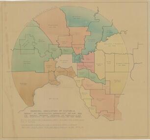
Map - Maps, Municipal Association Of Victoria groupings of councils for representation, 1936
Map was produced as part of Municipal Association of Victoria report on Metropolitan Government, 18 May 1936. Map shows proprosed groupings of municipalities for election of representation to the MAV Board. Map includes net annual value of rateable property within each municipality. The net rateable value for metropolitan area of the Shire of Whittlesea in 1936 was £20,102. Maps, paper. Produced as part of Municipal Association of Victoria report on Metropolitan Government, 18 May 1936. Map shows proprosed groupings of municipalities for election of representation to the MAV Board. council, municipal association of victoria -
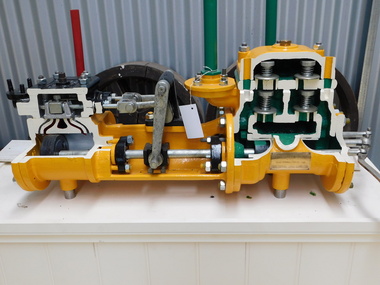 Puffing Billy Railway
Sectioned Tangye Steam Operated Water Pump, 1900s
Sectioned steam pump so that the pump workings can be seen. Inscriptions & Markings: Tangye Birmingham, This steam pump was presented by the colonial gas Assn Ltd (brass plaque) The Colonial Gas Association was originally formed in London on 2 February 1888, as The Australasian Gas Association Limited. The primary objective of the company was to provide investment capital to help finance the construction and management of gasworks being established by the London engineering firm John Coates & Co in metropolitan cities and regional towns throughout Australia and New Zealand. By 1890, the Australasian Gas Association had acquired gasworks at Benalla, Shepparton, Wangaratta, Warragul, Maldon and Seymour, and had constructed a large gasworks at Box Hill to supply the eastern suburbs of Melbourne. In 1893, the company's name was changed to the Colonial Gas Association Limited. During the 1890s, the company acquired regional gasworks in Queensland, Western Australia and South Australia, followed by its first gasworks in New South Wales, in 1911. In 1914, the company consolidated its metropolitan supply area by purchasing the Oakleigh and Footscray gasworks. Further expansion occurred in the 1920s with the purchase of established gasworks at Williamstown, Frankston and Dandenong and the acquisition of ten further gas undertakings in Queensland and New South Wales, making the firm the fifth largest gas producer in Australia. info from The Colonial Gas Association Limited, circa 1893 https://collections.museumvictoria.com.au/items/1553322 Originally formed by the five Tangye brothers from Cornwall as James Tangye & Brothers in 1857, this Birmingham engineering firm grew to become one of the largest suppliers of jacks, pumps, steam and oil engines, hydraulic presses, gas producers and machine tools in the late 19th and early 20th centuries. The successful sideways launching of I.K. Brunel's 'Great Eastern' from the mud of the Thames in 1857 using Tangyes hydraulic jacks gave the firm much needed publicity and new orders flowed in. To finance expansion, George Price provided additional capital and the company name became Tangye Brothers & Price in 1859. A new factory known as the 'Cornwall Works' was built in Clement Street, Birmingham. In 1872, the firm became Tangye Brothers and in about 1879- 1880 began production of internal combustion stationary engines based on Horace Robinson's patents, later using the Otto four-stroke design for its Soho range of gas engines. Examples of the Soho engine were exhibited by the firm at the 1880 Melbourne International Exhibition. Petrol and oil engines were made from the 1890s onward, and by 1910 had developed into the Model B, BR and AA series engines. Tangyes supplied custom-built pumps and presses for particular applications, becoming a major exporter of engineering equipment. In 1884, Tangye Brothers opened a custom-built branch office, showroom and warehouse in Melbourne at Cornwall House in Collins Street West, advertising the full range of engineering products. These lantern slides images are taken from Tangyes product catalogues from the 1910-1925 period and are believed to have been used as sales promotional aids in Australia by the Tangye Brothers. info from https://collections.museumvictoria.com.au/articles/4670 Historic - Industrial Steam Operated Water Pump built by Tangye Bros and used by the Colonial Gas Company - Melbourne, Victoria, AustraliaSectioned steam pump so that the pump workings can be seen. Tangye Birmingham, This steam pump was presented by the colonial gas Assn Ltd (brass plaque)puffing billy, steam pump, sectioned, tangye bros -
Clunes Museum
Book - DIRECTORY OF VICTORIA, SANDS & McDOUGALL PTY. LTD, DIRECTORY OF VICTORIA FOR 1935
DIRECTORY OF VICTORIA 1935 COMPRISING MELBOURNE AND SUBURBAN STREETS, COUNTRY POSTAL CENTRES.ALPHABETICAL ALL TENEMENT HOLDERS IN THE METROPOLITAN, BALLARAT, BENDIGO, AND GEELONG AREAS, BUSINESS AND PROFESSIONAL PERSONS THROUGHOUT VICTORIADARK RED HARDCOVER WITH ADVERTISING ON COVER AND INSIDE. PART OF THE SPINE IS MISSING 2180 PAGES non-fictionDIRECTORY OF VICTORIA 1935 COMPRISING MELBOURNE AND SUBURBAN STREETS, COUNTRY POSTAL CENTRES.ALPHABETICAL ALL TENEMENT HOLDERS IN THE METROPOLITAN, BALLARAT, BENDIGO, AND GEELONG AREAS, BUSINESS AND PROFESSIONAL PERSONS THROUGHOUT VICTORIAdirectory of victoria 1935, victoria 19354, sands & mcdoougall's -
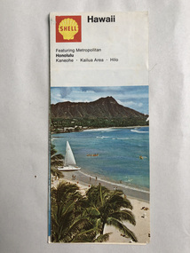 Robin Boyd Foundation
Map, Shell Touring Service, Hawaii
Featuring Metropolitan Honolulu, Kaneohe, Kailua Area, Hilowalsh st library -
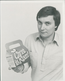 Uniting Church Archives - Synod of Victoria
Photograph, Curt Bjerking & Easter Eggs, 12/1986
"A Melbourne artist has launched a one-man campaign in the metropolitan area to fight the overcommercialisation of Easter... Curt Bjerking, 40, a graphic artist for 22 years, is an expert in packages…"Young man shown holding a cardboard box of Easter eggs.C&N identification.bjerking, curt, c&n, easter eggs -
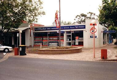 Hume City Civic Collection
Photograph, Prior to 1995
This corner was occupied in the past by Lloyds Chemist shop which was a weatherboard structure. The photograph was taken prior to 1995 when 8 digit telephone numbers were introduced throughout the Metropolitan area.A coloured photograph of the streetscape of the SW corner of Evans and Brook Street. The main shop is occupied by L. J Whorlow, Real Estate Agents. A white car is parked on the LHS of the photograph and a garbage bin is placed next to a concrete bollard by the kerb and on the brick paved footpath.real estate agents, shopping centres, whorlow, l. j., lloyd, l. m., first national real estate, evans street, brook street, george evans collection -
 Hume City Civic Collection
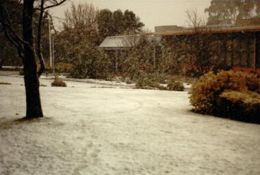
Photograph, 1/08/1986
A series of photographs were taken when heavy snow fell in Sunbury in August 1986. The snow began falling overnight and remained on the ground for 24 hours. Snow fell across the metropolitan area during that 24 hour period in a very unusual event for the area.A coloured photograph of the new main entrance to the former Shire of Bulla Council Offices and the garden immediately outside the portico area. The trees are bare and the lawn is covered with snow.snow falls, weather patterns, shire of bulla council offices, george evans collection -
 Hume City Civic Collection
Photograph, 1/08/1986
A series of photographs were taken when heavy snow fell in Sunbury in August 1986. The snow began falling overnight and remained on the ground for 24 hours. Snow fell across the metropolitan area during that 24 hour period in a very unusual event for the area.A coloured photograph of the front of the former Shire of Bulla Council Offices and front garden during a snow storm. The lawn area is covered with snow.snow falls, weather patterns, shire of bulla council offices, sunbury police station, george evans collection -
 Hume City Civic Collection
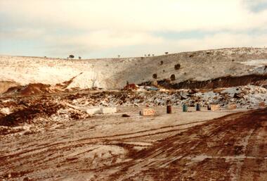
Photograph, 1/08/1986
A series of photographs were taken when heavy snow fell in Sunbury in August 1986. The snow began falling overnight and remained on the ground for 24 hours. Snow fell across the metropolitan area during that 24 hour period in a very unusual event for the area.A coloured photograph of the Sunbury Municipal Tip after the snowfall.snow falls, weather patterns, winter, sunbury municipal tip, george evans collection -
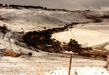
 Hume City Civic Collection
Photograph, 1/08/1986
A series of photographs were taken when heavy snow fell in Sunbury in August 1986. The snow began falling overnight and remained on the ground for 24 hours. Snow fell across the metropolitan area during that 24 hour period in a very unusual event for the area.A coloured photograph taken in the early morning after snow had fallen. The surrounding countryside around Mt. Holden is snow covered.snow falls, weather patterns, winter, mt. holden (mt. lion), george evans collection -
 Hume City Civic Collection
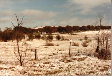
Photograph, 1/08/1986
A series of photographs were taken when heavy snow fell in Sunbury in August 1986. The snow began falling overnight and remained on the ground for 24 hours. Snow fell across the metropolitan area during that 24 hour period in a very unusual event for the area.A snow scene taken in the Sunbury area.snow falls, weather patterns, winter, george evans collection -
 Hume City Civic Collection
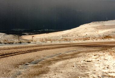
Photograph, 1/08/1986
A series of photographs were taken when heavy snow fell in Sunbury in August 1986. The snow began falling overnight and remained on the ground for 24 hours. Snow fell across the metropolitan area during that 24 hour period in a very unusual event for the area.A coloured photograph of a snow scene taken near the bridge on the Konagaderra Road near Sunbury.snow falls, weather patterns, winter, konagaderra road, george evans collection -
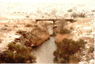
 Hume City Civic Collection
Photograph, 1/08/1986
A series of photographs were taken when heavy snow fell in Sunbury in August 1986. The snow began falling overnight and remained on the ground for 24 hours. Snow fell across the metropolitan area during that 24 hour period in a very unusual event for the area.A coloured photograph of the valley overlooking the Sunbury Sewerage farm and Eadie Hill after snow had fallen.snow falls, weather patterns, winter, sunbury sewerage farm, george evans collection -
 Whitehorse Historical Society Inc.
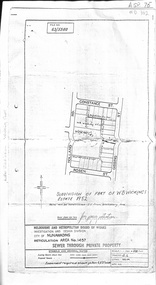
Document, Subdivision of part of W.B. Wickings Estate, 1952
Plan of subdivision of part of W.B. Wickings Estate, 1952. Reticulation area 1457, Sewer through private property. Melbourne and Metropolitan Board of Works document.land subdivision, holland road, blackburn south, constance street, gissing street, rosen street, wicking court, melbourne and metropolitan board of works, sewerage and sanitation, wicking, walter benjamin -
Whitehorse Historical Society Inc.
Article, Board agrees to Mitcham plan, 1962
The Board of Works has agreed to Mitcham's proposal that the whole Mitcham Junior School area eventually should become a shopping car park.The Board of Works has agreed to Mitcham's proposal that the whole Mitcham Junior School area eventually should become a shopping car park. Mitcham's long range plan is to get the Education Department to agree to move the school to another site. This proposal first originated through Mitcham Chamber of Commerce, has already been before the State Government and the Education Department. The M.M.B.W. said it would not favour re-zoning to the east of Mitcham Road.The Board of Works has agreed to Mitcham's proposal that the whole Mitcham Junior School area eventually should become a shopping car park.shopping centres, mitcham shopping centre, melbourne and metropolitan board of works, mitcham chamber of commerce