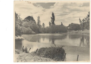
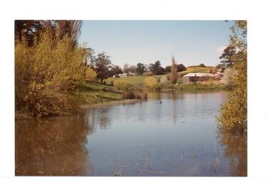
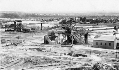
Showing 137 items
matching old dam
-
 Puffing Billy Railway
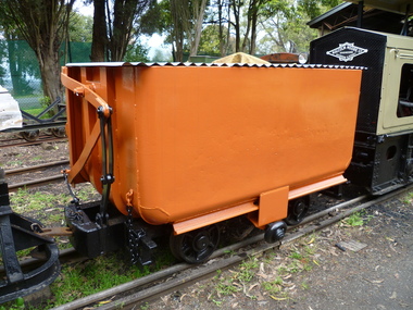
Side Tipping Wagon - W. G. Allen & Sons (Tipton) Ltd
Built by W. G. Allen & Sons (Tipton) Ltd., Tipton, Staffordshire, England. This vehicle was used on the construction of dams, etc., and the Jindivick tunnel at Tarago in Gippsland for the state Rivers & Water Supply Commission of Victoria. The small wheel located on the side ran up a suitably located ramp automatically tipping the hopper and emptying the contents. Historic - Industrial Narrow Gauge Railway - side tipping wagon used by the State Rivers & Water Supply Commission of Victoria - Jindivick tunnel at Tarago, Victoria, AustraliaSide Tipping Wagon made of Iron, steel and wrought ironpuffing billy railway, pbr, side tipping wagon - w. g. allen & sons (tipton) ltd, puffing billy, side tipping wagon, w. g. allen & sons (tipton) ltd, jindivick tunnel, state rivers & water supply commission of victoria -
 El Dorado Museum Association Inc.
Photograph (item) - Digital Image
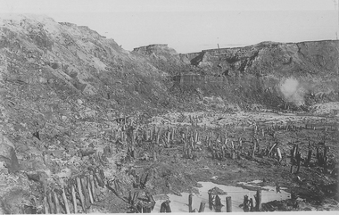
Cocks Pioneer old mine timbers. Cocks Pioneer Electric Gold & Tin Mine Company was formed in 1899. The company's first power station, located at the eastern end of the valley began operating with its 340 Kilowatt steam-powered generator. By 1909, from 2,500,000 cubic yards worked, reported recovery was 17,284 ounces of gold and 224 tons of tin ore. By 1909, Cocks Pioneer’s power plant had become inadequate and uneconomical. The barge was floated downstream about a mile, but lost time caused the operations to cease. Following testing, a new mine was established by diverting Reid's Creek at a cost of £25 000. Settling dams were built, one of which held 1,935,900 cubic feet. Sold earth banks, built against a wall of stringy bark saplings constructed and laced with vertical props, were built. In 1914, the company was reformed as Cock’s Pioneer Gold and Tin Mines NL, another power station was constructed at the western end of the township, near the junction of Clear and Reid's Creeks. From 6,800,000 cubic yards of material processed, the returns were 64,397 ounces of gold and 855 ton of tin. Cocks Pioneer mine then moved the barge downs stream and continued sluicing. In 1929 Cocks Pioneer Electric Gold and Tin Mining Company ceased operations due to a drop in values. Cock’s Pioneer Gold and Tin Mines NL carried on large-scale hydraulic sluicing operations until 1941. mining, gold, tin, open cut, gold mining, tin mining, cocks pioneer, el dorado, eldorado -
 Tatura Irrigation & Wartime Camps Museum
Book, Lake Eildon - A Record low, 2000
To record and compare water levels and to showcase the success of "Eildon Lake Charters" in Murrindindi Tourism Competition "Best New Business 2000". Book includes many old historic preflooding photos.Clear plastic dust cover. White front cover with photograph of Eildon and Sugarloaf Dam in foreground. Insert of charter boat.buesiness, flooding, boat club, books, history, local -
Stawell Historical Society Inc
Headwear - Portrait, Bro Edmund Gray, 1908
Mr Edward Gray An old Pioneer - Miner Born Aberdeen Scotland 1839 Died Stawell 21/9/1908 Accidently Drowned in Moonlight Dam One of the founders of M.U.I.O.O.F. Lodge Grand Master of Masonic LodgeCopy of photograph of man in suit. Head and shoulders.In Memory of Bro E. Gray. P.S.W Died Sept 21 1908 -
 Ballarat Heritage Services
digital photographs, Lisa Gervasoni, Pre-Olympic Swimming Pool at Kilmore, c2012, c2010-2017
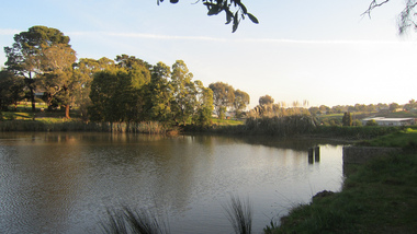
There are many reports of early swimming holes in 19th Century Victoria. Between the period 1895 - 1920, most rural Councils were under pressure to provide more formalised bathing arrangements. Often this occurred through the building of wooden enclosures in rivers, the damming of creeks, the construction of lakes, or the utilisation of old pits for the purpose.Colour photograph of the site of the former Kilmore Pool, now a reservoir on the Kilmore Golf Club. swimming pool, sport, swimming, pre olympic, natural, lake, kilmore, pre-olympic -
 Bendigo Historical Society Inc.
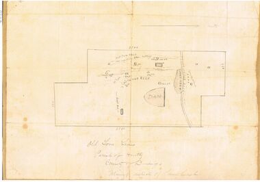
Map - OLD TOM MINE, WHIPSTICK
2 copies ( A4 and A3) of Old Tom lease. Map shows Old Tom Reef, old working open cutting, shaft 150 ft., Easter Reef, dam sand heap, water race, 3 other shafts, 120ft., 90ft., and 500 ft. marked on map. Stamped on map '64.3.34' Written on bottom of map in handwriting ' Old Tom Lease, Parish of Huntly, County of Bendigo, Mining district of Sandhurst'bendigo, mining, old tom lease map -
 Buninyong & District Historical Society
Photograph - Original B/W Photograph, View over the Gong towards the Buninyong Gardens, with established trees and early model motor vehicles
The photograph, taken c 1940 show The Gong and the view to the Buninyong Gardens. The trees in the Gardens are well established and early model motor vehicles are seen parked on the Gong dam wall. The Gong and the Buninyong Botanic Gardens are iconic features of the town. They are of great historic, aesthetic and social significance. They are representative of early parklands.Original B/W photograph of the view over the Gong towards the Buninyong Gardens, with established trees and early model motor vehiclesthe gong, buninyong, gardens, botanic gardens, cars, parklands -
 Buninyong & District Historical Society
Photograph - Original Colour Photograph, Clive Brooks, View of The Gong, looking South East, 1982
Record of Gong 1980's.Colour photo, view looking S.E. of the Upper Dam, also known as The Gong,. Buildings, upper left hoiuse of T. Attwood, Market Gardener, 1860; Centre bluestone former brewery 1854 and behind extension 1980.gong, reservour, brewery, attwood -
 Stawell Historical Society Inc
Photograph, Sloane's & Scotchman United Mining Co in Stawell looking North West with Poppet Heads & Sheds 1914 -- Photo & Colured Painting
Poppet Heads, Ore bin Winding Engine Shed Sloane's & Scotchmans United Quartz Mining Co looking North West Moonlight dams in background. Mine on left is the old Extended mine where the winding engine shed has been destroyed by fire. Just behind that is the Winding Engine Shed of the Oriental Mine without the poppet head.View of two mine sites with poppet heads and engine sheds. Settling dams in background.mining, panorama -
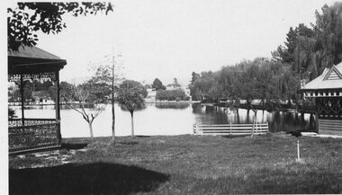 Stawell Historical Society Inc
Photograph - Valentine Series No. 1082 Lake Victoria Park, Stawell, Victoria Park Stawell with two Rotundas one cast iron and one wood (Now Cato Park)
Valentine Series Postcard. Victoria Park later Cato Park at Head of the St George Mine Dam originally established with donations from Mr E Simmons and voluntary efforts. Shows two rotundas.B/W Photo. Valentine Series No. 1082 Lake Victoria Park, Stawell. Taken between the two rotundas showing lake, pier and older willows. Both now renamed Cato lake and Cato park.Valentines Real Photo Series Logo. Published by the Valentine Publishing Co. Pty. Ltd. Queen St. Melb.stawell -
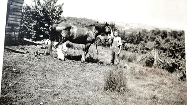
 Wonga Park Community Cottage History Group
Photograph (sub-item) - Black and White, Cleaning out the dam on Heims’ property in 1930’s – view up hill towards Jumping Creek Road
-
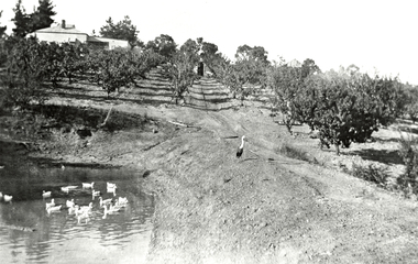 Wonga Park Community Cottage History Group
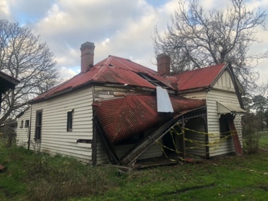
Photograph (Item) - Black and White, Wonga Park: Read's Dam, Orchard and House, c. 1931
Wonga Park: Read's Dam, Orchard and HousePhoto is named 14880016.jpg on CD -
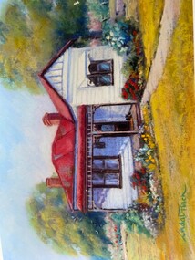 Wonga Park Community Cottage History Group
Photograph - Painting, The Hedge, Yarra Road Wonga Park
The Hedge, aka Thomas Knee's house. Thomas Samuel Knee (born c. 1881in Lilydale) married Jane Maggs c. 1912, Thomas Samuel Knee's father Thomas Knee (married to Sarah Hardidge and who it appears was also an orchardist in Yarra Road) was rated for the land as vacant land at the turn of the century (c. 1900) Thomas Samuel Knee rated as owner of vacant land (CA14B of over 20 acres1911-12 and as a house 1912-13, next year CA 14C added making a total of 39 acres. It appears that Thomas Samuel Knee and his wife Jane lived at the property until 1949 when they moved to Montrose. In 1949 it was purchased by Hubert Victor (Vic) Eggleton after they migrated from Banstead in Surrey England. They had four boys Peter (who did a lot of the farming with Gladys), Brian, Michael and Roger. It was mixed farming: lemons, cherries, eggs, chickens and Gladys bred Spaniel dogs too. They had 2 dairy cows and a draft horse. The farm was larger then and was subdivided at a later date. The big dam was added too. the painting of the house was painted by a cousin of the Lusks. Ownership: Thomas Samuel Knee 1912-1949, Eggletons, 1949 - c.1953, then Timms, c. 1953 - early 1970s then Lusks early 1970s to c. 2012. The Lusks built a new house and after that the old house had various tenants. -
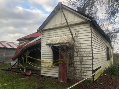 Wonga Park Community Cottage History Group
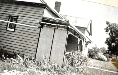
Photograph - Colour, The Hedge (Tom Knee's House) 278 Yarra Road Wonga Park in 2023
The Hedge, aka Thomas Knee's house. Thomas Samuel Knee (born c. 1881in Lilydale) married Jane Maggs c. 1912, Thomas Samuel Knee's father Thomas Knee (married to Sarah Hardidge and who it appears was also an orchardist in Yarra Road) was rated for the land as vacant land at the turn of the century (c. 1900) Thomas Samuel Knee rated as owner of vacant land (CA14B of over 20 acres1911-12 and as a house 1912-13, next year CA 14C added making a total of 39 acres. It appears that Thomas Samuel Knee and his wife Jane lived at the property until 1949 when they moved to Montrose. In 1949 it was purchased by Hubert Victor (Vic) Eggleton after they migrated from Banstead in Surrey England. They had four boys Peter (who did a lot of the farming with Gladys), Brian, Michael and Roger. It was mixed farming: lemons, cherries, eggs, chickens and Gladys bred Spaniel dogs too. They had 2 dairy cows and a draft horse. The farm was larger then and was subdivided at a later date. The big dam was added too. the painting of the house was painted by a cousin of the Lusks. Ownership: Thomas Samuel Knee 1912-1949, Eggletons, 1949 - c.1953, then Timms, c. 1953 - early 1970s then Lusks early 1970s to c. 2012. The Lusks built a new house and after that the old house had various tenants. -
 Wonga Park Community Cottage History Group
Photograph - Black and White, The Hedge (Tom Knee's House) 278 Yarra Road Wonga Park in 1949
The Hedge, aka Thomas Knee's house. Thomas Samuel Knee (born c. 1881in Lilydale) married Jane Maggs c. 1912, Thomas Samuel Knee's father Thomas Knee (married to Sarah Hardidge and who it appears was also an orchardist in Yarra Road) was rated for the land as vacant land at the turn of the century (c. 1900) Thomas Samuel Knee rated as owner of vacant land (CA14B of over 20 acres1911-12 and as a house 1912-13, next year CA 14C added making a total of 39 acres. It appears that Thomas Samuel Knee and his wife Jane lived at the property until 1949 when they moved to Montrose. In 1949 it was purchased by Hubert Victor (Vic) Eggleton after they migrated from Banstead in Surrey England. They had four boys Peter (who did a lot of the farming with Gladys), Brian, Michael and Roger. It was mixed farming: lemons, cherries, eggs, chickens and Gladys bred Spaniel dogs too. They had 2 dairy cows and a draft horse. The farm was larger then and was subdivided at a later date. The big dam was added too. the painting of the house was painted by a cousin of the Lusks. Ownership: Thomas Samuel Knee 1912-1949, Eggletons, 1949 - c.1953, then Timms, c. 1953 - early 1970s then Lusks early 1970s to c. 2012. The Lusks built a new house and after that the old house had various tenants. -
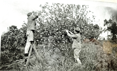
 Wonga Park Community Cottage History Group
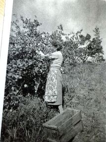
Photograph - Black and White, Wonga Park: Gladys Eggleton picking lemons between 1949 and 1953
The Hedge, aka Thomas Knee's house. Thomas Samuel Knee (born c. 1881in Lilydale) married Jane Maggs c. 1912, Thomas Samuel Knee's father Thomas Knee (married to Sarah Hardidge and who it appears was also an orchardist in Yarra Road) was rated for the land as vacant land at the turn of the century (c. 1900) Thomas Samuel Knee rated as owner of vacant land (CA14B of over 20 acres1911-12 and as a house 1912-13, next year CA 14C added making a total of 39 acres. It appears that Thomas Samuel Knee and his wife Jane lived at the property until 1949 when they moved to Montrose. In 1949 it was purchased by Hubert Victor (Vic) Eggleton after they migrated from Banstead in Surrey England. They had four boys Peter (who did a lot of the farming with Gladys), Brian, Michael and Roger. It was mixed farming: lemons, cherries, eggs, chickens and Gladys bred Spaniel dogs too. They had 2 dairy cows and a draft horse. The farm was larger then and was subdivided at a later date. The big dam was added too. the painting of the house was painted by a cousin of the Lusks. Ownership: Thomas Samuel Knee 1912-1949, Eggletons, 1949 - c.1953, then Timms, c. 1953 - early 1970s then Lusks early 1970s to c. 2012. The Lusks built a new house and after that the old house had various tenants. -
 Wonga Park Community Cottage History Group
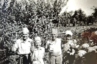
Photograph - Black and White, Wonga Park: Eggleton family's first Christmas in Australia 1949
The Hedge, aka Thomas Knee's house. Thomas Samuel Knee (born c. 1881in Lilydale) married Jane Maggs c. 1912, Thomas Samuel Knee's father Thomas Knee (married to Sarah Hardidge and who it appears was also an orchardist in Yarra Road) was rated for the land as vacant land at the turn of the century (c. 1900) Thomas Samuel Knee rated as owner of vacant land (CA14B of over 20 acres1911-12 and as a house 1912-13, next year CA 14C added making a total of 39 acres. It appears that Thomas Samuel Knee and his wife Jane lived at the property until 1949 when they moved to Montrose. In 1949 it was purchased by Hubert Victor (Vic) Eggleton after they migrated from Banstead in Surrey England. They had four boys Peter (who did a lot of the farming with Gladys), Brian, Michael and Roger. It was mixed farming: lemons, cherries, eggs, chickens and Gladys bred Spaniel dogs too. They had 2 dairy cows and a draft horse. The farm was larger then and was subdivided at a later date. The big dam was added too. the painting of the house was painted by a cousin of the Lusks. Ownership: Thomas Samuel Knee 1912-1949, Eggletons, 1949 - c.1953, then Timms, c. 1953 - early 1970s then Lusks early 1970s to c. 2012. The Lusks built a new house and after that the old house had various tenants. -
 Wonga Park Community Cottage History Group
Photograph - Black and White, Wonga Park: Peter Eggleton with Captain, a draught horse between 1949 and 1953
The Hedge, aka Thomas Knee's house. Thomas Samuel Knee (born c. 1881in Lilydale) married Jane Maggs c. 1912, Thomas Samuel Knee's father Thomas Knee (married to Sarah Hardidge and who it appears was also an orchardist in Yarra Road) was rated for the land as vacant land at the turn of the century (c. 1900) Thomas Samuel Knee rated as owner of vacant land (CA14B of over 20 acres1911-12 and as a house 1912-13, next year CA 14C added making a total of 39 acres. It appears that Thomas Samuel Knee and his wife Jane lived at the property until 1949 when they moved to Montrose. In 1949 it was purchased by Hubert Victor (Vic) Eggleton after they migrated from Banstead in Surrey England. They had four boys Peter (who did a lot of the farming with Gladys), Brian, Michael and Roger. It was mixed farming: lemons, cherries, eggs, chickens and Gladys bred Spaniel dogs too. They had 2 dairy cows and a draft horse. The farm was larger then and was subdivided at a later date. The big dam was added too. the painting of the house was painted by a cousin of the Lusks. Ownership: Thomas Samuel Knee 1912-1949, Eggletons, 1949 - c.1953, then Timms, c. 1953 - early 1970s then Lusks early 1970s to c. 2012. The Lusks built a new house and after that the old house had various tenants. -
 Wonga Park Community Cottage History Group
Photograph - Black and White, Wonga Park: Brian and Roger Eggleton picking lemons between 1949 and 1953
The Hedge, aka Thomas Knee's house. Thomas Samuel Knee (born c. 1881in Lilydale) married Jane Maggs c. 1912, Thomas Samuel Knee's father Thomas Knee (married to Sarah Hardidge and who it appears was also an orchardist in Yarra Road) was rated for the land as vacant land at the turn of the century (c. 1900) Thomas Samuel Knee rated as owner of vacant land (CA14B of over 20 acres1911-12 and as a house 1912-13, next year CA 14C added making a total of 39 acres. It appears that Thomas Samuel Knee and his wife Jane lived at the property until 1949 when they moved to Montrose. In 1949 it was purchased by Hubert Victor (Vic) Eggleton after they migrated from Banstead in Surrey England. They had four boys Peter (who did a lot of the farming with Gladys), Brian, Michael and Roger. It was mixed farming: lemons, cherries, eggs, chickens and Gladys bred Spaniel dogs too. They had 2 dairy cows and a draft horse. The farm was larger then and was subdivided at a later date. The big dam was added too. the painting of the house was painted by a cousin of the Lusks. Ownership: Thomas Samuel Knee 1912-1949, Eggletons, 1949 - c.1953, then Timms, c. 1953 - early 1970s then Lusks early 1970s to c. 2012. The Lusks built a new house and after that the old house had various tenants. -
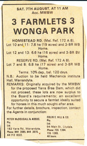 Wonga Park Community Cottage History Group
Work on paper - Newspaper cutting, Wonga Park: Date unknown, Paper unknown: Advertisement by MMBW for sale of 3 Farmlets no longer required for Yarra Brae Dam which did not proceed
-
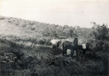
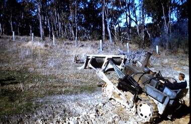 Wonga Park Community Cottage History Group
photograph, dam making, c 1940 for 1003 c1960 for 1003-1
Ernie Kear and his son Bruce were local excavators and involved in many projects around Wonga Park requiring bull dozing, in particular clearing land for orchards, building dams etcEarly history of Wonga Park orchard growing district. Early dams were built by horse and scoop on the back which was handled by the orchardist, or the dam builder but later replaced by bulldozersErnie Kear excavating a dam in Wonga Park c 1940 no hard copy electronic only -
 Wodonga & District Historical Society Inc
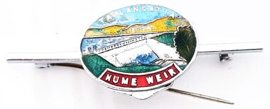
Souvenir - Tallangatta - Hume Weir Tiepin, 1980s
A wide range of items have been created as souvenirs to represent the Hume Weir on the Murray River. Work on Hume Dam started in 1919 and took 17 years to complete. Souvenir items have included chinaware, ashtrays, placemats and small jewellery items such as this tie pin. This tie pin was created as a souvenir for the town of Tallangatta. In the 1950s, the height of the Hume Weir wall was increased, resulting in a nine metre rise in the level of the water in Lake Hume. This necessitated the moving of most of the town of Old Tallangatta due to flooding. The transfer of the township by the State Rivers and Waters Supply Commission to a new site approximately 8 kilometres to the west was completed on 29 June 1956.This item is representative of many items commemorating the Hume Weir and the township of Tallangatta.A small metal and enamelled oval tie pin. It features and image of the Hume Weir.Around top edge in white: TALLANGATTA Around bottom edge" HUME WEIR"hume weir australia, tallangatta, tallangatta - the town that moved -
 Wodonga & District Historical Society Inc
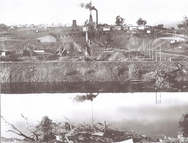
Album - Hume Reservoir Australia Album - View from the Victorian bank of the Murray River, May 1923
This set of photos is from a leather bound album bearing the inscription "HUME RESERVOIR AUSTRALIA" plus 'The Rt. Hon. L. C. M. S. Amery, P. C., M .P.' all inscribed in gold. It was presented to The Rt. Hon. L. C. M. S. Amery, P. C., M. P, Secretary of State for Dominion Affairs on the occasion of his visit to the Hume Reservoir on 2nd November 1927. This album is of local and national significance as it documents the planning and development of the Hume Reservoir up to 1927. It was the largest water reservoir in the British Empire. The album records the pioneering engineering work that went into its construction.DEPARTMENT OF PUBLIC WORKS, N.S.W. RIVER MURRAY WATERS SCHEME. HUME RESERVOIR. 12. View from the Victorian bank of the river showing in the foreground a levee bank along the New South Wales side of the river with connecting wings back to the higher ground, May 1923. The first stage in the construction of the Dam foundations was carried out inside the levee bank which was at a sufficient height to protect from floods the work going on inside. A length of 300 feet of the Dam was left at a low elevation to allow of the river flowing over it in the second stage of the operations and at the ends of the concrete was brought up above flood level. To divert the river, a Coffer Dam was built across the old bed above and below the Dam site and tying into the end of the concrete wall built inside the levee bank. This completely surrounded the remainder of the site of the Dam and south wing wall, including an area of 12½ acres.hume reservoir australia, river murray waters scheme, hume reservoir construction -
 Wodonga & District Historical Society Inc
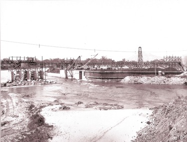
Album - Hume Reservoir Australia Album - Driving first row of piles for coffer dam across the river, December 1925
This set of photos is from a leather bound album bearing the inscription "HUME RESERVOIR AUSTRALIA" plus 'The Rt. Hon. L. C. M. S. Amery, P. C., M .P.' all inscribed in gold. It was presented to The Rt. Hon. L. C. M. S. Amery, P. C., M. P, Secretary of State for Dominion Affairs on the occasion of his visit to the Hume Reservoir on 2nd November 1927. This album is of local and national significance as it documents the planning and development of the Hume Reservoir up to 1927. It was the largest water reservoir in the British Empire. The album records the pioneering engineering work that went into its construction.DEPARTMENT OF PUBLIC WORKS, N.S.W. RIVER MURRAY WATERS SCHEME. HUME RESERVOIR. 19. Driving first row of piles for coffer dam across the river. New South Wales. December 1925. Cofferdams are temporary structures used where construction is being carried out in areas submerged in water. They are most commonly used to facilitate the construction or repair of dams, piers and bridges. To divert the river, a Coffer Dam was built across the old bed above and below the Dam site and tying into the end of the concrete wall built inside the levee bank. This completely surrounded the remainder of the site of the Dam and south wing wall, including an area of 12½ acres. hume reservoir australia, river murray waters scheme, hume reservoir construction -
 Wodonga & District Historical Society Inc
Album - Hume Reservoir Australia Album - Section of completed coffer dam, January 1927
This set of photos is from a leather bound album bearing the inscription "HUME RESERVOIR AUSTRALIA" plus 'The Rt. Hon. L. C. M. S. Amery, P. C., M .P.' all inscribed in gold. It was presented to The Rt. Hon. L. C. M. S. Amery, P. C., M. P, Secretary of State for Dominion Affairs on the occasion of his visit to the Hume Reservoir on 2nd November 1927. This album is of local and national significance as it documents the planning and development of the Hume Reservoir up to 1927. It was the largest water reservoir in the British Empire. The album records the pioneering engineering work that went into its construction.DEPARTMENT OF PUBLIC WORKS, N.S.W. RIVER MURRAY WATERS SCHEME. HUME RESERVOIR. 20. Section of completed coffer dam with river diverted over the concrete foundations of dam that were placed during the first stage of operations. New South Wales. January 1927. Cofferdams are temporary structures used where construction is being carried out in areas submerged in water. They are most commonly used to facilitate the construction or repair of dams, piers and bridges. To divert the river, a Coffer Dam was built across the old bed above and below the Dam site and tying into the end of the concrete wall built inside the levee bank. This completely surrounded the remainder of the site of the Dam and south wing wall, including an area of 12½ acres. hume reservoir australia, river murray waters scheme, hume reservoir construction -
 Wodonga & District Historical Society Inc
Album - Hume Reservoir Australia Album - Excavations for foundations inside coffer dam, January 1927
This set of photos is from a leather bound album bearing the inscription "HUME RESERVOIR AUSTRALIA" plus 'The Rt. Hon. L. C. M. S. Amery, P. C., M .P.' all inscribed in gold. It was presented to The Rt. Hon. L. C. M. S. Amery, P. C., M. P, Secretary of State for Dominion Affairs on the occasion of his visit to the Hume Reservoir on 2nd November 1927. This album is of local and national significance as it documents the planning and development of the Hume Reservoir up to 1927. It was the largest water reservoir in the British Empire. The album records the pioneering engineering work that went into its construction.DEPARTMENT OF PUBLIC WORKS, N.S.W. RIVER MURRAY WATERS SCHEME. HUME RESERVOIR. 21. Excavations for foundations inside coffer dam. New South Wales. January 1927. Cofferdams are temporary structures used where construction is being carried out in areas submerged in water. They are most commonly used to facilitate the construction or repair of dams, piers and bridges. To divert the river, a Coffer Dam was built across the old bed above and below the Dam site and tying into the end of the concrete wall built inside the levee bank. This completely surrounded the remainder of the site of the Dam and south wing wall, including an area of 12½ acres. hume reservoir australia, river murray waters scheme, hume reservoir construction, coffer dam -
 Wodonga & District Historical Society Inc
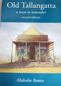
Book - Old Tallangatta : A town to remember 1850 - 1950, Malcolm Ronan, 2003
... to the expansion of the Hume Dam Old Tallangatta : A town to remember 1850 ...A history of the township of Tallangatta, Victoria which was moved in the 1950s due to the expansion of the Hume Damnon-fictionA history of the township of Tallangatta, Victoria which was moved in the 1950s due to the expansion of the Hume Damold tallangatta, tallangatta, hume dam, "the town that moved" -
 Victorian Harness Racing Heritage Collection at Lord's Raceway Bendigo
Clothing - Race Colours, Bryan Healy
The race colours of the Hall of Fame trotter Maoris Idol. Trained at Marnoo in Victoria's Wimmera by Rick Healy, and driven in all his races by his son Bryan. Maori's Idol (September 1972 – 20 October 2006) was an Australian Standardbred racehorse. He was the first Australian trotter to break two minutes with a time of 1:59.3 on 19 November 1977 at Moonee Valley. Maori's Idol became one of Australia's greatest trotters, with a record 24 successive race victories before placing third in the 1978 Melbourne Inter-Dominion Final. He is still the trotting record holder with 22 wins in a season.He was so superior to his rivals that he may have gone through his career unbeaten had he been placed to advantage by his connections. He was by Ike Frost US (by Adios) his dam was Maori Miss by Grand Monarch. Maori Miss won a heat of the 1966 Inter DominionTrotting Championship and was selected as the Australian Broodmare of the Year in 1977, 1978 and 1979. Maori's Idol older half-brother Maori Monarch won the Victoria Trotters Derby and the Australasian Trotting Championship. Maori Miss has founded a very successful family of her own and is the third dam of Sumthingaboutmaori.bryan healy, ric healy, r healy, maori's idol, bendigo harness racing club, bhrc, bendigo, horses, race colours, trophies, trotting, pacing, harness racing, br healy, b healy, r mcd healy -
 Federation University Historical Collection
Map, Ballarat Goldfield, c1898
This map shows geological features, suggests the last basalt flow, and includes alotments and names of Mining Companies. Although this map has no date on it the Ballarat Industrial School is used for dating purposed. The Ballarat Industrial School ran from 1869-1879, but the term Ballarat Industrial School Reserve was still in use in 1898 and possibly beyond.Geological Map of Ballarat with 3 holes in the left hand side. The map indicates the position of Lake Wendouree, Township of Warrenheip, Ballarat East, Industrial School Reserve, Winters Swamp, Police Paddock, Wyndholm Premptive Right (Salton and Waldie), Black Hill, Vale Park Reserve, Pennyweight Hill, Little Bendigo, Black Swamp Lead, monte Christo Reef, Chinaman's Gully, Miners Rest, Pincotts Dam, Northumberland Gully. It also show the following goldmining companies: City of Ballarat, Kohinor, Hand and Band, Great North West, Northern Junction, Kneeshaw, Rossers Freehold, Silurial.ballarat, warrenheip, lake wendouree, ballarat east, winters swamp, winter swamp, wyndholm premptive right, cemetery, vale park reserve, little bendigo, kneeshaw co., industrial school reserve, kirks dam, pincotts dam, black hill, wombat hill, dead horse gully, miners rest, mt rowan, salton and waldie, rose hill co, great north west no 1, rose's freehold co, hand and band co, police reserve, police paddock, mount rowan, ballarat industrial school reserve, market reserve, winter's swamp, kneeshar co, monte cristo line of reef, chinaman's gully or black snake, milkmaid's gully, ballarat gold field, bakery hil lead, old gravel pits lead, golden point lead, eureka lead, miner's rest, yarrowee creek, leigh creek, black swamp lead, yorkshire reef, nil desperandum reef, cockatoo lead, hit or miss gully, herbert werner frederick de nully, pennyweight hill, esmond's lead, ash's lead, nightingale lead, john bull gully, gladstone reef, whitehorse reef, petticoat creek, pincott's dam, frenchman's gully, tim's crushing plant, jenkin's gully, california gully, drake's creek, sulton and waldie, ballarat undustrial school, ballarat & mariborough railway