Showing 121 items
matching pioneer section
-
 Wodonga & District Historical Society Inc
Album - Hume Reservoir Australia Album - Hume Reservoir Detailed diagrams, Department of Public Works, N.S.W, 1927
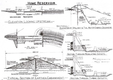
This set of photos is from a leather bound album bearing the inscription "HUME RESERVOIR AUSTRALIA" plus 'The Rt. Hon. L. C. M. S. Amery, P. C., M .P.' all inscribed in gold. It was presented to The Rt. Hon. L. C. M. S. Amery, P. C., M. P, Secretary of State for Dominion Affairs on the occasion of his visit to the Hume Reservoir on 2nd November 1927. This album is of local and national significance as it documents the planning and development of the Hume Reservoir up to 1927. It was the largest water reservoir in the British Empire. The album records the pioneering engineering work that went into its construction.6 Diagrams showing the details of the Hume Reservoir structure. On the left from the top of the page to bottom are:- ELEVATION LOOKING UPSTREAM, PLAN aTYPICAL SECTION OF EARTHEN EMBANKMENT. ' On the right from top to bottom are:- SECTIONAL - ELEVATION OF SPILLWAY & TAIL WATER ENERGY DISSIPATOR, SECTION THROUGH REGULATING OUTLETS and SECTION THROUGH TURBINE OUTLETS.hume reservoir australia, river murray waters scheme, hume weir diagrams, hume plan details -
 Wodonga & District Historical Society Inc
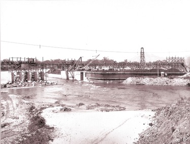
Album - Hume Reservoir Australia Album - Excavations for foundations of spillway, September 1921
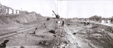
This set of photos is from a leather bound album bearing the inscription "HUME RESERVOIR AUSTRALIA" plus 'The Rt. Hon. L. C. M. S. Amery, P. C., M .P.' all inscribed in gold. It was presented to The Rt. Hon. L. C. M. S. Amery, P. C., M. P, Secretary of State for Dominion Affairs on the occasion of his visit to the Hume Reservoir on 2nd November 1927. This album is of local and national significance as it documents the planning and development of the Hume Reservoir up to 1927. It was the largest water reservoir in the British Empire. The album records the pioneering engineering work that went into its construction.DEPARTMENT OF PUBLIC WORKS, N.S.W. RIVER MURRAY WATERS SCHEME. HUME RESERVOIR. 6. Excavation in progress for foundations of outlet and spillway sections of dam. September 1921.hume reservoir australia, river murray waters scheme, hume weir diagrams, hume plan details -
 Wodonga & District Historical Society Inc
Album - Hume Reservoir Australia Album - General view of earth embankment in Victoria, October 1924
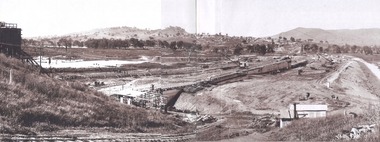
This set of photos is from a leather bound album bearing the inscription "HUME RESERVOIR AUSTRALIA" plus 'The Rt. Hon. L. C. M. S. Amery, P. C., M .P.' all inscribed in gold. It was presented to The Rt. Hon. L. C. M. S. Amery, P. C., M. P, Secretary of State for Dominion Affairs on the occasion of his visit to the Hume Reservoir on 2nd November 1927. This album is of local and national significance as it documents the planning and development of the Hume Reservoir up to 1927. It was the largest water reservoir in the British Empire. The album records the pioneering engineering work that went into its construction.DEPARTMENT OF PUBLIC WORKS, N.S.W. RIVER MURRAY WATERS SCHEME. HUME RESERVOIR. 17. General view of earth embankment in Victoria. New South Wales section of work and Township beyond. October 1924.hume reservoir australia, river murray waters scheme, hume reservoir construction -
 Wodonga & District Historical Society Inc
Album - Hume Reservoir Australia Album - Stilling pool opposite outlet section of dam, December 1925
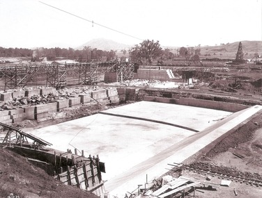
This set of photos is from a leather bound album bearing the inscription "HUME RESERVOIR AUSTRALIA" plus 'The Rt. Hon. L. C. M. S. Amery, P. C., M .P.' all inscribed in gold. It was presented to The Rt. Hon. L. C. M. S. Amery, P. C., M. P, Secretary of State for Dominion Affairs on the occasion of his visit to the Hume Reservoir on 2nd November 1927. This album is of local and national significance as it documents the planning and development of the Hume Reservoir up to 1927. It was the largest water reservoir in the British Empire. The album records the pioneering engineering work that went into its construction.DEPARTMENT OF PUBLIC WORKS, N.S.W. RIVER MURRAY WATERS SCHEME. HUME RESERVOIR. 18. Stilling pool opposite outlet section of dam. New South Wales. December 1925 A stilling pool is a structure at the downstream side of a dam, designed to take away some of the energy from overtopping water flowing down the spillway, to reduce the risk of erosion of the ground near the dam and the dam itself.hume reservoir australia, river murray waters scheme, hume reservoir construction -
 Wodonga & District Historical Society Inc
Album - Hume Reservoir Australia Album - Section of completed coffer dam, January 1927
This set of photos is from a leather bound album bearing the inscription "HUME RESERVOIR AUSTRALIA" plus 'The Rt. Hon. L. C. M. S. Amery, P. C., M .P.' all inscribed in gold. It was presented to The Rt. Hon. L. C. M. S. Amery, P. C., M. P, Secretary of State for Dominion Affairs on the occasion of his visit to the Hume Reservoir on 2nd November 1927. This album is of local and national significance as it documents the planning and development of the Hume Reservoir up to 1927. It was the largest water reservoir in the British Empire. The album records the pioneering engineering work that went into its construction.DEPARTMENT OF PUBLIC WORKS, N.S.W. RIVER MURRAY WATERS SCHEME. HUME RESERVOIR. 20. Section of completed coffer dam with river diverted over the concrete foundations of dam that were placed during the first stage of operations. New South Wales. January 1927. Cofferdams are temporary structures used where construction is being carried out in areas submerged in water. They are most commonly used to facilitate the construction or repair of dams, piers and bridges. To divert the river, a Coffer Dam was built across the old bed above and below the Dam site and tying into the end of the concrete wall built inside the levee bank. This completely surrounded the remainder of the site of the Dam and south wing wall, including an area of 12½ acres. hume reservoir australia, river murray waters scheme, hume reservoir construction -
 Wodonga & District Historical Society Inc
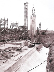
Album - Hume Reservoir Australia Album - Work proceeding inside the coffer dam, August 1927
This set of photos is from a leather bound album bearing the inscription "HUME RESERVOIR AUSTRALIA" plus 'The Rt. Hon. L. C. M. S. Amery, P. C., M .P.' all inscribed in gold. It was presented to The Rt. Hon. L. C. M. S. Amery, P. C., M. P, Secretary of State for Dominion Affairs on the occasion of his visit to the Hume Reservoir on 2nd November 1927. This album is of local and national significance as it documents the planning and development of the Hume Reservoir up to 1927. It was the largest water reservoir in the British Empire. The album records the pioneering engineering work that went into its construction.DEPARTMENT OF PUBLIC WORKS, N.S.W. RIVER MURRAY WATERS SCHEME. HUME RESERVOIR. 25. Work proceeding inside the Coffer Dam. This shows the curving downstream face of the Spillway section taking shape, the bottom edge being the line of the contraction joint between the wall and the energy dissipater which has still to be built. Note the steam navvy at the end of the bit of curved work ready to take out the foundations for the energy dissipater. The tall concrete pillar is a portion of the work at the intersection of the main and south wing walls which was built in advance of the rest of the work to accommodate the tail tower of the cableway. The Tail Tower for the first stages of the work stood on the ground. Part of it is seen erected on the pillar while part of it is still in its original position. To command the concreting of the pillar end of the south wing wall a twin hoist tower of steel construction was erected at the end of the belt conveyor. This hoist is 160 feet high. The belt conveyor will at a later stage be raised for the concreting of the upper portion of the dam and the trestles are now being built up for that purpose. A drag line excavator with a 2 cubic yard capacity bucket is at work near the tail tower on the foundations for the south wing wall. New South Wales, August 1927.hume reservoir australia, river murray waters scheme, hume reservoir construction -
 Wodonga & District Historical Society Inc
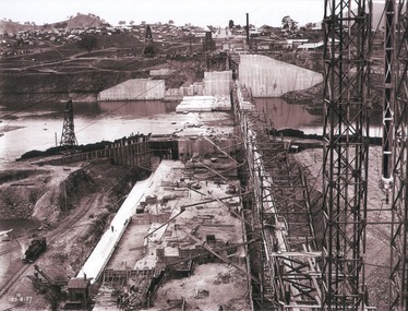
Album - Hume Reservoir Australia Album - View of concrete dam from top of tall tower pillar, August 1927
This set of photos is from a leather bound album bearing the inscription "HUME RESERVOIR AUSTRALIA" plus 'The Rt. Hon. L. C. M. S. Amery, P. C., M .P.' all inscribed in gold. It was presented to The Rt. Hon. L. C. M. S. Amery, P. C., M. P, Secretary of State for Dominion Affairs on the occasion of his visit to the Hume Reservoir on 2nd November 1927. This album is of local and national significance as it documents the planning and development of the Hume Reservoir up to 1927. It was the largest water reservoir in the British Empire. The album records the pioneering engineering work that went into its construction.DEPARTMENT OF PUBLIC WORKS, N.S.W. RIVER MURRAY WATERS SCHEME. HUME RESERVOIR. 29. View from Top of Tail Tower Pillar - Concrete Dam. This was taken from the top of the Tower described in the preceding photograph looking towards New South Wales. (WHS 00722) First is the part of the spillway being built inside the Coffer Dam, then over the Coffer Dam the submerged portion of the Spillway and outlet sections for the river diversion, beyond that the situation for the hydro-electric turbo passages bounded by the North Wing Wall. The gap may be seen in wing wall for the passage of the belt conveyor and half of the concrete mixer house behind. This gives a general view of the New South Wales Township. The Quarry is on the side of the hill showing up beyond the Township. New South Wales, August 1927.hume reservoir australia, river murray waters scheme, hume reservoir construction -
 Wodonga & District Historical Society Inc
Book - The Kiewa Valley and Its Pioneers, Esther Temple, 1971
Historical handbook, includes brief section on Kiewa Valley tribes (Ya-itma-thang, Whroo, Kiewa, Unurring & Murramurrangbong), territory, shelters, fire, foods, including bogong moth, weapons, containers for water, fibre making for nets, stone tools, biographical details on Billy Elengeist & Queen Emily of the Murramurrangbong tribe.non-fictionHistorical handbook, includes brief section on Kiewa Valley tribes (Ya-itma-thang, Whroo, Kiewa, Unurring & Murramurrangbong), territory, shelters, fire, foods, including bogong moth, weapons, containers for water, fibre making for nets, stone tools, biographical details on Billy Elengeist & Queen Emily of the Murramurrangbong tribe.history kiewa valley, victorian pioneers, kiewa valley tribes -
 Falls Creek Historical Society
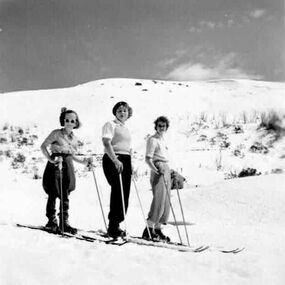
Photograph - Skiers
This photo is part of the Fred Griffith Photographic Collection documenting his time with the Australian Alpine Club and the formation of the Albury Ski Club. Frederick Charles “Fred” Griffith was born in Albury, NSW on 2 March 1910. Educated in Albury and Geelong Grammar. Beginning in 1927 he spent many years working first as a jackeroo and on a range of prominent pastoral and merino stud properties in NSW and Queensland. In 1935 he repurchased his former family property “Toonallook", Bowna, NSW and developed it to be the largest Romney Marsh stud in the world, exporting rams to Argentina. He introduced many innovative practices on his property including rabbit control measures and aerial crop dusting. He was an active member of the Albury Show Society and in 1949 established the Albury Sheep Show. Fred was also the Albury representative on the Graziers’ Association Council for over 30 years. He became a life member of both the Albury and Commercial Clubs. Fred’s greatest hobby was snow skiing. His first visit to the snow was to Kosciusko in 1919. The Albury Ski Club was formed in 1935 and Fred was an inaugural member. In 1949 they were granted a site at Falls Creek to build their own lodge. Fred guaranteed the Club for finance from the Bank of NSW. The first portion of the prefabricated building was constructed in Albury. It was transported to Falls Creek on the back of Fred’s truck and erected in one day. This was the bathroom section and the rest was completed in 1950. The original lodge was burned down in 1952 and a new one built the following year. In 1955, Fred also built the Bowna Lodge for his family in partnership with David Fairbairn. He became head of the North Eastern District Skiing Association (N.E.D.S.A.) and successfully applied to run the Australian Ski Championships. Fred also inaugurated children’s races at Falls Creek and ran them for about 20 years. He also formed the company “Falls Creek Ski Tows”. In 1956 Fred along with a group of key people selected the site for Thredbo Village. Fred and his brother sold Toonallook in sections between 1951 and 1974. He moved to Albury and set up as a landscape gardener and fencing contractor. After a serious work accident, Fred retired in 1985 and moved to Rosebud, Victoria where he died on 19 August 1992.This image records people involved in Falls Creek photographed by a pioneer of the area.2 Black and white images of skiers taken at Bogong.albury ski club, snow sports, falls creek, mount bogong -
 Falls Creek Historical Society
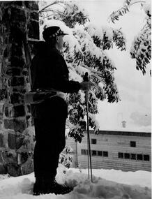
Photograph - Fred Griffith at Bowna, 20 September 1959
Frederick Charles “Fred” Griffith was born in Albury, NSW on 2 March 1910. Educated in Albury and Geelong Grammar. Beginning in 1927 he spent many years working first as a jackeroo and on a range of prominent pastoral and merino stud properties in NSW and Queensland. In 1935 he repurchased his former family property “Toonallook", Bowna, NSW and developed it to be the largest Romney Marsh stud in the world, exporting rams to Argentina. He introduced many innovative practices on his property including rabbit control measures and aerial crop dusting. He was an active member of the Albury Show Society and in 1949 established the Albury Sheep Show. Fred was also the Albury representative on the Graziers’ Association Council for over 30 years. He became a life member of both the Albury and Commercial Clubs. Fred’s greatest hobby was snow skiing. His first visit to the snow was to Kosciusko in 1919. The Albury Ski Club was formed in 1935 and Fred was an inaugural member. In 1949 they were granted a site at Falls Creek to build their own lodge. Fred guaranteed the Club for finance from the Bank of NSW. The first portion of the prefabricated building was constructed in Albury. It was transported to Falls Creek on the back of Fred’s truck and erected in one day. This was the bathroom section and the rest was completed in 1950. The original lodge was burned down in 1952 and a new one built the following year. In 1955, Fred also built the Bowna Lodge for his family in partnership with David Fairbairn. He became head of the North Eastern District Skiing Association (N.E.D.S.A.) and successfully applied to run the Australian Ski Championships. Fred also inaugurated children’s races at Falls Creek and ran them for about 20 years. He also formed the company “Falls Creek Ski Tows”. In 1956 Fred along with a group of key people selected the site for Thredbo Village. Fred and his brother sold Toonallook in sections between 1951 and 1974. He moved to Albury and set up as a landscape gardener and fencing contractor. After a serious work accident, Fred retired in 1985 and moved to Rosebud, Victoria where he died on 19 August 1992. Bowna is now known as the Riverina Ski Club.This image depicts Fred Griffith who was a pioneer of the Albury Ski Club and Falls CreekA black and white photo showing Fred Griffith on left of image looking towards Whitehaven lodge fred griffith, albury ski club, falls creek, bowna ski club -
 Falls Creek Historical Society
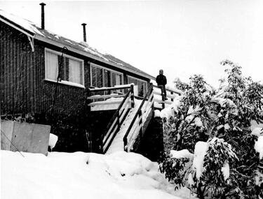
Photograph - Thea Hedley at Bowna Ski Club, 20 September 1959
This photo is part of the Fred Griffith Photographic Collection. Frederick Charles “Fred” Griffith was born in Albury, NSW on 2 March 1910. Educated in Albury and Geelong Grammar. Beginning in 1927 he spent many years working first as a jackeroo and on a range of prominent pastoral and merino stud properties in NSW and Queensland. In 1935 he repurchased his former family property “Toonallook", Bowna, NSW and developed it to be the largest Romney Marsh stud in the world, exporting rams to Argentina. He introduced many innovative practices on his property including rabbit control measures and aerial crop dusting. He was an active member of the Albury Show Society and in 1949 established the Albury Sheep Show. Fred was also the Albury representative on the Graziers’ Association Council for over 30 years. He became a life member of both the Albury and Commercial Clubs. Fred’s greatest hobby was snow skiing. His first visit to the snow was to Kosciusko in 1919. The Albury Ski Club was formed in 1935 and Fred was an inaugural member. In 1949 they were granted a site at Falls Creek to build their own lodge. Fred guaranteed the Club for finance from the Bank of NSW. The first portion of the prefabricated building was constructed in Albury. It was transported to Falls Creek on the back of Fred’s truck and erected in one day. This was the bathroom section and the rest was completed in 1950. The original lodge was burned down in 1952 and a new one built the following year. In 1955, Fred also built the Bowna Lodge for his family in partnership with David Fairbairn. He became head of the North Eastern District Skiing Association (N.E.D.S.A.) and successfully applied to run the Australian Ski Championships. Fred also inaugurated children’s races at Falls Creek and ran them for about 20 years. He also formed the company “Falls Creek Ski Tows”. In 1956 Fred along with a group of key people selected the site for Thredbo Village. Fred and his brother sold Toonallook in sections between 1951 and 1974. He moved to Albury and set up as a landscape gardener and fencing contractor. After a serious work accident, Fred retired in 1985 and moved to Rosebud, Victoria where he died on 19 August 1992. Bowna is now known as the Riverina Ski Club.This image depicts Fred Griffith who was a pioneer of the Albury Ski Club and Falls Creek4 black and white photo showing Thea Hedley at various parts of Bowna Ski Club at Falls Creekfred griffith, albury ski club, falls creek, bowna ski club -
 Falls Creek Historical Society
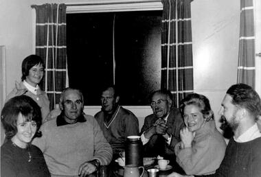
Photograph - Fred Griffith and friends at Bowna Ski Club, July 1962
Frederick Charles “Fred” Griffith was born in Albury, NSW on 2 March 1910. Educated in Albury and Geelong Grammar. Beginning in 1927 he spent many years working first as a jackeroo and on a range of prominent pastoral and merino stud properties in NSW and Queensland. In 1935 he repurchased his former family property “Toonallook", Bowna, NSW and developed it to be the largest Romney Marsh stud in the world, exporting rams to Argentina. He introduced many innovative practices on his property including rabbit control measures and aerial crop dusting. He was an active member of the Albury Show Society and in 1949 established the Albury Sheep Show. Fred was also the Albury representative on the Graziers’ Association Council for over 30 years. He became a life member of both the Albury and Commercial Clubs. Fred’s greatest hobby was snow skiing. His first visit to the snow was to Kosciusko in 1919. The Albury Ski Club was formed in 1935 and Fred was an inaugural member. In 1949 they were granted a site at Falls Creek to build their own lodge. Fred guaranteed the Club for finance from the Bank of NSW. The first portion of the prefabricated building was constructed in Albury. It was transported to Falls Creek on the back of Fred’s truck and erected in one day. This was the bathroom section and the rest was completed in 1950. The original lodge was burned down in 1952 and a new one built the following year. In 1955, Fred also built the Bowna Lodge for his family in partnership with David Fairbairn. He became head of the North Eastern District Skiing Association (N.E.D.S.A.) and successfully applied to run the Australian Ski Championships. Fred also inaugurated children’s races at Falls Creek and ran them for about 20 years. He also formed the company “Falls Creek Ski Tows”. In 1956 Fred along with a group of key people selected the site for Thredbo Village. Fred and his brother sold Toonallook in sections between 1951 and 1974. He moved to Albury and set up as a landscape gardener and fencing contractor. After a serious work accident, Fred retired in 1985 and moved to Rosebud, Victoria where he died on 19 August 1992. Bowna is now known as the Riverina Ski Club.This image depicts Fred Griffith who was a pioneer of the Albury Ski Club and Falls Creek2 black and white photos Fred Griffith with friends at Bowna Ski Club in 1962On back of photo 1 in pencil: Group in the kitchen at my lodge in Falls Creek, July 1962. L. TO R: Daughter Christine (18), Diane (2), self, WIng Commander Peter Kemp, Captain MIchin, Thea Hedley + Lt. Commander Keith Wehe R.N. On back of photo 2 in pencil: Falls Creek, July 1962fred griffith, albury ski club, falls creek, bowna ski club -
 Ringwood and District Historical Society
Archive - Biographical material, Maggs Family of Ringwood and District (Parent Record)
Transcript of the Maggs Family History, given by Joan Walker, former member of RDHS:- Pioneer Family - Maggs • James Maggs and wife Harriet Banfield migrated to Melbourne on the “Ticondergoa” which sailed from Birkenhead on 4th August 1852 with 812 assisted immigrants. • In 1856 James purchased 7 acres of land, part of section 75, in the parish of Nunawading where he developed an orchard. • Three children died young – Emma (before 1862), Jemima at Ticonderoga Bay and Mary Jane aged 3 weeks at Koonung Creek. Three sons and a daughter survived them. Harriet died in 1875, James in 1888 both buried in Box Hill cemetery. • Their sons Joseph, Samuel and James all established orchards in the Ringwood/Croydon district. Samuel Maggs • Born 11 May 1851, Somerset, England and grew up on his fathers property in Springfield Road, Blackburn, one block east of Surrey Road. • On 4 October 1876 Sam married Eliza Ann Barnes. • 1881 purchased a block, Allot. 39 Parish of Warrandyte and developed an apple and cherry orchard. The orchard occupied the area between White Horse Road and Mullum Mullum Creek from Oban Rd east to where White Horse Road takes a slight turn to the right, near Burnt Bridge. • Son George b.28 December 1876 Warrandyte married Annie Smith d.9 May 1947. • Daughter Eliza Jane b.27 July 1878 Ringwood married William Dobbin, d.31 May 1946 Camberwell. • Son James b.15 May 1880, Lilydale married Catherine Atkins d.28 July 1940 Ringwood buried Box Hill. • Daughter Jemima b.16 December 1881 Warrandyte married Edward Lindsay in 1905, d.2 November 1955 and buried in Box Hill. • Daughter Jane b.22 May 1884 Warrandyte married Thomas S Knee in 1912 d.31 January 1971, buried at Box Hill. • Son Samuel William b.1 Jan 1889 Ringwood married Mina Lillian Schuhkraft in 1911 d.15 Jan 1955 Ringwood. Joseph Maggs • Born 5 June 1845, Somerset England. • Married Mary Ann Reid in April 1867 at Templestowe. • Bought Sec. 26a, in Ringwood on the corner of Eastfield Road an Mt Dandenong Road in February 1870. Planted 4 acres with fruit trees. Was also a wood carter. During the 1880s white clay was mined here, which he carted for the Victorian Porcelain Clay Coy. • Daughter Emma b.8 Jan 1868 Templestowe d. 3 August 1939, Richmond married May 1890 Fredrick W. McGinnis. • Daughter Agnes b.16 June 1869 Templestowe married John D Miller c.1894. d.3 February 1912 Heathmont, buried Box Hill. • Son Albert b.1 May 1871 Nunawading d.15 Nov 1893. • Son Hubert b.10 May 1873 Nunawading married Isabella Atkins in 1898 Ringwood d.11 August Wagga Wagga and buried there. • Daughter Harriet Annis b.13 August 1875 Box Hill d.21 Sept 1875. • Son Joseph b.25 September 1876 Box Hill d.3 Oct 1900 Mitcham. • Daughter Harriet Annis b.18 Aug 1879, Ringwood married James R Miller d.8 May 1945. • Son William b.3 Sep 1881 married Mary E Hardidge. D.6 April 1950 South Melbourne. • Daughter Dora Jane Dulcie b.13 December 1883 Ringwood d.1973. • Daughter Delia Rose b.20 February 1886, Ringwood married William J Sharkie d.30 October 1914 James Maggs • Youngest (born 28 April 1862, Blackburn) and only Australian born son was also an orchardist. • Married Marianne Hardidge in 1880 (divorced in 1906) purchased land in what is now Kalinda Road, adjoining Sam’s land. • James lived with Teresa Shanks in the Hawthorn and Prahran districts and became a taxi driver. Died in 1925, buried at Box Hill. Marianne became a midwife who delivered over 500 babies in the area – was known as Nurse Polly Maggs, died in 1941 aged 81. • Daughter Mary Ann Hase Polly b.5 July 1881 Ringwood married Thomas Lawford d.9 November 1961 buried at Box Hill. • Daughter Jane Emma b.9 May 1883 Ringwood married Frederick Bloom 1910 d.28 July 1954. • Daughter James John b.17 Jan 1885 Ringwood married Johanna Ida Edith Bloom in 1912 d.24 August 1962 buried at Box Hill. • Daughter David Joseph b.31 Jan 1887 Ringwood married Violet Lepp married 1916, d.11 July 1966. • Son Samuel Arthur b.11 March 1888 Ringwood married Bertha Anna Pump in 1913 d.7 August 1957. • Son John William b.16 April 1890 Ringwood married Lillian Mabel May Smith in 1909 d.18 February 1959 Cobram. • Daughter Eliza Anne b.6 March 1892 Ringwood d.April 18 1892. • Son Robert Thomas b.7 March 1893 Ringwood married Edith E Britnell in 1919 d.12 March 1981 buried Box Hill. • Son Albert Edward b.12 April 1895 Ringwood married Florence Sarah Pearce in 1918 d.30 January 1976 buried at Springvale. • Daughter Evaleen Victoria b.28 Aug 1897, Ringwood married Sydney Till married 1920 d.5 September 1989 buried at Box Hill. • Daughter Harriet Banfield Chrissy b.14 December 1899 Ringwood d.28 Dec 1979 buried Box Hill. Jane Maggs • Born 19 December 1858 in Blackburn. Died 5 July 1926 buried at Box Hill. Married William Cook and had one child, Harriet Amy Cook who never married and lived in Whitehorse Road, Mitcham until her death in 1962. Details, extract from Family Tree Maker family tree:- Descendants of James Maggs Generation No. 1 1. JAMES5 MAGGS (JOSEPH4, WILLIAM3, WILLIAM2, SAMUEL1)1 died 24 Sep 18881. He married (1) HARRIET MARTHA BANFIELD1 23 Dec 1841 in Bristol, Somerset, England1. She was born 19 Jun 1817 in Clutton, Somerset, England1, and died 12 May 1875 in Nunawading, Victoria, Australia1. He married (2) ROSENA MAHON1 09 Dec 1875 in Fitzroy, Victoria, Australia1. She was born in Deptford, London, England1. Notes for JAMES MAGGS: JAMES MAGGS, and his wife HARRIET BANFIELD, migrated to Melbourne on the "Ticonderoga", which sailed from Birkenhead 4th Aug 1852 with 812 assisted immigrants aboard. In the close confines of the ship fever broke out and by the time she arrived off Port Phillip Heads on or about 2nd Nov, 100 deaths had been recorded in the log and hundreds were too weak to help themselves. Captain Wylie of the coastal trader "Champion", informed Captain Ferguson, the harbourmaster at Williamstown, of the tragic plight of the passengers and crew, and he came with two doctors, in the "Empire", to their aid. They anchored just inside Port Phillip Heads on 5 Nov. at the "Sanatory Station", declared but not yet established by the local authorities. Those who were well enough were put ashore in tents made of spars and sails. The "Lysander" was despatched from Melbourne to act as a hospital ship, and 2 houses, built of the local limestone, were commandeered as a quarantine station. For six weeks the survivors were held near Point Nepean at a place still known as Ticonderoga Bay while the fever, propably typhus, a louse borne epidemic disease, ran its course and a further 68 passengers, 2 crew members and 4 newborn babes succumbed to the scourge. Among them was Jemima Maggs, 3 year old daughter of James and Harriet. The dead were buried at the waters edge, in a grove of titree, a site now marked by Heaton's monument. The remainder of the family, including Samuel, just one year old, lived through the ordeal to make a new life in Australia. James obtained work with Robert Wilson of Bulleen for a period of 3 months at a wage of 52 pounds per annum with rations. By 1856 he was able to purchase 7 acres of land, part of section 75, in the parish of Nunawading at 5 pounds per acre. Here he developed an orchard by means of various mortgages including one taken out 17 July 1872 for 50 pounds from the Victorian Permanent Property Investment & Building Society. Three of their seven children died young, Emma before 1862, Jemima at Ticonderoga Bay, and Mary Jane, the first of their three Australian born children, aged 3 weeks at Konung Creek.Three sons and a daughter survived them. Harriet died in 1875, James lived until 1888 and both are buried at the Box Hill Cemetery. Their sons, Joseph, Samuel, and James all established orchards in the Ringwood/Croydon district. Bur Reg 308 Box Hill Grave #64 Presbyterian More About JAMES MAGGS: Ancestral File Number: LN0V-G01 Burial: 26 Sep 1888, Box Hill, Victoria, Australia1 Christening: 20 Oct 1816, Clutton, Somerset, England1 Record Change: 03 Oct 20041 More About HARRIET MARTHA BANFIELD: Ancestral File Number: LN0V-N11 Burial: 14 May 1875, Box Hill, Victoria, Australia1 Christening: 31 Aug 18171 Record Change: 29 Nov 20041 More About ROSENA MAHON: Record Change: 01 Dec 20011 Children of JAMES MAGGS and HARRIET BANFIELD are: i. EMMA6 MAGGS1, b. 13 Nov 1843, Clutton, Somerset, England1. More About EMMA MAGGS: Record Change: 08 Jul 20031 2. ii. JOSEPH MAGGS, b. 05 Jun 1845, Clutton, Somerset, England; d. 24 Jun 1886, Ringwood, Victoria, Australia. iii. JEMIMA MAGGS1, b. 25 Oct 1848, Clutton, Somerset, England1; d. 1852, Ticonderoga Bay, Victoria, Australia1. More About JEMIMA MAGGS: Record Change: 24 Jan 20031 3. iv. SAMUEL MAGGS, b. 11 May 1851, Clutton, Somerset, England; d. 30 Aug 1942, Croydon, Victoria, Australia. v. MARY JANY MAGGS1, b. 03 Dec 1855, Konung Creek, Victoria, Australia1; d. 27 Dec 18551. More About MARY JANY MAGGS: Record Change: 23 Jan 20051 4. vi. JANE MAGGS, b. 19 Dec 1858, Blackburn, Victoria, Australia; d. 05 Jul 1926, , Victoria, Australia. 5. vii. JAMES MAGGS, b. 1862, Nunawading; d. 1925, Fitzroy. Generation No. 2 2. JOSEPH6 MAGGS (JAMES5, JOSEPH4, WILLIAM3, WILLIAM2, SAMUEL1)1 was born 05 Jun 1845 in Clutton, Somerset, England1, and died 24 Jun 1886 in Ringwood, Victoria, Australia1. He married MARY ANN READ1 01 Apr 1867 in Templestowe, Victoria, Australia1. She was born Abt. 1847 in of Templestowe, Victoria, Australia1, and died 1925 in Ringwood, Victoria, Australia1. Notes for JOSEPH MAGGS: Joseph Maggs born 5 Jun 1845 at Clutton, Somerset, England, arrived in Australia age 7 years. He married Mary Ann Read, in Apr 1867 at Templestowe, selected land, Lot 26a,in Ringwood on the corner of Eastfield Road and Mt.Dandenong Road, approx 114 acres, at 11 o'clock 2 Feb 1870. He planted 4 acres with fruit trees valued at 80 pounds and by Sep 1874 his occupation was farmer and wood carter. A 4 room house of lathe and plaster with a paling roof, a kitchen, a slab and bark stable and a pigsty had been errected to a value of 71 pounds. A well, 3 dams, clearing and fencing valued at 96 pounds are also listed. He notes "from the nature of the land, being very poor and heavily timbered, I have not been quite able to clear the complement required, not having means sufficient to do so, neither will the land pay when cultivated." Traces of antimony were found on the land but not in commercial quantities, however during the 1880s white clay was mined here, which he carted for the Victoria Porcelain Clay Coy. In Mar 1880 he was granted freehold title at a price of one pound per acre. More About JOSEPH MAGGS: Burial: Box Hill, Victoria, Australia1 Record Change: 18 Feb 20011 More About MARY ANN READ: Burial: Box Hill, Victoria, Australia1 Record Change: 21 Jul 20021 Children of JOSEPH MAGGS and MARY READ are: 6. i. EMMA7 MAGGS, b. 08 Jan 1868, Templestowe, Victoria, Australia; d. 03 Aug 1939, Richmond, Victoria, Australia. ii. ALBERT MAGGS1, b. 01 May 1871, Nunawading, Victoria, Australia1; d. 15 Nov 1893, Ringwood, Victoria, Australia1. More About ALBERT MAGGS: Record Change: 12 Oct 19971 7. iii. HUBERT MAGGS, b. 10 May 1873, Ringwood, Victoria, Australia; d. 11 Aug 1956, Wagga Wagga, N.S.W., Australia. iv. HARRIET ANNIS MAGGS1, b. 13 Aug 1875, Box Hill, Victoria, Australia1; d. Ringwood, Victoria, Australia1. More About HARRIET ANNIS MAGGS: Burial: 21 Sep 1875, Box Hill, Victoria, Australia1 Record Change: 18 Feb 20011 v. JOSEPH MAGGS1, b. 25 Sep 1876, Box Hill, Victoria, Australia1; d. 03 Oct 1900, Mitcham, Victoria, Australia1. More About JOSEPH MAGGS: Record Change: 18 Feb 20011 8. vi. HARRIET ANNIS MAGGS, b. 18 Aug 1879, Ringwood, Victoria, Australia; d. 08 May 1945. vii. WILLIAM MAGGS1, b. 03 Sep 18811; d. 06 Apr 1950, South Melbourne, Victoria, Australia1; m. MARY ELIZA HARDIDGE1, 24 Dec 1912, Goulburn, N.S.W., Australia1; b. Abt. 1884, , of Victoria, Australia1; d. 1956, Lilydale, Victoria, Australia1. More About WILLIAM MAGGS: Record Change: 18 Feb 20011 More About MARY ELIZA HARDIDGE: Record Change: 18 Feb 20011 viii. DORA JANE DULCIE MAGGS1, b. 13 Dec 1883, Ringwood, Victoria, Australia1; d. 1973, Mitcham, Victoria, Australia1. More About DORA JANE DULCIE MAGGS: Record Change: 21 Jan 20021 9. ix. DELIA ROSE MAGGS, b. 20 Feb 1886, Ringwood, Victoria, Australia; d. 30 Oct 1914. 10. x. AGNES MAGGS, b. 16 Jun 1869, Templestowe, Victoria, Australia; d. 03 Feb 1912, Heathmont, Victoria, Australia. 3. SAMUEL6 MAGGS (JAMES5, JOSEPH4, WILLIAM3, WILLIAM2, SAMUEL1)1 was born 11 May 1851 in Clutton, Somerset, England1, and died 30 Aug 1942 in Croydon, Victoria, Australia1. He married ELIZA ANN BARNES1 04 Oct 1876 in Nunawading, Victoria, Australia1. She was born 19 Sep 1848 in St Lukes, London, England1, and died 17 Feb 1923 in Croydon, Victoria, Australia1. Notes for SAMUEL MAGGS: SAMUEL MAGGS grew up on his father's property in Springfield Road, Blackburn, one block east of Surrey Road. West of Surrey Road and fronting to White Horse Road was James Barnes' property, so by walking through the Maggs land and crossing Surrey Road, one might enter the back of the Barnes land, an easy way to visit ELIZA ANN BARNES. On the 4 Oct 1876 Sam and Eliza were married at her father's house. Sam wrote to the Secretary for Lands on the 29 Sep 1880, requesting that Allot. 39 Parish of Warrandyte be made available for selection. This block had been refused for selection earlier on the objection of the Mines Department as it was believed that the area was auriferous. When told that the block was available, Sam marked it at 5 o'clock December 3rd and applied for a lease of 12 acres 3 rods and 34 perches on the 6th December. On the application it is noted that he already had leasehold of 104 acres. His license was approved 7 Mar 1881 at a rate of 6 shillings and 6 pence per halfyear. Previously paid fees and rental came to 3 pounds 18 shillings, and he paid another pound for a certificate fee, a pound lease fee, plus the first half years rental, then proceeded to develop the land into an apple and cherry orchard.In 7 Mar 1898 he had succeeded in securing the freehold grant of the area by paying 2 pounds 18 shillings 6 pence fees due,plus a 1 guinea grant fee and assurance fund contribution of 7 pence, a total of 4 pounds and 1 penny. The orchard occupied the area between White Horse Rd and Mullum Mullum Creek,from Oban Rd east to where White Horse Road, now the Maroondah Highway, takes a slight turn to the right, near the Burnt Bridge. Sam and Eliza built a house on Sec38 and planted Fivecrown apples grafted on a Maggs Seedling stock at 24 ft spacing. Trees put in about 1875 were yielding up to twenty bushells 30 years later. He didn't approve of regulations which required spraying for codlin moth and was reputed to have said when denied coolstorage space until he sprayed his trees, "No one is going to tell me how to grow apples and anyway a bit of codlin is good for you". More About SAMUEL MAGGS: Ancestral File Number: LN0V-8X1 Record Change: 20 Aug 19971 Notes for ELIZA ANN BARNES: ELIZA ANN BARNES married SAMUEL MAGGS, son of neighbouring land owner, James Maggs, 4 Oct 1876 and had 6 children. She had a stroke about 1921 but was able to attend her seventyfourth birthday party held at her daughter Jane Knee's home in Sep 1922 when over forty family members gathered for the celebration(see photo). She died 17 Feb 1923 at Croydon. More About ELIZA ANN BARNES: Ancestral File Number: LN0V-2W1 Record Change: 20 Aug 19971 Children of SAMUEL MAGGS and ELIZA BARNES are: 11. i. GEORGE7 MAGGS, b. 28 Dec 1876, Warrandyte, Victoria, Australia; d. 09 May 1947, Ringwood, Victoria, Australia. 12. ii. ELIZA JANE MAGGS, b. 27 Jul 1878, Ringwood, Victoria, Australia; d. 31 May 1946, Camberwell, Victoria, Australia. 13. iii. JAMES MAGGS, b. 15 May 1880, Lilydale, Victoria, Australia; d. 28 Jul 1940, Ringwood, Victoria, Australia. iv. JANE MAGGS1, b. 22 May 1884, Warrandyte, Victoria, Australia1; d. 31 Jan 19711; m. THOMAS SAMUEL KNEE1, 1907, , Victoria, Australia1; b. 07 Aug 1881, Lilydale, Victoria, Australia1; d. 19 Apr 19601. More About JANE MAGGS: Burial: Box Hill, Victoria, Australia1 Record Change: 18 Feb 20011 More About THOMAS SAMUEL KNEE: Burial: 21 Apr 1960, Box Hill, Victoria, Australia1 Record Change: 22 Aug 20031 14. v. SAMUEL WILLIAM MAGGS, b. 01 Jan 1889, Ringwood, Victoria, Australia; d. 15 Jan 1955, Ringwood, Victoria, Australia. 15. vi. JEMIMA MAGGS, b. 16 Dec 1881, Warrandyte, Victoria, Australia; d. 02 Nov 1955. 4. JANE6 MAGGS (JAMES5, JOSEPH4, WILLIAM3, WILLIAM2, SAMUEL1)1 was born 19 Dec 1858 in Blackburn, Victoria, Australia1, and died 05 Jul 1926 in , Victoria, Australia1. She married WILLIAM COOK1 1880 in , Victoria, Australia1. He was born Abt. 1859 in Wickliffe, Victoria, Australia1, and died 09 Aug 19391. Notes for JANE MAGGS: Jane Maggs, the only surviving daughter of James and Harriet, married William Cook and had one child, Harriet Amy Cook, known to her relatives as Cousin Amy. She never married and lived in the house inWhitehorse Road, Mitcham built by her parents, for many years until her death in 1962. She took a keen interest in family history and was a great source of information and memorabilia about the early days of the Ringwood area. More About JANE MAGGS: Burial: Box Hill1 Record Change: 18 Feb 20011 More About WILLIAM COOK: Burial: 10 Aug 1939, Box Hill, Victoria, Australia1 Record Change: 05 Nov 20011 Child of JANE MAGGS and WILLIAM COOK is: i. HARRIET AMEY7 COOK1, b. 1881, Box Hill, Victoria, Australia1; d. 13 Sep 1962, Surrey Hills, Victoria, Australia1. More About HARRIET AMEY COOK: Burial: 17 Sep 1962, Box Hill, Victoria, Australia1 Record Change: 18 Feb 20011 5. JAMES6 MAGGS (JAMES5, JOSEPH4, WILLIAM3, WILLIAM2, SAMUEL1)2,3 was born 1862 in Nunawading4, and died 1925 in Fitzroy4. He married (1) THERESA BROWN4 in Christchurch, New Zealand5. She was born 1869 in Clunes, Victoria, Australia5, and died 1930 in Prahran, Victoria, Australia5. He married (2) MARIANNE HARDIDGE6 1880 in Kew6. She was born 1860 in Doncaster6, and died 1941 in Mitcham6. He married (3) ADA JANE CROY7 19127. She was born 1883 in ,Victoria, Australia7. Notes for JAMES MAGGS: James Maggs, the youngest child and only Australian born son of James and Harriet, was an orchardist like his older brothers. He married Marianne Hardidge in 1880 and selected an area in what is now Kalinda Road, adjoining Sam's land. They constructed a four roomed house measuring 26 feet square valued at fifty pounds and stables valued at forty pounds. The buildings were made of palings with an iron roof. Here they raised ten children and lost a little girl, Eliza, aged three weeks. In 1900 James became seriously ill with a kidney disease and was visited during his illness by a wide section of his neighbours, including Mrs Theresa Shanks. He and Theresa became attracted to each other and broke up their marriages, with James and Marianne being divorced in 1906. James and Theresa lived in the Hawthorn and Prahran districts and he became a taxi driver. He contributed to the upkeep of his children although the divorce was a bitter affair. He died in 1925 in Fitzroy and Theresa only survived him by five years. They are buried in the same grave at Box Hill. Marianne became a midwife who delivered over 500 babies in the neighborhood. She was known as Nurse Polly Maggs and the people of Ringwood presented her with a wireless set in appreciation of her service to the community. She died at the age of 81 years in 1941. More About JAMES MAGGS: Burial: Box Hill Cemetery8 Record Change: 01 Sep 20018 Notes for THERESA BROWN: [Ringwood.ged] Theresa had a son Jim Shanks born1902 (father was James Maggs) Reg No 12243R More About THERESA BROWN: Burial: 05 Feb 1930, Box Hill, Victoria, Australia9 Record Change: 01 Sep 200110 More About MARIANNE HARDIDGE: Burial: Box Hill Cemetery10 Record Change: 01 Sep 200110 Marriage Notes for JAMES MAGGS and MARIANNE HARDIDGE: [Ringwood.ged] divorced in 1906 More About ADA JANE CROY: Burial: 15 Apr 1932, Geelong, Victoria, Australia11 Record Change: 10 Aug 200211 Child of JAMES MAGGS and THERESA BROWN is: i. JIM7 MAGGS12, b. 190212. More About JIM MAGGS: Record Change: 01 Sep 200112 Children of JAMES MAGGS and MARIANNE HARDIDGE are: ii. MARY ANN HASE7 MAGGS12, b. 188112. More About MARY ANN HASE MAGGS: Record Change: 01 Sep 200112 16. iii. JANE EMMA MAGGS, b. 1883; d. 28 Jul 1954. 17. iv. JAMES JOHN MAGGS, b. 1885; d. 24 Aug 1962, Parkville, Victoria, Australia. v. DAVID JOSEPH MAGGS12,13, b. 188714; d. 11 Jul 1966, Mt. Waverley, Victoria, Australia15; m. VIOLET ADELINE LEPP15, 1916, , Victoria, Australia15; b. 1888, Ballarat, Victoria, Australia15; d. 26 Mar 1966, ,Victoria, Australia15. More About DAVID JOSEPH MAGGS: Record Change: 01 Sep 200116 More About VIOLET ADELINE LEPP: Record Change: 21 Jan 200217 18. vi. SAMUEL ARTHUR MAGGS, b. 1888; d. 07 Aug 1957, Doncaster, Victoria, Australia. 19. vii. JOHN WILLIAM MAGGS, b. 1890; d. 18 Feb 1959, Cobram, Victoria, Australia. viii. ELIZA ANN MAGGS18, b. 189218; d. 189218. More About ELIZA ANN MAGGS: Burial: Box Hill Cemetery18 Record Change: 01 Sep 200118 20. ix. ROBERT THOMAS MAGGS, b. 1893; d. 12 Mar 1981. 21. x. ALBERT EDWARD MAGGS, b. 1895; d. 1976. 22. xi. EVALEEN VICTORIA MAGGS, b. 1897; d. 05 Sep 1989. xii. HARRIET BANFIELD MAGGS18, b. 189918. More About HARRIET BANFIELD MAGGS: Record Change: 01 Sep 200118 23. xiii. MARY ANN HASE POLLY MAGGS, b. 05 Jul 1881, Ringwood, Victoria, Australia; d. 09 Nov 1961. xiv. HARRIET BANFIELD CHRISSY MAGGS19, b. 14 Dec 1899, Ringwood, Victoria, Australia19; d. 28 Dec 1979, Blackburn, Victoria, Australia19. More About HARRIET BANFIELD CHRISSY MAGGS: Burial: Box Hill19 Record Change: 18 Feb 200119 Children of JAMES MAGGS and ADA CROY are: xv. CLENCIE JOAN7 MAGGS19, m. ARTHUR RODERICK PITTER19. xvi. CLYDE MAGGS19, b. 1917, Collingwood, Victoria, Australia19; d. 1917, Collingwood, Victoria, Australia19. More About CLYDE MAGGS: Record Change: 10 Aug 200219 Generation No. 3 6. EMMA7 MAGGS (JOSEPH6, JAMES5, JOSEPH4, WILLIAM3, WILLIAM2, SAMUEL1)19 was born 08 Jan 1868 in Templestowe, Victoria, Australia19, and died 03 Aug 1939 in Richmond, Victoria, Australia19. She married FREDRICK WILLIAM MCGINNIS19 May 1890 in , Victoria, Australia19. He was born in , of Victoria, Australia19. More About EMMA MAGGS: Record Change: 18 Feb 200119 More About FREDRICK WILLIAM MCGINNIS: Record Change: 18 Feb 200119 Children of EMMA MAGGS and FREDRICK MCGINNIS are: i. RENIRA EDDA8 MCGINNIS19. ii. FREDRICK HENRY MCGINNIS19, b. 1894, , of Victoria, Australia19; d. 195819. More About FREDRICK HENRY MCGINNIS: Record Change: 18 Feb 200119 7. HUBERT7 MAGGS (JOSEPH6, JAMES5, JOSEPH4, WILLIAM3, WILLIAM2, SAMUEL1)19 was born 10 May 1873 in Ringwood, Victoria, Australia19, and died 11 Aug 1956 in Wagga Wagga, N.S.W., Australia19. He married ISABELLA ATKINS19 09 Mar 1898 in Ringwood, Victoria, Australia19. She was born Abt. 1875 in St Arnaud, Victoria, Australia19. More About HUBERT MAGGS: Burial: Wagga Wagga, N.S.W., Australia19 Record Change: 23 Jan 200519 More About ISABELLA ATKINS: Record Change: 23 Jan 200519 Children of HUBERT MAGGS and ISABELLA ATKINS are: i. HUBERT CARLYLE8 MAGGS19. ii. ANNE THORA MAGGS19. iii. RAYMOND MAGGS19, b. 09 Jun 1905, Ringwood, Victoria, Australia19; d. 20 Jul 190519. More About RAYMOND MAGGS: Record Change: 18 Feb 200119 8. HARRIET ANNIS7 MAGGS (JOSEPH6, JAMES5, JOSEPH4, WILLIAM3, WILLIAM2, SAMUEL1)19 was born 18 Aug 1879 in Ringwood, Victoria, Australia19, and died 08 May 194519. She married JAMES RICHARD MILLER19 26 Sep 1910 in Ringwood East, Victoria, Australia19. He was born 1878 in Collingwood, Victoria, Australia19. More About HARRIET ANNIS MAGGS: Record Change: 18 Feb 200119 More About JAMES RICHARD MILLER: Record Change: 18 Feb 200119 Children of HARRIET MAGGS and JAMES MILLER are: i. DUDLEY8 MILLER19. ii. IRENE DOROTHY MILLER19, b. 10 Nov 1913, , of Victoria, Australia19; d. 29 Sep 199019. More About IRENE DOROTHY MILLER: Burial: Lilydale, Victoria, Australia19 Record Change: 18 Feb 200119 iii. CYRIL MILLER19, b. 26 Sep 1915, , of Victoria, Australia19; d. 05 Apr 197319. More About CYRIL MILLER: Burial: Springvale, Victoria, Australia19 Record Change: 18 Feb 200119 9. DELIA ROSE7 MAGGS (JOSEPH6, JAMES5, JOSEPH4, WILLIAM3, WILLIAM2, SAMUEL1)19 was born 20 Feb 1886 in Ringwood, Victoria, Australia19, and died 30 Oct 191419. She married WILLIAM JAMES SHARKIE19. More About DELIA ROSE MAGGS: Burial: Box Hill, Victoria, Australia19 Record Change: 18 Feb 200119 Child of DELIA MAGGS and WILLIAM SHARKIE is: i. RONALD8 SHARKIE19, b. Abt. 1914, , of Victoria, Australia19; d. Abt. 1964, , N.S.W., Australia19. More About RONALD SHARKIE: Record Change: 15 Oct 200119 10. AGNES7 MAGGS (JOSEPH6, JAMES5, JOSEPH4, WILLIAM3, WILLIAM2, SAMUEL1)20,21 was born 16 Jun 1869 in Templestowe, Victoria, Australia21, and died 03 Feb 1912 in Heathmont, Victoria, Australia21. She married (1) JOHN DOMONIC MILLER22 189423,24, son of FRANK MILLER and KATE MADDEN. He was born 187025,26, and died 194227,28. She married (2) JOHN DOMINIC MILLER29 1894 in , Victoria, Australia30,31. He was born 1870 in Box Hill, Victoria, Australia31. More About AGNES MAGGS: Burial: Box Hill, Victoria, Australia31 Record Change: 11 Sep 200132 More About JOHN DOMONIC MILLER: Record Change: 11 Sep 200132 More About JOHN DOMINIC MILLER: Record Change: 18 Feb 200133 Children of AGNES MAGGS and JOHN MILLER are: i. ALBERT JOHN8 MILLER33, b. 1894, , of Victoria, Australia33. More About ALBERT JOHN MILLER: Record Change: 18 Feb 200133 ii. LOUIS NICHOLAS MILLER33, b. 1901, , of Victoria, Australia33; d. 197433; m. LILA MERTON33. More About LOUIS NICHOLAS MILLER: Record Change: 18 Feb 200133 iii. LESLIE DOMINIC MILLER33, b. 1904, , of Victoria, Australia33; d. 198933. More About LESLIE DOMINIC MILLER: Record Change: 18 Feb 200133 11. GEORGE7 MAGGS (SAMUEL6, JAMES5, JOSEPH4, WILLIAM3, WILLIAM2, SAMUEL1)33 was born 28 Dec 1876 in Warrandyte, Victoria, Australia33, and died 09 May 1947 in Ringwood, Victoria, Australia33. He married ANNIE GRACE SMITH33 26 Mar 1902 in , Victoria, Australia33. She was born Abt. 1878 in of Ringwood, Victoria, Australia33, and died 1967 in Box Hill, Victoria, Australia33. More About GEORGE MAGGS: Record Change: 18 Feb 200133 More About ANNIE GRACE SMITH: Record Change: 21 Jan 200233 Children of GEORGE MAGGS and ANNIE SMITH are: i. CLYDE8 MAGGS33, m. VIOLET OXENBURY33. 24. ii. GEORGE ALBERT MAGGS, b. 17 Jul 1902, Ringwood, Victoria, Australia; d. 1974, Heidelberg, Victoria, Australia. iii. HILDA GLADYS BILLIE MAGGS33, b. 05 Sep 1903, Ringwood, Victoria, Australia33; d. 15 Oct 198733; m. LENARD DRYSDALE REID33. More About HILDA GLADYS BILLIE MAGGS: Burial: Springvale, Victoria, Australia33 Record Change: 18 Feb 200133 iv. MYRTLE OLIVE MAGGS33, b. 24 Dec 1905, Kew, Victoria, Australia33; d. 02 Jan 198333; m. ROBERT SAMUEL BOB HEAD33, 1924, , Victoria, Australia33; b. 1898, , of Victoria, Australia33; d. 15 Oct 1980, Mermaid Beach, Queensland, Australia33. More About MYRTLE OLIVE MAGGS: Record Change: 18 Feb 200133 More About ROBERT SAMUEL BOB HEAD: Burial: 17 Oct 1980, Nerang, Queensland, Australia33 Record Change: 18 Feb 200133 v. FREDERICK STANLEY MAGGS33, b. 10 Jul 1907, of, Victoria, Australia33; d. 26 Jan 1975, Box Hill, Victoria, Australia33; m. (1) RUBY EMILY BRIERLEY33; m. (2) SARAH MRS FREDERICK MAGGS33; m. (3) ISABEL WOOD33. More About FREDERICK STANLEY MAGGS: Record Change: 21 Jul 200233 vi. ALFRED FRANCIS MAGGS33, b. 19 Jun 1909, Ringwood, Victoria, Australia33; d. 06 Feb 198733; m. FRANCES ESTELLE WILLOUGHBY33. More About ALFRED FRANCIS MAGGS: Record Change: 18 Feb 200133 vii. ERIC RAYMOND MAGGS33, b. 29 Nov 1910, Ringwood, Victoria, Australia33; d. 29 Jan 198633; m. THELMA THOMPSON33. More About ERIC RAYMOND MAGGS: Record Change: 18 Feb 200133 viii. MARJORIE FLORENCE MAGGS33, b. 21 Jun 1912, Ringwood, Victoria, Australia33; d. 20 Aug 197433; m. COLIN ADDISON33. More About MARJORIE FLORENCE MAGGS: Record Change: 18 Feb 200133 ix. CLARICE MAGGS33, b. 20 Dec 1913, , Victoria, Australia33; m. RONALD STONE33. More About CLARICE MAGGS: Burial: , Queensland, Australia33 Record Change: 18 Feb 200133 12. ELIZA JANE7 MAGGS (SAMUEL6, JAMES5, JOSEPH4, WILLIAM3, WILLIAM2, SAMUEL1)33 was born 27 Jul 1878 in Ringwood, Victoria, Australia33, and died 31 May 1946 in Camberwell, Victoria, Australia33. She married WILLIAM NEWCOMB DOBBIN33 14 Mar 1900 in Ringwood, Victoria, Australia34,35. He was born 02 Aug 1878 in Bendigo, Victoria, Australia35, and died 12 May 1960 in Brighton, Victoria, Australia35. More About ELIZA JANE MAGGS: Ancestral File Number: LN0T-NV35 Record Change: 20 Aug 199735 Notes for WILLIAM NEWCOMB DOBBIN: WILLIAM NEWCOMB DOBBIN, the second child of William Edward Jones Dobbin and Amelia Matilda Shoman, was born at Bendigo in the state of Victoria, on the 2 August 1878. He spent his early childhood years in the goldfields towns of Bendigo and Ballarat but by the time he was of age to start school his family had moved to Melbourne and he commenced his education at the Richmond State school. His first job as a baker's boy in Ringwood included delivering bread by bicycle to homes in that area, and that was how he met ELIZA JANE MAGGS. By the time he turned 17 he had decided to go to Western Australia so in 1895 he embarked on a ship named the "Inaminka" which carried a deck cargo of draught horses. While crossing the Great Australian Bight a severe storm was encountered and three of the fifteen horses on deck were killed. He found work in a timber camp in the south west,near Albany, and lived in a hut made of palings for a time with five other men. While he was there an itinerant Indian photographer named S.Bhan took a picture of the hut with its inhabitants standing outside. Approaching the turn of the century his mind turned to thoughts of marriage. He returned to Victoria and proposed to Eliza Jane. They were married on the 14 March 1900 at Lilydale Road Ringwood according to the rites of the Church of Christ by Thomas Hagger in the presence of George Maggs,the brother of the bride and Elizabeth Frances Bell. He and his bride returned to Western Australia on a ship called the "Oruba" and when their first child was born at Denmark, on the 18 January 1901 he named her VERA ORUBA DOBBIN. Eliza Jane found the living conditions very rough and because of poor health she returned to Victoria when Vera was three months old. William followed on a ship called the "Suvic". Their second child, Cyril William Dobbin was born at Ringwood in October 1902 where William worked an orchard owned by his father-in-law, Sam Maggs. He purchased from Sam an area in Wonga Park Rd, (now Kalinda Rd) north of the creek which had been planted as a cherry orchard and part of the area on the corner of Oban Road He also worked in a pottery and in the 1905 Sands and McDougall directory he is listed as a brick and tile maker. In 1917 he rented premises in Main Street (Whitehorse Road), Ringwood, then newly built by J.B.McAlpin, the estate agent, on the corner of Melbourne Street. The shop between A.C.Beilby's store and McAlpin's office on the corner was opened as "The Railway Fruit and Confectionary Palace" and a shop in Melbourne Street, which adjoined the Main Street shop at the rear, became "The Fernery Refreshment Rooms". Three more children were born at Ringwood, Leonard Suvic in 1905, Clarence Newcomb in 1907, and the youngest child, a daughter named Elvie Olive in 1909. A fruit shop in Melrose Street, Sandringham, "The Covent Garden Fruit Palace" was purchased in 1921 and later taken over by his son Cyril. During the early 1930's his marriage failed and he went to Williamstown and opened a florist shop in the name of Walter Dobson which did very well. He married again and settled down to a life of retirement in Prahran, but his second wife, Elsie Fritzlaff (formerly Mrs Wilson) died unexpectedly and he was left alone once more. His eyesight deteriorated badly in his later years and he eventually entered the Mair Street Home for the Blind in Brighton where he died on the 12 May 1960. More About WILLIAM NEWCOMB DOBBIN: Ancestral File Number: LN0S-PW35 Record Change: 31 Mar 200135 Children of ELIZA MAGGS and WILLIAM DOBBIN are: i. ELVIE OLIVE8 DOBBIN35, m. ROY STEWART35; b. 1904, Landsborough, Victoria, Australia35; d. 30 Jun 1992, , Victoria, Australia35. More About ROY STEWART: Record Change: 18 Feb 200135 ii. VERA ORUBA DOBBIN35, b. 18 Jan 1901, Denmark, W.A., Australia35; d. 16 May 1995, Warwick, W.A., Australia35; m. ALEXANDER FRANCIS LAIRD35, 16 May 1923, Hampton, Victoria, Australia35; b. 24 Sep 1898, Collingwood, Victoria, Australia35; d. 21 Jul 1981, Kallaroo, W.A., Australia35. More About VERA ORUBA DOBBIN: Record Change: 02 Sep 200435 More About ALEXANDER FRANCIS LAIRD: Ancestral File Number: LN0Q-QS35 Record Change: 02 Sep 200435 iii. CYRIL WILLIAM DOBBIN35, b. 22 Oct 1902, Ringwood, Victoria, Australia35; d. 10 Aug 1989, Frankston, Victoria, Australia35; m. FLORENCE CONSTANCE DAVIDSON35, 22 Mar 1925, Brighton, Victoria, Australia35; b. 08 Mar 1903, South Melbourne, Victoria, Australia35; d. Jun 1987, Australia35. More About CYRIL WILLIAM DOBBIN: Record Change: 18 Feb 200135 Notes for FLORENCE CONSTANCE DAVIDSON: Notes: written by Carol Humphrey (daughter) 2001 Florence Constance Davidson, born in South Melbourne, was the second eldest child in her family. Her father worked for the Victorian railways and while stationed in Hamilton, Victoria, had met and married her mother. The family moved to the city from Hamilton, in 1903. They spent a brief period in South Melbourne before taking up residence in Ringwood. Throughout her life Florence answered to many different versions of her name. When she was small could never manage to say her full name, the best she could come up with was “Wonnie Connie Davie”. All of her life her immediate family called her “Won” (a shortened version of “Wonnie”). Her husband, Cyril, called her Florrie and her close friends called her Flo. She attended State School 2997, at the corner of Whitehorse Road and Ringwood Street, Ringwood. In the later stages of her schooling, each Wednesday, she travelled to Glenferrie Technical College (now Swinburne College) in Burwood Road, to attended cooking and laundry classes. She travelled by train to attend these classes and was given 1/- (one shilling) to cover the expenses for the day. A three course meal, which she helped to prepare, cost 3d. (three pence), her train fare cost 8d. (eight pence), leaving her one penny. Depending on the family finances for that week, sometimes she was allowed to spend the change. After leaving school she signed up as an apprentice tailoress. She began her apprenticeship on 9th May 1919, with Charles Lane & Co., whose workroom was in Flinders Lane Melbourne, between Elizabeth and Market Streets; the shop was on the corner of Flinders Lane and Elizabeth Street. Her wages for the first six months were 7 shillings and 6 pence and they increased gradually over the four year period of the apprenticeship to 35 shillings. After completing her apprenticeship she worked at Jimmy Oliver’s workroom at the back of Melbourne Town Hall, in Little Collins Street. She left this position when she married Cyril Dobbin in 1925. During her married life Florence worked in the family business in Melrose Street, as well as raising a family of 6 children. She sewed and knitted for her children, was a great cook and she was very meticulous with her laundry, which was probably a reflection of her lessons in cooking and laundry taken years earlier. In later life, when she had more time to herself, she loved to read and was a wizard at crossword puzzles, cryptic crossword puzzles and Scrabble (a word game). More About FLORENCE CONSTANCE DAVIDSON: Record Change: 18 Feb 200135 iv. LEONARD SUVIC DOBBIN35, b. 04 Jan 1905, Ringwood, Victoria, Australia35; d. Jan 194435; m. ALMA WEBSTER35. More About LEONARD SUVIC DOBBIN: Record Change: 18 Feb 200135 v. CLARENCE NEWCOMB DOBBIN35, b. 17 Mar 1907, Ringwood, Victoria, Australia35; d. 22 Jun 1977, Prahan, Victoria, Australia35; m. ELLEN PEARL ISELIN35, 04 Jul 1936, Camberwell, Victoria, Australia35; b. 17 Nov 1910, Richmond, Victoria, Australia35; d. 24 Aug 1979, Burwood, Victoria, Australia35. More About CLARENCE NEWCOMB DOBBIN: Record Change: 18 Feb 200135 More About ELLEN PEARL ISELIN: Record Change: 18 Feb 200135 13. JAMES7 MAGGS (SAMUEL6, JAMES5, JOSEPH4, WILLIAM3, WILLIAM2, SAMUEL1)35 was born 15 May 1880 in Lilydale, Victoria, Australia35, and died 28 Jul 1940 in Ringwood, Victoria, Australia35. He married CATHERINE ATKINS35 24 Apr 1901 in , Victoria, Australia36,37. She was born 04 Nov 1882 in St Arnaud, Victoria, Australia37, and died 11 Oct 1960 in Ringwood, Victoria, Australia37. More About JAMES MAGGS: Burial: 30 Jul 1940, Box Hill, Victoria, Australia37 Record Change: 23 Jan 200537 More About CATHERINE ATKINS: Burial: 18 Oct 1960, Box Hill, Victoria, Australia37 Record Change: 18 Feb 200137 Children of JAMES MAGGS and CATHERINE ATKINS are: i. RUBY ISABEL GENIVEVE8 MAGGS37, m. (1) RODERICK CASSIDY37; m. (2) CHARLES BRUCE37. ii. BEULAH LEAH DRUCILLA DAPHNE MAGGS37, m. HERBERT BOPPEL37. iii. OLIVER SAMUEL JAMES MAGGS37, b. 10 Jan 1903, Ringwood, Victoria, Australia37; d. 1974, Box Hill, Victoria, Australia37; m. RITA MARGUERITE PICKETT37; b. Abt. 1903, of, Victoria, Australia37; d. 1971, Ringwood, Victoria, Australia37. More About OLIVER SAMUEL JAMES MAGGS: Record Change: 22 Jul 200237 More About RITA MARGUERITE PICKETT: Record Change: 21 Jan 200237 iv. DOUGLAS LINDSAY GORDON MAGGS37, b. 30 Dec 1904, Ringwood, Victoria, Australia37; d. 1977, ,Victoria, Australia37; m. EDITH EMMA ANNE MEYLAND37, Abt. 1930, , Victoria, Australia37; b. 01 Oct 1905, of, Australia37; d. 1980, ,Victoria, Australia37. More About DOUGLAS LINDSAY GORDON MAGGS: Record Change: 21 Jul 200237 More About EDITH EMMA ANNE MEYLAND: Record Change: 21 Jul 200237 v. LAURENCE REGINALD VIVIAN MAGGS37, b. 26 Jun 1906, Ringwood, Victoria, Australia37; d. 04 Jul 1955, Ashburton, Victoria, Australia37; m. DOROTHY CLAIRE SKURRIE37. More About LAURENCE REGINALD VIVIAN MAGGS: Record Change: 18 Feb 200137 vi. BASIL RODERICK SYLVESTER MAGGS37, b. 06 Sep 191037; d. 04 Oct 1969, Aspendale, Victoria, Australia37; m. DOROTHY BURLOCK37. More About BASIL RODERICK SYLVESTER MAGGS: Record Change: 21 Jan 200237 vii. LEWIS KEVIN MAXWELL MAGGS37, b. 30 May 1912, , of Victoria, Australia37; d. 11 Nov 1948, Ringwood, Victoria, Australia37. More About LEWIS KEVIN MAXWELL MAGGS: Record Change: 13 Jul 200037 viii. RONALD ALBURY RUSSEL MAGGS37, b. 25 Sep 1914, , Victoria, Australia37; d. 20 Mar 1960, St Kilda, Victoria, Australia37; m. ELVIE MARY IRENE MAGGS37, Abt. 1946, , Australia37; b. 02 Jun 1920, , of Victoria, Australia37; d. 04 Feb 196837. More About RONALD ALBURY RUSSEL MAGGS: Burial: 23 Mar 1960, Springvale, Victoria, Australia37 Record Change: 18 Feb 200137 More About ELVIE MARY IRENE MAGGS: Record Change: 18 Feb 200137 ix. JAMES RALPH MCKENNA MAGGS37, b. 17 Nov 1921, , Victoria, Australia37; d. 18 Aug 1973, Ashwood, Victoria, Australia37; m. SYLVIA GRACE MAGGS37, Abt. 194237; b. 1925, of, Victoria, Australia37; d. 22 May 200237. More About JAMES RALPH MCKENNA MAGGS: Burial: 22 Aug 1973, Templestowe, Victoria, Australia37 Record Change: 18 Feb 200137 More About SYLVIA GRACE MAGGS: Record Change: 24 Mar 200337 14. SAMUEL WILLIAM7 MAGGS (SAMUEL6, JAMES5, JOSEPH4, WILLIAM3, WILLIAM2, SAMUEL1)37 was born 01 Jan 1889 in Ringwood, Victoria, Australia37, and died 15 Jan 1955 in Ringwood, Victoria, Australia37. He married MINA LILLIAN SCHUHKRAFT37 21 Jun 1911 in , Victoria, Australia37. She was born 21 Jun 189037, and died 1974 in Leongatha, Victoria, Australia37. More About SAMUEL WILLIAM MAGGS: Record Change: 18 Feb 200137 More About MINA LILLIAN SCHUHKRAFT: Record Change: 21 Jan 200237 Children of SAMUEL MAGGS and MINA SCHUHKRAFT are: i. BRIAN LESLIE8 MAGGS37, m. JEAN AIRD37. ii. CLIVE LIONEL MAGGS37, m. ALBERTA HARRIS37. iii. DONALD FREDERICK MAGGS37, m. PAULEEN HIGGS37. iv. RUSSELL IAN MAGGS37, m. VINA ANDERSON MILLAR37; b. 21 Jan 1928, Kew, Victoria, Australia37; d. 04 Nov 199437. More About VINA ANDERSON MILLAR: Record Change: 10 Jul 200237 v. MINA LYLA MAGGS37, m. WILLIAM ERNEST MATTHEWS37. vi. NANCY ELIN MAGGS37, m. ROBERT JOHN BRUCE37. vii. KEITH ALAN MAGGS37. 15. JEMIMA7 MAGGS (SAMUEL6, JAMES5, JOSEPH4, WILLIAM3, WILLIAM2, SAMUEL1)38,39 was born 16 Dec 1881 in Warrandyte, Victoria, Australia39, and died 02 Nov 195539. She married EDWARD LINDSAY40,41 190542, son of JAMES LINDSAY and HELEN CORMLEY. He was born 188242, and died 194243,44. More About JEMIMA MAGGS: Burial: 04 Nov 1955, Box Hill, Victoria, Australia45 Record Change: 16 Jul 200146 Notes for EDWARD LINDSAY: [Ringwood.ged] See Borough Visitors Book 14 Borough Voters Roll 1924 Borough of Ringwood Voters List 12,13 More About EDWARD LINDSAY: Burial: Box Hill Cemetery46 Record Change: 15 Aug 200146 Children of JEMIMA MAGGS and EDWARD LINDSAY are: i. MYRTLE IVY8 LINDSAY46,47, b. 190648; d. 197948; m. BERT QUICK49. More About MYRTLE IVY LINDSAY: Record Change: 15 Aug 200150 ii. EUNICE EVELYN LINDSAY50,51, b. 190952; d. 197552; m. ROY LONG53. More About EUNICE EVELYN LINDSAY: Record Change: 15 Aug 200154 iii. CLUTHA BRUCE LINDSAY54,55, b. 191156; d. 198156. More About CLUTHA BRUCE LINDSAY: Record Change: 15 Aug 200156 16. JANE EMMA7 MAGGS (JAMES6, JAMES5, JOSEPH4, WILLIAM3, WILLIAM2, SAMUEL1)56,57 was born 188358, and died 28 Jul 195459. She married FREDERICK ALFRED BLOOM59 14 Oct 1910 in , Victoria, Australia59. He was born 1882 in Doncaster, Victoria, Australia59. More About JANE EMMA MAGGS: Record Change: 01 Sep 200160 More About FREDERICK ALFRED BLOOM: Record Change: 18 Feb 200161 Child of JANE MAGGS and FREDERICK BLOOM is: i. HAROLD GRIFFITHS8 BLOOM61, b. 25 Nov 191161; d. 18 Jun 200061; m. MARJORIE HORSBURGH61. More About HAROLD GRIFFITHS BLOOM: Burial: 23 Jun 2000, Anderson's Creek, Victoria, Australia61 Record Change: 13 Jul 200061 17. JAMES JOHN7 MAGGS (JAMES6, JAMES5, JOSEPH4, WILLIAM3, WILLIAM2, SAMUEL1)62,63 was born 188564, and died 24 Aug 1962 in Parkville, Victoria, Australia65. He married JOHANNA IDA EDITH BLOOM65 23 Oct 1912 in , Victoria, Australia65. She was born 1880 in Doncaster, Victoria, Australia65, and died 22 Sep 1964 in Box Hill, Victoria, Australia65. More About JAMES JOHN MAGGS: Burial: Springvale, Victoria, Australia65 Record Change: 01 Sep 200166 More About JOHANNA IDA EDITH BLOOM: Record Change: 18 Feb 200167 Children of JAMES MAGGS and JOHANNA BLOOM are: i. MERLE ADRIENNE8 MAGGS67, m. EDWARD BARNFATHER67. ii. LINTON DAVID MAGGS67, b. 31 Jan 1915, , Victoria, Australia67; d. 28 Nov 198667; m. DOROTHY JEEVES67. More About LINTON DAVID MAGGS: Burial: , Queensland, Australia67 Record Change: 26 Feb 199967 iii. RALPH LINDSAY MAGGS67, b. 05 May 1921, , Victoria, Australia67; d. 1960, , N.S.W., Australia67; m. MAVIS HYLAND67. More About RALPH LINDSAY MAGGS: Record Change: 15 Oct 200167 iv. BETTINA MIRIAM MAGGS67, b. 30 Apr 1923, , Victoria, Australia67; d. 12 Feb 194967. More About BETTINA MIRIAM MAGGS: Burial: Box Hill, Victoria, Australia67 Record Change: 05 Mar 199967 18. SAMUEL ARTHUR7 MAGGS (JAMES6, JAMES5, JOSEPH4, WILLIAM3, WILLIAM2, SAMUEL1)68,69 was born 188870, and died 07 Aug 1957 in Doncaster, Victoria, Australia71. He married BERTHA ANNA PUMP71 01 Oct 1913 in , Victoria, Australia71. She was born 1887 in Doncaster, Victoria, Australia71, and died 13 Nov 1963 in Box Hill, Victoria, Australia72,73. More About SAMUEL ARTHUR MAGGS: Record Change: 01 Sep 200174 More About BERTHA ANNA PUMP: Record Change: 18 Feb 200175 Children of SAMUEL MAGGS and BERTHA PUMP are: i. NELLIE8 MAGGS75, m. THOMAS WHITMORE75. ii. MARY MAGGS75, m. (1) HECTOR WHITMORE75; m. (2) THOMAS BAKER75. iii. LESLIE JOHN MAGGS75, m. PATRICIA BONNEY75. 19. JOHN WILLIAM7 MAGGS (JAMES6, JAMES5, JOSEPH4, WILLIAM3, WILLIAM2, SAMUEL1)76,77 was born 189078, and died 18 Feb 1959 in Cobram, Victoria, Australia79. He married LILLIAN MABEL MAY SMITH79 20 Nov 1909 in Fitzroy, Victoria, Australia79. She was born 1888 in Walhalla, Victoria, Australia79, and died 18 Jul 1969 in Fitzroy, Victoria, Australia79. More About JOHN WILLIAM MAGGS: Record Change: 01 Sep 200180 More About LILLIAN MABEL MAY SMITH: Record Change: 21 Jan 200281 Children of JOHN MAGGS and LILLIAN SMITH are: i. BASIL ROBERT BOB8 MAGGS81, m. (1) FRANCES MAY CUNNINGHAM81; b. 05 May 1907, North Melbourne, Victoria, Australia81; d. 21 Jan 1947, Lilydale, Victoria, Australia81; m. (2) MARGARET JESSIE PEG LINCOLN81. More About FRANCES MAY CUNNINGHAM: Record Change: 21 Jul 200281 ii. RONALD JNO. MAGGS81. iii. GLADYS ELLA MAGGS81, m. CHARLES KEATING81. iv. EDNA LILLIAN MAGGS81, m. ALBERT ROWE81. v. CLIFFORD HENRY MAGGS81, m. SHIRLEY SMITH81. vi. EVELYN CHRISTINA MAGGS81, m. (1) FREDERICK HENRY CROSS81; b. 18 Aug 1928, of, Australia81; d. 25 Aug 196881; m. (2) LEONARD LLEWELYN HUGHES81; m. (3) RONALD FRANK BOLLARD81. More About FREDERICK HENRY CROSS: Record Change: 18 Feb 200181 vii. IVOR CYRIL EDWARD MAGGS81, b. 03 Mar 1910, Ringwood, Victoria, Australia81; d. 09 Mar 1992, Lilydale, Victoria, Australia81; m. ISABELLA CUNNINGHAM81. More About IVOR CYRIL EDWARD MAGGS: Record Change: 18 Feb 200181 viii. LORNA AGNES MAGGS81, b. 31 Jul 1915, , Victoria, Australia81; d. 1981, Ararat, Victoria, Australia81; m. ALBERT HUNTER81. More About LORNA AGNES MAGGS: Record Change: 18 Feb 200181 ix. EDWARD WILLIAM TINY MAGGS81, b. 08 Feb 1918, , Victoria, Australia81; d. 24 Aug 198281; m. MURIEL EMILY MORELAND81, 23 Jan 194381; b. 07 Dec 1917, of, Australia81; d. 27 Dec 2001, Bega, N.S.W., Australia81. More About EDWARD WILLIAM TINY MAGGS: Record Change: 07 Jan 200281 More About MURIEL EMILY MORELAND: Record Change: 07 Jan 200281 x. JOHN DAVID JACK MAGGS81, b. 05 Jun 192281; d. 04 Feb 1942, Rabaul, New Guinea, Ww281. More About JOHN DAVID JACK MAGGS: Record Change: 18 Feb 200181 xi. MAUREEN LESLEY MAGGS81, b. 12 Jul 1929, , Victoria, Australia81; d. 05 Jul 1989, Melbourne, Victoria, Australia81; m. STEPHEN BELL81. More About MAUREEN LESLEY MAGGS: Record Change: 18 Feb 200181 20. ROBERT THOMAS7 MAGGS (JAMES6, JAMES5, JOSEPH4, WILLIAM3, WILLIAM2, SAMUEL1)82,83 was born 189384, and died 12 Mar 198185. He married EDITH ELLEN BRITNELL85 30 Mar 1919 in , Victoria, Australia85. She was born 1893 in , of Victoria, Australia85, and died 07 Sep 1973 in Box Hill, Victoria, Australia85. More About ROBERT THOMAS MAGGS: Burial: Box Hill, Victoria, Australia85 Record Change: 01 Sep 200186 More About EDITH ELLEN BRITNELL: Record Change: 18 Feb 200187 Children of ROBERT MAGGS and EDITH BRITNELL are: i. GRACE ANNIE8 MAGGS87, m. JACOB BENNETT87. ii. BERYL ELLEN MAGGS87. iii. DOROTHY OLIVE PAT MAGGS87, m. ARTHUR BRYAN87; b. 08 May 1928, of, Australia87; d. 06 Jun 2004, ,Victoria, Australia87. More About ARTHUR BRYAN: Record Change: 08 Jun 200487 iv. GORDON ROBERT MAGGS87, m. MARY ELIZABETH BETTY GRAHAM87; b. , , of Victoria, Australia87; d. 28 Oct 1995, Swan Hill, Victoria, Australia87. More About MARY ELIZABETH BETTY GRAHAM: Record Change: 18 Feb 200187 v. WINIFRED FLORENCE MAGGS87, m. FRANK MCMILLAN87. vi. ELVIE MARY IRENE MAGGS87, b. 02 Jun 1920, , of Victoria, Australia87; d. 04 Feb 196887; m. (1) JAMES ANDERSON87; m. (2) RONALD ALBURY RUSSEL MAGGS87, Abt. 1946, , Australia87; b. 25 Sep 1914, , Victoria, Australia87; d. 20 Mar 1960, St Kilda, Victoria, Australia87. More About ELVIE MARY IRENE MAGGS: Record Change: 18 Feb 200187 More About RONALD ALBURY RUSSEL MAGGS: Burial: 23 Mar 1960, Springvale, Victoria, Australia87 Record Change: 18 Feb 200187 vii. ALEXANDER NORMAN MAGGS87, b. 19 Jan 192787; d. 199387. More About ALEXANDER NORMAN MAGGS: Record Change: 18 Feb 200187 viii. ARTHUR THOMAS MAGGS87, b. 22 Jun 1936, , Victoria, Australia87; d. 15 Apr 1945, Ringwood, Victoria, Australia87. More About ARTHUR THOMAS MAGGS: Record Change: 21 Jan 200287 21. ALBERT EDWARD7 MAGGS (JAMES6, JAMES5, JOSEPH4, WILLIAM3, WILLIAM2, SAMUEL1)88,89 was born 189590, and died 197690. He married FLORENCE SARAH PEARCE91 06 Jul 1918 in Box Hill, Victoria, Australia91. She was born Abt. 1898 in , of Victoria, Australia91, and died 1973 in Ringwood, Victoria, Australia91. More About ALBERT EDWARD MAGGS: Burial: Springvale, Victoria, Australia91 Record Change: 01 Sep 200192 More About FLORENCE SARAH PEARCE: Record Change: 21 Jul 200293 Children of ALBERT MAGGS and FLORENCE PEARCE are: i. JEAN EVELYN8 MAGGS93, b. 31 Oct 1918, Mitcham, Victoria, Australia93; d. 31 Mar 199093; m. ALBERT ERNEST BENNETT93. More About JEAN EVELYN MAGGS: Record Change: 18 Feb 200193 ii. STANLEY EDWARD MAGGS93, b. 17 Mar 1920, Ringwood, Victoria, Australia93; d. 26 Mar 1980, Ringwood, Victoria, Australia93. More About STANLEY EDWARD MAGGS: Record Change: 22 Jul 200293 iii. RUTH FLORENCE MAGGS93, b. 20 Dec 1923, , Victoria, Australia93; d. 15 Aug 197193; m. THOMAS BOYCE93. More About RUTH FLORENCE MAGGS: Record Change: 18 Feb 200193 22. EVALEEN VICTORIA7 MAGGS (JAMES6, JAMES5, JOSEPH4, WILLIAM3, WILLIAM2, SAMUEL1)94,95 was born 189796, and died 05 Sep 198997. She married SYDNEY NORMAN TILL97 12 Jun 1920 in , Australia97. He died 10 Mar 193197. More About EVALEEN VICTORIA MAGGS: Burial: Box Hill, Victoria, Australia97 Record Change: 01 Sep 200198 More About SYDNEY NORMAN TILL: Record Change: 18 Feb 200199 Children of EVALEEN MAGGS and SYDNEY TILL are: i. ALISON8 TILL99. ii. ALWYN TILL99, b. 09 May 192199; d. 28 Aug 1944, , Ww299. More About ALWYN TILL: Record Change: 18 Feb 200199 23. MARY ANN HASE POLLY7 MAGGS (JAMES6, JAMES5, JOSEPH4, WILLIAM3, WILLIAM2, SAMUEL1)99 was born 05 Jul 1881 in Ringwood, Victoria, Australia99, and died 09 Nov 196199. She married THOMAS CAREY LAWFORD99 1906 in , Victoria, Australia99. He was born 1883 in Box Hill, Victoria, Australia99. More About MARY ANN HASE POLLY MAGGS: Burial: Box Hill, Victoria, Australia99 Record Change: 18 Feb 200199 More About THOMAS CAREY LAWFORD: Record Change: 18 Feb 200199 Children of MARY MAGGS and THOMAS LAWFORD are: i. LINDA ISOBEL8 LAWFORD99, b. 14 May 190799; d. 08 Mar 199699. More About LINDA ISOBEL LAWFORD: Record Change: 26 Feb 199999 ii. MELBA LAWFORD99, b. 08 May 190899; d. 199599. More About MELBA LAWFORD: Record Change: 26 Feb 199999 iii. OLIVE LAWFORD99, b. 30 Apr 190999; d. 24 Mar 198799; m. ERIC BLANCHFLOWER99. More About OLIVE LAWFORD: Record Change: 26 Feb 199999 Generation No. 4 24. GEORGE ALBERT8 MAGGS (GEORGE7, SAMUEL6, JAMES5, JOSEPH4, WILLIAM3, WILLIAM2, SAMUEL1)99 was born 17 Jul 1902 in Ringwood, Victoria, Australia99, and died 1974 in Heidelberg, Victoria, Australia99. He married THELMA LILIAN SMITH99 17 Oct 1923 in , Australia99. She was born Abt. 1906 in of, Victoria, Australia99, and died 1974 in Melbourne, Victoria, Australia99. More About GEORGE ALBERT MAGGS: Record Change: 21 Jan 200299 More About THELMA LILIAN SMITH: Record Change: 22 Jul 200299 Child of GEORGE MAGGS and THELMA SMITH is: i. SYLVIA GRACE9 MAGGS99, b. 1925, of, Victoria, Australia99; d. 22 May 200299; m. JAMES RALPH MCKENNA MAGGS99, Abt. 194299; b. 17 Nov 1921, , Victoria, Australia99; d. 18 Aug 1973, Ashwood, Victoria, Australia99. More About SYLVIA GRACE MAGGS: Record Change: 24 Mar 200399 More About JAMES RALPH MCKENNA MAGGS: Burial: 22 Aug 1973, Templestowe, Victoria, Australia99 Record Change: 18 Feb 200199 This is the parent record for the archives collection of the Maggs family in the Ringwood area. -
 Bendigo Historical Society Inc.
Document - UNITED HUSTLERS AND REDAN - NOTES ON THE UNITED HUSTLERS AND REDAN
One handwritten and three typed copies of notes on the United Hustlers and Redan mine. Notes include locality, plant, early history, Prominence, best gold, k. K. Shaft, Total gold production and dividends and Origin of Names.document, gold, united hustlers and redan, united hustlers and redan, notes on the united hustlers and redan, the south or k k shaft, the hustlers, redan, little, white, ragman's, maiden, williamsons, bignall's, the alabama company, k k company, new hustlers and redan, united pioneers, lady darling, hibernia, red white and blue, sophia, redan, north comet, go-a-head, cosmopolitan, johnsons, geo lansell, bendigo amalgamated goldfields company, kocks, kock's koh-i-nor, mines dept booklet bendigo goldfield geo brown 1936, mines dept annual and quarterly reports, mines dept bulletin no 33 h herman 1913, annals of bendigo mining sections 1878 to 1920, a richardson -
 Eltham District Historical Society Inc
Photograph - Digital Photograph, Alan King, Graves of Thomas Sweeney and family, Eltham Cemetery, Victoria, 27 January 2008
The grave of Thomas Sweeney, former convict turned respectable citizen. The Murray and Sweeney families were both early settlers of the Eltham district and connected by marriage. Their family plots are located side by side in the Catholic section of the Eltham Cemetery. Irish-born Thomas Sweeney is regarded as the first settler in Eltham. He was transported to Sydney in 1823 after being convicted of arson. He was granted his freedom in 1838 and married Margaret Meehan in the same year. They moved to Melbourne and in 1842 Thomas purchased 110 acres beside the Yarra River in the vicinity of present-day Sweeneys Lane. He called the property ‘Culla Hill’ and built a small slab hut (reputedly with Wurundjeri help; Margaret is said to have run an informal hospital for them in return). This was followed in 1846 by more substantial buildings consisting of a three-roomed Irish-style ‘longhouse’ and a barn made of stone and handmade bricks, with doors large enough to accommodate a fully loaded wagon. When the gold rush came, Thomas prospered by selling meat and potatoes to the prospectors, enabling him to purchase a further 308 acres in 1856. He promoted the construction of a bridge over the Plenty River and the establishment of a school at Eltham. Roman Catholic Church services were held at Culla Hill in the early years. When he died in 1867, he was regarded as a respected member of the community. Thomas and Margaret are buried in Eltham Cemetery with many of their descendants. Their first son John continued to farm Culla Hill until his death in 1909. Culla Hill passed out of the Sweeneys' possession in 1939. The house and barn remain today, though lesser outbuildings have gone. The facade of the house is much the same as it was in the 1840s. Sacred To the memory of Thomas Sweeney Who died Sep 6th 1867 Aged 65 years May his soul res in peace Also his wife Margaret Died Oct 3rd 1884 aged 73 years And their daughters Annie Died Aug 22nd 1860 aged 21 years Johanna Died Aug 19th 1872 aged 22 years Margaret Died 7th Sep 1913 aged 72 years R.I.P. Also In Memory Of John Sweeney Died 24th May 1909 Aged 65 years Also of his wife Ellen Died 8th March 1910 Aged 64 years R.I.P Also In Memory Of Caroline Infant daughter of John & Ellen Sweeney Published: Nillumbik Now and Then / Marguerite Marshall 2008; photographs Alan King with Marguerite Marshall.; p55 From the piety and poverty of 19th century Eltham, 20th century artists and environmentalists, to today’s comfortable middle class, Eltham Cemetery records it all — and more. A visit to Eltham Cemetery reveals an important social record since its beginnings in 1858. The cemetery was situated on about six acres (2.4ha) (now around 4.8ha) at the corner of Mount Pleasant and Metery Roads.1* It is thought that Metery Road was originally called Cemetery Road, but in the early 1940s, a resident, possibly a councillor, objected to the name resulting in the change.2 Much can be gleaned about the developing Eltham community from burial styles and the names of former local residents. Originally the cemetery was divided into Christian denominations, like others of that time, following the United Kingdom burial system. In 1861 the cemetery included Church of England, Presbyterian, Roman Catholic and Wesleyans (later Methodist) sites. Graves also indicated social class. Some had grand tombstones, perhaps fenced with ornamental cast iron railing, but most in the 1860s and 1870s were constructed of modest stone slabs.3 This indicated the poverty of the district, which was largely inhabited by farmers on small landholdings. A poignant reminder of the high rates of infant mortality of those times, are the many infants and young children recorded on the headstones. Major changes occurred in the cemetery in the late 20th century as Christian adherence weakened and society became more egalitarian and informal. In the early 1970s a non-denominational lawn section for burials was established. Since then all new areas have been non-denominational to accommodate the more diverse local community. Now, instead of large ornamental headstones, some mourners have chosen boulders, reflecting the natural Eltham style, while others choose graves in the lawn areas or niches in walls. In the late 1970s, the University Donor Section was established north-west of Candlebark Lawn for those who donated their bodies for The University of Melbourne medical research. In the early 1980s the natural Australian garden style, popular in Eltham, was mirrored in a new section called Ashes Walk. Local landscape architect Gordon Ford, who had popularised this style, designed the Walk using boulders shaded by native plants beside curved pathways. Landscape architect Robert Boyle later redesigned Ashes Walk and developed other parts of the cemetery in keeping with this style.4 Appropriately Ford, who died in 1999, was interred in the Native Garden Section in a cluster of sites shaded by a large eucalyptus tree.5 By 2007, about 6400 interments were recorded in the Eltham Cemetery. Close inspection reveals notable names in the district’s history. The grave of Thomas Sweeney, a former convict who became a respected citizen, can be found in the Roman Catholic section near the path. Eltham Primary School’s first headmaster, David Clark, is buried in a modest grave in the Church of England section to the east of the path from the main entrance. Sir William Irvine, Victorian Premier from 1900 to 1902, whose grave is in the north-east Presbyterian section was at various times Victoria’s Chief Justice, Deputy Governor and Treasurer.6 Further south is the grave of social reformer Bertram Wainer, born in Scotland in 1928 and died in 1987. He campaigned to legalise abortion and exposed police corruption in allowing illegal ‘backyard’ abortions. Other prominent local residents interred in the cemetery include: Justus Jörgensen, who founded Montsalvat; Alistair Knox, the mud-brick housing pioneer and Eltham Shire Councillor from 1971 to 1975 and President in 1975; Clem and Nina Christensen, who had a major influence on the literary development of post World War Two Australia. Others were: composer Dorian Le Gallienne; artist Peter Glass; Stephen Dattner, a prominent Melbourne furrier; ALP parliamentarian for Greensborough, Pauline Toner and political scientist and commentator, Professor William Macmahon Ball.This collection of almost 130 photos about places and people within the Shire of Nillumbik, an urban and rural municipality in Melbourne's north, contributes to an understanding of the history of the Shire. Published in 2008 immediately prior to the Black Saturday bushfires of February 7, 2009, it documents sites that were impacted, and in some cases destroyed by the fires. It includes photographs taken especially for the publication, creating a unique time capsule representing the Shire in the early 21st century. It remains the most recent comprehenesive publication devoted to the Shire's history connecting local residents to the past. nillumbik now and then (marshall-king) collection, annie sweeney, caroline sweeney, ellen sweeney, eltham cemetery, graves, gravestones, johanna sweeney, john murray, john sweeney, margaret sweeney, mary ellen drain, mary murray, thomas murray, thomas sweeney -
 Eltham District Historical Society Inc
Photograph - Digital Photograph, Marguerite Marshall, Former home of Professor William MacMahon Ball, York Street, Eltham, 24 May 2007
Situated at the eastern end of York Street, Eltham, 'Shinrone', the former home of Professor William (Mac) MacMahon Ball was one of the first in the Shire of Eltham to incorporate mud-brick. Professor MacMahon Ball, a political scientist, writer, broadcaster and diplomat and family moved to York Street, Eltham in 1945 into a timber cottage built around the 1890s and in poor repair. Mac asked Alistair Knox to renovate the home and he expanded the living area and added verandahs. In 1948 Montsalvat artist and sculptor Sonia Skipper supervised the building of most of the mud-brick studio. Neighbour Gordon Ford made the mud-bricks. Mac also asked John Harcourt, who had worked with him as a journalist in shortwave broadcasting, to build a pise (rammed earth) and stone addition to the largely timber house. Harcourt built two bedrooms - including an attic bedroom - a balcony with a shower and toilet, a nd a fireplace and chimney of local stone. Published: Nillumbik Now and Then / Marguerite Marshall 2008; photographs Alan King with Marguerite Marshall.; p141 At the eastern tip of York Street, Eltham, stands Shinrone, the former home of one of Australia’s intellectual leaders. Professor William Macmahon Ball, was one of the first to bring Asia as a foreign policy issue to the Australian public.1 He was a political scientist, writer, broadcaster and diplomat. The house was one of the first in Eltham Shire to incorporate mud-brick,2 because of the acute shortage of building materials after World War Two. Its novice builders later become leaders in Eltham’s built and garden design. Mac (as he was usually called), who was the son of a Church of England minister, was born in Casterton, Victoria in 1901 and died in 1986. In 1945 he helped establish the United Nations, as political consultant to the Australian Delegation at the San Francisco Conference.3 Then in 1946 Mac was appointed British Commonwealth Representative on the Allied Council for Japan, which is recorded in detail in his diary.4 In 1948 Mac led an Australian Government Goodwill Mission to South East Asia. However, Mac was perhaps most successful as an academic and public speaker.5 He was a commentator on the Australian Broadcasting Commission, from the early 1930s to the early 1960s. He was also Controller of the Short-Wave Broadcasting Unit during World War Two, which later became Radio Australia. From 1923 he taught at The University of Melbourne, then became foundation Professor of Political Science in 1949 and was Chair until his retirement in 1968.6 In 1942, as the government expected a Japanese invasion, Mac’s wife Katrine and their only child Jenny, moved from Kew to Eltham as temporary evacuees. However Mac and Katrine lived in Eltham for almost the rest of their lives. After staying with friends, they rented a house in Reynolds Road, where, as it was wartime, they needed to keep horses for transport and a cow and poultry for milk and eggs. In 1945 the family moved to the house at York Street, which was then a timber cottage, built around the 1890s and in poor repair. The underground well, cellar and part of the garden are all that remain of what stood on the original 18 acre (7.3ha) allotment. Thanks largely to Katrine’s hard work, the house was gradually renovated and extended. The long rambling house was partially built by several young neighbours, who were inspired by the cheap mud-brick and stone building style of Montsalvat, the Eltham artists’ colony. Mac asked Alistair Knox to renovate Shinrone, named after an Irish village near Katrine’s family home. Knox later popularised the mud-brick style of house construction, for which Eltham became known. He expanded the living area and added verandas. In 1948 Montsalvat artist and sculptor Sonia Skipper supervised the building of most of the mud-brick studio. Another neighbour, Gordon Ford, who was to have a major influence on the Australian garden style, made the mud-bricks. Mac also asked John Harcourt, who had worked with him as a journalist in short-wave broadcasting, to build a pisé (rammed earth) and stone addition to the largely timber house. Harcourt built two bedrooms – including an attic bedroom – a balcony with a shower and toilet, and a fireplace and chimney of local sandstone. With pioneering work naturally came mistakes, including one particularly dramatic incident when Harcourt was building walls with unsupported sections. Jenny Ellis, Mac’s daughter, remembers being awakened from sleep by a thundering shudder. The wall of her room had fallen down – fortunately away from her! In 1950 artist Peter Glass – another neighbour and later landscape designer – built Katrine a mud-brick pottery. As a result, the house features at one end Harcourt’s characteristic steep gable roof, while at the other the flatter construction characteristic of Knox. Mac referred to the home as the Eltham ‘experimental building site’.7 Surprisingly, the combination works, perhaps partly because it has the warm inviting feel of timber, mud-brick and stone.This collection of almost 130 photos about places and people within the Shire of Nillumbik, an urban and rural municipality in Melbourne's north, contributes to an understanding of the history of the Shire. Published in 2008 immediately prior to the Black Saturday bushfires of February 7, 2009, it documents sites that were impacted, and in some cases destroyed by the fires. It includes photographs taken especially for the publication, creating a unique time capsule representing the Shire in the early 21st century. It remains the most recent comprehenesive publication devoted to the Shire's history connecting local residents to the past. nillumbik now and then (marshall-king) collection, eltham, alistair knox, gordon ford, john harcourt, mudbrick construction, pise construction, professor macmahon ball, shinrone, sonia skipper, york street -
 Mission to Seafarers Victoria
Photograph - Photograph, mounted, Reverend John Ashley, D.D. - Pioneer Chaplain in the Bristol Channel
Reverend John Ashley was a key initiator of missionary services to seafarers isolated and confined to moored ships or islands with families in the Bristol Channel of the 1830s. Attention was also focussed by other individuals, groups and churches in ports and led eventually to the establishment of the Mission to seamen, London which in turn inspired establishment of similar services in other countries and ports. Rev'd Kerr-Johnson who arrived in Australia was appointed by a Bethel Union of non-conformist churches in late 1856 and delivered the first shipboard service in 1857 for the Victorian Mission to seamen. refs: 1895-1905 Epitomised history... (MtsV) and Dr Ashley's Pleasure Yacht publication MTSV collection.John Ashley portraits are rare and this is the only image of him held in the collection at the Mission to Seafarers Melbourne. See also History for full significance.Sepia toned photograph of John Ashley mounted on dark blue card. Text at the bottom section of the photograph reads "THE REV.JOHN ASHLEY, D .D. /Pioneer Chaplain in the Bristol Channel"city of bristol, seamen's mission, mission to seamen, reverend john ashley (1801-1886) -
 Melbourne Tram Museum
Document - Instruction, Melbourne & Metropolitan Tramways Board (MMTB), "Memo to: Conductors, Malvern Depot, commencing on Sunday 3rd August 1980", Aug. 1980
Duplicated foolscap 3 sheets, has been stapled in the top left hand corner, titled "Memo to: Conductors, Malvern Depot, commencing on Sunday 3rd August 1980". Page 1 details the revised fares for City Concession and City Plus One, Day Tripper, Monthly Permit, Prepaid Section, ticket issuing and "End of Section" charging for stops at Major intersections. Includes notes on Ansett-Pioneer day tripper tickets. Page 2 - details the fare increase to apply 3/8/1980 and tickets to be issued to make up the appropriate fares for Malvern routes for Adults and children. Page 3 - details the fare to be charge for passengers travelling beyond Victoria St on Web Coburg and Domain Road services.trams, tramways, tickets, mmtb, concession fares, city, ansett pioneer -
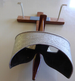 Warrnambool and District Historical Society Inc.
Functional object - Steroscope, Underwood & Underwood, Circa 1900
Underwood and Underwood commenced manufacturing stereoscopes and cards in the 1880’s, and by 1900 they were selling 300,000 stereoscopes a year and producing 25,000 cards a day. A large volume of their photographic work survives to this day.A popular item which was in common use around 1900. The cards used, provide a useful view of people and places around that time. They were pioneers in the field of news photography. Many of their images are still available today.Metal viewing section with glass inserts with wooden extension with a sliding viewing section with metal brackets. Metal part has figured marking around top. It has a fold down wooden handle with metal hinge.Manuf’d Underwood & Underwood Patented June 11 1901Foreign patents applied for.warrnambool, stereoscope, underwood & underwood -
 Wodonga & District Historical Society Inc
Domestic object - Meat Safe known as a "Coolgardie Safe", Early 1900s
The Coolgardie safe was invented in the late 1890s on the Western Australian goldfields. Its invention was credited to a local contractor named Arthur Patrick McCormick. It was a practical system to preserve food prior to modern refrigeration. The wire grid kept the food safe from vermin and allowed breeze to blow through. It was often covered with wet hessian so that as the breeze circulated the water evaporated, creating the same concept as coolant in modern refrigerators and ice boxes. In most respects it was a variation of the bushman’s hessian bag hanging in a tree. In larger towns and cities during this time period large "ice works" could deliver block ice to areas that required a form of refrigeration. These ice blocks where held in early refrigerators to keep perishables cool. In isolated or rural households, the Coolgardie or meat safe was the next best, practical solution for food preservation. This safe was used in the home of the Conway family in Wodonga.This item is very significant to the Wodonga region as it represents the initiative and problem solving skills of the early settlers. It also reflects the primitive conditions in which they lived before the arrival of more modern services such as electricity.Meat safe or Coolgardie safe manufactured in Australia. This safe is made from metal and has been painted in green paint. 2 sides of the safe have a pattern of 6 squares of holes to allow for ventilation and air flow. The holes would also guard against insects and other vermin. There is one shelf inside, dividing it into 2 sections. The safe has a hook attached so that it can be suspended, often from a tree or on a verandah to increase air flow. The safe would often be covered by wet hessian to promote further cooling and preservation of foods such as milk, butter and meat.coolgardie safe, food preservation, pioneers innovation -
 Bendigo Historical Society Inc.
Document - VICTORIA HILL - SPECIAL FEATURES
Four hand written pages and typed copy, titled The Victoria Hill - Special Features. Notes mention the Victoria Hill, the deepest workings on the field,the first mine on the field to 2,000 and 3,000 feet in depth, Ballerstedt's Open-Cut, Rae;s Open-Cut, Wittscheibe's Jeweller's Shop, the Adventure, the richest cross-section of the whole of the Bendigo Goldfield, the first mine to pay dividends from ore mined below 1,000 feet to 1,500 feet from the surface, the tallest poppet legs on the field, Lazarus Mine, Barnet Lazarus, Mt Alvernia Hospital, Central Red White & Blue. Notes prepared by Albert Richardson.document, gold, victoria hill, victoria hill, victoria hill - special features, john neill macartney, the argus, the australasian, bendigo goldfields registry, victoria reef quartz mine, the deepest workings on the field, the first mine on the field to reach 2, 000 and 3, 000 feet in depth, lansell's 'big 180' mine, hot water, george lansell, theodore ballerstedt, fortuna, ballerstedt's open-cut, rae's open-cut, wittscheibe's jeweller's shop, adventure, advance, cinderella, the private pioneer coy, new chum & victoria mine, a h q survey regiment, tallest poppet legs, lazarus mine, barnet lazarus, mt alvernia hospital, central redwhite and blue, hudson's, burrowes & sterry, b c v 8 television station, swan hill's channel 11 -
 Greensborough Historical Society
Article, Origins of the name "Greensborough", 1913_
From an article on Victorian pioneers and their services to the state. This section describes the life of Mr Edward Bernard Green after whom Greensborough was named.Gives the origins of the name Greensborough and an outline of the life of the man behind the name, E.B.Green.2 x A4 pages downloaded from Victorian Historical Magazine (1913) Vol 3, Issue 10, pages 79-80.Cover sheet: Greensborough. Origins of the name 'Greensborough". Source: Victorian Historical Magazine (1913) Vol 3, Issue 10, pages 79-80.edward bernard green, greensborough, origins of name -
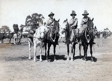 8th/13th Victorian Mounted Rifles Regimental Collection
Photograph - 20 LH Hotchkiss MG Section
A Hotchkiss Light Machine Gun provided automatic fire support to the Troop. In action a crew of two men manned the gun while the third man took the horses to cover. The 20th Light Horse (Victorian Mounted Rifles) was raised in 1920 as part of the 3rd Cavalry Brigade, 2nd Cavalry Division, Citizen Military Forces, with Headquarters at Seymour and depots along the Goulburn Valley from Mansfield to Tocumwal in southern NSW. In December 1941, 20th Light Horse (Victorian Mounted Rifles) converted from horse to mechanised, initially as 20th Motor Regiment. In 1943 the Regiment was deployed to Merauke, Dutch New Guinea. Upon its return in April 1945, the Regiment was redesignated 20th Pioneer Battalion. It was disbanded following the end of the war. 20th Light Horse was the only light horse regiment to serve overseas in WWII.This is one of a collection of photographs featuring a Light Horse regiment drawn from rural and regional Victoria in the period immediately prior to mobilisation for World War 2 (1939-1945).Black and white photograph mounted on card of three soldiers on horses, one leading a pack horse, being a Hotchkiss Automatic Rifle Section in 20th Light Horse Regiment , circa 1939.20th, light horse, hotchkiss, seymour -
 Bendigo Historical Society Inc.
Document - BENDIGO CEMETERIES COLLECTION: SELF GUIDED TOUR BENDIGO CEMETERY DOCUMENT
BHS CollectionYellow trifold document: Self Guided tour of the Bendigo Cemetery, 145 Years of History 1858 - 1993. Document contains a map of a section of the Bendigo Cemetery, 29 graves are numbered and described. E.g. J.C.T. Ballerstedt, Quartz Reefer, Robert Clark 8 hour day pioneer, Giuseppe Favaloro restaurateur. Hitching rail outside cemetery gates is noted.bendigo, cemetery, bendigo cemetery tour -
 Bendigo Historical Society Inc.
Document - GARDEN GULLY LINE OF REEF, LEASE BLOCKS 5360 AND 5361
Two page document titled ' Report on lease blocks Nos. 5360 and 5361 Garden Gully line of reef, Bendigo. Produced by the Department of Mines 1899. The area described is about 'one mile and a quarter southeast from the centre of the city of Bendigo, immediately south of the Great Southern Gold Mining Company's workings and is intersected by two auriferous gullies ... Salomon's Gully and Derwenter's Gully'. The alluvial deposits, the Garden Gully line, the Great Souther Co.and old workings are discussed in the paper. A map of the Garden Gully line of reef is attached to the report, showing claimholders and mine names along that section of the reef. Mines named on the map: Great Southern Garden Gully United Ulster Londonderry Burrows Horwoods Sea Amalgamated Garden Gully United Victory and Pandora Unity Carlisle and Garden Gully and Passbye United Cornish United Koch's PioneerJames Stirling, Government Geologistbendigo, mining, garden gully line of reef mines -
 Stawell Historical Society Inc
Map, Underground Survey of the Principal Mines of Stawell 1879, 1879
Pleasant Creek & Newington, Prince Patrick, Prince Alfred, Pioneer and Galatea, Pleasant Creek Cross Reef No. 1&2, Magdala, Old Shaft, Extended Cross Reef, Crown Cross, Great Northern, Sloanes & Scotchmans, South Cross, 10 & 11 United Scotchmans South Cross, Scotchmans Shafts, North Scothmans, West Scotchmans, Emerald Isle & Rose of Denmark, Albion, South Scotchmans, Newington & Pleasant Creek, Pleasant Creek Cross Reef, Moonlight, Extended Cross Reef, Crown cross United, Great Northern ShaftVery large Map on cloth backing, showing cross sections of mines.Surveyed by H.C. Bates. Drawn by Arthur Edwards. October 30th 1879. Scales 120 feet to an inchmining, gold -
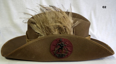 Bendigo Military Museum
Headwear - HAT, SLOUCH, WWI c.1914
Ernest OLD. Records show that he enlisted for the Boer War No 2356 on 11.7.1902 in the 2nd Australian Commonwealth Horse age 27 years. On 10.8.1912 he enlisted in the 17th Aust Light Horse No 84004 D Troop A Sqd. He then enlisted in the AIF No 77, 13th LH, HQ & Machine Gun Section aged 40 years on 22.12.1914. Embarked for Eygpt 28.5.1915. Embarked for Gallipoli 4.9.1915. Hospitalised 24.12.1915 with Parotitis / Mumps. Hospitalised 23.1.1916 with Debility. Transferred to 2nd Pioneers 14.3.1916. Embark for France 19.3.1916. WIA 14.11.1916 GSW thighs severe. Medically downgraded to C3. Returned to Aust 20.12.1917 re wounds and overage. Discharged from the AIF 27.3.1918. He then went back into 17th LH until 1933 with the rank WO 2 in Stores.Australian Lighthorseman Slouch Hat with pugaree, emu plume, badge & leather chin strap with metal buckle. The badge has the devil above a half wreath of leaves on a round red Petersham On Badge: "13/ALH" Handwritten inside crown: E. Old 7' (Size) Adelaide HATS COY 1028armed forces, military uniform, costume, hats, australia, male -
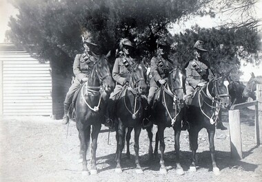 8th/13th Victorian Mounted Rifles Regimental Collection
Photograph - 20th Light Horse section
A section of four riflemen was the basic element of a Light Horse unit. In action when forced to dismount, three men formed the firing group while one man took the horses to cover.The 20th Light Horse (Victorian Mounted Rifles) was raised in 1920 as part of the 3rd Cavalry Brigade, 2nd Cavalry Division, Citizen Military Forces, with Headquarters at Seymour and depots along the Goulburn Valley from Mansfield to Tocumwal in southern NSW. In December 1941, 20th Light Horse (Victorian Mounted Rifles) converted from horse to mechanised, initially as 20th Motor Regiment. In 1943 redesignated 20th Pioneer Battalion and deployed to Merauke, Dutch New Guinea. The regiment was disbanded at the end of the war, 1945. 20th Light Horse was the only light horse unit to serve overseas in WWII.This is one of a collection of photographs featuring a Light Horse regiment drawn from rural and regional Victoria in the period immediately prior to mobilisation for World War 2 (1939-1945).Black and white photograph mounted on card of four mounted horsemen being a section of the 20th Light Horse Regiment circa 1939. A fine image but the keen eyed observer will note the negative has been reversed in the processing. -
 Eltham District Historical Society Inc
Magazine - Magazine Article, Sweeneys; a home with a history, Nora Cooper, The Australian Home Beautiful; Vol. 18, No. 2, February 1, 1940, 1940
Article - "A home with a history" by Nora Cooper featuring Sweeney's Cottage at Culla Hill in Eltham, a pioneer settler of the district on pages 6-9 and 49-50Magazine missing cover (pages 1, 2, 51,52); p49/50 torn, several articles where pictures have been cut out or sectioned Dispay panel of a second copy of article pages adhered to boardaustralian home beautiful magazine, culla hill, eltham, houses, sweeney's cottage, sweeneys lane, thomas sweeney, display panel -
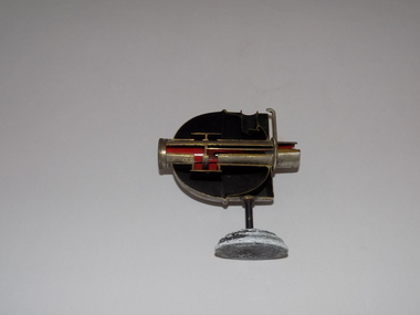 Geoffrey Kaye Museum of Anaesthetic History
Equipment - Inhaler, Clover (sectioned)
Dr. Joseph Clover (1825-1882), an English physician, first described his Portable Regulating Ether Inhaler on Jan. 20, 1877. Clover was an especially sought after anesthesiologist and early pioneer in the specialty. This was the best-known of many inhalers that Clover designed. The dome-shaped reservoir was turned to points on a control dial to gradually increase or decrease the percentage of the air that passed over the ether. Several inventors based new inhalers on this, while the original continued to be manufactured as late as the beginning of WWII. Dr Geoffrey Kaye sectioned equipment, enabling medical students to see the inner workings and gain insight into the engineering of the equipment.Cross section of Clover's inhaler attached to a circular metal base.Handwritten on white sticker at rear: P / 26 / B •White print on blue sticker: O.2.3. •Engraved on dome side of inhaler: G. Kaye sect. 1939.joseph clover, geoffrey kaye