Showing 1655 items matching "junctions"
-
 Melbourne Tram Museum
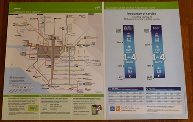
Poster, Yarra Trams, "Melbourne Tram Network" and "Swanston St and St Kilda Road Trams", Apr. 2011
Full colour poster printed on a vinyl plasticized based sheet, titled "Melbourne Tram Network" - showing a diagrammatic layout of Melbourne tram routes, Myki ticket notes and where tickets can be obtained, information numbers (PTV, phone applications) and information on Tram Tracker, twitter and other contact systems on the left side and on the right side titled "Swanston St and St Kilda Road Trams" showing the frequency of service from Stop 1 to Stop 30 - Melbourne University to St Kilda Junction. Has a table showing the first and last trams to each of the routes for Monday to Thursday, Friday, Saturday and Sunday. On the base has notes regarding accessible services. Map shown as effective April 2011. Has the document information on the right hand side of the poster.trams, tramways, yarra trams, ptv, maps, tramtracker, myki, swanston st, st kilda rd -
 Wodonga & District Historical Society Inc
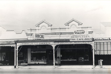
Photograph - Mann Collection Album - High Street East - J. McSwinney & Co, 1960s
Elaine Mann was married to David Mann, a successful Wodonga businessman and community leader who passed away in Wodonga in June 2012. David was a member of the Mann family who began their business in Wodonga in 1920. Elaine was a teacher in Wodonga for many years and an active member of the community.This photo collection is of significance as it documents how the businesses and buildings in Wodonga have evolved and contributed to community throughout the late 20th centuryBusinesses from Left to right J. McSwiney & Co Chemist, Dempster’s Café and Pilkington’s Shoes. This building is still standing and now includes business High Exposure, Junction Pizza, Greg’s Takeaway and Barbers Quarter Haircuts and Shaves. Born in Chiltern in 1875, John T McSwiney moved into his premises in High Street, Wodonga in 1901. He operated his pharmacy from this site for over 64 years. At its peak, John put the Wodonga store under the care of a manager and moved to set up a second pharmacy in Wangaratta. He later returned to his Wodonga pharmacy where although semi-retired John continued to go to work each day up to his 90th birthday. His chemist shop was sold about 1967.wodonga businesses, high st wodonga, pilkingtons, mcswiney chemist -
 Bendigo Historical Society Inc.
Postcard - Australia, Elliot Collection, 1895 - 1914
Thought to have originated in Austria in 1869, postcards first gained popularity in Australia in the 1890s.They were used to send short messages to friends and family. This collection was generated by Mary Emma Elliot of Talgarno. Talgarno is a rural locality in Victoria, Australia, situated on the southern shoreline of Lake Hume, about 23 km east of Albury-Wodonga. The collection contains postcards from across the world. Mary Emma Sibley was born in Ironbark, Bendigo in 1859. She married James Elliot in 1893 and they settled at “Kelso”, Talgarno. They had two children – Mona and Sibley. Mary Emma Elliot died in Melbourne in 1944, aged 84 years. Australian postcards collected by Mrs. James Elliot between 1898 and 1915. 1405.341 Winter Scene 1405.342 A Vase of Flowers 1405.343 On the Road 1405.344 Artist's Glen, Lorne, Victoria 1405.345 Knight of the Bath 1405.346 Off on the Wallaby Track 1405.347 Washing-day in Camp 1405.348 Woman and Child 1405.349 A breezy day on a Rocky Coast 1405.350 Allan's Music Shop 1405.351 Rocky Headlands, near Cowes, Phillip Island 1405.352 Birthday Card 1405.353 On the Buffalo River 1405.354 Jack's Creek Aqueduct, Whittlesea 1405.355 River Yarra, Yarra Junction 1405.356 Shire Hall, Warragul 1405.357 Mentone 1405.358 Holiday Resort, Lorne, Vic 1405.359 Botannical Gardens, Ballarat 1405.360 Snow Scene, Ballarat Gardens. 1905 postcards, collecting, collections, talgarno -
 Ballarat Tramway Museum
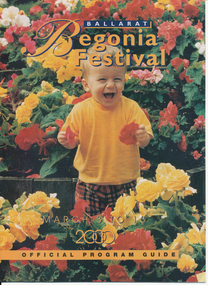
Memorabilia - Event Materials, The Courier Ballarat, "Ballarat Begonia Festival - Official Program Guide", 31/03/2000 12:00:00 AM
Forty page full colour printed program for the 2000 Begonia Festival. Includes festival events, maps, details of related events. On page 38 is an half page item on the Ballarat Tramway Museum. First photo features Stephen Butler in the cab of tramcar, with another tramcar (40) in the background - taken at depot junction, some details on the Ballarat Tramway system and details of the BTM itself. A second photograph features four trams at the Loop (40, 671, 13 and 26) during Boxing Day 1999. Details of the program production on page 3. Images items include reproductions of each photograph and the general layout of the item itself. See 1347i4 for image of the front cover. See also Reg Item 5466.1 to 5466.3 for other year 2000 brochures.trams, tramways, btm, begonia festival, festival program -
 Ballarat Tramway Museum
Photograph - Digital image Set of 10, Tony Smith, 1971
Yields information about Ballarat Tramways and trams prior to the closure of the tramway system.Set of 10 digital images of Ballarat trams prior to closure, scanned from original slides by Tony Smith, 1971 prior to closure of the system. .1 - 37 at the Lydiard St North terminus, with the shelter in the background. .2 - 33 at the Mount Pleasant terminus, has the corner store with a "The Sun" advertisement and the general store on the right side of the road in the background. Has signs for Streets Ice Cream and Coca Cola. Also has the tram stop signs - painted pole and enamel sign. .3 -33 arriving at the Mt Pleasant terminus with the conductor stepping off the back step, a lady walking across to the tram. Tram has a Twin Lakes sign. .4 - 11 at Victoria St terminus, with conductor turning the pole. Tram has a Twin Lakes sign. IN the background is the rail bridge over the Eureka line and a shelter. .5 - 11 in bound from Victoria St, shows the bleakness of the street at the time. Tram has Twin Lakes and a SEC Briquettes signs. .6 - 12 outbound to Mt Pleasant in Main St and the corner with Humffray St. Tram has a Twin Lakes sign. .7 - 11 in bound from Victoria St, in Bridge St, with junction in background. Tram has Twin Lakes and a SEC Briquettes signs. In the background are Rodda's, C.W. Pennant wall papers and Gill and O'Keffe footwear stores. .8 - 21 in Wendouree Parade, in bound to Victoria St, with the Lake in the background, near Macarthur St. .9 - 21 ditto, nearing the Macarthur St junction. Has the shelter and tram stop signage for View Point in the background. .10 - 34 sitting on the depot fan, 2 road, ready to run out. Has Mt Pleasant as the destination.trams, tramways, lydiard st north, mount pleasant terminus, victoria st, main st, bridge st, wendouree parade, macarthur st, view point, depot, tram 37, tram 33, tram 11, tram 12, tram 21, tram 34 -
 Orbost & District Historical Society
photograph, 1937
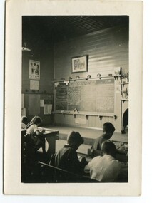
In 1912 the school at Pumpkin Point opened to serve the children of farmers living in the Bete Bolong district. This meant a big change in their way of life because in the past the children had been rowed across the Snowy River each day to attend school at Jarrahmond. Myrtle Bunting was the first HT of the school which had been erected on a block of land purchased from H. Richardson. The school functioned until 1952 when a shortage of pupils caused its closure. As a bus service to Orbost now operated, the school at Pumpkin Point faced permanent closure. J. McKeown bought the building. Students attending the school at this time included Russells, Johnstones, Reeves, Healeys, Kavanaghs, Phillips, Rodwells, Mills, Baileys, Gilberts and Masons. Mr. Oswald S. Green taught at Bete Bolong State School until he was appointed to Rokewood Junction in August 1937.This item is associated with the history of education in the Orbost district. There is no longer a school at Bete Bolong.A small black / white photograph of students sitting in a classroom.on back - "Bete Bolong School, 1937. O.S. Green was H.T."bete-bolong-school pumpkin-point green-o.s. -
 Orbost & District Historical Society
photograph, 1937
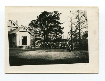
In 1912 the school at Pumpkin Point opened to serve the children of farmers living in the Bete Bolong district. This meant a big change in their way of life because in the past the children had been rowed across the Snowy River each day to attend school at Jarrahmond. Myrtle Bunting was the first HT of the school which had been erected on a block of land purchased from H. Richardson. The school functioned until 1952 when a shortage of pupils caused its closure. As a bus service to Orbost now operated, the school at Pumpkin Point faced permanent closure. J. McKeown bought the building. Students attending the school at this time included Russells, Johnstones, Reeves, Healeys, Kavanaghs, Phillips, Rodwells, Mills, Baileys, Gilberts and Masons. Mr. Oswald S. Green taught at Bete Bolong State School until he was appointed to Rokewood Junction in August 1937. This photograph is associated with the history of education in the Orbost district. There is no longer a school at Bete Bolong.A small black / white photograph of students and teachers standing outside a school.on back - " Bete Bolong School , 1937"bete-bolong-state-school education-orbost -
 Ballarat Heritage Services
Photograph - Image, Guildford, Victoria, 1867
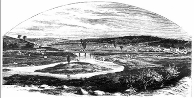
Black and white image of Guildford, near Castlemaine, VictoriaGUILDFORD Is a small township situated at the junction of Campbell's Creek and the Loddon. It is about seven miles from Castlemaine, on the road from that town to Ballaarat and Daylesford. The land near the Loddon is very rich, and as a large number both of theoretical and practical miners believe that a rich goldfield underlies the surface basalt, there is every probability of Guildford being ere an important goldfield. A large area of land in the neighbourhood has been already worked, principaIy by Chinamen, who until very recently mustered in great force in the locality. (Illustrated Adelaide Post, 23 March 1867)guildford, loddon river -
 Tatura Irrigation & Wartime Camps Museum
Photograph, Daryl Walker, Halsey's Store, 1966
Byrneside Post Office and general store built to replace first store, burned in 1902. Conducted by A. W. Halsey 1936-1974. This store also burned down January 1979. Owners A. & C. Golightly. A new modern store was rebuilt. A store which also served as Post Office was operating when the district was known as the Junction, the name being changed to Baldwinsville in 1880 and Byrneside in 18985. It was established by John Morrissy, a local teacher. This store was burned to the ground in 1902. The storekeeper at that time was Stephen O'Toole. Other owners were W. Sheales, Buckley Bros., J. Taylor, L. Martin, A. Fleming, L. Halfpenny and A. W. Halsey conducted the business from 1936 till Mr Golightly took over in 1974. From 1926 to 1966 the storekeeper was also in charge of the telephone exchange. For a number of years the beautiful gardens was the venue for the annual cup day garden party run by the Byrneside Red CrossBlack and white photograph of Halsey's store, Byrneside, exterior.on back: Per courtesy of Ian Lynch, Tatura, Tatura and District Historical Societybyrnside post office, byrnside general store, a. w halsey, a. & c. golightly, annual cup day, byrneside red cross, stephen o'toole, w. sheales, buckley bros., j. taylor, l. martin, a. fleming, l. halfpenny -
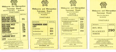 Melbourne Tram Museum
Ephemera - Timetable/s, Melbourne & Metropolitan Tramways Board (MMTB), "MMTB Bus Timetables", 1981
Timetables for specific routes, day of week giving information on tram times at specific time points, route map, sections and fares and organisation address - 616 Little Collins St. Melbourne. All printed on yellow paper unless noted otherwise. .1 - Route 215, 216, 217, 219, 229, 218 - Deer Park, Sunshine, Footscray, City - November 1981 .2 - Route 233, 235 and 237 - Fisherman's Bend - City November 1981 .3 - Route 256, 251, 253, 254, 252, 255 - Latrobe University, Northland, West Heidelberg, North Carlton - City - April 1981 .4 - Route 290 - Box Hill - Blackburn North - March 1981 5 - Williamstown Road, Footscray, Ballarat Rd and Highpoint West - Route 223 - April 1981 6 - Clifton Hill, Esternwick, Point Ormond, St Kilda Junction - routes 246, 247 and 248 - Feb. 1981Yields information about MMTB bus services 1981.Set of 6 MMTB Bus timetables, folded sheets, generally 10 sections.trams, tramways, mmtb, timetables, melbourne, fares, buses, deer park, sunshine, footscray, fisherman's bend, latrobe university, northland, heidelberg, carlton, box hill, blackburn, ballarat road, williamstown road, highpoint, clifton hill, elsternwick, point ormond -
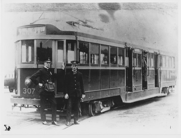 Melbourne Tram Museum
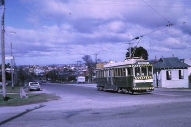
Photograph - W class 307 and crew, 1924-1928
Photograph shows W class 307 standing on slightly curved track displaying destination "Victoria Bridge" and no route number box attached. The uniformed motorman and conductor stand on the roadway next to the front driver's cab where the trolley pole has been tied down. The conductor wears his coin bag and the driver is holding the tram's key and air brake handle. An elderly male passenger with coat stands at the drop-centre doorway and other passengers are inside. The car body of W 307 was built by Holden Motor Body Builders in South Australia in 1924 as part of a large contract to build W class trams. Victoria Bridge was the termini of both the Collins Street and Victoria Parade cable tram that closed in 1929 and the Mont Albert electric tram from Union Road, via Whitehorse Road and Kew Junction. Perhaps this photograph is of the Mont Albert terminus although the curved track suggests otherwise.Yields information about early W class tramcars . Black and white photograph with penciled dates on rearPencil writing reads "Between 2/9/24 & 19/3/28" trolley pole, drop-centre, w class, tram 307, victoria bridge, route number box, key, air brake handle, car body, holden motor body builders, mont albert, termini -
 Kiewa Valley Historical Society
Book - Non Fiction History, The Kiewa Story, circa 1993
This book provides in chronological order the development of the Kiewa Hydro-electricity scheme from the first concept (1911) to final construction work (1961). It covers the first attempt to utilise the power of the Victorian Alps water system. It started from a private syndicate and developed to the current State Electricity Commission of Victoria. The incentive for the Hydro scheme was to make money and not as an alternative to the carbon producing coal fired power plants. These coal fired power plants were increasing in numbers to service an ever increasing demand made by population expansion, especially in cities and large rural settlements. This demand spiraled up after World War II when there was a tremendous spike in immigration numbers due to refugees and displaced persons in Europe. The ability to utilise the untapped water provided by the winter snow fields, for a higher yield in electricity, was a powerful incentive to overcome the physical hardships in this remote Alpine region. Future power requirements may initiate the re-installation of the other two power stations(Pretty Valley and Big Hill) covered in original Scheme. This publication not only covers the development of the Kiewa Valley region with respect to population (within a socio-economical framework) but also the subtle but yet strong physical changes of a relatively pristine alpine region. The demands that an ever growing regional population places on the environment is clearly documented in print and black and white photographs. The working and living conditions of those who constructed and gave life to this hydro scheme is well documented in this book. It may be viewed as spartan now but was relevantly good at that moment in time, especially for those workers fleeing a devastated European environment. The successful planning and consideration to minimising any intrusion upon the natural alpine forests and high plains can viewed as an example (compared to the Tasmanian Hydro schemes) of how future hydro schemes (an inevitable requirement) will proceed. Most rural towns (in the early 1900s) were built by unencumbered rural based citizens, with the exception of Mount Beauty and Falls Creek. These two settlements were brought into life by a State (Victorian) Authority for a specific function and program. They were a gated community, that is, only open to construction workers involved with the hydro scheme. All facilities within these communities were provided by the State Electricity Commission of Victoria. The impact on the social, financial and individual independency of the community, by the transition from the S.E.C .environment to one of local government (Shire of Bright), had in some cases a severe impact.This hard covered book has a green cover with pictures on the front and back covers. The front cover has a coloured picture of a snow covered Mount Bogong taken from the opposite mountain range. The valley between both ranges has a whisk of mist over it. At the bottom of this picture are three black and white photographs covering the construction of the Kiewa Hydro - Electricity Scheme. On the back cover is a photograph, (black and white) detailing the Bogong village and Junction dam containing lake Guy. The inside front cover is a black and white photograph which details the construction of the West Kiewa tailrace tunnel during April 1951. The inside back cover is a black and white photograph of the concrete pour at the Clover Dam circa 1952. All photographs and sketches are in black and white. The pages are approximately 160 g/m2 and those which have photographs are on gloss paper.Book spine: "The Kiewa Story Graham Napier Geoff Easdown" alongside this is a white framed circle with white spokes radiating out and underneath in white lettering SECkiewa valley, hydro scheme, victorian alpine region, electricity generators, graham napier, geoff easdown -
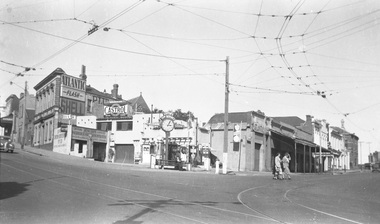 Ballarat Tramway Museum
Photograph - B&W print of donated negative, Ron E. Fluck, 23/04/1950 12:00:00 AM
Black and white print of a donated negative. Print made 8/1998. Photo of the Lister's Junction Service Station, overhead and tram track at the intersection of Bridge St, Main St and Victoria St. (Stones Corner). Shows the style of overhead construction, signal contactors, the service station, its clock and associated advertising. Three ladies are crossing the road. Photo taken on 23.4.1950 at 3.05pm. Advertising on service station has Atlantic, Shell, and Castrol. Has multiple petrol dispensing bowsers. Clocks has directional arrows for Melbourne and Geelong. Tram tracks visible. Copy made Oct. 2001 for the "gold, Gold GOLD" temporary exhibition - colour laser print onto card, with Velcro dots on rear. Stored in box D1 (Display Box) 02/2003. high res scan of the negatives added 18/1/2019.tramways, trams, bridge st, stones corner, ballarat, main st -
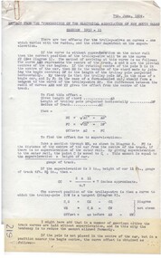 Ballarat Tramway Museum
Manual - Procedure, State Electricity Commission of Victoria (SECV), "Extract from the 'Proceedings of the Electrical Association of New South Wales' session 1910 - 11", mid 1930's
Two copies of a Carbon typed copy of a technical procedure - 6 pages - "Extract from the 'Proceedings of the Electrical Association of New South Wales' session 1910 - 11" - giving advice on the location of Trolley Wire" giving the guide on how to locate trolley wire on curves and junctions, gives formulas, positioning at frogs, notes regarding various cars and trolley wire height includes notes on cross falls of track, a table of aluminium copper alloys - bending strength and failure modes. Consists of five pages with two blue print drawing. Each page has been scanned the blue print drawings reversed imaged as well. 4768.2 - blue print drawing showing references in the various formulas etc used. 4768.3 - ditto showing tracking for four wheeled and bogie cars and other diagrams for turnouts, frog locations and frog angles. BTPS Number "219". "226" in ink on left hand bottom of first pagetrams, tramways, overhead, trolley wire, points -
 Ballarat Tramway Museum
Slide - 35mm slide/s - set of 11, Eldon Hogan, mid 1960's to early 1970's
Set of 11 Agfa Plastic mounted slides - from the Eldon Hogan collection - featuring an ARE tour with Nos. 21, 29 and 25 to Bendigo, mid 1960's. Scanned on the Canon scanner at the depot 15/12/1971 at the time of the installation of the scanner. .1 - No. 29 passing the Institute of Technology building, McCrae St. .2 - ditto .3 - Nos. 21 and 29 Lake Weeroona .4 - Nos. 29, 21 and 25 at the Golden Square Terminus with the Golden Square Hotel, Victoria Bitter fence in the background. .5 - ditto with a service car? .6 - ditto .7 - No. 21 with the Central Deborah mine poppet head in the background, Violet St. .8 - ditto with 21 and 29 .9 - ditto with 29 .10 - ditto with 21 and 29 .11 - 21, 29 and 25? at depot junction. Trams have SEC roof advertisements. tramways, trams, bendigo, lake weeroona, golden square, central deborah, tram 21, tram 29, tram 25 -
 Ballarat Tramway Museum
Photograph - Colour Print/s - set of 15, Earl Ewers, 25/09/2005 12:00:00 AM
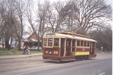
Yields information about the centenary celebrations of electric trams in Ballarat in 2005 and some of the people involved.Set of 15 colour prints of Ballarat Horse Tram No. 1 and Bendigo 17 in Wendouree Parade and St Aidans Drive during the celebrations for the centenary of electric trams in Ballarat - 25/9/2005. .1 - No. 26 at the loop .2 - No. 1 at the loop .3 - 26 and 1 at loop .4 - 1, ? and 17 at loop with lots of people .5 - 1 leaving the loop .6 - 1, 17 and 28 at loop .7 - ditto .8 - 28 and 1 at loop - Roger Salen and Austin Brehaut .9 - 1 arriving at the loop from Depot Junction .10 - 1 at loop - side on view .11 - 1 at loop - Alan Bradley and friends. .12 - 1 at loop .13 - ditto .14 - 17 and 28 at loop .15 - 1 at loop - Alan Bradley and friends. Printed on Kodak Royal Paper. Earl Ewers photograph. trams, tramways, bendigo, centenary, wendouree parade, btm, tram 17, tram 1, tram 26, tram 28 -
 Ballarat Tramway Museum
Photograph - Black and White photocopy, Travis Jeffrey, 1961
Negative No. N387 and black and white print made by a laser printer (stored in folder) of Ballarat No. 39 passing depot junction, in 1961. Tram fitted with lights and small white stripe. Small triangles in corners of front dash. Ad for 60/40 dancing at Civil hall on front of tram. Showing Victoria Street destination. Lake in background, no other vehicles. Photo by Travis Jeffrey, who advised could be Dave Kellett driving. Date of photo on folder 5/9/1960. Date of photo could be incorrect, due to fitting of lights taking place late 1960. Large print of this photo made for display 1995c. Item updated when negative added to collection - 1/6/2003. Original negative rescanned 24/5/2020 and image file updated. Paper print of original photo in folder 73.Paper folder that contained the negative had "NR40A" in red ink, "BA14" in pencil, date stamp of "5 Sep 1960" on front, and on rear date stamps "26 Sep 1962" and "6 Oct 1962".trams, tramways, ballarat, wendouree parade, tram 39 -
 Kew Historical Society Inc
Photograph, J F C Farquhar, The Post Office, 1891
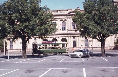
At the beginning of the 1890s, the Kew businessman and Town Councillor, Henry Kellett, commissioned J.F.C. Farquhar to photograph scenes of Kew. These scenes included panoramas as well as pastoral scenes. The resulting set of twelve photographs was assembled in an album, Kew Where We Live, from which customers could select images for purchase.The preamble to the album describes that the photographs used the ‘argentic bromide’ process, now more commonly known as the gelatine silver process. This form of dry plate photography allowed for the negatives to be kept for weeks before processing, hence its value in landscape photography. The resulting images were considered to be finely grained and everlasting. Evidence of the success of Henry Kellett’s venture can be seen today, in that some of the photographs are held in national collections.It is believed that the Kew Historical Society’s copy of the Kellett album is unique and that the photographs in the book were the first copies taken from the original plates. It is the first and most important series of images produced about Kew. The individual images have proved essential in identifying buildings and places of heritage value in the district.A panoramic photograph of the junction of High Street and Cotham Road. The photographer centres the point-of-view on the Kew Post Office and adjacent Court House. These were designed in the Queen Anne style by the Public Works Department's architect J Harvey and completed in 1888. The complex is important because it demonstrates a departure from the contemporaneously favoured High Victorian Classical to the Queen Anne style in the design of civic buildings. The earlier Jubilee Fountain in front of the Post Office was erected by the Kew Borough Council to commemorate the Golden Jubilee of Queen Victoria in 1887. It was created to a design of the architects Reed, Henderson and Smart. The fountain was later relocated to the Alexandra Gardens to make way for the Kew War Memorial. The tram tracks in High Street were used by the horse tram, which ran from the Victoria Street Bridge to the Boroondara General Cemetery. The tram was replaced by an electrified service in 1915.The Post Officekew post office, kew illustrated, kew where we live, photographic books, henry kellett -
 Kew Historical Society Inc
Photograph, J F C Farquhar, Studley Park Road, 1891
At the beginning of the 1890s, the Kew businessman and Town Councillor, Henry Kellett, commissioned J.F.C. Farquhar to photograph scenes of Kew. These scenes included panoramas as well as pastoral scenes. The resulting set of twelve photographs was assembled in an album, Kew Where We Live, from which customers could select images for purchase.The preamble to the album describes that the photographs used the ‘argentic bromide’ process, now more commonly known as the gelatine silver process. This form of dry plate photography allowed for the negatives to be kept for weeks before processing, hence its value in landscape photography. The resulting images were considered to be finely grained and everlasting. Evidence of the success of Henry Kellett’s venture can be seen today, in that some of the photographs are held in national collections.It is believed that the Kew Historical Society’s copy of the Kellett album is unique and that the photographs in the book were the first copies taken from the original plates. It is the first and most important series of images produced about Kew. The individual images have proved essential in identifying buildings and places of heritage value in the district.In this view of Studley Park Road, looking northeast to the Junction, the photographer invites the viewer to participate in a point-of-view that emphasises the elevated, tranquil vantage point of the hill in contrast to the bustling commercial area in the distance. The view emphasises the exclusiveness of Studley Park, with its high fences behind which a number of significant Kew mansions were concealed. Contemporary advertisements for the sale of mansions in Studley Park Road often included fulsome descriptions of their elaborate formal gardens, as well as paddocks for grazing, stabling and dairies. None can be seen here. The use of high, protective wooden pickets to surround the newly planted avenue of elms on the south side of the road appears to be typical of the period. Similar examples can be seen in early photographs of Wellington and Princess Streets.The horse and carriage, selected as a central focus of the view, reinforces the residential, exclusive nature of this part of Kew in the early 1890s. Studley Park Roadkew illustrated, kew where we live, photographic books, henry kellett -
 Kew Historical Society Inc
Plan - Subdivision Plan, J R Mathers & McMillan, Glenarbor Estate, 1934
Pru Sanderson, in her groundbreaking ‘City of Kew Urban Conservation Study : Volume 2 - Development History’ (1988), summarised the periods of urban development and subdivisions of land in Kew. The periods that she identified included 1845-1880, 1880-1893, 1893-1921, 1921-1933, 1933-1943, and Post-War Development. These periods were selected as they represented periods of rapid growth or decline in urban development. An obvious starting point for Sanderson’s groupings involved population growth and the associated economic cycles. These cycles also highlighted urban expansion onto land that was predominantly rural, although in other cases it represented the decline and breakup of large estates. A number of the plans in the Kew Historical Society’s collection can also be found in other collections, such as those of the State Library of Victoria and the Boroondara Library Service. A number are however unique to the collection.The Kew Historical Society collection includes almost 100 subdivision plans pertaining to suburbs of the City of Melbourne. Most of these are of Kew, Kew East or Studley Park, although a smaller number are plans of Camberwell, Deepdene, Balwyn and Hawthorn. It is believed that the majority of the plans were gifted to the Society by persons connected with the real estate firm - J. R. Mathers and McMillan, 136 Cotham Road, Kew. The Plans in the collection are rarely in pristine form, being working plans on which the agent would write notes and record lots sold and the prices of these. The subdivision plans are historically significant examples of the growth of urban Melbourne from the beginning of the 20th Century up until the 1980s. A number of the plans are double-sided and often include a photograph on the reverse. A number of the latter are by noted photographers such as J.E. Barnes.The little-known Glenarbor Estate comprised 23 allotments bordering Wellington and Denmark Streets and Fenton Avenue. The auction of the allotments in the Estate was held in the Kew Recreation Hall. The purported advantages to Kew are identified on the plan, such as the close proximity of the entrance to the Kew Railway Station and access to shops in Denmark Street. Due to its location, the subdivision was pitched at commercial as well as residential purchasers. The Estate was to cause a crisis in the Kew Council as a majority of councillors voted on 29 May to acquire the entire Estate as the location of a new Town Hall. The Estate was said to be valued at £50,000. A later meeting was to rescind the vote, instead opting for the compulsory acquisition of South Esk on the corner of Charles Street and Cotham Road. That acquisition was to be overturned by the State Government. The debate about the purchase of the Glenarbor Estate by Council coincided with the decision to widen High Street on the South side between Cotham Road and the Junction."D"subdivision plans - kew, glenarbor estate, wellington street, denmark street -
 Kew Historical Society Inc
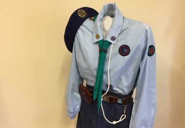
Uniform - Girl Guide Uniform, 6th Kew, Scout Association of Victoria, c.1987
This Guide uniform was worn by Jane Reid when she was a Guide at 6th St Hilary's between 1987 and 1989. The uniform consists of a pale blue blouse, junior navy A-line skirt and navy wool beret with the World Guide badge embroidered on it. The scarf with the Victorian State Badge at the back is a triangle and can be used as a sling or bandage in an emergency. Jane's woggle (a band holding the tie) was made by hand. Some girls made woggles from leather, cord or items from nature such as gumnuts. The leather belt with the Girl Guide buckle bears a metal badge obtained at Britannia Park, the Victorian Guide camping ground at Yarra Junction. Her white lanyard (indicating she was a Patrol Leader) and brown leather pouch are attached to the belt. Metal badges pinned to the collar of the blouse are the World Guide badge on the right and the Guide Trefoil or Promise badge on the left. The tapes on the left sleeve identify the Guide Company, District and Region. Badges on the right sleeve are interest and achievement badges.jane reid, costumes, uniforms, girl guides 6th kew -
 Melbourne Tram Museum
Drawing, Melbourne & Metropolitan Tramways Board (MMTB), "Plan of Tramway System - showing route mileage of electric tramways", Late 1960's
Set of 9 A3 photocopy of a drawing - of a dyeline print that had been mounted onto a cloth backing and had been kept up to date with regard to extensions and closures or opening and closing - titled - "Plan of Tramway System - showing route mileage of electric tramways" - Principal Junctions and intersections shown diagrammatically. Map of system shown at 40 chains to the inch. Copy of Drawing No. P6050. Shows crossovers, signal cabins, automatic points, closed cable tram lines in the city area, Port Melbourne, roads, railways and stations. Has extensions to Mill Park up to April 1987. Shows the Port Melbourne, North Melbourne (Spencer and Abbotsford Sts) and Collingwood cable lines, the Footscray system lines and the Point Ormond lines. See also Reg Item 1561 for a late 1960's print and 3642 for a 1941 version.trams, tramways, mmtb, trackwork, tramways, junction, map -
 Melbourne Tram Museum
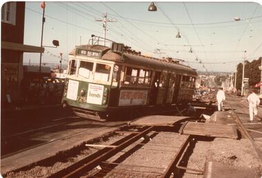
Photograph - Black and White photograph, mid to late 1970's
Set of five colour prints of tram W5 725 derailed in High St Kew during track reconstruction work at the corner of Derby St Kew. Tram was bound for North Balwyn when it derailed on a section of track that had been dismantled, possibly when it hit or dislodged a track crossover. Tram has advertisements for Bonds, Tollana Wines, Park Drive cigarettes, .1 - tram derailed at the top of the hill down to Kew Cemetery. .2 - with workmen setting up the tram and place on the temporary transport wheels. The second axle box towards the drop centre is on an angle compared to the nearest axle box. .3 - close up view of the damaged truck. .4 - General view of the scene looking back towards Kew Junction. .5 - view of the damaged crossover section. Date: during the 1970's.trams, tramways, accidents, derailments, kew, high st, north balwyn, route 48, temporary track, tram 725 -
 Melbourne Tram Museum
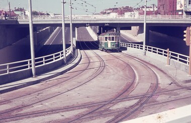
Slide - Set of 7, Keith Caldwell, 22/03/1969 12:00:00 AM
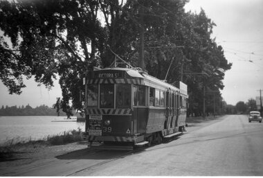
Set of seven Agfa colour slide, blue and white plastic mount, photo by Keith Caldwell on 22/3/1969 of the then new track work in Queensway St Kilda, closing the former track in Wellington St. .1 - W2 363 inbound, route 5 climbing the grade to the St Kilda Road Junction. Has the overpass in the background. .2 - W2 229 ditto .3 - W2 377 ditto waiting for another W2 5?6 crossing in front of the tram. .4 - SW6 941 outbound, route 5, Malvern Burke Road with advertisements for PGF golf clubs and Vodka Wyborowa. .5 - W2 421 outbound route 5. .6 - W2 347, East Brighton route 64 outbound in Queensway with the Windsor Fire Station and the former cable tram winding house (the big red building) in the background. .7 - A W2 inbound..1 and .6 has in pencil "22/3/1969".trams, tramways, st kilda rd, queensway, new tramway, route 5, east malvern, route 64, east brighton, w2 class, sw6 class, tram 363, tram 229, tram 377, tram 347, tram 421, tram 347, tram 941 -
 Kew Historical Society Inc
Album - Scrapbook, Eva Grant, Historic Buildings, Kew, 1958-78, 1970s
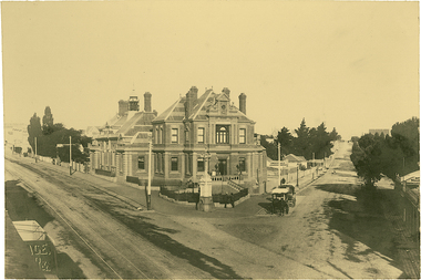
One of three scrapbooks of photographs and newspaper cuttings taken and or collected by Eva Grant, a past member of the Kew Historical Society, which were donated by her niece, Julie Thomson. The albums include many photographs of Kew from the 1950s to the 1970s. Buildings included in the scrapbook include: Billy Hughes' house - 167 Cotham Road Congregational Church - Walpole Street (c.1978) Country Roads Board - Denmark Street (1960) Dorothy Rogers Reserve - Studley Park Road Ellsmere (also Ellesmere/Ellsmore) - Princess Street Field Place - 3 Henty Court Fernhurst - 13 Fernhurst Grove Kew Civic Centre (1959) Kew Junction (1958) Kew Railway Station (1902, 1959) Kew Recreation Hall - Wellington Street (1960) Neama (Hall) - Studley Park Road Southesk (formerly Ordsall) - Cotham Road (c.1960) St Anthony's Home for Babies (formerly Madford) - 43 Wellington Street (c.1976) Studley House - Nolan AvenueThe scrapbook contains historically significant, rare and sometimes unique images of significant heritage buildings in Kew, including their erection and demolition. 11-page scrapbook of photographs and newspaper clippings with annotations by Eva Grant, a past member of the Kew Historical Society. The pages of the album can be viewed in the image carousel above. Based on the text and known dates of demolition of a number of the buildings, the scrapbook was assembled over a twenty year period between c.1958-c.1978.Includes letter from donoreva grant, billy hughes' house - 167 cotham road, congregational church - walpole street - kew, country roads board - denmark street - kew, dorothy rogers reserve - studley park road - kew, field place - 3 henty court - kew (vic), ellsmere (also ellesmere/ellsmore) - princess street - kew, fernhurst - 13 fernhurst grove - kew (vic), kew civic centre - civic drive - kew (vic), kew junction - kew (vic), kew railway station - denmark street - kew (vic), recreation hall - wellington street - kew, neama - hall - studley park road - kew (vic), southesk - ordsall - cotham road- kew (vic), st anthony's home for babies - madford - 43 wellington street (vic), studley house - nolan avenue - kew (vic) -
 Melbourne Tram Museum
Book - Cable tram records - book 2 of 4, Alf Twentyman, c1940
Second of four documents compiled by Alf Twentyman about the history of Melbourne cable trams. The first seven pages list each cable car or trailer (1 to 601) and its depot, including some notes on their individual disposal. Page 15 lists additions to the fleet of cars - 1-7-1916 to 3-6-2024 including numbers and notes. Pages 16 to 37 provide cable and track diagrams and notes on St Kilda Junction, Collins and Market St, City Road & Clarendon St, Elizabeth St, Spring-Albert and Brunswick Sts, Swanston St, (Princes Bridge to Lonsdale St) and Lonsdale St to Russell St, Spencer St and Flinders St including the Bourke St terminus, Clifton Hill terminus, Nicholson and Gertrude, Spring and Nicholson, Lygon Elgin and Rathdowne Sts, various terminal arrangements and car shed access, Queensberry and Abbotsford, St Kilda Road, Chapel and Wellington, Ackland St and other notes on the last pages.Demonstrates the recording and drawing work of Alf Twentyman and his notes.Exercise book - printed for Scotch College, ruled in an accounting ledger format - 40 pages with red card covers.On cover in ink "A E Twentyman, Inter Maths B Ledger"tramways, cable trams, alf twentyman, history, track plans, records -
 Wangaratta Historical Society
Wangaratta Historical Society
The Wangaratta Historical Society Inc. (WHS) was established in 1959 and moved into its present home in the 1970s. Wangaratta in North East Victoria has a population of over 27 thousand people and is situated at the junction of the King and the Ovens Rivers. Agriculture has always been a big part of its history as well as education, health and manufacturing. The museum was originally a fire station built 1895 and included living quarters for its staff. The building is owned by the Rural City of Wangaratta who are great supporters of the WHS The museum was bequeathed 10,000 glass negatives from the late 1800s to the 1950s these were by the Vine & Thelma studios of mostly, portraits, weddings and historical photos. Also owned by the WHS is the Maianne Gibson crazy patchwork quilt made by a Wangaratta woman in the 1890s and now Heritage listed. This Quilt is housed in an specially controlled conditions. The Wangaratta Historical Society Museum was accredited in 2012 under the Museums Accreditation Program. -
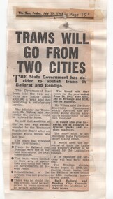 Ballarat Tramway Museum
Newspaper, Herald Sun, "Trams will go from two cities", July to Oct 1968
Yields information about the 1968 proposals to close both the Ballarat and Bendigo tramway systems by the state government.Series of newspaper clippings adhered to three quarto lined sheets about the 1968 attempt by the Victorian Government to close the Ballarat and Bendigo tramway systems. .1 - "Trams will go from two cities" - The Sun Friday 19/7/1968, about the Government's decision - gives reasons for the closure. .2 - "Protest over tram protest" - The Sun, 28/8/1968 - with a photo of No. 35 and that the Ballarat Save the Trams Committee not supporting a public protest meeting called by tramway employees. Also has cutting about the State cabinet being delayed by a good train breakdown, a Brisbane train strike and that Country considering the Underground is not vital. .3 - "The Country trams stay" - The Sun Thursday 3/10/1968 - about the Legislative Council not approving the motion to scrap the trams, Labor and Country party combined to defeat the motion. Also cutting on traffic changes to St Kilda Junction. Date of cutting has been taped onto the sheets.closure, ballarat, bendigo, parliament, st kilda junction, sec -
 Ballarat Tramway Museum
Photograph - Digital image Set of 16, Floyd Bromley, BTM Tram Showcase day, 30/9/2018, 30/09/2018 12:00:00 AM
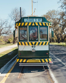
Set of 16 digital images of tram operations in Wendouree Parade during the BTM Tram Showcase day, 30/9/2018 (Oct. 2018 Fares Please!) by Floyd Bromley. .1 - No. 40 end on at St Aidans .2 - 40 and 28 ditto .3 - ditto .4 - No. 28 and crew - Peter Bruce, John Whiting and Liam Davies .5 - 26 and 27 arriving Gardens Loop .6 - 27 and 28 .7 - 28 and 40 at Carlton St .8 - 27 and 26 in Wendouree Parade .9 - 26 at Carlton St .10 - 27 descending into Depot Junction .11 - view out of 26's window .12 - 26 .13 - 26 and others at the loop, changed to Black and White .14 - 13 at St Aidans .15 - six cars at St Aidans .16 - Loop - 40, 26 and 27. Note: The white discs was a trial to indicate that a tram is following. This was an SEC practice in Bendigo. It was not subsequently adopted.trams, tramways, btm, depot, wendouree parade, carlton st, st aidans drive, gardens loop, events, tram 40, tram 28, tram 26, tram 27, tram 13 -
 Ballarat Tramway Museum
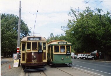
Photograph - Colour Photograph/s - set of 14, Carolyn Cleak, 12/03/2006 12:00:00 AM
Set of 14 colour photographs by Carolyn Dean during the 2006 Begonia Festival period. Printed on Kodak paper. .1 - 661 and 27 at Gardens loop - 12/3/2006 .2 - Crowd scene at Gardens Loop .3 - Neil Lardner - conductor .4 - Loading passengers - 27 Gardens Loop .5 - Group scene at Mess room - Bruce Worthington, Graeme Cleak, Neil Lardner, John Shaw, Bill Kingsley, Alastair Reither, Greg Rodgers. .6 - Graeme Cleak and Bill Kingsley, 661 at St Aidans Drive .7 - Bruce Worthington sweeping track at depot .8 - Swinging the pole at Depot Junction .9 - 40 out in the open with 26 and 8 behind - 11/3/2006 .10 - ditto .11 - 466 on 6 road .12 - 671 at Depot Jtn - 12/3/2006 .13 - Graeme Cleak issuing check tickets .14 - ditto.On rear of each photo is name and address label of Carolyn Dean and date in black ink.wendouree parade, begonia festival, btm, depot, tram 661, tram 27, tram 671, tram 40, tram 8, tram 26, tram 466