Showing 25224 items matching "north"
-
 Ballarat Tramway Museum
Photograph - Digital image Set of 10, Stuart Lodington, 1971
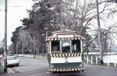
Set of 10 digital images of Ballarat trams prior to closure, scanned from original slides by Stuart Lodington, 1971 prior to closure of the system. .1 - No. 32 entering the depot from Wendouree Parade, with the Lake in the background. Shows the depot fire alarm on an adjacent pole. .2 - No. 26 at Sebastopol, before turning the pole. Has a bus stop sign on a pole already. .3 - No. 27 and 26? crossing at the Bell St loop in Skipton St. No. 27 has a Twin Lakes sign. .4 - No. 32 outbound to the Gardens in Hamilton Ave about to enter Wendouree Parade with Loreto convent and Olympic monument the background. .5 - No. 26, Albert St Sebastopol, approaching the Sebastopol terminus, with Sebastopol Food Stores building on the left of the photo. .6 - No. 12 leaving the Parker St. Loop, Sturt St West after crossing a tram. No. 12 has destination of Victoria St. .7 - No. 12 inward bound in Lydiard St North with Fine Art Gallery in the background, 3BA. No. 12 has destination of Sebastopol and has a Twin Lakes sign. .8 - No. 12 inward bound, Sturt St West, No. 12 has destination of Victoria St and has a Twin Lakes sign. .9 - No. 26 at Sebastopol terminus, outside the Royal Mail Hotel, has a bus stop sign on a pole. Tram pole yet to be turned, but destination adjusted to Lydiard St. North. .10 - No. 12 at Sebastopol terminus, outside the Royal Mail Hotel. No. 12 has destination of Lydiard St Nth and has a Twin Lakes sign.trams, tramways, ballarat, sturt st west, sebastopol, skipton st, wendouree parade, hamilton ave, depot, depot junction, parker st loop, bell st, lydiard st nth, tram 32, tram 26, tram 27, tram 12 -
 Bendigo Historical Society Inc.
Document - BENDIGO TOWN HALL ''A GOLDFIELD' PALACE'' LEAFLET, 2002
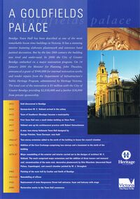
Bendigo Town Hall, Heritage Victoria ''A Goldfields Palace Blue Leaflet'' with coloured photographs and white text. Photographs courtesy of Westox Pty Ltd and the City of Greater Bendigo. 2002. Front page features the extensive work that would be undertaken for the restoration. A time line beginning 1851, gold discovered in Bendigo. 1854 German-born W. C. Vahland arrived in the colony. 1855 Town of Sandhurst (Bendigo) became a municipality. 1856 First Town Hall was a small timber building on View point. 1857 Vahland sets up his architectural practice with Robert Getzschmann. 1859 A new, two-storey Italianate Town hall designed by George Fletcher, Town Surveyor, was built. 1866-77 Two-storey extension added to the north of the building to house the council chamber. 1871-72 Addition of the Corn Exchange comprising two storeys and a basement to the north of the building. 1878-87 Major remodelling of the exterior and interior carried out to the designs of architect W. C. Vahland. The work comprised major extensions and the addition of three towers and mansard roof, reconstruction of the main stair, decorative plasterwork by Otto Waschatz (decorated Royal palace, Copenhagen), and council chamber painted by W. J. Straugher. 1902 Painting of the main hall by Coulter and Smith of Bendigo. 1913-15 Remodelling of offices. 1926 Replacement of main Hargreaves Street hall entrance, foyer and balcony with stage. 2000 Restoration works to the Town hall commence. The middle pages and the back show some of the conservation works that were required.bendigo, tourism, town hall restoration, 4-2000 www.heritage.vic.gov.au -
 Bendigo Historical Society Inc.
Document - MCCOLL, RANKIN AND STANISTREET COLLECTION: SUNDRY REPORTS, 1930's
Manilla Folder containing reports from various mines in Bendigo and surrounding areas. 1. 4 page typewritten report on the Balaclava Hill Mine at Rushworth and some newspaper clippings about the mine with a plan of the underground workings; 2. Page from the Árgus' dated 2nd August 1900 featuring an article on the survey of the Garden line of Reefs; 3. 5 page report with maps on the Tooleen Gold Field; 4. Single page report about an unnamed mining area claimed to be on the southern end of the Deborah line of reef. (this could be the 'Three Jays' mine in Sedgwick. P. Wilkin); 5. Hand written report on the Coronation Mine, 2 miles east of Walhalla.; 6. Hand written report dated 1935, of the Queen Mary mine, St. Arnaud.; 7. 1932 report on the North Neangar lease.; 8 4 page report on the Kings Prize Gold Mining Syndicate.; 9. Description of the plant of the Marong Alluvial Company? Also a guide for marking out leases.; 10. Crushing details (1 page) from the 'Enterprise' Mine South of and adjacent to Perseverence.; 11. 1 page crushing details from Rowe Brothers, Mosquito Mine, Fryerstown.; 12 hand written report mentions Arthur Hatfield, Scarsdale.; 13. Map with lines of reef showing the position of the New Moon Consolidated and the New Moon United shafts.; 14, Large scale map from Harrison/Victoria street to Havilah Road showing the positions of the Carlisle, North Garden and Unity Shafts.gold mining, miners' safety cage, sundry reports, mining. bendigo, rushworth, balaclava hill, garden line of reef, toolleen, coronation mine, walhalla, queen mary mine, st. arnaud. north neangar, kings prize gold mining syndicate, marong, enterprise mine, perseverence, rowe brothers, mosquito mine, fryerstown, arthur hatfield, scarsdale, new moon consolidate, new moon united, carlisle, north garden, unity. -
 Ballarat Tramway Museum
Photograph - Copy photograph, Murray Views, Murray Views Photo No. 29, 1948
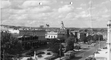
Yields information about Sturt St Ballarat during the late 1940's and the appearance of the trams at the time of the photograph.Photo of Sturt St. looking North East from Town Hall with tram 32 westbound. Tunbridge store (now demolished in photo), Murray Views Photo No. 29, noted on rear with handwritten note on rear. Has two punch holes on top margin. Assumed from notes, taken between late 1947 and 1948. Notes on Photograph of tram 32 passing Town Hall, in Sturt St., westbound Tramcar - has one colour side panels, which were applied to the trams between 1946 and 5/1950. (Car history cards may define the date 32 was painted - see record 5543/ ) Between 1935 and 1946, trams were painted with cream rocker panels and green under the windows as tram 27 is currently painted. From discussions with Kevin Monkhouse (MFBB) on 27.11.95, the car crossing Armstrong St from North to South is a Ford Roadster, of the 1935 era. Other cars in the street are also pre-war cars. No Holdens' are easily apparent. From this, the date of the photograph taken is assumed to be post 1946, but before 1948. Reg Item 5543, gives the date of painting of the tram to all green as September 1947. Warren Doubleday 27.11.95 and updated on 14/9/2013. See also Reg Item 5313 for a narrower view of this photo. Wal Jack in item 5313 has dated it as 1948 - note added 23/3/2012. see attached notes. On rear in ink "29 - Sturt St. Looking East from Doveton St. (WJ)"trams, tramways, ballarat, sturt st., trams, town hall , tram 32 -
 Melbourne Tram Museum
Ephemera - Tram Route Guides, Public Transport Victoria (PTV), "Tram Route Map", 1/2015 and 6/2015
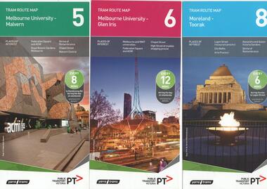
Set of 7 Tram Route Maps, published during 2015. Each comprises a vertical DL folded sheet, full colour for the nominated routes, with Yarra Trams and PTV logos, listing the stops, interchanges with bus and other tram services, ticketing zones, estimated frequencies with adverts for Night tram services, TramTracker and Myki tickets. .1 - Route 5 - Melbourne University to Malvern .2 - Route 6 - Melbourne University to Glen Iris .3 - Route 8 - Moreland to Toorak .4 - Route 11 - West Preston - Victoria Harbour Docklands .5 - Route 19 - North Coburg - Flinders St Station .6 - Route 70 - Wattle Park to Waterfront City Docklands .7 - Route 72 - Melbourne University to Camberwell .8 - Route 1 - East Coburg - South Melbourne Beach .9 - Route 3 and 3A - Melbourne University to East Malvern .10 - Route 16 - Melbourne University to Kew .11 - Route 55 - West Coburg - Domain Interchange .12 - Route 57 - West Maribyrnong - Flinders St Station .13 - Route 59 - Airport West - Flinders St. Station .14 - Route 64 - Melbourne University - East Brighton .15 - Route 67 - Melbourne University - Carnegie .16 - Route 78 - North Richmond - Balaclava via Prahran .17 - Route 82 - Footscray - Moonee Ponds See Reg Item 2396 for 2012, 2278 for 2016 and 2940 for 2014 versionstrams, tramways, timetables, maps, route 1, route 3, route 5, route 6, route 8, route 11, route 16, route 19, route 55, route 57, route 59, route 64, route 67, route 70, route 72, route 78, route 82, east coburg, south melbourne, east malvern, kew, west coburg, west maribyrnong, airport west, east brighton, carnegie, north richmond, balaclava, footscray, moonee ponds, malvern, glen iris, moreland, west preston, north coburg, wattle park, camberwell -
 Melbourne Tram Museum
Ephemera - Tram Route Guides, Public Transport Victoria (PTV), "Tram Route Guide and Map", Oct. 13 to July 14
Set of 17 Tram Route Maps, published during 2013 and 2014. Each comprises a vertical DL folded sheet, full colour for the nominated routes, with Yarra Trams and PTV logos, listing the stops, interchanges with bus and other tram services, ticketing zones, estimated frequencies with adverts for Night tram services, TramTracker and Myki tickets. .1 - Route 3 - East Malvern - Melbourne Uni and 3A via St Kilda (Sat and Sun) .2 - Route 6 - Melbourne University to Glen Iris .3 - Route 12 - St Kilda - Victoria Gardens .4 - Route 16 - Kew via St Kilda .5 -Route 30 - St Vincent's Plaza - Etihad Stadium .6 - Route 55 - West Coburg - Domain Interchange .7 - Route 59 - Airport West - City (Elizabeth St) .8 - Route 64 - Melbourne University - East Brighton .9 - Route 70 - Wattle Park to Waterfront City Docklands .10 - Route 75 - Docklands - Vermont South .11 - Route 78 - North Richmond - Balaclava .12 - Route 82 - Moonee Ponds - Footscray .13 - Route 86 - Bundoora - Waterfront City .14 - Route 96 - East Brunswick - St Kilda Beach .15 - Route 109 - Box Hill - Port Melbourne .16 - Route 112 and 11 - West Preston - St Kilda and West Preston - Victoria Harbour Docklands .17 - Route 24 - North Balwyn to Etihad Stadium See Reg Item 2396 for 2012, 2278 for 2016 and 2939 for 2015 versionstrams, tramways, timetables, maps, route 3, route 6, route 11, route 12, route 16, route 24, route 30, route 55, route 59, route 64, route 70, route 75, route 78, route 82, route 86, route 96, route 109, route 112, east malvern, glen iris, victoria gardens, kew, st vincent's plaza, west coburg, airport west, east brighton, wattle park, vermont south, north richmond, moonee ponds, footscray, st kilda, docklands, west preston, victoria harbour, north balwyn, etihad stadium -
 Melbourne Tram Museum
Ephemera - Timetable, Melbourne & Metropolitan Tramways Board (MMTB), "Running Timetable and Locations of Recording Clocks", Jun. 1973
Set of photocopies of timetable information titled "Running Timetable and Locations of Recording Clocks" for various tram and bus routes - dated June 1973, signed R. C. Drummond Traffic Manager. Gives running times for sections during various parts of the day, early am, am peak, mid period, pm peak, weekdays, Saturdays and Sundays, and evening and the location of Bundy Clocks. Photocopied or retyped by donor 2016. 1442.1 - two sheets copied onto A4 paper and scanned to a pdf file. East Brighton - City via Swanston Carnegie - City East Malvern - City East Brighton - City - Dudley St Glen Iris -City Malvern Burke Road - City Camberwell - City via William St Camberwell - City via Swanston St Burwood - Spencer St Toorak - City Weekdays North Balwyn - City Wattle Park - Princes Bridge East Preston - City West Preston - St Kilda Beach Essendon Aerodrome - City West Maribyrnong Moreland - St Kilda Beach West Coburg - Domain Road North Coburg - City East Coburg - South Melbourne Beach. On A5 sheets - one large scan Carnegie - City - June 1973 Bulleen to Garden City - 18 June 1972 Bulleen to Garden City - Nov. 1963 East Brighton - City - Dudley St - Nov. 1968 East Brighton - City - via Swanston St - June 1973.trams, tramways, timetables, schedules, bundy clock, mmtb -
 Melbourne Tram Museum
Photograph - Set of 15 Black & White Photograph/s, Melbourne & Metropolitan Tramways Board (MMTB), 1950's
Series of 15 black and white photographs of the track works to reconstruct tram lines showing various methods and works during the 1960's. .1 - Jackhammers concrete out around wooden sleepers - the rails have been bolted to them. .2 - Excavated track or temporary track next to newly relaid track - Hawthorn Road by Caulfield Park? .3 - Partly completed work - nearest track relaid, second track still has wood blocks? and then a temporary track. .4 - Excavated previously concreted and bolted track. Appears to be new rail. .5 - Compacting a new track bed with work laying track in the background. .6 - Rail being craned into position onto small concrete blocks - Nicholson St North Fitzroy at Church St - the church is now Melbourne City Mission Palliative care centre. 1955/56 - construction of the replacement track. Note the Hail bus stop sign on the corner. .7 - Thermite welding being set up. .8 - after a Thermite welding joint completed. .9 - track reading for pouting concrete, with a rebuilt track alongside and temporary track on the other side. .10 - ditto .11 - Concrete being poured .12 - ditto - could be Maribyrnong Road bridge replacement. .13 - Screeding off the concrete - possibly Nicholson St North Fitzroy .14 - completed surface - location as above .15 - completed surface with cloth covers to assist the concrete being cured. Has a MMTB hut and two worker amenity buses alongside. - location as above.Some photos have pencil marks on rear.trams, tramways, trackwork, rails, track materials, track repairs, sleepers, equipment, concrete, welding, nicholson st, new tramway, buses -
 Bendigo Historical Society Inc.
Document - VICTORIA HILL - KEY TO SIGN POSTS ON AREA MAP
Three page hand written carbon copy of Sign numbers at Victoria Hill. No 1 North Old Chum Shaft, No 2 Ballerstedt's First Open - Cut. Special Sign Post, No 2 C Rock Formations Pitching North, No 2 B Rich shallow shafts, No 2 A Quartz veins, No 4 A Concrete Dams, No 3 Engine Beds - Lansell's 'Big 180' Mine, No 3 B Lansell's 'Big 180' Shaft, No 4 Twenty Stampers Crushing Battery, No 3 C Foundations - 'Cleopatra Needle' type Chimney for Lansell's 'big 180' Mine, No 5 Victoria Quartz Mine, No 5 A Fou;ndations Victoria Quartz Poppet Legs, No 5 C Foundations Victoria Quartz Winding Plant, No 5 B Victoria Quartz Dams, No 6 Rae's Open - Cut, No 9 Quartz Once Roasted Here, No 12 Anticlinal Arch, No 15 primitive Tunnels, No 14 Beautifully Coloured Rock Formations, No 16 Adit, Graded Bedding, Oblique Fault, Spurry Quartz Veins, No 17 Prospecting Tunnels, No 18 Floyd's Small Crushing Battery, No 19 Gt Central Victoria (Midway) Shaft, No 20 Great Central Victoria (Midway) Engine Bed, No 21 ballerstedt's Small 24 Yard Claim, No 22 Humboldt Shaft, No 23 Wittscheibe's 'Jeweller's Shop', No 24 The 'Adventure' ground, Large Open - Cut, No 26 Luffsman and Sterry's Ground, NO 27 A Round Shaft, Notes prepared by Albert Richardson.mine, gold, victoria hill, victoria hill, victoria hill key to sign posts on area map, north old chum shaft, ballerstedt's first open cut, lansell's big 180 shaft, 'cleopatra needle' type chimney, victoria quartz mine, rae's open cut, prospecting tunnels, floyd's small crushing battery, gt central victoria (midway) shaft, ballerstedt's small 245 yard claim, humboldt shaft, wittscheibe's 'jeweller's shop', adventure, luffsman and sterry's ground, david sterry, sterry's 'gold mines' hotel, round shaft -
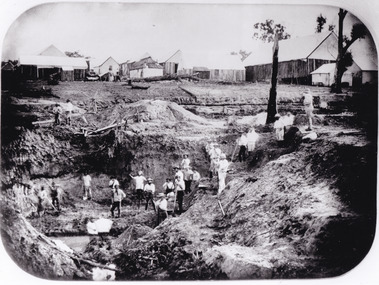 The Beechworth Burke Museum
Photograph - Photograph - Reproduction
After gold was discovered to be deposited "for miles along Woolshed Valley" in the early 1850s, the Woolshed became a major site of mining activity in the north-east . This region was divided into large claims of 80 yards long, one of which was the one depicted in this photograph, called 'Big Johnson's Claim'. Claims such as this utilised a range of technology, including water wheels, steam engines, sluices and toms, most of which would not arrive until after 1856 when this photograph was taken. The Woolshed initially became prosperous in 1855, and labourers, such as the ones depicted in this photograph, engaged in sinking work for 7 pounds a week, whilst other mining labourers could earn up to nine. The search for gold is ingrained into the history of Victoria and therefore, images like this one which portray an open cut sluicing site can reveal important information for society and technology for the date when the photograph was taken. This image is of important historical significance for its ability to convey information about the operations of mining claims, particularly of the Woolshed Valley area that this photograph documents. This image is important for current research into the history of Woolshed, which was a major site of mining significance and operations. Therefore, this image has the capacity to be beneficial for research into society and the motivations of those living and working in this region during this period and therefore, has social significance. The Beechworth Burke Museum has additional images relating to gold sluicing and the Woolshed area which can be analysed and studied alongside images like this one. A black and white rectangular photograph printed on matte photographic paper.Reverse: 7791 / page 34. / 52% / Big Johnstone / Claim on Woolshed Goldfields / 1856 / Note canvas [illegible] building / Burke Museum /woolshed, mining, claims, mining claims, big johnson, gold -
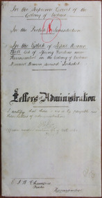 Warrnambool and District Historical Society Inc.
Document - Jessie M Wall Letters of Administration 1898, 1898
Tait collection: item 45 of 62 This is a document giving details of the Letters of Administration following the death of Jessie Wall (nee Wood) who died intestate in Warrnambool in 1897 at the age of 53. She lived in the area in north Warrnambool known as Spring Gardens and left real estate to the value of £400 and personal estate to the value of £484. The estate was granted to her husband, Joseph Wall. The lawyer concerned with this document, Ernest Chambers, had legal offices in Port Fairy, Koroit and Warrnambool at the end of the 19th century and the beginning of the 20th century. He was in possession of this document and it was passed down to successive lawyers occupying legal premises in Kepler Street. It was located in this building in 2014.This document is of some significance as it contains details of the Letters of Administration of Jessie Wall who was a 19th century resident of Warrnambool. Her husband’s father was an important early settler in Warrnambool. The document will be useful to researchers.This is a cream-coloured piece of parchment paper folded in two with handwritten material on two pages (brownish-black ink). One of the pages has hand-ruled black lines on the edges of the page. A seal of the Supreme Court of Victoria is attached with green ribbon and there is also a red stamp of the Master in Equity of the Supreme Court. The document is a little stained but the writing is legible. The document gives details of the Letters of Administration following the death of Jessie Wall of Warrnambool who died in November 1897.In the Supreme Court of the Colony of Victoria In the Probate Jurisdiction In the Will of Jessie Maria Wall late of Spring Gardens near Warrnambool in the Colony of Victoria Married Woman deceased Intestatejessie wall, ernest chambers, warrnambool, tait collection, spring gardens -
 Eltham District Historical Society Inc
Photograph - Aerial Photograph, Landata, Eltham, Vic, Jan. 1951
Centred on Allison Crecent Reserve, Sherbrook Road and Scenic Crescent, Eltham bounded by Allendale Road to north, Dudley Street to south, Zig Zag Road to east and St Helena Road to west. Historic Aerial Imagery Source: Landata.vic.gov.au Aerial Photo Details: Project No :65 Project : MELBOURNE AND METROPOLITAN PROJECT NO. 2 Run : 7 Frame : 10 Date : 01/1951 Film Type : B/W Camera : EAG9 Flying Height : 12200 Scale : 12000 Film Number : 1419 GDA2020 : 37°42'14"S, 145°08'36"E MGA2020 : 336339, 5825416 (55) Melways : 21 H2 (ed. 42)Historical aerial photos and photo maps provide viusal evidence of the chronology of changes to the built landscape of the district and assist in dating other imagesaerial photo, 1951-01, eltham, neil webster collection, allendale road, allison crecent reserve, dudley street, melway 21h2, scenic crescent, sherbrook road, st helena road, zig zag road -
 Eltham District Historical Society Inc
Photograph - Aerial Photograph, Landata, Montmorency, Feb. 1956
Centred on present day Grand Boulevard and Olympic Way, Montmorency bounded by Diamond Street to north, Old Eltham Road and Eltham Lower Park to south, Bible Street to east and Para Road to west. Historic Aerial Imagery Source: Landata.vic.gov.au Aerial Photo Details: Project No :250 Project : MELBOURNE OUTER SUBURBS PROJECT Run : 17 Frame : 115 Date : 02/1956 Film Type : B/W Camera : EAG9 Flying Height : 10000 Scale : 12000 Film Number : 1176 GDA2020 : 37°43'24"S, 145°07'55"E MGA2020 : 335375, 5823236 (55) Melways : 21 F7 (ed. 42)aerial photo, 1956-02, neil webster collection, eltham, main road, montmorency, bible street, diamond street, eltham lower park, grand boulevard, melway 21f7, old eltham road, olympic way, para road -
 Eltham District Historical Society Inc
Photograph - Aerial Photograph, Landata, Eltham, Feb. 1956
Centred on present day Mount Plaeasant Road near Dalton Street, Eltham bounded by Luck Street to north, Eltham Lower Park to south, Reynolds Road to east and Central Park to west Historic Aerial Imagery Source: Landata.vic.gov.au Aerial Photo Details: Project No :250 Project : MELBOURNE OUTER SUBURBS PROJECT Run : 18 Frame : 93 Date : 02/1956 Film Type : B/W Camera : EAG9 Flying Height : 10000 Scale : 12000 Film Number : 1176 GDA2020 : 37°43'02"S, 145°09'38"E MGA2020 : 337871, 5823961 (55) Melways : 22 B6 (ed. 42)aerial photo, 1956-02, neil webster collection, eltham, central park, eltham lower park, luck street, melway 22b6, nyora road, reynolds road, dalton street, mount pleasant road -
 Eltham District Historical Society Inc
Photograph - Aerial Photograph, Landata, Eltham, Vic, Feb. 1956
Centred on present day Parsons Avenue at Leane Drive near the Maroondah Aqueduct, Eltham bounded by Lorimer Road to north, Thompson Crescent and Norman Road to south, Bells Hill Road to east and Parsons Road to west Historic Aerial Imagery Source: Landata.vic.gov.au Aerial Photo Details: Project No :250 Project : MELBOURNE OUTER SUBURBS PROJECT Run : 19 Frame : 5 Date : 02/1956 Film Type : B/W Camera : EAG9 Flying Height : 10000 Scale : 12000 Film Number : 1176 GDA2020 : 37°42'04"S, 145°11'09"E MGA2020 : 340064, 5825786 (55) Melways : 22 H1 (ed. 42)aerial photo, 1956-02, neil webster collection, allendale road, bells hill road, eltham, leane drive, lorimer road, maroondah aqueduct, melway 22h1, norman road, parsons road, research (vic.), thompson crescent -
 Eltham District Historical Society Inc
Photograph - Aerial Photograph, Landata, Eltham, Vic, Apr. 1963
Centred on present day Zig Zag Road and Main Road, Eltham bounded by Maroondah Aqueduct to north, Thompson Crescent and Arthur Street to south, Parsons Road to east and Glen Park Road and Banks Road to west. Historic Aerial Imagery Source: Landata.vic.gov.au Aerial Photo Details: Project No :486 Project : MELBOURNE (1963) PROJECT Run : 5 Frame : 59 Date : 04/1963 Film Type : B/W Camera : RC8 Flying Height : 5100 Scale : 9600 Film Number : 1805 GDA2020 : 37°42'24"S, 145°08'52"E MGA2020 : 336716, 5825114 (55) Melways : 21 J3 (ed. 42)aerial photo, neil webster collection, eltham, 1963-04, arthur street, banks road, glen park road, maroondah aqueduct, melway 21j3, parsons road -
 Eltham District Historical Society Inc
Photograph - Aerial Photograph, Landata, Eltham, Vic, Apr. 1963
Centred on present day Floriston Grove, Eltham bounded by Maroondah Aqueduct to north, Thompson Crescent and Diosma Road to south, Research Shops to east and Glen Park Road and Park West Road to west. Historic Aerial Imagery Source: Landata.vic.gov.au Aerial Photo Details: Project No :486 Project : MELBOURNE (1963) PROJECT Run : 5 Frame : 60 Date : 04/1963 Film Type : B/W Camera : RC8 Flying Height : 5100 Scale : 9600 Film Number : 1805 GDA2020 : 37°42'24"S, 145°09'29"E MGA2020 : 337622, 5825128 (55) Melways : 22 B3 (ed. 42)aerial photo, neil webster collection, eltham, 1963-04, diosma road, floriston grove, maroondah aqueduct, melway 22b3, park west road, research (vic.), research shops -
 Eltham District Historical Society Inc
Photograph - Aerial Photograph, Landata, Lower Plenty, Vic, Apr. 1963
Centred on present day Old Eltham Road near Araluen Centre, Lower Plenty bounded by Cromwell Street to north, Yarra River to south, Main Road at Mount Pleasant Road to east and Panorama Avenue to west. Historic Aerial Imagery Source: Landata.vic.gov.au Aerial Photo Details: Project No :486 Project : MELBOURNE (1963) PROJECT Run : 7 Frame : 231 Date : 04/1963 Film Type : B/W Camera : RC8 Flying Height : 5100 Scale : 9600 Film Number : 1805 GDA2020 : 37°44'03"S, 145°07'56"E MGA2020 : 335420, 5822027 (55) Melways : 21 F10 (ed. 42)aerial photo, neil webster collection, 1963-04, araluen, cromwell street, eltham, lower plenty, main road, melway 21f10, mount pleasant road, old eltham road, panorama avenue, yarra river -
 Eltham District Historical Society Inc
Photograph - Aerial Photograph, Landata, Eltham, Vic, Apr. 1963
Centred on present day Eltham Lower Park bounded by Brougham Street to north, Yarra River and Fitzsimons Lane Bridge to south, Main Road at Kent Hughes Road to east and Bolton Street to west. Historic Aerial Imagery Source: Landata.vic.gov.au Aerial Photo Details: Project No :486 Project : MELBOURNE (1963) PROJECT Run : 7 Frame : 232 Date : 04/1963 Film Type : B/W Camera : RC8 Flying Height : 5100 Scale : 9600 Film Number : 1805 GDA2020 : 37°44'03"S, 145°08'33"E MGA2020 : 336329, 5822040 (55) Melways : 21 H10 (ed. 42)aerial photo, neil webster collection, 1963-04, bolton steet, brougham steet, eltham, eltham lower park, fitzsimons lane bridge, kent hughes road, melway 21h10, yarra river -
 Eltham District Historical Society Inc
Photograph - Aerial Photograph, Landata, Research, Vic, Apr. 1972
Centred on present day Main Road, Research near Maroondah Aqueduct and Eltham College bounded by Allendale Road to north, Research-Warrandyte Road to south, Swipers Gully Training Restaurant to east and Reynolds Road to west. Historic Aerial Imagery Source: Landata.vic.gov.au Aerial Photo Details: Project No :985 Project : MELBOURNE 1972 Run : 26 Frame : 194 Date : 04/1972 Film Type : B/W Camera : RC10 Flying Height : 5700 Scale : 9600 Film Number : 2636 GDA2020 : 37°42'07"S, 145°11'07"E MGA2020 : 340015, 5825692 (55) Melways : 22 H1 (ed. 42)aerial photo, neil webster collection, 1972-04, allendale road, eltham college, main road, maroondah aqueduct, melway 22h1, research (vic.), research-warrandyte road, reynolds road, swiper's gully -
 Eltham District Historical Society Inc
Photograph - Aerial Photograph, Landata, Eltham, Vic, Apr. 1972
Centred on present day Diamond Creek Trail at the Eltham Leisure Centre bounded by Central Park to north, Main Road at Falkiner Street to south, MacMahon Ball Paddock to east and Grand Boulevard at Buena Vista Drive to west. Historic Aerial Imagery Source: Landata.vic.gov.au Aerial Photo Details: Project No :985 Project : MELBOURNE 1972 Run : 28 Frame : 207 Date : 04/1972 Film Type : B/W Camera : RC10 Flying Height : 5700 Scale : 9600 Film Number : 2635 GDA2020 : 37°43'25"S, 145°08'20"E MGA2020 : 335985, 5823223 (55) Melways : 21 G7 (ed. 42)aerial photo, neil webster collection, 1972-04, eltham, buena vista drive, central park, diamond creek trail, eltham leisure centre, falkiner street, grand boulevard, macmahon ball paddock, main road, melway 21g7 -
 Eltham District Historical Society Inc
Photograph - Aerial Photograph, Landata, Eltham, Main Road; Mt Pleasant Rd to Railway Rd, Dec. 1945
Centred on Main Rd and Henry St, Eltham bounded by Railway Road to north, Mount Pleasant Road at Main Road to south, top of the hill in Arthur Street to east and Karingal Drive at Sherbourne Road to west. Historic Aerial Imagery Source: Landata.vic.gov.au Aerial Photo Details: Project No :65 Project : MELBOURNE AND METROPOLITAN PROJECT NO. 2 Run : 8 Frame : 70 Date : 01/1951 Film Type : B/W Camera : EAG9 Flying Height : 12200 Scale : 12000 Film Number : 1419 GDA2020 : 37°43'06"S, 145°08'45"E MGA2020 : 336589, 5823811 (55) Melways : 21 J6 (ed. 42)aerial photo, eltham, main road, henry street, arthur street, bolton street, eltham-yarra glen road, neil webster collection, 1951-01, dave lyon house, ernie andrew house, karingal road, melway 21j6, mount pleasant road, railway road -
![Photograph - Digital image, Willis Vale [side view], 1950c](/media/collectors/4f729f5697f83e03086015b8/items/5502a2592162f11024c32328/item-media/5502a2852162f11024c3268d/item-fit-380x285.jpg) Greensborough Historical Society
Greensborough Historical SocietyPhotograph - Digital image, Willis Vale [side view], 1950c
Willis Vale: House built by Edward Maygar, Robert Whatmough lived there mid 19th century and later sold to Partington family. It was located on the Plenty River at Partington's Flat Greensborough. Land use included farming and orchards. The derelict Willis Vale house was vandalized in 1964 and destroyed when a fire originating from North Plenty Gorge - Kurrak Road - was lit by two teenage boys and made its way several kilometres down to Partington's Flat Greensborough. This photo was taken after the Partington's moved house in 1947. across the river where Alan built their new Alwyn house that had access to electricity. Home of the Partington family Home of the Partington familyDigital copy of black and white photograph.willis vale, partington, whatmough, maygar -
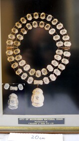 City of Moorabbin Historical Society (Operating the Box Cottage Museum)
Photograph - Photograph , City of Moorabbin Mayoral Chain, circa 1990
City of Moorabbin was proclaimed 1934 and managed the areas of Cheltenham, Highett, Moorabbin, Bentleigh, East Bentleigh, East Brighton, McKinnon, Ormond until the Amalgamation of Councils in 1994. The City of Kingston then took over the area south of South Road while City of Glen Eira took the area to the north Kingston City Council possesses the original Mayoral Chain of former City of Moorabbin and it is displayed on the Moorabbin Mayoral Robe at KCC Office Cheltenham for the Annual Opening meeting of KCC in February . 2018 The Moorabbin Mayoral Robe was sent on 7 year loan to KCC for display at Cheltenham with the former City of Chelsea and former City of Mordialloc Mayoral Robes.Since the 1960s far-sighted community members have generously donated many significant items to the ‘Box Cottage’ museum, specifically to provide future generations with a fascinating, and tangible insight into day-to-day life from the 1800’s and up to the mid 1900's. Moorabbin City Council supported their efforts until the Amalgamation of Councils 1994. The City of Kingston donated the 1990 City of Moorabbin Mayoral Robes in 2007 Photograph of the City of Moorabbin Mayoral Chain circa 1990 in a glass covered, wooden frame Photograph of Mayoral Chain worn by Kingston City Council Mayor Steve Staikos, with Councillor Brownlees, in November 2018 when Robe and Jabot were loaned to KCC by CMHS Box Cottage MuseumPlate at base of photograph frame states ' City of Moorabbin Mayoral Chain /Manufactured By / P. Blashki & Sons Pty.Ltd'/moorabbin, kingston, mayors, glen eira, mayoral chain, moorabbin shire -
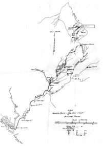 Tatura Irrigation & Wartime Camps Museum
Map - Map - Photocopy, New Guinea Escape Route
At the end of January 1942 there was only about 250 men left in Wau, as the women and children had been evacuated by air a little earlier. With no planes to take the men they had to make their own way to Port Moresby and then travel by ship to Australia. Some men went down to Salamaua and made their way along the north coast, but small groups also made their way over the Owen Stanley Ranges; rafting down the Lakekamu RIver to Yule Island and by boat to Port Moresby. Donor Vanessa Kiessling's Father was part of the second group, and had drawn a detailed map of their route. This might be the same route taken by Rev. Willi Hertle (Ref C0750)Photocopy of New Guinea map showing escape routePlan of surveyed route from Edie Creek to Bulldog Dromepapua new guinea, escape, map, wau, willi hertle, kiessling -
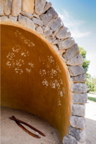 City of Ballarat
Artwork, other - Public Artwork, Deanne Gilson, Murrup Laarr by Deanne Gilson, 2019
Murrup Laarr translates as 'Ancestral Stones' in Wadawurrung. This artwork by Dr Deanne Gilson is located in the North Gardens Indigenous Sculpture Park. The park is a significant project for the City of Ballarat and features works by Aboriginal and Torres Strait Islander artists, celebrating the richness and diversity of culture and telling important cultural stories. Dr Deanne Gilson is a Wadawarrung Traditional Custodian and established artist. She installed the first artwork commissioned by the City of Ballarat for the Sculpture Park in early 2019. Murrup Laarr is a contemporary artwork consisting of a traditionally-built stone hut in the middle of a circle of basalt standing stones, marked with ceramic plates reflecting the stories and symbols of dreaming, memory, ceremony.The artwork is of aesthetic and cultural, social and spiritual significance to the people of Ballarat and to Wadawurrung peopleA traditional hut made from river stone and stacked rocks, with the hut surrounded by large basalt rocks with plaques featuring unique designs on stoneware plates imbedded into them. Murrup Laarr (Ancestral Stones), 2019 / By Deanne Gilson / Wadawurrung people have always used stones to mark places of ceremony and important business. The stones are the holders of memory and knowledge, Country and Spirit. They mark the cosmos and seasons. They follow the sun, marking the summer and winter solstice, important dates for planting and harvesting and telling stories of past, present and future. / The stones are alive and still present. Murrup Laar has been created using local basalt stones to tell Wadawurrung stories of dreaming, memory and ceremony. / “Creating Murrup Laarr (Ancestral Stones) at this time has placed Aboriginal people and practices back on Country and created a place to tell our stories. I am very honoured to have had this opportunity. An Aboriginal stone circle existed in Ballarat pre-colonisation; by putting back what was lost throughout colonisation I pay homage to my ancestors, past, present and emerging”/ – Deanne Gilson, March 2019 murrup laarr, wadawurrung -
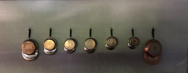 Robin Boyd Foundation
Functional object - Cookware, Revere Ware
Robin Boyd developed a close friendship with the founder of the Bauhaus in Weimar Germany, Walter Gropius, who had moved to the USA in the 1930s. Through this connection, Boyd was invited to be the Massachusetts Institute of Technology (MIT) Bemis Professor at the School in the North American academic year 1956-7. During this time, the Boyds purchased this set of Revere kitchenware, which carries the prized "Process Patent" maker's mark on the thick copper bases. Mandie Boyd recalls: "I don’t remember a lot of cooking going on in them, if any, as they were a pain to clean but looked fabulous hanging on the wall absolutely gleaming. We would all check our hair and make up in them."A set of Revere Ware Saucepans and Frying Pans. A set of four Revere Ware copper clad, stainless steel saucepans with lids and black handles and hanging rings. A set of three Revere Ware copper clad, stainless steel pans with black handles and hanging rings. The largest flat one has no lid. Saucepans: largest 175mmx140mm, smallest 120mmx180mm. Frying Pans: largest 350mmx10mm, smallest 80mmx50mm.Revere Ware company engraving. Made under process patent #2363973. 'Revere Ware 1801' 'Patent # 22726091'revere, revereware, revere ware, cookware, walsh st kitchenware, robin boyd, ohm2022, ohm2022_10 -
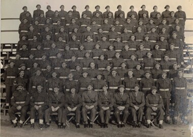 8th/13th Victorian Mounted Rifles Regimental Collection
Photograph - 2/8th AR
The 2/8th Armoured Regiment was raised in June 1941 under the command of Lieutenant Colonel W G Hopkins with officers and men selected from the wider AIF in Victoria. The regiment trained in newly arrived M3 General Grant tanks at Puckapunyal before moving north to Singleton, then the Wee Waa plains. The regiment sailed for New Guinea in April 1943 and carried out mobile defence to airfields at Port Moresby, Milne Bay, Dobadura and Popondetta. The regiment returned to Australia in February 1944 and disbanded as an armoured regiment and retrained as Nos 41, 42 and 43 Landing Craft Companies. They returned to the South West Pacific serving at Bougainville, Balikpapan, Lae and Wewak.Black and white photograph of squadron of armoured regiment soldiers, thought to be 2/8th Armoured Regiment. c. 1942armour, uniform, world war two, wwii, ww2 -
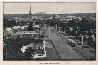 Ballarat Tramway Museum
Photograph - Illustration, "Sturt Street Ballarat to-day", c1905/6
Set of two views from an illustrated publication on Ballarat. 1 - Illustration - "Sturt Street Ballarat to-day" looking east from the City Fire station along Sturt St with an ESCo tram eastbound. The destination sign is mounted on the dash panel indicating c1905/1906. In the view are Ballarat's Buildings, Mount Warrenheip, J Taylor Redhouse Bakery, and on the bottom edge a sign for Marshall's. 2 - Illustration - Post Office Ballarat, to-day - with an ESCo tram turning from Sturt St into Lydiard St North, with the Post Office in the view along with many pedestrians and some horse drawn vehicles. See also item 6245 for a postcard of the same view.Yields information about Ballarat and city views in 1905/1906.Illustration cut from a magazine or publication - set of two - back to backThe second image has "1912" in pencil along the bottom edge.ballarat, illustrations, sturt st, esco, post office, lydiard st nth -
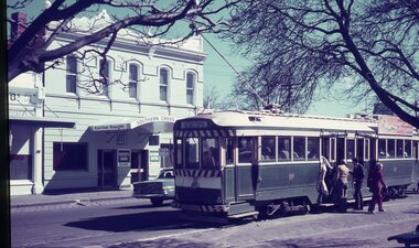 Ballarat Tramway Museum
Slide - 35mm slide/s - set of 3, Dave Simpson, trams in Sturt St near Hospital Corner, late 1960's early 1970's
.1 -No. 35, outbound to Sebastopol with the Southern Cross Hotel in the background. Has signs for Fosters Larger, Carlton Draught and Victoria Bitter. Has a number of passengers boarding the tram. .2 - at Hospital corner with the signal system control box for the Forest City signals in the foreground on a pole. Has marking for Sebastopol, Sturt St West and Drummond St North? written on the box. Above this is a sign advising passengers that trams depart this point for The Gardens, View Point and Sebastopol. In the background is J. A. Malpass Hairdresser shop. See item 8900 for the actual switch. .3 - No. 35 turning into Drummond St south with the bottle shop on the south east corner in the background.Yields information about Hospital corner and the switch for the Forest City signalling system controls.Set of three 35mm slides - AGFA dark blue / white plastic mounts of trams in Sturt St near Hospital Corner. tramways, trams, sturt st, hotels, hospital corner, forest city signals, signs, tram 35