Showing 3207 items
matching road map
-
 Glen Eira Historical Society
Map - CAPLES PLACE SUBDIVISION
... Planning Garden Road Map CAPLES PLACE SUBDIVISION ...This file contains a copy of a map of the CAPLES PLACE SUBDIVISION, undated and author unknown. The map provides the dimensions of roads and allotments in the area, including also handwritten notes from the original document and others written directly onto the copy.land subdivisions, documents, maps, glen eira, caples place, caples place subdivision, land surveys, orrong road, mulgrave road, prahran grove, somerset road, prahran grove, prahran grove, east walk, land allotments, town planning, garden road -
Glen Eira Historical Society
Document - Alcoholics
This file contains one page of handwritten notes on the Caulfield Institute for Alcoholics, undated and author unknown. The notes include the address of the Sanatorium and a small map of the location, as well as details of references to the sanatorium in various directories.social problems, alcohol and drugs, caulfield, hospitals, caulfield hall, caulfield institute for alcoholics, directories, orang road, alma road, st. aubins avenue, hotham street, east st. kilda -
Glen Eira Historical Society
Document - GLEN HUNTLY (HISTORY OF)
This file contains one item: 1/A loose-leaf, 23-page document titled ‘The History of Glen Huntly’, by Alfred R. Jones, dated 20/06/1991, describing the history of the suburb. The author has drawn heavily from the 4 sources noted in the bibliography. Subjects covered include the ship the suburb is named after, the suburb’s State School, the suburb’s churches, the Rosstown Railway and Sugar Mill, the origin of the name of Carnegie, the suburb’s aerodrome, and the beautification of the Glen Huntly Shopping Centre. The final 12 pages consist of 9 appendices relating to the aforementioned subjects. Appendix A is a typewritten letter from Ron McLeod, secretary of the Place Names Committee, to Mr. D. R. Aylen, CEO of the City of Caulfield, notifying the latter of the alteration of the name ‘Glenhuntly’ to ‘Glen Huntly’. Appendix B is a list of the ministers of St. David’s Uniting Church from its formation in 1916 to the present. Appendix C identifies the persons portrayed in St. David’s stained glass windows. Appendix D is a poster announcing the auction of 41 blocks of land between Hawthorn and Bambra Road formerly owned by William Ross, plus a map identifying said land blocks and anither fir locality. Appendix E is an A4 plan of the Rosstown Railway. Appendix F is a drawing of the Rosstown Sugar Mill. Appendix G is a poem titled ‘The Swagman’s Retreat’, by Herb Arnott, about the failure of the Mill. Appendix H is a map of Caulfield’s horse tramways plus a list of opening and closing dates. Appendix J is a list of streets explaining the meanings of their names.glen huntly, glenhuntly, local history, ‘glen huntly’ (ship), ‘glen huntlely’ (ship), quarantine stations, glen huntly road, lake street, mernda avenue, glen huntly state school no. 3703, ormond francis, ormond, garden avenue, grange road, churches, congregational church, glen huntly presbyterian church, st. david’s, st. david’s uniting church, anglican church, jenkin william ‘boss’, methodist church, wattle avenue, smith a. w. mr., glen huntly post office, glen huntly road, king f. l. mr., uniting church, child care centre, presbyterian church of eastern australia, glen huntly methodist church, sun aria, miller mary, stained glass, phrenologists, trinity congregational church, primitive methodists, ‘the victorian independent’, mercy mr., greek orthodox original old calendar church, wanalta road, salvation army, halls, myrtle street, catholic church, st. anthony’s roman catholic church, foundation stones, neerim road, mannix archbishop, st. agnes’ anglican church, booran road, sunday schools, clergy residences, ‘see’ anglican news magazine, lees archbishop, booth archbishop, glen huntly presbyterian church, el nido grove, tennis courts, bollard v. w. right rev., waratah avenue, royal avenue, munster avenue, james street, rothschild street, peace memorial organ, singers, bremner marie, scotland betty, carden joan, rosstown railway, south caulfield, plants, marata road, curraweena road, bambra road, ross william murray, ross leila, ross constance, vautin constance, ‘the grange’, north road, leila road, wild cherry road, caulfield roads board, elsternwick, land sales, sugar mills, koornang road, woornack road, elsternwick railway station, riddell parade, clarence street, dover street, oakleigh road, murrumbeena crescent, carlisle crescent, railways, trains, parks and reserves, caulfield council, sussex street, caulfield city council, swamps, rosstown sugar mill, rosstown estate, ‘the swagman’s retreat’, arnott herb, rosstown, carnegie, ‘ross’s folly’, carnegie andrew, rosstown hotel, dandenong road, rosstown road, rosstown plate horse race, caulfield racecourses, ames avenue, rosstown court, hostels, murrumbeena, cinemas, innovations (cabinetry film), films, music, pianos, manchester grove, safeway store, squash courts, airports, lord reserve, aeroplanes, air navigation act 1921, neville street, larkin sopwith aviation company of australasia, lyons street, morgan street, bookmakers, nightsoil, poultry, weatherboard buildings, glen huntly railway station, rosedale avenue, rifle clubs, scout groups, 1st glen huntly troop, ana, dowding jack mr., glen huntly infant welfare and family planning clinic, vermador private hospital, watson grove, rowlands (drapers), bones plant nursery, caulfield railway station, bridges, trams, horse tramways, glen eira road, elsternwick railway station, kooyong road, aboriginal peoples, truganini road, hannan lyn mrs. (urban planning officer), glen huntly shopping centre, sculptures, street beautification scheme, “flying the yellow flag”, moore olive, “return to rosstown”, jowett d. f., weickhardt i. s., “from sand swamp and health”, murray peter r., wells john c., caulfield historical society, newsletters, place names committee, mcleod ron, aylen d. r. mr., jones hugh rev., king joseph, scarfe james, vertigan sidney, vertigan earle, rance victor, flavell cameron, denholm robin, moorhead ken, taliai siupeli, eccles james leslie, little agnes, hutchins william r., dickie may a., gordon ivey agnes, theobald a. a. mrs., brownbill lloyd norman, ash georgette, land sales, auctions, messrs. crews & arkle, street names -
Glen Eira Historical Society
Document - Hotels, Caulfield
This file contains one item: 1/Handwritten research notes recording details about various hotels in the Caulfield area and environs. Details include handwritten maps and lists of publicans/licensees/nominees. Notes by author unknown and undated. Some of the notes make reference to entries in Sands & McDougall directories.r. k. cole hotel collection, london tavern hotel, london tavern and store, glen huntly road, caulfield, sycamore street, hawthorn road, dandenong road, derby road, koornang road, caulfield club hotel, rosstown hotel, royal hotel, the vine beer house, the vine caulfield hotel, newton h., balaclava road, bambra road, mirrambeena road, murrumbeena road, poath road, the tam o’shanter hotel, wilston street, farmers’ arms home hotel, chestnut street, hooper street, thompson william, martin p. j., orme frederick, orme fred, nicholls william henry, mullins john, armstrong john, egan james, westwood james, westwood ellen, greenberg david, greenberg sydney, greenberg rose, spamm cath, pitter mabel, morrow andrew, morrow andy, feddan george curtis, guess john, evans rowland, evans roland, riordan john, smith george elms, bedwell c., griffen frederick, connelly p. h., uhrbrock f., swift charles, gregor f., hazlett david, moore l., harley susan, mott h., nichols william henry, ross peter mclean, elsternwick, mcnamara margaret, mcnamara v., stevens catherine, mcgregor f., clarice george -
Glen Eira Historical Society
Document - LAND SUBDIVISIONS 1880-1938
This file contains various subdivisions’ advertising flyers and cards. 1/Advertising announcement for auction sale of land (15 lots) at Glenhuntly Tram Terminus, to be held on 29/03/1924. Verso is map of the area (21.5cm x 29cm) 2/Advertising announcement for Trustees’ Auction sale of corner shop sites at Caulfield South near Glenhuntly Road and Hawthorn Roads, 15/11/1927 (21cm x 31cm) 3/Advertising pamphlet (A3) for auction of Cantala Estate, East St. Kilda (32 allotments), between Dandenong, Waiora, and Alma Roads, 21/05/1938 (15.5cm x 28.5cm) 4/Seven advertising postcards relating to auctions of land in Caulfield and Elsternwick. Only one (10 December 1881) with a year on it. (Each 13.5cm x 9cm) 5/Four more advertising postcards relating to auctions of land in Caulfield. One is dated 31/11/1880(?); another 09/02/1905. A third has no date. A fourth postcard is a map of allotments between Orrong, Kooyong, Seymour and Alison Roads, Caulfield, no date (each 13.5cm x 9cm) 6/Large advertising poster (41cm x 52.5cm) for ‘Carnegie Land Sale’ auction of the Egan Estate (near Carnegie Railway Station) on 12 April, no year given, but appears to be circa1900 7/‘Riddell Estate – Plan of Subdivision – Parish of Prahran’ mounted map, no date, probably c. 1900 (16cm x 21cm)auctions, house auctions, land subdivision, land development, subdivisions, caulfield, land subdivisions, east st. kilda, glenhuntly, carnegie, map, ‘new glenhuntly tram terminus estate’, ‘cantala estate’, ‘strathnaver estate’, ‘range estate’, ‘egan estate’, ‘riddell estate’ -
Glen Eira Historical Society
Document - LEMPRIERE’S PADDOCK
2 items about this location 1/Handwritten (3 pages) and typed duplication (2 pages) of notes on Lempriere’s Paddock and Estate 1902 -1928 by Mary Stewart. She grew up there with recollections including polo and gypsy encampments. 2/Handmade map of Lempriere Estate, subdivided circa 1910.lempriere’s paddock, martin street, ‘lempriere estate’, stewart mary, cole street, gardenia road, polo grounds, gardenvale railway station, north road, nepean road, magnolia road, cochrane street, gardenvale -
Glen Eira Historical Society
Document - History of the City of Caulfield
This file contains 4 items: 1/Typewritten document titled ‘The City of Caulfield’. Author and date unknown. 1 page (back and front), 2 copies. Document covers topics such as origins of the name ‘Caulfield’, early settlement and the Caulfield Cup. 2/Typewritten document titled ‘History of Caulfield Council’. Author and date unknown. 6 pages, 3 copies. Document covers subjects such as early settlement, Aboriginal influence, Caulfield Road Board, Shire of Caulfield, Borough and town boundaries, coat of arms, and Freedom of Entry to the City. 3/Typewritten document (undated + author unknown) titled ‘The Structure of Local Government in Victoria with a history of the City of Caulfield’. 13 pages. Covers the following subjects: Powers, Planning, Public Works, Trading Undertakings, Health Services, Municipalities, Wards Electors or Ratepayers, Voters Roll, Councillors, Officers, Finance, Nature of Soil and Vegetation, Parks and Gardens and Reserves, Coat of Arms, Boundaries, How Did Caulfield get its Name, Aboriginal Influence, Caulfield Road Board, Shire of Caulfield, Borough and Town and the City of Caulfield. Also covered is early settlement. Note at the end of the document mentions that the historical content contained in the last section was based upon a thesis for the Department of Town and Regional Planning, University of Melbourne, 1968 by L. Alwis, P. Rowe, N. Wootten. Melbourne, ‘City of Caulfield: An Illustrated City Report’. 4/Typewritten document (undated) titled ‘The Structure of Local Government in Victoria with notes on the history of the City of Caulfield’. 8 pages, 2 copies. This document also includes a map/diagram of the city with boundaries and wards showing locations of railway stations and parks. Document covers the structure of local government and its functions then goes on to focus on City of Caulfield with subjects similar to those covered in item 3. Document signed off by Deputy Town Clerk.city of caulfield, caulfield john, caulfield baron, caulfield racecourse, elsternwick, ripponlea, st. mary’s church, caulfield council, kooyong road, neerim road, bambra road, greenmeadows house, caulfield park, paddy’s swamp, dandenong road, caulfield grammar school, chisholm institute of technology, murrumbeena, glen eira road, alma road, orrong road, balaclava road, inkerman road, ‘grosmont’, caulfield school room, caulfield road board, caulfield road district, crimean war, victorian amateur turf club, caulfield cup, glenhuntly road, north road, glenhuntly station, ormond station, outer circle railway, local government, gardenvale, carnegie, rosstown, poath road, nepean highway, hotham street, ormond park, princes park, ross william murray, caulfield institute of technology, ‘ross’ folly’, hawthorn road, glenhuntly, ormond, morris t. w., lloyd charles du plan, meals on wheels, shire of caulfield, caulfield railway station, caulfield rsl, bouran road, murrum murrumbeen, kooyong road, great dandenong road, neerim road, trams, prahran and malvern tramways trust, fisher andrew, mackinnon reserve, dover street, ‘glen eira’, blair max cr., insignia, third ordnance services unit, schools, street lighting, lampriere, mr. bevan, the caulfield leader, davies j. henry, curraweena road, st. georges road, o’neill college, hope george, market gardens, koornang reserve, packer reserve, murrumbeena reserve, hopetoun gardens, greenmeadows gardens, mirambeena, caulfield technical college, hart john, langdon h. j., ‘rosecraddock’, judge webb, ‘crotonhurst’, service james, ‘kilwinning’, ricketson henry, grimwade frederick sheppard, airdrie, jenner, st. aubin’s, caulfield john p. t., harlston, lempriere, lord reserve, ‘cantala’ -
 Glen Eira Historical Society
Document - Melbourne and Metropolitan Board of Works
This file contains five items relating to Caulfield Council Visits with the Melbourne & Metropolitan Board of Works (MMBW) from 1919 to circa 1974: 1/A photo album containing photos from the MMBW ‘visit to the Headworks, Yan Yean Water Supply, Wallaby and Silvery Creeks’ from 28/02/1919 to 03/03/1919, attended by members of the Caulfield City Council. The album contains 13 original black-and-white photographs, 3 of which are of the council members. The album is accompanied by a report by Felicitie Campbell, written 11/2008, about these visits. 2/A publication from the MMBW documenting its review of operations for 1973-1974. The report contains information about water supply, sewerage and drainage infrastructure completed or in progress during this period including infrastructure in Caulfield, Ormond, Carnegie and Bentleigh. 3/A periodical feature from the MMBW titled ‘Living City’, issue no. 16, Spring/Summer 1974. Included in the article titled ‘Program’ is a notice that construction will continue on the Elster Creek drain from Thomas St. to Wheatley Road, McKinnon. The periodical also includes the names of commissioners W. R. Walters from Caulfield and G. R. Bricker from Moorabbin (back cover). 4/2 maps and 1 information booklet from the Thomson Project Open Day attended by Felicite and John Campbell as representatives of the Caulfield City Council. This was an annual MMBW open date. Date unknown. 5/Resarch notes by Kate Aldred about the photo album and Thomson Project Open Day booklet and their links to Felicite Campbell 01/04./2014.koornang road, draper street, hall street, centre road, brewers road, caulfield intercepting sewer, byron street, caulfield park, elster creek, caulfield, carnegie, ormond, bentleigh, thomas street, brighton east, wheatley road, mckinnon, city of caulfield, bricker g. r., walters w. r., caulfield city council, melbourne and metropolitan board of works, hall councillor, murray councillor, murphy councillor, wharington councillor, phillips councillor, blyth councillor, best robert sir, reid doctor, jowett mr., wooley mr., hindle mr., annual reports, water supply structures and establishments, sewerage and sanitation, sewerage establishments, drainage, town planning, business and finance, councillors, mayors, acqueducts, dams and reservoirs, creeks, waterfalls, rivers, construction sites, north road, north road pumping station, cities and towns, campbell felicitie -
Glen Eira Historical Society
Document - MOORABBIN TRANSIT
This file contains one item: 1/A Moorabbin Transit printout of the bus timetable information for Route 822, effective 05/08/2002. Includes a description and a map of the route.princes highway, murrumbeena road, sydney street, hobart road, neerim road, crosbie road, north road, malborough street, stockdale avenue, gardeners road, quinns road, east boundary road, murrumbeena, bentleigh east, buses -
Glen Eira Historical Society
Ephemera - Restaurants-Glen Eira
This file contains one item: 1/A pamphlet for Mandarin Court Restaurant, 557 Centre Road Bentleigh, and its sister restaurant in Dandenong, both owned by Michael and David Chew. The pamphlet contains the history of Mandarin Court Restaurants, maps of its locations, opening hours, and its takeaway menu. A special offer is included stamped as valid until 15/08/1987.mandarin court restaurant, chew michael, chew david, bentleigh coppins reception, centre road, bentleigh, restaurants -
Glen Eira Historical Society
Article - ELSTERNWICK RAILWAY STATION AND LINE
Contains three items about this: 1/A photocopied article (across 3 long columns) from the Southern Cross newspaper dated 21/07/1928. The article contains details of the opening of the Gardenvale Martin Street subway ceremony. Mention is made of the Caulfield Council’s spontaneous assistance, harmony working alongside Brighton and their financial assistance, as well. Councillor E.F. England (Mayor of Caulfield) attended on behalf of the Caulfield Council. He referred to the large patronage on the Brighton line, also mentioning similar issues for the Elsternwick level crossing. There are brief summaries from the many speakers. The pupils from Gardenvale and Elsternwick schools were congregated around the subway, and the Brighton municipal Brass Band rendered selections. 2/Newspaper clipping (source not stated perhaps Melbourne Sun), ‘Elsternwick to get underpass’, dated 25/02/1959, stating that ‘work has begun to build an underpass that will abolish the Glenhuntly Road level crossing’, with photograph and a map of the level crossing. 3/Handwritten note, signed ‘FEC, 17/11/2006’, headed ‘To be researched – Shooting in foot underpass-policeman killed-murder last man to be hanged in Victoria’, with note on Glenhuntly Road underpass.‘southern cross’, gardenvale progress league, point nepean road, newspapers, caulfield council, north road, ‘made in australia’ week, railways department, parliamentary representative, railway crossings, councillors, gardenvale school, elsternwick school, schools, market gardens, gardenvale progress association, england e.f.(mayor), elsternwick, caulfield, hoyts theatre, theatres, glenhuntly road, elsternwick station, police, murders, executions, shops, elsternwick plaza, petrol stations, ‘the hub’, flats, brothels, ‘the daily planet’ (sic), car parks -
Glen Eira Historical Society
Letter - MEMORIES GLEN EIRA ROAD
2 items: 1/A ten page handwritten letter from Mrs. C.R. Biesse on 12/12/1976 to Mr. Murray. The letter gives her memories of the area around Judge Hood’s Estate, related to her by an elderly acquaintance and her grandfather. Includes a small handdrawn map. 2/Handwritten research by Claire Barton on street names and residents off Orrong Road in 1911 Sands and McDougall directory.biesse c.r. mrs., merton street, caulfiled north, judge hood, hood crescent, droving, judge hood’s estate, land subdivision, judge stephens, st. mary’s church, otira road, helenslea road, shelford, landscapes, kerr b. mrs., palmer florence mrs., morrice street, glen eira road, kambea grove, bushland, cattle, mitchell mr. builder, palmer florence, mitchell colin, mitchell clive, mitchell francis, mitchell mrs., perry family, orrong road, st. aubins ave., ‘orotava’, hayes g.h., ‘kambea’, lothian henry, oswald j.d., ‘merton’, glen eira road -
Glen Eira Historical Society
Document - GARDENVALE
This file contains two items about Gardenvale, which was previously all part of Caulfield: 1/Photocopied eight page document by M. Stewart, 1961, entitled ‘The Gardenvale Story’. It describes Gardenvale Railway and surrounding roads and land. Lempriere’s Paddock, rail tracks on the main roads for the use of market gardeners’ wagons. Sale of land for O’Neill College Estate and construction of a subway through the railway embankment to Gardenvale Shopping centre, including efforts by local people and the council for work to be completed and costs. Footnote is circa 1977. 2/Map of Glen Eira printed from Council website 20/06/2014 showing Glen Eira’s share of Gardenvale.gardenvale, bent thomas, brighton, caulfield, elsternwick, railway stations, lempriere family, ‘bentville’, lempriere’s paddock, market gardens, nepean highway, nepean road, north road, kooyong road, polo, sheridan family, bluestone houses, bethlehem hospital, land subdivision, begonia street, gardenia road, gardenia street, magnolia street, lantana street, martin street, shops, ‘ben burb’, house names, padua hospital, brighton, o’neill miss, o’neill college, o’neill richard, o’neill estate, elster avenue, o’neill college estate, railway crescent, denver crescent, brentani avenue, college street, rosstown railway, brighton cemetery, ross mr, hawthorn road, ormond, gardenvale progress association, elster creek, parliamentary representatives, landscapes, gardenvale road, railway lines, subways, traders association, drainage, floods -
 Glen Eira Historical Society
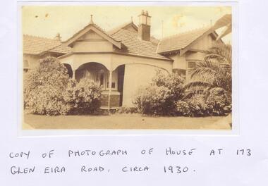
Letter - Maher, Francis Patrick
Correspondence between Mr Frank Maher and Felicitie Ampbell re information about a property at 173 Glen Eira Road, St Kilda East. Included is a copy of Frank Maher’s recollections of people and places around east St Kilda area. Also includes a copy of a photograph of his childhood home c. 1930 and a map of the area around the property where he lived.st kilda east, elsternwick, caulfield, myrtle street, bailey ave, atley grove, glen eira road, hotham street, glenhuntly road, elizabeth street, regent street, balaclava road, mcwhae ave, gordon street, ripponlea mansion, caulfield grammar school, caulfield race course, elsternwick police station, caulfield city hall, city of glen eira city hall, glen eira historical society, holy angels catholic church, st. josephs catholic church, a.r.p. wardens, drill hall, brighton rifles, grocers, sweet shops, terrace houses, tennis courts, saddlers, billiard rooms, horse drawn vehicles, market gardens, motor cycles, fuel merchants, maher frank, tracey martin brian, tracey john edmond, tracey margaret, maher mary eleanor, maher martin john, tracey kathleen, bent thomas, nathan benjamin -
Glen Eira Historical Society
Article - Grand Union Tramway Junction, Balaclava Road and Hawthorn Road
This file contains three items. 1. A three-page Caulfield Conservation Study of the Balaclava Road/Hawthorn Road Tramway Crossing, undertake by Andrew Ward and dated September 1994. Study includes a brief history of the junction and a statement of significance. Study also includes Four black and white photographs of the junction and of architectural details of the tram tracks. 2. A letter from the Conservation Manager of the National Trust of Australia (Victoria) to the manager of the Planning Section for the City of Glen Eira, dated 15/06/2001 and attached to a six-page Classification Report. The letter informs of the Classification of the Grand Union Junction at the intersection of Balaclava and Hawthorn Road by the national trust, signed by Conservation Manager Ian Pausacker. Classification Report includes details such as the date of construction, a statement of significance, history of the junction, physical description of the junction and the condition of the junction at the time of writing. Report also includes a map of the Melbourne Tram Network drafted by Keith Kings and dated 01/005/1956, with illustration of the layout of fifteen tram depots, and updated aerial illustration of the Grand Union Junction, and a further map of Melbourne Tramways developed by North Melbourne Electric Tramways and Lighting Co. and Prahran and Malvern Tramways Trust, drafted by Keith Kings and dated January 1914 with illustrations of three tram depots. 3. Two articles from the Caulfield Leader written by Aaron Langmaid and dated 13/02/2007 and the Melbourne Bayside Weekly dated 21/02/2007 written by Joanne Sim, both concerning the Grand Union Junction. The article from the Caulfield Leader includes a picture of Executive Officer of the council of Tramway Museum of Australia Craig Tooke in front of the intersection. The article from the Bayside Weekly includes a picture of a tram passing through the junction and a brief history of the junction and tram network in Caulfield. The article also refers to twp local tram shelters at the intersection of Dandenong Road and Alma Road and also Orrong Road and Balaclava Road.caulfield, caulfield conservation, study, balaclava road, hawthorn road, grand union junction, ward andrew, tramway crossings, transport, acland street, caulfield racecourse, tram tracks, race events, event, tram routes, thorough fares, melbourne and metropolitan tramways board, prahran and malvern tramway trust, prahran and malvern district tramways, caulfield electric tramways, caulfield city council, architectural detail, city of glen eira, balaclava road and hawthorn road intersection, balaclava road and hawthorn road junction, dandenong road, glenhuntly road, four-way tram junctions, access covers darling road, cast metal access covers, hadfields patent, caulfield park, tram systems, tram networks, heritage, tramway heritage, kings keith, tram depots, glenhuntly depot, maps, glen eira, melbourne electric tramways, north melbourne electric tramways and lighting co., prahran and malvern tramways trust, caulfield leader, bayside weekly, tooke craig, tourist attractions, grand union tramways junction, caulfield junction, cable car tramways, tram shelters, building, sheds, alma road, orrong road, caulfield electric line, balaclava junction, elsternwick railway station, caulfield station, caulfield station loop, tram services, transport establishments, thoroughfares, buildings, structures, establishments, parts of buildings or structures, documents, commercial industry, sites, historic sites, melbourne bayside weekly -
 Glen Eira Historical Society
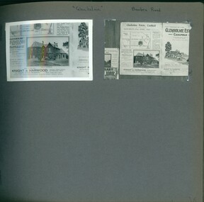
Album - Album page, Glenholme, Bambra Road, Circa 1972
This photograph is part of the Caulfield Historical Album 1972, showing an advertisement for the 21/04/1923 Glenholme Estate sale through real estate agents Knight and Harwood. This album was created in approximately 1972 as part of a project by the Caulfield Historical Society to assist in identifying buildings worthy of preservation. The album is related to a Survey the Caulfield Historical Society developed in collaboration with the National Trust of Australia (Victoria) and Caulfield City Council to identify historic buildings within the City of Caulfield that warranted the protection of a National Trust Classification. Principal photographer thought to be Trevor Hart, member of Caulfield Historical Society. Most photographs were taken between 1966-1972 with a small number of photographs being older and from unknown sources. All photographs are black and white except where stated, with 386 photographs over 198 pages. This polychrome brick and slate-roofed mansion was built by John Hart in 1871. Later owned by James McDougall (partner in Sands and McDougall; director of the first Caulfield horse tram company). Later again, it became a psychiatric hospital; demolished c1923.Page 36 of Photograph Album with two photographs of Glenholme Estate advertisements.Handwritten: "Glenholme" Bambra Road [top] / 36 [bottom right]trevor hart, caulfield north, bambra road, glenholme, advertisements, glenholme estate, knight and harwood, real estate agents, maps, polychrome bricks, slate roofs, john hart, james mcdougall, psychiatric hospitals -
Glen Eira Historical Society
Plan - Pritchard Steam Power Company
This file contains one item: 1/A draft of a plan for a museum exhibit from the Spirit of Enquiry Workbook, by Denis Shephard, and dated 07/08/2007, pertaining to alternative energy research within the suburbs of Melbourne between 1950 and 1980. Much of the content is irrelevant to Glen Eira. However; one of the two principle subjects of the exhibit, discussed between pages 20 and 28, is the work of Ted Pritchard, who was based out of Caulfield. Ted and his father, Arnold Pritchard, aspired to reinvent the steam engine for use within the contemporary era. To that end, they fitted a Chevrolet pickup truck with one of their prototypes – with the result being one of the main items constituting the exhibit. Ted’s interest in steam power had been spurred by a working tabletop model of a steam engine that Arnold built for him – which constitutes another of the exhibit’s items. Also included is a brief history of the development of Caulfield. The plan is embellished with numerous images, with relevant ones including maps of Caulfield and black-and-white photographs of the Pritchards’ truck, model and workshop.engines, engineering, engineers, inventions, inventors, steam engines, steam power vehicles, pritchard ted, pritchard arnold, pritchard steam power company, caulfield, shephard denis, pritchard mrs., trucks, pritchard edward, holland grove, balaclava road, workshops, grants, pritchard automotive steam designs, caulfield racecourse, caulfield technical school, caulfield trades school, caulfield technical college, chisholm institute, camden town, southdown knitting company, home street, fl hutchison, fowler street, vale knitting mills, nepean road, winterfold spinning mills, acme knitting mills, glen eira road, mj ryan knitwear, leather industry, lane joseph, hotham street, casey william, glen huntly road, pickering william, paris leather manufactory, woorayl street, tv tatchell, premier wire works, webb street, chesterfield ha, manufacturing industry, victory milk plant, bl coram & sons -
Glen Eira Historical Society
Document - GLEN EIRA ACTIVITY CENTRES
This file contains three items pertaining to the draft of the Glen Eira Activity Centre Strategy, each dated 11/2004 and composed by Peter McNabb and Associates Pty Ltd. (Unknown author of handwritten notes by John Campbell, Mayor of Caulfield 1986-87 and long-time observer of the Caulfield Council/Glen Eira Council): 1/A 53-page Overview Report, summarising the research conducted into the existing state of Glen Eira’s Activity Centres for the purposes of devising a Strategy to improve them. The Report constitutes the first of four components of a broader document termed the ‘Position Paper’, of which the remaining three are not present. The Report is divided into ten sections. The first is an executive summary of the entire document. The second is an introduction that explains the reasons why the Glen Eira City Council chose to embark upon this project. The third describes the methodology by which the research was conducted. The fourth describes what an Activity Centre is defined as. The fifth describes pre-existing policies and strategies pertaining to commercial development. The sixth describes the regional context of Glen Eira’s Activity Centres. The seventh describes the factors affecting Glen Eira’s Activity Centres plus the changes resulting from them, and is divided into four subsections pertaining to demographics, economics, decentralisation and housing, respectively. The eighth describes patterns of activity within Glen Eira’s Activity Centres, containing, for example, tables illustrating the number of particular types of businesses within each Centre. The ninth describes the new classification system for Glen Eira’s Activity Centres, the category each of Glen Eira’s Activity Centres belongs to under this system, and the future roles of each of the Centres. The tenth briefly recaps the entire document. Also included are three colour maps of Glen Eira noting the locations of existing Activity Centres. Handwritten notes and queries feature throughout, but the author thereof is unknown. 2/A 37-page Consultant Report issued for public comment, describing the draft of the Strategy to improve Glen Eira’s Activity Centres that has been formulated based on the data outlined in the Position Paper. The report is divided into six sections. The first is an introduction. The second describes the methodology used to develop the Strategy. The third describes the vision of Glen Eira’s Activity Centres plus the objectives necessary to achieve it. The fourth describes the new classification system for Glen Eira’s Activity Centres, the category that each of Glen Eira’s Activity Centres belongs to under this system, and future roles of each of the Centres. The fifth describes the improvements recommended for the Centres, and is divided into six subsections pertaining to land use, building renovations, street renovations, public transport, traffic plus parking, and marketing plus management, respectively. The sixth, finally, describes the amendment that ought to be made to the Glen Eira Planning Scheme on account of the Overview Report. Also included is a black-and-white map of Glen Eira noting the locations of existing Activity Centres. Again, handwritten notes and queries feature throughout, but the author thereof is unknown. 3/A 3-page summary of the draft, briefly outlining what the strategy is, why it has been prepared, what an Activity Centre is defined as, what the major influences of Glen Eira’s Activity Centres are, how the community has been consulted, what the key findings of the research process have been, what the process from here shall be, and how one can comment on the Strategy. Also included are three colour maps of Glen Eira noting the locations of existing Activity Centres.glen eira, city of glen eira, glen eira activity centre strategy, glen eira activity centres strategy, activity centres, peter mcnabb & associates pty. ltd., peter mcnabb and associates pty. ltd., glen eira city council, glen huntly, ormond, mckinnon, gardenvale, caulfield park, caulfield, murrumbeena, beauville estate, murrumbeena road, oakleigh road, carnegie, neerim road, hewitts road, ormond, koornang road, leila road, north road, caulfield park, kooyong road, gardenvale road, elsternwick, patterson, mckinnon road, bentleigh, alma village, phoenix precinct, parnell street, commercial development, commercial strategy, town planning, melbourne 2030, glen eira planning scheme, local planning policy framework, municipal strategy statement (mss), demography, economics -
Glen Eira Historical Society
Document - CAULFIELD RSL
This file contains two items pertaining to the property housing the Caulfield RSL: 1/A photocopy (2 pages) of an assessment of the property, dated 01/1997, by Andrew Ward, for purposes of ascertaining its historical significance. The assessment describes the architectural features of the property, offers a brief history of it, specifies why it should be considered significant, and recommends that it be added to the National Estate Register. Included is a black-and-white photograph of the exterior of the building. 2/An assessment (17 long pages plus appendix) of the car parking issues procured as a result of the decision to refurbish the Caulfield RSL. Prepared by Grogan Richards Pty Ltd, dated 13/11/2002, reviewed by Joanna Gauetty, and authorised by Rody Jude. Included is a description of the Club’s location and surrounding motorways as they existed at the time, a description of the Club itself (eg its opening hours and rate of patronage as per each opening hour), occupancy surveys, descriptions of other recent car parking construction within the same area, a description of the extensions the RSL is aiming to construct, and descriptions of the considerations any new construction must take into account. Included is a black-and-white map of Caulfield noting the RSL’s location, and two black-and-white photographs showing the view to the north and south of St. George’s Road, respectively.caulfield, caulfield returned servicemen league (rsl), exservice organisations, clubs and associations, ward andrew, glen eira heritage management plan, historic buildings, architectural, styles, national trust company, st. leonard’s, elsternwick club, grogan richards pty ltd, returned servicepeople, armed forces, soldiers, aged people, senior citizens centres, st. george’s road, elsternwick, english domestic revival style, moderne style, brick houses, bay windows, architectural features, prendergast ellen mrs., ford grylis, dl design group, gauetty joanna, jude rody, parking, glen eira planning scheme -
Glen Eira Historical Society
Document - Moorabbin Transit
This file contains one item: 1/A Moorabbin Transit printout of the bus timetable information for Route 822, effective 05/08/2002. Includes a description and a map of the route.princes highway, murrumbeena road, sydney street, hobart road, neerim road, crosbie road, north road, malborough street, stockdale avenue, gardeners road, quinns road, east boundary road, murrumbeena, bentleigh east, buses, bus stops, bus services, transport -
 Glen Eira Historical Society
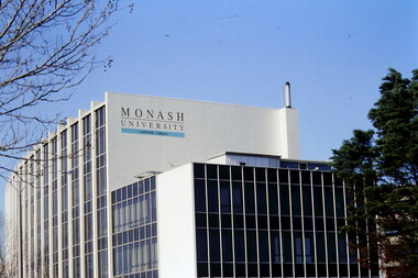
Article - MONASH UNIVERSITY CAULFIELD CAMPUS
This folder contains 6 items about this educational institution: 1/Undated colour slides showing various angles of two different building facades of Monash Caulfield Campus. 2/Article 'Martens Matters' re launch of exhibition of covesr of OASE 33 Magazine by Designer Karel Martens. Date noted as 01/04/2011 in 'The Age'. 3/Collection of 6 separate cards, all Priority Development Panel Submissions, Design Visualization, dated May 2006 (Architectural drafts) dated 31/03/2006 plus 2 identical cards dated 01/05/2006 - all drawings and one plan for NHArchitecture. 4/Collection of 4 colour separate cards, all Priority Development Panel Submissions, Design Visualization for Architect Wojciech Huszek of existing buildingsdated 31/03/2006. 5/Collection of 4 colour separate cards all Priority Development Panel Submissions, Design Visualization of existing buildings by photographer Andrius Lipsys, dated March 2006. (No architect stated.) 6/Article 'Uni rank sign of the Times' from Glen Eira Port Phillip Leader dated 12/03/2013 concerning Monash University’s world ranking in 100 best universities.nharchitecture, altoon and porter (master planner and urban designer ), huczek wojciech (architect), lipsys andrius (photographer), martens karel, station square development, campus map, derby lane, princess lane, post office place, caulfield station, sir john monash drive, derby road, the hub, the mat, post office square, station square, zagame’s hotel, dandenong road, oase 33, art and design building, monash university, caulfield campus, caulfield east, universities, tertiary education -
 Federation University Historical Collection
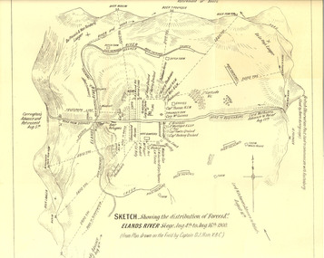
Plan, Sketch of Elands River Siege, 1900
... River siege. Map details surrounding hills, roads, rivers...://trove.nla.gov.au/ndp/del/article/11023251 boer war map sketch victorian's ...Plan based on the field notes of Captain David John Ham, V.B.C. For article written by Ham on the event, see http://trove.nla.gov.au/ndp/del/article/9542500 For obituary of Ham, see http://trove.nla.gov.au/ndp/del/article/11023251Sketched paper map of forces' distribution at the Elands River siege. Map details surrounding hills, roads, rivers, and names all soldiers involved in siege. boer war, map, sketch, victorian's bushmen contingent, hocking, fowles, methuens, david john ham -
 Federation University Historical Collection
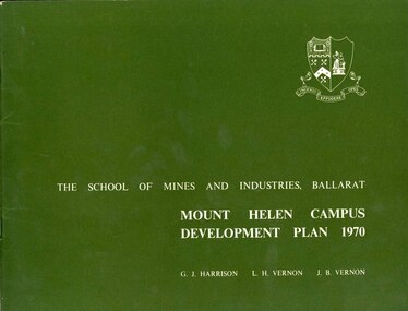
Book, Mount Helen campus Development Plan 1970, 1970
Green and white soft covered booklet of 48 pages. SMB Crest is on the front cover. The content include the Mt Helen site, site planning, student residences, sporting facilities, roads and parking, pedestrian circulation, engineering services, and landscaping. Illustrations include: Plan of Mt Helen Site (July 1969, existing buildings, Functional relationship, Roads and Parking, Pedestrian Circulation, engineering Services, Landscaping, Development Plan, Plan of Academic area, Library and union Courtyards, Birds Eye View of Academic Area from north-west, etc. the master plan projects student numbers.non-fictionuniversity of ballarat, ballarat institute of advanced education, mount helen, master plan, landscape, harrison, vernon, great hall, geoff harrison, john vernon, m.b. john, contour map, student accomodation, landscaping, development plan, campus plan -
 Federation University Historical Collection
Book, Selection of Geological Publications, 09/1866
This book was owned and used by Professor Ferdinand M. Krause of the Ballarat School of Mines.Ferdinand Krause was a renowned teacher at the Ballarat School of Mines. He also produced many important Geological Maps. This book has seven reports that Krause had bound together for his own use. Half black leather bound book with hand marbled paper cover. Marbling on cover is grey, maroon and darker grey with gold bands on black leather spine. The book contains 7 papers on various subjects associated with ores. The book includes: 1. Auriferous, Leads, & Silver Ores at Upper Hungary - G.H.F. Ulrich, 1868 2. Nuggetty Reef, Maldon, Victoria - G.H.F. Ulrich, 1866 3. Internal Communication - Lieut. Amsinck, 1856 4. Roads for Victoria - William Macredie, 1856 5. Mining & Mineral Statistics of Victoria - Robert Brough Smyth, 1866 6. Physical Geography & Geology of Victoria - R.C. Selwyn, 1866 7. Mineralogy of Victoria - G.H.F. Ulrich, 1866 Leather component is black with gold bands on spine with "Silver Ores etc" written on spine. 'G" on square cream paper at top of spine; "2" on square cream paper on middle of spine; and "3" on square cream paper on bottom of spine. Inside front cover on red paper rectangle near spine "bound by W. PAUL 17 Lydiard St BALLARAT" "Ferdinand M Krause C E" handwritten in black ink on title page of first paper (right hand side)treatment, auriferous, lead, silver ores, nuggetty reef, maldon, victoria, internal communication, roads for victoria, mining, mineral statistics, geography, geology, mineralogy, ulrich, amsinck, selwyn, ferdinand krause, macredie -
 Federation University Historical Collection
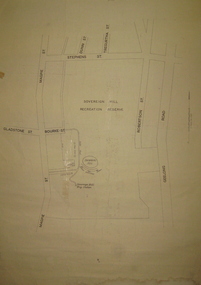
Plan, Sovereign Hill Recreation Reserve and Surrounds
This map was probably produced around the time that the Sovereign Hill Museums Association was established. A simple plan with black marking on paper. It shows the Sovereign Hill Recreation Rerserve, including the swimming pool located near the Sovereign Hill Trig Point, showers, toilets, kiosk, bandstand and pine trees. The plan also depicts the Ballarat East streets surrounding Sovereign hill, including Geelong Road, Magpie Street, Stephens Street, Tregurtha Street, Dunn Street, Bourke Street, Gladstone Street and Robertson Street. The scale is 2 chains to 1 inch.sovereign hill, swimming pool -
Federation University Historical Collection
Plan - Plan (copy), Melbourne Road Ballaarat, 1857
This map shows the vicinity of the site of the Eureka Stockade. A3 black and whole photocopy of a plan of Ballarat's Melbourne Road. The plan shows Melbourne Road, Proposed Melbourne Road (later Eureka Street), Chamberlain Street, Queen Street, Allotments between Rodier Street and Stawell Street (William Collard Smith, J & T Oddie, F.A. Edward A. Wynne, David Fitzpatrick, Robert Walsh, Charles Spencer, Alfred Lester, Free Trade Hotel)william collard smith, oddie, wynne, fitzpatrick, walsh, spencer, lester, free trade hotel -
Federation University Historical Collection
Plan (copy), Frederick Proeschel, Map of the Roads to all the Gold Mines in Victoria, 1853
... The map was pirated from Frederick Proeschel's "Pocket Map...Digital file of the Map of the Roads to all the Gold Mines... was pirated from Frederick Proeschel's "Pocket Map of the Roads to all ...The map was pirated from Frederick Proeschel's "Pocket Map of the Roads to all the Gold Mines in Victoria" issued earlier in 1853.Digital file of the Map of the Roads to all the Gold Mines in Victoria. The map has been coloured to show routes to the Victorian goldfields from Melbourne and Geelong.frederick proeschel, proeschel, gold, mining, philp -
 Federation University Historical Collection
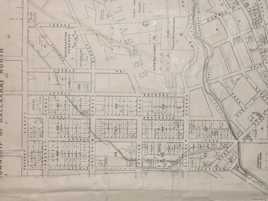
Map, Municipality of Ballarat East, 1857
Gold was discovered in Ballarat in 1851. This plan was created six years later and names some of the great gold locations of Ballarat East. It also shows the locality of the Eureka Stockade (1854) and the walking tracks and roads on the Ballarat East Goldfield.In 2007 this map was listed on the inaugural Ballarat Treasure's Register.Large map backed onto linen. The map has read and blue highlights, and identifies areas such as Mount Pleasant, Golden Point, White Flat, Nightingale, Malekoff, Old Post Office Hill, Red streak, Gumtree Flat, Old Gravelpits, Bakery Hill, Ballaarat Flat, The Camp, Specimen Gully, Pennyweight Hill, Warrenheip Gully, Gays Gully, Pennyweight Flat, Eureka, Black Hill, Pinchgut, Crocodile, Hit or Miss, Little Bendigo, Brown Hill, Mopoke, Cricket Reserve, Canadian Hotel, Ballarat Eastmount pleasant, golden point, white flat, nightingale, malekoff, old post office hill, red streak, gumtree flat, old gravelpits, bakery hill, ballaarat flat, the camp, specimen gully, pennyweight hill, warrenheip gully, gays gully, pennyweight flat, eureka, black hill, pinchgut, crocodile, hit or miss, little bendigo, brown hill, mopoke, cricket reserve, canadian hotel, ballarat eastm phillips, john phillips, field draughtsman, ballarat east, ballarat east map -
Federation University Historical Collection
Letter - Photocopy of letter, Letter regarding the naming of Vincent Drive, Mount Helen, 1984, 1984
Provides information about the naming of Vincent Drive Ballarat University 1984. Vincent Drive was named in recognition of the years of service Richard Vincent gave to the Shire of Buninyong as a councillor.Photograph of letter plus a Ballarat University campus map showing Vincent Drive, plus a newspaper clipping and photocopy of the clipping regarding a new access road to the Ballarat Technology Park ( The Courier, Ballarat, Tuesday, March 19,1996).vincent drive, federation university, buninyong shire, ballarat university, ballarat technology park -
 Federation University Historical Collection
Plan, City of Ballarat (Part) (Ballaarat East), 08/05/1928
Crown Cadastral Plan showing Governement Roads, Crown Parcels, Dimensions, Crown grantees, dated of grants, etc in Ballarat East. The plan shows features such as Bakery Hill, Canadian Station, recreation reserves, timber reserves, Yarrowee Creek, Black Hill Reserve, Eureka Reserve and Garden, Orphan Asylum, Rifle Butts Reserve, Ballarat Woollen Mill, Ballarat Observatory, Sovereign Hill Recreation Reserve, Specimen Vale, Market Reserve, Cemetery WGS 84 Centroid 37 degrees 33' 55" S 143 degrees 52' 38" E E.W. Extent; 5 km N-S Extent; 4 kmmap, plan, ballarat east, ballarat woollen mill, ballarat railway line, ballarat railway station, eureka reserve, eureka cemetery, ballarat orphanage, russell square, bakery hill