Showing 1784 items matching "settlement."
-
 Ballarat Tramway Museum
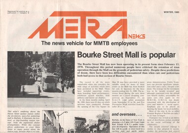
Magazine, Melbourne and Metropolitan Tramways Board (MMTB), "Metra News - Winter 1980", 1980
Single sheet of paper, folded to from a four page newsletter, titled "METRA News, the news vehicle for MMTB employees" and dated Winter 1980. Has the title printed in red ink and uses the same colour for other titles for items with the newssheet.. Items of interest: 1. Bourke St. Mall 2. Senior citizens help design new tram - Z3 class trams 3. Bus only lane in Johnston Street 4. Education of City Police 5. An extensive item on people, new employees, promotions - including the promotion of BTM Board Member Greg Rodgers to Trainer Drivers at Camberwell. A number of these people have been underlined or circled in red ink. 6. Depot employees' social and facility fund 7. Profile on R.C.Dummond, Traffic Manager 8. Wilbur's corner - a review of out of court settlements for accidents. 9. Two cartoons by AugustineRed ink circling or underling specific employee names in the people section.trams, tramways, mmtb, bourke st, bus only lane, accidents -
 Kew Historical Society Inc
Plan - Subdivision Plan, Normanby Heights Estate, Kew, 1919
Prue Sanderson, in her groundbreaking ‘City of Kew Urban Conservation Study : Volume 2 - Development History’ (1988), summarised the periods of urban development and subdivisions of land in Kew. The periods that she identified included 1845-1880, 1880-1893, 1893-1921, 1921-1933, 1933-1943, and Post-War Development. These periods were selected as they represented periods of rapid growth or decline in urban development. An obvious starting point for Sanderson’s groupings involved population growth and the associated economic cycles. These cycles also highlighted urban expansion onto land that was predominantly rural, although in other cases it represented the decline and breakup of large estates. A number of the plans in the Kew Historical Society’s collection can also be found in other collections, such as those of the State Library of Victoria and the Boroondara Library Service. A number are however unique to the collection.The Kew Historical Society collection includes almost 100 subdivision plans pertaining to suburbs of the City of Melbourne. Most of these are of Kew, Kew East or Studley Park, although a smaller number are plans of Camberwell, Deepdene, Balwyn and Hawthorn. It is believed that the majority of the plans were gifted to the Society by persons connected with the real estate firm - J. R. Mathers and McMillan, 136 Cotham Road, Kew. The Plans in the collection are rarely in pristine form, being working plans on which the agent would write notes and record lots sold and the prices of these. The subdivision plans are historically significant examples of the growth of urban Melbourne from the beginning of the 20th Century up until the 1980s. A number of the plans are double-sided and often include a photograph on the reverse. A number of the latter are by noted photographers such as J.E. Barnes.The Normanby Heights Estate not unusually used hyperbole to attract purchasers to the auction of 17 lots facing Argyle Street (sic), Pleasant Avenue and Normanby Road. Predictably factors appealed to included the proximity to schools etc, the availability of public utilities, friable soil, picturesque views and ‘advancing settlement’. If that were not enough, the sales pitch exhorted prospective purchasers to consider their backbone. ‘Thrift is unquestionably the Backbone of any Nation. No better form of Thrift can be encouraged in the young citizen than by investing his or her savings in a piece of land in a growing, healthy and beautiful locality. NORMANBY HEIGHTS ESTATE admirably fits the need.’ The experience of Australia at war undoubtedly contributed to the use of terms such as ‘Backbone of a Nation’ and the appeal to egalitarian principles in the choice of the term ‘young citizen’. The recognition that women had savings and might be the prospective purchaser also reflects a new sense of the rights and entitlements of women in the postwar period.subdivision plans - kew, normanby heights estate, pleasant avenue, normanby road, argyle street -
 Glenelg Shire Council Cultural Collection
Artwork, other, BRIGIT THOMAS, Lady Nelson, c. 2015
From - theladynelson.org.au T The original Lady Nelson was built at Deptford, in England, in 1799, for service to the Transport Office on the River Thames. She was designed with sliding keels (centre boards), a device invented by Captain John Schank of the Royal Navy to allow surveying in rivers and shallow water ways. On completion she was selected for exploration services in the Colony of New South Wales and sailed for Port Jackson on 18 March 1800 under the command of Lieutenant James Grant. A brig of 60 tons, she carried a crew comprising the commander, two mates and twelve seaman. As she left the River Thames sailors on nearby ships ridiculed her because of her size and shape, calling her, as she sailed past, 'His Majesty's Tinderbox'. At Portsmouth on the 9th February 1800 she was fitted with four brass carriage guns, three to four pounders, in addition to the two guns already on board. Because of the heavy load she was carrying she was very low in the water, having only two feet nine inches freeboard amidships. The ship finally left Portsmouth on 17th March 1800 as part of an East Indian Convoy. From 1800 to 1825 the Lady Nelson operated around the Australian Coast and fulfilled a variety of roles including exploration, surveying, forming settlements, shifting goods and people around the colonies and capturing pirates. She played pivotal roles in the European settlement of Hobart, Northern Tasmania, Melbourne, Newcastle, Port Macquarie and Northern Territory. Those onboard charted much of Bass Strait, Port Philip, Newcastle, Port Macquarie and (with the Investigator) the coasts of northern New South Wales and southern Queensland. She also has links to other locations around the East Coast such as Trial Bay in NSW and the Mt Gambier area of SA. After 25 years of service while trading on the island of Baba the Lady Nelson was overrun by the islanders, the crew was killed and the ship stripped and later burnt and sunk. A replica of the Lady Nelson was built in the 1980s.Image of a tall ship in sail. The ship is flying both the Aboriginal flag and the Australian Flag. It sails on a calm sea. There are figures on the deck - four in total. The image is mounted on cream board and framed in dark timber. Etching, hand coloured,.Front: 'Lady Nelson A/P BT' - hand written, pencil in between etching and mount Back: Artist's business card glued to back of etching, lower left hand corner:ady nelson, femal artists, female artist, women -
 Glenelg Shire Council Cultural Collection
Painting, Robert Ulmann, Goat, c. 1974
Robert Ulmann was born in Zurich, Switzerland, where he studied sculpture and painting, exhibiting annually with the National Art Society of Switzerland and in Paris, Munich and Stockholm. He migrated to Canada in 1956 and became a Canadian citizen. After working on the restoration of sculpture on the west wing of the Parliament Buildings Ottawa, he took up a Government appointment as one of six artist advisers to the Eskimos, initiating handicraft and sculpture programs in isolated settlements across the Central Arctic. He arrived in Australia with his Australian wife, Helen, in 1969, after two adventurous years backpacking and sketching through the United States, Central and South America and the South Pacific. From 1970 to 1972 he was employed by the Northern Territory Administration as a manual arts instructor to the aboriginal people of Docker River, a remote settlement west of Ayers Rock. A series of drawings from this period was exhibited by the Department of the Interior in Canberra, Sydney and Adelaide. Robert Ulmann’s paintings and prints of wildlife from Australia and overseas fill a beautiful studio overlooking the famous Logans Beach whale nursery at Warrnambool in the Western District of Victoria. His previous studio and home, together with 13 years of field sketches and his best work collected together for two books were destroyed by the Ash Wednesday fires at Naringal in 1983. Rob exhibited in Sydney, Melbourne, Adelaide and Perth as well as in the Regional Galleries of Warrnambool, Ballarat, Portland and Horsham, and, among numerous prizes, he won the award for watercolour at six of the annual exhibitions of the Wildlife Art Society of Australasia, between 1978 and 1983. Although his principal interest was in drawing and painting, he retained a fascination with sculpture. His works range from two stone fountains with figures commissioned by the City of Zurich, while he was still a student, to a 4 ½ ton sculpture in bluestone commissioned in 1977 as a memorial to Sir Fletcher Jones., a five metre representation of whale tails in steel, and a life-size bronze of St. John of God commissioned for a private hospital.Image of a goat beginning to rise from a seated position, possible struggling out of mud. Painted in yellow and brown tones, with blue shadows. Earth colours form a rough ground area surrounding the goat. A brown wash provides a cursory background behind the goat's head. Dark cream matt surrounds image. Gold painted wooden frame, with glass.Front: Robert Ulmann (lower centre, paint) Back: (no inscriptions) -
 Orbost & District Historical Society
black and white photograph, 1918
Tonghi Creek is 66km north - west of Orbost. Prior to the sealing of the Princes Highway west of Orbost, the road surface was anything but good, even by C1917 when cars started to use the road. From Orbost the old road via Marlo to Sydenham was abandoned for the new location which traversed more rugged country via Cabbage Tree, Bell Bird and Club Terrace to Cann River, and the reason for this diversion was on account of settlements being established at Murrungowar and Club Terrace, at which latter place there was a temporary rush to obtain gold. This road was constructed by the Public Works department and a maximum grade of 1 in 19 was adopted, and as speed was not to be catered for the grade followed in and out round the spurs and gullies, resulting in a maze of turns and twists which required a good deal of skill on the part of the horse driver to negotiate." - Bairnsdale Advertiser, Friday, May 2, 1947. (More information from Newsletter February 2010)This item is a pictorial record of roads in the early 20th century in East Gippsland.A large black / white photograph of a bridge over a small creek, surrounded by bush. The photograph is mounted on a thick cream coloured card.on back - "Bridge at Tonghi Creek 1918"tonghi-creek-bridge country-roads-east-gippsland -
 The Beechworth Burke Museum
Photograph
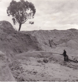
This photograph depicts a man in dark clothing, standing in front of a cut away section of earth. He is undertaking hydraulic sluicing, which involves the use of high powered hoses, in order to cut away the earth which can then be sifted for gold. There is a single tree in the background and the earth contains numerous signs of damage because of the mining. Beechworth become a mining settlement after the discovery of gold in 1852. Gold fever had already spread across Australia's colonies and the American states. Sluicing the landscape for gold, as shown in this photograph, was done by diverting water and washing away the lighter dirt, allowing the gold particles to sift down in to catchments for collection. In Beechworth, there was considerable discontent caused by attempts to restrict water use for sluicing to those with certain 'water rights'. The extensive use of hydraulic sluicing, and the washing away of top soils has continued to impact the surrounds of Beechworth in to the present day. Sluicing as a method for gold mining which was widespread across Victoria during the 1870s. The erosion of the top soil in search of gold has a continuing environmental impact on the landscape and this photograph depicts but one example of this occurring and can provide much information to a researcher interested in understanding the history of gold mining in Victoria. This image of the miner and hose is historically important because it demonstrates the methods of goldmining employed in the later years of the goldrush at Beechworth. It shows how much land is washed away by the use of this technology. The image has good interpretive capacity because it allows researchers to see a different mining technique to what is usually presented. Black and white square photograph on card.reverse: 84-50-3 / 1997 3141 / smdsluicing, goldmining, beechworth, burke museum, miners, gold miners, gold sluicing, environmental impact -
 Warrnambool and District Historical Society Inc.
Document, Wollaston sale, 1919
This is a poster advertising the sale of part of the Wollaston Estate in Warrnambool in 1919. The sections for sale were Allotments 1, 18 and 19 which included the Wollaston Homestead. The original Wollaston property of 679 acres was selected by Thomas Manifold in the late 1840s. This land, on the northern side of the Merri River, near the Woodford Road was three kilometres from the Warrnambool town. The first farmer we know who leased the property was William Simpson. Walter Manifold inherited the property and he took it over in 1884. The swing bridge he built in 1890 still stands today. In 1919 the Closer Settlement Board of Victoria acquired Wollaston and 17 lots were sold to returned soldiers for farming purposes. By 1930 there were only five soldier settlers remaining. In 2009 further subdivision took place with lots sold for residential purposes. The homestead allotments were sold separately in 1919 with various owners of the homestead itself recorded since that time. This poster is of interest as it shows the areas of the Wollaston Estate which were sold in 1919. The history of this estate is well-documented and of importance in the history of Warrnambool. This is a sheet of paper with red and black printing and a map of the Wollaston Estate which is photo-lithographed. The sheet has been folded three times. It has some small tears at the top of the page. wollaston, history of warrnambool, walter manifold -
 Kiewa Valley Historical Society
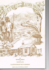
Book - A History of the Kiewa Valley, Kiewa Valley Historical Society, A History of the Kiewa Valley by Esther Temple and David Lloyd, Circa 1991
This book was compiled by Esther Temple and David Lloyd with illustrations by Betty Barberis and additional material provided by Clare Roper, Joan Macdonald, Wilma Davies and Nell Bateman. The book was first penned in 1971. It briefly covers the period from the indigenous tribes(broken down into family groupings) known as the "first Australians" who lived in the valley well before English settlers arrived. first white settlement (graziers, miners, stockmen) to smaller settlements.The development or transformation from a pristine(hunter/gatherer) valley environment to one that has been gradually changing to a more commercial rural/industrial landscaped valley. This transformation was made within a time span of two hundred years. The book details the first pioneers and their descendants, along with the changes to their environments both domestic and commercial. The book highlights dates and events that shaped the "feel" of the valley. The extreme hardships faced by pioneer families during the extremely isolated times away from "civilisation".This publication provides an insight to the struggles and victories against the harsh Australian bushland by people who had not been raised in such a sometimes inhospitable environment. It was this transformation which instilled into the Australian psyche of self sufficiency and the ability to grasp onto ideas or "bush" remedies to overcome enormous difficulties. It is is ability that has produced the many inventions useful in the 20th and 21st centuries.This book has a 250 g/m cream coloured cover with print and drawings of rural aspects of historical significance ( Aboriginal and early white settlers). The book contains 124 pages of black and white photographs(139), black and white sketches(75), two pages of sketches and freehand drawings, two freehand maps one county lease /subdivision plan and black and white printing. See KVHS 0237 (B) for the official invitation to the launch of the book.The front top cover heading(in shaded print and enclosed in a banner form) "A HISTORY OF THE KIEWA VALLEY" The bottom printing "BY ESTHER TEMPLE & DAVID LLOYD ILLUSTRATIONS BY BETTY BARBERIS" and at the very bottom "KIEWA VALLEY HISTORICAL SOCIETY" oN THE BOOK SPINE "A HISTORY OF THE KIEWA VALLEY.....BY ESTHER TEMPLE & DAVID LLOYD"early settlers, dederang, tawonga, mount beauty, sec vic hydro electricity, falls creek early settlers, bonegilla -
 Warrnambool and District Historical Society Inc.
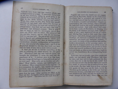
Book, Divine Conduct or the Mystery of Providence, Early to mid 19th century
This is a book, ‘Divine Conduct or the Mystery of Providence’ originally written by the Rev. John Flavel in 1677. This is a later edition with no date listed but it is presumed it was re-published in the 19th century. The book was given to Janet McGhie in 1849, the first anniversary of the Warrnambool Sunday School, just 14 months after the first European settlers arrived in the new settlement of Warrnambool. The first Sunday School in Warrnambool was located in McDowell’s Store and run by Thomas Denney and Richard Osburne. The latter in 1851 commenced Warrnambool’s first newspaper, the Warrnambol Examiner and in 1887 published an important history of Warrnambool. Janet Garden McGhie was the daughter of Matthew and Isabella McGhie who were pioneer settlers in Warrnambool. Janet McGhie married Alfred Coulstock at the age of 17 and died in Warrnambool in 1918 at the age of 80. She was aged 11 when she received this book and one wonders what she made of the ponderous text. This book is very precious as one of the few mementos we have of the very early days of Warrnambool’s settlement. It gives us a date for the establishment of the first Sunday School and the name of one of the award winners. It is also an interesting example of the pious and ponderous writings that young children were expected to read in the mid 19th century. It is presumed that at that time there would not have been a great choice of reading material available in Warrnambool to give to childrenThis is a hard cover book of 252 pages. The dark green cover has gold lettering on the spine which is almost obliterated. The cover is partly detached from its binding and is much stained and blotched. There is an inscription on the inside front cover in black ink and a red stamp of the Warrnambool & District Historical Society on the first page. There are some indecipherable pencil markings on this first page and the last page.‘Janet McGhee (or McGhie), 1st Anniversary Warrnambool Sunday School, Decr 3rd 1849’janet mcghie, warrnambool sunday school -
 Orbost & District Historical Society
programs, 1961
The Snowy River Shire was a local government area in the Australian Alps region of New South Wales, Australia from 1939 until May 2016. It was named after the Snowy River that runs through it. Prior to 1936, it had been named as Dalgety Shire since establishment in 1906. This opening of the Monaro - Gippsland Road took place on 4th May 1961. There had long been a movement in Monaro for the construction of a road to connect Monaro and Gippsland, via Inglebyra and Black Mountain. The only track was for stock, made by pioneers many years ago, and it was very circuitous. It was stated at a meeting at Dalgety that the road would open up large areas for settlement for grazing, and for timber suitable for bridgé building. The road would assist stock deal ing between Monaro and Gippsland. It would also considerably shorten the distance from Victoria for tourists visiting Canberra and Kosciusko. A committee was formed to put the proposal before the Dalgety Shire Council in the 1930s.This item is a useful research tool.Four copies of a road opening program. It has black print on white. There are black / white photographs, historical details and details of the official opening.program monaro-road snowy-river-shire -
 Orbost & District Historical Society
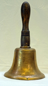
Functional object - Bell, hand-held, Early 20th century, c.1900s
The settlement of Cabbage Tree Creek is located on the Princes Highway, 27 km east of Orbost in East Gippsland. The creek, which flows through undulating forest, takes its name from the patches of Cabbage Fan palms growing along its course. A school commenced classes in 1913, but enrolment was small and at times the school operated part time with several other small schools in the area. The school building served as a hall for the district. About 1946 two sawmills commenced operations at Cabbage Tree Creek, and the Forests Commission ranger was stationed in the area. The increased population allowed the school to have more teachers and make improvements. In 1953, a new prefabricated building was erected on a new site. However, by the 1970s employment in the timber industry was unstable and the population decreased. By 1974 the school again had only one teacher and eventually closed in 1993 to amalgamate with the Orbost primary School in Ruskin Street, Orbost. (Ref. VictorianPlaces)The school bell is a signal that tells a school's students when it is time to go to class in the morning and when it is time to change classes during the day as well as when students are dismissed from school. In most schools today it will be a tone, siren, electronic bell sound, a series of chimes, or music played over an intercom but often still called "the school bell". This item reflects the history of Cabbage Tree Creek as well as the technological changes in the school system.Brass bell with incised double lines on bottom edge and top near handle, featuring descriptive notation on front face. Bell has long wooden handle shaped and incised with four lines at base before brass housing with singular screw holding handle in place. Object is showing signs of wear, with blackened handle and patches of green oxidisation.SCHOOL BELL / SS No 3812 / CABBAGE TREE CREEK / PRIMARY SCHOOL / 1913-1993 / FORMALLY INCORPORATED / INTO / ORBOST / PRIMARY SCHOOL / 1994cabbage tree, east gippsland, cabbage tree creek, cabbage tree creek primary school, orbost primary school, school bells -
 Mt Dandenong & District Historical Society Inc.
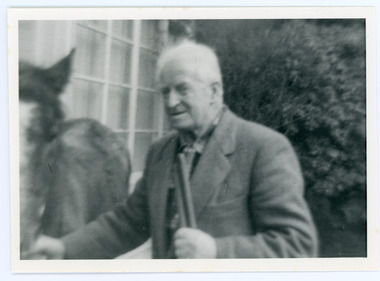
Photograph, Edward John Price 1973
John Lundy-Clarke grew up in the Kalorama/Mt Dandenong area and later in life (1972-74) began to write a comprehensive history of the district working from an original settlement map in an effort to cover all areas. Edward John Price (Ted)(1899-1974) was the third child of Edward Joseph and Annie Price. He lived a very industrious life in the area. When the new CRB road cut through the family land Edward John established a Corn and Produce store on a level area adjoining the new road . Along with his brother Charlie, Ted took up road contracting and formed Grange Road in 1923. They also took up contracts to metal the CRB road between The Gap and Olinda. Edward John married Myra Wilson in 1930. They lived in the first brick home built in the district. They had two sons, Edward Joseph 2nd and Alan.Black and white photograph showing an old man dressed in a jacket holding the reins of a horse. Reverse of photograph has handwritten description by John Lundy-Clarke.Edward John Price 1973. Son of Edward Joseph & Annie Ada nee Ross. Born 1899 died 1974. Farmer, Carrier, Sawmiller, Contractor, Quarry Owner, Shop Proprietor (Kew Junction 1935). Father of Alan & Edward J.edward john price, myra wilson, edward joseph price, annie price, alan price, charles price, grange road, crb road -
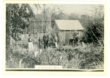 Mt Dandenong & District Historical Society Inc.
Photograph
The Keoghs took up Lot 7 in the Village Settlement in 1905. John Keogh was a big Irishman and cleared many of the giant trees on his Lot 7. They had little water for their crops so grew gooseberries and red currants rather than the more valuable strawberries. Mrs Keogh (nee Cleary) inherited money in 1906 and they built a new weatherboard house. The original bush hut remained as the kitchen. Son James (Jimmie) married Mary Walsh, a teacher at the local school. Jimmie built the small shop on the triangle of land cut off when the CRB road went through. Jimmie and his wife left the district when he joined Victoria Police. Jimmie came back to the area and finally sold the land of Lot 7 to Rimington's Nurseries. He moved his family to Kilsyth. In 1939 the shop was moved across the road to be used as an office by the road builders. It burned down that year.Black and white photograph of a man, woman and young male standing outside a wooden hut. There are crop remnants in the foreground and a wooden paling fence behind the hut. A label on the front reads A SETTLER'S HUT. Reverse of photograph has handwritten description by John Lundy-Clarke.Front: A SETTLER'S HUT Reverse: 1905 Keogh's hut on Falls Road then Main Road. This was later the kitchen of their extended home as described in the narrative "Mountain of Struggle". The figures are - Mrs Keogh. John Keogh settler. Son James Keogh.keogh, john keogh, james keogh, jimmie keogh, mary walsh, cleary, shop, store, gooseberries, rimington's nursery -
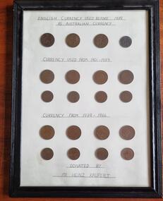 Wodonga & District Historical Society Inc
Coin - Currency in Australia pre Decimal
In the first years after European settlement of Australia, a varied collection of international coins, tradesmen's tokens and promissory notes were used by European settlers, while soldiers participated in the notorious rum trade. In 1825, the British government made the English Pound the only form of legal currency in Australian colonies. With Federation in 1901 the Commonwealth government became the only body with the constitutional power to issue currency. In 1910, nine years after Australia federated as a nation, a national Australian currency was formed, based on the British money system of pounds, shillings and pence. The Australian penny was first minted in England from 1911 to 1915, then in India from 1916 to 1918. Australia started minting most of its own pennies from 1919 until the introduction of decimal currency in 1966. This collection was donated by Mr. Heinz Kaupert of Wodonga. He was an active member of the German-Austrian club of Wodonga. He died in Wodonga in 2014.These coins reflect developments in Australian currency and were donated by a member of the Wodonga Community.A collection of 20 penny and half penny coins mounted in a frame behind glass. They are divided into 3 sections - English currency used as Australian Currency before 1939, Australian coins used 1901 - 1939 and currency used from 1939 - 1966.australian coins pre-decimal, australian penny, australian halfpenny -
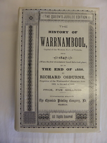 Warrnambool and District Historical Society Inc.
Book, The History of Warrnambool by Richard Osburne, 1980
Richard Osburne (1825-1895) came to Warrnambool in 1847, a pioneer resident in the new settlement. In 1851, with John Wilkinson, he founded Warrnambool’s first newspaper, the Warrnambool Examiner, and issued it weekly for some months until he left the town for the goldfields. Returning in 1853 he resumed publication of the Examiner and continued it, intermittently in its last few years, until 1880. He was acknowledged in his day as the Father of the Warrnambool Press and was a dominant figure in Warrnambool’s early history. He was associated with the establishment of the Aboriginal Reserves, Fire Brigade, Mechanics’ Institute, Warrnambool Council, National School, Presbyterian Church, Public Wants Committee, Villiers Building Society, Fish Protection Society, Dramatic Club, Cricket Club, Otway Gold Exploration Syndicate and other institutions. In 1882 he went to live in Melbourne, returning to publish his ‘History of Warrnambool’ in 1887, a Queen’s Jubilee publication. Richard Osburne’s book is a seminal work of the 19th century history of Warrnambool and its importance cannot be over-emphasized. The original copies of this book are now hard to get and are very valuable. This facsimile is kept because the facsimiles are also now becoming rare and they are good examples of the way a facsimile is reproduced and the reason for the existence of this particular reprint– the importance and usefulness of Osburne’s history and the need to make it accessible to researchers today.This is a facsimile edition (1980) of Richard Osburne's book on the history of Warrnambool from 1847 to 1886. It is a hard cover buff-coloured book with gold lettering on the spine. The dust cover is cream-coloured paper with black writing. Inside the cover is a map of southwest Victoria (1880). There are five fold-up inserts (sketches, diagrams etc), a number of business advertisements, sepia photographs and sketches and an index. The dust cover includes information on the author. There are 25 chapters, a foreword by the Prime Minister of Australia, Malcolm Fraser and a Preface The proceeds of the book reprint went to Flagstaff Hill Maritime Village.This is a facsimile edition (1980) of Richard Osburne’s book on the history of Warrnambool from 1847 to 1886. It is a hard cover buff-coloured book with gold lettering on the spine. The dust cover is cream–coloured paper with black writing. Inside the cover is a map of southwest Victoria (1880). There are five fold-up inserts (sketches, diagrams etc), a number of business advertisements, sepia photographs and sketches and an index. The dust cover includes information on the author. There are 25 chapters, a foreword by the Prime Minister of Australia, Malcolm Fraser and a Preface The proceeds of the book reprint went to Flagstaff Hill Maritime Village.richard osburne, the history of warrnambool, warrnambool examiner -
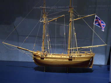 Flagstaff Hill Maritime Museum and Village
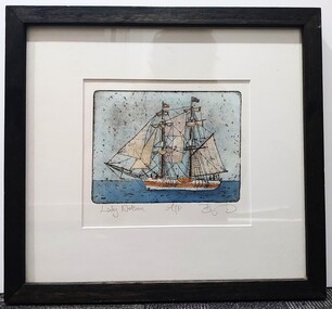
Craft - Ship Model, H.M.S. Lady Nelson, 1988
This model of the ship H.M.S. Lady Nelson was researched and built as the vessel Lady Nelson by David Lumsden, a professional ship model builder. His Majesty's Armed Survey Vessel Lady Nelson was commissioned in 1799 to survey the coast of Australia. This vessel was purpose-built before the British Admiralty requested plans for a Schooner for Port Jackson. At the time large parts of the Australian coast were unmapped and Britain had claimed only part of the continent. The British Government were concerned that, in the event of settlers of another European power becoming established in Australia, any future conflict in Europe would lead to a widening of the conflict into the southern hemisphere to the detriment of the trade that Britain sought to develop. Against this background, Lady Nelson was chosen to survey and establish sovereignty over strategic parts of the continent. Lady Nelson left Portsmouth on 18 March 1800 and arrived at Sydney on 16th December 1800 after having been the first vessel to reach the east coast of Australia via the Bass Strait. Before that date, all vessels had sailed around the southern tip of Tasmania to reach their destination. Lady Nelson's survey work commenced shortly after she arrived in Sydney, initially in the Bass Strait area. She was involved in the discovery of Port Phillip, on the coast of Victoria, in establishing settlements on the River Derwent and at Port Dalrymple in Tasmania. She also successfully chartered much of the Victorian coastline and was heavily involved with the exploration of the Queensland coast with Matthew Flinders; investigated the Hunter River; made numerous visits to New Zealand and Norfolk Island and was involved in the founding of numerous settlements. In comparison to most colonial vessels, the Lady Nelson was technically unique she was fitted with sliding keels, or centreboards, and water-tight trunks reaching to the deck. Captain Schank invented these sliding keels that, when raised, reduced her draught to less than six feet. Her life as an exploration vessel ended while accompanying HMS 'Tamar' to Melville Island in 1825, the 'Lady Nelson' was captured and later abandoned by pirates off the island of Babar (Indonesia). This brought the vessel's 25 years of coastal exploration and navigation to a close.The Lady Nelson made was the first British ship to survey of the southern or south-western coast of Australia and traverse the Bass Strait. The vessel holds a special place in Australia's history of exploration as the first to explore and establish settlements in the then-new British colony of Van Diemans Land. The model gives an insight into what life must have been like onboard sailing vessels of the time and Australia's early history of establishment and exploration. This model acts as an important legacy of the full-scale ship which no longer survives. Ship model of the 60 ton British brig HMS Lady Nelson. Timber model of a two-masted brig with rigging but no sails, displaying the British Union Jack flag. The ship is in a glass exhibition display case on metal stand. HMS Lady Nelsonflagstaff hill, warrnambool, shipwrecked coast, flagstaff hill maritime museum, maritime museum, shipwreck coast, flagstaff hill maritime village, great ocean road, by captain john schanck, sliding keels or centreboards, lady nelson, british brig hms lady nelson, david lumsden ship model builder, lieutennant james grant, bass strait discovery, surveying king island and port phillip bay, philip gidley king -
 City of Moorabbin Historical Society (Operating the Box Cottage Museum)
Certificate - Documents, Burial James Jones 1940, c1940
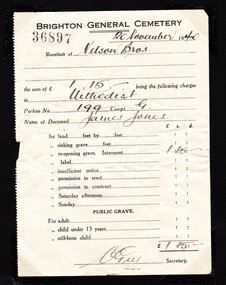
James Jones was the son of Philip Jones, a Chairmaker, and Ann Jones who settled in East Brighton after the sale of land c1852 in the area of the Henry Dendy Special Survey of 1841. Mary Ann Moore was the daughter of Thomas Moore, a Gardener, and Sarah Harris who also settled in Brighton c1852. James and Mary Ann Jones settled and raised their family in East Brighton now Bentleigh. Mr John Herron resided at 4 Vickery St Bentleigh until 1989. Sadly Martha Jones born 1888 died in 1890 and James Jones had to purchase a plot at Brighton General Cemetery for her burial. Baby Ethel May was interred in 1893 and then Mary Ann in 1903 and James in 1940. Their stillborn baby was buried in the Wesleyan public grave in 1900James Jones and Mary Ann Moore were born in Brighton c1857 and c 1859 into pioneer market gardener families in the area of the Dendy Special Survey of 1841. They married in 1883 and raised their family in East Brighton, now Bentleigh. Sadly infectious diseases took the lives of many infants throughout the Colony of Victoria due to the poor state of water supply and sewerage disposal and locally the swamps of the Elster Creek were a constant breeding ground. Martha Jones born 1888 died 1890 and was interred in the Brighton General Cemetery in a family plot, in the Wesleyan Section, purchased by her father James Jones. In 1893 another daughter Ethel May died and was buried in the family plot. A stillborn baby was interred in the public grave of Brighton General Cemetery in May1900. Mary Ann Jones died, at age 43years, and was interred in January 1903. Finally in November 1940 Mr James Jones was buried in the family grave. 2 original paper Receipts associated with the Burial of James Jones at Brighton General Cemetery 20th November 1940 by Nelson Bros. Funeral Directors of Williamstown1) 4202 Re the Funeral of the late Mr James Jones / 43 Douglas Parade Williamstown (Tel 34 & 43)/ 27/11/1940 / Received from Mr J P Jones./ by CHEQUE/ CASH the sum of Twenty eight pounds / ten shillings - pence/ WITH MANY THANKS / 7/563 / NELSON BROS./ £28:10:0 per N.Flack / THIS is our only recognised form of receipt / In full settlement / Stamped VICTORIA STAMP DUTY 3d 2) 36897 BRIGHTON GENERAL CEMETERY 20November 1940/ Received of Nelson Bros./ the sum of £1.15.- being the following charges/ in Methodist / Portion No. 199 Compt. G / Name of Deceased James Jones / for reopening grave £1.15.- / signed C Guy Secretarywesleyan church, brighton general cemetery, vaccination, pioneers, early settlers, typhoid, brighton, moorabbin, bentleigh, market gardeners, jones james, jones mary ann, jones martha, dendy henry, dendys special survey 1841, infectious diseases, water supply, elster creek, melbourne, orford g h, printers, southern cross office, “brighton leader” print, bay street brighton, jones ethel may, public grave brighton -
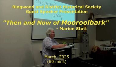 Ringwood and District Historical Society
Mixed media - Video, RDHS Meeting Presentation - "Then and Now of Mooroolbark" - Marion Stott OAM
Digitised video (3.68GB). Duration: 62 minutes. Recorded March, 2025 (Video is available for viewing at Ringwood & District Historical Society Archives by appointment)The Parish of Mooroolbark was surveyed in 1855, with a township originally called Brushy Creek standing where North Croydon is today. The name "Mooroolbark" was to be popularised with eventual European settlement in the late 19thy century. A rural hub developed around the train station, which opened in 1887 and offered rail access to Melbourne, with the Post Office opened shortly after in 1888. In this video presentation, Marion Stott, OAM, President and Founding Member of the Mooroolbark History Group, provides "Then and Now" details of all this and more. As well as activities in promoting local history, Marion is actively involved in local RSL, Traders group, and community events including Mooroolbark Red Earth Festival. For services to the community of Mooroolbark, Marion was awarded an OAM in 2020. -
 Orbost & District Historical Society
black and white photograph, 1916
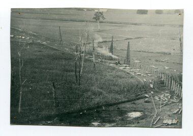
This photograph shows the pile drivers at work in the construction of the viaduct across the Snowy River flats. The Snowy River Floodplain Railway Bridges, two sequential and exceptionally long and low timber railway bridges on the Snowy River floodplain just west of Orbost, were built in 1916, and provided the original terminus point for the Bairnsdale-Orbost railway. The bridges are 770 metres and 183 metres long respectively. The shorter bridge is of uniformly 4.57 metre timber-beam construction, and has a sweeping curve in its deck. The longer bridge has a combination of 4.57 metre and 6.1 metrespans, and two 3.66 metre spans. The bridges are constructed from 'Southern Mahogany', Eucalyptus Botryoides, which grew along the coast east of Bairnsdale. The Snowy floodplain bridges were initially built in the context of an early twentieth-century interest in American-style 'Developmental Railways', designed to open remote areas to closer settlement, even if that meant running at a loss. The line was closed in August 1987. (information from Victorian Heritage Database)This item is associated with the history of the Orbost-Bairnsdale railway line and therefore reflects the role that the rail line played in the social and economic history of Orbost.A black / white photograph of the farming flats at Orbost during the construction of the East Gippsland railway.orbost-railway east-gippsland-railway viaduct-orbost transport railway -
 Orbost & District Historical Society
black and white photograph, late 19th century - early 20th century
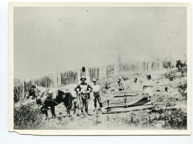
This photograph shows land clearing at Bendoc. From 1845 the Bendoc area was part of pastoral leases. In the 1850s alluvial gold was discovered in the Bendoc River. This was quickly exhausted, and a number of mines began successful reef operations. At the head of the river, the settlement of Clarkville clustered round several other mines. Many miners, including numbers of Chinese, sluiced the rivers. The population of the area was as high as 500 during this period. The township was surveyed in 1869 and the hotel built in 1870. This building was burnt down in the early 1900s and rebuilt. A school was also begun at this time. In the 1870s there was a decline in gold mining. Some miners selected land, which in many cases is still held by descendants. Dairying was common in the early days, supplying a butter factory at the New South Wales border, and a milk factory at Orbost in more recent times. Wheat was grown for the settlers' own use and ground at Bombala. Now beef cattle grazing is the main occupation. (info. from Victorian Places)This is a pictorial history associated with the early settlement of Bendoc in East Gippsland.A badly distorted black / white photograph of a horse drawn wagon, three men and two women clearing land.on back - "Clearing land at Bendoc"bendoc-land-clearing bendoc-early-settlement -
 Orbost & District Historical Society
black and white photograph, 1920s -1930s
The Cabbage Tree Creek township was originally established to support the booming timber industry of the mid 20th century. Five timber mills worked full time supporting the families that were drawn to the area's wealth of natural resources. The settlement of Cabbage Tree Creek is located on the Princes Highway, 27 km east of Orbost in East Gippsland. The first white settler arrived in the valley in 1887 cutting a dray track from Marlo to the south-west. Several families cleared the alluvial flats, growing maize, peas and beans and raising pigs, cattle and sheep. Later the farmers milked cows, sending cream to Orbost. In the late 1890s, small quantities of alluvial gold were found in the creek. A school commenced classes in 1913, but enrolment was small and at times the school operated part time with several other small schools in the area. The school building served as a hall for the district. From the 1920s the Cabbage Tree Hotel catered to drivers on the improved Princes Highway. (info. from Victorian Places)This is a pictorial record of Cabbage Tree, East Gippsland in the late 20th century. It shows a building that no longer exists.A small black / white photograph of a single storey timber building. On a sign below the roof is "Cabbage Tree Hotel". The hotel is surrounded by a wooden picket fence. A man and woman are standing on either side of a motor car parked on the roadway in front of the building.on back - on label - Cabbage Tree Hotelcabbage-tree-hotel -
 Warrnambool and District Historical Society Inc.
Original Document, Map: Agricultural area of Ballangeich 1865, 1865
George Eddington arrived in Australia in 1839 and named and established property in 1841 calling the property Ballangeich after a Pass near his home town of Stirling in Scotland. It is situated 151 miles west of Melbourne and to the south of Mortlake and was originally part of the Mortlake shire, which was proclaimed 26th Jan 1864. Nearest streams are the Hopkins Riverand Lyall and Drysdale creek running through good agricultural land. This map relates to the breaking up of large runs which the Victorian government enabled through selection acts of the 1860's. The previously larger runs which were mainly cattle and sheep based were now more open to closer settlement and a greater variety in farming.The lots range in size from approximately 50 acres to around 600 acres.Some areas are set aside for reserves. By 1886 the population of Ballangeich had grown to around 600 with an hotel, three state schools and a church.Tri weekly coaches ran to Colac, Warrnambool and Camperdown providing access to supplies mail and communication. This map is typical of many which were produced in the 1860's in Victoria during a significant period of Victoria's and Warrnambool district history.Rectangular light card paper with black text showing allotments of land The area is coloured in green with scale at bottom right cornerAt the top: Plan of the Agricultural area of Ballangeich 1865 At the bottom left: Prepared by the Board of Lands & Works in accordance with the Amending Land Act 1865 Lands & Survey Office Melbourne 13th April 1865. With signaturehistory of warrnambool, ballangeich, land surveys victoria 1865, lands act 1865 victoria, ballangeich map 1865 -
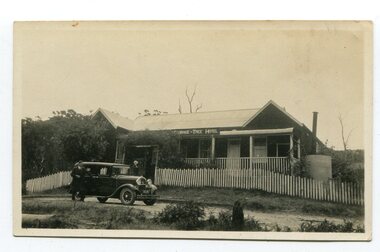
 Otway Districts Historical Society
Photograph, Brucker, Crowes after the 1919 fires, 1919
The 1919 bushfire was the worst the area suffered. The fire struck on Saturday afternoon on the 15th February. It destroyed the station at Lavers Hill and Crowes, departmental residences at Lavers Hill and Weeaproinah, the overhead bridges at Beech Forest and Wimba, and damaged the track at various points along the line so that two locomotives became temporarily marooned at Beech Forest.. By the following Tuesday a daily fire relief train had begun operation. By the following Sunday a special train loaded with army tents travelled through to Lavers Hill and deposited most of its consignment there because little remained of this sizeable settlement. An outsider would have had difficulty in picking the place. The letters of the Lavers Hill station nameboard had been burnt although the metal letters survived, and one of the local wags had rearranged them to read "LIARS HELL". By the 1920s water trains were being used to help fight fires, a simple NQR open wagon loaded with the standard 1500 litre square iron water tank.B/W. Crowes station sign, the remains of a chimney, galvanised iron sheet and a water tank, and two men gazing at the camera. Note in the background the clear felling of the timber.crowes; lavers hill; beech forest; weeaproinah; wimba; railways; bushfire; -
 Vision Australia
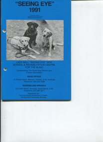
Administrative record - Text, "Seeing Eye" 1991 Lady Nell "Seeing Eye" Dog School & Rehabilitation Centre for the Blind, 1991
President's overview of the year including: discussion about the government investigation and those who gave negative testimony, withdrawal of Government's case and clearance of accusations, full disclosure of Terms of Settlement, inaccurate comparisons made with Kew facility, reflection on how investigations were conducted, resignation of Greg Cooper due to harassment by investigators, opening of a handicraft and rehabilitation centre in Annerley, article on Alf Kemmel and his involvement with the breeding program, mini profiles of some people with their dogs, 12 people graduated this year, request for more homes for breeding dogs, enlargement of day centre, and purchase of goodwill of St Leeor Nursing Home (freehold bought in 1985) to extend nursing home facilities to blind and visually impaired. Annual Report for Guide Dog Owners and Friends Association is also included with list of committee members, net surplus, auditor's report, biographical notes of Executive Director and Facts about Lady Nell Seeing Eye Dog School and Rehabilitation Centre.1 volume with text and illustrationsannual reports, lady nell seeing eye dog school, phyllis gration -
 Melton City Libraries
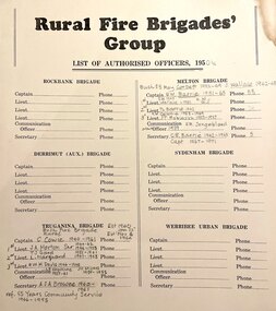
Document, Rural Fire Brigade's Group, c.1950
From the earliest days of settlement in the shire, residents demonstrated their willingness to band together in times of crisis and need. "Bushfires were always a terrifying prospect and since its establishment in 1935, the local fire brigade (later the Country Fire Authority) fought hard to protect the people, homes and animals of the shire. In 1966, the Mount Cottrell Fire Brigades Group was formed as a way of consolidating the smaller groups around Melton, Rockbank, Toolern Vale, Sydenham, Truganina and Werribee. Its headquarters were established at the home of Ernest ‘Bon’ and Edna Barrie in Ferris Road, Melton. Captain Bon Barrie was a member of the Melton Fire Brigade and elected group and communications officer of the new Mount Cottrell Brigades Group.22 Wendy Barrie, daughter of Edna and Bon, remembers the fire truck parked at their house and her mother operating the fire brigade’s radio. Growing up in the fire station headquarters, Wendy and her siblings learned how to use the radio too, in case of emergencies".Rural Fire Brigade's Group List of Authorised Officers including the captains and lieutenantsemergency services -
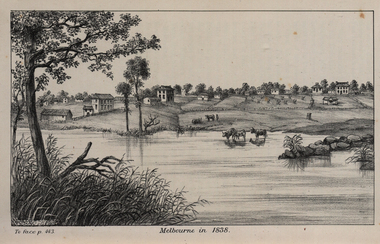 Federation University Historical Collection
Image, John Helder Wedge, Melbourne in 1838, 1938
The following information is from http://melbourneday.com.au/about.html, accessed 30 August 2016 Melbourne was founded on 30 August 1835 by settlers who sailed from Van Diemen’s Land (Tasmania) aboard the schooner Enterprize. They landed on the north bank of the Yarra River and established the first permanent settlement, close to where the Immigration Museum at the Old Customs House — on the corner of William and Flinders Streets — stands and the place today known as Enterprize Park. Melbourne Day Committee was established to help correct the record about the founding of Melbourne and celebrate its anniversaries. The settlers came from Launceston in search of sheep-grazing land. Land had become expensive and there had long been stories told by whalers and sealers working in Bass Strait of fertile land to the north. This was the southern part of the colony of New South Wales, which the Colonial Government did not want settled at that time. After the Henty family crossed Bass Strait and settled at Portland in 1834 others quickly followed. The north bank was chosen because a small waterfall, or rapids, stopped further progress up the river. The waterfall also separated the tidal movement, providing a vital supply of fresh water. The site had previously been noted by the colony of New South Wales' surveyor, Charles Grimes, in 1803. The north bank also offered more stable, suitable ground. The people of the Kulin nation are the traditional owners of the land that became Melbourne — including the Boonwurrung, Woiwurrung, Taungurung and Djadjawurrung people, who gathered in this place for ceremonies and cultural activities. The topsail schooner Enterprize you see today is a full-size replica of the one that brought the settlers and has become a symbol of Melbourne Day. Her keel was laid at Polly Woodside Maritime Museum in 1991, and the $2.5 million, 27m vessel was launched by Felicity Kennett on 30 August, 1997, at Hobsons Bay. The original ship was bought by John Pascoe Fawkner in April 1835 specifically to search for a suitable place for a settlement in the Port Phillip District. After helping establish Melbourne, the original Enterprize continued operating as a coastal trading vessel for a number of years. She eventually disappeared off the shipping register in 1847, having been wrecked on a sand bar in the Richmond River in northern NSW, with the loss of two lives. The replica is managed by the Enterprize Ship Trust, a not-for-profit organisation. The first settlers were those on board the Enterprize — her crew and passengers. They were John Lancey , master mariner and Fawkner’s representative; Enterprize's captain, Peter Hunter; George Evans, plasterer/builder; carpenters William Jackson and Robert Hay Marr; Evan Evans, George Evans’ servant; and Fawkner’s servants ploughman Charles Wise, general servant Thomas Morgan, blacksmith James Gilbert and his pregnant wife, Mary. And Mary's cat! Enterprize set sail on her historic voyage from Launceston on July 21, 1835, stopping at George Town in northern Tasmania where creditors detained Fawkner. He was therefore not part of the first trip to Melbourne. Enterprize then left on August 1 under the command of captain Hunter. The expedition was led by Lancey, Fawkner's delegate. The party first considered Western Port and the eastern side of Port Phillip for a place to settle, before deciding on the Yarra’s north bank — known today as Enterprize Park. On Sunday, August 30, they disembarked and began to erect shelter, build a store and clear land to grow food, thus starting the permanent European settlement of Melbourne.Image of the fledgling town of Melbourne on the banks of the Yarra River. melbourne, yarra river, john helder wedge -
 Marysville & District Historical Society
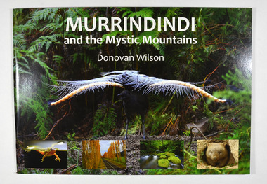
Book, Donovan Wilson, Murrindindi and the Mystic Mountains, Post 2009
A book of photographs of natural attractions, flora and fauna taken in and around the Murrindindi Shire.Paperback. Front cover has a large photograph of a lyrebird in full song. Along the lower edge of the front cover are four photographs; a Spotted March frog, the Gould Memorial Drive, a river and a wombat. Back cover has a photograph of the Cathedral Range at dawn.non-fictionA book of photographs of natural attractions, flora and fauna taken in and around the Murrindindi Shire.murrindindi, victoria, landmarks, flora, fauna, waterfalls, rivers, nature, natural attractions -
 Marysville & District Historical Society
Book, Donovan Wilson, Murrindindi and the Mystic Mountains, Post 2009
A book of photographs of natural attractions, flora and fauna taken in and around the Murrindindi Shire.Paperback. Front cover has a large photograph of a lyrebird in full song. Along the lower edge of the front cover are four photographs; a Spotted March frog, the Gould Memorial Drive, a river and a wombat. Back cover has a photograph of the Cathedral Range at dawn.non-fictionA book of photographs of natural attractions, flora and fauna taken in and around the Murrindindi Shire.murrindindi, victoria, landmarks, flora, fauna, waterfalls, rivers, nature, natural attractions -
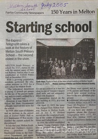 Melton City Libraries
Newspaper, Melton Schools-150 years in Melton, 2005
Melton South "The establishment of a settlement of Melton South was induced by the opening of the railway in 1884. This subsequently prompted a number of industries, initially sawmills, and in the early twentieth century, chaff mills. This development coincided with the Exford ‘Closer Settlement’ estate at the beginning of the new century, boosting local population and produce, and the development of the chaff industry which employed many people in the Melton area. (Around 1912 the government had brought out English migrants to settle the Exford estate.) By c.1912 the small Melton Railway Station settlement had a boarding house (probably for chaff or sawmill employees), store, a small church and a hall. The Melton Valley Golf Club originated near the railway station in 1927 (in 1931 it moved to the present Melton links). In 1910 the community had built the large timber ‘Victoria Hall’, which became the focus of community life for several generations. In August of that same year AR Robertson MP and D McDonald applied for the establishment of a school on land set aside for that purpose by the Closer Settlement Board, near the Melton Railway Station settlement. District Inspector McRae recommended that a school for classes up to Grade 3 be established as an adjunct to the Melton State School. And so SS3717, ‘Melton Railway School’, was established in the leased Victoria Hall on 1st December 1911. Thomas Lang, head master at Melton since 1896, was in charge of both schools. As a ‘prep’ school only, it was necessary that the older Melton Railway Station settlement students travel to Melton SS430 at Unitt Street. Since 1912 local residents had been petitioning for the establishment of a separate school at Melton Railway Station on the grounds that it would be better if all children from the one home could attend the same school, and that the Victoria Hall was unsuitable as a school building. As a result an area of 2 acres - Allotment 8, Parish of Djerriwarrh, Exford Estate - was reserved for a State School on 4th March 1914. However the Department wrote that a school would not be established there in the near future, as ‘there is no likelihood in sight that the Railway Station settlement will increase in importance’. Parents persisted with their petitions to the Education Department, claiming that the Victoria Hall was too large, had no fireplace, that teachers were unable to use the wall for teaching aids, and that, being less than 20 metres away from a chaff mill employing 30 men, was too noisy. The turning point came when in 1920 the Hall Committee decided to increase its rent for the hall. In 1920 Head Teacher Lang advised the Education Department to discontinue SS3717 as an adjunct. The District Inspector supported this recommendation, and the schools separated in 1923. In April of that year 41 children, comprising Grades 1-8, moved into an almost completed brick building on the present site. On the 6th July 1923 the official opening of the school took place; after a ceremonial journey from the Hall to the school, speeches were given by the Hon AR Robertson and the Chief Inspector of Education. Everyone then journeyed back to Victoria Hall for a ‘bountiful repast’. (These dates are at odds with the date of 5th March 1925 given in Blake as the date the children occupied the new SS3717 brick school building. ) A teacher’s residence had been purchased for ₤500 in 1923, and the school’s name was changed to ‘Melton South’ in the same year. Even though the older Melton South pupils would no longer have to travel to the Unitt Street school, an additional brick room was still required at the Melton SS430 in that same year. In 1961 a new room was added to the school. In 1972, at the beginning of Melton’s boom as a satellite town, the number of enrolments was 224. The school has since shared in the exponential growth of the town of Melton, and at the time of its jubilee celebration (1983), 524 pupils were enrolled. Victoria Hall, neglected and vandalised, was demolished in 1992. It had been handed back to the Council on condition that it be replaced by a new hall, with the same name, and was commemorated by a plaque. Apart from the 1923 brick school building, and the railway station, none of the principal early Melton South public sites survive. Few early residential sites remain. (Further research will establish whether the house on the corner of Station Street and the railway line was the original teacher’s residence.)" Melton State School "On 17th May 1858 a State subsidised, combined Denominational School was opened by HT Stokes, with an attendance of about 30 children. This school was conducted in the wooden Melton Combined Protestant Church, situated on ‘a creek flat’ thought to be on the north side of Sherwin Street between Pyke and Byran Streets. It is likely that the Church had been established by 1855 and that the first minister was the Rev. Hampshire, who lived in Cambridge House on the Exford Estate. Ministers of the Protestant denominations were invited to hold services there. As there was only one resident Minister in the town (Presbyterian Mr J Lambie), laymen of the various denominations often spoke on Sundays. In 1863 this building was declared a Common School with the number 430. One of its first and most prominent headmasters was John Corr, who served from 1860 to 1864. Most of Mr Corr’s children also became teachers, including Joseph Corr, at the Rockbank school, and J Reford Corr and WS Corr, headmasters and teachers at numerous prestigious private secondary schools around Australia. John Corr purchased land alongside the school and elsewhere in and near Melton, became secretary and treasurer of the new Cemetery Trust, and by July 1861 was deputy registrar of births, deaths and marriages. He walked three miles every Sunday to teach at the Weslyan Sunday School he had established. Despite good reports from the Education Department Inspector, and burgeoning enrolments, the local school committee recommended the dismissal of, firstly, his wife (from the work mistress position), and then him from the headmaster position. Corr saw his dismissal as an attempt to redirect state aid for education from the Combined Protestant school to the support of the Free Presbyterian Minister Rev James Lambie (by one account the owner of the land on which the Common School was erected), whose son-in-law James Scott subsequently assumed responsibility for the school. Rev Lambie failed in his efforts to keep the existing school, which the Education Department Inspector and the majority of Melton citizens regarded as badly situated and badly built. Following a conditional promise of state aid, local contributors in 1868-69 raised ₤72.10.6 towards the cost of an iron-roofed bluestone rubble building 43 ft x 12 ft. This was erected on a new site of 1.5 acres (the present site). The State contributed ₤120 to the new school, which opened in 1870. A very early (c.1874) photograph of the school shows its headmaster and work mistress / assistant teacher (probably James Scott and his wife Jessie) and its (very young) scholars. Similar photos show pupils in front of the school in c.1903, and 1933. In 1877 a second bluestone room costing ₤297 was added and further land acquired from the Agricultural Society (who only needed it two days a year) to enlarge the schoolground to 3 acres. In the early 1880s an underground tank augmented the school water supply and in 1919 a five-roomed wooden residence was added. During this period the school correspondents often compained that the walls of the bluestone buildings were damp, affecting the plaster. In 1923 a brick room 26 ft 6 in by 24 ft with a fireplace and four rooms facing south, was added, and a corridor built to link the three buildings. This served adequately for the next 40 years. The school bell probably dates to 1883. The school also has a memorial gate (1951) to World War One ex-students, and an honour board to the 64 ex-students who served in the First World War. The school roll fell to 42 in the early post war-years, but was boosted by an influx of migrants, mainly from the UK, from the late 1960s. This presaged the boom in Melton’s development, and the corresponding growth of the school, with timber and temporary classrooms added to the previous masonry ones. An endowment pine plantation established in 1930 augmented the school’s fundraising activities when it was harvested in 1968. Part of the site was planted with eucalyptus trees in 1959. Famous ex-students of the early twentieth century included Hector Fraser (internationally successful shooter) and cyclist Sir Hubert Opperman". The Express Telegraph articles about the history of Melton South and Melton State Schoolseducation -
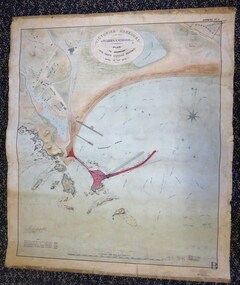 Warrnambool and District Historical Society Inc.
Map - Warrnambool Port 1879, 1879
The port facilities in Warrnambool Bay were in constant use from the first years of Warrnambool’s settlement but there were also difficulties for the shipping trade – a small and unsafe anchorage, the lack of loading facilities and little natural protection from the southerly gales. From the 1870s on there was local agitation for some sort of Breakwater to be built and an Andrew Kerr design was approved by the Warrnambool Council but no funds were made available from the Victorian Government. Throughout the 1870s the building of a Breakwater was a major political issue in the district with preliminary work being funded and started in 1874. In 1879 the Government agreed to a further inspection of the area and an official report. Sir John Coode (1816-1892) was commissioned to make this report. He had come to Australia in 1872 to advise on harbour construction. Coode recommended a 1800 feet long Breakwater and wharf connected to the shore and it was this proposal that the plan described herein and drawn up in 1879 was to accompany. The original plan was eventually modified because of the cost and a Breakwater was completed in 1890 under the direction of the engineer, Arthur Dudley Dobson, with extensions early in the 20th century. This plan is of great interest as it shows in simple graphic form the original plans proposed by Sir John Coode for the Warrnambool Breakwater. It is therefore of great historical importance. The Breakwater was not the maritime success that it was hoped it would be but it is today a significant feature of our foreshore. This is a Plan drawn up in 1879 by Victorian Harbours to accompany Sir John Coode’s Report on the proposed Warrnambool Breakwater. The chart detail is hand-drawn and hand-tinted on canvas with the names of places, geographical and marine features and local points of interest added in print. The edges of the chart are rubbed and the chart is somewhat faded and dirty but the main colours of red, green and brown are still clearly discernible. The title of the plan is printed in an oval inset at the top of the chart. The plan shows two possible Breakwater designs, one from the Borough Surveyor (Andrew Kerr?) and one from Sir John Coode.Victorian Harbours Warrnambool Plan to accompany Sir John Coode’s report Dated 28th Feby 1879 warrnambool breakwater, andrew kerr, sir john coode, arthur dudley dobson, warrnambool, warrnambool harbour, warrnambool history, warrnambool beach