Showing 31831 items
matching south
-
 Mission to Seafarers Victoria
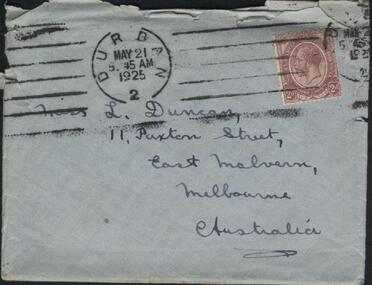
Letter - Correspondence, Letter to Lillie from Joe, 19 May 1925
The "letters to Lillie" show the international nature of the Mission to Seafarers. They are an important display of the handwriting style of the time, revealing courting attempts and give us an insight into life in 1925.Lillie Duncan was a member of the Harbour Lights Guild and this letter forms part of a collection of letters sent to her by different seafarers.Letter addressed to Miss L Duncan, 11 Paxton St, East Malvern, Melbourne, Australia from Howard in four parts: Part 1.1 (0008.1) Envelope Part 1.2 (0008.2) First page of letter Part 1.3 (0008.3) Second page of letter Part 1.4 (0008.4) Third page of letter The envelope is blue grey in colour whilst the pages are creamy yellow in colour. Page 1 of the letter begins with the salutation "My dear Lillie, here comes the promised letter...". Page 2 of the letter begins with "...in her birthday book". Page 3 of the letter concludes with "...yours Joe".The envelope is torn across the top for access to its contents. It has two stamps, a circular one in black ink towards the top left of the envelope reading "Durban, 2, May 21, 5.45AM, 1925", and a rectangular one coloured red and white reading "Union of South Africa, Postage, 2d" on the left-hand side of the circle and the right-hand side circle seems to say the same in South African perhaps. It is obscured by 6 large ink lines covering the top portion of the envelope from left to right. Within the circle is a mans head showing his left side profile. He has a beard and short hair. On the right side of the red and white stamp there is a second ink stamp that is also obscured but seems to be the same ink stamp as the first. letter, joe, handwriting, 1925, lillie duncan, lhlg, durban, lillian duncan, ladies harbour lights guild, mission to seafarers, mission to seamen, seamen's mission, east malvern, my little melbourne girl -
 Eltham District Historical Society Inc
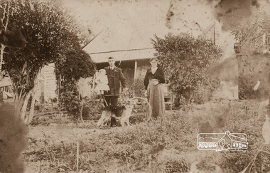
Photograph, Mrs Henry Hill (nee Georgina Reynolds of Research) and others outside the old Hill residence in Bridge Street, Eltham
Early settlers of Eltham Black and white photograph postcardMrs Henry Hill (nee Georgina Reynolds of Research), mother of John Ernest Hill. Identity of others not known to Mrs A.E. Hill , who states 'photo was taken outside the old Hill residence, Bridge St, (south side between Susan and Bolton Streets). Demolished many years ago - 26.7.65 Also stamped - Shire of Elthamhouses, mrs henry hill, bridge street, georgina hill (nee reynolds), hill family, hill family home, john ernest hill -
 Victoria Police Museum
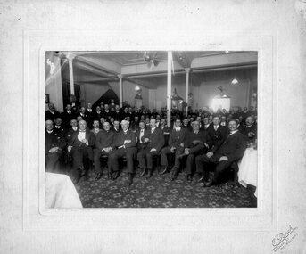
Photograph (Victoria Police), Police Officers group photo on dinner event, 21 November 1912
Black and white photograph mounted on bege frame. Depicts about 100 men sitting on large room with printed carpet. They all wear suits and are posing for photograph, men sitting on the front have big mustaches and are smoking cigars. Some of them wear Freemansonry waistcoast chain.E. Brick // 48 Queen St // Melbourne (printed on front of frame in bottom right) Smoke night given at Sargeants Cafe // to New South Wales Police band on Thursday evening // 21 of November 1912 (handwritten on top centre of the back of frame) 84 68 (top left) AP 95 (top right) P 92 (bottom left) victoria police museum, police officers, police academy, police force, freemasonry, masons, free masons, sargeants cafe, brick, e, new south wales police -
 Ringwood and District Historical Society
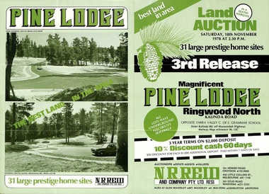
Flyer, Land Auction Sale Brochure, Pine Lodge, Ringwood North, Victoria - 3rd Release 1978
Refer also to Reg. No. 5171 for Pine Lodge Land Auction previous release, 1977.Green tri-fold advertisement for auction of home sites, with map of subdivision, photographs, and summary of local features and services for Pine Lodge, Kalinda Road, Ringwood North - 3rd release - Auction date, Saturday, 18th November, 1978, at 2:30pm.Subdivision plan includes Mundara Drive, Bidston Court, Parkgate Drive, Frodsham Road, and Bebington Close. (Agent) N.R. Reid & Co. Pty. Ltd., 10A Hewish Road, Croydon (Phone) 725 0999, 450 Little Collins Street, Melbourne (Phone) 67 1746, and 207 Stud Road, Wantirna South (Phone) 221 2222. -
 Glenelg Shire Council Cultural Collection
Photograph - Photograph - Cape Grant Quarry, Quarry, Cape Grant, 01/11/1956
Port of Portland Authority ArchivesFront: Back- Border ruled around in pencil. Cape Grant Quarry 1/11/56 'View to south east showing excavtor on limestone level, quarry master on 70ft level and box blast result on 40ft level in foreground. Note rock fave obscured by over burden material' - Pencil '5 x 3/4 approx' - pencilport of portland archives -
 Ringwood and District Historical Society
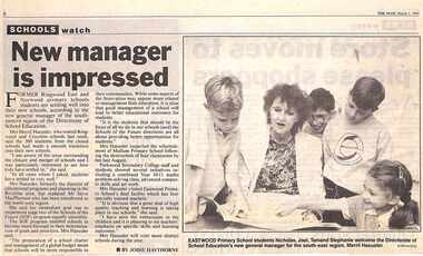
Newspaper, Scrapbook Clipping, Library Collection, Ringwood, Victoria, `
``Newspaper clipping from "The Mail", 1-03-1994 P1. SCHOOLS watch. New Manager is impressed. By Jodie Hawthorne Former Ringwood East and Norwood primary school students are settling well into their new schools, according to the new general manager of the south eastern region of the Directorate of School Education. Mrs Merril Haeusler, who toured Ringwood and Croydon last week, said the 300 students from the closed schools had made a smooth transition into their new schools.` -
![Scene in the Melbourne Botanical Gardens / [by] Nicholas Caire, circa 1876](/media/collectors/550653872162f11fb04854aa/items/577b5a2dd0cdd10948d09d9a/item-media/577b5a96d0cdd10948d0d84a/item-fit-380x285.jpg) Kew Historical Society Inc
Kew Historical Society IncPhotograph, Anglo-Australasian Photographic Company, Scene in the Melbourne Botanical Gardens, c. 1876
Nicholas Caire was born on Guernsey in the Channel Islands in 1837. He arrived in Adelaide with his parents in about 1860. In 1867, following photographic journeys in Gippsland, he opened a studio in Adelaide. From 1870 to 1876 he lived and worked in Talbot in Central Victoria. In 1876 he purchased T. F. Chuck's studios in the Royal Arcade Melbourne. In 1885, following the introduction of dry plate photography, he began a series of landscape series, which were commercially successful. As a photographer, he travelled extensively through Victoria, photographing places few of his contemporaries had previously seen. He died in 1918. Reference: Jack Cato, 'Caire, Nicholas John (1837–1918)', Australian Dictionary of Biography.An original, rare photograph from the series 'Views of Victoria: General Series' by the photographer, Nicholas Caire (1837-1918). The series of 60 photographs that comprise the series was issued c. 1876 and reinforced a neo-Romantic view of the Australian landscape to which a growing nationalist movement would respond. Nicholas Caire was active as a photographer in Australia from 1858 until his death in 1918. His vision of the Australian bush and pioneer life had a counterpart in the works of Henry Lawson and other nationalist poets, authors and painters.Views of Victoria (General Series) No.30 / ‘Scene in the Melbourne Botanical Gardens’ / Albumen silver photograph mounted on boardOn Reverse: ‘The Scene of the present illustration is taken from the Hill on the South Yarra side of the Gardens, shewing in the distance the Government Domain. In the centre of the picture a portion of the Lake may be seen. This Lake is of considerable extent, and being surrounded by hills, the slopes of which contain many beautiful Fern Groves and Vistas of the densest foliage, adds greatly to the beauty and picturesqueness of the surrounding scenery.’nicholas caire (1837-1918), australia - landscape photography -
 Mission to Seafarers Victoria
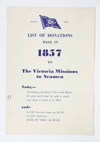
Pamphlet, List of Donations made in 1857 to the Victoria Missions to Seamen, 1957
The inside pages of this pamphlet list the many donors and subscribers who initially supported the Victorian Mission to Seamen whose first chapel was based on a floating Hulk named the Emily. The most generous 1857 donors at 20 guineas Dove and Oswald, ship owners, (also the name of the Heritage floating dock at Williamstown). The point of this pamphlet published in 1957 appears to be a reminder of longstanding support and as part of an appeal to new donors to assist with increased costs. It also compairs the donations betwwen 1857, 50 years later in 1907, and in 1957 the year of Centenary. It may well have been designed to hand out at screening of the short documentary produced by Cinesound circa 1956/57 and 'starring' Padre Oliver visiting ships and footage of the Mission interiors at both 717 Flinders st and the Deco 1936 building at Port Melbourne.The listing of donors is of some historical significance showing the range and names and is a useful reference for further research re significant figures of Melbourne and Victoria in the original establishment of the Mission by the Bethel Union.single fold paper pamphlet with blue printed text with flag of the Missions to Seamen at top of page.List of Donations / made in 1857 to the / Victoria Missions / to Seamen / Today - According to the bank of New South Wales / the price paid today for gold is nearly four times as much as in 1857. / and- / In 1907 the basic wage was 2 pounds 2/- ( 2 Guineas) / In 1957, 12 - 15 pounds/ Over six times as much. Inside the pamphlet alphabetical list of donorsdonor names, 1857, centenary, fundraising, mission to seafarers, seamen's mission, donations, 1957, 1907, currency conversion -
Linton Mechanics Institute and Free Library Collection
Book - Novel, West, Tom, Six-gun showdown, 1948
Western adventure story158 p. : blue cover, section of original dust jacket pasted to front, image depicts a man in a sombrero engaged in a gunfight with a man in a stetson hat. Plot summary cut from dust jacket pasted inside front cover.fictionWestern adventure storyfiction, westerns, tom west -
 Bendigo Military Museum
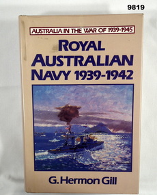
Book - RAN, WW2, G Hermon Gill, 'ROYAL AUSTRALIAN NAVY 1939-1942", First Published 1957. This edition 1985
From Dust cover - "AUSTRALIA IN THE WAR OF 1939-1945/ ROYAL/ AUSTRALIAN/ NAVY 1939-1942". Part of the "William (Bill) THOMASON" collection. Refer Cat. No. 4136P for more items.Hardcover book with dust cover. Cover - cardboard, dark blue colour buckram with gold colour print on spine. Dust cover - paper, dark blue and red colour print on front and spine with beige colour background. Illustrated front, in colour of an oil painting depicting "HMAS SYDNEY" in action. Flaps, front and back have blue and black colour print information. 689 pages- cut , plain, off white colour paper. Illustrated - black and white photographs and maps. End paper - front and back - owner library stamps, three at front, one at back.Library Stamps - black ink. Front; "Base Library/ Base Squadron/ RAAF Base/ EDINBURGH SA 5111/ CANCELLED" "DEFENCE REGIONAL LIBRARY/ ADELAIDE/ SOUTH AUSTRALIA" (Also at back). "DEFENCE INFORMATION SERVICE/ CALL NO. / ACC. NO./ ?RV. NO./ CAT NO." with handwritten - grey lead pencil - information "940-545994/AUS" "090229K" Black ink stamp "358930" "publications, books, ran, 1939-1945, william (bill) thomason collection -
 The Beechworth Burke Museum
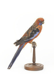
Animal specimen - Crimson Rosella, Trustees of the Australian Museum, 1860-1880
This specimen is part of a collection of almost 200 animal specimens that were originally acquired as skins from various institutions across Australia, including the Australian Museum in Sydney and the National Museum of Victoria (known as Museums Victoria since 1983), as well as individuals such as amateur anthropologist Reynell Eveleigh Johns between 1860-1880. These skins were then mounted by members of the Burke Museum Committee and put-on display in the formal space of the Museum’s original exhibition hall where they continue to be on display. This display of taxidermy mounts initially served to instruct visitors to the Burke Museum of the natural world around them, today it serves as an insight into the collecting habits of the 19th century. The Crimson Rosella is relatively easy to see as it forages on the ground or among the leaves of eucalypts, with its spectacular combination of deep-crimson, royal-blue and black plumage. However, not all Crimson Rosellas look the same. Along the Murray River, Crimson Rosellas aren’t crimson at all — they are yellow, black and blue, with the yellow feathering replacing the crimson plumage. In southern South Australia they differ again, being roughly intermediate between crimson and yellow, with varying amounts of red and yellow in their plumage. Research featured in the 'State of Australia's Birds 2015' headline and regional reports suggest that the Crimson Rosella may be declining in the East Coast. There are several populations of the Crimson Rosella. Red (crimson) birds occur in northern Queensland, in southern Queensland to south-eastern South Australia and on Kangaroo Island. Orange birds are restricted to the Flinders Ranges region of South Australia, while yellow ones are found along the Murray, Murrumbidgee and neighbouring rivers (where yellow birds meet red birds they hybridise, producing orange offspring). Red birds have been introduced to Norfolk Island and New Zealand.This specimen is part of a significant and rare taxidermy mount collection in the Burke Museum. This collection is scientifically and culturally important for reminding us of how science continues to shape our understanding of the modern world. They demonstrate a capacity to hold evidence of how Australia’s fauna history existed in the past and are potentially important for future environmental research. This collection continues to be on display in the Museum and has become a key part to interpreting the collecting habits of the 19th century.There are several colour forms of the Crimson Rosella. The form it is named for has mostly crimson (red) plumage and bright blue cheeks. The feathers of the back and wing coverts are black broadly edged with red. The flight feathers of the wings have broad blue edges and the tail is blue above and pale blue below and on the outer feathers. This particular specimen has lost some feathers in its plumage and its colour is not as bright as that of a live specimen.Label: 77a / Pennant's Parakeet / See catalogue, page 22taxidermy, crimson rosella, bird, australian bird, rosella, crimson -
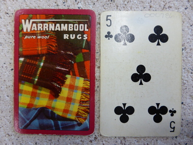 Warrnambool and District Historical Society Inc.
Card, Playing Cards x 2, 20th century
These cards, presumably part of a pack of cards (or two packs) are an advertising tool for Warrnambool rugs made by the Warrnambool Woollen Mill. The Warrnambool Woollen Mill in South Warrnambool was opened in 1910 with John Bennett the first manager. It produced woollen blankets and rugs and woollen products during the war years for military purposes. It closed in 2000.These cards are of interest as an advertising tool for the Warrnambool Woollen Mill which was a major industry in Warrnambool for 90 years. It shows the advertising techniques used by businesses in the 20th century.These are two regulation-size playing cards, both showing the five of clubs, with a colour advertisement for Warrnambool Rugs on the back. The advertisement features an assortment of Warrnambool woollen rugs. On back of cards – ‘Warrnambool Rugs, pure wool’warrnambool woollen mill, cards -
Eltham District Historical Society Inc
Document - Folder, Murphy, James and descendants
James Murphy was a mining surveyor involved with the Caledonia diggings. Contents Note from Ray Blake, 26 April 2000: Ms Murphy said her people had traditionally owned all of inner Melbourne, north to the Great Divide, West to Werribee River, East to Mt Baw Baw, South to Mordialloc Creek.Newspaper clippings, A4 photocopies, etcjames murphy -
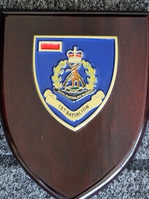 Lara RSL Sub Branch
Plaque, Late 20th Century
1st Battalion Australia is an Infantry Battalion of the Australian Army. The 1st Battalion can be traced back to 1854 as a unit of Volunteer Rifles raised in New South Wales. The Battalion was active during periods 1914-1919, 1921-1930 and 1957-1971. The Battalion is still in existence as the 1st/19th Battalion Royal NSW Regiment.The Plaque is an original.Wooden Plaque, tri shadark brown background, ?metal blue plaque with the RAR Badge, 1st Battalion underneath the badge, Red US Badge for Commendation.RAR, !st Battalion -
 Greensborough Historical Society
Book, Nillumbik Shire Council, 1997 Community Guide Nillumbik, 1997_
Guide to services provided by Nillumbik Shire Council. Nillumbik Shire is located 25 kilometres north-east of Melbourne and the southern boundary is the Yarra River. The south of Nillumbik is predominantly urban, with commercial centres at Eltham and Diamond Creek. The north of the municipality includes significant natural features like Kinglake National Park and Sugarloaf ReservoirAnnual guide to services in Nillumbik. 64 pages. Cover is pale yellow with colour drawings. nillumbik shire council, handbooks -
 Greensborough Historical Society
Book, Nillumbik Shire Council, 1998 Community Guide Nillumbik, 1998_
Guide to services provided by Nillumbik Shire Council. Nillumbik Shire is located 25 kilometres north-east of Melbourne and the southern boundary is the Yarra River. The south of Nillumbik is predominantly urban, with commercial centres at Eltham and Diamond Creek. The north of the municipality includes significant natural features like Kinglake National Park and Sugarloaf ReservoirAnnual guide to services in Nillumbik 72 pages. Cover has white background and some 3-D artwork.nillumbik shire council, handbooks -
 Greensborough Historical Society
Book, Nillumbik Shire Council, 1999 Community Guide Nillumbik, 1999_
Guide to services provided by Nillumbik Shire Council. Nillumbik Shire is located 25 kilometres north-east of Melbourne and the southern boundary is the Yarra River. The south of Nillumbik is predominantly urban, with commercial centres at Eltham and Diamond Creek. The north of the municipality includes significant natural features like Kinglake National Park and Sugarloaf ReservoirAnnual guide to services in Nillumbik76 pages, illus. Cover has photographs of local people and title in white on orange background.nillumbik shire council, handbooks -
 Greensborough Historical Society
Book, Nillumbik Shire Council, Nillumbik Community Guide 2000/2001, 2000-2001
Guide to services provided by Nillumbik Shire Council. Nillumbik Shire is located 25 kilometres north-east of Melbourne and the southern boundary is the Yarra River. The south of Nillumbik is predominantly urban, with commercial centres at Eltham and Diamond Creek. The north of the municipality includes significant natural features like Kinglake National Park and Sugarloaf ReservoirAnnual guide to services in Nillumbik76 pages, black and white illustrations. Cover has a collage of local children with title in white on mid-blue background.nillumbik shire council, handbooks -
 Greensborough Historical Society
Photograph - Digital image, Marilyn Smith et al, Janefield Precinct: gumtree, 27/11/2014
Janefield Precinct: gum tree. The remains of this site are between Greensborough and Janefield. A RAAF Hygiene Training Camp was located on the Plenty River, just south of the Janefield community. It was in use from 1944 to 1946. The Camp was constructed from salvaged materials. Instruction included building and maintenance of grease traps, latrines, elementary plumbing and carpentry.Early remains of a WW2 training campDigital colour photograph.janefield -
 Greensborough Historical Society
Photograph - Digital image, Marilyn Smith et al, Janefield Precinct: hawthorn trees, 27/11/2014
Janefield Precinct: hawthorn trees. The remains of this site are between Greensborough and Janefield. A RAAF Hygiene Training Camp was located on the Plenty River, just south of the Janefield community. It was in use from 1944 to 1946. The Camp was constructed from salvaged materials. Instruction included building and maintenance of grease traps, latrines, elementary plumbing and carpentry.Early remains of a WW2 training campDigital colour photograph.janefield, raaf hygiene training camp janefield -
 Greensborough Historical Society
Photograph - Digital image, Marilyn Smith et al, Janefield Precinct: more pondering - Janefield view, 27/11/2014
More pondering - Janefield view. The remains of this site are between Greensborough and Janefield. A RAAF Hygiene Training Camp was located on the Plenty River, just south of the Janefield community. It was in use from 1944 to 1946. The Camp was constructed from salvaged materials. Instruction included building and maintenance of grease traps, latrines, elementary plumbing and carpentry.Early remains of a WW2 training camp Digital colour photograph. -
 Greensborough Historical Society
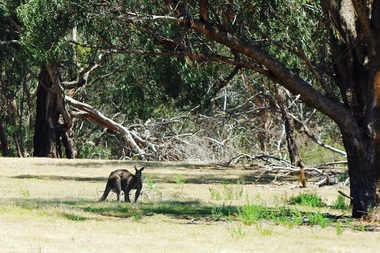
Photograph - Digital image, Marilyn Smith et al, Janefield Precinct: Lone kangaroo, 27/11/2014
Janefield Precinct: Lone kangaroo. The remains of this site are between Greensborough and Janefield. A RAAF Hygiene Training Camp was located on the Plenty River, just south of the Janefield community. It was in use from 1944 to 1946. The Camp was constructed from salvaged materials. Instruction included building and maintenance of grease traps, latrines, elementary plumbing and carpentry.Early remains of a WW2 training camp Digital colour photograph.raaf hygiene training camp janefield -
 Greensborough Historical Society
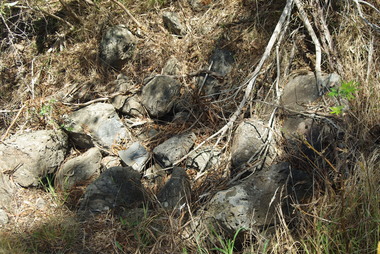
Photograph - Digital image, Marilyn Smith et al, Janefield Precinct: Basalt remains, 27/11/2014
Janefield Precinct: Basalt remains. The remains of this site are between Greensborough and Janefield. A RAAF Hygiene Training Camp was located on the Plenty River, just south of the Janefield community. It was in use from 1944 to 1946. The Camp was constructed from salvaged materials. Instruction included building and maintenance of grease traps, latrines, elementary plumbing and carpentry.Early remains of a WW2 training camp Digital colour photograph. -
 Greensborough Historical Society
Photograph - Digital image, Marilyn Smith et al, Janefield Precinct: Basalt Rubble, 27/11/2014
Janefield Precinct: Basalt rubble. The remains of this site are between Greensborough and Janefield. A RAAF Hygiene Training Camp was located on the Plenty River, just south of the Janefield community. It was in use from 1944 to 1946. The Camp was constructed from salvaged materials. Instruction included building and maintenance of grease traps, latrines, elementary plumbing and carpentry.Early remains of a WW2 training camp Digital colour photograph. -
 Greensborough Historical Society
Photograph - Digital image, Marilyn Smith et al, Janefield Precinct: Grease traps, 27/11/2014
Janefield Precinct: Grease traps. The remains of this site are between Greensborough and Janefield. A RAAF Hygiene Training Camp was located on the Plenty River, just south of the Janefield community. It was in use from 1944 to 1946. The Camp was constructed from salvaged materials. Instruction included building and maintenance of grease traps, latrines, elementary plumbing and carpentry.Early remains of a WW2 training camp Five digital colour photographs. -
 Greensborough Historical Society
Photograph - Digital image, Marilyn Smith et al, Janefield Precinct: Ruined slabs, 27/11/2014
Janefield Precinct: Ruined slabs. The remains of this site are between Greensborough and Janefield. A RAAF Hygiene Training Camp was located on the Plenty River, just south of the Janefield community. It was in use from 1944 to 1946. The Camp was constructed from salvaged materials. Instruction included building and maintenance of grease traps, latrines, elementary plumbing and carpentry.Early remains of a WW2 training camp Digital colour photograph. -
 Greensborough Historical Society
Photograph - Digital image, Marilyn Smith et al, Janefield Precinct: Chimney remains, 27/11/2014
Janefield Precinct: Chimney remains. The remains of this site are between Greensborough and Janefield. A RAAF Hygiene Training Camp was located on the Plenty River, just south of the Janefield community. It was in use from 1944 to 1946. The Camp was constructed from salvaged materials. Instruction included building and maintenance of grease traps, latrines, elementary plumbing and carpentry.Early remains of a WW2 training camp Digital colour photograph.janefield -
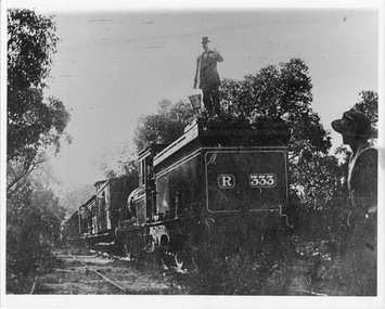 Halls Gap & Grampians Historical Society
Photograph - B/W, C 1882
Occasional picnic trains took large groups of visitors to the base of the mountain range & sometimes as far as the quarry. Other journeys terminated at Fyans Creek station on the south side of Mt Dryden. Most trips were Sunday School & Church outings, some on the annual Good Friday picnic. Spring was also a popular timePhoto shows train at siding. Man standing on engine roof with bucket in hand; woman in right hand corner of photo looking on; passenger looking out of open doorway. R333 written on back of engine car. Engine turned back to fronttransport, trains -
 Eltham District Historical Society Inc
Book, Melway Publishing, Melway Greater Melbourne street directory : including Geelong, Phillip Island, Healesville, Bellarine & Mornington Peninsulas, 2002
Edition 29. Coloured detailed maps accessed by a street or location index. Cover: 20 additional pages of new maps, extended coverage of Bellarine Peninsula, further coverage of Werribee South, Public Transport Information, latest official suburb boundaries, CBD "hook turn" intersections map, over 1200 new streets, 1 atlas (24, 886 p.) : col. maps ; ISSN 03113957streets, roads, melbourne, maps, melway -
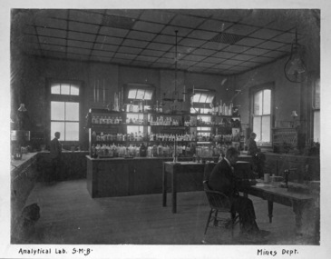 Federation University Historical Collection
Photograph - Photograph (Black & White), Ballarat School of Mines Analytical Laboratory, c1900
Around 1900 the Ballarat School of Mines had an international reputation. it is thought that that this photograph was originally taken by the New South Wales Mines Department during a visit to Victoria. This photograph was reproduced in the Ballarat School of Mines Annual Report 1900 This image is now (2012) used as Founders' Room in the Ballarat School of Mines Administration Building. Black and white photograph on green mountboard. It shows three men in a Ballarat School of Mines laboratory surrounded by chemicals and scientific equipment.Written on lower mount "Analytical Lab. S.M.B. Mines Deptmining, ballarat school of mines, chemistry, laboratory, scientific objects, scientific instruments, analytical laboratory, administration building, a building, founders room