Showing 2276 items
matching 1920s
-
 Orbost & District Historical Society
black and white photographs, Howard D. Bulmer, first half 20th century
This bridge was built in the 1920s as a road and rail bridge, and was partly washed away by flood waters in 1934. After the end of the first World War the Victorian Railways considered an extension of the railhead across the river at Orbost, and in 1922 a new timber and steel girder structure, a joint Country Roads Board — Victorian Railways venture, was built and completed at a cost of £41,000 (the steel girders came from the Flinders Street viaduct reconstruction). Subsequently it was decided not to take the railway across the river, and the bridge has only been used by road traffic. This is a pictorial record of an early bridge across the Snowy River at Orbost.A large black / white photograph of the Orbost Snowy River bridge. There is a large copy as well as a postcard copy in sepia.on front - Snowy River Bridge Orbost H.D. Bulmer - photo - Lake Tyers.snowy-river-bridge-orbost -
 Warrnambool and District Historical Society Inc.
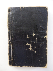
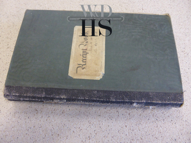
Book, Gospel Hymns, Late 19th century
This book of hymns belonged either to the Warrnambool Chinese Church or to its catechist, Thomas Wong Cheong. The Chinese Church in Ryot Street, Warrnambool was established under the aegis of the Presbyterian Church in the 1890s and continued on until the late 1920s when the local Chinese community numbers had dwindled. Thomas Wong Cheong was appointed in 1892 as a catechist to the Chinese community in Warrnambool and district by the Foreign Missions Committee of the General Assembly of the Presbyterian Church of Victoria. He and his wife worked tirelessly on the district until his death in 1923. This book is of great interest as an example of the hymn books used in the Chinese Church in Warrnambool at the end of the 19th and the beginning of the 20th centuries. The Chinese Church in Ryot Street and its catechist Thomas Wong Cheong are of considerable historical interest. This is a soft cover book with a black cover. The spine has become completely detached and has been re-stitched with thread. The pages have ruled black lines with the text printed in Chinese characters within these lines. What is probably the front page has a yellow-coloured page with large Chinese characters. The back page has two inserted pages containing the English index to the gospel hymns, Parts 1 to 4. The material on the cover is torn and frayed at the edges. The pages are dog-eared. chinese church warrnambool, thomas wong cheong, history of warrnambool -
 Warrnambool and District Historical Society Inc.
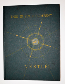
Book, Nestle and Anglo-Swiss Holding Company, This Is Your Company - Nestle's, 1946
The history of the first 80 years of the Nestle's CompanyThis is a book of 122 pages. It has a dark green cover with a gold compass pattern and gold printing on the front cover and spine. The pages contain printed text, maps, diagrams, graphs, colour illustrations and sepia -toned photographs.non-fictionThe history of the first 80 years of the Nestle's Companydennington nestle's factory, dennington, warrnambool, milk production, milo, nescafe production, warrnambool manufacturing -
 Warrnambool and District Historical Society Inc.
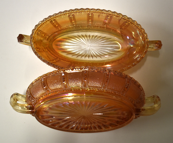
Decorative object - Oval Carnival Ware Dishes, c. 1940
These two orange-coloured dishes are made of pressed glass to which an iridiscent surface shimmer has been added by the application of metallic salts. They are examples of Carnival Ware and the orange colour is known in the trade world as 'marigold'. Carnival Ware was first produced in 1908 as a relatively cheap version of decorative glassware in U.S.A. and this country was the main producer up to the 1940s, with the 1920s being the decade when it was most popular. Carnival Ware was also produced in other countries including Australia and the United Kingdom and is a collectable item today. These two dishes have no known local provenance and are retained as examples of vintage household items serving both a utilitarian and a decorative purpose..1 An oval shaped shallow glass dish with pressed patterns and handles at either end. The item is orange-coloured. .2 as abovecarnival ware, orange glass dishes, vintage decorative items -
 Warrnambool and District Historical Society Inc.
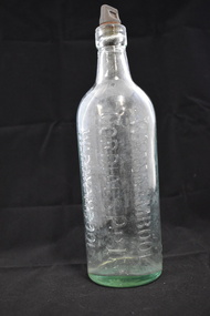
Bottle, Warrnambool Cordial, Mid 20th century
This bottle came from the Warrnambool business of Warrnambool Cordials Pty Ltd. This business started when Joseph Lescai, a fruiterer in Fairy Street, Warrnambool in the 1920s, began making cordials and soft drinks. Soon this became his core business until it was taken over by a group of Warrnambool businessmen. The business, known as Warrnambool Cordials, was then bought in the 1930s by a Warrnambool garage proprietor, Thomas Hill. Charles and Frederick Flett then purchased the business in the early 1940s and in the 1960s the business was taken over by Thomas McKenzie. The business lasted until the 1980s. This bottle is of interest as an example of the products of the Warrnambool business of Warrnambool Cordials Pty Ltd. Cordial manufacturing was an important business in Warrnambool for over 100 years and Warrnambool Cordials Pty Ltd was a prominent business for many years. This is a green-tinged glass bottle with a rounded base and a rounded body tapering to a short rounded neck and moulded glass top with an opening. It has a screw top composite material stopper with the name of the lemonade maker on the top. Information on the lemonade maker is also impressed into the glass on the side of the bottle. ‘Warrnambool Cordials’ Warrnambool Cordials Pty. Ltd. Warrnambool’ ‘Lemonade’ ‘This bottle is the property of the Warrnambool Cordials Pty. Ltd. Warrnambool’ warrnambool cordials pty ltd, cordial manufacturing in warrnambool, history of warrnambool -
 Warrnambool and District Historical Society Inc.
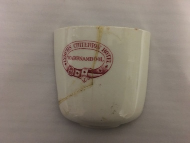
Household, Cup Fragment
This fragment is a piece of a cup that came from the Criterion Hotel in Warrnambool. This hotel, on the western side of Kepler Street near Lava Street, Warrnambool, was opened in 1872 with John Tate as the first licensee. Two notable families associated with the Criterion Hotel were the Humm family, (late 19th and early 20th centuries) and the McGennan family ( from the late 1920s on) The name on the fragment is that of Theresa Lynch who was the licensee of the hotel from 1919 to 1926 and the owner for most of that time. The hotel was closed in 2008 and, following a fire, the building was demolished in 2013.This fragment is of interest as it is one of the few items we have that date from the time of Theresa Lynch and the Criterion Hotel.This is a curved piece, one half of a white china cup. The fragment has been broken and mended. The fragment has imprinted on it in a red circle the name of a Warrnambool hotel and its proprietor. ‘Lynch’s Criterion Hotel Warrnambool’ theresa lynch, warrnambool -
 Eltham District Historical Society Inc
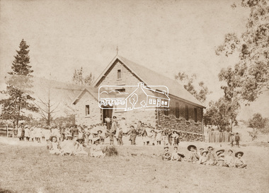
Photograph, Eltham State School No. 209, Dalton Street, Eltham, c.1895
Second school building on same site, which was put out for tender in April 1875. The stone building is prior to any additions. Note children playing in school yard. Published in Nillumbik Mail Edition 21, 20 Sep Harry Gilham's notes: Constructed 1875. Inspection finished 31 December 1875 - outer walls covering said to come from Quarry Park at the western end of cuyrrent Lavender Park Road, Eltham. Windows altered in the 1900s; ventilation and skylights 1920s - built to house 100 children.Sepia photograph mounted on cardNillumbik Mail publication details; Edition 21, 20 Sepdalton street, eltham, eltham state school no. 209, school group, eltham primary school -
 Warrnambool and District Historical Society Inc.
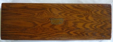
Functional object - Box Swinton Collection, Mid 20th century
This box comes from the Swinton collection and belonged to Alex Swinton. The Swinton family are a pioneering family in Warrnambool with William and Ann Swinton arriving in the town in 1854. Swinton businesses (stores selling furnishings, produce, hardware, clothing, glassware etc.) have been important in Timor Street, Warrnambool since 1865 and are among the oldest family businesses in Australia. Alexander Swinton (1907-1986) was the son of George and Florence Swinton of Merri Crescent Warrnambool. He attended Warrnambool Technical School in the early 1920s. This box is of minor interest as a memento of Alexander Swinton, a prominent member of a prominent Warrnambool family.This is a rectangular-shaped wooden box. It has a rough surface base suggesting that it once was covered in some type of cloth. The top and the sides have a brown varnished surface with a marbled finish. The remains of a metal plaque are in the centre of the top. The inside of the box suggests that it was originally padded to fit a particular object. The lid has two metal hinges and the two catches on the side are metal. Some lettering inside is encased in the outline of a shield and a triangle. Union Case …. Trade Mark H.Coward (or Goward) alexander swinton, warrnambool, history of warrnambool, swinton -
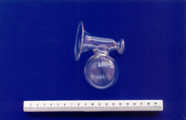
 Royal Australian and New Zealand College of Obstetricians & Gynaecologists (RANZCOG)
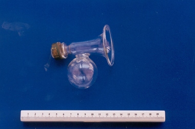
Breast pump associated with midwife Mary Howlett, c. 1866 - 1920
These breast pumps were also known as breast relievers or breast exhausters. They were a refinement of the much earlier 'sucking glass'. The breast pump was refined during the Victorian age. Glass breast pumps were used to manually express milk for the infant. These pumps were in use from the early 1920s to the late 1960s. They can also be used to stimulate lactation. These pumps were widely used in the 1950s by mothers of premature babies. The milk was expressed by hand in the home, then transported to the hospital to feed the premature infant. Mary Howlett (1840-1922) began practising as a country midwife in 1866 in the western district of Victoria. She qualified as a 'ladies monthly nurse' in 1887 and continued to practise as a nurse and midwife until 1920.She began her six months training at the Melbourne Lying-In Hospital. She was known by many as 'Auntie', and her career spanned more than 50 years. Mrs Howlett's midwifery box and contents were given to Dr Frank Forster, and he donated them to the museum collection in 1993.Glass breast pump with brass screw attachment and remnants of rubber pump. Pump is loosely bell shaped with a glass bowl attached to the side of the bell.infant feeding, midwifery -
 Royal Australian and New Zealand College of Obstetricians & Gynaecologists (RANZCOG)
Breast pump associated with midwife Mary Howlett, c. 1866 - 1920
These breast pumps were also known as breast relievers or breast exhausters. They were a refinement of the much earlier 'sucking glass'. The breast pump was refined during the Victorian age. Glass breast pumps were used to manually express milk for the infant. These pumps were in use from the early 1920s to the late 1960s. They can also be used to stimulate lactation. These pumps were widely used in the 1950s by mothers of premature babies. The milk was expressed by hand in the home, then transported to the hospital to feed the premature infant. Mary Howlett (1840-1922) began practising as a country midwife in 1866 in the western district of Victoria. She qualified as a 'ladies monthly nurse' in 1887 and continued to practise as a nurse and midwife until 1920.She began her six months training at the Melbourne Lying-In Hospital. She was known by many as 'Auntie', and her career spanned more than 50 years. Mrs Howlett's midwifery box and contents were given to Dr Frank Forster, and he donated them to the museum collection in 1993.Glass breast pump. Pump is loosely bell shaped with a glass bowl attached to the side of the bell.infant feeding, midwifery -
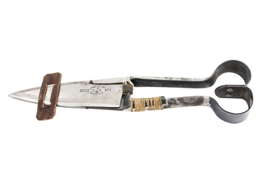 National Wool Museum
Shears
Used from mid 1920s to late 1960s. Shears were used by Mr Embling and with leather scabbard. Made by Mr Embling in his first year at Dookie Agriculture College and were entered in R.A.S in Melbourne 1927 and won first prize in its class. Mr Embling used the set on properties such as "Nap Nap", "Wallah", "Narabri", "Bangool", "Skipton", "Lang Kal Kal", "Beaufort", "Nareen" in Western District (Fraser property). These artefacts were generally carried by stockmen or horsemen when crutching sheep.Metal blade shears dressed with appropriate leather and string strapping to suit user and with leather keeper. Handles have been painted blackCOMBINATION/ UTS No 1/SHEFFIELD/ MADE IN ENGLANDshearing, sheep stations management, animal health, embling, mr ken, sheep stations - management -
 Kew Historical Society Inc
Photograph - Brick and Stucco Bungalow, J E Barnes, c.1920
The Kew Historical Society's map collection includes a substantial number of real estate subdivision plans, mainly of Kew but also of surrounding suburbs in Melbourne. Most of the subdivision plans date from the 1920s and 1930s when the districts old homes and local farmland were being split up to accommodate residential growth in the postwar period. These early plans were assembled by a local firm, Jas R Mather & McMillan, which had an office in Cotham Road. Many of the plans, and sometimes photos, were annotated by the agents.Subdivision plans are historically important documents used as evidence for the growth of suburbs in Australia. They frequently provide information about when the land was sold as well as evidence relating to surveyors and real estate and financial agents. The numerous subdivision plans in the Kew Historical Society's collection represent working documents, ranging from the initial sketches made in planning a subdivision to printed plans on which auctioneers or agents listed the prices for which individual lots were sold. In a number of cases, the reverse of a subdivision plan in the collection includes a photograph of a house that was also for sale by the agent. These photographs provide significant heritage information relating house design and decoration, fencing and household gardens.The photograph may also be aesthetically significant depending o the importance of the photographic atelier.Real estate photograph for a local agent by the Kew photographer, Josiah Earl Barnes. The photo is of a weatherboard or brick rendered bungalow with a twisted wire fence. Given Barnes' status a a Kew photographer, the house is probably locate din Kew or East Kew. Unfortunately the handwritten information on the mount bordering the photo is damaged and cannot be read. The bungalow has a gabled, tiled roof with terra cotta finials at the front of both gables. The house has a central doorway, framed by a pseudo portico supported by four wooden columns. On each side of the doorway, at the front, there are paired sash windows, which, like the half-timbered gable, are picked out in a darker colour.Handwritten, mostly illegible description by selling agent on mount surround: " .... in Diningroom, Drawing Rooms, ... Photographers details printed on mount: "J. E. Barnes / Photo / Phone 1966 Haw KEW"houses - kew, bungalows - kew, real estate photographs, j.e. barnes -- photographer -
 Kew Historical Society Inc
Photograph - Victorian Double-fronted Brock Villa, Cotham Road, c. 1919
The Kew Historical Society's map collection includes a substantial number of real estate subdivision plans, mainly of Kew but also of surrounding suburbs in Melbourne. Most of the subdivision plans date from the 1920s and 1930s when the districts old homes and local farmland were being split up to accommodate residential growth in the postwar period. These early plans were assembled by a local firm, Jas R Mather & McMillan, which had an office in Cotham Road. Many of the plans, and sometimes photos, were annotated by the agents.Subdivision plans are historically important documents used as evidence for the growth of suburbs in Australia. They frequently provide information about when the land was sold as well as evidence relating to surveyors and real estate and financial agents. The numerous subdivision plans in the Kew Historical Society's collection represent working documents, ranging from the initial sketches made in planning a subdivision to printed plans on which auctioneers or agents listed the prices for which individual lots were sold. In a number of cases, the reverse of a subdivision plan in the collection includes a photograph of a house that was also for sale by the agent. These photographs provide significant heritage information relating house design and decoration, fencing and household gardens.The photograph may also be aesthetically significant depending o the importance of the photographic atelier.Real estate photographs of a classic double-fronted late Victorian brick villa. It central location in Cotham Road, Kew enabled the selling agent to note its proximity to the tram. With seven rooms, all ‘modern conveniences’, and land of 66×167, the house was to be sold for £1100. The villa has a number of interesting features including a pattern within the slate roof as well as the use of polychrome brickwork under the eaves and on the façade. The intricacy of the cast iron lace is emphasised by the line of projecting wooden blocks above it. The picket gate is painted a different colour to the pickets of the fence. The house has a name (illegible) that is attached to the inset cast iron lace of the central projecting gable in the veranda. Stamped on mount: "Kew. Central. Close tram. / Comfortable Brick Villa. / Containing 7 rooms / Modern conveniences: / Land 66 x 167. Sold 1100 pounds:"houses - kew, victorian villas, real estate photographs, cotham road - kew -
 Kew Historical Society Inc
Photograph - Double-fronted Edwardian Villa, c.1918
The Kew Historical Society's map collection includes a substantial number of real estate subdivision plans, mainly of Kew but also of surrounding suburbs in Melbourne. Most of the subdivision plans date from the 1920s and 1930s when the districts old homes and local farmland were being split up to accommodate residential growth in the postwar period. These early plans were assembled by a local firm, Jas R Mather & McMillan, which had an office in Cotham Road. Many of the plans, and sometimes photos, were annotated by the agents.Subdivision plans are historically important documents used as evidence for the growth of suburbs in Australia. They frequently provide information about when the land was sold as well as evidence relating to surveyors and real estate and financial agents. The numerous subdivision plans in the Kew Historical Society's collection represent working documents, ranging from the initial sketches made in planning a subdivision to printed plans on which auctioneers or agents listed the prices for which individual lots were sold. In a number of cases, the reverse of a subdivision plan in the collection includes a photograph of a house that was also for sale by the agent. These photographs provide significant heritage information relating house design and decoration, fencing and household gardens.The photograph may also be aesthetically significant depending on the importance of the photographic atelier.On the reverse of a subdivision plan of the Palmyra Estate (Kew) is a photograph of a double-fronted Edwardian villa. The weatherboard and stucco house with high brick chimneys provides a clear indication of the style of curtains and gardens in houses of the period. Holland blinds with lace inserts are used in the left front window. They are combined with long lace curtains. The garden, with its curved pathway is bordered with garden beds that include marguerite daisies and roses. Reflecting a new interest in the Australian landscape, tree ferns and ground ferns are planted closer to the house.houses - kew, architecture - edwardian, real estate photographs -
 Kew Historical Society Inc
Plan - Subdivision : Cotham and Glenferrie Roads, J R Mathers & McMillan
The Kew Historical Society's map collection includes a substantial number of real estate subdivision plans, mainly of Kew but also of surrounding suburbs in Melbourne. Most of the subdivision plans date from the 1920s and 1930s when the districts old homes and local farmland were being split up to accommodate residential growth in the postwar period. These early plans were assembled by a local firm, Jas R Mather & McMillan, which had an office in Cotham Road. Many of the plans, and sometimes photos, were annotated by the agents.Subdivision plans are historically important documents used as evidence for the growth of suburbs in Australia. They frequently provide information about when the land was sold as well as evidence relating to surveyors and real estate and financial agents. The numerous subdivision plans in the Kew Historical Society's collection represent working documents, ranging from the initial sketches made in planning a subdivision to printed plans on which auctioneers or agents listed the prices for which individual lots were sold. In a number of cases, the reverse of a subdivision plan in the collection includes a photograph of a house that was also for sale by the agent. These photographs provide significant heritage information relating house design and decoration, fencing and household gardens.The photograph may also be aesthetically significant depending on the importance of the photographic atelier.An undated and untitled hand-drawn and coloured subdivision plan detailing the boundaries of a number of irregular allotments bordering Cotham Road, Glenferrie Road and Stirling Avenue (now Stirling Street). The plan predates the actual subdivision that led to the creation of the eight commercial properties occupying 118-132 Cotham Road. The plan may represent an old subdivision that was further subdivided at a later date, or it may be a subdivision that never eventuated. On MMBW Detail Plan 1575 (1903), the area represented by the proposed subdivision was residential rather than commercial. The irregularity of lots is also apparent in the MMBW Plan. The largest of the unnumbered blocks on the hand-drawn subdivision plan may relate to the boundaries of the nineteenth century mansion identified as ‘Kelso’ on the MMBW Plan.subdivision plans - kew, cotham road - kew,, glenferrie road - kew , stirling avenue street - kew -
 Kew Historical Society Inc
Plan - Subdivision Plan, J R Mathers & McMillan, Myrtle Hill Estate, East Kew, circa 1949, c.1949
The Kew Historical Society's map collection includes a substantial number of real estate subdivision plans, mainly of Kew but also of surrounding suburbs in Melbourne. Most of the subdivision plans date from the 1920s and 1930s when the districts old homes and local farmland were being split up to accommodate residential growth in the postwar period. These early plans were assembled by a local firm, Jas R Mather & McMillan, which had an office in Cotham Road. Many of the plans, and sometimes photos, were annotated by the agents.Subdivision plans are historically important documents used as evidence for the growth of suburbs in Australia. They frequently provide information about when the land was sold as well as evidence relating to surveyors and real estate and financial agents. The numerous subdivision plans in the Kew Historical Society's collection represent working documents, ranging from the initial sketches made in planning a subdivision to printed plans on which auctioneers or agents listed the prices for which individual lots were sold. In a number of cases, the reverse of a subdivision plan in the collection includes a photograph of a house that was also for sale by the agent. These photographs provide significant heritage information relating house design and decoration, fencing and household gardens.The photograph may also be aesthetically significant depending on the importance of the photographic atelier.Myrtle Hill, at 14 Vista Avenue, Kew, is of local historical and architectural significance as a good example of a large and imposing single-storey Italianate house of the early 1870s surviving in Kew. Originally sited on a large allotment overlooking Normanby Road, the setting of the house has been dramatically altered through extensive subdivision and development. The subdivision plan of the ‘Myrtle Hill Estate’ indicates that in one such subdivision, 11 allotments were created fronting Bowyer Avenue, Myrtle Avenue, and Normanby Road. The outline and building profile of Myrtle Hill is shown on the west side of Bowyer Avenue.The full (typed) title of this subdivision plan is :"Plan of SUBDIVISION of part of CROWN PORTION 83. / at KEW / PARISH OF BOROONDARA. / COUNTY OF BOURKE". / "MYRTLE HILL ESTATE / EAST KEW" In addition to the Title and subtitle, the plan also lists the advantages of the subdivision. -
 Kew Historical Society Inc
Plan - Subdivision Plan, J R Mathers & McMillan, Normanby Estate, c.1913
The Kew Historical Society's map collection includes a substantial number of real estate subdivision plans, mainly of Kew but also of surrounding suburbs in Melbourne. Most of the subdivision plans date from the 1920s and 1930s when the districts old homes and local farmland were being split up to accommodate residential growth in the postwar period. These early plans were assembled by a local firm, Jas R Mather & McMillan, which had an office in Cotham Road. Many of the plans, and sometimes photos, were annotated by the agents.Subdivision plans are historically important documents used as evidence for the growth of suburbs in Australia. They frequently provide information about when the land was sold as well as evidence relating to surveyors and real estate and financial agents. The numerous subdivision plans in the Kew Historical Society's collection represent working documents, ranging from the initial sketches made in planning a subdivision to printed plans on which auctioneers or agents listed the prices for which individual lots were sold. In a number of cases, the reverse of a subdivision plan in the collection includes a photograph of a house that was also for sale by the agent. These photographs provide significant heritage information relating house design and decoration, fencing and household gardens.The photograph may also be aesthetically significant depending on the importance of the photographic atelier.The Normanby Estate, which was adjacent to Normanby Road, Kew East, included thirty-one lots for sale. Streets on the subdivision plan include Adeney Avenue, Park Hill Road, Normanby Road, Weir Street and Wharton Street. Cotham Road and its tramway are shown nearby. The plan is interesting as it shows Wharton Street, named after the architect and town planner George Wharton, who was the first chairman of the Municipality of Kew. The street was to later be renamed Cecil Street. Also shown are proposed ‘Municipal Gardens’ where Parkhill Drive is now located."D" in top left corner. Stamped auctioneers contact details: "Jas. R. Mathers & Son & McMillan / Auctioneer & Land Salesmen, / 271 Collins Street / Melbourne" and Jas. R. Mathers / Estate & Financial Agent / Cotham Road / Kew".weir street - kew, wharton street - kew, normanby road - kew, cotham road - kew, municipal gardens - kew, park hill parkhill road - kew, braemar - kew, subdivision plans - kew -
 Kew Historical Society Inc
Plan, J R Mathers & McMillan, Sackville, Thomas & Lytton Streets, Kew, Twentieth Century
The Kew Historical Society's map collection includes a substantial number of real estate subdivision plans, mainly of Kew but also of surrounding suburbs in Melbourne. Most of the subdivision plans date from the 1920s and 1930s when the districts old homes and local farmland were being split up to accommodate residential growth in the postwar period. These early plans were assembled by a local firm, Jas R Mather & McMillan, which had an office in Cotham Road. Many of the plans, and sometimes photos, were annotated by the agents.Subdivision plans are historically important documents used as evidence for the growth of suburbs in Australia. They frequently provide information about when the land was sold as well as evidence relating to surveyors and real estate and financial agents. The numerous subdivision plans in the Kew Historical Society's collection represent working documents, ranging from the initial sketches made in planning a subdivision to printed plans on which auctioneers or agents listed the prices for which individual lots were sold. In a number of cases, the reverse of a subdivision plan in the collection includes a photograph of a house that was also for sale by the agent. These photographs provide significant heritage information relating house design and decoration, fencing and household gardens.The photograph may also be aesthetically significant depending on the importance of the photographic atelier.Lithographed subdivision plan for an un-named estate with 28 allotments facing Lytton, Sackville and Thomas Streets in Kew. The land would have originally formed part of the Dumaresq Estate. subdivision plans - kew, lytton street, sackville street, thomas street - kew -
 Kew Historical Society Inc
Plan - Subdivision Plan, Jas R Mathers Son & McMillan, Eastlawn Estate : East Kew Auction Sale, 1914
The Kew Historical Society's map collection includes a substantial number of real estate subdivision plans, mainly of Kew but also of surrounding suburbs in Melbourne. Most of the subdivision plans date from the 1920s and 1930s when the districts old homes and local farmland were being split up to accommodate residential growth in the postwar period. These early plans were assembled by a local firm, Jas R Mather & McMillan, which had an office in Cotham Road. Many of the plans, and sometimes photos, were annotated by the agents.Subdivision plans are historically important documents used as evidence for the growth of suburbs in Australia. They frequently provide information about when the land was sold as well as evidence relating to surveyors and real estate and financial agents. The numerous subdivision plans in the Kew Historical Society's collection represent working documents, ranging from the initial sketches made in planning a subdivision to printed plans on which auctioneers or agents listed the prices for which individual lots were sold. In a number of cases, the reverse of a subdivision plan in the collection includes a photograph of a house that was also for sale by the agent. These photographs provide significant heritage information relating house design and decoration, fencing and household gardens.The photograph may also be aesthetically significant depending on the importance of the photographic atelier.The ‘Eastlawn Estate’ was surveyed and ready for auction in March 1914, three months before the outbreak of World War I. Sixty-six allotments, created on the ‘order of Mr & Miss Preston’ surrounded the mansion of Woodlands in Harp Road. Woodlands formed part of the Estate, being advertised as lot 1. The allotments faced High, Station and Wright Streets, Harp and Normanby Roads, and Woodlands Avenue. Pru Sanderson in the Kew Conservation Study (Vol.2, 1988) wrote that the Eastlawn Estate ‘covered the western half of the failed Harp of Erin Estate’. Contemporary advertisements promoted the Eastlawn Estate as: ‘There will be no more convenient district nor pleasant Suburb than East Kew for the busy business man. When the Electric Tram is laid, he will be able to journey quickly and pleasantly direct from Collins Street to his home in the Eastlawn Estate in about 20 minutes’. The actual plans of subdivision were included in advertisements in The Argus and in the local newspapers."C" top left. Various annotations.subdivision plans - kew, station street, normanby road, high street, woodlands avenue, harp road, woodlands - kew -
 Kew Historical Society Inc
Plan - Subdivision Plan, Winton Estate, East Kew : Sale of 10 Building Blocks, 1920
The Kew Historical Society's map collection includes a substantial number of real estate subdivision plans, mainly of Kew but also of surrounding suburbs in Melbourne. Most of the subdivision plans date from the 1920s and 1930s when the districts old homes and local farmland were being split up to accommodate residential growth in the postwar period. These early plans were assembled by a local firm, Jas R Mather & McMillan, which had an office in Cotham Road. Many of the plans, and sometimes photos, were annotated by the agents.Subdivision plans are historically important documents used as evidence for the growth of suburbs in Australia. They frequently provide information about when the land was sold as well as evidence relating to surveyors and real estate and financial agents. The numerous subdivision plans in the Kew Historical Society's collection represent working documents, ranging from the initial sketches made in planning a subdivision to printed plans on which auctioneers or agents listed the prices for which individual lots were sold. In a number of cases, the reverse of a subdivision plan in the collection includes a photograph of a house that was also for sale by the agent. These photographs provide significant heritage information relating house design and decoration, fencing and household gardens.The photograph may also be aesthetically significant depending on the importance of the photographic atelier.Subdivision plan for the so-called Winton Estate in East Kew. The Estate comprised 10 lots facing Simpson Street and Campbell Street. The estate was auctioned by Jas. R. Mathers, Son and McMillan. campbell street, simpson street, hunter street, normanby road - kew, subdivision plans - east kew, subdivision plans - kew -
 Kew Historical Society Inc
Plan - Subdivision Plan, Argyle Road, Heather Grove, Victor Avenue, Kew, c.1937
The Kew Historical Society's map collection includes a substantial number of real estate subdivision plans, mainly of Kew but also of surrounding suburbs in Melbourne. Most of the subdivision plans date from the 1920s and 1930s when the districts old homes and local farmland were being split up to accommodate residential growth in the postwar period. These early plans were assembled by a local firm, Jas R Mather & McMillan, which had an office in Cotham Road. Many of the plans, and sometimes photos, were annotated by the agents.Subdivision plans are historically important documents used as evidence for the growth of suburbs in Australia. They frequently provide information about when the land was sold as well as evidence relating to surveyors and real estate and financial agents. The numerous subdivision plans in the Kew Historical Society's collection represent working documents, ranging from the initial sketches made in planning a subdivision to printed plans on which auctioneers or agents listed the prices for which individual lots were sold. In a number of cases, the reverse of a subdivision plan in the collection includes a photograph of a house that was also for sale by the agent. These photographs provide significant heritage information relating house design and decoration, fencing and household gardens.The photograph may also be aesthetically significant depending on the importance of the photographic atelier.Undated blue subdivision plan in Kew of 14 lots facing Argyle Road, Heather Grove and Victor Road. The Plan identifies Tuxen & Miller as the surveyors. [Formerly catalogued as MAP.0059]subdivision plans - kew, argyle road - kew, heather grove - kew, victor avenue - kew -
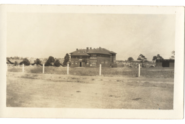 Kew Historical Society Inc
Postcard - Kew East State School No.3161, 35 Kitchener Street, c.1927
What is now Kew East Primary School was opened on its current site in Kitchener Street in 1923. The Kew East and Mont Albert Heritage Gap Study (August 2020) established that: 'Kew East Primary School No. 3136 is historically significant for the evidence it provides of an early phase in the development of Kew East which gathered momentum from the 1920s, as housing developed rapidly and the population increased in response to the extension of the High Street tram to Harp Road then Burke Road then improved tram connections between the area and the city.'A rare and early photograph of the school taken four years after its construction. Small, sepia coloured photographic positive of East Kew State School. The two storey red brick building was opened in 1923. This view, three years after its construction shows preliminary fencing and undeveloped playing grounds.schools -- kew east (vic.), government schools -- kew -- kew east, strathalbyn street -
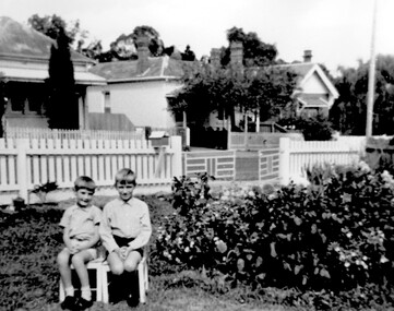 Surrey Hills Historical Society Collection
Photograph, Ray & David Theodoridis of Russell Street, 1960s
The boys have been identified as *Rea & David Theodoridis. they being 2 of 5 children of Peter and Ruth (nee Dawson) Theodoridis. Background shows Nos 11, 13 and 15 Russell Street in the 1960's. In the 1920s-1930s these were the homes of the Scott, Daniels & Hendy families. No 11 was the home of the Scott family (dem); no 13 may also have belonged to the Scott family. No 18 Russell Street, the family home of Eleanor (Lena) & Rea Dawson. * spelling authenticated by Theodata Williams Dec 2019A black and white photograph of two young boys sitting on small chairs in a front garden. There are two houses in the background on the other side of the road.russell street, surrey hills, scott family, daniels family, hendy family, (mr) david theodoridis, (mr) george david theodoridis, (mr) rae theodoridis -
 Surrey Hills Historical Society Collection
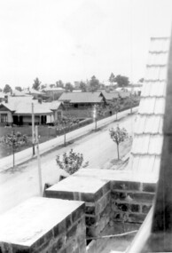
Photograph, Union Road looking west from the steeple of Holy Trinity Church, 1922, 1922
At the edge of the church roof and on the horizon is 'The Knoll' on the corner of Union Road and Wandsworth Road. To the left of this is 297 Mont Albert Road, home of the Michael Parer family and further left is "Quamby", home of the Sherar family. This is easily recognised by the square viewing tower located on the west wing of the house. The Sherar family owned 'Quamby' from 1900 until 1925, when it became Mosgiel Private Hospital. Norman Carter took many photos of Surrey Hills and Mont Albert in the 1920s; many associated with events and activities of the Church of England. Black and white photo of taken from the steeple of Holy Trinity Church, during its construction, across Union Road to the north-west. In the foreground immature street trees can be seen and an original telephone pole with white insulators. The street has formed paths and bluestone kerb and channelling. holy trinity anglican church, union road, the knoll, quamby, street trees, telegraph and light poles, mosgiel hospital -
 Royal Australian and New Zealand College of Obstetricians & Gynaecologists (RANZCOG)
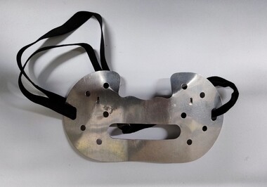
Equipment - Protective metal dust mask associated with Dr Lorna Lloyd-Green
This style of mask was developed in Britain and began to appear from the 1930s, though original models may have been produced in the 1920s. Various patents for this style of mask were still being filed in the 1960s, so they were used for a considerable period of time. It is possible that the original filter pads for these masks contained asbestos, as they supposedly utilised 'fire proof' materials. Asbestos was already in use in other British respirator masks at this time. Original cataloguing information believed this item to be an eye shield, but further research has indicated that this is not the case.Mask consists of a metal plate designed to cover the lower half of the face. There is a recess along the top edge of the plate designed for the nose to sit in. There is a large oblong opening with rounded corners at the centre of the mask, which is a mouth opening to assist speech and is the main air intake. There are five round holes on either side of the mask, likely included to decrease the mask's breathing resistance for the wearer. Rounded slots at each edge of the mask are threaded through with an elastic strap, used for attaching the mask to the face. This mask would have been used with a filtering pad attached, but the pad is missing. -
 The Beechworth Burke Museum
Photograph - Photograph - Reproduction, c1920
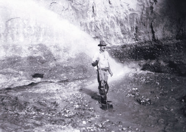
This photograph depicts mining operations (in particular, hydrolic sluicing) at Three Mile Mine, Barramutha, during the later periods of mining, 1920s-1950s. Three Mile Mine was a major site of mining activity sating back to the 1850s, although was often not as prosperous as other sites such as those situated on the Woolshed Valley. Many miners would leave Three Mile Mine for better prospects on other claims. The main, most successful 'rush' at Three Mile Mine occurred during and immediately following September 1855. This photograph, however, depicts a much later period.The search for gold is ingrained into the history of Victoria and therefore, images like this one which portray a miner at a sluicing site can reveal important information for society and technology for the date when the photograph was taken. This image, and its related images, it important for its historical significant of labour and mining extraction used for gold during the latter gold rushes in the 1900s. The Beechworth Burke Museum has additional images relating to gold mining in the region which can be analysed and studied alongside images like this one.A black and white rectangular photograph printed on matte photographic paperreverse: 7597.4 / copied from original on loan from Webb (Qld) / Donated Nov 2009 / Baarmutha Three Mile Mine 1920-1950 / Owned by Plain Bros then Parkinsons / John Weir or Jack Cox / Sluicing /mining, barramutha, three mile mine, sluicing, mine, beechworth -
 Warrnambool and District Historical Society Inc.
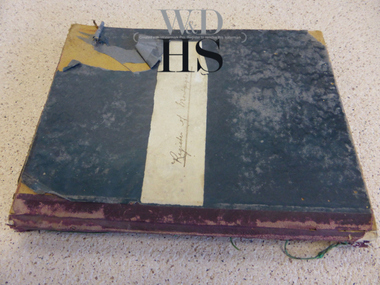
Book, Register of Mortgagees, Early 20th century
This Register of Mortgagees comes from the Warrnambool legal firm of Fletcher and Mackay which resulted from the merger of the firms of George Sutherland Mackay and James Fletcher in 1893. G.S. Mackay was a prominent resident of Warrnambool from 1891 to his death in 1926. In the 1920s Mr J. Taylor became a partner in the firm known then as Mackay and Taylor and the firm later known as Mackay Taylor was in operation until the 1990s at 131 Kepler Street. The Register of Mortgagees with dates ranging from 1908 to 1924 comes from the old Mackay Taylor offices in the Kepler Street building.This Register of Mortgagees is of some significance as it contains information on many families living in Warrnambool in the early 20th century, including those of Burleig, Swinton, Uebergang, Turland, Bates, Wood and Paton. The entries have social significance, showing the typical loans taken out at the time and the prevailing interest rates. This is a small quarto sized ledger containing 166 pages of a register of mortgagees. The pages have been printed with ruled red lines. The cover is bound with a black cover and a red spine. There are pages with alphabetical tabs at the start of the book. The entries are in black ink. There is one loose page which is an old envelope used as scrap paper to record names and amounts owing or paid. Front cover (paper pasted on) – ‘Register of Mortgagees’mackay taylor legal firm warrnambool mortgagees, warrnambool mortgagees, swinton, uebergang -
 Warrnambool and District Historical Society Inc.
Book, Receipt book, Late 19th century
This receipt book was used in the law business of the Warrnambool lawyer, George Mackay (1891 to 1893) and the amalgamated firm of James Fletcher and George Mackay (1893 to 1910). George Mackay was a prominent Warrnambool lawyer, active in the civic and community affairs of the town and the firm of Fletcher and Mackay was an important one in Warrnambool over the time covered by the entries in the receipt book. In the 1920s the firm became Mackay and Taylor when J. Taylor joined as a partner and was a well-known legal firm in Warrnambool until the 1990s. The book was found in the old Mackay Taylor offices in Kepler Street. WarrnamboolThis is a ledger with a dark green binding and black tape on the spine. There are 176 pages plus an alphabetical listing at the back. Most of the entries are receipts that have been pasted into the ledger with some additional written material. The entries are mostly written in black ink with some seals and stamps attached. The receipts are overwritten with ticks and initials in red crayon. Front cover: ‘Receipt Book, From 14.11.1891 To 29.1.1910’ Spine: ‘14-11-1891 to 29-1-10 Receipt Book’ george mackay, warrnambool fletcher and mackay -
 Warrnambool and District Historical Society Inc.
Functional object - Seal: Woodford Mechanics Institute, 19th century
Mechanics Institutes were first established in the 19th century in Scotland and England to improve the education of working class men and to instruct them in their various trades. In Australia Mechanics’ Institutes were set up in the late 1920s with the first one in Melbourne dating from 1839. The Institutes in Victoria were (and some still are) a feature of Victorian country towns, usually consisting of a hall containing a Library and in bigger centres art class rooms and other recreation areas. The Woodford Mechanics’ Institute was established in 1861, enlarged in 1868 and burnt down in 1917.This seal is of major interest as it is the only seal we have of Mechanics’ Institutes in our district. These Mechanics’ Institutes were very important in the educational and social development of Victorian country towns. This is a seal or stamp made of brass and attached to a wooden handle. The wood on the handle is of a dark colour and is urn-shapedStamp - Woodford Mechanics Institutemechanics’ institutes, woodford, early mechanic institute seal -
 Glen Eira Historical Society
Letter - Eskdale Road, 90, Caulfield North
A one page handwritten letter from Alan Douglas to the Glen Eira Historical Society, dated 19/02/04, regarding his donation of eleven professional photographs of the interior, exterior and garden at 90 Eskdale Road, Caulfield, taken by Muntz Studios, possibly in the 1920s. The letter also provides brief details of ownership of the property. Also included is a one page typed reply from the Glen Eira Historical Society, dated 23/03/2004. The file also includes the eleven black and white photographs (130mm x 202mm) of the property.jones james norman, jones winifred gardner, davies winifred, eskdale road, caulfield, caulfield north, douglas alan, douglas barbara kathleen, livingstone-muntz d, muntz studios pty ltd