Showing 1045 items matching "main office"
-
 Eltham District Historical Society Inc
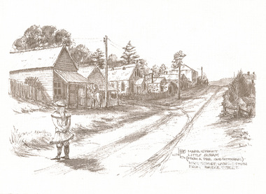
Print, Don Brown, Maria Street, Little Eltham (from a pre 1900 photograph) - Main Street looking south from Bridge Street, 1980
Greeting card from Neville Emerson and Staff with sketch commissioned by Neville Emerson Real Estate. Church is Methodist, built 1880. Eltham Hotel is the square building on the left hand side of the road at apex of Maria St, built 1852. Post Office is on the left side of road above the child's head. Note only telegraph lines on top of poles: phone still being "invented". Print of ink sketch, reproduced as greeting cardart, emerson real estate, bridge street, little eltham, main road, maria street, don brown -
 Linton and District Historical Society Inc
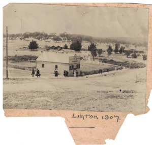
Photograph, Grenville Standard Newspaper Office, Linton 1907
Black and white image of people walking past a building in the main street of Linton. Early LDHS index to photographs says that the people walking along Clyde Street were "probably [in Linton] for Highland sports". Image has been glued to a piece of backing paper.newspapers, printers, railway stations -
 Warrnambool and District Historical Society Inc.
Booklet - Booklet Collection: City of Warrnambool Tourist Guides, Collett, Bain and Gaspar, Warrnambool
This is a collection of sixteen tourist guides dating from the mid 1970's to 2013. These contain listings of businesses, accommodation, eateries and events in Warrnambool and district. They also include maps of Warrnambool and surrounds, advertising and photographs of various attractions. While mainly covering Warrnambool a small number of the guides cover the South West Region. These directories have mainly been published by the Warrnambool City Council and are a selection of the types of information provided to visitors at the Tourist information centre during this time period.These tourist guides give snapshots of the City of Warrnambool for the years covered and will be useful for research.[.1] An 8 page paper booklet with black printing and a black & white photo of the pond at the Botanical Gardens on the front cover. [.2] two photocopied A4 black and white pages from the book "On the Trail" K Winser 1956 (Main Roads of Australia) [.3] A trifold colour brochure with a stylised map of the coast on the yellow and blue front cover. The inside has stylised colour drawings on Warrnambool attractions. The rear cover has coloured photographs of bush, Liebig Street and Fletcher Jones gardens [.4] A trifold black and white brochure with a black line drawing of a whale on the front cover. [.5] A trifold white card with mauve printing. The front cover has a line drawing of the former Timor Street post office and a map of businesses and landmarks in Timor Street. The reverse side contains a brief history of Warrnambool. [.6] A 98 page stapled booklet with a foreword by Vanda Savill. There are 4 pages of coloured photographs. The remainder are black and white photographs. The front cover is purple with white writing in the lower third. There is an outline of the coast and five colour photographs of district attractions. The inside middle page has a map of the Western wonderland region. The content covers towns in this area. Content relating to Warrnambool is in the last six pages. [.7] Twelve loose photocopied black and white pages. The front cover has the Warrnambool Premier Town 1988-1991 logo and a photo of a Southern Right Whale and calf. The bottom right hand corner has a Standard Warrnambool logo. [.8] 44 page booklet printed with blue ink. The staples have been removed. The glossy front cover has blue printing with a coloured photo of Flagstaff Hill Maritime Village pond. The centre pages has a fold out map of the City of Warrnambool. The rear cover has photos of The Twelve Apostles and Hopkins Falls. [.9] 4 loose photocopied pages with Warrnambool Library and Corangamite Regional Library Service Warrnambool City Library black ink stamps. The front page line drawing illustrations of Warrnambool attractions [.10] A single sheet of glossy white paper folded in half to make four pages. The front page has a Warrnambool premier town logo 1979-1982 and blue printing and a visitor survey. [.11] A conference pack of light card folded to make a pocket containing three brochures, a shipwreck coast tourist directory and a Australian Heritage Parks Association conference program dated 24 to 27 May 1992. The front cover of the pack has green writing over a stylised upward arrow. There is a City of Warrnambool logo in the top right hand corner and two film strips diagonally across the cover containing photographs of Warrnambool. The rear cover has a coloured Warrnambool Premier Town logo. [.12] A 63 page stapled booklet with coloured photographs of Warrnambool. The front cover has black writing on white background. There is a coloured photograph of Flagstaff Hill in the middle of the cover and a Warrnambool City and Visit Victoria logos on the lower edge. The middle pages has a coloured of the city of Warrnambool with an inset map of Allansford. [.13] A single large sheet of white paper folded in ten to make a brochure. The front cover has black printing. The rear cover has a purple ink stamp for the City of Warrnambool Tourist Information Centre. When folded out the reverse side has a green, grey and white map of the South West Region of Victoria. [.14] A 48 page colour booklet on glossy paper. The front cover has white writing on a blue background and includes photographs of the Twelve Apostles, the Promenade walk, Flagstaff Hill and a southern right whale's tail. The rear cover has photographs of The Twelve apostles, a passenger train from Melbourne passing the Lake Pertobe playground, and a rural scene. There is white writing and a white Warrnambool City logo on a blue background. The centre pages have a stylised green and blue map of the city of Warrnambool. [.15] A 48 page colour booklet on glossy paper. The front cover has white writing over colour photographs of two people at a lookout, Flagstaff Hill, three southern right whales and a child at the Lake Pertobe playground. The lower edge has blue upper case writing on a white background. The rear cover has a colour photograph of the Twelve Apostles. The lower white border on the rear covers has a a blue and green City of Warrnambool logo and blue writing. The centre pages have a stylised green and blue map of the city of Warrnambool. [.16] A 64 page colour booklet on glossy paper. The front cover has black writing on a black background and there is a photograph of a southern right whale's tail. The lower edge has the Warrnambool City and Visit Victoria Logos. The centre pages have maps of Warrnambool and surrounds. [.1] This week in Warrnambool Vol 2 No. 5 Thurs 1st Feb. For the time of your life [.2] Warrnambool Way [.3] Warrnambool The Holiday Host on the South West Coast with compliments City of Warrnambool and Warrnambool Chamber of Commerce [.4] MMI Insurance presents Whales Giants of the Deep Whale Watcher's Logbook Warrnambool [.5] Warrnambool History began in Timor Street [.6] Western Wonderland Tourist Association [.7] A Premier Arrow Tour of Warrnambool Victoria's Premier Town Australia's Southern Right Whale Nursery [.8] Warrnambool The Heart of Victoria's Great Southwest Visitor's Handbook [.9] What to see in Warrnambool Victoria's Premier City 1979-1982 [.10] Win a Free Holiday & $200 Cash in Victoria's Premier Town [.11] Advancing Warrnambool together! [.12] Great Ocean Road Warrnambool Official Visitor Guide [.13] Tourist guide to the South West Region Victoria All it needs is you [.14] Warrnambool visitor guide 2005 the great ocean road experience attractions accommodation entertainment dining [.15] Warrnambool Visitor Guide 2006 the great ocean road experience Attractions Accommodation Entertainment Dining [.16] Official Visitors' Guide Warrnambool Victoria Australia Discover the Great Ocean Road warrnambool, warrnambool tourist guides -
 Bacchus Marsh & District Historical Society
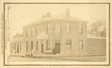
Photograph, Simpsons Butchery Main Street Bacchus Marsh 1883
John Simpson arrived in Bacchus Marsh around 1848. In 1850 he established a butchery business. He continued to operate this business in Main Street Bacchus Marsh until his death in 1890. His son John Simpson and one of his brothers, Edward took over the business and operated it until 1923. John Simpson the younger died in 1940 having lived all but a few months of his 92 years in Main Street Bacchus Marsh. Edward L. Simpson died in Corowa, NSW in 1937. The younger John Simpson's recollections of Bacchus Marsh in the 1850s to 1870s were published in the Bacchus Marsh Express on the 25 June 1932.Small sepia unframed photograph on card with gold border framing photograph. Housed in the album, 'Photographs of Bacchus Marsh and District in 1883 by Stevenson and McNicoll'. The image shows a butchery shop in Main Street Bacchus Marsh in 1883. The front of the building is shown. It is a solid brick or stone structure with a shingled roof and verandah. Hanging under the verandah are numerous carcasses and portions of meat. Two men are standing close together in front of the shop. One is wearing a butcher's apron. Another man to the left sits upon a horse. In the doorway behind the men stands a woman. On the front: Stevenson & McNicoll. Photo. 108 Elizabeth St. Melbourne. COPIES CAN BE OBTAINED AT ANY TIME. On the back: LIGHT & TRUTH inscribed on a banner surmounted by a representation of the rising sun. Copies of this Portrait can be had at any time by sending the Name and Post Office Money Order or Stamps for the amount of order to STEVENSON & McNICOLL LATE BENSON & STEVENSON, Photographers. 108 Elizabeth Street, MELBOURNE. stevenson and mcnicoll 1883 photographs of bacchus marsh and district, butcher shops, butchers, john simpson butcher 1848-1940, john simpson butcher died 1890 -
 Bacchus Marsh & District Historical Society
Photograph - Saint Bernard's Roman Catholic Church, Lerderderg Street Bacchus Marsh 1883
This Catholic Church was built between 1872 and 1874. It was the first permanent Catholic Church building in Bacchus Marsh. Catholics had lived in the Bacchus Marsh area since the early 1840s and in this early period religious services had been conducted in a number of different buildings including peoples' homes. This Church still stands and continues to be the main place of worship for Catholics in the Bacchus Marsh area. Small sepia 'carte de viste' style unframed photograph on card with gold border framing photograph. Housed in the Jeremeas Family Album which contains photographs of Bacchus Marsh and District in 1883 by the photographers Stevenson and McNicoll. The image shows Saint Bernard's Catholic Church in Bacchus Marsh nine years after it was erected in 1874. The view of the Church is looking north from somewhere around the present day location of Manor Street Bacchus Marsh. This image was taken before the Presbytery was built in 1889.Printed On the front: Stevenson & McNicoll. Photo. 108 Elizabeth St. Melbourne. COPIES CAN BE OBTAINED AT ANY TIME. On the back: LIGHT & TRUTH inscribed on a banner surmounted by a representation of the rising sun. Copies of this Portrait can be had at any time by sending the Name and Post Office Money Order or Stamps for the amount of order to STEVENSON & McNICOLL LATE BENSON & STEVENSON, Photographers. 108 Elizabeth Street, MELBOURNE. stevenson and mcnicoll 1883 photographs of bacchus marsh and district, churches bacchus marsh, catholic church bacchus marsh, saint bernards roman catholic church bacchus marsh -
 Bacchus Marsh & District Historical Society
Photograph, Timmons. Clothier and Draper. Victoria House. 1883
This building was part of a range of shops known as Victoria House, built by Vere Quaile, blacksmith, in 1857. It consisted of a shop, a blacksmith's forge and wheelwright, and was located to the east of the blacksmith's forge in Main Street. Between 1874 and 1892 Francis Timmons operated a clothier and drapers business in this building.Small sepia unframed photograph on card with gold border framing photograph. The name of the business can be clearly seen above the awning. Less clear is the name "Victoria House', also above the awning. Housed in the album, 'Photographs of Bacchus Marsh and District in 1883 by Stevenson and McNicoll'.On the front: Stevenson & McNicoll. Photo. 108 Elizabeth St. Melbourne. COPIES CAN BE OBTAINED AT ANY TIME. On the back: LIGHT & TRUTH inscribed on a banner surmounted by a representation of the rising sun. Copies of this Portrait can be had at any time by sending the Name and Post Office Money Order or Stamps for the amount of order to STEVENSON & McNICOLL LATE BENSON & STEVENSON, Photographers. 108 Elizabeth Street, MELBOURNE. In handwriting: 'Victoria House'. Clothier + Draper. Main St. c.1857. Next to Blacksmith Cottage. Courtesy Mrs. Jeremeas. Photo 1883.stevenson and mcnicoll 1883 photographs of bacchus marsh and district, shops bacchus marsh vic., clothing shops, drapers bacchus marsh vic -
 Bacchus Marsh & District Historical Society
Photograph, Hall of Commerce, corner Main and Graham Streets, Bacchus Marsh. 1883
Bacchus Marsh Express of 7 November 1874 reports that this building was designed and erected by Mr Jeremiah Ryan for Mr H. G. Salter, draper. Mr Salter gave the name of "Hall of Commerce" to the building, a term in common usage at the time. The building was of a substantial size. In the Express of January 4 1879 Messrs Basham and Bradley advertised a wide variety of goods including drapery, millinery, ready-made clothing, boots and shoes and furniture. At the front of the building was the first pavement in the township. This photo forms a contrast with the photograph (also taken by Stevenson & McNicoll in 1883) of Timmons Clothier and Draper, but depicting an older building from 1857. This business was on the verge of closure, Mr Timmons conducting his business as a travelling salesman, taking his goods by horse and cart to outlying districts. The image provides an example of the growing scale of retail development in Bacchus Marsh in the late nineteenth century.This photograph is a record of a prominent commercial building that has undergone substantial change. The image shows the original upper floor which was destroyed by fire in 1928.The building retains its usage as a commercial premises.Small sepia unframed photograph on card with gold border framing photograph. Housed in the album, 'Photographs of Bacchus Marsh and District in 1883 by Stevenson and McNicoll'. Photograph of a two storey brick building with a front verandah. Various signage on second storey front and side, and on verandah, including: Hall of Commerce. Boots & Shoes. Men and Boy's Clothing. Furniture and Bedding. J. Carter Outfitter. Basham & Bradley. Milliners and Dressmakers. General Drapers. General Drapery. Warehouse. Latter signage obscures earlier signage. The photographer has captured a young girl sitting on a bench at the front of the store.On the front: Stevenson & McNicoll. Photo. 108 Elizabeth St. Melbourne. COPIES CAN BE OBTAINED AT ANY TIME. On the back: LIGHT & TRUTH inscribed on a banner surmounted by a representation of the rising sun. Copies of this Portrait can be had at any time by sending the Name and Post Office Money Order or Stamps for the amount of order to STEVENSON & McNICOLL LATE BENSON & STEVENSON, Photographers. 108 Elizabeth Street, MELBOURNE. Handwritten: Hall of Commerce. Cr. Main + Graham Sts built 1874 by Jeremiah Ryan. Destroyed by fire 1928. Courtesy Mrs. Jeremeas. Photo 1883.stevenson and mcnicoll 1883 photographs of bacchus marsh and district, shops bacchus marsh vic., bacchus marsh hall of commerce -
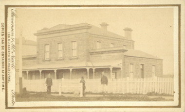 Bacchus Marsh & District Historical Society
Photograph, Court House Main Street Bacchus Marsh 1883
The Court House in Main Street Bacchus Marsh was built in 1858 using local sandstone. It opened in 1859. It has been used for jury trials, a Court of Petty Sessions, a County Court and a Crown Land sales office. Other uses included an office for the Registrar of Births and Deaths, a Dairy Inspectors office from 1863-1865, and as meeting rooms for the Bacchus Marsh Roads Board, a forerunner of the Shire Council. It was also used by the Bacchus Marsh Shire Council for its offices until at least 1884. In more recent years it has functioned as a Magistrates Court with weekly court sessions. Small sepia unframed photograph on card with gold border framing photograph. Housed in the album, 'Photographs of Bacchus Marsh and District in 1883 by Stevenson and McNicoll'. The view of the Court House building is seen from the northern side of Main Street looking south or south-east. Three men are standing in the street in front of the building. The men on the left and the right wearing police helmets appear to be police officers. The man in the middle is in civilian clothes and might be an officer or employee of the Court House. He has his dog with him. A white picket fence runs along the front of the building. The front courtyard of the building has been renovated since, but this building still operates as a court house.On the front: Stevenson & McNicoll. Photo. 108 Elizabeth St. Melbourne. COPIES CAN BE OBTAINED AT ANY TIME. On the back: LIGHT & TRUTH inscribed on a banner surmounted by a representation of the rising sun. Copies of this Portrait can be had at any time by sending the Name and Post Office Money Order or Stamps for the amount of order to STEVENSON & McNICOLL LATE BENSON & STEVENSON, Photographers. 108 Elizabeth Street, MELBOURNE. stevenson and mcnicoll 1883 photographs of bacchus marsh and district, courthouses, bacchus marsh court house -
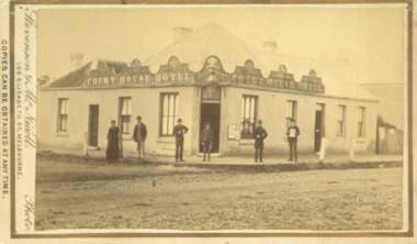 Bacchus Marsh & District Historical Society
Photograph, Court House Hotel Main Street Bacchus Marsh 1883
This building on the corner of Court House Place and Main Street Bacchus Marsh was a licensed hotel since 1864. Prior to 1864 the building was in use as a saddlery business, established by Joseph Purday and Alfred Smith. In 1864, Purday and Alfred Tanner converted the shop to a hotel. Tanner, followed by his wife Ann, were licensees until 1892. The hotel signage above the door features the Prince of Wales feathers, an acknowledgement of the Prince of Wales Volunteer Light Horse Werribee unit which used the hotel for their meetings. In 1911 the single-storey hotel was demolished and a two-storey brick hotel was built. The identities of the five men and one woman in the photo are not known. The woman at the left of the group is possibly Ann Tanner who was the licensee around the time this photograph was taken. Small sepia unframed photograph on card with gold border framing photograph. Housed in the album, 'Photographs of Bacchus Marsh and District in 1883 by Stevenson and McNicoll'. A group of five men and one woman can be seen standing in front of the Court House Hotel building, Main Street Bacchus Marsh. A large ornate sign around the roofline bears the words “Courthouse Hotel”. Above the door a sign featuring the Prince of Wales feathers also has the name “Ann Tanner.” One of the men is displaying a document which apparently is of some importance, now lost.On the front: Stevenson & McNicoll. Photo. 108 Elizabeth St. Melbourne. COPIES CAN BE OBTAINED AT ANY TIME. On the back: LIGHT & TRUTH inscribed on a banner surmounted by a representation of the rising sun. Copies of this Portrait can be had at any time by sending the Name and Post Office Money Order or Stamps for the amount of order to STEVENSON & McNICOLL LATE BENSON & STEVENSON, Photographers. 108 Elizabeth Street, MELBOURNE. stevenson and mcnicoll 1883 photographs of bacchus marsh and district, hotels bacchus marsh, court house hotel bacchus marsh -
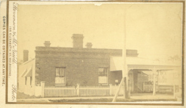 Bacchus Marsh & District Historical Society
Photograph, Cottage built for Doctor Bone Main Street Bacchus Marsh 1883
This building was constructed by James Elijah Crook in 1865 as a residence for Doctor Bone. Between 1874 and 1890 it was in use as a Post Office. From around the 1920s F.C Pearce sold motor cars from this site for a number of years. The site is now occupied by the Bacchus Marsh Newsagency and Stationers located at 138 Main Street.Small sepia unframed photograph on card with gold border framing photograph. Housed in the album, 'Photographs of Bacchus Marsh and District in 1883 by Stevenson and McNicoll'. Image shows a brick cottage with a verandah attached to part of the building. Four brick chimneys can be seen extending from the building. Part of the building has a white picket fence to the front and side.On the front: Stevenson & McNicoll. Photo. 108 Elizabeth St. Melbourne. COPIES CAN BE OBTAINED AT ANY TIME. On the back: LIGHT & TRUTH inscribed on a banner surmounted by a representation of the rising sun. Copies of this Portrait can be had at any time by sending the Name and Post Office Money Order or Stamps for the amount of order to STEVENSON & McNICOLL LATE BENSON & STEVENSON, Photographers. 108 Elizabeth Street, MELBOURNE. stevenson and mcnicoll 1883 photographs of bacchus marsh and district, houses bacchus marsh, post offices bacchus marsh, doctors residences, james elijah crook, motor car dealers -
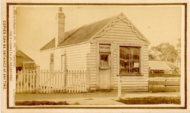 Bacchus Marsh & District Historical Society
Photograph, Saddlery Shop of George Taylor Main Street Bacchus Marsh 1883
This image is one of a series of photographs taken by Melbourne based photographers Stevenson and McNicoll who visited Bacchus Marsh and its nearby districts between September and November 1883. George Taylor was in business in Bacchus Marsh from 1866. He built these premises in Main Street in 1868 and remained in business until 1888 when Samuel Painter brought the property and operated his own saddlery business. The location was later used for the State Savings Bank of Victoria and the Bank of New South Wales (Westpac). The location of this site in 2024 is 136 Main Street, Bacchus Marsh.Small sepia 'carte de viste' style unframed photograph on card with gold border framing photograph. Housed in the album, 'Photographs of Bacchus Marsh and District in 1883 by Stevenson and McNicoll'. The image shows a single storey timber building with a pitched roof. The front of the gable has an ornamental wooden fretwork design attached.The name 'Taylor' can be clearly seen above the front door. There is one large window. The roof appears to be slate and the building has one chimney. Outhouses can be seen to the left and right of the building. There is a picket fence to one side of the building and a post-and-rail fence to the other.Printed On the front: Stevenson & McNicoll. Photo. 108 Elizabeth St. Melbourne. COPIES CAN BE OBTAINED AT ANY TIME. On the back: LIGHT & TRUTH inscribed on a banner surmounted by a representation of the rising sun. Copies of this Portrait can be had at any time by sending the Name and Post Office Money Order or Stamps for the amount of order to STEVENSON & McNICOLL LATE BENSON & STEVENSON, Photographers. 108 Elizabeth Street, MELBOURNE. stevenson and mcnicoll 1883 photographs of bacchus marsh and district, saddleries, saddlers -
 Melbourne Tram Museum
Photograph - Black & White Photograph/s, Keith Kings, 23/10/1946
Black and white photograph of the front of MMTB Hawthorn Depot, 23/10/1946, prior to the reconstruction of the front of both depots. Shows the depot starters office in front of the main building, the brick facades and a number of trams parked in front of the second sheet. No. 339 is on the depot lead. See image i2 for the rear of the photograph giving details. Notes it is on the 3rd day of a tram and train strike. Keith Kings photograph No. A(m)(2) Printed on Kodak Xralife paper.trams, tramways, hawthorn tram depot, depots, tram 339 -
 Melbourne Tram Museum
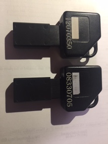
Functional object - Digital memory module, KDM, c1995
Digital Memory module, or Portable Memory Key, equivalent in type to a USB stick, black plastic with sliding mechanism to protect 8 copper contact strips with a digital memory area at one end. Stamped into the memory area part number "109 13858 512K KDM", indicating it had a memory storage of 512Kb. Above the number are the remains of a white bar-code label. Has as key type appearance. .1 - Numbered in white numerals "08330705" .2 - ditto "120703350" Advised by Adam Chandler 20-11-2017: They were used by tram and bus drivers. The PM (portable memory) key was issued to each driver. At the start of a shift, the driver would put it into a cream-coloured terminal at the sign-on point (starter's office in the depot) and transfer their shift information onto the key. Once the driver reached the vehicle, they put the key into the black-coloured terminal (tram driver's keypad - TDKP or bus driver's keypad) to upload the shift data to the vehicle. This was also the method used to transfer the 'blacklist' of periodical passes that had been stolen or misappropriated to each vehicle. IE if an annual Metcard had been stolen, once the holder reported it to Metcard they would blacklist the ticket number and this would be sent out to every depot and piece of equipment. From memory there were 100 slots in the blacklist. When a tram driver was finishing their shift (either being taken or running in) they would transfer all of the validations and ticket sale information to the PM key by inserting it a few minutes before the end of shift and downloading all of this data from the vehicle. They would then be required, on arriving back at the starter's office, to insert the key in the cream coloured terminal once more and copy all of the information across to the main system. Bus drivers also issued tickets from their BDKPs so the black PM key was also used for ensuring the accounting information was copied across to the main system. My memory might be faulty but I recall using them at railway stations with the Booking Office Machines (for starting and finishing shifts). No transfer of ticket issuance data however, as there was a computer equipment cabinet at each railway station with a DSL or cable link back to the OneLink central computers (in the revenue clearing house) I don't know what happened with the MTH cars on the Stony Point rail line but I could presume that there was a cabinet with a TDKP equivalent in it and a similar procedure for start and finish of shift.trams, tramways, ticket machines, metcard -
 Melbourne Tram Museum
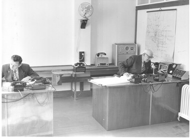
Photograph - Set of 6 Black & White Photograph/s, Melbourne & Metropolitan Tramways Board (MMTB), 1957
Set of six Black and White photographs of the MMTB Radio Centre (used in 1957 Annual Report?) .1 - Photo of the equipment and two people working in the room with multiple telephones, a map and a large book to record events possibly. .2 - as above but a close up of the main desk. .3 - ditto .4 - ditto but with another person at the desk .5 - Photo of one of the mobile cars - a Ford Zephyr - Mark II Saloon which was produced in Australia between 1956 and 1962 See - https://en.wikipedia.org/wiki/Ford_Zephyr accessed 1/3/2021. .6 - internal view of the car with an Inspector on the radio handset and shows other equipment provided. MMTB Photostrams, tramways, radio centre, inspectors, mmtb, head office -
 Melbourne Tram Museum
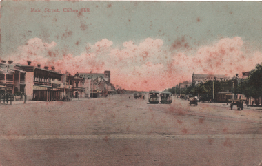
Postcard, "Main Street Clifton Hill", c1900
Colour postcard, with two cable tram sets in Queens Parade Clifton Hil and the buildings on with side of the very wide roadway. Yields information about the view along Queens Parade Clifton Hill.Postcard - colour with divided back, used with a Victorian 1d stamp on the rear.Handwritten note and date stamp of the Clifton Hill Post Office. Has a Christmas Greetings on the rear for a person in Sebastopol.trams, tramways, cable trams, clfiton hill, queens parade -
 Bacchus Marsh & District Historical Society
Photograph, Royal Hotel corner of Main and Young Streets Bacchus Marsh 1883
This image is one of a series of photographs taken by Melbourne based photographers Stevenson and McNicoll who visited Bacchus Marsh nearby districts between September and November 1883. The Royal Hotel was built in 1861 and is located on the corner of Main and Young Streets in Bacchus Marsh. The first owner was James Murray and the hotel was first known as the Murray Family Hotel. James Murray died in an accident in 1863 and sometime after this the ownership passed to Richard Manning. From around 1869 it became known as the Royal Hotel. Richard Manning's son Frederick Manning inherited the hotel in 1896. The Manning family owned the hotel until sometime after 1945. In more recent decades it has been owned and operated by a number of different people. The hotel continues to operate as of 2024. This image shows the building in its original structure. In 1888, five years after this image was taken, a second storey was added to the section on Young Street. In this image this section is the single storey section of wall without windows to the right of the picture. Small sepia 'carte de viste' style unframed photograph on card with gold border framing photograph. Housed in the album, 'Photographs of Bacchus Marsh and District in 1883 by Stevenson and McNicoll'. The image shows the Royal Hotel seen from the intersection of Main and Young Streets. The diagonal view shows both the Main Street and Young Street sides of the building. It is a two storey brick building with a single storey brick extension on the Young Street frontage. Standing at the corner of the building is a woman and five girls. A deep gutter runs along the Main Street, with a pedestrian crossing ramp. Over this crossing point, there is a large metal frame bearing an ornate lantern. Next to it is a water trough for horses. Several hitching posts can be seen along the footpaths.Printed On the front: Stevenson & McNicoll. Photo. 108 Elizabeth St. Melbourne. COPIES CAN BE OBTAINED AT ANY TIME. On the back: LIGHT & TRUTH inscribed on a banner surmounted by a representation of the rising sun. Copies of this Portrait can be had at any time by sending the Name and Post Office Money Order or Stamps for the amount of order to STEVENSON & McNICOLL LATE BENSON & STEVENSON, Photographers. 108 Elizabeth Street, MELBOURNE. stevenson and mcnicoll 1883 photographs of bacchus marsh and district, hotels bacchus marsh, royal hotel bacchus marsh, manning family bacchus marsh, murray family hotel bacchus marsh -
 Bacchus Marsh & District Historical Society
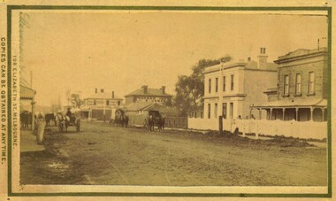
Photograph, Main Street Bacchus Marsh 1883 looking east
View of Main Street Bacchus Marsh 1883, showing early notable buildings on the southern side of the street, including the Courthouse, National Bank of Australasia, Border Inn, Hall of Commerce building. Small sepia unframed photograph on card with gold border framing photograph. Housed in the album, 'Photographs of Bacchus Marsh and District in 1883 by Stevenson and McNicoll'. Several horse-drawn vehicles can be seen travelling along an unmade road. Piles of excavated dirt can be seen along the side of the road. Four substantial two-storeyed buildings can be seen along the southern side of the street.On the front: Stevenson & McNicoll. Photo. 108 Elizabeth St. Melbourne. COPIES CAN BE OBTAINED AT ANY TIME. On the back: LIGHT & TRUTH inscribed on a banner surmounted by a representation of the rising sun. Copies of this Portrait can be had at any time by sending the Name and Post Office Money Order or Stamps for the amount of order to STEVENSON & McNICOLL LATE BENSON & STEVENSON, Photographers. 108 Elizabeth Street, MELBOURNE. stevenson and mcnicoll 1883 photographs of bacchus marsh and district, bacchus marsh roads and streets, bacchus marsh main street 19th century -
 Bacchus Marsh & District Historical Society
Map, Maddingley Township, Parish of Parwan, County of Grant, 1856
Maddingley is a locality or township within the broader township area of Bacchus Marsh. This map is dated 1856 but is based on an earlier survey in 1843. The main area of Maddingley shown on this map is an area bounded by Bacchus Street, Moore Street, Griffith Street and Franklin Street. Other streets visible are Inglis Street, Labilliere Street, McCrae Street. The area to the east of Franklin Street is not sub-divided and is described as an 'alluvial flat. A single page paper map showing land allotments, streets, and natural watercourses in the township of Maddingley. The map is pasted into a bound volume containing 76 maps or plans in total. Two inscriptions: 1. A.J. Skene Surveyor, 1843. ; 2. Surveyor-General's Office Melbourne, Sept 6, 1856. (Lithographed by R. Meikle)bacchus marsh victoria maps, maddingley victoria maps, land use, maddingley victoria history -
 Bendigo Historical Society Inc.
Document - NORTH DEBORAH GOLD MINING CO N. L. - NORTH DEBORAH MISCELLANEOUS REPAIR COSTS
Three small, blue handwritten pages of costs of repairs, with typed copies of same, listing some stores and cost of cartage by W. McCulloch & Co. Dates 1940 - 41. Most of the repairs/installation are electrical, including installation of extra lights, installing wiring for 2.1 H P motor and alteration to main switchboard. Stores include globes, lamps and a hydraulic jack. Note at the bottom: All information from papers found on floor of North Deborah Managers Office. Albert Richardson Collection. document, gold, north deborah gold mining co n. l., north deborah gold mining co n. l., north deborah miscellaneous repair costs, w mcculloch & co, ludowice bell -
 Bacchus Marsh & District Historical Society
Map, Plan of the property of Messers Atkins and Clarke to be sold at the Mansion, Bacchus Marsh 19th April 1856. Copy 1
This plan of land allotments for sale indicates the property once owned by the Bacchus family in and around the township area of Bacchus Marsh. The Bacchus family sold their property in Bacchus Marsh to John Atkins and Robert Nalder Clarke in March 1851. Atkins and Clarke kept the property for a number of years until April 1856 when these allotments were put up for sale.This plan is almost identical to another copy held by the Bacchus Marsh and District Historical Society, VC Record 452, BMDHS collection). This plan, VC Record 707 Copy 1, contains a little more detail overall than VC Record 452 Copy 2, such as who did the survey work for the plan (R.C. Bagot) and who the selling agents were, (W.M. Tennent), and on the right side of the plan near the Lerderderg River is indicated the general area for a second parcel of land from this sale which is to be sold. There is also a compass illustration indicating north and south compass points.This is a very early land sales plan for the township of Bacchus Marsh and it therefore provides some clues as to how the early urban development of the township took place. Upon seeing the map in 1911 Bacchus Marsh Express newspaper editor Christopher Crisp wrote "The sale appears to have created the present township, which had a nucleus in earlier times further east", Express, 30 September, 1911, page 3.A single page paper plan showing allotments of land for sale. The subdivided land shown was owned by John Atkins and Robert Nalder Clarke, but previously owned by the Bacchus Family and was in and around their Manor House (Mansion) property in Bacchus Marsh.There are 5 portions of land further divided into numerous small portions. The land for sale is bounded by the present day streets of Main Street, Young Street, McFarland Street, Morton Streets, Crook Street, and part of the eastern section extends to the Lerderderg River. Scale: 8 chains to 1 inch The plan is pasted into a bound volume containing 76 maps or plans in total. BMDHS Loc: AR/B12/S4 Bacchus Marsh Township and Nearby Districts Maps Volume In-house Digital copies: BMDHS, Computer Network: Maps\Bacchus Marsh Township and Nearby Districts Maps VolumeHeading: Plan of the first portion of land. The property of Messers Atkins and Clarke situate at Bacchus Marsh. To be sold by W.M. Tennent & Co. at the Mansion on the Ground on Saturday the 19th April 1856. Below heading: Jas Ferguson, Lithographer On upper right side: Subdivided by R.C. Bagot London and Liverpool Chambers, Melbourne. 'Thos Taubman'. Post Office Stamp: BACCHUS MARSH VICTORIA MY 6, 63bacchus marsh victoria maps, bacchus family, land sales, manor house bacchus marsh -
 Stawell Historical Society Inc
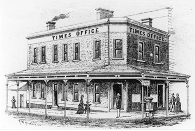
Drawing, Stawell Times Newspaper Office, corner of Main Street Stawell & Patrick Street in the P.C. News Supplement 1888 -- Sketch
... Stawell Times Newspaper Office, corner of Main Street...Stawell Times Office corner of Main Street and Patrick...Stawell Times Office corner of Main Street and Patrick ...Stawell Times Office corner of Main Street and Patrick Street from Sketch in P.C. News Supplement 1888. Built 1875 for Mrs Nihill as the Club Hotel after the previous building burnt down, Architect Michael Ryan Ararat. Verandah erected 1876. Mortgagee's sale of Club Hotel occurred in 1887. Then Stawell Times Office. Bought by the members of Stawell Sub Branch RSL after WW1 in 1920's as Club Rooms and sold when they mover to Oban Building.stawell businesses -
 Stawell Historical Society Inc
Photograph, Main Street Stawell looking East across Wimmera Street to Post Office c1880
Main Street Stawell looking east across Wimmera Street to Post Office. Horse Drawn cart at left of Photo. Star Hotel on right in the distance.B/W Photo Main Street looking east with the Post Office on the left. It is interesting to note that the Star Hotel is way out of line it seems to block the street. It was shifted back and is now the Stawell Club.stawell businesses streetscape -
 Stawell Historical Society Inc
Photograph, Stawell Post Office Cnr Wimmera and Main Streets 1975
... Stawell Post Office Cnr Wimmera and Main Streets 1975...Stawell Post Office on corner of Wimmera and Main Streets ...Stawell Post Office on corner of Wimmera and Main Streets. Erected 1875. Phone box and car at right of photo. Directional sign on the left side of the building. The Fruit Vegs building on the right side has replaced the Akins building on the right side in an earlier photo.Black & white photograph of a two storey building built in 1875. Out the front of the building is a signpost, bench seat, phone box and car in the foreground. A flag pole protrudes from one of the windows on the top storey. On the right side of the photo is a Fruit Vegs sign on the awning of the building next door. A directional sign post is on the left side of the building stawell -
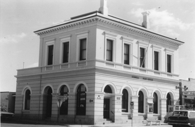
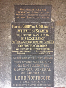 Mission to Seafarers Victoria
Photograph - Digital photograph
The bottom stone was the foundation stone for the main building laid Tuesday 5 February 1907, and the middle stone was the foundation stone for the chapel, laid Tuesday 1 December 1908. The two stones were inserted on the wall of the current Mission building probably when the Siddeley Street institute was demolished. The stones are located in the courtyard on the wall of the former chaplain's office. next to the chapel.The stones are the few remnants of the first Central Institute.Photograph depicting the two foundation stones of the former Seamen's Institute located on Siddeley Street.siddeley street institute, reverend a. gurney-goldsmith, sir thomas david gibson carmichael (1859–1926), governor of victoria, lord henry stafford northcote (1846–1911), governor general of australia, flinders street mission, australian wharf -
 Eltham District Historical Society Inc
Film - Video (VHS), Dynavision Video Production, 1994 Eltham Festival, 11 Nov 1994
20th Eltham Community Festival and last under the auspices of the Shire of Eltham. The Grand Parade focussing on the theme "Echoes of Eltham - Celebrating the visions of Eltrham from the past and into the future" was headed by Jock Read on his horse Lofty who had been filmed in an Anzac Day Parade on an earlier horse which had featured in the television show Matlock. The parade travelled north along Main Street to just past the Post Office then back south to Panther Place. Parade participants included 1st Eltham Brownies, 1st Eltham Venturers, 2nd Eltham Sea Scouts, 2nd Eltham Venturers, 3rd Eltham Brownies, Australian Democrats, Briar Hill Primary School, Circus Chaos, Country Fire Authority, Diamond Valley People for Disarmament, Diamond Valley Railway, Eltham Community Health Centre, Eltham District Horse and Pony Club, Eltham East Primary School, Eltham Fire Brigade, Eltham Junior Football Club (Panthers), Eltham Little Theatre, Eltham North Primary School, Eltham Playhouse Co-op, Eltham Pre-school, Eltham Roller Skating Club, Eltham South Pre-School Centre, Eltham Steam and Stationary Engine Society, Greenhills Neighbourhood House, Heidelberg Municipal Band, Hurstbridge Learning Co-op, Jocklebeary Farm, Kangaroo Ground Primary School, Learning Co-op Primary School, Lower Plenty Primary School, Main Road, Montmorency Gardening Club, Montmorency South Primary School, North Warrandyte Fire Brigade, Plenty Valley 88.6 FM, Research Pre-school, Research Primary School, Ron Sampson, Salvation Army Band (Briar Hill), Sherbourne Primary School, Shire of Eltham, State Emergency Service (Eltham) and Woodridge Pre-school. The parade commentary was provided by Plenty Valley FM 88.6 with guest commentator, Shire President Cr. John Graves. Following the parade is video footage from a helicopter of Alistair Knox Park, displays along Main Road and activities in Alistair Knox Park and the Rugby oval along with stationary engines, helicopter joyrides, Eltham People's Choir, music entertainment. Scenes also from the Diamond Valley Railway at Eltham Lower Park and finishing with the fireworks display. At the end of the video is a promotional video for Dynavision Video Production, a local video production company that produced the video and Diamond Photos (Kodak Express). One of the highlights of the festival was a tree planting ceremony in Alistair Knox Park to celebrate 123 years of the Shire of Eltham led by Shire President Cr. John Graves and representatives of the Wurrundjeri, traditional land owners of the area.VHS Video cassette (poor quality) Converted to MP4 file format 45:01, 535MB DVD copy of VHS cassette (better quality)1st eltham brownies, 1st eltham venturers, 2nd eltham sea scouts, 2nd eltham venturers, 3rd eltham brownies, 1994, aerial photographs, alistair knox park, arthur street, australian democrats, briar hill primary school, circus chaos, country fire authority, diamond valley people for disarmament, diamond valley railway, eltham community health centre, eltham district horse and pony club, eltham east primary school, eltham festival, eltham fire brigade, eltham junior football club (panthers), eltham little theatre, eltham lower park, eltham north primary school, eltham people's choir, eltham playhouse co-op, eltham pre-school, eltham roller skating club, eltham south pre-school centre, eltham steam and stationary engine society, grand parade, greenhills neighbourhood house, heidelberg municipal band, hurstbridge learning co-op, jock read, jocklebeary farm, john graves, kangaroo ground primary school, learning co-op primary school, lofty (horse), lower plenty primary school, main road, matlock police (tv show), montmorency gardening club, montmorency south primary school, nicholaus lauder estate, north warrandyte fire brigade, plenty valley 88.6 fm, research pre-school, research primary school, ron sampson, salvation army band (briar hill), sherbourne primary school, shire of eltham, state emergency service (eltham), video recording, woodridge pre-school -
 Eltham District Historical Society Inc
Audio - Audio Recording, Audio Recording; 2018-10-13 Eltham Community Town Hall Meeting, 13 Oct 2018
... sale and devlopment of the former Shire Office site at 895 Main... sale and devlopment of the former Shire Office site at 895 Main ...Meeting to discuss the Nillumbik Shire Council's proposed sale and devlopment of the former Shire Office site at 895 Main Road as well as the Eltham War Memorial including the Maternal and Infant Welfare Centre, Eltham Pre-school and Eltham War Memorial Hall and Memorial Gardens at 903-907 Main Road which also includes thje Eltham Senior Citizen's Centre. The meeting was attended by more than 300 people which considered the following: Motion from public meeting – Saturday 13th October, 2018 1. This meeting has no confidence in Nillumbik Shire Council's proposed process for the re-development of 895 and 903-907 Main Rd, Eltham and we deplore the cursory attention given to public consultation to date. 2. We call on Council: *to preserve the Eltham War Memorial building complex at 903-907 Main Rd, Eltham, and retain their existing uses in accordance with the Eltham War Memorial Trust purpose; and retain the Cenotaph and Eltham Senior Citizens' Centre. * to retain council ownership of all land at 895 and 903-907 Main Rd, Eltham for our community and future generations. * following meaningful engagement with residents of the Shire, to place sufficient planning controls on the site of the former Eltham Shire Office to ensure that any future development of that land responds to Eltham's form and character and properly protects public amenity, access and use. * to make all proposals for the development of 895 and 903-907 Main Rd, Eltham available for public inspection as soon as they are received by Council. Moved: Greg Johnson Seconder: Andrew Lemon * carried unanimously1:28:52 duration Digital MP3 File 30.5 MB 895 main road, 903-907 main road, community meeting, eltham pre-school, eltham shire office, eltham war memorial, eltham war memorial hall, infant welfare centre, nillumbik shire council, senior citizen's centre -
 Eltham District Historical Society Inc
Audio - Audio Recording, Audio Recording; 2018-12-09 Eltham Community Town Hall Meeting, 9 Dec 2018
Second information meeting regarding the Shire of Nillumbik's proposed development/sale of 895 and 903-907 Main Road0:37:56 duration Digital MP3 File 13.0 MB 895 main road, 903-907 main road, community meeting, eltham pre-school, eltham shire office, eltham war memorial, eltham war memorial hall, infant welfare centre, nillumbik shire council, senior citizen's centre -
 Eltham District Historical Society Inc
Audio - Audio Recording, Audio Recording; 2018-05-08 Eltham Community Action Group AGM and Guest Speakers Chad Griffiths and Andrew Lemon, 8 May 2019
Guest speaker Chad Griffiths (at 0:18:30), a former planning manager with 17 years' experience at Nillumbik Shire Council discusses what can and cannot be done with the Eltham War Memorial and former Shire Office sites. Guest speaker Andrew Lemon, Historian, former President of the Royal Historical Society of Victoria and a former board member of Heritage Victoria (0:46:45), discusses the unique aspects of the Eltham War Memorial site and the current submission to Heritage Victoria and process for heritage listing protection. Note: Andrew Lemon's presentation was interrupted between 1:05:00 to 1:06:10 and again at 1:08:00 to 1:11:40 due to a medical emergency involving a member of the audience.1:44:33 duration Digital MP3 File 36.8 MB 895 main road, 903-907 main road, agm, andrew lemon, chad griffiths, community meeting, ecag, eltham activity centre, eltham community action group, eltham pre-school, eltham shire office, eltham war memorial, eltham war memorial hall, infant welfare centre, nillumbik shire council, precinct 3, precint 4, senior citizen's centre -
 Stawell Historical Society Inc
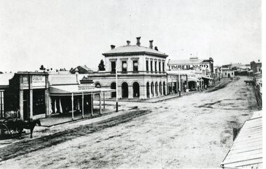
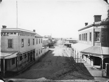
Photograph, Main Street & Patrick Streets corner looking East down Patrick Street with the Foresters Hotel on left corner 1878
First floor view from corner of Main & Patrick Streets looking East down Patrick Street. Weatherboard Foresters Hotel in Main Street on left corner. Foresters Hotel was built in 1868 by Mr. Joseph Cawley, Mr. and Mrs. Cawley were the occupants for 30 years. The site was previously occupied by a Billiards Room. In 1917 the building became Foresters Coffee Palace with new owner Mr. J.C. Crothers who purchased the building for 410 pounds and leased it to Mr. Robert Wennerbom. The next lease holder was Miss Fulton and in 1921 Mrs. R. Claringbold took over and called the building Foresters House. The building was sold in 1935 and demolished shortly after sale. Businesses visible down Patrick street, Foresters Hotel, J.H. Wallis Royal Exchange Hotel on Big Hillside of Street. With St Patrick's church tower visible in distance. Melbourne Cash Store Wines and Spirits on corner of Patrick and Sloane Street near centre of photo. Ferns Hotel / Times office on right of photo, corner of Patrick and Main Street. Post Box on Corner at right of photo. 1878First floor view from Main Street Patrick Street intersection looking down Patrick Street. Foresters Hotel on left. Fern Boarding House on right.Victorian Views. C. Herbert, Photo. Stawell 1878stawell businesses streetscape -
 Eltham District Historical Society Inc
Work on paper - Folio, Register of Significant Trees, Shire of Eltham, c.1993
... and Environment Office (former police quarters) Main Road Eltham Former... and Environment Office (former police quarters) Main Road Eltham Former ...In 1983, the National Trust advised the Shire of Eltham that it was investigating a number of trees within the shire which had been nominated for recording the Register of Significant Trees of Victoria. The trees involved were described in the Shire of Eltham Historical Society Newsletter No. 29, March 1983 as follows:- 1. Eucalyptus melliadora (Yellow box) . a) An outstanding mature specimen 42 metres high in Laughing Waters Road, Eltham. b) Another mature specimen in Arthurs Creek road, Hurstbridge is reported to be the tree under which the bushranger Robert Bourke was tied after he shot and killed Henry Hurst in 1866 . 2. Quercus robur (English Oak). a) "Donaldson's Oak", Donaldsons Road, Kangaroo Ground was planted by John Donaldson from seed collected from Windsor Great Park in 1878. b) "Wippells Oak". This now misshapen tree is located on the St. Andrews Road near the Kangaroo Ground Fire Station. Its origins may have been similar to Donaldson's Oak, and as a young tree it apparently slipped from higher up the hill during wet weather. Both oaks are of local historical importance. 3. Eucalyptus globulus (Blue Gum). A large mature specimen at the corner of the Kangaroo Ground-St. Andrews Road and Bakehouse Road, Panton Hill. 4. Plantanas acerifolia (Plane tree) A number of trees forming the Avenue of Honour to Eltham's First World War soldiers along Main Road between Dalton and Pitt Streets, Eltham. 5. Pinus canariensis (Canary Island Pine), Pinus pinea, (Stone pine) and Cedras altlantica, (Cedar) These trees are located at the Hurst family graves in the grounds of the Hurstbridge Pre-school Centre. In 1991 the Shire of Eltham introduced controls into its planning scheme to protect sites of architectural, historic or conservation interest and significant trees. The controls were approved by the Minister for Planning and Housing. As advised in the Shire of Eltham Historical Society Newsletter No. 78, May 1991, a planning permit is required to demolish or alter any listed building or to destroy, lop or remove any listed tree. Provision is made for comments to be obtained from the National Trust or Historic Buildings Council in considering any applications. The buildings and trees listed were: Buildings: 250 Bolton Street Eltham (former Walter Withers home) "Rosehill" - Bonds Road Lower Plenty St Andrews Church of England - St Andrews "Montsalvat" - Hillcrest Avenue Eltham St Margarets Church and former vicarage - Pitt Street Eltham Presbyterian Church - Kangaroo Ground Parks and Environment Office (former police quarters) Main Road Eltham Former Court House - Main Road Eltham "Shillinglaw Cottage" - Main Road Eltham "The Robins" - Kangaroo Ground Road Warrandyte Trees: "Donaldsons Oak" - Donaldsons Road Kangaroo Ground Yellow Box - Laughing Waters Road Eltham Yellow Box - Arthurs Creek Road Hurstbridge Wippells Oak - St Andrews Road Kanqaroo Road Pines and Cedar - Hurst family cemetery Greysharps Road Hurstbridge Yellow Box - Parsons Road Eltham A large Blue Gum at Panton Hill has been listed but has recently died (1991). In 1993 work by Council Parks and Environment staff and volunteers resulted in the preparation of a Significant Tree Register listing forty-one trees or groups of trees. According to Shire of Eltham Historical Society Newsletter No. 91, March 1993, a similar number remained to be assessed for inclusion in the register. There is a wide range of indigenous and planted trees on private and public land and extending through the Shire of Eltham from Lower Plenty to Kinglake. Most can be viewed from publicly accessible locations. The Significant Tree Register lists 41 trees or groups of trees throughout the Shire. It contains a wide range of naturally occurring and planted trees. They have been assessed according to eleven criteria including size, age, rarity, historical value and the like. The list includes large old Red Gums at Lower Plenty, historic Oaks at Kangaroo Ground and Mountain Ash at Kinglake. The register includes a set of slides showing each tree. Garry Bartlett of the Council's Parks and Environment Section and Faye Shepherd were extensively involved in establishment of the register (Newsletter No. 93, November 1993). In 1999 Niliumbik planners prepared an amendment to the Planning Scheme to provide protection for approximately 200 of the places listed in the heritage studies and also in the Significant Tree Register commenced by the Eltham Council (Eltham District Historical Society Newsletter No. 127, July 1999. In 2004, The Register of Significant Trees was presented to the Eltham District Historical Society by Nillumbik Shire Council as part of a wider collection of of its memorabilia of the former Eltham Shire Council (EDHS Newsletter No. 159, July 2004. Album of loose handmade paper sheets contained within a handmade slip cover constructed of handcrafted card with encapsulated flora material (flowers, vines, ferns) and tinted. Each page also contains an embedded/adhered fern leaf also tinted with lacqueur or similar, text as appropriate in ink by hand calligraphy. Each page also has a white protective sheet cut to size and adhered to back surface with sticky tape and folded over face of page. Pages variously have photographs and coloured masks adhered with a gum resin. Over time much of this resin has let go and photos/masks have been reattached using acid free archival safe adhesive. 15 pages 41 x 29 cm inclusive of 3 blank pages. Slip case 42 x 30 x 1 cm; face cover of slip case has broken off at left hand margin as insufficient depth/flexibility for contents.arthurs creek road, blue gum (eucalyptus globulus), canary island pine (pinus canariensis), couties road, donaldsons oak, donaldsons road, eltham, english oak (quercus robur), eucalyptus melliodora, graysharps road, hurst tree, hurstbridge, ironbark (eucalyptus tricarpa), ironbark hill, kangaroo ground, kangaroo ground-kinglake road, laughing waters road, panton hill hotel, panton hill, parsons road, significant trees register, sonia van bodegraven, sonjart, stone pine (pinus pinea). atlantic cedar (cedrus atlantica), wippells oak, yellow box gum (eucalyptus melliodora), yellow box gum