Showing 2791 items
matching country victoria
-
 Kiewa Valley Historical Society
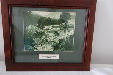
Set of 6 framed photographs - Kiewa Hydro Electric Scheme
Official photos - Kiewa Hydro Electric Scheme constructed by State Electricity Commission of VictoriaOfficial photos of KHES in the Kiewa Valley1. Junction Dam Excavation - 5th April 1941 2. Bogong Residential Area Development - 24th April 1940 3. Beginning of Mt Beauty Township - 20th February 1947 4.Pretty Valley Bridge - 9th September 1940 5. Junction Dam - General View from Downstream - 15th September 1943 6. Construction of Dam Wall for Rocky Valley Dam - 1958khes, secv -
 Kiewa Valley Historical Society
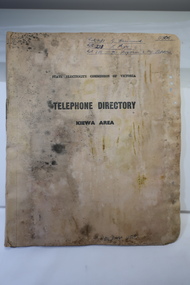
Book - Telephone Directory of the Kiewa Area, State Electricity Commission of Victoria -Telephone Directory - Kiewa Area
The State Electricity Commission produced a Telephone directory for each of its construction sites during the construction of the Kiewa Hydro Electric Scheme during the 1950s to early 1960s. The telephones were linked via the Switchboard. The booklet includes instructions for operating.The SECV constructed the KHES during the 1950s. It included construction sites on the Bogong High Plains and the townships of Bogong and Mt Beauty. It also connected the Scheme with the outside world and was operated through the switchboard which was located in Mt Beauty. This booklet also gives names of staff and some workmen - their occupation and their whereabouts of work at the time. Cardboard cover with pages inside bound by metal clasp. Pages divided with tabbed headings:- Bogong, Mt Beauty, West Kiewa, McKay Creek Howmans, Rocky Valley Langford's Gaptelephone directory kiewa hydro electric scheme, kiewa hydro electric scheme telephones -
 Kiewa Valley Historical Society
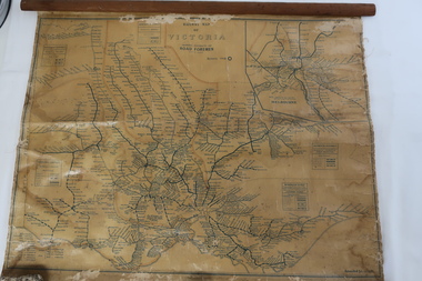
Map - Railway Map of Victoria, Amended to 1/11/1945
Railways began in the 1850s and were privately owned and operated. Later they were taken over by the Victorian Government reaching a peak in the early 1940s.Steam trains were followed by electric trains with both running after the war in 1945.Bright was the closest station to the Kiewa Valley but road transport was used more often as the Kiewa Valley Highway was improved with the construction of the Kiewa Hydro Electric Scheme. To travel to Melbourne or Sydney by train residents went via Wodonga/Albury where they also did their shopping.Plastic on parchment with detailed railway routes (in green) across Victoria including each district's 'Road Foremen' and 'Depots'. There is a length of flat wood attached by 10 tacks across the top of the mapvictorian railways 1945, trains, transport -
 Kiewa Valley Historical Society
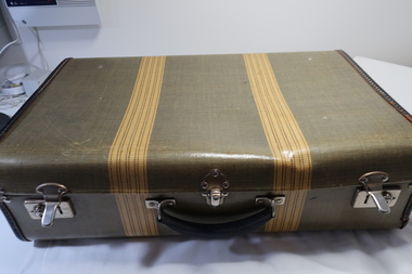
Case with Books x9 - 1930s to 1950s, 1. The Lawsons by Gwen Meredith 2. A Many Splendoured (sic) Thing by Han Suyin 3. Reach for the Sky by Paul Brickhill 4. My Fair Lady 5. Brownies at St. Bride's by Ethel Talbot 6. The Children's Treasure House 7. Complete Household Guide 8. The Royal Tour of Australia and New Zealand in Pictures 9. Under Southern Skies Victoria ..Australia
These books are all old and belonged to local families in the Kiewa Valley. Reading was a major form of entertainment from the 1930s before TV was available.These books give an insight into the interests of families in the Kiewa Valley prior to the invention of TV.Case - Stiff cardboard, yellow & green with two yellow strips on outside. Inside blue squares. Metal handle attached. Fastened by two sliding locks one at each end and each with a key hole. There is a clip/clasp in the front centre. Books: Nos. 1-4 A collection of x4 medium size novels belonging to Vera Hore; No. 5 x1 belonging to Jessie Hollonds, Tawonga and is a small book with coloured cover. No. 6. large red book No. 7. a large yellow/brown book No 8. a large hard covered red book with x2 gold lions on front No 9. colored cardboard cover with spiral spineCase - Label on the lid inside and centre top: 'Made by/ Permacase/Melbourne, Victoria/Aero Tweed Books: 1-4 Mrs Vera Hore / Bogong Hotel / Tawonga inscribed on front page 5. Lois Jessie Hollonds, Tawonga "To dear Lois / With best wishes / from Nancy / Xmas 1934 inscribed on front page 6. Dorothy Maureen Ryder / Tawonga / 1-10-35 inscribed on front page 7- - 9. nilhore family tawonga hotel, hollonds family, old books, royal tour 1950s -
 Kiewa Valley Historical Society
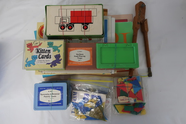
Educational Aids - Primary
Mt Beauty Primary School commenced in 1948. At the time the Educational Aids / games were up to date and plentiful in the Primary grades. Educational aids continue to be updated along with technology.Mt Beauty Primary School began with up to date equipment and teaching methods. This collection is an example of pre-computer equipment.Variety of educational games and aids including those for teaching Italian 1. La Tombola del flori 2. Ecco Pinocchio - illustrated by Edward Dyas 3. Children's Italian Dictionary by Franko Leoni 4. La Befana- Notes for Teachers - Produced by the Catholic Education Office of Victoria 5. Italy a brief outline 6. Orizzonti - April Edition 1995 7. Zucchero filato - illustrated by Edward Dyas 8. La tombola dei negozi 9.Variform Inset Placing Trays Set 1- Philograph Publications 10. Cubes for matching 11. Kitten Cards - A Child's Play Quartet 12. Symmetry & Reversal Pairing Cards Boxes 1,2 & 3 Philograph Publications 13. Picture Dominoes - Hoborn Productions 1980 14. Figura Shapes 15. Colour and Lay Shapes 16. Tessellations 17. Tangram x2 18. Compass - Mathematical instrument -wooden, large size to fit drawing a circle with chalk on a blackboardmt beauty primary school, educational game and aids -
 Kiewa Valley Historical Society
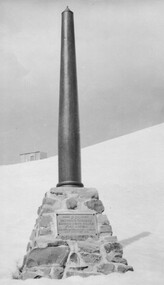
Photo: Memorial on the Staircase Spur Track, Mt Bogong
Mt Bogong is the highest mountain in Victoria. The Staircase Spur track to its top starts at Mountain Creek Road going through forest and continuing above the snow line to grass land. The weather can change very quickly with cloud and snow making conditions dangerous. Large sepia photo of the Memorial in snow on the Staircase Spur Track on Mt Bogong. The Memorial has a plaque attached: Sacred to the Memory / of Georgine Gadsden / Edward Neave Welch / John McRae / who perished here during a blizzard / about August 2nd 1943staircase spur memorial, mt bogong -
 Kiewa Valley Historical Society
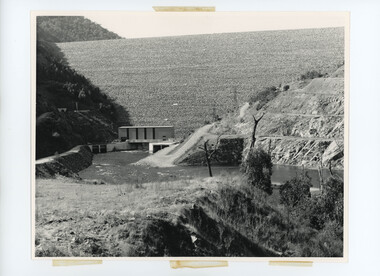
Photos - Kiewa Hydro Electric Scheme - Dartmouth, Official S.E.C.V. photos
Dartmouth Dam was built on the Mitta Mitta River in the 1970s. It is the highest dam in Australia (2022). It is the largest storage in Victoria (2022). It was built primarly for irrigation and urban use. The power station has the largest hydro-electric generator in Victoria (2022). -
 Kiewa Valley Historical Society
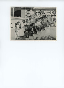
Photo - L.T.A.V. A-Grade Premiers
Black and white poto of a large group of people with a 'Premiers flag, A Grade, LTAV - Lawn Tennis Association of Victoria' -
 Kiewa Valley Historical Society
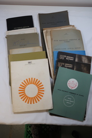
SECV including Annual Reports 1940s - 1970s
SECV built KHES15 thick Booklets mostly Foolscap bound by staples 2 Royal Commission on Electricity Supply Answers to set of questions April 1947 1 SECV black hard cover book 'Acts' 1958 1 'SEC History in the Making - Golden Jubilee Photo feature - thin 8 page booklet.state electricity commission of victoria -
 Kiewa Valley Historical Society
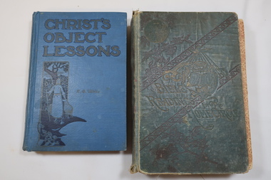
Books and Certificates - Baker Family
History and Beliefs of Jehovah's Witness Religious OrganisationThe Baker family lived in the Kiewa Valley. Their herd of 15 cows yielded an average of 5614 lbs. Milk 5.2% average test and 301.71 lbs. Butterfat in 273 days with allowances for junior cows in the year 1930-31 1. Book - 'Bible Readings for Home Circle' 1906 2. Book - 'Christ's Object Lessons' 3. 8 small folded papers each with a religious message 4. Certificate to Mr J. Baker presented by the Royal Agricultural Society of Victoria re Dairy Herd in Oct. 1931 5. Certificate to L.A.C.I. G. Baker 49th Optl. Based Unit R.A.A.F. Shire of Yackandandah Feb. 1946baker family, kiewa valley, jehovah's witness, dairy farming -
 Kiewa Valley Historical Society
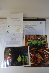
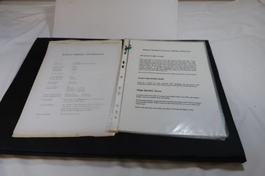
AGL - Bogong Information Centre
AGL took over the operation of the Kiewa Hydro Electric Scheme and constructed the 'Bogong Power Development Project. This involved the construction of a new underground Hydro Electric Power Station on AGL Hydro's Junction Dam regulating pondage near Bogong village in Vctoria's High country. Construction commenced in 2007 and was completed by the end of 2009The Bogong Power Development Project was important to Victoria as hydro power was environmentally friendly. It was important to convey this to the population by way of educating them on the understanding of how it worked and its benefits to providing power to Victoria and beyond.Collection of photos, folders and papers used at the Bogong Information Centre to inform the public on the operation of the Kiewa Hydro Electric Scheme. Dated 2007 - 2009bogong power development project, agl hydro at bogong -
 Kiewa Valley Historical Society
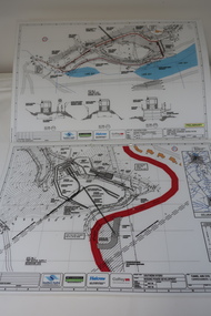
Plans - Southern Hydro - Bogong Power Development
Southern Hydro owned the Kiewa Hydro Electric Scheme in May 2006 when these plans were created. The Site No. 1 and Site No. 2 are part of the Bogong Power Development Bogong Power Development is part of the Kiewa Hydro Electric SchemeLaminated A3 plans mostly black and white but with a little color and surrounded by a grid.(Also see KVHS 1439) 1. Tunnel and Civil works / Commissioners Lodge Site Plan 1: Site No. 1 / TBN /Water /Supply / Reservoir Site 2. Tunnel and Civil Works / Pedestrian Diversion Access Paths / and Tracks: Site No. 2 / Lake Guy Site / Bogong Victoriabogong power development, southern hydro 2006 -
 Kiewa Valley Historical Society
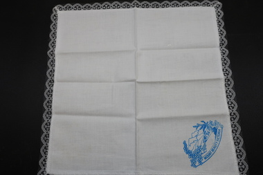
Hankerchief
Mount Beauty is a tourist destination and this 'hanky' may have been a souvenir.Since the completion of the Kiewa Hydro Electric Scheme Mount Beauty has become a tourist destination. The 'hanky' depicts the snow on the mountains and nature as an advertisement for visiting the town and its surrounds.White cotton handkerchief with lace edges and a blue print in one corner. The blue print is a picture of mountains with snow and with wattle trees in the foreground and with the words Mount Beauty Victoria.mount beauty tourism, handkerchief -
 Kiewa Valley Historical Society
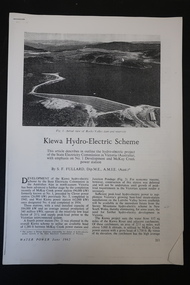
Papers - Kiewa Hydro Electric Scheme
Kiewa Hydro Electric Scheme constructed by the SECV and completed in 1961The SECV constructed the KHES from the late 1940s to 1961 in north east Victoria9 black & white pages numbered 213 to 221 held together by a staple in the top left hand corner. Photocopied from 'Water Power June 1962'kiewa hydro electric scheme, water power 1962 -
 Kiewa Valley Historical Society
Folder - Falls Creek
Falls Creek Snow Resort is on the Bogong High Plains in north east Victoria. It competes with other Australian snow resorts during Winter. This folder was created in the 1990s.Falls Creek began during the construction of the Kiewa Hydro Electric Scheme. It is a major ski resort in Australia and is currently promoting tourism in Summer especially for bush walkers and cyclists.Red plastic folder with 6 pages in plastic sleeves. Each page has headings describing and promoting the facilities and benefits of Falls Creek Snow Resort.falls creek snow resort, tourism in alpine resorts -
 Kiewa Valley Historical Society
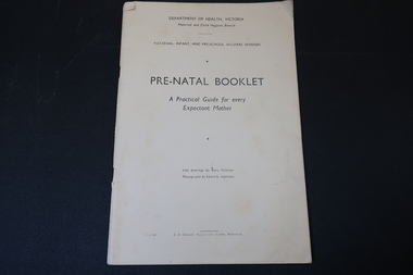
Booklet - Pre-natal, Pre-Natal Booklet - A Practical Guide for every Expectant Mother by Department of Health Victoria
The Maternal, Infant, and Pre-school Welfare division of the Victorian Health Department published this booklet to assist expectant mothers with information regarding their confinement.Pre-natal information was important for expectant mothers especially those living in isolation eg. the farming community in the Kiewa Valley.Cream coloured booklet with 65 pages held by 2 staples. It has 10 chapters on pre-natal and 4 chapters on post natal. It is very comprehensive with a few black & white illustrations. There is an 'Obstetric Table' on page 5 "To calculate the date of confinement." It was produced by the Maternal, Infant, and Pre-School Welfare Division. prenatal, victorian health department -
 Kiewa Valley Historical Society
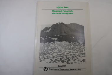
Book - Book - Alpine Area - Department of Conservation, Forests & Lands, Alpine Area / Planning Proposals / a basis for management. 1987
It is the policy of the Government that most of the State's alpine area will be proclaimed as an Alpine National Park, which would complement the Kosciusko National Park in N.S.W.. This is yet to be achieved (1987), however there is a need for sound, efficient and coordinated management based on the area's natural features, values and uses. Planning is proceeding on this basis.Victoria's alpine area is one of the State's most outstanding and spectacular natural areas. It is noted for its diverse plant and animal life, scenery, recreation opportunities and as a water catchment. This country is at the upper end of the Kiewa Valley and the planning for it is of interest to the Kiewa Valley inhabitants.White bound book with green print for title at the top, black & white picture and black print at the bottom for the name of the government authority publishing the book.143 pages with fold out map after page 7. The map is coloured green to indicate the planning area.alpine area, bogong national park, victorian department of conservation forests & lands -
 Kiewa Valley Historical Society
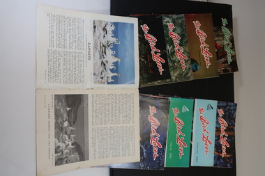
Magazines - "The Bird Lover" 1960 - 1968, The Gould League of Bird Lovers of Victoria Volumes XIII to XXI
The Gould League is an independent not-for-profit organisation celebrating 100+ years of environmental and sustainability education. Formed in 1909 and set up to prevent bird egg collecting and to educate for the protection of Australian birds,School children in the Kiewa Valley belonged to the Gould League of Victoria and were educated in not only the conservation of but also the identification and habits of bird species in the area and beyond.9 soft coloured cover magazines of 31 pages held by 2 staples. Each includes coloured and black and white photos.australian birds, gould league of victoria, bird lovers -
 Ringwood and District Historical Society
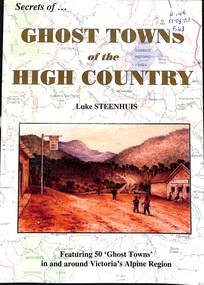
Book, Secrets of Ghost Towns of the High Country
Featuring 50 "Ghost Towns" in and around Victoria's Alphine Region -
 Ringwood and District Historical Society
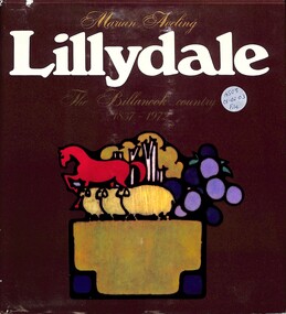
Book, Lillydale - The Billanook Country 1837-1972
Hardcover book outlining the earlier history of the Shire of Lillydale (Victoria). -
 Ringwood and District Historical Society
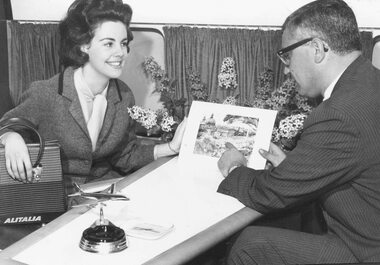
Photograph, Sue Bennett of North Ringwood, Victoria's "Girl of the Year" (undated)
Typed on back of photograph P121(a), "Sue Bennett, Victoria's "Girl of the Year" pictured boarding an Alitalia aircraft at Sydney Airport on the first stage of her trip around the world. Sue, 19, of Warrandyte Road, North Ringwood, will visit twenty countries in the course of the next few weeks and will be interviewed on radio and television in Europe and the United States. She will spend ten days in Rome and will also visit Naples, Venice, and Milan, and other parts of Europe before going to London and the United States." Stamp also on back of photograph reads, "John A. Mulligan, Photographer, 108 Albion St. City". No inscription on the back of P121(b) but stamp states photographer as, "Stuart Goldsworthy, ... Melbourne". -
 Orbost & District Historical Society
black and white photographs, 1934
These photographs were taken just after the McKillop's Bridge was completed after the flood damage. The current McKillop’s Bridge was built by the Country Roads Board in two stages between 1931-36, during which its height was raised after the original bridge superstructure was washed away in record floods of January 1934, prior to its original official opening. In its reconstructed form the original concrete abutments were turned into additional piers and the welded-steel trusses were cantilevered back over them to meet the new higher road approaches. It is sited at McKillops Crossing, named after pioneer overlanding squatter George McKillop who crossed here in 1835. This was a stock crossing place for almost a century before the bridge was constructed. (info. from Victoria Heritage Register)This is a pictorial record of the history of McKillop's Bridge, in itself of historical significance for its association with Victoria's long and important pastoral history, its technicl significance and aesthetic significance.Three black / white photographs. 3133.1 shows the approach to a washed away bridge. 3133.2 is of a bridge over a river with men clearing debris. 3133.3 is a close-up showing the wreckage of the bridge.mckillop's-bridge snowy-river flood-damage-1934 -
 Orbost & District Historical Society
black and white photograph, C1909
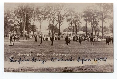
The celebration of Queen Victoria's birthday on May 24 was renamed Empire Day in 1903 after her death in 1901. It was celebrated throughout the British Empire culminating in fireworks and bonfires in the evening. Empire Day was first introduced in 1905 to promote loyalty among the dominion countries of the British Empire. (from https://dictionaryofsydney.org/event/empire_day) Celebrated on 24 May, Queen Victoria's birthday, it was directed especially at school children. Teachers were encouraged to promote special steps to develop a feeling of pride in the British Empire and the achievements of the British race. Often a morning of short addresses, recitations and patriotic songs such as 'Rule Britannia' and 'Advance Australia' was followed by a half-day holiday to mark the celebration of Australia's strong ties to the British Empire. (from MuseumsVictoria)Empire Day was a celebration of the British Empire that was held for many years in the United Kingdom, Australia, Canada, and other countries. It took place every year on May 24, the date of Queen Victoria's birthday. Queen Victoria ruled England for 63 years. this item reflects the loyalty to and recognition of the British royal family in the first half of the 20th century.A black / white photograph of a large group of people , men in suits, women in long dresses. They are in a large fenced clearing.on back -" EMPIRE DAY ORBOST before 1909"empire-day celebrations gatherings public-events -
 Orbost & District Historical Society
May 1900
This is a photograph of the original Orbost / Snowy River Bridge , a suspension bridge which opened in 1893. It has been taken when the Snowy River was in flood. It is similar to other photographs held in The State Library, Victoria. The Snowy River Mail and Tambo and Croajingolong Gazette Sat 12 Aug 1893 records the opening of this bridge as "the most important public event that has yet been commemorated in Eastern ......The Messrs McLeod, with whom the first settlement of this district is generally associated, took up their residence on the eastern bank of the Snowy River about the year 1841 or 42. The late Mr W. Roadknight and Mr T. T. Stirling took possession of the territory on the western side of the Snowy about 35 years ago. During the occupation of the country by cattle owners, very little progress was made in the way of roads and bridges, and except to the hardy and lexperienced bushman, it might have been generally regarded as inaccessible. About the year 1877, however, the late Mr James Robertson eldest son of Mr James Robertson, of Lochend farm, selected land now occupied by his father, about four miles from Orbost on the west bank of the river, Mr John Cameron visited the. district shortly after a .tour of inspection and returned later with his brothers, James and Alick Gameron, but found that during their absence Mr Ernest Watt had found his way on the scene and pegged out a selection, thus anticipating the advent of the Camerons by about 12 hours. We understand that a Mr Kidd, who selected the property now occupied by Mr W. J. Ross, at Pumpkin Point, was one of the earliest batch of settlors.........."This is a pictorial record of an early bridge across the Snowy River at Orbost.A black / white photograph of a suspension bridge with flood waters below the bridge.orbost-bridge suspension-bridge snowy-river -
 Orbost & District Historical Society
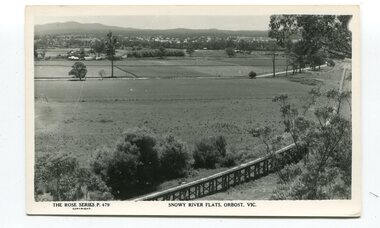
black and white postards, Rose Stereograph Company, 1940s -1950s
These postcards are part of the Rose series of photograph / postcards taken around Victoria. Rose was born in Clunes in 1861 and later worked in his father’s boot-making business in Prahran while studying photography. In 1880 he founded the Rose Stereograph Company and became famous for producing stereographs, or stereoviews, which gave the illusion of being in 3D when seen through a hand-held viewer, a big craze of the era. Rose produced stereoviews of the Western Front during the First World War. In all, he took about 9000 images in about 38 countries. As stereographs lost popularity in the 1920s, Rose switched to production of postcards and decorative cards, and he and the photographers who followed took thousands of scenes around Victoria as well as interstate that became iconic images of Australian life.These postcards are pictorial records of Orbost in the mid 20th century.Postcards such as these were a way of showing the scenic attractions of Orbost to potential tourists.Three black / white postcards of views over the Orbost flats and railway viaduct. 3183.1 is of a railway viaduct in the foreground and farming flats. 3183.2 is a view over the Orbost flats taken from Grandview Lookout. 3183.3 is a view from the Grandview Lookout showing the back of a woman looking across a rail fence. 3183.1 - bottom front - Rose Series P 478 SNOWY RIVER FLATS, ORBOST VIC 3183.2 - bottom front - Rose Series P 49 ORBOST, FROM GRANDVIEW HEIGHTS,VIC 3183.3 - bottom front - Rose Series P 14443 A VIEW FROM THE LOOKOUT, ORBOST, VICpostcards-orbost rose-series orbost-railway-viaduct grandview-lookout-orbost -
 Orbost & District Historical Society
black and photograph / postcard, 1.4.1908
This postcard was sent to Annie Gilbert (Mrs John Gilbert) of Tullagoota, Orbost. It was written by "Grace", probably her sister, Grace Cameron Annie Gilbert was the daughter of John Cameron who selected the first land on the Snowy River flats. This is a photograph of the original Orbost / Snowy River Bridge , a suspension bridge which opened in 1893. It has been taken when the Snowy River was in flood. It is similar to other photographs held in The State Library, Victoria. The Snowy River Mail and Tambo and Croajingolong Gazette Sat 12 Aug 1893 records the opening of this bridge as "the most important public event that has yet been commemorated in Eastern ......The Messrs McLeod, with whom the first settlement of this district is generally associated, took up their residence on the eastern bank of the Snowy River about the year 1841 or 42. The late Mr W. Roadknight and Mr T. T. Stirling took possession of the territory on the western side of the Snowy about 35 years ago. During the occupation of the country by cattle owners, very little progress was made in the way of roads and bridges, and except to the hardy and lexperienced bushman, it might have been generally regarded as inaccessible. About the year 1877, however, the late Mr James Robertson eldest son of Mr James Robertson, of Lochend farm, selected land now occupied by his father, about four miles from Orbost on the west bank of the river, Mr John Cameron visited the. district shortly after a .tour of inspection and returned later with his brothers, James and Alick Gameron, but found that during their absence Mr Ernest Watt had found his way on the scene and pegged out a selection, thus anticipating the advent of the Camerons by about 12 hours. We understand that a Mr Kidd, who selected the property now occupied by Mr W. J. Ross, at Pumpkin Point, was one of the earliest batch of settlers.........."This item is associated with Annie Gilbert (nee Cameron) reported to have been the first white girl to be born in Orbost. It is a pictorial record of the suspension bridge over the Snowy River which has since been replaced twice.A faded black / white postcard of a bridge across a river. There are cattle in the river and the banks are tree-covered.on back - a hand-written letter addressed to Mrs J. Gilbert Tullagoota Orbost.cameron-annie suspension-bridge-orbost snowy-river-orbost -
 Orbost & District Historical Society
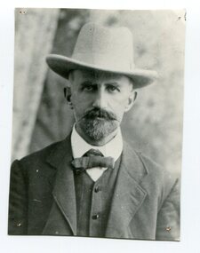
black and white photograph, first half 20th century
This is a photograph of Nathan Spielvogel.. Nathan Frederick Spielvogel (1874-1956), teacher, writer and historian, was born on 10 May 1874 at Ballarat, Victoria. as well as his stories he published a number of Books about the history of Ballarat. Spielvogel taught at Orbost for at least a year and this book reflects that time. Spielvogel was a teacher, writer and historian. As a country schoolteacher, he traveled widely in the eastern Australian outback and also made a journey to London. Spielvogel gained distinction as one of the only Australian Jewish writers of his time. Many of his early books were best-sellers. He has an association with the history of Orbost having spent a year as a teacher at Orbost Spielvogel was a teacher, writer and historian. As a country schoolteacher, he traveled widely in the eastern Australian outback and also made a journey to London. Spielvogel gained distinction as one of the only Australian Jewish writers of his time. Many of his early books were best-sellers. He has an association with the history of Orbost having spent a year as a teacher at Orbost.A black / white portrait photograph, head and shoulders, of a man with a goatee beard and moustache and wearing a large hat. he is wearing a buttoned waistcoat, jacket and bow tie.spielvogel-nathan author-spielvogel -
 Orbost & District Historical Society
black and white photograph, 1913
This photograph shows Country Roads Board men clearing a bush track at Hospital Creek. Their vehicle was bogged. The y Roads Board was formed in 1913 1910 it had become apparent that there was a need for a central roads authority to take over responsibility from the Board of Lands and Works for the care and management of the main roads of the state of Victoria. Because there was no consistent and systematic policy for road maintenance Victorian roads were in a deplorable condition. At this time the use of the motor car accentuated the demands for better roads. As a result of these needs the Country Roads Act 1912 was proclaimed in 1913 providing for the establishment of the Country Roads Board as a central road authority with responsibility for those roads within the State considered to be main roads. the C.R.B. was responsible for the construction of roads and bridges including the Snowy River road bridges in Orbost.. This is a pictorial record of transport difficulties in East Gippsland in early 20th century.A large black / white photograph of three men clearing a bush track with a motor vehicle behind them.transport roads road-maintenance country-roads-board -
 Orbost & District Historical Society
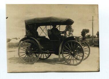
black and white photograph, 1910
Alan Richardson was born in 1853 and died in 1936. He was a sawmiller at Tabbara who built and held the ticket for the Paddle Steamer Curlip. PS Curlip was registered in 1893 and the Passenger Certificate issued on 30th January 1903 to Captain Alan Richardson by the Marine Board of Victoria entitled her to carry 25 passengers and only 10 passengers when engaged in towage service. Two children under 12 years of age to be reckoned as one passenger. He had the first horseless motor buggy in Orbost. Alan Richardson was married to Emily Dawson and had two children - Alan Jnr and Ruth.Before the First World War, few people in Australia owned or knew how to drive cars before they bought them. This International auto buggy was promoted as a useful vehicle for station owners, farmers, doctors, and town and country salesmen. It was said to be the cheapest automobile in Australia (at one third the cost of a conventional car), required much less maintenance, had durable solid rubber tyres rather than troublesome pneumatic ones, and didn’t need a chauffeur. This is a pictorial record of a "horseless buggy" which would have been a novelty in the early 20th century in Orbost. The item is associated with the Richardson family, early Orbost settlers.A small black / white photograph of a motor vehicle with a man seated at the steering wheel. The vehicle has large buggy wheels with mud guards. It is open with no windows.transport motor-vehicle horseless-buggy richardson-alan -
 Orbost & District Historical Society
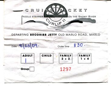
ticket, 8.03.2009
This is a ticket for one adult to cruise on the P.S.Curlip 11 which operated from the Brodribb Jetty in Marlo.from 2007 - 2015. "Paddle Steamer Curlip, a 62 feet long, traditional, plank on frame carved timber vessel, that was built by the people of East Gippsland at Orbost, in far Eastern Victoria. The undertaking to design and build this vessel, as a community project commenced in 2002. The community, based around Orbost was largely dependant on the Timber industry in the surrounding Victorian High Country. With the closure of Alpine logging and the creation of vast National Parks, the people of the region needed to create a major undertaking to bond the community and engender… a sense of belonging, this was critical for many of the men, who were dispossessed with the loss of their historical timber and forestry industry." (Information from website: https://www.curlip.com.au/) The Paddle Steamer Curlip 11 is a reproduction of the historic Curlip a small paddle steamer built by Samuel Richardson and his sons at his Tabbara sawmill near Orbost. It helped open up the region in the 1880’s before road or rail, serviced East Gippsland. Much work is being done to restore the Curlip 11 so that it can begin again as a tourist cruise boat.The P.S.Curlip 11 is Victoria's only Paddle Steamer. It was a community project involving many Orbost peolpe.A rectangular, white paper ticket with black print. In red is No. 1297 and the date and cruise time are hand-written in blue pen. ttached to the back of the ticket is a printed receipt.paddle-steamer-curlip 11 tourism-orbost