Showing 1645 items
matching settlements
-
 Melton City Libraries
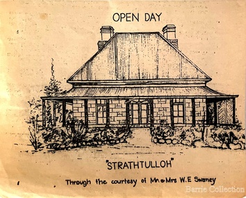
Drawing, Open Day at Strathtulloh, Unknown
"Strathtulloh, 1402-1600 Greigs Road, Melton South, is significant as an early property in Victoria, retaining different eras of pioneering dwellings, ranging from a ruin to a fine Colonial style homestead. The property has close historical association with the early settlement of the Melton district, and was owned by the Henty family in the 1840s. The Strathtulloh property was alienated by the Crown in 1840 to Charles James Garrard, who sold it in 1848 to Charles and Stephen Henty, whose sister Jane and her husband Samuel Bryan lived there in the late 1840s. In 1853 the property then passed to William Tulloh, after whom the homestead was named. A primitive bluestone ruin of near the Toolern Creek, built of vesicular bluestone and mud mortar, is of unknown origin. It has commonly been assumed to pre-date 1840, and to have belonged to the original holder of the Exford lease, Dr Watton or Port Phillip Association member Dr Cotterill. This is unlikely, as the 1841 census records Dr Watton, and everyone else in the district, as living in a ‘wood’ dwelling. It may instead have been the residence of Garrard, and the Bryans, in the 1840s and an early map names a site near here as ‘Bryan’s outstation’. It is assumed that the two-level stone building that became the kitchen is the earliest intact building on the site, and was the first homestead; it is likely to date to the 1840s or 1850s. The main homestead is a substantial villa constructed of random coursed bluestone, with a verandah facing three sides, attic bedrooms with dormer windows, a fan light over the front door, a hipped roof originally clad in slate, and a large cellar. Although demonstrating characteristics of pioneering construction, such as unworked log beams, pit sawn beams, hand-sawn lintels and colonial door locks, documentary evidence shows that it was built c.1869. The homestead has now been structurally repaired and decoratively restored; a sympathetic new semi-detached rear extension was added in the early years of the 21st century. The former kitchen building has also undergone minor repairs and alterations". Strathtulloh Homestead at 1402-1600 Greigs Road, Melton Southlocal architecture -
 Eltham District Historical Society Inc
Photograph, The Australasian, Eltham - A series of four scenes of the local district, 2 May 1903
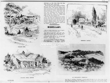
Australasian (Melbourne, Vic. : 1864 - 1946), Saturday 2 May 1903, page 25 ________________________________________ ELTHAM A POPULAR HOLIDAY SPOT. By L.J.J. The village of Eltham, with its 377 in habitants, is prettily situated on Diamond Creek, a tributary of the Yarra, 16 miles from Melbourne. Yet, in spite of it being so easily accessible from town, few people are aware of the beauties of this early settlement. Prior to June last year one had to journey by coach from Heidelberg to Eltham, but now the railway conveys passengers through from Melbourne to Eltham, first-class return, for 1/9. The opening of this extension to Eltham was the last ceremony performed by Lord Hopetoun, on June 5, 1902, prior to his departure from Australia. Sauntering through the township one autumn morning recently I was constantly reminded of scenes characteristic of Surrey or Sussex villages. There is the village pond (so essentially English), reflecting in its clear water a quaint cottage, dwarfed by a huge gum tree, an old smithy, and a hostelry, built quite fifty years ago, the flooring-boards of which the landlord informed me with pride were of Singapore cedar, and quite fit for another fifty years' wear. Then there are the village school, the shoemaker's, the drapery store, and the butcher's shop, all seemingly as they were when first they were erected many years ago. Poplars grow to a great height at Eltham, and just now they are to be seen in rich autumnal tints. The already leafless fruit trees on the slopes of the creek denote the near approach of winter. Orchardists were taking advantage of the recent rains, and were busy ploughing and harrowing between the trees, while the magpies and other birds were picking up worms and grubs on the newly-turned soil. The busy time for Eltham is the holiday season, and then the inhabitants are put to their wits' ends to provide for the rush of picnic parties, cyclists, and other excursionists. Outside almost every cottage is a notice stating that "summer drinks and hot water" are obtainable. Sketches illustrating the article: VILLAGE POND. DRAPERY STORE, ELTHAM. ON DIAMOND CREEK. HOSTELRY, ELTHAM. AN ORCHADIST'S HOMESTEAD. ON THE HEIDELBERG-ROAD IN AND AROUND ELTHAM.This photo forms part of a collection of photographs gathered by the Shire of Eltham for their centenary project book,"Pioneers and Painters: 100 years of the Shire of Eltham" by Alan Marshall (1971). The collection of over 500 images is held in partnership between Eltham District Historical Society and Yarra Plenty Regional Library (Eltham Library) and is now formally known as the 'The Shire of Eltham Pioneers Photograph Collection.' It is significant in being the first community sourced collection representing the places and people of the Shire's first one hundred years.Digital image Print B&W 20 x 25 cmsepp, shire of eltham pioneers photograph collection, drapery store, hostelery, orchardist's homestead, village pond, eltham, dalton street, evelyn hotel, hostelry, jarrold cottage, john street, main road, maria street, white cloud cottage -
 Flagstaff Hill Maritime Museum and Village
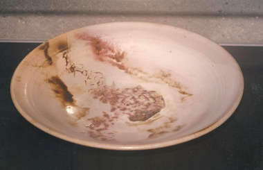
Bowl
According to Lloyd's Shipping Register 1837-1839, the CHILDREN was built in 1825 at Liverpool and operated by owners Gordon & Co, of London. London registered number 123/1837. James Henty then bought her in 1837 as a three-masted barque of 254 tons, with a hull of “part pitch pine, felt sheathed” and “coppered 1837”. Launceston registered number 6/1837. In 1838 the CHILDREN, under her master Captain H. Browne, completed a successful round trip from Launceston to London (carrying wool and whale oil loaded in Portland), returning in late November of that year (carrying a general cargo including the house bricks). On the 11th January 1839, the CHILDREN sailed from Launceston for Adelaide, with 24 passengers, 14 crew, and an awkward mixed cargo, including 1500 sheep, 8 bullocks, 7 horses, and farming implements, and six whaleboats with associated whaling gear. One account states that when the CHILDREN “put out from port she was light and badly ballasted”. The vessel immediately encountered four days of hurricane force storms, eventually clearing on the early morning of the 14th to “west force 10”, but too late to take accurate measurements of the sun or stars to establish their position relative to the coast. The CHILDREN collided with a limestone stack at the entrance of Childers Cove, and the seas smashed her into pieces within half an hour. All the cargo and 16 lives were lost (including 8 children). The Henty’s contributed £150 towards a fund for the 22 survivors at a memorial service held in Launceston later that year. It was a major financial setback for the Henty’s, but one from which they recovered. In a submission to the Governor of New South Wales dated 24 March 1840, the Henty’s summarised their work over the previous six years of settlement: “Six stations have been occupied, one at Portland Bay…three at the open country about 60 miles inland called ‘Merino Downs’…They have erected two houses at Portland Bay and two others at Merino Downs”. The shipwreck of the CHILDREN is of State significance ― Victorian Heritage Register S116Part of terracotta bowl from the wreck of the Children, 2 segments have been glued together.flagstaff hill, warrnambool, shipwrecked-coast, flagstaff-hill, flagstaff-hill-maritime-museum, maritime-museum, shipwreck-coast, flagstaff-hill-maritime-village, children -
 Flagstaff Hill Maritime Museum and Village
Brick
According to Lloyds Shipping Register 1837-1839, the CHILDREN was built in 1825 at Liverpool and operated by owners Gordon & Co, of London. London registered number 123/1837. James Henty then bought her in 1837 as a three-masted barque of 254 tons, with a hull of “part pitch pine, felt sheathed” and “coppered 1837”. Launceston registered number 6/1837. In 1838 the CHILDREN, under her master Captain H. Browne, completed a successful round trip from Launceston to London (carrying wool and whale oil loaded in Portland), returning in late November of that year (carrying a general cargo including the house bricks). On the 11th January 1839, the CHILDREN sailed from Launceston for Adelaide, with 24 passengers, 14 crew, and an awkward mixed cargo, including 1500 sheep, 8 bullocks, 7 horses, and farming implements, and six whaleboats with associated whaling gear. One account states that when the CHILDREN “put out from port she was light and badly ballasted”. The vessel immediately encountered four days of hurricane force storms, eventually clearing on the early morning of the 14th to “west force 10”, but too late to take accurate measurements of the sun or stars to establish their position relative to the coast. The CHILDREN collided with a limestone stack at the entrance of Childers Cove, and the seas smashed her into pieces within half an hour. All the cargo and 16 lives were lost (including 8 children). The Hentys contributed £150 towards a fund for the 22 survivors at a memorial service held in Launceston later that year. It was a major financial setback for the Henty’s, but one from which they recovered. In a submission to the Governor of New South Wales dated 24 March 1840, the Henty’s summarised their work over the previous six years of settlement: “Six stations have been occupied, one at Portland Bay…three at the open country about 60 miles inland called ‘Merino Downs’…They have erected two houses at Portland Bay and two others at Merino Downs”. The shipwreck of the CHILDREN is of State significance ― Victorian Heritage Register S116Fired brick from the wreck of the Children, flagstaff hill, warrnambool, shipwrecked-coast, flagstaff-hill, flagstaff-hill-maritime-museum, maritime-museum, shipwreck-coast, flagstaff-hill-maritime-village, children -
 Melbourne Tram Museum
Drawing, Melbourne & Metropolitan Tramways Board (MMTB), Aerial photographs Bundoora Tram Extensions, Plenty Road – MMTB Drawings – 12/1979, Bundoora Extension – Metropolitan Transit Authority – 2/1983, John-Connell – Mott Hay and Anderson – Preliminary drawings for the Latrobe Modal Interchange – August 1984, 1979 to 1984
Set of drawings for the MMTB Plenty Road extension in 1979, MTA extension to Bundoora in 1983 and the Latrobe Uni Modal Interchange - 1984. Large print – Aerial photographs Bundoora Tram Extensions Stage 2 – Albert St to Kingsbury Drive Stage 3 – Kingsbury Drive to Settlement Road Has been rolled, left hand edge damaged, right hand edge torn Compiled by the ROW Division – 2/1981. Has written on rear at right hand end “Bundoora Tram Extension – Official MMTB Plans” 760H x 1190W Plenty Road – MMTB Drawings – 12/1979 P15123 Tyler St to Walsal Avenue P15124 Walsal Ave t McColl St P15125 McColl St to Dorrington Avenue Bundoora Extension – Metropolitan Transit Authority – 2/1983 P15400 Dorrington Avenue to Barwon Avenue P15401 Barwon Avenue to Nicholson Ave P15402 Nicholson St to Barling Park P15403 Barling Park to Darebin Creek P15404 Darebin Creek to Scott Grove P15405 Scott Grove to Clunes Street P15406 Clunes St to Cash St P15408 Cash St to Bundoora Park P15409 Bundoora Park to Larundel Hospital P15410 At Larundel Hospital P15411 Larundel Hospital to Marne Court P15412 Marne Court to Cherrywood Court P15413 Cherrywood Court to Morwell Ave P15414 Morwell Ave to Grimshaw St P15415 Grimshaw St to Nickson Street P15416 Nickson St to McLeans Road John-Connell – Mott Hay and Anderson – Preliminary drawings for the Latrobe Modal Interchange – August 1984. 8094-A-20 Set Out Plan and Paving Details 8094-A-21 Elevations 8094-A-22 Sections 8094-A-23 Roof Plan and Stormwater Layout 8094-A-24 Canopy Details 8094-A-25 Toilet Block and Waiting Room 8094-A-28 Miscellaneous DetailsOn rear of aerial photograph sheet - at right hand end “Bundoora Tram Extension – Official MMTB Plans” in felt pen.trams, tramways, plenty rd, bundoora, latrobe university, mmtb, construction, mta -
 Kew Historical Society Inc
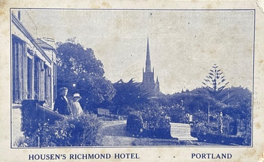
Postcard, Housen's Richmond Hotel | Portland
Many of the Henty's of the Western District of Victoria also owned houses in Kew, Victoria. Stephen Henty, referred to on the reverse of the postcard, lived while a member of the Vitoria Parliament at 'Findon' in Kew. Kew Historical Society also holds a nationally significant collection of costumes belonging to three generations of Henty women.Monochrome, blue tinted 'real photo' postcard of Housen's Richmond Hotel, Portland. Two women stand on the steps of the hotel at left, with the rose garden in front of them. Behind them is a church spire. The hotel and its significance is outlined in two columns of blue coloured text on the reverse.Printed reverse: "THE RICHMOND is the most historical building in the State. On the site of today's building Edward Henty, the founder of permanent settlement in Victoria, commenced his first house February 19, 1835, finishing the work in two months. He had landed in Portland on Nov. 19th, 1834, and turned the first plough furrows in Victoria where the Hotel now stands on the 26th of the following month. It was also here that Major Mitchell ended his explorations from Sydney, meeting the Hentys on August 29th, 1836. In December of the same year Mrs S. G. Henty joined her husband, their son Richmond, the first male white child in Portland, being born in the Henty cottage. The present Richmond Hotel was built in 1840, and became the home of Stephen Henty until his departure from Portland in 1869. Though Edward Henty's first house was demolished in 1840, to make room for the new surveyed town streets, part of his wool store remains in the Hotel grounds, and is used as a wood shed. This is about the oldest building in the State : in it was held the first christening service in Portland on September 26th, 1841. On the site of the Richmond Hotel all the early visiting celebrities were entertained - Mitchell, Wedge, La Trobe, Fyans, Sir John Franklin, Capt. Stokes, etc. No other hostelry in Victoria can give you the historical atmosphere of the RICHMOND. / THE ORIGINAL HOME OF THE HENTYS."henty family, richmond hotel -- portland (vic.), stephen henty, edward henty, richmond henty, henty houses -- victoria, portland, postcards -
 Eltham District Historical Society Inc
Photograph - Digital Photograph, Alan King, Kangaroo Ground General Store, Eltham-Yarra Glen Road, 28 December 2007
The present store was built circa 1900 to replace another which had been destroyed by fire in 1898, which had replaced a predecessor on the opposite side of the road in 1865. The store was also used as a post office until early 2000s. The general store is historically significant because it has a long association with Kangaroo Ground and has been an important centre of community life for more than 120 years - Council meetings used to be conducted in the front room of the store at a time when Kangaroo Ground rivalled Eltham as the major centre of the Shire. The general store is historically and aesthetically significant as one of a group of three well preserved public buildings in the Kangaroo Ground hamlet and as a major heritage component of Kangaroo Ground which was one of the earliest settled areas of the Shire and which has the character of an English village rather than an Australian settlement. Covered under Heritage Overlay, Nillumbik Planning Scheme. Published: Nillumbik Now and Then / Marguerite Marshall 2008; photographs Alan King with Marguerite Marshall.; p77 Today the general store is an uncommon form of trade but the one at Kangaroo Ground continues a long tradition of friendliness and service. For more than 100 years it has been a centre of community life. In the settlement’s early days a previous general store, on the same site, was the meeting place for the Eltham District Road Board, precursor to the Eltham Shire Council. For years Kangaroo Ground rivalled Eltham as the shire’s major centre. It developed very differently from the rest of the shire as its rich soil attracted prosperous Presbyterian Scots who had large agricultural properties.1 The present store was built to replace another one, which had burnt down in 1898, after replacing a predecessor on the other side of the road in 1865. The store retains its outward character and its cellar, although inside it has changed considerably. It now includes a café and offers local produce, milk bar products, grocery items, gas and other fuel. Until early this century the store was also used as a post office. Kangaroo Ground’s first postmaster was Andrew Ross, who first operated from the school opposite, then from his hotel next to the present tennis court site. The first postmaster at this store was Edward Weller, followed in 1868 by James Anderson. At that time a mail coach ran three times a week between Eltham and Woods Point through Kangaroo Ground, Yarra Flats, Healesville, Fernshaw, Marysville and Matlock. Some early postmasters were Rodger, McLaughlin, Greenway and Burns.2 Burns was the only postmaster operating from the store. The others operated from Andrew Ross’s hotel. The mail service improved in 1892 when coaches ran from Melbourne to Queenstown (now known as St Andrews) and changed horses at Kangaroo Ground twice daily. The only telegraph office in the district at that time was at the Kangaroo Ground Post Office. Telegrams to outlying areas such as Queenstown and Kinglake had to be sent by hand. A local resident in the early 1900s often rode his pony to deliver telegrams and was paid one shilling a mile porterage. The store has also contributed to the lighter side of Kangaroo Ground life. During the years that Con Wraight owned the store, between 1906 and 1946, a new piano was needed for the Kangaroo Ground Hall, so monthly dances were held to raise money. When the piano was bought, a grand ball was held in the Kangaroo Ground Hall to celebrate the occasion and supper followed at Mr Wraight’s barn, cleaned especially for the occasion. Every New Year’s Eve, a Scottish piper would set off from between the store and the schoolhouse, playing his pipes, and march to Cameron’s Pigeon Bank homestead on the Kangaroo Ground-Warrandyte Road. Between 1914 and 1922, the store was a station for the Kangaroo Ground Bush Fire Brigade’s tanker. It consisted of a wooden barrel on a cart, fitted with a hand-pump, and stood on the side of the road outside the store. Joy Ness, who belonged to an early Kangaroo Ground family, moved here in 1940 and recalled her impressions of the store at that time: ‘It was a very dark shop stained in a dark colour and on the walls just below the ceiling hung hurricane lamps, ropes, kitchen utensils and other goods for sale. ‘Goods were weighed on a brass scale with weights, on which mothers also weighed their babies, because the nearest Infant Welfare Centre was at Greensborough. The bacon was cut with a hand slicer and later a pot-bellied stove warmed the store. Farmers and other locals used to gossip around it as they collected their daily mail. In those days the butter and cheese were kept in the cellar as no ice was delivered for cooling.’This collection of almost 130 photos about places and people within the Shire of Nillumbik, an urban and rural municipality in Melbourne's north, contributes to an understanding of the history of the Shire. Published in 2008 immediately prior to the Black Saturday bushfires of February 7, 2009, it documents sites that were impacted, and in some cases destroyed by the fires. It includes photographs taken especially for the publication, creating a unique time capsule representing the Shire in the early 21st century. It remains the most recent comprehenesive publication devoted to the Shire's history connecting local residents to the past. nillumbik now and then (marshall-king) collection, eltham-yarra glen road, kangaroo ground general store -
 The Beechworth Burke Museum
Audio - Oral History, Jennifer Williams, Mrs Vanessa McDonald, 9 November 2000
Mrs. Vanessa McDonald was born in Beechworth in 1917. Christened, Agnes Bertha Collins, Vanessa changed her name in 1960. Mrs. McDonald's family's connection with gold mining in the district reach back to the first of Beechworth's gold rushes, when her great grandfather, a Dutchman who adopted the name Charles Collins, arrived in 1851-1852. Mrs. McDonald spent her childhood in the isolated hamlet of Stanley, in the area known as 'Little Scotland', where she recalls helping her mother to raise younger siblings, picking apples and walnuts on the family farm, and roaming the hills for wildflowers. As a young woman Mrs. McDonald attended religious and social gatherings in the local community. In 1940 she went to Melbourne to work as a mothercraft nurse during the Second World War. She met her husband at a Beechworth football match and was married at the Stanley Methodist Church in 1941. The gold diggings known as the 'Nine Mile' became the hamlet of Stanley, after the British Prime Minister, Lord Stanley, in 1858. By the late 1850s, Stanley boasted schools, an athenaeum, a church, a weekly newspaper and several hotels and other civic infrastructure to cater for a growing population. The area attracted large numbers of Chinese miners, whose presence was frequently resisted. Like other early Victorian mining settlements, Stanley was a hotbed of political and racial tensions during the gold rush. One side of the Nine Mile Creek was known as 'Little Scotland’, the other, 'Little Ireland'. A number of Christian denominations built congregations and churches in Stanley, including the Church of England, Methodist Church, the Catholic Church, and Presbyterian Church. Stanley became part of the United Shire of Beechworth in 1871. By 1880 timber was being cut and two sawmills were established by 1887. River-dredged gold mining consumed vast amounts of timber from the forests in the area, and in 1931 the first of several softwood plantations began. This oral history recording was part of a project conducted by Jennifer Williams in the year 2000 to capture the everyday life and struggles in Beechworth during the twentieth century. This project involved recording seventy oral histories on cassette tapes of local Beechworth residents which were then published in a book titled: 'Listen to what they say: voices of twentieth century Beechworth'. These cassette tapes were digitised in July 2021 with funds made available by the Friends of the Burke.Following the decline in the mining and associated industries during the early-mid-twentieth century, the Beechworth district experienced a period of general economic decline. On the east side of the Dingle Range, Mrs. McDonald's father, William Henry Collins, felled timber and the family were pioneer apple orchardists. The establishment of apple orchards in Stanley reflects changes to how land was used and contributes to our understanding of the historical development of rural communities following the gold rush. Mrs. McDonald's recollections are significant for understanding family and social life in a small rural town in years leading up to the Great Depression and prior to the Second World War. This oral history recording may be compared with other oral histories and items in the Burke Museum's collection. This oral history account is socially and historically significant as it is a part of a broader collection of interviews conducted by Jennifer Williams which were published in the book 'Listen to what they say: voices of twentieth-century Beechworth.' While the township of Beechworth is known for its history as a gold rush town, these accounts provide a unique insight into the day-to-day life of the town's residents during the 20th century, many of which will have now been lost if they had not been preserved.This is a digital copy of a recording that was originally captured on a cassette tape. The cassette tape is black with a horizontal white strip and is currently stored in a clear flat plastic rectangular container. It holds up 40 minutes of recordings on each side.Mrs Vanessa McDonald /listen to what they say, beechworth, oral history, burke museum, emigration, gold rush immigration, victorian gold rush, mining families, apple orchard, forestry, forest plantation, little scotland, stanley, twentieth century history, regional australia, rural australia, farming, harvest festival, great depression, dingle range, the nine mile, australian wildflowers, high country wildflowers, mothercraft nurse, rural and regional women, social history, collins, mrs. vanessa mcdonald, building community life, shaping cultural and creative life, fruit growers, family history, changes to land use in regional victoria -
 Eltham District Historical Society Inc
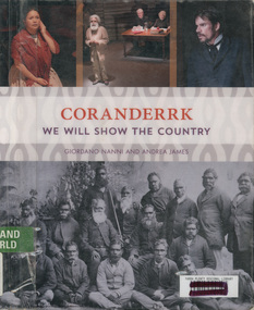
Book, Giordano Nanni et al, Coranderrk; We will show the country, 2013
Comprises twenty-three extracts from the Minutes of Evidence of the Coranderrk Inquiry, accompanied by an analysis of the historical text and context. The book relies strongly on primary-source materials and accurately references historical analysis from scholarly and Aboriginal perspectives. This book is derived from a verbatim-theatre performance in which professional actors portrayed the witnesses who gave evidence before the 1881 Coranderrk Inquiry.; Inscriptions and Markings: illustrations, photographs, facsimiles, maps, portraits About the book One of the first sustained campaigns for justice, land rights and self-determination in colonial Australia was undertaken by the Aboriginal people of Coranderrk reserve in central Victoria. Despite having created an award-winning farm they were targeted for removal to make way for white settlement. As skilled communicators and negotiators, they lobbied the government, in alliance with their white supporters, and succeeded in triggering a Parliamentary Inquiry in 1881. Coranderrk – We Will Show The Country derives from a unique verbatim-theatre performance where professional actors brought to life the witnesses who gave evidence before the 1881 Parliamentary Coranderrk Inquiry. Rescued from dusty archives, and including renowned Wurundjeri leader, William Barak, those witnesses continue to speak to contemporary audiences. Here, their powerful petitioning can be read alongside that of their non-Aboriginal allies, and those who would move them off their land. The book features a concise and accessible history of the Coranderrk Aboriginal Station and of the events that led to the appointment of the 1881 Parliamentary Coranderrk Inquiry. The book also contains a special edition of the verbatim script which has been annotated and referenced so as to provide a blueprint of how the original minutes of evidence from the 1881 Parliamentary Coranderrk Inquiry were adapted into a theatre script. Each scene of the play has also been introduced with a short biography of each character and a discussion of the key themes raised in their testimony. Supplementing the verbatim script of the performance, the book includes a range of historical images and stills from the ILBIJERRI Theatre Company’s production. Coranderrk – We Will Show The Country celebrates the spirit of collaboration between black and white in pursuit of justice, and offers an engaging way to learn about our past – and to think about our future. Coranderrk - We Will Show The Country. (2023, October 19). Retrieved from http://www.minutesofevidence.com.au/education/coranderrk-we-will-show-the-country-book/Ex Yarra Plenty Regional Library copyaboriginal australians, coranderrk, first nations people, healesville, indigenous history, performance, play -
 Uniting Church Archives - Synod of Victoria
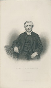
Engraving from photograph, Undated
James Watkin (1805–86), Pioneer Missionary. James Watkin was born in Manchester in 1805. While still young he felt the call to preach and in 1830 was accepted as a candidate for the Wesleyan Ministry. In the same year he married Hannah Entwistle and they sailed with a missionary party to Tonga. The work of the mission was jeopardised by prolonged and involved struggles between Christian and non-Christian Tongan chiefs; Watkin faced alone the danger of tribal warfare, but the experience left him depressed and exhausted. On his removal with his family to Sydney in September 1837 he prayed for a return home to England. Instead, when John Jones offered a free passage for a missionary appointed to Waikouaiti, where Jones had a whaling station, Watkin was selected for the post and arrived there in May 1840. Here he established the first mission station in the South Island. Watkin found the whaling settlement of Waikouaiti a centre of violence, licentiousness, and drunken depravity. Thoroughly disliking the corrupted Maoris and convinced that they were doomed to extinction, and disgusted by the brutality and vices of his fellow Europeans, Watkin laboured without hope, in the bitterness of exile and with deepening depression and distress. In spite of an abhorrence for his situation he established schools at Waikouaiti and Matanaka, and stationed partly trained Maori teachers at Stewart Island and at Moeraki. He had a natural flair for languages, preached in Maori four months after his arrival, and compiled an elementary reading book to be printed in Ngai Tahu. In November 1840 Watkin was greatly disturbed by Bishop Pompallier's visit to Otago. When, however, this was followed by Anglican intrusion – for Bishop Selwyn visited Otago in January 1844 – Watkin thought of withdrawing his own Maori teachers and abandoning the field. Never reconciled to his position at Waikouaiti, Watkin was relieved by Charles Creed and in June 1844 he sailed for Wellington, leaving 227 church members in Otago. In 1855 Watkin settled in New South Wales, and was president of the National Methodist Conference at Adelaide in 1862. He retired in 1869 and died on 14 May 1886, at Ashfield, New South Wales. 'WATKIN, James', from An Encyclopaedia of New Zealand, edited by A. H. McLintock, originally published in 1966. Te Ara - the Encyclopedia of New Zealand URL: http://www.TeAra.govt.nz/en/1966/watkin-james (accessed 30 Apr 2018) B & W engraving from a photograph of the Rev. James Watkin.Revd. James Watkin, Australia Engraved by J. Cochran from a Photograph. -
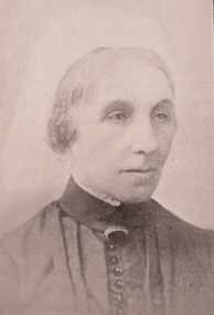 Ballarat Heritage Services
Photograph - Image, Mrs Stephen Henty of Portland
Stephen Henty married Jane Pace in Fremantle April 1836; four sons and six daughters were the issue of the marriage. Mrs. Stephen Henty was born in Yorkshire on 14 April 1812, and she died in Hamilton on 02 February 1906. She was the first white woman to settle permanently in Western Victoria, arriving in Portland on 18 December 1836. From a small booklet "Old Memories," written by Jane Henty on her 84th birthday. 'My husband and I arrived at Portland Bay in 1836, though he had made some trips there previously. It was on a Sunday night we landed by moonlight. I was carried on shore through the surf by a sailor. On reaching the homestead, a comfortable dwelling composed of four rooms, kitchen and dairy, a bright log fire was burning, table spread with a large pot loaf, piles of eggs and tea. Edward had not travelled inland, but my husband never rested until he had gone all through the interior, cut a track through 15 miles of forest land with two men and a dray, and arrived on the banks of the Wannon. He used to be absent for weeks at a time, causing me great anxiety. The natives were not to be trusted, so he usually took with him an expiree from Tasmania. Stephen Henty fixed all three of the first stations -Muntham, Merino Downs, and Sandford. In July 1837 Stephen sent some fine flocks of merino sheep to Muntham, having previously had a hut built for the men, and yards for the sheep; his two brothers, John and Frank, took charge of the sheep on the road. "On August 3, 1837, my son Richmond was born the very day the sheep arrived at Muntham. Edward was in Tasmania at the time, and arrived three weeks after the birth of my son, with his brother James and his son... My husband and Edward were in partnership, Edward managing Muntham, and Stephen the mercantile part at Portland Bay. John managed Sandford and Frank Merino Downs... My husband was the first white man who stood on the border of the Blue Lake at Mt. Gambier. He said he would never forget the feeling of awe he felt on coming suddenly on the blue water in the wilderness.("The Portland Bay Settlement", by Noel Learmonth, 1934)Black and white image Mrs Stephen Henty.stephen henty, portland, pioneer, women, jane henty, jane pace, merino downs -
 Federation University Art Collection
Ceramic - Platter, 'Platter No 131' by Milton Moon OA, 1979
Milton Moon (1926-2019) Born Melbourne, Victoria Milton Moon attended the Central Technical College, Brisbane where he studied painting and drawing. In 1950 he undertook study in Ceramics with Harry Menmott and Mervyn Feeney at the Sandison Pottery, Brisbane. He lectured in Ceramics at Central Technical College, Brisbane, and he was awarded a Churchill a Fellowship in 1966. In 1974 he travelled and worked in Japan for a year, and established a workshop at Summertown in the Adelaide Hills. In 1984 Milton Moon was awarded the Order of Australia Medal for his services to ceramics. Milton Moon died in 2019. At the time of his death his website included the following:- "In this, my 'ninety second year,' over sixty of which I have been a potter, I remain concerned, if a little obsessed, with the challenge of making pots, which although belonging to a ceramic tradition of some eight thousand years or more, are undeniably and uniquely Australian. With all my changes of expression this has remained constant. The initial creative inspirations were drawn from the beauty of the coastal areas of Eastern Australia and from the mountain areas of the Great Dividing Range which stretch from North Queensland to the extreme South of Victoria. But the most lasting inspiration has come from the inland of Australia, more particularly from the Gammon and Flinders Ranges and from the Olary Uplands of South Australia, and more recently the Pilbara and Kimberley areas of Western Australia, where rock engravings place them as being amongst the oldest marks left by human-kind anywhere in the world. All parts of Australia are full of an ancient history stretching back through time and which today, despite white settlement, somehow still survives in legend and ritual. If it is the case that these legends do now only exist, in some muted half-life there is still the sense that they remain as a very powerful 'spirit-presence.' It is impossible to ignore the feeling that this country remains inhabited by the past. For me it is also impossible not to creatively respond to the echoes of the past, even if only through the somewhat vague process of inspiration and distillation. To understand this spirit, even a little, is a privilege but to try an express it is a compelling endeavour. This item is part of the Federation University Art Collection. The Art Collection features over 2000 works and was listed as a 'Ballarat Treasure' in 2007.Large ceramic platter, framed for display on wall.art, artwork, milton moon, ceramics -
Glen Eira Historical Society
Letter - ELSTERNWICK POST OFFICE
This file contains seven items about the significance of this building and how this was established : 1/ Photocopies of a handwritten application (in duplicate) by Walter Kay of Elsternwick dated 13/10/1985 and Rodney H Bush’s dated 16/10/1985 to the Historic Buildings Council to register the former Elsternwick Post Office building, and an original typewritten letter dated 17/10/1985 from the Historic Buildings Council to Caulfield and Historic Society advising them of an application and inviting them to submit relevant information about the building with a copy of application attached. 2/ Six pieces of correspondence between various interested parties (Caulfield Council , Caulfield Historical Society, National Trust, of Australia and Ministry for Planning and Environment on behalf of Historic Buildings Council, Victoria) about the significance of the former Elsternwick Post Office building and the progress of efforts to include it on the Register of Historic buildings. Dated between November 1985 and May 1986. 3/ Two pieces of correspondence between the Caulfield Progress Association and the Caulfield Historical Society dated April and May 1986, regarding the efforts of the Historical Society to save the former Elsternwick Post Office building. 4/ Two pieces of ephemera by the Caulfield Progress Association, one original undated and one photocopy undated in 1986. Both appealing to the public for support to help the former Elsternwick Post Office building and to protest a proposal to demolish it, by Caulfield Council. 5/Original newspaper article dated 07/06/1989 from the Malvern-Caulfield Progress newspaper written by Robert Carmody. The article talks about the approval by the Historic Buildings Council of Caulfield Council’s restoration program of the former Elsternwick Post Office building worth approximately $850,000. The refurbishment would consist of a shop and office space which would then be rented out. Mayor Emil Braun outlines the progress to implement the plans. 6/ Caulfield Conservation Study by Andrew Ward dated September 1994 of former Elsternwick Post Office Building. The building plans for the Elizabethan Style building were approved in 1891. The original timber verandahs were replaced by the present brickworks in circa 1918 rear extensions in 1941-42. Similar Post Offices were built at Kew, Queenscliff and Portarlington. 7/ Computer printout dated 19/03/2010 of Statement of Significance held by the Victorian Heritage database of the former Elsternwick Post Office Building. It was built in 1891 in the ‘Queen Anne’ style. The substantial two story red brick building was set on a bluestone plinth with an ornate façade incorporating cement dressings. There is a brief summary of the settlement and development of the Elsternwick area with mention of how important the building is to the Elsternwick Community. Original date and author is unknown.elsternwick post office, glenhuntly road, elsternwick, riddell parade, office buildings, postal services, caulfield city council, kay walter, regent street, caulfield, bush rodney h, gisborne street, city of caulfield, braun emil councillor, mayors, aylen doug, aylen douglas r, historic buildings council, caulfield historical society, ministry for planning and environment, head stephen, historic buildings act 1981, anderson p, national trust of australia (victoria), public works department, architectural styles, calder g.k. councillor, wills cathie, lyall kerry, marsden john hudson, town clerk, hill douglas, caulfield progress association, caulfield south, glen eira road, hawthorn road, mac neil j.r., neville street, glenhuntly, marten veronika, ballantyne richard, royal historical society of victoria, dunstan don, alfada street south, hardy joan, baird rob, snowball betty, ward andrew, hoddle robert, foot henry, ebden charles hodson, elster, oldham mary kate, english ‘queen anne’ revival style, rifle club, coulson herbert h., fick p.g., railway, city manager, austin g.b. h., architects, builders, architectural features, australia post, register of historical buildings, grey karen, planning appeal board, heritage overlay no h029, victorian government gazette no. 60 dated 16/07/1986, historic building no640, certificate of title volume 5817, kennan james harley, nelson ivor, blake alison, neale anne, telegraph offices, wardell, ward andrew -
Glen Eira Historical Society
Drawing - St. Stephen’s Presbyterian Church, Caulfield
... Settlements ...Two copies of a sixteen page booklet titled First Fifty Years, detailing a brief history, researched by John Watson, of St. Stephen’s Presbyterian Church, Balaclava Road Caulfield, between 1910-1960. The booklet includes several images, including two photographs, one of the interior of the church, the other of the interior of the main hall. There is also a set of six portrait photographs of the ministers of St. Stephen’s from 1913-1960. There is also a photograph of the front view of the first church and a sketch by Haddon and Henderson architects of the design for the present, 1960, church dated to the early-mid 1920s. There is a list of names of office-bearers for the year 1960. That list has been photocopied and is included in the file. Finally, there are two pages of handwritten notes, undated and unattributed, of information about St. Stephen’s derived from the First Fifty Years booklet.caulfield, st. stephen’s presbyterian church, presbyterian church, balaclava road, caulfield west, oulton street, watson john, kerry gordon f.g. rev., currie george, kinross george, haddon robert, thomson william rev., pollard mr., hunter c. hay m.a. rev., burns hugh m.m.a.b.d. rev., tamagno f. rev., simpson w.l. rev., goddard s.a.m.a.b.d. rev., robinson e.b. rev., adamson j. mr., jamieson r.f. mr., fraser w. mr., tannahill a.s. mr., mcilroy r. mr., smith f.b. mr., josephs a. mr., mac callum d. mr., darby g. mr., watson t.c. mr., attwood w.b. mr., wells organisation, land subdivisions, clergy residences, churches, settlements, community services, sunday schools, religious structures and establishments, architectural features, stained glass, paintings, farms, religious groups, ministers, monuments and memorials, clubs and associations, sporting clubs, p.w.m.u., presbyterian women’s missionary union, p.f.a., p.b.a., p.g.a., men’s brotherhood, soldier’s welfare association, youth executive, women’s league, dramatic club, halls, committees of management, building construction, fundraising events, business and finance, festivals and celebrations, religious ceremonies, architects, choirs, christian religion -
 Mt Dandenong & District Historical Society Inc.
Photograph, Post Office and 'Mountjoy', Mt. Dandenong North, 1913
Rose Series post card #182Copy of Rose Series postcard #182 showing Kalorama Gap in 1913. Haystacks in foreground with Mountjoy Guest House and Beulah Tea Rooms/Mt Dandenong North Post Office in centre. This photograph has a detailed inscription on the back handwritten by John Lundy-Clarke in 1974.Kalorama Gap in 1913 The elm trees are in the centre of the picture. One of these is really two as two suckers of the further tree were twisted together by Fred Jeeves in 1898 and grew as one tree. The other was planted in 1880. The shop is the shop of Mrs Eliza Hand and daughter Florence. The closed in far end of the verandah was the Mount Dandenong North Post Office. The large house is “Mountjoy” owned and run by the Jeeves Family from 1908 till 1943. It was built in 1905 by the Paynters who sold to Ellis Jeeves in 1908.He moved his line of coaches from “Kalorama” his old homestead and housed the horses in a line of stables behind “Mountjoy”. Price’s house, which contained their shop, the first one on the mountain, opened 1906, can be seen faintly behind the pine tree opposite the bend in the road, which was the main road then and now is Ridge Road. The Price’s house just shows in two tiny pieces, one on each side of the pine tree half way up. The house to the right of and high up the pine tree is Walker’s cottage which exists today opposite Jack Kidd’s home at the far edge of Lt 2 Village Settlement and was between Main Road and Barbers Road which runs down the left behind the elms. Walker’s homestead can be seen near left edge of picture 2/3 way up. The roof of the Methodist Church shows among trees left of picture. This, like Mrs Hand’s shop was built on portions separated from Isaac Jeeves’ Selection “C” known as Jeeves Saddle. kalorama gap, five ways, mountjoy, john lundy-clarke, beulah tea rooms, post office, fred jeeves, paynter, jeeves, frederick jeeves, price, walker, jack kidd -
 Flagstaff Hill Maritime Museum and Village
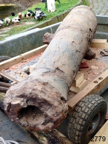
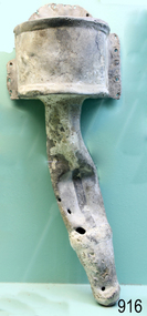
Weapon - Cannon, circa 1825
HISTORICAL INFORMATION In an article dated 26 March 1963, the Warrnambool Standard reported: “A cannon which has lain on the ocean floor since the barque, Children, was wrecked at Childer’s Cove on January 15, 1839, was raised by three Warrnambool skindivers at the week-end…The cannon, weighing about 750 lb. and 4-ft. 6-in. in length…is in excellent order considering the length of time it has remained under-water”. No conservation measures were taken at that time, other than chipping off the marine growth with hammers and cold chisels. The minutes for the 4 February 1974 meeting of the Flagstaff Hill Planning Board recorded that “a cannon recovered some time ago was lying in the garden of [one of the three original divers] and that it could be picked up at any time”. Peter Ronald, past Manager and Diver for Flagstaff Hill, notes that the CHILDREN cannon would have been recovered by the other divers around 1964. When the cannon came into care of Flagstaff Hill it was given basic conservation relevant to the time. (At the same meeting the Board was advised of the recovery of an anchor from the wreck of the CHILDREN by Flagstaff Hill divers (Peter Ronald, Colin Goodall and Gary Hayden, and Hank Howey and Andrew Coffee), and its interim relocation in the sea at the end of the Warrnambool Breakwater while awaiting conservation). The CHILDREN was owned by the pioneering Henty family of Portland. She was en route from Launceston to Adelaide, when she foundered in rough conditions at Childers Cove on 14 January 1839. The CHILDREN was a small three-masted barque, only 29 metres long and 254 tons weight, with 14 crew members and 24 passengers (including 9 children) on board. The ship was also carrying an awkwardly ballasted cargo of 1500 sheep, 8 bullocks, 7 horses, 5000 London house bricks, 6 whaling boats, and general trade goods. When the CHILDREN was driven into the limestone stack at the entrance to the cove, the seas smashed her into pieces within half an hour, and 16 lives were lost. The CHILDREN was an all-wooden ship, built in 1825 at Liverpool, and her shipwreck in 1839 is one of colonial Victoria’s earliest and most significant maritime disasters. There is little left to mark the tragedy on the seabed now, apart from some of the house bricks intended for the Henty’s Portland Bay settlement. Despite its poor condition, the CHILDREN’s signal cannon remains an important and interpretable record of her demise, (along with her anchor, the bottom half of her ship’s bell, and portions of a brass porthole - artefacts that are also in the Flagstaff Hill collection). In 2015 the CHILDREN cannon will undergo further conservation. (Conservation Management Plan for Victorian Guns and Cannon, South Western Victoria, May 2008, ref W/F/06) The shipwreck of the CHILDREN is of state significance — Victorian Heritage Register No. S116.A 1.3 metre iron 6pdr cannon recovered from the wreck of the CHILDREN. The shape of the cannon tapers from a thick round breech to a flared muzzle, with an 8 centimetre bore, and two side trunnions for pivoting on a wooden gun carriage. It was recovered from the shipwreck site of the CHILDREN by local divers in 1963. This small muzzle-loading signal cannon is in poor and unrestored condition. The cannon’s upper profile of smooth grey metal casing has corroded off, leaving an extensively oxidised rough red surface of crumbling iron. The bottom half of the cannon remains intact although the outer smooth casing also appears to be separating from the iron core of the barrel. Original grey casting is also missing from the breech and muzzle ends of the cannon. Corrosion and spalling of the upper surface layer of the cannon has removed the maker’s marks and specificationsflagstaff hill, warrnambool, shipwrecked coast, flagstaff hill maritime museum, maritime museum, shipwreck coast, flagstaff hill maritime village, great ocean road, the children, ship’s cannon, signal cannon, childers cove, 1839 shipwreck, conservation of marine artefactsm, shipwreck-coast, flagstaff-hill-maritime-village, cannon, 6pdr small bore cannon, children cannon, defence, children, shipwreck, 1839 -
 Eltham District Historical Society Inc
Photograph - Digital Photograph, Alan King, St Margaret's Anglican Church, Pitt Street, Eltham, 30 January 2008
St Margaret’s Church of England was officially opened on December 12, 1861. It is the oldest intact church building in Eltham. At the time it was known as Christ Church until its consecration in 1871, when it was completely free of debt (£1,700 for the church and parsonage) despite the district’s poverty. This was largely due to the free labour and materials, including locally made bricks donated by local artisans and others. The church is historically significant because it is the oldest church in the former Shire of Eltham and has associations with the philanthropist and founder of Brighton, Henry Dendy (who donated the land on which the church is built), the architect Nathaniel Billing and the prominent local builder, George Stebbing. The church is architecturally and aesthetically significant because it is constructed in the Gothic Revival style with several stained-glass windows of various dates and is also a very early use of polychromatic brickwork in Victoria. Billing was one of the first Melbourne architects to employ polychromatic brickwork and an important early architect. The rear wall was intended to be temporary. A major feature of the design is the large buttresses with long, steeply graded upper faces. The overall design is well proportioned with the surface brick patterns relieving an otherwise austere design. The church is spiritually and socially significant because it has been an important place of worship for the people of Eltham for almost 150 years. The land on which the buildings stand was donated by Henry Dendy. Dendy arrived in Melbourne in 1841 after purchasing in England eight square miles at Brighton under the system of "special surveys". After this land passed out of his hands, Dendy moved about Victoria, visited England, then returned to settle in Eltham where he purchased a flour mill. Dendy chaired the meeting held in 1860 “for the purpose of devising such means as may be expedient for the establishment of a Church of England in the township of Eltham”. He became chairman and treasurer of the church committee. Unlike the establishment of many early churches in Victoria where a vicar was appointed to a parish and later a permanent church was constructed, the population at Eltham initiated action to build a church. The nearest church at that time was at Heidelberg and the Eltham settlement was part of the parish of St Johns Heidelberg. Isolation and the tedious, time consuming journey between Heidelberg and Eltham resulted in the Eltham community taking its own action. The original vicarage (Dendy House) at the rear of the church is also an important part of the cultural significance of this place because it is connected to the church and the development of the Eltham area. Together, the church and the vicarage are aesthetically significant because they form a significant streetscape feature. The mud-brick community hall designed by Robert Marshall was added in 1978. In 2014 the original temporary rear wall was removed as part of a modern extension designed by Architects Atelier Wagner and constructed by Conrad Construction and Management. Covered under Heritage Overlay, Nillumbik Planning Scheme. National Trust of Australia (Victoria) State significance Victorian Heritage Published: Nillumbik Now and Then / Marguerite Marshall 2008; photographs Alan King with Marguerite Marshall.; p67This collection of almost 130 photos about places and people within the Shire of Nillumbik, an urban and rural municipality in Melbourne's north, contributes to an understanding of the history of the Shire. Published in 2008 immediately prior to the Black Saturday bushfires of February 7, 2009, it documents sites that were impacted, and in some cases destroyed by the fires. It includes photographs taken especially for the publication, creating a unique time capsule representing the Shire in the early 21st century. It remains the most recent comprehenesive publication devoted to the Shire's history connecting local residents to the past. nillumbik now and then (marshall-king) collection, eltham, st margaret's anglican church, st margaret's church, christ church -
 Eltham District Historical Society Inc
Photograph - Digital Photograph, Marguerite Marshall, Parish Hall, St John's Anglican Church, Diamond Creek, 7 September 2008
The building was designed by Charles Maplestone of Heidelberg, son-in-law to Anthony Beale of St Helena. Maplestone was a prominent architect who came out to Australia with his family in 1852. The foundation stone was laid by Mrs Isabella Maplestone on 11th November 1867. The bricklayers for the church were George Stebbing, H Limmer, H Spicer and a Mr Timm while Thomas Day was the stonemason. Another three years were to pass before sufficient money could be raised for its completion. It was opened by Bishop Perry on 1st November, 1870. The church bell which hung under a tree for 50 years until it was incorporated in the parish hall was brought out from England and presented by Charles Orme. In 1916, the estate of George Martin Pizzey left sufficient money to build the red brick hall, which still stands today (2023) though in January 1969 the hall and bell tower were badly damaged by bushfire. Coincidentally the former home of benefactor, George Pizzey was destroyed in the same fire. Of particular significance are the interior and exterior of the church, the Sunday school and hall with emphasis on pre-World War I fabric (excluding the 1990s additions) and the three coloured glass windows currently suspended in the 1990s entry foyer. In 2011 further alterations were made to the front of the Church. The church is historically significant because it was the oldest public building in the former Diamond Valley Shire, is amongst the oldest buildings in the Shire of Nillumbik and is associated with the early settlement of the Diamond Creek district. The church is historically, socially and spiritually significant because it has been a place of worship for over 150 years and continues to be, an important meeting place in the Shire. The church is aesthetically significant for the three stained glass windows executed by the noted stained glass manufacturers, Ferguson & Urie, as well as the supporting coloured glass windows in the church. The Sunday school & parish hall is architecturally significant because the hall is a well executed and preserved example of the work of noted church architects, North & Williams. It is historically significant because it is connected with local parishioner and Melbourne industrialist, George Pizzey, who bequeathed funds for its construction. Covered under Heritage Overlay, Nillumbik Planning Scheme. National Estate Ntionl Trust of Australia (Victoria) Local significance Published: Nillumbik Now and Then / Marguerite Marshall 2008; photographs Alan King with Marguerite Marshall.; p85 References: St Johns Anglican Church complex, Sunday School and Parish Hall 61 Main Street DIAMOND CREEK, NILLUMBIK SHIRE. (2023, June 7). Retrieved from https://vhd.heritagecouncil.vic.gov.au/places/64023 Diamond Creek, VIC. – St John’s Anglican (2023, June 7). Retrieved from https://www.churchhistories.net.au/church-catalog/diamond-creek-vic-st-johns-anglican This collection of almost 130 photos about places and people within the Shire of Nillumbik, an urban and rural municipality in Melbourne's north, contributes to an understanding of the history of the Shire. Published in 2008 immediately prior to the Black Saturday bushfires of February 7, 2009, it documents sites that were impacted, and in some cases destroyed by the fires. It includes photographs taken especially for the publication, creating a unique time capsule representing the Shire in the early 21st century. It remains the most recent comprehenesive publication devoted to the Shire's history connecting local residents to the past. nillumbik now and then (marshall-king) collection, st john's anglican church, diamond creek, parish hall -
 Flagstaff Hill Maritime Museum and Village
Functional object - Nail, circa 1825
Nails such as this solid copper nail were forged by blacksmiths. A nail of this length could have been used for the ship's decking. It was recovered from the shipwreck of the barque Children. The Children wrecking: The barque Children was one of the first vessels to be lost in the Western District the vessel was wrecked to the east of Warrnambool on 14th January 1838. When it ran ashore in hurricane-force winds, 22 passengers and crew were fortunate to escape being battered to death on the rocks. The Children broke up within 20 minutes, sweeping sixteen of those on board to their deaths. After eleven days, the survivors, all of whom were injured, were rescued and taken to Portland. According to Lloyd's Shipping Register 1837-1839, the Children was built in 1825 at Liverpool and operated by owners Gordon & Co, of London. Registration number 123/1837, James Henty then bought her in 1837 as a three-masted barque of 254 tons, with a hull of “part pitch pine, felt sheathed” and “coppered in 1837” at Launceston registered number 6/1837. In 1838 the Children, under her master Captain H. Browne, completed a successful round trip from Launceston to London (carrying wool and whale oil loaded in Portland), returning in late November of that year carrying a general cargo including house bricks used for ballast. On the 11th of January 1839, the Children sailed from Launceston for Adelaide, with 24 passengers, 14 crew, and an awkward mixed cargo, including 1500 sheep, 8 bullocks, 7 horses, and farming implements, and six whaleboats with associated whaling gear. One account states that when the Children were “put out from port she was light and badly ballasted”. The vessel immediately encountered four days of hurricane-force storms, eventually clearing on the early morning of the 14th. However, it was too late to take accurate measurements of the sun or stars to establish their position relative to the coast. The Children collided with a limestone stack at the entrance of Childers Cove, and the seas smashed her into pieces within half an hour. All the cargo and 16 lives were lost including 8 children. The Henty brothers contributed £150 towards a fund for the 22 survivors at a memorial service held in Launceston later that year. It was a major financial setback for James Henty and his brothers, but one from which they recovered. In a submission to the Governor of New South Wales dated 24 March 1840, the Henty’s summarised their work over the previous six years of establishing the Portland settlement stating. “Six stations have been occupied, one at Portland Bay three at the open country about 60 miles inland called ‘Merino Downs’ They have erected two houses at Portland Bay and two others at Merino Downs”.This nail is significant as part of the vessels original fixtures. The Children was delivering cargo intended for the Portland Bay settlement of her owners the James Henty brothers The wreck is also significant as one of the first vessels to have been lost in the Western District of Warrnambool. As a result the shipwreck of the Children is registered with the Victorian Heritage Register S116. Ship's nail, copper, with a washer attached. The nail has a round head, solid round shank and a flat end. It is bent, twisted and has indentations in the centre section. The nail was recovered from the wreck of the CHILDREN.warrnambool, flagstaff-hill-maritime-museum, shipwreck-coast, shipwreck artefact, the children, nail, copper nail, ship's nail, children shipwreck -
 Federation University Historical Collection
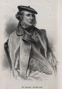
Drawing - Image - black and white, Angus McMillan, c1835
Angus McMillan named the Avon River after the river of the same name in his native Scotland. In 1840 he established a pastoral run at Bushy Park, north-west of the township. William Odell Raymond established a run in the area in 1842, and built his house, Strathfieldsaye, during 1848–54. European settlement did not take place without resistance, and in return, massacres were inflicted by Angus McMillan and others on Gunai people, especially between the years of 1840 and 1850. (wikipedia) The first application for the 'Bushy Park' run appears in the “Port Phillip Gazette” on 13 August 1843. It was taken up by Angus McMillan, who also took up the 'Boisdale' run for his employer Lachlan Macalister at the same time. In March 1844 a Licence to occupy the 16,000 acre 'Bushy Park' was granted to McMillan. In the late 1840s Andrew Martin and Matt McCraw built Angus McMillan's Bushy Park homestead. Aboriginal killings in Gippsland area most often were never formally recorded, but lived on in folklore, mainly in place names pinpointing what some historians now refer to as "massacres", and others as "conflicts". There is Boney Point, on Lake Wellington, Butchers Creek, near Metung, Slaughterhouse Gully, at Buchan, Skull Creek, at Lindenow, and, notoriously, Warrigal Creek, at Woodside. "Here, according to a couple of contemporary - though not eyewitness - reports, between 50 and 150 blacks were killed in an orgy of revenge after the murder and mutilation of a leading Scots settler, Ronald Macalister. If anybody had any doubts about the fitness of commemorating McMillan's name, no one voiced them then. Gippsland was, and still is, dotted with stone cairns tracing his route from Omeo, down the Tambo Valley to the fertile plains where he was to make (and lose) his fortune. And where, according to a growing body of opinion, he was to lead the "Highland Brigade", a band of armed settlers, against the Kurnai. History is fiction agreed on, and it is written by the winners. For most of the past 150 years, McMillan has been hailed as a trail-blazing pioneer. The legend began to crumble 20 years ago with publication of new histories, which at first outraged Gippsland historical societies and old residents, but which have gradually changed the way McMillan is viewed. ... Still, not all McMillan's contemporaries agreed with the "Highland Brigade" and its methods. Henry Meyrick, an English-born squatter, wrote to relatives in disgust about his neighbours. He estimated that 450 had been killed, and wrote: "Men, women and children are shot down whenever they can be met with. Some excuse might be found for shooting the men by those who are daily getting their cattle speared, but what they can urge in their excuse who shoot the women and children I cannot conceive." (http://www.theage.com.au/articles/2002/04/26/1019441303552.html, accessed 20 September 2016.) The Gippsland electorate is called 'McMillan' in his honour. Black and white image of a man wearing a coat and beret. He is Scottish born Victorian Squatter Angus McMillan of Bushy Park, Gippsland.angus mcmillan, squatter, aboriginal massacre, bushy park, gunai, avon river, pioneer -
 Duldig Studio museum + sculpture garden
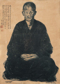
Drawing, Karl Duldig, The Buddhist Monk, Guangqia by Karl Duldig 1940, 1940
The Buddhist monk Guangqia visited Karl Duldig’s studio on two consecutive days, in the company of the noted Chinese writer, Professor Yu Dafu, a friend of Karl’s. Karl made two portraits of the monk, the first depicting him sitting, and the second in a standing pose. The portraits were drawn using a Chinese brush and Indian ink. Surviving sketches in the Studio’s collection indicate that Karl thought about creating a life-size sculpture later on, but this was not realised. Guangqia added inscriptions in his own hand to both drawings and stamped them with a red seal. The seated drawing has an inscription in which he quoted from a Buddhist poem, ‘A Contented Mind’ by the scholar Lingfeng of Mt Tiantai. In the summer I went to visit the Austrian sculptor Duldig with Professor Yu Da Fu. My virtue is slight – I cannot accept your offerings and gifts; I am amply rewarded by the clouds and springs. Rather than a table laden with pearl-like rice, I prefer the wind and leaves falling on my bed. Sitting quietly on my meditation cushion Is sweeter than the wheat offered by a thousand families. The pity is that I am gradually growing old; My bitter journey is not worthy of your offerings. The second drawing has a quote from a Buddhist poem on the study of Chán (Zen) Buddhism, by the famed Chán master, Dàjiàn Huìnéng (638–713): The portrait, with its figure positioned on a scroll-like ground and inscription is reminiscent of traditional Zen Buddhist portraiture. In this school of portraiture, which stretched back to at least the thirteenth century, monks were depicted sitting or standing facing the viewer, and typically the monk added an autographic inscription to the portrait. The portraits were often passed from master to disciple, continuing the disciples’ journey of spiritual enlightenment and were revered for their association with remarkable or holy priests. The Buddhist monk, Guangqai who added his inscription and stamp to the drawings would most certainly have been aware of this tradition. It is likely that Karl was aware of this tradition, one of the points where the studio’s collections of art works from Singapore intersect with the earlier Viennese collections can be found in the Library where a catalogue of an exhibition, 'Ausstellung Ostasiatischer Malerie und Graphik' is held. The Viennese Friends of Asian Art and Culture and the Albertina Museum staged this exhibition of East Asian painting and graphic works in 1932. Such was the internationalism of Duldig’s education in Vienna, that adaption to a new environment and culture in the Straits Settlement was swift, and he was able to interpret the artistic traditions of the place, and make them his own. It is part of the strength of the collection, that in many cases contemporary supporting documentation for the works of art is available. In this case there is a photograph of the Monk with Yu Ta-fu, and Karl and Eva Duldig, outside the studio at the time the drawings were made. Ann Carew 2016The portraits of Guangqai have national and international aesthetic significance. The works of art demonstrate the artist’s skill in capturing the physical appearance and demeanour of his subject, and his ability to adapt his working methods to incorporate traditional Asian materials and cultural practices. The portrait is one of few examples in Melbourne of a central European modernist artists working in, and engaging with Asia, during this period and it is culturally and aesthetically significant for this reason. The portraits are also historically interesting in documenting the life and experiences of Karl Duldig in the Straits Settlement (Singapore). Ann Carew 2016Brush drawing in chinese ink on paper. Seated Buddhist Monk. Chinese calligraphy hand written in black ink. Two red stamps under calligraphy.Signed Karl Duldig in l.r. corner. Dated Singapore 1940 in l.l. corner. -
Glen Eira Historical Society
Document - Bakewell Family
... Settlements ...There are 3 items about this family of early European settlers in Victoria: 1/A photocopy of an extract “Early Pioneer Families of Victoria and Riverina” – Henderson Page 441-442 The Bakewell Family of Burnewang and Tooradin”. It includes a photo of John Bakewell (1807-1888). It contains two pages and describes Bakewell’s property expansion. 2/An original copy of handwritten, unsigned undated research notes on John Bakewell property holdings taken from St Kilda Rate Book (1859-1873). It describes the land allotment. 3/A typed, unsigned, undated extract from 'The Howitts in Australia by Mary Howitt' - Mary Howitt, Vic Hist Mag 1913 Vol 3 No. 1. Reference – Memoirs of a Stockman, Harry Peck, 1853 Map, Foot Plot CCXLVI at Kooyong & Glen Eira Road. It provides a brief outline of the lives of brothers Robert and John Bakewell.the bakewell family, early pioneer families, henderson, bakewell john, port phillip, burnewang, bakewell robert, howitt godfrey dr, lord goderich, tooradin, phoebe, friends' school ackworth, yorkshire, nottingham, shaw john wyberg, plenty river, businesses, goldsbrough richard, goldsbrough mort and company ltd., glaziers, squatters, burnewang, mantons, tooradin, red bluff, torbinurruck, great swamp, brenanah, westernport, numerella, snowy river, orbost, green hills b, caramut, lyall william, mickle john, buckland john, notts, england, balderton, weddings, jane emily, howitt emanuel, farnsfield, lever mary, howitt thomas, heanor, derbyshire, howitt godfrey, scales john, exeter college oxford, downing college cambridge, guerard von, wayne john, south warnborough manor, harrison robert, lord john, jamaica, mary alice, dr. miller, miller john francis compton, emmie joan, mary emily, clifton hotel welbeck street, phoebe alice, anne edith, british museum, land values, settlements, st. kilda, elsternwick, inkerman street, st. kilda east, kew, memoirs of a stockman, harry peck -
 Flagstaff Hill Maritime Museum and Village
Functional object - Urinal, circa 1825
It is probable that the urinal was situated in the forward part of the ship rather than the stern, being one of two placed on either side of the deck and housed immediately adjacent to the doors into for-castle, or crew sleeping quarters. The toilets on maritime vessels were (and still are) called the ‘heads’, after the sanitation arrangements common until the end of the eighteenth century. The name was given to the ‘head’ of the ship, forward of the forecastle and around the beak or bowsprit. These first lavatories were floored with grating or nets so the force of the sea could wash them clean, and they were always used on the lee or non-weather side so the effluent fell directly into the water rather than back on board. The Children wrecking: The barque Children was one of the first vessels to be lost in the Western District the vessel was wrecked to the east of Warrnambool on 14th January 1838. When it ran ashore in hurricane-force winds, 22 passengers and crew were fortunate to escape being battered to death on the rocks. The Children broke up within 20 minutes, sweeping sixteen of those on board to their deaths. After eleven days, the survivors, all of whom were injured, were rescued and taken to Portland. According to Lloyd's Shipping Register 1837-1839, the Children was built in 1825 at Liverpool and operated by owners Gordon & Co, of London. Registration number 123/1837, James Henty then bought her in 1837 as a three-masted barque of 254 tons, with a hull of “part pitch pine, felt sheathed” and “coppered in 1837” at Launceston registered number 6/1837. In 1838 the Children, under her master Captain H. Browne, completed a successful round trip from Launceston to London (carrying wool and whale oil loaded in Portland), returning in late November of that year carrying a general cargo including house bricks used for ballast. On the 11th of January 1839, the Children sailed from Launceston for Adelaide, with 24 passengers, 14 crew, and an awkward mixed cargo, including 1500 sheep, 8 bullocks, 7 horses, and farming implements, and six whaleboats with associated whaling gear. One account states that when the Children were “put out from port she was light and badly ballasted”. The vessel immediately encountered four days of hurricane-force storms, eventually clearing on the early morning of the 14th. However, it was too late to take accurate measurements of the sun or stars to establish their position relative to the coast. The Children collided with a limestone stack at the entrance of Childers Cove, and the seas smashed her into pieces within half an hour. All the cargo and 16 lives were lost including 8 children. The Henty brothers contributed £150 towards a fund for the 22 survivors at a memorial service held in Launceston later that year. It was a major financial setback for James Henty and his brothers, but one from which they recovered. In a submission to the Governor of New South Wales dated 24 March 1840, the Henty’s summarised their work over the previous six years of establishing the Portland settlement stating. “Six stations have been occupied, one at Portland Bay three at the open country about 60 miles inland called ‘Merino Downs’ They have erected two houses at Portland Bay and two others at Merino Downs”.This urinal is significant as part of the vessels original fittings he Children was delivering cargo intended for the Portland Bay settlement of her owners the James Henty brothers The wreck is also significant as one of the first vessels to have been lost in the Western District of Warrnambool. As a result the shipwreck of the Children is registered with the Victorian Heritage Register S116. A lead urinal with a rounded back at the top splash plate with an attached semi-circular receptacle or basin (20cm deep and projecting forward 30cm). At the sides are flanges with bolt holes connecting to a ship's wall. The urinal is drained by a funnel-shaped outlet also made of lead, reducing from a 10cm radius to a joined 5 cm pipe. The urinal was recovered from the wreck of the CHILDREN.Noneflagstaff hill, warrnambool, flagstaff-hill, flagstaff-hill-maritime-museum, shipwreck-coast, shipwreck artefact, the children, lead ship’s plumbing, crew urinal, the ‘heads’, ship plumbing, james henty, portland bay, urinal, ship's urinal -
 Bendigo Historical Society Inc.
Newsletter - The Grapevine Cuttings by Rob Upson, 1998 to 2000
Rob Upson became a volunteer at the Bendigo Visitor Centre in 1998. The Staff produced a monthly newsletter called ‘The Grapevine’. Being reasonably new to Bendigo, Rob became interested in its history and began writing articles to share with the volunteers. He called them ‘Grapevine Cuttings’ under the pen name of ‘Merlot’. Rob wrote about 90 articles over a period of 12 years until ‘The Grapevine’ was finally pruned and shutdown. Rob is a valuable volunteer for the Bendigo Historical Society.Sixty Five Newsletters in PDF format from the Grapevine collection that cover the following historical items: Grapevine Newsletters by Rob Upson (Bendigo Historical Society) 10828 Index 10828 Index - Parent Document (This Page) 10828.00 ‘Objection your Honour’ 10828.01 Bendigo’s Gold Volume 10828.02 Harry Boyle (Cricketer) 10828.03 Ellen Clacy on the Goldfields 10828.04 Gold Fever and Vandemonians 10828.05 The Railway to Bendigo (Part 1 and 2) 10828.07 The Pioneer’s Grave at Maiden Gully 10828.08 The First Parliamentary Election, Bendigo 1855 10828.09 The Origin of Place Names 10828.10 The Tram (Parts 1 to 4) 10828.13 W.D.C. Denovan 10828.14 Knipe’s Castle 10828.15 John Hanlon Knipe 10828.16 1st January 1900 in Bendigo 10828.17 William Gay – Bendigo Poet 10828.18 St. Aidan’s Orphanage 10828.19 The Year 2000 – a Prediction from 1967 10828.20 Dr. Henry Backhaus 10828.21 St. Kilian’s Catholic Church 10828.22 S.T. Gill – Goldfields Artist 10828.23 Cobb and Co. 10828.24 ‘The Lights of Cobb and Co.’ by Henry Lawson 10828.25 Federation Celebrations – Sydney 1901 10828.26 The Australian Flag of Stars 10828.27 Old Treasury Building – Melbourne 10828.28 Key Dates in Bendigo’s First 50 Years 10828.29 The March from Robe to Bendigo and China’s Long March 10828.30 A Goldfields Quiz 10828.31 Did You Know That ………..? 10828.32 The Weekly Times 1869 10828.33 Mark Twain in Australia 10828.34 Bendigo’s Jewish Synagogue 10828.35 Sly Grog on the Goldfields 10828.36 A Brief History of Breweries in Australia 10828.37 The Breweries of Bendigo 10828.38 The Cohn Brothers of Bendigo 10828.39 Mary McCarthy – aged 114 10828.40 Langley Hall and Bishopscourt 10828.41 William ‘Bendigo’ Thompson 10828.42 Lachlan MacLachlan 10828.43 ‘Said Hanrahan’ by John O’Brien 10828.44 The Origin of Sandhurst 10828.45 Lister House 10828.46 Arthur Thomas Woodward 10828.47 The Students of Arthur Thomas Woodward 10828.48 Henry Leggo 10828.49 Chiko Rolls and Four ‘n Twenty Pies 10828.50 HMVS Nelson and Victoria’s Navy (Parts 1 and 2) 10828.52 Anthony Trollope in Australia (Part 1 to 3) 10828.55 Regional Towns of Victoria – a Quiz 10828.56 Exploration and Settlement of Victoria (Parts 1 and 2) 10828.58 The Major Mitchell Expedition into Victoria (Parts 1 to 3) 10828.61 The Gold Rush (Part 1 and 2) 10828.63 The Road to the Diggings (Part 1 and 2) 10828.65 Harold Desbrowe-Annear (Part 1 and 2) 10828.71 Nom de Plumes 10828.72 The New Zealand Gold Rush 10828.73 Ernst Mueller and Ettore Cadorin 10828.74 Sir John Monash 10828.75 P & O Ships 10828.76 Rosalind Park 10828.82 Bendigo Street Names 10828.83 A Constitutional Proposal and Early Bendigo Vineyards 10828.84 Ferdinand von Mueller 10828.85 John Boyd Watsonhistory, bendigo, grapevine cuttings -
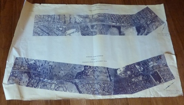
 Melton City Libraries
Map, Streets of Melton, 1963
MELTON’S STREETS Heritage Week 2014 What’s in a Name? Alphabetical List Aboriginal place names, Early Family Names and landowners, Agricultural, Shop and Commercial premises, Places and Events Melton & District Historical Society Street Naming Project 1972 – c 1998 Suburb Name – KURUNJANG - Kirkton, 1972, Brookfield, West, 1988 Melton and Town Centre - A joint collaboration with the Shire of Melton and Subdivision Developers ARNOLD Court – Family house - Arnolds Creek ALKEMADE Drive Family – Lime kilns Coimadia ALEXANDRA Street 1902 – Corination of King Edward VII and Queen Alexandra AVIATOR Place Event, location of plane crash – Jimmy Melrose 1936 Adina ?Annibee - Anniba? Agricultural Avon court .. .. BAKERY Square - Location of Jongebloed shop, bakehouse and stables BALUK Place Aboriginal BARLEYCORN Place Agricultural BILLING Place Name of Jimmy Melrose Uncle Noel Pemberton Billing BLACKWOOD Drive - Alexander Blackwood 1860c Registrar BARRIES Road C. E. Barrie “Darlingsford” farmer 1911, chaff mill owner BROOKLYN Road Staughton family residence. 1875 – Dismantled c 193? CAHILL Drive Family - Glenville Dairy CAMERON Court Family Canopus Place ? CANALLAN Drive Early Surveyor CAMPBELL Court Aviation – Melrose passenger 6th July 1936 CARBERRY Drive Michael, early landowner family CAREW Court Edward and Michael. Royal Hotel. Vera (Carew) Forran Singer - Opera CASEY Court Family CASHIN Court Family CHEVIOT Court Agriculture, breed of sheep CHESNEY Road was re named ( Minns Road being duplicated c 1973) CHRISTINA Crescent Christina McPherson, daughter of James and Mary Mary McPherson. Died 1955 aged 85 years COLLYER Close a deleted street (parallel to Yuille) re-used CORRIEDALE Road Breed of sheep CORR Court Teacher at first school, landowner CROXTON Court Name of the Hornbuckle and Knox family home DALEY Court - William Daley and family 1865 Bootmaker High Street DARLINGSFORD Boulevard - Name of early homestead Thomas B Darling 1853 DJERRIWARRH Court - Parish County of Bourke - very early map. DODEMAIDE Place Early land owners - Melton Football Team had 6 brothers playing c 1924 DONALD Court McPherson family 6 generations in Melton in 1936 DOUGAL Court DUNCAN Court .. .. DUNVEGAN Circuit Home of the McPherson family, castle Isle of Skye Name of bluestone house Smith Street (now at Willows) EMIL Court Jongebloed family EXELL Avenue Farming family Melton Sth- Closer Settlement 1907 EXFORD Road Exe former name of the Werribee river FARMER Court Name of early postmistress FERRIS Road John Ferris Farmer HANNAH Close First name of Hannah Watts – midwife HAYBALE Place Agricultural HELDER Court Early surveyor J Helder Wedge map HEWSON Street Winston Hewson Shire Engineer – check title c 1960 HENRY Street Township map c 1860 HESTON Street Heston Phoenix – C.J. Melrose plane HILDEGARDE Court Jimmy Melrose’s mothers name HOMESTEAD Close HORNBUCKLE Cres Farmers. Three members of family - Shire Presidents HURLEY Street Farmers IAIN Court Descendent of James and Mary McPherson JAMES MELROSE Drive Name appears on 2013 Melton information map JANG Place KURUN – jang KIRKTON Drive Name of the McPherson family home Toolern Vale Road KIRWIN Street Michael early landowners (deleted for freeway construction) KILPATRICKS Road Deleted when Barries Road was extended across Station Rd KOROROIT Court Early map, Parish of Kororoit. Creek name KNOX Circuit Family – Hornbuckle “Croxton Park” KURRUNJANG Drive Aboriginal name for people of the red earth – Suburb name Lara Place ? LLOYD Court Garage owners High Street. Laura lived to 100 years D 1955 LUBY Court John Luby – Crown Grant Land Title LITTLE Court MANNING Avenue Richard, hotel owner 1891 MARGARET Drive McPherson family McDONALD Street Melton South family name McKENZIE Street Township c1860 MORROW Street Early name MOWBRAY Crescent Name of English Melton, popularly believed origin of Melton MYERS Court Early setters c 1866 Crown Grant Land Title NIMMO Street Early name NIXON Street Name submitted by Mary nee Nixon Collins c1985 OLDERSHAW Road Early builder PALMERSTON Street Early township map c 1860 PEART Court Early name PENNYROYAL Avenue Plant growing by the creek. Early name used for the Toolern Toolam Creek PINKERTON Street Family name and early street map PINNACLE Crescent Agricultural - type of wheat PHOENIX Circuit C.J. Melrose Phoenix Heston Plane 2013 map PRATT Family PRIOR Court PYKE Place Brothers – early settlement 1838 RADFORD Court Land owners and business operators. Former Royal Hotel Grocer High Street demolished 1970 RAGLAN Court Hotel 19th century Lord Raglan RALEIGHS Road Oliver Reierson family (Norweigen) Shopkeeper – Dressmakers RIDDELL Drive (misspelt Riddle) Resident and land owner RODERICK Road McPherson family – a re occurring name ROLLAND Court Jones family ROSS Court Daniel. Landowner. Agnes Ross music teacher RUSSELL Court Robert. Early land surveyor of Melton 1853 RYAN Court Family early landowner. Member of the 1862 Road Board SHEBLER Place Augustus early Melton resident – Golden Fleece Hotel SHEEPFOLD Court Farming SHERWIN Court Sherwin Street earliest Township map– became Golf course SMITH Street Early township map. STRATHULLOH Circuit Strathtulloh Homestead. STAUGHTON Street Family – LARGE land owners Strachan ? SWANEY Court Marie Swaney earlier resident of Strathtulloh. SUTHERLAND Family name TOOLERN Street TOOLAM – TOOLERN Creek TULLIDGE St Road marked on 1861 map UNITT Street Early Township c 1860 WALLACE Square Cr Jack Wallace 5 terms as President 46 years unopposed WATTS Court Hannah Watts – midwife, cottage hospital WALSINGHAM Name of house of Minns family. From Walsingham Norfolk England WESTLEY Place Name of Jimmy Melrose Percival Gull Plane WESTLAKE Drive Early resident WHICKHAM Street Family Name Melton South WILSON Road Albert, Melton South YUILLE Street William Cross, early landowner, Rockbank run Zoomed in section of Melton Streets including Church and High Streetlandscapes of significance -
 Eltham District Historical Society Inc
Photograph - Digital Photograph, Alan King, St Margaret's Anglican Church, Pitt Street, Eltham, 30 January 2008
St Margaret’s Church of England was officially opened on December 12, 1861. It is the oldest intact church building in Eltham. At the time it was known as Christ Church until its consecration in 1871, when it was completely free of debt (£1,700 for the church and parsonage) despite the district’s poverty. This was largely due to the free labour and materials, including locally made bricks donated by local artisans and others. The church is historically significant because it is the oldest church in the former Shire of Eltham and has associations with the philanthropist and founder of Brighton, Henry Dendy (who donated the land on which the church is built), the architect Nathaniel Billing and the prominent local builder, George Stebbing. The church is architecturally and aesthetically significant because it is constructed in the Gothic Revival style with several stained-glass windows of various dates and is also a very early use of polychromatic brickwork in Victoria. Billing was one of the first Melbourne architects to employ polychromatic brickwork and an important early architect. The rear wall was intended to be temporary. A major feature of the design is the large buttresses with long, steeply graded upper faces. The overall design is well proportioned with the surface brick patterns relieving an otherwise austere design. The church is spiritually and socially significant because it has been an important place of worship for the people of Eltham for almost 150 years. The land on which the buildings stand was donated by Henry Dendy. Dendy arrived in Melbourne in 1841 after purchasing in England eight square miles at Brighton under the system of "special surveys". After this land passed out of his hands, Dendy moved about Victoria, visited England, then returned to settle in Eltham where he purchased a flour mill. Dendy chaired the meeting held in 1860 “for the purpose of devising such means as may be expedient for the establishment of a Church of England in the township of Eltham”. He became chairman and treasurer of the church committee. Unlike the establishment of many early churches in Victoria where a vicar was appointed to a parish and later a permanent church was constructed, the population at Eltham initiated action to build a church. The nearest church at that time was at Heidelberg and the Eltham settlement was part of the parish of St Johns Heidelberg. Isolation and the tedious, time consuming journey between Heidelberg and Eltham resulted in the Eltham community taking its own action. The original vicarage (Dendy House) at the rear of the church is also an important part of the cultural significance of this place because it is connected to the church and the development of the Eltham area. Together, the church and the vicarage are aesthetically significant because they form a significant streetscape feature. The mud-brick community hall designed by Robert Marshall was added in 1978. In 2014 the original temporary rear wall was removed as part of a modern extension designed by Architects Atelier Wagner and constructed by Conrad Construction and Management. Covered under Heritage Overlay, Nillumbik Planning Scheme. National Trust of Australia (Victoria) State significance Victorian Heritage Published: Nillumbik Now and Then / Marguerite Marshall 2008; photographs Alan King with Marguerite Marshall.; p67 St Margaret’s Anglican Church in Pitt Street, Eltham, which officially opened on December 12, 1861, is the oldest intact church building in Eltham.1 With the nearby courthouse and police station, it was one of the first permanent community buildings in the district. The church and vicarage are on the Register of the Heritage Council of Victoria and the National Trust of Australia – Victoria. The church is important as an early example of polychrome brickwork by the notable architect Nathaniel Billings. It is also notable for its historic associations with the early settlement of the Shire of Eltham and its connection with Henry Dendy, Brighton’s founder.2 Henry Dendy, who lived in Eltham much longer than at Brighton, chaired the original meeting which planned the church, and he donated the half-acre (0.2ha) site. Dendy had arrived in Melbourne in 1841 after buying eight square miles (20.7sq km) at Brighton while in England. After this land passed out of his hands, he eventually settled in Eltham where he bought a flour mill, west from the corner of Main Road and Pitt Street (then called Brewery Lane). The vicarage was named Dendy House after him. The Eltham settlers were unusual in initiating the establishment of a church. Usually in Victoria a vicar was appointed to a parish and then a permanent church was constructed. But then, the nearest church was at Heidelberg, which was a tedious and time-consuming journey. St Margaret’s builder was a local, George Stebbing, who also constructed the former Methodist, later Uniting, Church at John Street and the Shillinglaw Cottage near Eltham’s Central Park. It is believed the first Anglican Bishop of Melbourne, Bishop Perry, dedicated the church. After the ceremony he joined in the festivities at the nearby pub and a bill was sent to the parish for teas taken there by the bishop with other participants. The first vicar was the Reverend Robert Mackie from 1864 to1866. St Margaret’s Church was originally called Christ Church until its consecration in 1871, when it was completely free of debt (£1700 pounds for the church and parsonage) despite the district’s poverty. This was largely due to the free labour and materials, including local bricks, donated by local artisans and others. St Margaret’s Church is in the Gothic Revival tradition with a buttressed nave, paired lancet windows, porch and bell-cote. It was the first polychromatic brick church in Australia, using softly contrasting coloured brickwork.3 Billing was one of the first architects to introduce polychrome brickwork into Melbourne. His original drawings for St Margaret’s survive in a folio of his architectural work. However the church’s brickwork is more subdued than in his drawings. About half the windows – those in clear glass with gold borders – are original. The stained glass windows were made much later, but the one behind the altar is thought to be the oldest in the Diamond Valley. It was to be temporary until the congregation could afford to extend the church. In the early 1960s the original cedar pews were replaced by blonde timber pews and the originals were sold to restaurants and to private individuals. Eminent local sculptor Matcham Skipper created a crucifix for the church. A major addition was made in 1978, when the weatherboard hall was replaced by a mud-brick hall. Made of local material, it was designed by local architect and a former shire president Robert Marshall. The mud-brick hall reflects the style of building in Eltham of the late 1970s and for which Eltham is well-known. Perhaps because its earthy tones blend with the surrounding environment, the hall sits well with the church building. St Margaret’s membership has included economist and ABC chairman, Richard Downing; political commentator, diplomat and academic, William Macmahon Ball; Eltham civic leader, Charles Wingrove; artist, Peter Glass; and Eltham’s first postmaster, Frederick Falkiner.This collection of almost 130 photos about places and people within the Shire of Nillumbik, an urban and rural municipality in Melbourne's north, contributes to an understanding of the history of the Shire. Published in 2008 immediately prior to the Black Saturday bushfires of February 7, 2009, it documents sites that were impacted, and in some cases destroyed by the fires. It includes photographs taken especially for the publication, creating a unique time capsule representing the Shire in the early 21st century. It remains the most recent comprehenesive publication devoted to the Shire's history connecting local residents to the past. nillumbik now and then (marshall-king) collection, eltham, st margaret's anglican church, st margaret's church, st margarets church hall, christ church -
 Eltham District Historical Society Inc
Photograph - Digital Photograph, Marguerite Marshall, St John's Anglican Church, Diamond Creek, 7 September 2008
The building was designed by Charles Maplestone of Heidelberg, son-in-law to Anthony Beale of St Helena. Maplestone was a prominent architect who came out to Australia with his family in 1852. The foundation stone was laid by Mrs Isabella Maplestone on 11th November 1867. The bricklayers for the church were George Stebbing, H Limmer, H Spicer and a Mr Timm while Thomas Day was the stonemason. Another three years were to pass before sufficient money could be raised for its completion. It was opened by Bishop Perry on 1st November, 1870. The church bell which hung under a tree for 50 years until it was incorporated in the parish hall was brought out from England and presented by Charles Orme. In 1916, the estate of George Martin Pizzey left sufficient money to build the red brick hall, which still stands today (2023) though in January 1969 the hall and bell tower were badly damaged by bushfire. Coincidentally the former home of benefactor, George Pizzey was destroyed in the same fire. Of particular significance are the interior and exterior of the church, the Sunday school and hall with emphasis on pre-World War I fabric (excluding the 1990s additions) and the three coloured glass windows currently suspended in the 1990s entry foyer. In 2011 further alterations were made to the front of the Church. The church is historically significant because it was the oldest public building in the former Diamond Valley Shire, is amongst the oldest buildings in the Shire of Nillumbik and is associated with the early settlement of the Diamond Creek district. The church is historically, socially and spiritually significant because it has been a place of worship for over 150 years and continues to be, an important meeting place in the Shire. The church is aesthetically significant for the three stained glass windows executed by the noted stained glass manufacturers, Ferguson & Urie, as well as the supporting coloured glass windows in the church. The Sunday school & parish hall is architecturally significant because the hall is a well executed and preserved example of the work of noted church architects, North & Williams. It is historically significant because it is connected with local parishioner and Melbourne industrialist, George Pizzey, who bequeathed funds for its construction. Covered under Heritage Overlay, Nillumbik Planning Scheme. National Estate Ntionl Trust of Australia (Victoria) Local significance Published: Nillumbik Now and Then / Marguerite Marshall 2008; photographs Alan King with Marguerite Marshall.; p85 St John’s Anglican Church stands like a beacon on the hill on Main Street, Diamond Creek. Today the church has a large congregation, but its early years were marked by a small congregation struggling to find enough money to survive. It was gold in Diamond Creek that resulted in the building of this National Trust registered property.1 This church is far removed from William Wilson’s humble barn (later the Bowling Green) where the first Anglican church services were conducted – probably the first in the district.2 In the mid 19th century services were infrequent as the Rev Francis Hales, travelling on horseback, also conducted services elsewhere, including at Heidelberg, Coburg, Kinglake, Arthurs Creek, St Andrews and Kangaroo Ground. In 1860 Diamond Creek came under the jurisdiction of the Eltham Parish. Until the mid 1860s the Diamond Creek settlement included only about 20 families who were struggling farmers. But this changed when gold was found in 1862. Then the township grew to 200 families, including miners, civil administration workers and shopkeepers. The resulting growth of Church of England adherents prompted them to petition the Government in 1866 for land to build a church. The area chosen, on which the original building still stands, was at the centre of the proposed township. Today church leaders believe that this conspicuous location is one of the reasons for its exceptional growth. Prominent architect Charles Maplestone designed the building as he did the Presbyterian Church at Kangaroo Ground. St John’s, which is still intact, was built in the Gothic Revival style with the traditional rectangular plan of a central nave and sanctuary at the end. It is typical of small churches built in Victoria at that time, with polychromatic hand-made bricks, a porch, diagonal buttresses and a slate roof.3 The church was officially opened by Lord Bishop Perry on November 1, 1870. But during the next 40 years, due to the varying fortunes of gold mining, the church struggled to remain viable. In 1909 it separated from the Eltham Parish to form a parish with Greensborough. Life became more difficult with the privations of World War One. Then disaster struck in 1915 when fire destroyed the Diamond Creek Gold Mine, wiping out the major livelihood of most parishioners. However the church’s morale was lifted in 1916, when it received a bequest to build the red brick hall, from late parishioner and prominent leather manufacturer, George Pizzey. As prosperity grew, in 1924 the congregation separated from Greensborough, but they rejoined in the 1930s Depression. In the 1950s the wider population soared, impacting on St John’s, and it became a separate parish, becoming responsible for six churches at St Andrews, Hazel Glen, Hurstbridge, St Helena and Yarrambat. As parishioner numbers outgrew the building, extensions were added in 1989 and then in 1993, blending in well with the original building. Church members have made a huge contribution to the local community. John Ryan was a Heidelberg Shire Councillor for 25 years from 1931, Mayor in 1939 and headed several local sporting and other organisations. His son Jock became a clergyman and a local historian heading the Nillumbik Historical Society. Another parishioner, Dr Ted Cordner, came to Diamond Creek in 1920. One of his sons Donald, who was a local doctor, won the Brownlow Medal, was President of the Melbourne Cricket Club and President of the Melbourne Grammar School Council. Roy ‘Monty’ Vale was a state Liberal MP and was related to May Vale, a member of the Heidelberg School of Artists.4 In the early 21st century St John’s Anglican Church is one of the fastest growing congregations in Melbourne. References: St Johns Anglican Church complex, Sunday School and Parish Hall 61 Main Street DIAMOND CREEK, NILLUMBIK SHIRE. (2023, June 7). Retrieved from https://vhd.heritagecouncil.vic.gov.au/places/64023 Diamond Creek, VIC. – St John’s Anglican (2023, June 7). Retrieved from https://www.churchhistories.net.au/church-catalog/diamond-creek-vic-st-johns-anglican This collection of almost 130 photos about places and people within the Shire of Nillumbik, an urban and rural municipality in Melbourne's north, contributes to an understanding of the history of the Shire. Published in 2008 immediately prior to the Black Saturday bushfires of February 7, 2009, it documents sites that were impacted, and in some cases destroyed by the fires. It includes photographs taken especially for the publication, creating a unique time capsule representing the Shire in the early 21st century. It remains the most recent comprehenesive publication devoted to the Shire's history connecting local residents to the past. nillumbik now and then (marshall-king) collection, st john's anglican church, diamond creek -
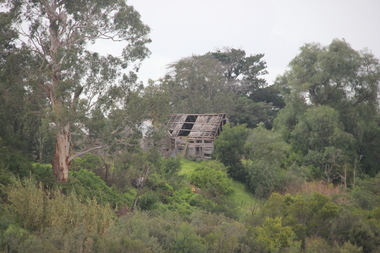 Ballarat Heritage Services
Photograph - Photograph - Colour, Lisa Gervasoni, Remains of Angus McMillan's Bushy Park Home, 2014, 07/06/2014
Angus McMillan was born in 1810 at Glenbrittle in the Isle of Skye. He was one of fourteens sons of Ewan McMillan. Angus McMillan arried i New South Wales in January 1839, and became an overseer for Captai nLachlan Macalister. I n 1839 Angus McMillan travelled south. He settled for a time on Jame MacFarlane's statin at Currawong. IOn 28 May 1839 Angus MacMillan stated travelling southward toward the coast. Angus Macmillan named the Avon River after the river of the same name in his native Scotland. In 1840 he established a pastoral run at Bushy Park, near Maffra. William Odell Raymond established a run in the area in 1842, and built his house, Strathfieldsaye, during 1848–54. European settlement did not take place without resistance, and in return, massacres were inflicted by Angus McMillan and others on Gunai people, especially between the years of 1840 and 1850. (wikipedia) The first application for the 'Bushy Park' run appears in the “Port Phillip Gazette” on 13 August 1843. It was taken up by Angus McMillan, who also took up the 'Boisdale' run for his employer Lachlan Macalister at the same time. In March 1844 a Licence to occupy the 16,000 acre 'Bushy Park' was granted to McMillan. In the late 1840s Andrew Martin and Matt McCraw built Angus McMillan's Bushy Park homestead. Aboriginal killings in Gippsland area most often were never formally recorded, but lived on in folklore, mainly in place names pinpointing what some historians now refer to as "massacres", and others as "conflicts". There is Boney Point, on Lake Wellington, Butchers Creek, near Metung, Slaughterhouse Gully, at Buchan, Skull Creek, at Lindenow, and, notoriously, Warrigal Creek, at Woodside. "Here, according to a couple of contemporary - though not eyewitness - reports, between 50 and 150 blacks were killed in an orgy of revenge after the murder and mutilation of a leading Scots settler, Ronald Macalister. If anybody had any doubts about the fitness of commemorating McMillan's name, no one voiced them then. Gippsland was, and still is, dotted with stone cairns tracing his route from Omeo, down the Tambo Valley to the fertile plains where he was to make (and lose) his fortune. And where, according to a growing body of opinion, he was to lead the "Highland Brigade", a band of armed settlers, against the Kurnai. History is fiction agreed on, and it is written by the winners. For most of the past 150 years, McMillan has been hailed as a trail-blazing pioneer. The legend began to crumble 20 years ago with publication of new histories, which at first outraged Gippsland historical societies and old residents, but which have gradually changed the way McMillan is viewed. ... Still, not all McMillan's contemporaries agreed with the "Highland Brigade" and its methods. Henry Meyrick, an English-born squatter, wrote to relatives in disgust about his neighbours. He estimated that 450 had been killed, and wrote: "Men, women and children are shot down whenever they can be met with. Some excuse might be found for shooting the men by those who are daily getting their cattle speared, but what they can urge in their excuse who shoot the women and children I cannot conceive." (http://www.theage.com.au/articles/2002/04/26/1019441303552.html, accessed 20 September 2016.) The Gippsland electorate is called 'McMillan' in his honour. Photographs of the remains of a timber home used by squatter Angus McMillan at his "Bushy Park" property on the Avon River. angus mcmillan, bushy park, avon river, squater -
Glen Eira Historical Society
Book - Robertson, Alexander William
... Settlements ...Contains one item about 'Labassa', called 'Ontario' when owned by Alexander William Robertson: 1/One copy of a thirty-two page colour book, published by the Friends of Labassa and The National Trust in 2004. The book details the history of Labassa (and its owners) as a place for social gatherings and entertaining of Melbourne society of the late nineteenth century, and its letter use as flats and a boarding house. Extensively illustrated with colour photographs, architectural sketches and plans, the book LABASSA: A GRAND VICTORIAN MANSION details Labassa’s architectural significance Please refer to file 1113Y for the other copy of this book. For further information about Labrassa please refer to file 1113.labassa, ontario, sylliott hill, caulfield north, friends of labassa, manor grove, national trust of australia (victoria), balaclava road, orrong road, caulfield, mansions, cobb and co., amatil ltd. (limited), alcoa of australia ltd. (limited), lyall william, mickle john, billing richard annesley judge, robertson alexander william, watson john boyd ii, koch john augustus bernard, hammond victoria, palmer lee, davis kingsley, groenhout chris, worrall bronwyn, balderstone sue, biarujia ian, cassidy darien, davidson rodney ao obe, forge warwick, lewis miles dr., sagazio celestina dr., billing mary, billing williamina, billing richard junior, watson flora kate, robertson eva, robertson nina, robertson emily, robertson john, australian-german association, bicentennial gift to the nation, ferguson and urie, crouch and wilson, tangent design, midas printing (asia) limited (ltd), flats, architectural features, architectural styles, auctions, land sales, land subdivision, architects, lawyers, judges, coaches and carriages, businesspeople, german community, victorian style, grants, voluntary workers, property development, construction (events and activities), gold mining, theatrical productions, stairs, stained glass, settlements, graziers, verandas, cast iron work, marble, balconies, bell towers, towers, bay windows, panoramic views, bedrooms, servants quarters, billiards rooms, rooms, fireplaces, sculpture, servants, marvellous melbourne, land use, depression 1890s, photography, photographers, entrance hall, domestic life, cultural events and activities -
 Flagstaff Hill Maritime Museum and Village
Vehicle - Tip Dray, Prior to 1930s
A Dray is a type of dead axle wagon that was used to transport heavy loads or objects. They had a flat level floor and while some had no sides, others had box bodies and sides. Tip Drays (also known as Tip Carts, Muck Cart, Scotch Cart, Tumbrel or Putt in different parts of England) were smaller than other drays as their loads were heavy and usually only pulled by one horse. Their basic design included two wheels, a tipping body and shafts. The Tip Dray has a unique mechanism that allows the top to tip backwards to tip the load out of the back of the dray. The tipper was activated by a handle at the front allowing the driver to operate it while still having control over the horse. A Tip Dray was an indispensable piece of equipment in the days before tractors and mechanical trucks. They were used by farmers and carters to transport hay, rocks, bricks, gravel and rubbish etc. and because they were useful for dumping loads, they were favoured for use in road and railway construction. A photo in the collection of the Lorne Historical Society shows a tipping dray being used during the construction of the Great Ocean Road. They were part of the daily street traffic in towns and cities around Australia from the early days of settlement. In Australia in the early 1900's, carters began to join unions to protect their jobs and pay. N.S.W. had a "Trolley, Draymen and Carters Union", Queensland had a "Tip Dray Men's Association" and in W. A. the "Top Dray Driver's Union" had a "cessation of work" in 1911 when they were fighting for an increase in their day's wages. In 1910 a meeting of Tip Carters was held in Geelong at the Trades Hall to discuss the formation of a union (The Geelong Tip Dray Carters) which was a success and a schedule of rates for all carting, whether by contract or day labor, was fixed. By 1912 they had "labelled" more than 50 drays and had representatives on the "Trades Hall and Eight Hours Committee". By the mid 1930's and early 1940's, tip drays were being superseded by mechanical trucks and utes. However tip drays continued to be used in some circumstances. They were a practical solution to the problem of petrol rationing during W. W. 2. It was noted in a letter to the editor in the "Sunshine Advocate" in 1938 that a positive argument for continued use of Tip Drays for rubbish collection related to the idea that a horse drawn vehicle involved with lots of stops and starts at different houses (very like a milkman's delivery route) often involved the horse "driving itself" while the driver picked up the rubbish - something a motor truck was unable to do! Another article written in August 1935 and published in the Age in a parliamentary report into the rubber industry noted "tip drays had almost disappeared and in their place, metal was carted in 5 ton motor trucks" but the report went on to say that as a part of the Government relief work (during the Great Depression) the Government had "to some extent reintroduced the tip drays so that a greater number of men would be employed". This particular tip dray was owned by Mr. Oswald (Jack) Bourke. He used it to deliver dry goods from Sunbury to the Queen Victoria Market in Melbourne several times a week in the 1930's and then (between 1945 and 1962) Mr. Bourke used it on the garbage round in Springvale Victoria for the Springvale Council. The Council owned three drays and the "No. 3" painted on this dray is in recognition of its original number. After the death of Mr. Bourke in 1990, one of Mr. Bourke's sons (Andy) found the dray in a shed and restored it. The sign writing on the back and side panels were added during the restoration. This Tipping Dray is a significant example of a horse drawn vehicle that was used by workers from the early days of white settlement through to the 1940's and even into the early 1960's. It was used in a range of "working class" occupations - road construction, railway construction, carting goods, rubbish collection etc. and would have been found in cities, country towns and on farms.A wooden and metal tipping dray with a box body and four sides. It has two iron and wooden wheels (with 14 spokes), two wooden shafts and a metal tipping mechanism. The back panel folds down to allow loads to be dumped out. It is painted in green and cream with sign writing on one of the sides and on the front and back panels. It features decorative painted lines and designs in burgundy, cream and light blue on most of the wooden parts. The tipping mechanism is on the front of the dray's left side and consists of a metal pin secured with a metal ring, and a lever.Front of dray - "No. 3" Side of dray - "A. & M. BOURKE / Contractors / LONGWARRY" Back of dray - "G.T. ANDREWS / QUEEN VICTORIA MARKET - Stand C23 / Phone DANDENONG 225"flagstaff hill maritime museum and village, warrnambool, shipwreck coast, tipping dray, dray, tip dray, tip cart, vehicles, horse drawn vehicle, springvale council, jack bourke, muck cart, scotch cart, tumbrel, putt, box body, oswald bourke, sunbury, queen victoria market, melbourne, no. 3