Showing 2430 items matching "orcharding"
-
 University of Melbourne, Burnley Campus Archives
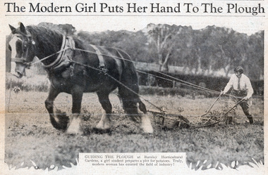
Newspaper - Newspaper Cutting, The Sun News-Pictorial, The Modern Girl Puts Her Hand To The Plough, 1930
Newspaper cutting with 3 photos (2 copies) from "The Sun News-Pictorial", October 15, 1930. (1) Student ploughing with a cart horse, with the caption: "Guiding the plough at Burnley Horticultural Gardens, a girl student prepares a plot for potatoes. Truly, the modern woman has entered the field of industry!" "Happy students at Burnley Horticultural Gardens thoroughly enjoy the hard work associated with the assimilation of farming and gardening lore. Ploughing, planting, pruning, and all the multitude of tasks in horticulture, come within the practical range of their studies." (2) 5 students walking in formation, with the caption: " A bevy of girls returning to lunch after their morning's work yesterday." and Two students in the orchard with flowering fruit trees, with the caption: "Examining the apple blossom for the implacable foe of the orchardist - thrip. The gardens are kept singularly free of pests."the sun news-pictorial, burnley horticultural college, students, female students, ploughing, horses, students working outside, orchard, apple blossom, thrip, draught horses, potatoes -
 City of Moorabbin Historical Society (Operating the Box Cottage Museum)
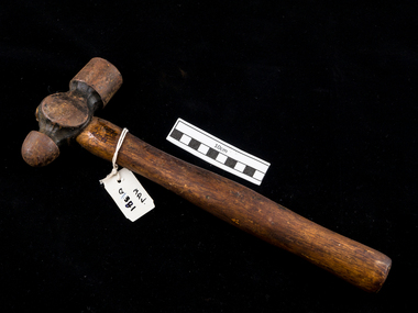
Tool - Hammer, Ball & Peen , metal wood c1900, c1900
Among the early settlers in Moorabbin Shire were blacksmiths who made tools for the other settlers who were establishing the homes, market gardens, farms, orchards and various businesses. Early settlers were self reliant and repaired their own equipment for kitchen,dairy, farm, horses, carts using various tools . Besides for peening (surface hardening by impact), the ball-peen hammer is useful for many tasks, such as striking punches and chisels - usually performed with the flat face of the hammer. The peening face is useful for rounding off edges of metal pins and fasteners, such as rivets. The ball face of the hammer can also be used to make gaskets for mating surfaces. A suitable gasket material is held over the surface where a corresponding gasket is desired, and the operator will lightly tap around the edges of the mating surface to perforate the gasket materialThis hammer is typical of the type used by early settlers in Moorabbin Shire c1900A hard faced ball & peen hammer, also known as a machinist's hammer,[ is a type of peening hammer used in metalworking. It has two heads, one flat and the other, called the peen, rounded.early settlers, market gardeners, blacksmiths, tools, building equipment, hammers, moorabbin shire, bentleigh, mckinnon, highett, cheltenham,mcewan james pty ltd, melbourne, bunnings pty ltd, -
 Surrey Hills Historical Society Collection
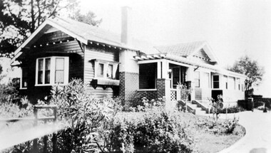
Photograph, 'Strathmore' 75 Victoria Crescent, Mont Albert
‘Strathmore’ Victoria Crescent (dem.) Joseph Sutton Crow and his wife Jessie (nee Temby) bought this property which had belonged to the Purbrick family in 1924. Sutton was an amateur ‘planner and landscape designer’ and had much pleasure in planning the use of their garden of 100 feet by 400 feet. While part remained rural with sheep, an orchard and vegetable garden, he laid out sweeping designs for the front garden which Jessie enjoyed converting into a garden worthy of display and which did gain prizes in the Herald Garden competitions of the 1930s. They entertained friends and often had as guests University Conservatorium staff and visiting musical personnel. They also opened the garden for local church fund-raising functions. Children, Jean and Ray, had areas set out for their recreation with pets and activities areas. The donor was their daughter. A black and white photograph of a Californian Style weatherboard house, painted in a dark colour. There is a well established garden in front. There is a bay window at one side of the house.house names, californian bungalow style, weatherboard, victoria crescent, surrey hills, (mr) joseph sutton crow, (mrs) jessie sutton crow, purbrick family, 1924, herald garden competitions, 1930-1939, (miss) jean sutton crow, (mr) ray sutton crow, 'strathmore' -
 The Beechworth Burke Museum
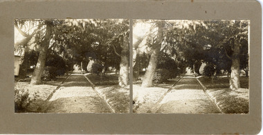
Photograph - Stereoscopic Photograph, c1900
The gardens of Ovens District Hospital were laid out and planted by R H Jenkyns in 1874. Over 200 species of trees and shrubs were planted, including several large Himalayan Cedars (Cedrus deodora), a Coast Redwood (Sequoia sempervirens), rare Scots Pine (Pinus sylvestris), Pencil Cedar (Juniperus virginiana), Bunya Bunya Pines (Araucaria bidwillii), a Purple-leaved Dutch Elm (Ulmus x hollandica 'Purpurascens'), American Ash (Fraxinus americana), Pinus radiata, and numerous Populus alba trees and suckers. The gardens were considered integral to the healing process, also including orchards and kitchen gardens. In the 1880s, tourists flocked to Beechworth as the area became recognised as a health resort and picturesque beauty spot. Although the hospital closed in 1940, and parts were subsequently demolished, the gardens remain and form part of the site's listing on the Victorian Heritage Register. This photograph is part of a collection of items held by the Burke Museum relating to Ovens District Hospital. At the time of being built, the Ovens District Hospital was the only hospital between Melbourne, Victoria, and Goulburn, New South Wales, treating patients from all of north-east Victoria, including Indigo Shire.Black and white stereoscopic photograph mounted on card.Reverse: 97-2292 / View up centre path of Hospital / A03177 / BMM3177 / Note: A03178 / View of the central path of the Ovens Hospital / (Church St) Beechworthovens hospital, hospital garden, gardens and parks, ovens district hospital -
 University of Melbourne, Burnley Campus Archives
Photograph - Colour and black and white photocopy and document, The Egg and Poultry Producer, The Macauley Family, 1872-2013
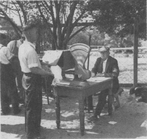
History and reminiscences with photocopied photographs and a newspaper article about the family and life at Burnley as children. John Macauley and son, Bill, lived at Burnley 1914-1972. History and reminiscences with photocopied photographs and a newspaper article about the family and life at Burnley as children. John Macauley and son, Bill, lived at Burnley 1914-1972. Egg Curators. (1) p.3(b) "Weigh-in at start of new Egg Laying Competition, c. 1940 with Bill and father John T. Macauley." (2) p.5(c) "P.R.L. 1960." Plant Research Laboratory. (3) p.5(d) "Path leading to Plant Breeding Plots. 1960." (4) p.7(a) 1959." (5) p.7(b) "Drive-Burnley Gardens 1949." (6) p.7(c) "Seed Testing Laboratory built 1966." (7) p.9 "1990's." Probably a bit earlier. (8) p.9 "2013." Actually pre 1991. (9) p.9 "Averil and Esmerelda 1959." (10) p.11(b) "1960 view showing 6 hen pens of Random Sample Laying Test. Residence (built 1960) at rear." (11) p.12(a) "1959 view of potting-shed/glasshouse on way to orchard." Note cactus collection. (12) p.12(b) "1960 view of 'Hydrangea Walk'-orchard fence on left." (13) p.12(c) "2013 view of path leading to the above pathway." (Hydrangea Walk.) (14) p.14 "Burnley Gardens Kneens house at rear 'Jack' 1960's." (16) p.14 "Horticultural College c.1967." (17) "The 'family' tree re-visited by Janice & Alison Downman Dec 1995." (18) Newspaper article, "Bill Macauley leaves the birds," from "The Egg and Poultry Producer" August 1972.family life, burnley, children, john macauley, bill macauley, egg curators, egg laying competition, plant research laboratory, janice downman (née macauley) -
 University of Melbourne, Burnley Campus Archives
Album - Black and white prints and negatives, James Leslie Provan, Photograph Collection, 1940-1950
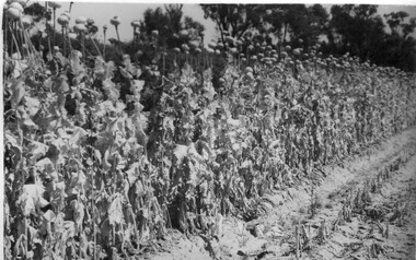
Collection of 39 black and white photographs. Some photographs with handwritten annotations in what looks like the handwriting of J.L. Provan. Mostly at Burnley, some at Moorabbin. (1) "Opium Poppy 1942 Burnley. Publicity Branch Department of Agriculture." Negative in envelope marked, "Prints 1 of No. 398 Department of Agriculture 'McP.' " (2) Grape vine and cabbages. (3) Rows of seedlings in the Orchard. (4) Orange tree? unpruned. (5) Flowers. (6) "Double and single rows of French Beans." (7) "Sage & marjoram." (8) Hydrangeas. (9)Sprinkler on newly planted cabbages. (10a)"Lettuce Iceberg 1/1/43." Seeds on soil surface. (10b) "Lettuce Iceberg 1/1/43." Seedlings emerging. (11)? planted in terracotta pipes. (12) Rows of seedlings in the Orchard. (13) "A student sowing Parsnip seed in a drill row. School of Horticulture Burnley Gardens." (14) Student distributing fertilizer? (15) Similar. (16) Similar. (17a) Flowers. (17b) Flowers. (18)"Beetroot Crimson Globe." (19) A seed drill. (20)Canna. (21a) Vegetable rows. (21b) ? (22) Student hoeing. (23) Student hoeing. (24) Similar. (26) "Cabbage Burbees Allhead 2/2/43," seedlings. (27) Water, manure, etc. (28) "Celery beds Ray Marriott Moorabbin April 2nd 1943." (29-37) Also at Moorabbin probably: (29) Vegetables. (30) Onions. (31) Vegetables. (32) Planting seedlings. (33) Vegetables. (34) Celery, carrots, turnips on display. (35) Carrots growing and just pulled up. (36) Peas. (37) Ploughing with horse. (38) Student spraying vegetables at Burnley. (39) House?j.l. provan, burnley, moorabbin, opium poppy, grape vine, cabbages, seedlings, orchards, orange trees, flowers, french beans, sage, marjoram, hydrangea, sprinkler, lettuce iceberg, seeds, students sowing, parsnips, school of horticulture burnley gardens, beetroot, hoeing, water, manure, celery, vegetables beds, ray marriott, onions, carrots, turnips, peas, ploughing, horse, spraying -
 University of Melbourne, Burnley Campus Archives
Album - Colour slides, Burnley Views, 1956-1969
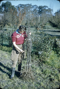
Contributor: T.H. KneenBox of 47 slides, some labelled. (1) "Marjorie Hall 1st Year Student June '56 No. 1872." Working with fruit tree stock. (2) "Orchard June 1956 No. 1710." 2 men and a tractor.(3) "Camp 1957." Wilson's Promontory. (4) View of Drive No. 1677." C. 1958 (5) "GenView No. 1771." (6) "Burnley Gardens Entrance 4.4.58 N0. 1672." (7) "Wilson's Promontory Lilly Pilly Gully Nov 1960." (8) Dec '62." (9) "Dec '62." Kneen child. (10) Luffmann Ponds "Aut. 1962." (11) Grevillea Sep 1963. (12) Sep 1963.Reflection of Crack Willow in Luffmann Ponds. (13) Sep 1963. Orchard blossom. (14) View of Administration Building at sunset Aug 1964. (15) Rose 'Heat Wave.' May 1965. (16) Kneen child sitting under a tree May 1966. (17) 'Department of Agriculture Burnley Gardens' sign May 1966. (18) Administration Building May 1966. (19) Plant Science Block May 1966. ((20) Wintersweet August 1966.(Actually appears to be Witch Hazel Hamamelis mollis.) (21) Student on tractor in the Orchard October 1966. (22) Garden view, view of Principal's Residence through blossom trees October 1966. (23) Students walking through the Gardens October 1966. (24) "Leaf Cuttings Rex begonia 2 October 1966. (25) Emily Gibson beds October 1966. (26) Principal's Residence in a garden view October 1966. (27) Garden view looking towards the Principal's Residence and the Shady Garden October 1966. (28) Drive looking towards the Administration Building from the Plant Research Institute. (29) Kneen child (not Burnley?) (30) Unveiling of Burnley Horticultural College plaque commemorating 75 years, 1891-1966 - Eric Littlejohn, ?, T.H. Kneen. Includes key to Pavilion 1969. (31) "Rose Pruning Demo - Canteen." July 1969. (32, 33) "Rose Pruning Demo 1969." July 1969. (34) "Plant Science Block & College." July 1969. (35) Plant Science Block 6/69." July 1969. (36) "Burnley Gardens 6/69." looking towards Dairy and Yarra Boulevard (37) "Pond No. 1717." (38) "Pond 1748." Kneen children playing by the Luffmann Ponds, Oak tree behind.. (39) Ginkgo leaves June 1967. (42) ? (43) Erithyna caffra in flower (removed 2016) December 1966. ((44) Administration Building and Nursery from PRI." (45) Pelargoniums. (46) Azalea mollis (47) Pelargonium foreground, geranium background.marjorie hall, students, fruit trees, orchard, tractor, wilson's promontory, burnley gardens, entrance, drive, garden view, luffmann ponds, grevillea, rose, kneen family, sign, wintersweet, plant science block, administration building, students working outside, principals residence, plaque, rose pruning demonstrations, ginkgo, pelargoniums, erythryna -
 Mt Dandenong & District Historical Society Inc.
Photograph, View Over Roof of "Kalorama"
Taken in 1908, this photograph, though rather blurry, gives an indication of the location of the early settler properties in the valley in relation to one another. European trees have been planted at 'Kalorama' , the first home of Ellis Jeeves. John Lundy-Clarke grew up in the Kalorama/Mt Dandenong area and later in life (1972-74) began to write a comprehensive history of the area working from an original settlement map in an effort to cover all areas.Black and white photograph looking across hillside with large trees and rooftops visible. Handwritten description on reverse by John Lundy-Clarke.1908 View over roof of “Kalorama” towards the Falls. Paynter’s house on LOT 29 in low centre (now “Yosemite”). Pimms house on LOT 19 above Paynters and beyond scrub. Logan’s house faint above left of “Kalorama”. Dunbar’s LOT 20 beyond Pimm’s orchard. Gum trees on right were on Price’s LOT 19 now Tosari Rd area. It was one of these that figured in the episode of the runaway log in 1930. It leaped in one bound over Barbers Road at bottom of scrub in centre of picture then over Logan’s house.kalorama, ellis jeeves, jeeves -
 The Beechworth Burke Museum
Audio - Oral History, Jennifer Williams, Mr Harry Mason, 13th April 2000
Mr Harry Mason was born in Stanley, Victoria, on the 23rd of July 1925, attending the primary school in Stanley and high school in Beechworth on the mail truck. His family initially moved to the area during the initial Gold Rush period. He moved to Beechworth in 1960. For seven years after school, he worked in the local orchard full time before becoming the local gravedigger, responsible for digging the graves of Beechworth residents and Asylum for 23 years. This oral history recording was part of a project conducted by Jennifer Williams in the year 2000 to capture the everyday life and struggles in Beechworth during the twentieth century. This project involved recording seventy oral histories on cassette tapes of local Beechworth residents which were then published in a book titled: Listen to what they say: voices of twentieth-century Beechworth. These cassette tapes were digitised in July 2021 with funds made available by the Friends of the Burke.Mr Harry Mason's account of his life in Beechworth and the local area during the 20th century is historically and socially significant to the cultural heritage of the region. He details important historical events and hardships in the region's history that had a lasting local, regional and national impact, including Australia during war time, economic struggles, and women's societal roles in a rural area. Mr Mason also discusses agricultural and gravedigging practices of the time as well as what it was like growing up in rural Australia. This first-hand account is imperative to our understanding of life during the last century. This oral history account is socially and historically significant as it is a part of a broader collection of interviews conducted by Jennifer Williams which were published in the book 'Listen to what they say: voices of twentieth-century Beechworth.' While the township of Beechworth is known for its history as a gold rush town, these accounts provide a unique insight into the day-to-day life of the town's residents during the 20th century, many of which will have now been lost if they had not been preserved.This is a digital copy of a recording that was originally captured on a cassette tape. The cassette tape is black with a horizontal white strip and is currently stored in a clear flat plastic rectangular container. It holds up 40 minutes of recordings on each side.Mr Harry Madon /listen to what they say, beechworth, oral history, burke museum, harry mason, stanley, orchard, jennifer williams, asylum -
 Eltham District Historical Society Inc
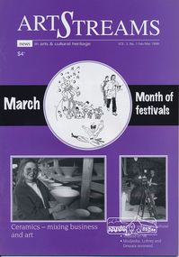
Journal, Peter Doughtery, ArtStreams: News in arts and cultural heritage; Vol. 3, No. 1, Feb-Mar 1998, 1998
Vol. 3, No. 1, Feb-Mar 1998 CONTENTS MUSICAL MURAL Billie Holliday, Louis Armstrong and Jelly Roll Morton appearing in Eltham 2 OBITUARY Pioneer painter and landscape gardener Peter Glass 5 SHORT STORY A place for heroes by David Gothard 7 MONTH OF FESTIVALS Souvenir guide to festivals of Banyule, Templestowe Village, Pettys Orchard Antique Apple and Warrandyte 9-24 A SENSE OF PLACE Exhibition of banners depicting a lifestyle 23 CLEM CHRISTESEN, WRITER & EDITOR Publication of poetry covering 30 years of life and work 25 THEATRE IN 198 Playbills for Eltham Little Theatre, Heidelberg Theatre Company and Sherbrooke Theatre Company 26 CERAMICS How ceramicists mix business and art 27 ART AWARD FORUM Do art awards meet current needs? 28 IN THE HEAT OF SUMMER Busy month of theatre in Melbourne 29 BOOK REVIEWS 30, 31 "Peter Dougherty has been involved in the local art scene for many years. As publisher and editor of the arts magazine Artstreams, his comments on the various branches of the arts are widely respected. His "The Arts" column in the Diamond Valley Leader presents a brief summary for a much wider cross section of the local community. Peter also operates his own gallery and the Artstreams Cafe at the St Andrews market. Peter has a wealth of knowledge about present day and historical aspects of local art and artists." - Eltham District Historical Society Newsletter No. 161, March 2005Colour front and back cover with feature articles and literary pieces with photographs and advertisements printed in black and white. 36 pages, 30 cm. Vol. 1, no. 1 (Nov. 1996) - Vol. 10, no. 5 (summer ed. 2005/06) art streams, volumes, jazz mural, vladimir bykovec, peter glass, john street, david gothard, banyule festival, arts on burgundy, ward sagar, montsalvat, were street cafe, rosanna fire station community house, bibby's bahnhof cafe, templestowe village festival, pool & spa care centre, la piazza restaurant bar & cafe, recherche bespoke framers, warrandyte festival, margaret roadknight, mezze restaurant warrandyte, food for all seasons, rivergum gallery warrandyre, potters cottage, pettys orchard antique apple festival, fleur de feliss, allwood neighbourhood house, llobex image wizards, victorian artists supplies, ray liversidge, dynamic vegies, jackie wilson, boroondara litfest, mia mia gallery, eltham banners, geoff mosley, clem christesen, nina christesen, julie reiter, nillumbik art award, carolynn pickett, bulleen art & garden centre, hugh tolhurst, andrew sant, lucinda mcknight, drusilla modjeska, amanda lohrey, robert dessaix, michele lonsdale, volumes, eltham little theatre, heidelberg theatre company, doncaster theatre company -
 Greensborough Historical Society
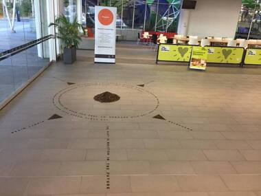
Photograph - Digital Image, Art at WaterMarc, July 2017, 22/07/2017
Photographs of an art installation by Jessie Stanley at WaterMarc Greensborough on 22/07/2017. From Jessie Stanley's FaceBook page :Dust to Dust is complete... It's an ephemeral site-specific work about how the Melbourne suburb of Greensborough has transformed over time. This area's exceptionally fertile soil [used by] by white settlers for farms, market gardens and orchards reshaped the Wurundjeri's traditional lands - and today the private sale and division of these farms informs the streetscape and town plan. With soil sourced locally this work reveals some of the area’s history - the text running around the perimeter was written by former resident Val Wilson, a snippet of her recollections of growing up in the area in the 1950s. The arrows and text act like a compass to orientate this site with greater Melbourne. On display in the lobby of Banyule Council until chance, time (or a broom) sweeps it away, Many thanks to Banyule City Council, Greensborough Historical Society and Valerie Wilson. "An artistic representation of Greensborough's history.Digital photographs of art installation.jessie stanley, watermarc, greensborough historical society, banyule council -
 Whitehorse Historical Society Inc.
Functional object - Butter Churn
Believed to have been owned originally by Alice and Arthur Fisher who had a 16 acre property in Mullum Mullum Road, Ringwood. The house was called Greenhill and was located at the highest point, now no. 28. They had a mixed farm including an orchard of fruit and nut trees, and a dairy cow. Alice milked the cow much to the amusement of her English family, who delighted in visiting. When the property was sold the butter churn went to Red Hill on the Mornington Peninsula. Arthur Lunt, donor has memories of its use in Red Hill, where his parents had a mixed farm. That property was sold c. 1950, and the butter Churn returned to the Ringwood Croydon area where it has remained unused for the last 65 years.|The butter churn has been in Croydon and Ringwood since 1952; it is typical of manually operated equipment in use on small properties 100 years ago.Cylindrical container, brown, mounted on board with handle underneath. To one side is a wooden handle and drive gears to spin cylinder. Cylinder has tight fitting lid and makers metal label on the side; opposite side has direction arrow embossed. Mounted on wooden base. Cream was put into churn, handle turned to spin drum until butter was produced. Five parts to the Churn.SVENSKA STOCKHOLM SWEDEN CENTRIFUGA,B.DAHLIA N0:0 SLATER PATENTdomestic items, food preparation -
 Harcourt Valley Heritage & Tourist Centre
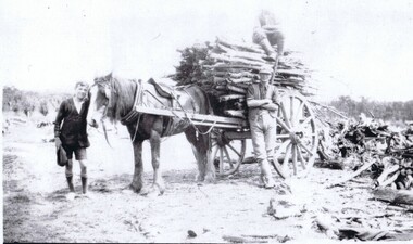
photograph, Cutting timber
Ken Peeler (at head of horse), Ken's father, Ern Peeler and brother Don Peeler (sitting on load) with dray-load of 'five-foot wood'. Peeler's Road, Barkers Creek. Photographed by Alice 'Girlie' Adams, approx. 1942. Families living at Barkers Creek and Woodbrook obtained contracts to supply 'five foot wood' to Thompson's Foundry and Castlemaine Woollen Co. Rows of wood, neatly stacked, 10’ high X 5’ wide covered many acres at each factory, ready for use in firing the boilers. Much bushland was thus cleared for orchard or pasture. The horse depicted is fully harnessed with bridle, eye-winkers and reins, dray collar, hames, shaft saddle with girth & pole straps and breeching straps. Neatly stowed under the dray shafts can be seen the props, used to keep the dray horizontal when the horse was to be taken out of the shafts. The dray was almost entirely constructed of wood, with steel tyres on the wheelsA reminder of the significance of local sources of fuel to some of Victoria’s biggest manufacturing concerns as well as depicting a major source of employment involving minimal capital. A B&W photograph depicting 2 men and a boy with a horse-drawn dray filled with wood. Photograph taken by Alice 'Girlie' Adams in 1942. Ken Peeler, Ern Peeler and Don Peeler appear in the picture along with a horse with no known name. -
 University of Melbourne, Burnley Campus Archives
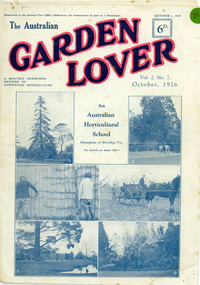
Newspaper - Newspaper Cutting, The Australian Garden Lover, The Burnley Gardens, October 1926
On cover pages are 6 photographs of Burnley College and the heading "An Australian Horticultural School Enterprise at Burnley,Vic". The 4 photos on the lower half of the cover page were used in "Green Grows Our Garden", by A.P Winzenreid, Hyland House (1991) p. 52. A.P Winzenreid described the photos as: Top left (photo 3): Espaliered fruit tree on fence, established and trained by George Russ and continued as a feature of interest into the 1950s. Located in old nursery area. Top right (photo 4): orchard spraying. Bottom left (photo 5): View of pavilion. Note Luffmann's pond and Pinus radiata planted in 1860s and removed by G. Manley and A. Tylee (1951-53). Bottom right (photo 6): A.W. Jessep (principal) and E.E. Pescott (lecturer) outside Principal's residence. (Photos 1 and 2 on the cover of the Garden Lover were not reproduced in "Green Grows Our Garden". The Australian Garden Lover, vol. 2 no. 7, October 1, 1926, p 266-7. Cover and two pages.the australian garden lover, green grows our garden, a.p. winzenreid, george russ, espaliered pear, old nursery, orchard, spraying, pavilion, ponds, pinus radiata, a. w. jessep, e. e. pescott, principal's residence, gardening publication, horticulture newspaper, 20s gardening -
 University of Melbourne, Burnley Campus Archives
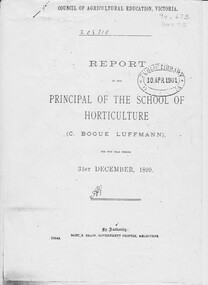
Document - Report, photocopy, Charles Bogue Luffman, Report by The Principal of School of Horticulture 1899, 1899
This is a photocopy of the original report. The report is headed "Council of Agricultural Education, Victoria". At this time the Burnley School of Horticulture was under the aegis of the Council of Agricultural Education. Photocopy of Annual Report by C. Bogue Luffmann, 2 copies Annual Report, an examination paper and essays on horticultural subjects by C. Bogue Luffmann and several students. It is 39 pages, contains an annual report, an examination paper and essays on horticultural subjects, by C Bogue Luffmann and also by several students. These essays include: The prospectus of commercial fruit growing in Victoria - C Bogue Luffmann - principal The economy of design in fruit trees - C Bogue Luffmann How to choose, prepare and maintain fertility in orchard and garden soil - Tessa Smith - 1st year student Villa Gardening - Marian W Thompson - 1st year student Lemon culture - Florence Jacomb - 1st year student - and MW Thompson An examination paper - FJ Wilmoth - 1st year student Appendix: Select list of 12 leading fruits suitable for local and export marketscharles bogue luffman, principal, students, horticulture, horticulture school report, villa gardening, lemon culture, fruit trees, horticulture writing 19th century, turn of the century, 1899 horticulture school, luffmann -
 Whitehorse Historical Society Inc.
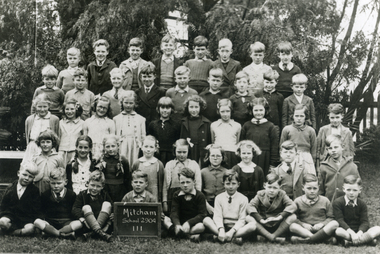
Photograph, Mitcham Primary School - Grade 3 - 1943, 1943
Black and white photograph of Students in grade 3 - Mitcham Primary School in 1943. Back Row - Robert Woolard; Neville McClean; Don Ireland; Ray Orchard; Maiford Green; Max Jones; Alan Treverton; Jim McBride. 2nd Row - Brian Bale; Gilbert Kerchevell; Graham Clements; Keith Jones; Vernon Osterlund; Andrew Stuart; Arthur Cutting; John Olson; Jack Treverton. 3rd Row - Maureen Webster; Valda Hancock; Keitha Petty; Thelma Burton; Barbara Savage; Esme Green; Barbara Woods; Irene Schafer; Peter Gorsuch. 4th Row - Margaret Bamford; Lorna Watt; Yvonne Robertson; Dorothy Summerton; Francis Ball; Patsy George; Hilton Boxshall; Alfred Gadsen.|Front Row - Andrew Bailey; Alan Baldwin; ??? Heaps; Peter Cumming; ?????; Leslie George; Les Fitzell; Ken Hennesy; Graham March.woolard, robert, mcclean, neville, ireland. don, orchard, ray, green, maiford, jones, max, mcbride, jim, treverton, alan, bale, brian, kerchevell, gilbert, clements, graham, keith, osterlund, vern, stuart, andrew, cutting, arthur, olson, john, jack, webster; maureen, hancock, valda, petty, keitha, burton, thelma, savage, barbara, esme, woods, schafer, irene, gorsuch, peter., margaret bamford;, watt, lorna, robertson, yvonne, summerton, dorothy, ball, francis, george, patsy, boxshall, hilton, gadsen, alfred, bailey, heaps, cumming, peter, leslie, fitzell, les, hennesy, ken, march, mitcham primary school no. 2904 -
 Eltham District Historical Society Inc
Photograph - Digital Photograph, Marguerite Marshall, Stuchbery Farm dairy, 14 March 2008
Stuchbery Farm was situated on the Plenty River bounded by Smugglers Gully to the north and La trobe Road, Yarrambat, to the east. Alan and Ada Stutchbery moved to the valley in 1890, first living in a tent where four children were born. Alfred built a home and outbuildings around 1896. They planted an orchard, then a market garden and developed a dairy. Published: Nillumbik Now and Then / Marguerite Marshall 2008; photographs Alan King with Marguerite Marshall.; p179 The dramatic steep-sided Plenty Gorge lies along the divide of two geological areas, and separates the Nillumbik Shire and the City of Whittlesea. On the Nillumbik side are undulating hills and sedimentary rock, and in Whittlesea, lies a basalt plain formed by volcanic action up to two million years ago. This provides the Plenty Gorge Park with diverse vegetation and habitats, making it one of Greater Melbourne’s most important refuges for threatened and significant species. The park, established in 1986, consists of around 1350 hectares, and extends 11 kilometres along the Plenty River, from Greensborough to Mernda. It provides a wildlife corridor for around 500 native plant and 280 animal species. The area’s plentiful food and water attracted the Wurundjeri Aboriginal people and then European settlers. By 1837 squatters had claimed large runs of land for their sheep and cattle. The Plenty Valley was among the first in the Port Phillip District to be settled - mainly in the less heavily timbered west - and was proclaimed a settled district in 1841. But by the late 1880s, the settlers’ extensive land clearing for animal grazing, then agriculture, depleted the Wurundjeri’s traditional food sources, which helped to drive them away. Many Wurundjeri artefacts remain (now government protected), and so far 57 sites have been identified in the park, including scarred trees, burial areas and stone artefacts. Pioneer life could be very hard because of isolation, flooding, bushfires and bushrangers. Following the Black Thursday bushfires of 1851, basalt was quarried to build more fire-resistant homes. Gold discoveries in the early 1850s swelled the population, particularly around Smugglers Gully; but food production made more of an impact. In the late 1850s wheat production supplanted grazing. In the 1860s the government made small holdings available to poorer settlers. These had the greatest effect on the district, particularly in Doreen and Yarrambat, where orchards were established from the 1880s to 1914. Links with a prominent early family are the remains of Stuchbery Farm, by the river’s edge bounded by Smugglers Gully to the north and La Trobe Road, Yarrambat, to the east. The Stuchberys moved to the valley in 1890, and the family still lives in the area. In 1890, Alfred and Ada first lived in a tent where four children were born, then Alfred built the house and outbuildings around 1896. They planted an orchard, then a market garden, and developed a dairy. The family belonged to the local Methodist and tennis communities. Their grandson Walter, opened the Flying Scotsman Model Railway Museum in Yarrambat, which his widow, Vi, continues to run. Wal was also the Yarrambat CFA Captain for 22 years until 1987. Walter sold 24 hectares in 1976 for development - now Vista Court - and in 1990, the remaining 22.6 hectares for the park. Remaining are an early stone dairy and remnants of a stone barn, a pig sty and a well. Until it was destroyed by fire in 2003, a slab hut stood on the Happy Hollow Farm site, at the southern end of the park. The hut is thought to have been built in the Depression around 1893. This was a rare and late example of a slab hut with a domestic orchard close to Melbourne. Emmet Watmough and his family first occupied the hut, followed by a succession of families, until the Bell family bought it around 1948. There they led a subsistence lifestyle for 50 years, despite encroaching Melbourne suburbia. The Yellow Gum Recreation Area includes the Blue Lake, coloured turquoise at certain times of the year. Following the 1957 bushfires, this area was quarried by Reid Quarries Pty Ltd for Melbourne’s first skyscrapers, then by Boral Australia. However in the early 1970s water began seeping into the quarry forming the Blue Lake and the quarry was closed. The State Government bought the site in 1997 and opened it as a park in 1999.This collection of almost 130 photos about places and people within the Shire of Nillumbik, an urban and rural municipality in Melbourne's north, contributes to an understanding of the history of the Shire. Published in 2008 immediately prior to the Black Saturday bushfires of February 7, 2009, it documents sites that were impacted, and in some cases destroyed by the fires. It includes photographs taken especially for the publication, creating a unique time capsule representing the Shire in the early 21st century. It remains the most recent comprehenesive publication devoted to the Shire's history connecting local residents to the past. nillumbik now and then (marshall-king) collection, ada stuchbery, alan stuchbery, dairy, stuchbery farm, farm buildings, yarrambat, plenty gorge park -
 Eltham District Historical Society Inc
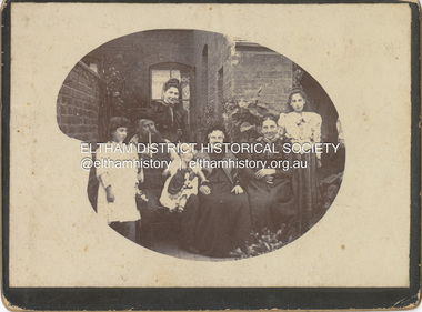
Photograph - Cabinet Photograph, William Ingram family, Birmingham, England, c.1880
William Ingram with possibly his wife Pamela Thomas and family members. William is second from left with pipe, the others unidentified. The family lived in Birmgham, England. William, a baker died in 1905. William and Pamela had six children; William George Grove (1861-1939), Elizabeth (1865), Evan Thomas (1867-1956), Joseph (1868-1934), Louis (1870-1941) and John (1872-1958). John Ingram learnt his trade from his father but following a quarrel with his father, he ran away and worked his passage to Australia as a ships baker. His elder brother Evan was already in Australia living in Malvern. It was here that he met Ada Key. John and Ada were married in Fremantle, Western Australia. They travelled to England then Cape Town, a family already started. They returned to Melbourne and in 1901 bought land at Research where he worked to establish an orchard and worked at night asa baker in Eltham. The fashion and hairstyles appear trypical of around 1880ingram family, birmingham, william ingram, baker, pam thoonen (nee ingram) collection -
 Eltham District Historical Society Inc
Negative - Photograph, Eltham, Vic, c.1890
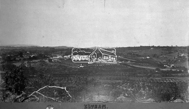
View looking northeast from present day Ely Street (near intersection of present day Cronus Court and Porter Street) across what will become the site of Eltham High School towards Main Road showing the Eltham Courthouse and Police station. View is very similar to the sketch of Eltham published in 'The Illustrated Australasian News', December 26, 1884, p212. Note the large bluestone cell block behind police house and stable. George Knapman's Shoeing Forge next to the courthouse and the concentration of buildings around the Evelyn Hotel and Watson's Eltham Hotel on opposite sides of Main Road at Pitt street. Also note George Stebbing's cottage (c.1860) on Pitt Street behind the courthouse and 'Sunnyside' (home of W.J. Taylor built c.1885) at the top of the hill on Bible Street. In the foreground are orchards running up to the main street, Maria Street and also between Brougham Street and Dalton Street bordered by Bible Street.This photo forms part of a collection of photographs gathered by the Shire of Eltham for their centenary project book,"Pioneers and Painters: 100 years of the Shire of Eltham" by Alan Marshall (1971). The collection of over 500 images is held in partnership between Eltham District Historical Society and Yarra Plenty Regional Library (Eltham Library) and is now formally known as the 'The Shire of Eltham Pioneers Photograph Collection.' It is significant in being the first community sourced collection representing the places and people of the Shire's first one hundred years.Digital image 4 x 5 inch B&W Negshire of eltham pioneers photograph collection, eltham, 1890, bible street, brougham steet, dalton street, eltham courthouse, eltham hotel, evelyn hotel, franklin street, grant house, knapmans forge, main road, maria street, orchards, police residence, police station, pre 1900, stebbing cottage, sunnyside, w.b. andrew corn store, watsons hotel, little eltham -
 Eltham District Historical Society Inc
Document - Folder, Partington family
Charles Partington married Ellen Whatmough; they and their children, Robert and James, came to Australia in 1857 because Ellen's brother, Robert Whatmough, had come here in 1841. Whatmough was Melbourne's first lamplighter while also working in John Batman's Spencer Street orchard; he moved in 1842 to establish an orchard in Greensborough. Both Partington boys died soon after the family arrived at Greensborough but later two daughters were born, Prudina and Maria, and five sons, including William . On arrival Charles Partington began work for Mr Flintoff at Black Hills and was later toll keeper on what is now Watsonia Road. He was later a successful orchardist. William Partington married Annie-May Medhurst, daughter of David Medhurst and Martha Ruston, daughter of Peter Ruston who had settled in Greensborough in the 1850s after working for Mr Hooper in Darebin Creek, then moved to Panton Hill in 1866 working as a carrier. The Rustons had six children, including Martha and James. Martha married David Medhurst in 1882 who was the son of David Medhurst and Charity Jane Pink. After David's death, Charity Jane married George Wescott. David and Martha Medhurst had eight children, including Annie May. They bought land in Main Street, Greensborough and set up as a greengrocer. William and Annie-May Partington's family home, Willis Vale, purchased from Mr Meagher by William's father, Charles; it was built by Meagher in 1839 but destroyed by vandals in 1966 after being compulsory purchased for parkland now called Partington's Flat. Their children were Eva, Grace, Alan, Jessie, and Jack. They attended Greensborough Primary School. Alan married Wyn. Contents Newspaper article: "Link with the past", Diamond Valley News, 21 February 1984. Alan Partington's research on Robert Whatmough, early settler in Greensborough, and his brother-in-law Charles Partington. Newspaper article: "How early families linked up", Diamond Valley News, 28 February 1984. Alan Partington's research into the Ruston and Medhurst families. Newspaper article: "Old days recalled", Diamond Valley News, 13 March 1984. Alan Partington's research in the Partington family.Newspaper clippings, A4 photocopies, etcalan partington, robert whatmough, watmough park greensborough, robert partington, james partington, elen partington nee whatmough, road tolls watsonia road, prudina partington, maria partington, william partington, willis vale, partington's flat greensborugh, mr meagher of greensborough, apollo parkways estate, charles partington, annie-may partington nee medhurst, david medhurst, martha medhurst (nee ruston), jack medhurst, peter ruston, hooper of darebin creek, greensborough hotel, james ruston, charity jane medhurst (nee pink), main street greensborough, eva partington, grace partington, jessie partington, jack partington, orchards in plenty river area, greensborough primary school, wyn partington, flintoff of black hills -
 Mt Dandenong & District Historical Society Inc.
Photograph, The Valley of the Harmony Vale Settlement c1910, 1973
Scene looking across the valley of Harmony Vale from Barbers Road. c1910. Photograph copied by John Lundy-Clarke in 1973. This photograph has a detailed inscription on the back handwritten by John Lundy-Clarke in 1974.The valley of the Harmony Vale settlement on the Olinda Creek from Barbers Road. "Shiloah" on far left centre. John William Richardson's home among trees left of centre. Homestead Harmony Vale above log yard (see below) and among orchard trees. Child Bros sawmill and log yard with logs among trees above flat cultivation right of centre. Bert Childs home beyond "Harmony Vale". Lucas' "Glenrivers" is in gully above main clearing centre top left. Frank Childs home among trees centre of picture. Taken about 1910 by Rose Series. Copied 1974 JLC.kalorama, harmony vale, olinda creek, barbers road, shiloah, sawmill, child, bert child, glenrivers -
Whitehorse Historical Society Inc.
Letter - Correspondence, The Fruitgrowers and Primary Producers Defence League of Australia, 1946
To WG Payne from Reporter Pty Ltd1 4.1946To WG Payne from Reporter Pty Ltd account rendered 2 6.1946Ditto 3 4.1946To WG Payne from G Compton re inconvenience to growers in stands ôKö & ôLö 4 6.1946To WG Payne from HJ Noonan re registration of citrus growers & limit planting 5n.some activities of District Council since last year 6 4.1946To WG Payne from JM Ward re Mr GayfordÆs lecture on pest control measures 7 7.1946To WG Payne from HJ Noonan re notice of AGM 8 4.1946To WG Payne from G Handsyde re meeting concerning citrus growers organizations 9 5.1946To WG Payne from GW Gayford re a suitable date for his lecture 10 6.1946To WG Payne from G Handsyde re an official representation at meeting 11 5.1946To WG Payne from G Handsyde re lecture by Mr Gayford 12 3.1946To WG Payne from G Compton re congestion in sheds ôKö & ôLö 13 3.1946To WG Payne from W McKenzie re registration & licensing of growers 1410.1945To WG Payne from GW Gayford re DDT spray substitute for nicotine-sulphate 1510.1945To RS Ryan from FM Forde re concern of importation of apples from America 16n.d.To M&MDC;DL from W Payne re action of Inspectors condemning bushel cases 1710.1945To WG Payne from JM Ward re neglected orchards due to shortage of labour 1810.1945To MMDC F&PP Defence League from HC Pope re production of Secateurs 1910.1945To WG Payne from JM Ward re transferring of Orchard Supervisors 20 2.1945T0 WG Payne from HJ Noonan re copy of Conference report. To WG Payne from Reporter Pty Ltd clubs and associations, fruitgrowers and primary producers defence league of australia -
 Eltham District Historical Society Inc
Photograph, Liz Pidgeon, Heritage Excursion; East of Eltham, 6 Sep 2014, 20 May 2017
Newsletter No. 218, September 2014 September Excursion - East of Eltham Walk In Newsletter No. 197, March 2011, there was a brief history of Crown Allotment 15 Section 5 Parish of Nillumbik (CA 15) a parcel of land of a quarter of a square mile extending from Eucalyptus Road to Reynolds Road at the eastern extremity of Eltham. From the 1940s it was known as Stokes orchard. In later years it has been subdivided for residential purposes but leaving significant areas as power line and water supply reserves and bushland reserves that are habitat for the threatened For our excursion on 6th September we intend to walk through CA 15 to a bushland reserve east of Reynolds Road. The walk will traverse the boundary between suburban Eltham and the non-urban areas to the south and east. This is a pleasant walk through residential areas and bushland. Along the way we will discuss the early and more recent history of CA 15 as well as local natural history and geology. This walk is about 3.5 km in length and will take 2 to 2.5 hours. It will start at 2pm at the corner of Eucalyptus Road, Pitt Street and Nyora Road.Born Digitaleltham east, eltham district historical society, heritage excursion, activities, nyora road, reynolds road, gum tree road reserve, diosma road, stokes orchard, eucalyptus road -
 Eltham District Historical Society Inc
Photograph, Liz Pidgeon, Heritage Excursion; East of Eltham, 6 Sep 2014, 20 May 2017
Newsletter No. 218, September 2014 September Excursion - East of Eltham Walk In Newsletter No. 197, March 2011, there was a brief history of Crown Allotment 15 Section 5 Parish of Nillumbik (CA 15) a parcel of land of a quarter of a square mile extending from Eucalyptus Road to Reynolds Road at the eastern extremity of Eltham. From the 1940s it was known as Stokes orchard. In later years it has been subdivided for residential purposes but leaving significant areas as power line and water supply reserves and bushland reserves that are habitat for the threatened For our excursion on 6th September we intend to walk through CA 15 to a bushland reserve east of Reynolds Road. The walk will traverse the boundary between suburban Eltham and the non-urban areas to the south and east. This is a pleasant walk through residential areas and bushland. Along the way we will discuss the early and more recent history of CA 15 as well as local natural history and geology. This walk is about 3.5 km in length and will take 2 to 2.5 hours. It will start at 2pm at the corner of Eucalyptus Road, Pitt Street and Nyora Road.Born Digitaleltham east, eltham district historical society, heritage excursion, activities, nyora road, reynolds road, gum tree road reserve, diosma road, stokes orchard, eucalyptus road