Showing 28634 items matching "street street"
-
 Ballarat Heritage Services
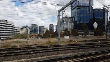
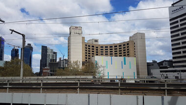
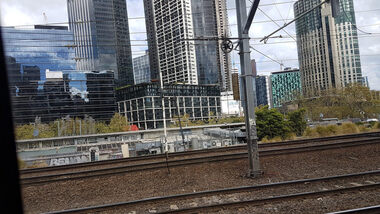
Digital photograph, Lisa Gervasoni, train between Flinders and Spencer Street, 2017
... train between Flinders and Spencer Street...flinders street... Office goldfields melbourne train flinders street spencer street ...melbourne, train, flinders street, spencer street, northbank, buildings, cbd -
 Ballarat Heritage Services
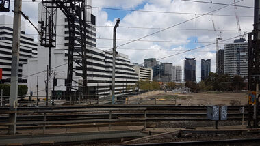
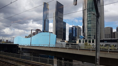
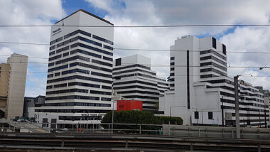
Photograph - Digital photograph, Lisa Gervasoni, Train between Flinders and Spencer Street, 2017
... Train between Flinders and Spencer Street...flinders street...Photograph of a train between Flinders and Spencer Street... Office goldfields melbourne train flinders street spencer street ...Photograph of a train between Flinders and Spencer Street Melbournemelbourne, train, flinders street, spencer street, northbank, buildings, cbd -
 Ballarat Heritage Services
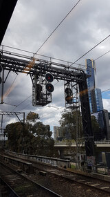
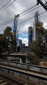
Photograph - Digital photograph, Lisa Gervasoni, Train between Flinders and Spencer Street Stations, 2017
... Train between Flinders and Spencer Street Stations...flinders street... Office goldfields melbourne train flinders street spencer street ...Colour photograph of railway power lines and signals. melbourne, train, flinders street, spencer street, northbank, buildings, cbd, tranmission lines, power lines, railway -
 Ballarat Heritage Services
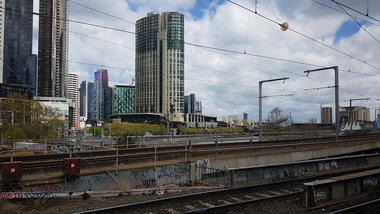
Digital photograph, Lisa Gervasoni, Train between Flinders and Spencer Street, 2017
... Train between Flinders and Spencer Street...flinders street... Office goldfields melbourne train flinders street spencer street ...Photograph of a Melbourne train on the Lilydale line. melbourne, train, flinders street, spencer street, northbank, buildings, cbd, lilydale train -
 Ballarat Heritage Services
Digital photograph, Lisa Gervasoni, train between Flinders and Spencer Street, 2017
... train between Flinders and Spencer Street...flinders street... Office goldfields melbourne train flinders street spencer street ...melbourne, train, flinders street, spencer street, northbank, buildings, cbd -
 Ballarat Heritage Services
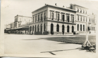
Photograph - Photograph - Black and White, Ballarat Celebrations 1937, 1937
... sturt street...Bank on the north west corner of Sturt and Lydiard Streets... and Lydiard Streets. I suspect that these are photographs before ...Bank on the north west corner of Sturt and Lydiard Streets. I suspect that these are photographs before the celebrations for the coronation. See The Argus 13 May 1937 "Celebrations in Many Country Towns" Ballarat Celebrations BALLARAT Wednesday - Special Coronation celebrations were largely attended In the morning there was a service In Christ Church, at which representatlves of the council and other public bodies were present There was a similar gathering in St Andrew's Kirk At a civic service in the Alfred Hall in the afternoon the address was given by the Bishop of Ballarat (the Right Rev W Johnson). Bishop Johnson spoke of the personal association of King George V with his people, and said that the present King and Queen would be equally concerned with the welfare of their subjects The Revs H A Horsfall and B E Williams co-operated In the service, which was presided over by the Mayor (Councillor J Pryor) Mr Lloyd Lindsay recited Mase?Coronation ode and Miss W Ritchie sang "Land of Hope and Glory ' At night a Coronation concert was held in the Alfred HallSmall black and white photographB 249 on versomax walters, ballarat, 1937, celebrations, bank, sturt street, lydiard street, anniversary -
 Ballarat and District Irish Association
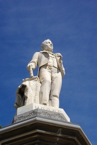
Photograph - Colour, Clare Gervasoni, Thomas Moore Statue, Sturt Street Ballarat, 2011, 29/12/2014
... Thomas Moore Statue, Sturt Street Ballarat, 2011...sturt street... Street Ballarat.... statue sturt street surt street gardens A coloured photograph ...Thomas Moore (28 May 1779 – 25 February 1852) was an Irish poet, singer, songwriter, and entertainer, now best remembered for the lyrics of "The Minstrel Boy" and "The Last Rose of Summer". (Wikipedia, accessed 05 April 2014)A coloured photograph of the Thomas Moore Statue in Sturt Street Ballarat.ballarat, moore, thomas moore, poet, statue, sturt street, surt street gardens -
 Ballarat Tramway Museum
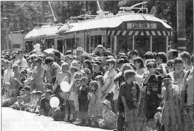
Newspaper, The Courier Ballarat, "New brochure welcomes lake visitors", 12/03/1996 12:00:00 AM
... Street Parade... day) in Wendouree Parade. Also has a story about the Street... Festival Street Parade Street Organ Newspaper cutting from ...Newspaper cutting from The Courier, Ballarat, Tuesday 12/3/1996 of photos of the Begonia Festival Parade on 11/3 (previous day) in Wendouree Parade. Also has a story about the Street Organ of Damon O'Donoghue. Included in the five photos are one of the street organ and one of the crowd lined up in Wendouree Parade with tram 38 and 661 in the background.trams, tramways, begonia festival, street parade, street organ -
 Buninyong & District Historical Society
Photograph - Original Colour Photo, Streetscape of Learmonth St & Warrenheip St corner, Buninyong, taken from southwest, showing Crown Hotel and corner store, 1982
... Learmonth Street..., Buninyong Town Hall Learmonth Street Buninyong goldfields The photo ...The photo shows the streetscape of the corner of Learmonth and Warrenheip Sts, Buninyong, taking in the Crown Hotel and corner store (before redecoration).The photo shows former decoration of the Crown Hotel and corner store. From where the photo was taken, it also shows the avenue of elm trees before the service road was built on this western part of Learmonth St.Streetscape of Learmonth St & Warrenheip St corner, Buninyong, taken from southwest, showing Crown Hotel and corner store."1982"buninyong, crown hotel, corner shop, learmonth street, warrenheip street, streetscape -
 Kew Historical Society Inc
Map - Subdivision Plan, Grenville Estate, 1922
... glenferrie road, alfred street, thomas street, cotham road... in Cotham Road and Alfred Street, Kew, the auctioneers emphasised... plans - kew grenville estate glenferrie road, alfred street ...Pru Sanderson, in her groundbreaking ‘City of Kew Urban Conservation Study : Volume 2 - Development History’ (1988), summarised the periods of urban development and subdivisions of land in Kew. The periods that she identified included 1845-1880, 1880-1893, 1893-1921, 1921-1933, 1933-1943, and Post-War Development. These periods were selected as they represented periods of rapid growth or decline in urban development. An obvious starting point for Sanderson’s groupings involved population growth and the associated economic cycles. These cycles also highlighted urban expansion onto land that was predominantly rural, although in other cases it represented the decline and breakup of large estates. A number of the plans in the Kew Historical Society’s collection can also be found in other collections, such as those of the State Library of Victoria and the Boroondara Library Service. A number are however unique to the collection.Subdivision plans are historically important documents used as evidence of the growth of suburbs in Australia. They frequently provide information about when the land was sold on which a built structure was subsequently constructed as well as evidence relating to surveyors and real estate and financial agents. The numerous subdivision plans in the Kew Historical Society's collection represent working documents, ranging from the initial sketches made in planning a subdivision to printed plans on which auctioneers or agents listed the prices for which individual lots were sold. In a number of cases, the reverse of a subdivision plan in the collection includes a photograph of a house that was also for sale by the agent. These photographs provide significant heritage information relating house design and decoration, fencing and household gardens.In advertising the twenty-two sites of the Grenville Estate in Cotham Road and Alfred Street, Kew, the auctioneers emphasised the proximity of the development to shops, schools, and churches. That mansions surrounded the Estate was publicised as an added attraction. The plan shows how at this stage A regrettable aspect of this plan is that it is pasted over, and obscures a real estate photograph by the Kew photographer Josiah Earl Barnes.subdivision plans - kew, grenville estate, glenferrie road, alfred street, thomas street, cotham road -
 Kew Historical Society Inc
Plan - Subdivision Plan, Forres Estate, East Kew, 1919, 1919
... argyle road, simpson street, hubert street, normanby road... of High Street, Kew. The name of the estate was derived from... plans - kew forres estate argyle road, simpson street, hubert ...Pru Sanderson, in her groundbreaking ‘City of Kew Urban Conservation Study : Volume 2 - Development History’ (1988), summarised the periods of urban development and subdivisions of land in Kew. The periods that she identified included 1845-1880, 1880-1893, 1893-1921, 1921-1933, 1933-1943, and Post-War Development. These periods were selected as they represented periods of rapid growth or decline in urban development. An obvious starting point for Sanderson’s groupings involved population growth and the associated economic cycles. These cycles also highlighted urban expansion onto land that was predominantly rural, although in other cases it represented the decline and breakup of large estates. A number of the plans in the Kew Historical Society’s collection can also be found in other collections, such as those of the State Library of Victoria and the Boroondara Library Service. A number are however unique to the collection.Subdivision plans are historically important documents used as evidence of the growth of suburbs in Australia. They frequently provide information about when the land was sold on which a built structure was subsequently constructed as well as evidence relating to surveyors and real estate and financial agents. The numerous subdivision plans in the Kew Historical Society's collection represent working documents, ranging from the initial sketches made in planning a subdivision to printed plans on which auctioneers or agents listed the prices for which individual lots were sold. In a number of cases, the reverse of a subdivision plan in the collection includes a photograph of a house that was also for sale by the agent. These photographs provide significant heritage information relating house design and decoration, fencing and household gardens.An annotated subdivision plan for the Forres Estate, Kew East. The estate was advertised in 1919, the Melbourne Auctioneers being represented locally by Henry Kellett, Estate Agent of High Street, Kew. The name of the estate was derived from the mansion (demolished 2016) of the same name in Normanby Road, which was at one stage owned by the Mayor of Kew, Cr. J. S. Were.subdivision plans - kew, forres estate, argyle road, simpson street, hubert street, normanby road -
 Kew Historical Society Inc
Plan - Subdivision Plan, Jas R Mathers Son & McMillan, Macartney Estate, East Kew, c. 1925
... Macartney Street... for sale on either side of Macartney Street (now Macartney Avenue... plans - east kew macartney estate Macartney Street Mount Street ...Pru Sanderson, in her groundbreaking ‘City of Kew Urban Conservation Study : Volume 2 - Development History’ (1988), summarised the periods of urban development and subdivisions of land in Kew. The periods that she identified included 1845-1880, 1880-1893, 1893-1921, 1921-1933, 1933-1943, and Post-War Development. These periods were selected as they represented periods of rapid growth or decline in urban development. An obvious starting point for Sanderson’s groupings involved population growth and the associated economic cycles. These cycles also highlighted urban expansion onto land that was predominantly rural, although in other cases it represented the decline and breakup of large estates. A number of the plans in the Kew Historical Society’s collection can also be found in other collections, such as those of the State Library of Victoria and the Boroondara Library Service. A number are however unique to the collection.Subdivision plans are historically important documents used as evidence of the growth of suburbs in Australia. They frequently provide information about when the land was sold on which a built structure was subsequently constructed as well as evidence relating to surveyors and real estate and financial agents. The numerous subdivision plans in the Kew Historical Society's collection represent working documents, ranging from the initial sketches made in planning a subdivision to printed plans on which auctioneers or agents listed the prices for which individual lots were sold. In a number of cases, the reverse of a subdivision plan in the collection includes a photograph of a house that was also for sale by the agent. These photographs provide significant heritage information relating house design and decoration, fencing and household gardens.The Macartney Estate subdivision advertised 21 lots for sale on either side of Macartney Street (now Macartney Avenue) and Evans Road in what was then designated as East Kew. Most of the houses shown on the south side of Macartney Street then, as now, have rear entrances on Mount Street, however a number of these blocks have since been further subdivided to allow for the building of new houses on the rear of a block. Brougham Place is marked on the plan but is now called Daniell Place."C"subdivision plans - east kew, macartney estate, macartney street, mount street, evans road, brougham place -
 Kew Historical Society Inc
Plan - Subdivision Plan, J R Mathers & McMillan, Glenarbor Estate, 1934
... Wellington Street... bordering Wellington and Denmark Streets and Fenton Avenue... Wellington Street Denmark Street "D" The little-known Glenarbor ...Pru Sanderson, in her groundbreaking ‘City of Kew Urban Conservation Study : Volume 2 - Development History’ (1988), summarised the periods of urban development and subdivisions of land in Kew. The periods that she identified included 1845-1880, 1880-1893, 1893-1921, 1921-1933, 1933-1943, and Post-War Development. These periods were selected as they represented periods of rapid growth or decline in urban development. An obvious starting point for Sanderson’s groupings involved population growth and the associated economic cycles. These cycles also highlighted urban expansion onto land that was predominantly rural, although in other cases it represented the decline and breakup of large estates. A number of the plans in the Kew Historical Society’s collection can also be found in other collections, such as those of the State Library of Victoria and the Boroondara Library Service. A number are however unique to the collection.The Kew Historical Society collection includes almost 100 subdivision plans pertaining to suburbs of the City of Melbourne. Most of these are of Kew, Kew East or Studley Park, although a smaller number are plans of Camberwell, Deepdene, Balwyn and Hawthorn. It is believed that the majority of the plans were gifted to the Society by persons connected with the real estate firm - J. R. Mathers and McMillan, 136 Cotham Road, Kew. The Plans in the collection are rarely in pristine form, being working plans on which the agent would write notes and record lots sold and the prices of these. The subdivision plans are historically significant examples of the growth of urban Melbourne from the beginning of the 20th Century up until the 1980s. A number of the plans are double-sided and often include a photograph on the reverse. A number of the latter are by noted photographers such as J.E. Barnes.The little-known Glenarbor Estate comprised 23 allotments bordering Wellington and Denmark Streets and Fenton Avenue. The auction of the allotments in the Estate was held in the Kew Recreation Hall. The purported advantages to Kew are identified on the plan, such as the close proximity of the entrance to the Kew Railway Station and access to shops in Denmark Street. Due to its location, the subdivision was pitched at commercial as well as residential purchasers. The Estate was to cause a crisis in the Kew Council as a majority of councillors voted on 29 May to acquire the entire Estate as the location of a new Town Hall. The Estate was said to be valued at £50,000. A later meeting was to rescind the vote, instead opting for the compulsory acquisition of South Esk on the corner of Charles Street and Cotham Road. That acquisition was to be overturned by the State Government. The debate about the purchase of the Glenarbor Estate by Council coincided with the decision to widen High Street on the South side between Cotham Road and the Junction."D"subdivision plans - kew, glenarbor estate, wellington street, denmark street -
 Kew Historical Society Inc
Photograph, Flinders Street, from the corner of Swanston Street, 1874
... Flinders Street, from the corner of Swanston Street...flinders street...Flinders Street, from the corner of Swanston Street, 1874... melbourne flinders street swanston street Flinders Street, from ...Flinders Street, from the corner of Swanston Street, 1874. Photographic reproduction, source unknown.melbourne, flinders street, swanston street -
 Sunbury Family History and Heritage Society Inc.
Photograph, Former medical centre, 2001
... Horne Street... and was on the corner of Horne and Neill Streets. Before it was demolished... with a corrugated iron roof with its street number clearly attached... Global Learning Centre Macedon Street Sunbury melbourne The house ...The house was one of Sunbury's older houses and was on the corner of Horne and Neill Streets. Before it was demolished for larger commercial development, the property was a medical centre and later an employment and training office. A coloured photograph of a weatherboard house with a corrugated iron roof with its street number clearly attached to the front of the house.horne street, neill street -
 Sunbury Family History and Heritage Society Inc.
Photograph, Royal Hotel, Pre 1936
... Brook Street... -east corner of Evans and Brook Streets in Sunbury. The original... and three men standing beside it in the street. There are two other... Global Learning Centre Macedon Street Sunbury melbourne The hotel ...The hotel in the photograph is the original single storey Royal Hotel with its corner entrance. It stood on the south -east corner of Evans and Brook Streets in Sunbury. The original building was damaged by fire in 1936 and a two storey red brick building replaced it on the original site with the hotel entrance facing onto Brook Street. The hotel is in close proximity to the railway station so it was able to offer accommodation to travellers visiting the Asylum.The Royal Hotel is one of two surviving hotels built in Evans Street. Originally there were four hotels built between Station and Brook Streets along Evans Street.A non-digital black and white photograph of a white single story hotel building showing the original corner entrance and three men standing beside it in the street. There are two other entrances on each side and three windows down one side. The iron clad roof has three chimneys.royal hotel, sunbury, hotels, brook street, evans street -
 Sunbury Family History and Heritage Society Inc.
Photograph, Ball Court Hotel
... Macedon Street... corner of Macedon and Jackson Streets. The hotel was called... Global Learning Centre Macedon Street Sunbury melbourne The hotel ...The hotel was built some time shortly after 1842 by John Cahill, who arrived in the colony in 1842 from Thurles in Tipperary, Ireland. The building although much altered with render covering the original \blue stone structure is on the south-west corner of Macedon and Jackson Streets. The hotel was called the Ball Court because Cahill also had a hand-ball court set up behind the hotel.Originally five hotels were built along Macedon Street between Jackson Creek and Evans Street. The Ball Court Hotel is the only one still standing and operating as a hotel.A non-digital black and white photograph with a cream border of man and three ladies standing outside a single story blue stone hotel building with a corner entrance. AS well as the corner entrance there is another doorway on the RHS along with three narrow windows and three other windows on the other side. One of the ladies is holding a little child. Two trees surrounded by tree guards are on each side of the photograph.Ball Court Hotel, John Cahillball court hotel, hotels, sunbury, macedon street, jackson street, ball court -
 Sunbury Family History and Heritage Society Inc.
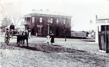
Photograph, Rupertswood Hotel
... Evans Street... and Evans Streets in Sunbury. The two storey bluestone building...A non-digital black and white photograph of a street... Global Learning Centre Macedon Street Sunbury melbourne ...The photograph was taken at the intersection of Brook and Evans Streets in Sunbury. The two storey bluestone building was the Rupertswood Hotel, which was on the NE corner of the intersection and the single storey Royal Hotel building in the foreground was on the opposite corner. The Millett family originally owned both hotels. The Rupertswood Hotel was demolished in December 1974 to make way for a modern retail store. In 1939 the old Royal Hotel building was damaged by fire and replaced with a two storey red brick building.The Rupertswood and Royal Hotels were two of the earliest hotels to be erected in the Sunbury township.A non-digital black and white photograph of a street photograph featuring an intersection with a two storey bluestone building on one corner and a partial view of a single storey rendered building on the opposite corner. Two children are standing on the side of the road and a man is in a horse-drawn jinker. george millett, royal hotel, rupertswood hotel, evans street, brook street, hotels -
 Sunbury Family History and Heritage Society Inc.
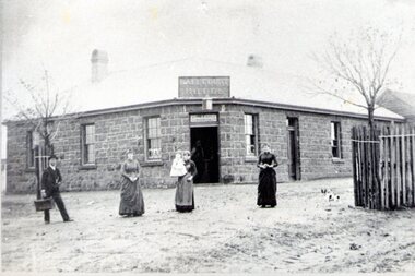
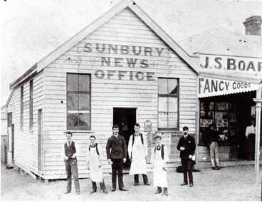
Photograph, Sunbury News Office
... Brook Street... family initially in Brook Street closer to the station. In 1880... Global Learning Centre Macedon Street Sunbury melbourne ...The Sunbury News Office was established by the Boardman family initially in Brook Street closer to the station. In 1880 Arthur Boardman opened a bookshop and news agency and in 1882, he printed the first issue of the Sunbury News.The building was on the SW corner of Brook and O'Shanassy Streets. Members of the Boardman family also ran the adjacent business. The Sunbury News was the local paper for residents until the late 1960s A non-digital black and white photograph with a cream border of a weatherboard news office building with six men standing the front. Three of the men are wearing white aprons. An attached building with a verandah is on the RHS of the office building.sunbury news, arthur boardman, brook street, o'shanassy street -
 Sunbury Family History and Heritage Society Inc.
Photograph, Royal Hotel
... Evans Street... Streets. For many years the MIllett family owned and ran the hotel... Global Learning Centre Macedon Street Sunbury melbourne The two ...The two storey building in the photograph is the Royal Hotel. The original single storey hotel was damaged by fire in the 1930s so the double storey red brick building replaced it on the same site, which is at the intersection of Evans and Brook Streets. For many years the MIllett family owned and ran the hotelThe Royal Hotel is one of four hotels that operated in Evans Street between Station and Brook Streets. Only two of those hotels are operating on their original sites. The other two have been demolished and replaced with retail businesses.An enlarged black and white non-digital photograph with a narrow cream border of a streetscape of an intersection with a two storey brick building on one corner and cars park by the kerb outside the building.royal hotel, millett family, evans street, brook street, hotels -
 Sunbury Family History and Heritage Society Inc.
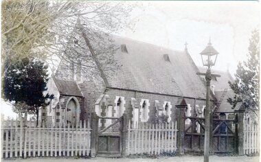
Photograph, St. Mary's Anglican Church, Pre1910
... O'Shanassy Street... of land on the corner of Stawell and O'Shanassy Streets... Global Learning Centre Macedon Street Sunbury melbourne ...This is an early photograph of St. Mary's Anglican Church in Sunbury. On 13th October 1863, the Government granted one acre of land on the corner of Stawell and O'Shanassy Streets for the building of a church. he first service was held on 24th November 1867. After that date subsequent additions were made. The gas lamp outside the church indicates that the photograph was taken before electric power was installed in Sunbury. St. Mary's Anglican Church is one of the earliest places of worship to be built in Sunbury.A non-digital sepia post card photograph of a small bluestone church with a slate roof with a wooden picket fence and two gates across the front. A gas lamp is on the pathway. Peter Collett's signature is on the back as well as a sticker with number 7 written on itst. mary's church of england., o'shanassy street, stawell street -
 Sunbury Family History and Heritage Society Inc.
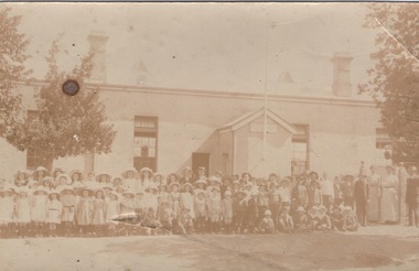
Photograph, Sunbury State School
... Stawell Street... No.1002 was built on the corner of Macedon and Stawell Streets... Global Learning Centre Macedon Street Sunbury melbourne The first ...The first building which housed Sunbury State School No.1002 was built on the corner of Macedon and Stawell Streets in the early 1870s and functioned as the local State School until 1912 when a sturdier red brick structure replaced on the same site. In 1999 Sunbury State School was relocated in the former Industrial School heritage buildings in Jacksons Hill. The existing building in Macedon Street was incorporated into the Sunbury Community Health Centre. The school in the photograph is the original Sunbury State School NO. 1002 building, where many early Sunbury residents attended. A non-digital black and white photograph in post card format of a crowd of children outside a school building. Four teachers are standing on the RHS of the image.sunbury state school no. 1002, stawell street, macedon street, schools -
 Sunbury Family History and Heritage Society Inc.
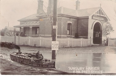
Photograph, Sunbury Post Office
... Brook Street.... It opened on the corner of Brook and Evans Streets in 1892. Prior... Global Learning Centre Macedon Street Sunbury melbourne ...The Sunbury Post Office with a residence pictured in the image was the first official post office building in the town. It opened on the corner of Brook and Evans Streets in 1892. Prior to that time postal services were conducted in an office at Sunbury Railway Station. Although the present day post office is still on the Brook-Evans Streets corner, the building has undergone many changes in services and appearances over the years. Like many country towns, the post office offered many services to the residents over the years. short message has been written on the back to a person in Stirling WA.sunbury post office, sunbury railway station, brook street, evans street, post offices -
 Sunbury Family History and Heritage Society Inc.
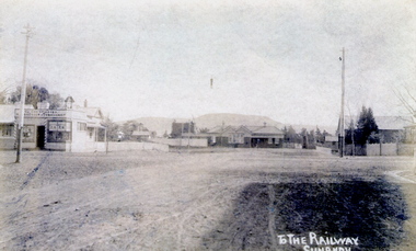
Photograph
... brook street... and Evans Street looking west and towards Sunbury Station. Mount... Global Learning Centre Macedon Street Sunbury melbourne The post ...The post card is an early view of the intersection of Brook and Evans Street looking west and towards Sunbury Station. Mount Holden is in the distance. Chris Christianson's shop is on the LHS of the picture with the post office on the RHS. This image is an early view of Sunbury town centre with the railway station and post office. Like many country towns of this era, The roads have been formed but not surfaced. A sepia photograph in post card format of a view of a town centre showing an intersection and some small buildings with a hill in the distance.TO THE RAILWAY/SUNBURYbrook street, evans street, sunbury railway station, christianson, chris. -
 Surrey Hills Historical Society Collection
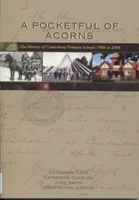
Book, A Pocketful of Acorns - This History of Canterbury Primary School : 1908-2008, c 2008
... molesworth street... canterbury road molesworth street highfield road leeds street ...Purchased in memory of Sue Slonek, Secretary of Surrey Hills Historical Society, volunteer with the Surrey Hills Neighborhood Centre Heritage Collection (Surrey Hills historical Society Collection). A history of Canterbury Primary School written to celebrate the school's 100 year anniversary - 1908-2008A history of Canterbury Primary School written to celebrate the school's 100 year anniversary - 1908-2008canterbury primary school, primary schools, (ms) judy stewart, (mr) ian phillips, (miss) gabriela aloisio, (mrs) marjorie pitt, (miss) joan eltham, (mr) - shannon, (mr) - besant, (mrs) anne bialecki, (ms) diane western, (ms) margaret mason, (miss) hilary barr, (mrs) hilary praetz, (ms) vicki eddison, (miss) margaret kidd, (mr) don kerr, (miss) sarah pitman, (miss) linda summers, (mr) jack tanner, (miss) kate dale, (mr) strapper tanner, (ms) neva rossi, (miss) margot harris, (miss) lauren eddison, (mr) eric alway, (miss) jean alway, (miss) betty alway, (mr) thomas rule, (miss) diane fuller, (ms) barbara chapman, (ms) judy bridges, (ms) julie vango, (ms) judy pitman, (ms) joan le grand, (ms) anne lamborn, (mr) warren walsh, (ms) margaret lee, (ms) barbara gunn, (ms) christine hallman, (mr) murray haby, chris roth, (ms) sue de araugo, (ms) leslie brewer, (ms) judy jordan, sam paterson, (ms) debbie-jane andrews, (mrs) hazel young, (ms) ilse murrihy, (ms) linda summers, (mrs) georgia karatzas, (mrs) sylvia clarke, (mr) eddie clarke, (mrs) - willoughby, (mr) - hopkins, (mrs) - hopkins, (mr) graham salter, (ms) andrea thompson, (miss) - stent, (miss) - mcdonald, (mr) neville daynes, (mr) bruce margetts, (miss) doris thomas, (miss) hazel macdonald, (miss) annette mccoy, (mrs) - feldt, (miss) arwen summers, (miss) grace cameron-muller, manon merakis, terry poulton, (mr) david tolstrup, (ms) sue broadbent, (miss) florence rayment, (miss) yvonne wray, (miss) hazel jarvis, (mr) graham scott, (miss) june smith, (mrs) margaret anderson, (miss) margaret ginn, (miss) kelly jane, (mrs) patricia wion, (miss) patricia lewis, (miss) - edgoose, (mr) john merton, (ms) pauline flynn, (ms) lynne timms, (ms) marilyn taylor, (mrs) anne tonkin, (mrs) flo wilkinson, (miss) flo davies, (mr) jack hardy, (mr) john a bayford, (miss) marion greenwood-smith, (miss) - mcevitt, (miss) - ballantyne, (miss) - riseborough, (ms) (dr) kim dray, (miss) dorothy ambrose, (mrs) - lethbridge, (mrs) - le couteur, (mrs) margaret senior, (miss) margaret macgibbon, (mrs) - briggs, (mr) (major) - moloney, (mr) - poulton, (mr) adrian penniston-bird, prospect hill road, surrey hills, canterbury, canterbury road, molesworth street, highfield road, leeds street, salisbury street, (mr) patrick moloney, (mr) thomas rule, (mr) richard armitage, (mr) frank l oswell, (mr) walter g w webb, (mr) edward bright, (mr) george a allison, (mr) albert r coppin, (mr) william a lucas, (mr) alan g legg, (mr) ralph holden, (mr) dorothy ambrose, (mr) robert storey, (mr) tom neal-williams, (mr) effie miniati, (mr) geoffrey swift, (mr) - baddeley, (mrs) helen mcmillan, (miss) helen mcgibbon, (mr) don walker, (mr) howard hallo, (miss) jean cowen, (miss) felicity coleman, (miss) amanda colahan, (miss) caitlin sum, (miss) brooke webster, (miss) bridget hall, (miss) alison thompson, (mr) andrew lovitt, (mrs) barbara mihan, (miss) barbara prest, (mr) john webster, (mrs) lorna whalley, (mr) stuart margetts, (miss) elaine robinson, (mrs) nonie holman, (miss) nonie lovitt, (mr) brian webster, (mrs) alison cutter, (miss) alison horwell, (mrs) jaqueline lublin, (miss) jacqueline levy, (mrs) gilliam bell, (miss) gillian craig, pinus radiata, the secret garden, lych gate, (mr) geoff swan, talbet oaks, bedford oaks, significant trees, burgundy ash, allepo pine, golden ash, southey oaks, poulton oaks, (mr) (sgt) keith mcdowell, wattle park, (ms) caroline habgood, (mr) henry rotherham, j b cohen, (mr) (major) patrick moloney, (miss) dorothy ambrose, architects, wurundjeri william territory, (mr) - sachse, d kinnaird, builders, danks foundation, (dr) desmond gibbs, 1908, sue slonek, catherine cato, catherine charles, june smith, jenny flynn -
 Surrey Hills Historical Society Collection
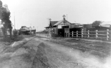
Photograph, Churchill Street, Mont Albert and Mont Albert Station, looking towards Hamilton Street, 1919, 1919
... Churchill Street, Mont Albert and Mont Albert Station...hamilton street... by architect, K W Hardy. The land occupied by the Hamilton Street shops... in Churchill Street, Mont Albert. Mont Albert station is on the RHS...Churchill Street, Mont Albert, Victoria... by the Hamilton Street shops was subdivided in the 1880s and the first ...The railway extended through to Mont Albert in 1882, but it wasn't until 1890 that a station was built with funds raised by a syndicate of local landowners.The buildings on the south side of the railway were built in 1910-1911 in the Arts and Crafts style by architect, K W Hardy. The land occupied by the Hamilton Street shops was subdivided in the 1880s and the first purpose-built shop was 'Pope and Moran, Grocers'. This shop later became Tom Morris' Grocery. By 1930 shops stretched along both sides of Hamilton Street and part way along Churchill Street. The donor, the late Norman Carter held a significant collection of photos taken around Mont Albert and Surrey Hills, in particular subjects related to the Church of England.Black and white photo taken from the centre of the road in Churchill Street, Mont Albert. Mont Albert station is on the RHS fenced off by a post and rail fence. Shops can be seen at the intersection of Hamilton and Churchill Streets. There do not appear to be any shops in Churchill Street. There are newly planted street trees within paling guards on the LHS. There does not appear to be any curb and channelling at the side of the road.Rear in blue biro in Jocelyn Hall's handwriting "Mont Albert Station 1919".mont albert station, railways, hamilton street, churchill street, shops, arts and crafts style, norman carter