Showing 11515 items matching "maps"
-
 Victorian Aboriginal Corporation for Languages
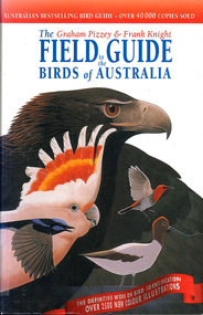
Book, Graham Pizzey et al, The Graham Pizzey &? Frank Knight field guide to the birds of Australia, 1999
Detailed descriptions of Australian native birds at all life stages, including their calls and range of habitat.Maps, colour illustrations, colour photographsbirds, australia, identification -
 Ballarat RSL Sub-Branch Inc.
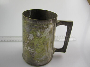
Tankard (Med)
This object relates to James Tennyson BENTLEY. He was born on 05/01/1927 in South Yarra, VIC. James Tennyson served in the Army (VX96171) enlisting on, 23/01/1945 in North Melbourne, VIC before being discharged from duties with the 21 ARMY ORDNANCE DEPOT as a Army Non-Commissioned Private (PTE) on 12/12/1947. James Tennyson BENTLEY was not a prisoner of war. His next of kin is Christina BENTLEY. Brass used for the manufacture of this tankard was salvaged from the battle fields of World War II.Engraved with map - "Persian Gulf Command"second world war (ww2), 1939 - 1945, collectables, ballarat rsl, ballarat -
 Queenscliffe Maritime Museum
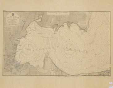
Map - Chart of Geelong Harbour, Geelong Harbour
When Hamilton Hume and William Hovell arrived at the bay in 1824 they met with the local Wautharong people who referred to the bay as "Jillong" and the surround land "Corayo", but by the time the area was surveyed in the late 1830s the Aboriginal names had been swapped. The names "Corayo" and "Jillong" had since been Anglicised to "Corio" and "Geelong".Corio Bay is an important harbour and leisure location in the West and continues to attract development such as the new Tasmania Ferry Terminal.An Admiralty Chart of Geelong Harbour revised in 1954Geelong Harbour Map Ref: 2731geelong, corio, admiralty charts -
 University of Melbourne, Burnley Campus Archives
Plan - Photocopy, Contour Map 1891, 1891
Photocopy of plan showing contour lines from Yarra River. Shows Pavilion and Principal's Residence but not much of the garden design. From Central Plan Office Dept. of Natural Resources."Contour map 1891" written in biroyarra river, pavilion, burnley horticultural college, burnley gardens -
 Victorian Aboriginal Corporation for Languages
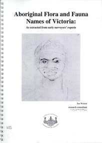
Book, Sue Wesson et al, Aboriginal flora and fauna names of Victoria : as extracted from early surveyors' reports, 2001
The Flora and Fauna Names Project is an initiative of the Victorian Aboriginal Corporation for Languages and the Victorian Biodiversity Strategy. The researcher has examined material from the archives of the Department of Natural Resources and Environment (NRE), the State Library of Victoria, the Victorian Public Records Office and the Australian Archives Office. This first stage of the project focussed on the NRE archives, in particular the field notebooks of the earliest surveyors and their maps although other NRE resources, libraries and public records were accessed. A total of 3028 words were found of which a significant proportion have previously been unknown to linguists. It appears that the place names and word lists in early surveyors notebooks, the 1858 surveyors responses to the Surveyor General and an extensive Wiradjuri wordlist by James Baylis have not yet been widely used or published. Fifteen percent of these 3028 words describe flora and fauna and six percent describe habitat. Of particular interest is the evidence provided by these lists of the existence of fauna in the mid nineteenth century in regions where it is now extinct. For example, magpie geese, eastern quolls, bustards and pademelons were assigned names in the Jardwadjali language area of the upper Glenelg and Wimmera Rivers. The outcomes of this project may help to assist in ascertaining the distribution of flora and fauna assets in Victoria.maps, b&w photographs, colour photographs, illustrations, word listswiradjuri, jardwadjali, glenelg river, wimmera river -
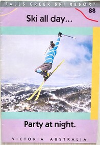 Falls Creek Historical Society
Magazine - Falls Creek Resort - Ski All Day
A part of a yearly marketing magazine program promoting Falls Creek ski region for the winter holidays. It includes 24 pages of detailed information and maps describing resort facilities, different runs and access to the snow. Available accommodation is explained with the inclusion of tariffs for 25 different venues in both lodges and apartments for 1988. Transport, ski hire, other village services and insurance and booking agents are also explained. This item is important as it documents seasonal activities at Falls Creek Alpine ResortMagazine titled "Falls Creek Resort - Ski All Day ....Party At Night". It contains 24 pages of images, information, maps and advertising.falls creek marketing, falls creek 1988, falls creek advertising -
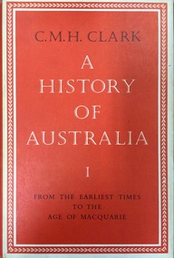 Kew Historical Society Inc
Book, Melbourne University Press, A History of Australia: From the earliest times to the age of Macquarie, 1962
[Carlton, Vic.] : Melbourne University Press ; London ; New York : Cambridge University Press, 1962-<1987> v. <1-6> : ill., maps, ports. ; 24 cm. non-fictionaustralia - history, manning clark -
 City of Kingston
Pamphlet - Colour, J. F. Brady, Matthiesson's Estate, Highett, c. 1905
Sales plan for land in the suburb of Highett, bounded by Tennyson Street, James Street and Point Nepean Road and including Maher Street, Connors Street, Enright Street, Edward Street, James Street and Matthieson Street.The developing urban area of Highett within the City of Kingston. This land sale pamphlet illustrates the subdivision of land within the municipality and the changing demographic of the district as new houses are constructed close to infrastructure.Colour pamphlet advertising for private sale subdivisions in the Matthiesson's Estate, Highett. Incorporates a map of the estate bordered by Tennyson Street, James Street and Point Nepean Road and including Maher Street, Connors Street, Enright Street, Edward Street, James Street and Matthieson Street.Handwritten in blue pencil: x marked on every subdivision on the map Handwritten in grey pencil at the end of the Price List: x not sold Handwritten in grey pencil adjacent to subdivisions 58, 167 and 166: JP. Turner Handwritten in grey pencil adjacent to subdivision 164: [indecipherable] Markings in grey pencil around the edges of the subdivision map Handwritten in grey pencil on reverse: Matthiesson / Matthiesson Estate / Matthiesson Estateland sales, estate, highett -
Whitehorse Historical Society Inc.
Map, M.M.B.W, c1962
... Maps ...Melbourne Metropolitan Area Base Map series sheet 235, covering part, Mitcham, Nunawading and Ringwood areas.Melbourne Metropolitan Area Base Map series sheet 235, covering part, Mitcham, Nunawading and Ringwood areas. Prepared by Department of Lands and Survey and Melbourne and Metropolitan Board of Works from State aerial Survey, June 1957 and Cadastral Survey information, August 1960. Scale 1:4,800.Melbourne Metropolitan Area Base Map series sheet 235, covering part, Mitcham, Nunawading and Ringwood areas. maps, mitcham, nunawading, ringwood, melbourne and metropolitan board of works, victoria. department of lands and survey -
 Ballan Shire Historical Society
Map - Map. Bungal, Department of Lands and Survey, Bungal, County of Grant, 09/09/1926
A map of Bungal in the 1920's showing the allotments, and the size, with the names of the residents. It shows the roads and the Western and Eastern Moorarbool River, and the Whipstick State Forest.Cream coloured map of Bungal in the County of Grant, bounded by the the East Moorarbool River on the East, and the State Forest on the South. It is marked with the scale of chains and the number L.358. Lithographed at the Department of Lands and Survey. Melbourne by W. J. Butson on 9.9.1926. It shows the land allotments with names of owners.Coloured pen marks and circled numbers on various areas. Price 2 shillings marked on bottom right hand edge.bungal, kerrit bareet, egerton, lal lal, borhoneyghurk, bungeeltap, ballark, yaloak, gorong, moorarbool west -
 Ballarat Tramway Museum
Magazine - Australian Railway Enthusiast - Vol 31, No. 1, Jim Seletto, "Memories of the Railway Trams", March 1993
... Maps ...Contains a detailed article on both the VR lines by Jim Seletto, featuring photos of 39, 30, 53, 49, MMTB 675 and a colour photo of VR 49 on the rear. Contains maps and diagrams of St Kilda Station. Includes Sandringham and Black Rock line. Published by the ARE.Provides a light hearted record and view of the VR Railway trams with plenty of stories..Magazine - "Australian Railway Enthusiast - Vol 31, No. 1, March 1993", 24 pages, centre stapled,vr trams, st kilda - brighton tramway, sandringham, black rock, maps, st kilda, tramways, railways -
 Wycheproof & District Historical Society Inc.
Bunguluke Map, Bunguluke District In 1923, 27.2.1923
By 1881 Bunguluke was a small settlement as recorded, December 5, in the Charlton "Mercury". It reports that in that year Draper's Store, Hotel and Post Office and residence at Bunguluke North was totally destroyed by fire. For years now there has been little sign of community life with houses few and far between and acreages have gone into larger holdings. The map references land blocks and owners for that era.This important map shows the local land ownership and local features that existed in 1923. This is a photocopied black and white map of Bunguluke in the County of Kara Kara, Number L5149. Marked - Photo Lithographed by W.J. Butson 27.2.1923. The details include numbers of allotments, property owners, roads, rivers. The boundaries marked are the Parish of Jeruk, Parish of Wycheproof, Parish of Cooroopajerrup. Wycheproof township location is shown with the Scale of Chains. Bunguluke maps for other years are also in the collection.map, bunguluke, jeruk, wycheproof, cooroopajerrup -
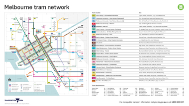 Melbourne Tram Museum
Map, Transport for Victoria, "Melbourne tram network", Feb. 2018
... Maps ...Digital Image of the Feb. 2018 version of the tram and route map for Melbourne titled "Melbourne tram network". Published by Transport for Victoria, effective May 2017 following changes to routes, in particular route 58. Shows each of the route, terminal points, with a legend. Note does not have Yarra Trams logo.trams, tramways, maps, transport for victoria, melbourne, routes -
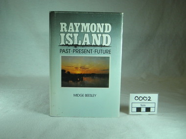 Raymond Island Historical Society
Book, Midge Beesley, Raymond Island:past present future, 1986
Local history of Raymond Island. Includes stories of Island identities, maps, photographsLocal significance Out of print publicationMonograph publication 291 pages Hardback Loose cover Maps Sunset picture of lake from Raymond Island on front cover Photographs of people, buildings, Raymond Island ferries, boats. Contents: Raymond Island early settlers, indigenous history, Island identities, Raymond Island State School, a'Beckett Park, Raymond Island Ferry, The Presbyterian Church, raymond Island Advancement League park, gippsland lakes, raymond island, raymond island state school, a beckett, raymond island ferry, early, settlers, raymond island advancement league -
 Melbourne Tram Museum
Ephemera - Map - Timetable, Melbourne & Metropolitan Tramways Board (MMTB), "Map and timetable of Melbourne Tram and Bus Services", March 1952
Map provided information about Melbourne's tramway network in 1952. At base of map - timetable of all night trams and bus services. On rear index to routes, 1st and last services, time of Sunday am services, Latrobe St. services and photo of Wattle Park. The conversion of Bourke St to electric trams marked up. Copy 1 - has been marked for hypothetical extensions in blue pencil mainly in the northern and western suburbs. In particular note the Ballarat Road and South Road markings. Copy 2 - has been marked up for newer route numbers, following the opening of the Bourke St services and additional route numbers on the Essendon Depot lines. Demonstrates the provision of information about Melbourne tram services.Fold out map (10 sections - 2 high x 5 wide), coloured of Melbourne's Tram and Bus routes, route numbers, rail lines, municipalities boundaries and location of major places of interest. melbourne, tram and bus services, mmtb, buses, trams, routes, timetables, all night services -
Whitehorse Historical Society Inc.
Map, Plan of the Parish of Nunawading, 1853
... Maps ...Photocopy of map showing names of selectors, also list of references to the corners of allotments.Photocopy of map showing names of selectors, also list of references to the corners of allotments. Note on verso:'Gardiners Creek, Ballyshanassey township surveyed by H. Parmein, Surveyor General's Office Nov 30, 1853 also Reference to the Corners of allotments' (Plan 428)Photocopy of map showing names of selectors, also list of references to the corners of allotments. land subdivision, gardiners creek, ballyshanassy, parmein, h, burwood east, maps -
Kew Historical Society Inc
Book, Doubleday, Australia Twice Traversed : The romance of exploration being a narrative compiled from the journals of five exploring expeditions into and through central South Australia and Western Australia from 1872 to 1876. Vol.1, 1986
Facsim. reprint. Originally published: London : Sampson Low, Marston, Searle and Rivington, 1889. Ferguson no. 9914. Giles stayed with T.S.Gill in Walpole St. See Dorothy Rogers2 v. (lix, 320 p., [13] leaves of plates (3 folded); x, 363 p., [13] leaves of plates (3 folded) : ill., maps ; 22 cm. non-fictionFacsim. reprint. Originally published: London : Sampson Low, Marston, Searle and Rivington, 1889. Ferguson no. 9914. Giles stayed with T.S.Gill in Walpole St. See Dorothy Rogersaustralia -- central -- discovery and exploration. -
![An account of the English colony in New South Wales : with remarks on the dispositions, customs, manners, &c. of the native inhabitants of that country, to which are added, some particulars of New Zealand / compiled, by permission, from the Mss. of Lieutenant-Governor King by David Collins [Volume 2]](/media/collectors/550653872162f11fb04854aa/items/575ba131d0cdd1229c1ff2b1/item-media/57600fbed0cdd1199076abab/item-fit-380x285.jpg) Kew Historical Society Inc
Kew Historical Society IncBook, Libraries Board of South Australia, An account of the English colony in New South Wales : with remarks on the dispositions, customs, manners, &c. of the native inhabitants of that country, to which are added, some particulars of New Zealand (Vol. 2)], 1971
[Adelaide : Libraries Board of South Australia, 1971] 2 v. : maps (part col.), plates (part col.) ; 28 cm. Australian Facsimile Editions No.76. Volume 2non-fictionnew south wales - descriptions and travel, new zealand - descriptions and travel -
 Federation University Historical Collection
Programme, School of Mines: 75th Anniversary, Directory for Open Night, 1945, 1945
To celebrate the 75th Anniversary of the School of Mines and Industries an Open Night was held on Thursday, October 25 (1945) from 7 to 9.15 p.m. The Principal was Mr A Heseltine and the Registrar was Mr F Ferguson. Members of the School Council included E J Tippett, M G Beanland who have a building or walkway named after them. A map of the buildings shows the various areas and information is given for each department. Though it was an Open Night it would also serve as an Information Night for student enrolling for the following year.Paper folded in half and printed on each of the four sections. Map showing layout of buildings. Information on each department of the school.ballarat school of mines and industries, 75 anniversary, a heseltine, principal, f e ferguson, registrar, e j tippett, m g beanland, open night, information night -
 City of Greater Bendigo - Civic Collection
Document - Set of correspondence re Queen Elizabeth tour of Bendigo, Mrs T. R. Mannix, February 8th, 1954
Correspondence between Mrs T. R. Mannix, Swan Hill Wolf Cub Pack master to District Scout Commissioner Mr J. I. Samson for an invitation to be included with the local scout groups in functions to welcome Queen Elizabeth and the Duke of Edinburgh to Bendigo on Friday, the 5th of March 1954. The response from the Commissioner included typed plans of the event and maps of the royal tour through the streets of Bendigo starting and finishing at the train station.Set of correspondence including typed gatefold letter, typed plans for placement of visitors and role of the military and maps of CBD Bendigo and of Upper Reserve.queen elizabeth, duke of edinburgh, boy scout association, mayor clayton, city of greater bendigo royal visits, city of greater bendigo community groups, city of greater bendigo tourism -
 Greensborough Historical Society
Map, Melbourne and Metropolitan Board of Works. Survey Division, MMBW, Yarra 2500 / 12.20. Watsonia Railway Station and environs, 1983_03
Melbourne and Metropolitan Board of Works. Yarra 2500 [base map]. 12-20, Parishes of Keelbundora 2856, Municipalities of Diamond Valley 257 and 228. Shows street names, easement sizes, lot numbers, lodged plan numbers, names of prominent features, contour values, creek or river names. Watsonia Railway Station and environs. Prominent streets: Watsonia Road, Elder Street, Morwell Avenue and Nepean Street. Includes former Watsonia Technical School and Gresswell Rehabilitation Centre sites.MMBW Map in 1:2500 [scale] series. Cream parchment with green tape reinforcing on edges and punched holes on left edge.mmbw, melbourne and metropolitan board of works, shire of diamond valley, watsonia - maps -
 Greensborough Historical Society
Map, Melbourne and Metropolitan Board of Works. Survey Division, MMBW, Yarra 2500 / 12.21. Watsonia North, 1979_02
Melbourne and Metropolitan Board of Works. Yarra 2500 [base map]. 12-22, Parish of Keelbundora 2856, Municipality of Diamond Valley 257. Shows street names, easement sizes, lot numbers, lodged plan numbers, names of prominent features, contour values, creek or river names. Watsonia Railway Station and environs. Prominent streets: Grimshaw Street, William Street and Macorna Street. Includes former Institute of Social Welfare (now Loyola College) Lines Reserve and Binnak Park.MMBW Map in 1:2500 [scale] series. Cream parchment with green tape reinforcing on edges and punched holes on left edge.mmbw, melbourne and metropolitan board of works, shire of diamond valley, watsonia - maps, bundoora - maps -
Whitehorse Historical Society Inc.
Map, Site for Wesleyan Church, Nunawading, 1855
... Maps ...Photocopy of manuscript map showing names of landholders.Photocopy of manuscript map showing names of landholders. Note on verso: Plan of allotments in the City of Melbourne appropriated to the Wesleyans. Site for Wesleyan Church, Nunawading 1848 (Corner of Burwood and Elgar Roads - S of Burwood, W of Elgar)Photocopy of manuscript map showing names of landholders. churches, wesleyan church, burwood, burwood road, burwood, elgar road, burwood, maps -
Whitehorse Historical Society Inc.
Map, Burwood Road, Box Hill City, 15/02/1952 12:00:00 AM
... maps ...Detailed map of subdivision along the north side of Burwood Road, Box Hill between Station Street and Middleborough Road.Detailed map of subdivision along the north side of Burwood Road, Box Hill between Station Street and Middleborough Road. Shows many block owners, types of buildings, nature of fencing. Marked as 'Survey Plan No 5440'.Detailed map of subdivision along the north side of Burwood Road, Box Hill between Station Street and Middleborough Road. maps, burwood road, burwood, andrews street, greenwood street, tennyson street, middleborough road, station street -
Glen Eira Historical Society
Map - CAPLES PLACE SUBDIVISION
... Maps ...This file contains a copy of a map of the CAPLES PLACE SUBDIVISION, undated and author unknown. The map provides the dimensions of roads and allotments in the area, including also handwritten notes from the original document and others written directly onto the copy.land subdivisions, documents, maps, glen eira, caples place, caples place subdivision, land surveys, orrong road, mulgrave road, prahran grove, somerset road, prahran grove, prahran grove, east walk, land allotments, town planning, garden road -
4th/19th Prince of Wales's Light Horse Regiment Unit History Room
Map, Victoria, 3rd Military District, 3rd and 5th Brigades of 2nd Cavalry Division, 1 January 1921
The 4th/19th Prince of Wales's Light Horse Regiment is now the only Victorian Light Horse Regiment and the custodian of the histories of the six Light Horse regiments depicted on the mapColoured print of map (2 copies) showing Victorian Light Horse regimental areas of 3rd and 5th Brigades of 2nd Cavalry Division. 5th Brigade: 4th, 19th, & 17th Light Horse Regiments 3rd Brigade: 20th, 8th & 13th Light Horse RegimentsIssued by authority of the District Commandant -
 Orbost & District Historical Society
book, Broadbent's Melbourne - Sydney Guide Book, 1936
Broadbent's Official Road Guides Company took over George R. Broadbent's business in 1935. In 1963, it changed its name to Broadbent's Road Maps Pty. Ltd. George Robert Broadbent (1863-1947), cyclist and map publisher, was born on 3 November 1863 at Ashby near Geelong, Victoria. At various times Broadbent held most Victorian and Australian road cycling records. Broadbent became an active vice-president of the Good Roads Association of Victoria in November 1912 and was consulted regularly during the preparation of the country roads bill. That year he took over the Argus motoring column, wrote tirelessly on road improvements and maintenance, and became manager of the Automobile Club's new touring department in 1914.A 160 pp road guide book titled Broadbent's Official Road Guide Melbourne - Sydney. The front cover has a yellow background with a map of the coastline from Sydney to Melbourne, the Prince's Highway route marked. This is inset in a drawing of a car driving along the coastal road.The book contains speedometer readings, route maps, advertisements and photos of points of interest. In the top right is the logo of the Royal Automobile Club of Victoria and at the bottom right is the price 1/-.traavel road-guides broadbent-george car-touring -
Whitehorse Historical Society Inc.
Map, Parishes of Bulleen, Boroondara, Prahran and Nunawading, 1850
... Maps ...Photocopy of map and tables of corners of allotments.Photocopy of map and tables of corners of allotments. Note on verso: Nunawading, Boroondara, Prahran. Allotments in the Parish surveyed by Lindsay Clarke 1850 (note by Robert Hoddle, surveys by Unwin, Elgar and Dendy indicated)Photocopy of map and tables of corners of allotments. maps, parish of bulleen, parish of boroondara, parish of prahran, parish of nunawading, clarke, lindsay, hoddle, robert -
 National Vietnam Veterans Museum (NVVM)
Souvenir - Cap, peaked
This item was collected because it has been signed by Sir Peter Cosgrove MC, Patron on the National Vietnam Veterans Museum. He served as a Lieutenant in Vietnam :1 Australian Reinforcement Unit 02 Aug 1969 -19 Aug 1969, 9th Battalion, The Royal Australian Regiment 20 Aug 1969 -28 Sep 1969,Headquarters, 1st Australian Task Force 29 Sep 1969 - 30 Jul 1970. It was donated by National Serviceman R V Williams, a private who served under Lieutenant Cosgrove.Bottle green peaked cap with a tan brim. Embroidered. Signed in black felt pen by Peter Cosgrove.Vietnam/ Map of Australia/Vietnam 4 color bar crossing the map/ Vietnam Veterans Australia/ signature of Peter Cosgrove.souvenir, vietnam veterans cap, sir peter cosgrove signature, cosgrove, williams, r v williams -
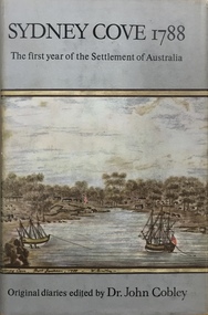 Kew Historical Society Inc
Book, Hodder & Stoughton, Sydney Cove 1788: The first settlement of Australia / by John Cobley (ed), 1962
Day-to-day account of the events of the first year; texts taken from historical records & mss; briefly mentions contacts with natives in districts, physical description.London : Hodder and Stoughton, 1962 296 pages, 4 unnumbered leaves of plates, 8 unnumbered pages of plates : illustrations (some colour), maps ; 23 cm non-fictionDay-to-day account of the events of the first year; texts taken from historical records & mss; briefly mentions contacts with natives in districts, physical description.sydney (nsw), australian history - sydney 1788