Showing 1282 items
matching back creek
-
 Orbost & District Historical Society
black and white photograph, C 1890s
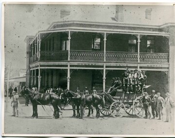
The first hotel built in Orbost was the Club in 1885 an old wooden place on the corner built for J. A. Petersen of the Mitchell Hotel Bairnsdale, with the licence in the name of Mr Thomas Maguire (stepson of Petersen). William Archer was the proprietor at the time of the photograph. The coach driver was Sam Dyer and the coach is leaving for the goldfields at Combienbar. In June 1889 there was a rush to Mackenzie River, about 28 miles from Orbost, on Twelve Mile Creek. An estimated 80 men rushed the ground, but yields were patchy and large numbers eventually left. They were coming and going almost daily.The Club Hotel was the first hotel built in Orbost and remains a significant building in the town. It was an important hub for the township with many whole town meetings held there.A faded black / white photograph (with two copies) with a horse-drawn carriage loaded with men and the Orbost Club Hotel behind them. The photo is on a grey buff card.on back - " H. Adams. Driven by Sam Dyer - Leaving for the Combienbar Goldfields"orbost-club-hotel combienbar-goldfields -
 Orbost & District Historical Society
black and white photograph, late 19th - early 20th century?
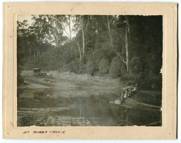
Bunga Creek is approximately 5km east of Lakes Entrance.This is a pictorial record of horse-drawn transport of the late 19th century used in East Gippsland.A black / white photograph of a bush scene with a horse - drawn coach running along a track beside a creek.. It is on a cream coloured buff card.on back - "No. 5" on front - "At Bunga Creek"bunga-creek horse-drawn-coach -
 Orbost & District Historical Society
black and white photograph, 1924
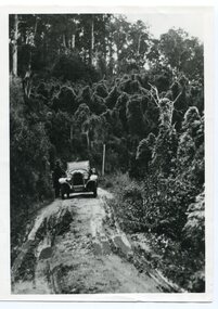
History unknown. Oswald Stuart Green taught at the Bete Bolong State School in the 1920s /30s. He wrote many books about East Gippsland including several on thee Orbost / Marlo district.Oswald Green has an association with the Orbost area.A black / white photograph of a dirt road in the bush with a motor vehicle on the road and a man standing beside it.on back - " O.S. Green 31 Malcolm St Blackburn Princes Highway east of Coolwater Creek."princes-highway-coolwater-creek green-oswald-stuart -
 Orbost & District Historical Society
black and white photograph, first half 20th century
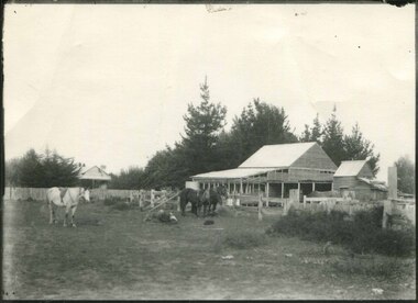
Mr John Watt set up farming in 1879. He was a native of Port Fairy. He was educated in Scotland and came back to Victoria and selected 320 acres on the Snowy River.The property extended from Majors Creek Road to around about Gilbert's Gulch.This is associated with John Watt, a prominent early settler in Orbost.A black / white photograph of a dilapidated farm shed with three horses in the foreground. A house can be seen in the background (left) behind a fence. on back - "Watts Farm"watt-john-orbost farming-buildings -
 Orbost & District Historical Society
black and white photograph, 1918
... on back - "Bridge at Tonghi Creek 1918"...-gippsland on back - "Bridge at Tonghi Creek 1918" A large black ...Tonghi Creek is 66km north - west of Orbost. Prior to the sealing of the Princes Highway west of Orbost, the road surface was anything but good, even by C1917 when cars started to use the road. From Orbost the old road via Marlo to Sydenham was abandoned for the new location which traversed more rugged country via Cabbage Tree, Bell Bird and Club Terrace to Cann River, and the reason for this diversion was on account of settlements being established at Murrungowar and Club Terrace, at which latter place there was a temporary rush to obtain gold. This road was constructed by the Public Works department and a maximum grade of 1 in 19 was adopted, and as speed was not to be catered for the grade followed in and out round the spurs and gullies, resulting in a maze of turns and twists which required a good deal of skill on the part of the horse driver to negotiate." - Bairnsdale Advertiser, Friday, May 2, 1947. (More information from Newsletter February 2010)This item is a pictorial record of roads in the early 20th century in East Gippsland.A large black / white photograph of a bridge over a small creek, surrounded by bush. The photograph is mounted on a thick cream coloured card.on back - "Bridge at Tonghi Creek 1918"tonghi-creek-bridge country-roads-east-gippsland -
 Orbost & District Historical Society
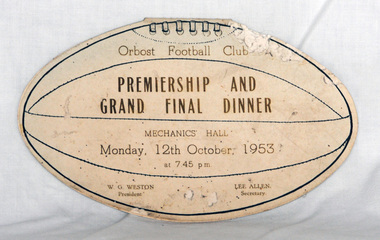
invitation, 1953
This was an invitation to the Premiership and Grand Final Dinner. The invitation belonged to Mrs R. Smith, 20 Raymond Street, Orbost, 3888. Roma Smith (nee Cameron) was the daughter of Harry Purchase Cameron and Lilian Gladys (nee Harding. Roma married Ronald Richard SMITH in 1944 Harry's father, James Cameron, came to Bellagoogan on Majors Creek in 1882. Bellagoogan was on Majors Creek near Orbost and was the site of the first race course. Like many others at the time, the Camerons bred race horses.Harry died in 1964 aged 75.Orbost Football Club through its many changes has always been an important social fabric of the Orbost community. Sport is often regarded as an important part of life in rural Australia, contributing to community identity, sense of place, social interaction and good health.A cardboard invitation in the shape of a football. It has a menu inside and a program for the evening. on the back is a list of the team players for both teams.invitation orbost-football-club recreation sport -
 Orbost & District Historical Society
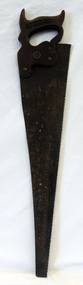
handsaw, !930's
Donated by the Harry Cameron family, Harry's father, James Cameron, came to Bellagoogan on Majors Creek in 1882. Bellagoogan was on Majors Creek near Orbost and was the site of the first race course. Like many other at the time, the Camerons bred race horses.Harry died in 1964 aged 75.Hand saw with a skew-back, steel blade and a wooden handle. It has three metal saw pins and a medallion marked 'warranted superior'. There is a chip carved wheat sheaf decorating the front hand grip. This handsaw is probably a Disston Keystone K-4 Air MasterOn a metal disc around a keyhole is "Warranted Superior".tool timber-industry handsaw -
 Orbost & District Historical Society
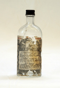
bottle, Probably WW11
Joseph Bosisto was a Yorkshireman who had qualified as a Pharmacist in Leeds and London. He arrived in Adelaide in 1848 at the age of 21. In 1851 he moved to Victoria in search of gold, but instead opened a pharmacy in Richmond, where he built a laboratory to investigate the chemical and medicinal properties of Australian plants. As a result of the collaboration with von Meuller the essential oil industry of Australia began in 1852, when Bosisto commenced operations in a small, rudely constructed still at Dandenong Creek, Victoria, using the leaves of a form of E. radiata (then known as E. amygdalina) which grew profusely in the district. Bosisto soon built other distilleries at Emerald, Menzies Creek and Macclesfield. World War II soldiers packed it in their mess kits to keep foot fungus in the tropics at bay. Small clear glass Eucalyptus Oil bottle with metal screw lid and large label on front.Front Label - War Time Pack Back - This bottle remains property of J Bosisto &Co Pty Ltd Richmond Victoria Bottom-F1196bottle eucalyptus-oil bosisto-joseph -
 The Beechworth Burke Museum
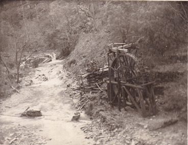
Postcard, 1920
This postcard depicts the set-up of an abandoned gold mine. This includes a water wheel and other mining implements next to a creek. The postcard inscription indicates that this image is of the remains of the Wallaby Reef battery and water wheel. Wallaby Reef was discovered in 1864, and a prospecting claim established a four head battery and water wheel. Quartz was mined there, with gold also discovered at this location at a later date. By 1878 the mine was no longer resulting in rich deposits, this resulted in the miners moving their search for gold closer to the river where they were able to access more gold. This was in approximately 1879. In 1882 a rich deposit was found. In 1908 the battery was closed, and the mine finished. This photo was taken in 1920 and shows the deterioration of the site since its closure. Gold mining was crucial to the development of the Beechworth area. It has strong research and historical value because the clarity of the photo shows all the minute details of the mining equipment. The text on the back also indicates the mine is the Wallaby Mine, which was used for 45 years to find gold and quartz. Therefore, due to the location being quickly abandoned, this site is a rich location for historical study on gold mining during the 1900s. It can provide important information on the types of tools utilised and the impact of the mining on the environment.Black and white postcard photograph on card.8169 Be / Also near Wallaby Reef Workings / Relics of Rechabite Reef (locality) workings. / Shaft in bed of creek. Wheel used to drive sheadd (?) / stamp battery too I believe near B'worth 1920?beechworth, mining, gold mining, quartz mining, wallaby reef mine, mine battery head -
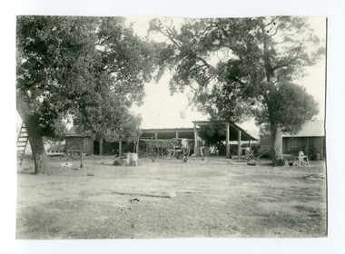
 Orbost & District Historical Society
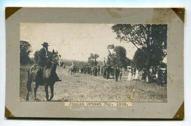
black and white photograph, 1899
This photograph shows spectators watching the Orbost Races on the flat in 1899. Some of the earliest horse races were held on a course in a paddock belonging to Mr James Cowell at Jarrahmond. For a long time horse races were part of the Marlo Picnic Races. Bellagoogan on Majors Creek near Orbost was the site of the first race courseThis item is a pictorial record depicting the popularity of horse racing in Orbost in the late 19th century.A black / white photograph on a grey buff card. It is of a man on a horse holding a whip in his right hand. A horse with jockey is approaching. Spectators are standing on the right hand side under the trees.on front - "Finish Orbost Cup 1899: on back - "Mr Edlington"horse-racing-orbost sport recreation -
 Orbost & District Historical Society
black and white photograph, 1920's -1930s
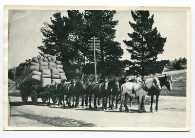
The photograph shows the wagon and team owned by Mr Tom Malinn of Sardine Creek. On lst Juy 1926, Tom Malin took over the horse drawn coach run from Orbost to Delegate. After a few years he obtained an International 2-3 ton truck. On his first trip to Bendoc he did not carry mail, but brought Miss Cunning, the first lady head teacher and collected ballot boxes. On his next trip (March 1930) he made history as the first mailman on this route to deliver mail in a motor vehicle. (info. Bendoc History) Tom and Sophie Malinn farmed at Martin’s Creek. Sophie (nee Jensen) married Tom Malinn in 1926. Sophie’s family had run the historic “Danebo Hotel” at Martin’s Creek for many years, and in 1931, Tom and Sophie began farming at Martin’s Creek, initially cropping maize and beans. This is a pictorial history horse-drawn transport used widely in Orbost until the late 1920sA black / white photograph of a large wagon loaded with wool bails being pulled by a team of horses. a man is standing behind the horses in the background.on back -"Tom Malinn with wool from Bonang"malinn-tom-bonang transport-horse-drawn -
 Orbost & District Historical Society
black and white photograph, first half 20th century
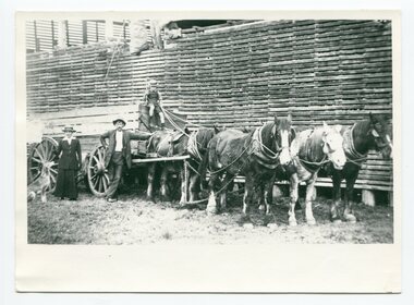
Mr John Watt set up farming in 1879. He was a native of Port Fairy. He was educated in Scotland and came back to Victoria and selected 320 acres on the Snowy.The property extended from Majors Creek Road to around about Gilbert's Gulch.This is associated with John Watt, a prominent early settler in Orbost.A black / white photograph of a horse-drawn wagon with a man, lady and a dog standing beside it. There is a young boy holding a whip sitting on top of the wagon. Behind the wagon is a large wooden slatted barn.on back - " a farm down Marlo Rd - Watts)farmhouse transport-horse-drawn watt-john -
 Orbost & District Historical Society
black and white photograph, 1892
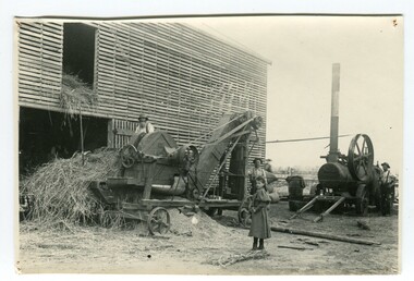
The photograph shows a chaff cutter on John Watt's farm about 1892. Mr John Watt set up farming in 1879. He was a native of Port Fairy. He was educated in Scotland and came back to Victoria and selected 320 acres on the Snowy River.The property extended from Majors Creek Road to around about Gilbert's Gulch.this item is associated with John Watt an early Orbost settler.A black / white photograph of a large wooden slatted barn with motorised farm machinery outside . There are three men with the machines and a young girl watching.agriculture-machinery farming-orbost watt-john -
 Orbost & District Historical Society
black and white photograph, early 20th century
Mr John Watt set up farming in 1879. He was a native of Port Fairy. He was educated in Scotland and came back to Victoria and selected 320 acres on the Snowy River.The property extended from Majors Creek Road to around about Gilbert's Gulch.The Watt family settled in Orbost as farmers being one of the first farming families in the district.A black / white photograph showing wooden farm sheds and wagons. a small wooden house is on the right hand side and there are tall trees in the fioreground.on back - Mrs Watts farmwatt- farm agriculture-buildings -
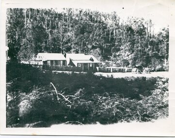 Orbost & District Historical Society
black and white photograph, late 19th century - early 20th century
... gippsland Sardine-Creek on back - Boarding House at Sardine Creek ...A black / white photograph of an early settler's home on a small clearing in bushland.on back - Boarding House at Sardine Creeksardine-creek -
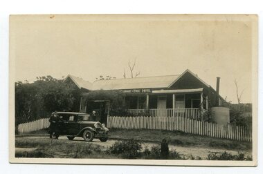 Orbost & District Historical Society
black and white photograph, 1920s -1930s
The Cabbage Tree Creek township was originally established to support the booming timber industry of the mid 20th century. Five timber mills worked full time supporting the families that were drawn to the area's wealth of natural resources. The settlement of Cabbage Tree Creek is located on the Princes Highway, 27 km east of Orbost in East Gippsland. The first white settler arrived in the valley in 1887 cutting a dray track from Marlo to the south-west. Several families cleared the alluvial flats, growing maize, peas and beans and raising pigs, cattle and sheep. Later the farmers milked cows, sending cream to Orbost. In the late 1890s, small quantities of alluvial gold were found in the creek. A school commenced classes in 1913, but enrolment was small and at times the school operated part time with several other small schools in the area. The school building served as a hall for the district. From the 1920s the Cabbage Tree Hotel catered to drivers on the improved Princes Highway. (info. from Victorian Places)This is a pictorial record of Cabbage Tree, East Gippsland in the late 20th century. It shows a building that no longer exists.A small black / white photograph of a single storey timber building. On a sign below the roof is "Cabbage Tree Hotel". The hotel is surrounded by a wooden picket fence. A man and woman are standing on either side of a motor car parked on the roadway in front of the building.on back - on label - Cabbage Tree Hotelcabbage-tree-hotel -
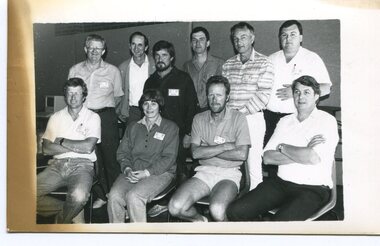 Orbost & District Historical Society
black and white photograph, Snowy River Mail, October 1987
This a photograph of the Gippsland representatives at the C.A.T.S. conference. This photograph was taken at the Curriculum and Technology in Schools workshop held in Bendigo, Victoria in October 1987. Eighty rural primary schools were involved including many from East Gippsland. From the Snowy River Mail; " A large number of technologies was......demonstrated at the conference. Participants were given hands on experience with audio and computer conferencing, CD Rom. an Invicon booth ( individual video console (INVICON) enables any teacher to produce short, relevant teaching videos for individual pupils without assistance), packet radio, videodisk, robotics and many more...." In the back row are: Al Balfour (Bairnsdale Min of E); Graeme Rodier (OHS); Roger Nink (Swifts Creek); John Hillier (Mallacoota); Barry Lay ( Bairnsdale HS); Ross Burn ( Bairnsdale HS), In the front row are: Jeff Wilson (Mallacoota); Bea Lay (Bairnsdale HS); Rick Box ( Swifts Creek) and Brian Pomeroy (AVRB Bairnsdalel). Al Balfour was a noted educator, local identity and one of country Victoria's strongest advocates.This is a pictorial record associated with education in East Gippsland.A black / white photograph of a group of people. The back row is standing and the front is sitting on chairs.education-east-gippsland technology -
 Orbost & District Historical Society
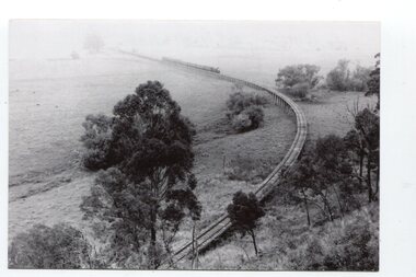
black and white photographs, Jude, Ray, 1915 - 1969
... 3103.1 on back - " Orbost- Snowy River flats viaduct 22-2... - on back - " Nowa Nowa Boggy Creek Bridge A.R.H.s. Orbost tour Ray ...These photographs relate to the East Gippsland Railway. The Bairnsdale-Orbost railway was opened in 1916 to serve the agricultural and timber industry. Because of the decline in traffic and heavy operating costs, the line was finally closed in August, 1987. Orbost Railway Station was opened on Monday 10 April 1916 as the terminus of the Orbost railway line, and closed in 1987. The station was located on the west side of the Snowy River despite the town of Orbost being on the east side of the river, in order to save on the costs of a bridge over the river, which at the time had highly variable levels. These photographs are associated with the history of the Orbost-Bairnsdale railway line and therefore reflects the role that the rail line played in the social and economic history of Orbost.Seven black / white photographs and one postcard print.3103.1 on back - " Orbost- Snowy River flats viaduct 22-2-1964 ARHS special train Ray Jude photo" 3103.2 - on back -" Orbost Snowy River flats viaduct A.R.H.S. special train 22.2.1969" 3103.3 - on back - " A.R.H.S. special across bridge between Waygara & Nowa Nowa 22-2-1964 3103.4 - on back - " Nowa Nowa Boggy Creek Bridge A.R.H.s. Orbost tour Ray Jude photo" 3103.5 - on back - " Orbost 22-2-1969 SM office & goods shed Ray Jude photo" 3103.6 - on back - " Orbost Railway Yards - 22 February 19369 Ray Jude photo" 3103.7 - on back - " Orbost May 27 -1936 Orbost Rail Station" 3103.8 - on front - caption - Unloading Ballast Orbost line near Newmerella 1915 - J. Sullivan Colin ?orbost-railway east-gippsland-railway bairnsdale-orbost-railway -
 Ringwood and District Historical Society
Newspaper, The Mail, Obituary - Joseph Richard Sanders - Old and Respected Pioneer Ringwood 1959 from the Ringwood Mail, 1959
The article was contributed by J.K.McCaskill, JP. a mayor of Ringwood in the years between 1924-1951.The Sanders family came from England and are mentioned in the book "Ringwood a Place of Many Eagles" by Hugh AndersonObituary from The Ringwood Mail of Joseph Richard Sanders of 18, Wantirna Road, Ringwood, aged 87 years. He came from a family who were early pioneers of Ringwood. he was born in Collingwood but schooled in Ringwood, married and brought up his family in Ringwood. He lived at 18, Wantirna Road .The article was contributed by J.K.McCaskill, JP. a mayor of Ringwood in the years between 1924-1951.Transcript: "The death occurred of Joseph Richard Sanders, 18 Wantirna Rd, Ringwood, on Wednesday, 21st October 1959, in his 87th year, marks the passing of another of Ringwood’s early pioneers. He was born in Collingwood in August 1873 and came to Ringwood with his parents when 15 months old. They made their home on land on what is now known as Jubilee Park (Fuller particulars of this Park will appear in ‘The Mail’ at a later date, also reference will be made to Wantirna Rd, in the early days it was known as West Prussia Rd). Joe went to the school held in the old homestead and orchard of Mr. Mills, just through the Heatherdale Road railway gates. He remembered many of the scholars, some of the boys and girls had to walk three and four miles to school through rough scrub paddocks in all kinds of weather. During the lunch hour a few of the boys generally went to the creek to fish for eels and would be late in getting back to school, greatly to the annoyance of the teacher. One day the fishing was good, and the boys rather reluctantly returned to the school late as usual. The teacher was furious and made them stand in front of the class but before inflicting punishment she called out to one of the boys to throw out that dirty bag he was holding. The lad gave the bag a shake and out wriggled a snake. There was immediately a general stampede from the classroom, led by the teacher. The school was closed for the rest of the afternoon. Another incident related to a few tramps who after the scholars had all gone home, generally camped for the night in an old back room in the homestead. One of the boys put a little gunpowder in this old fireplace and when the tramps lit the fire to boil their billies the old chimney and part of the old wall just collapsed. Joe, after leaving school, worked around the district for some time and later left Ringwood to live in other suburbs. He at one time was employed at the Aust Glass Works, and later as a carpenter worked on building the dome of the Railway Station at Flinders St. He married a Miss E. M. Wood in 1901 at Richmond and a few years afterwards returned to Ringwood and resided at No. 18 Wantirna Rd., where he reared a family' of three girls (Alice, Ethel, Joyce) and two boys (Robert and Joe). Joe recalled many interesting events of earlier years, such as the duplication of the railway line, and the cutting back of the embankment at the Goods Shed, the earth being used to heighten up the railway bridge over Wantirna Rd. The brickworks at Ringwood East and reference to early land surveys, the using of the heavy chain links before the use of the theodolite became general, and the many neighbours and friends whom he knew. He was interested in local public affairs and was fond of fishing. He proved himself a good citizen and was highly respected and esteemed throughout the district, and so another old pioneer passes on." (Contributed by J. K. McCaskill, J.P.) RM 19 Nov 1959 -
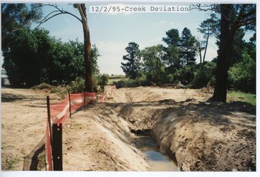
 Ringwood and District Historical Society
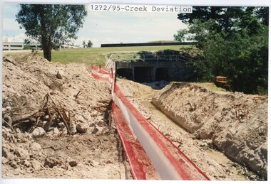
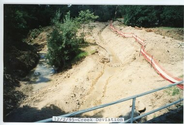
photograph, Eastlink Ringwood Bypass Construction-12/2/95-Creek Deviation
Colour photographWritten on back of photo: "12/2/95-Start of Bypass-Creek Deviation" -
 Ringwood and District Historical Society
photograph, Eastlink Ringwood Bypass Construction-12/2/95-Creek Deviation
Colour photographWritten on back of photo: "12/2/95-Start of Bypass-Creek Deviation" -
 Ringwood and District Historical Society
photograph, Eastlink Ringwood Bypass Construction-12/2/95-Creek Deviation
Colour photographWritten on back of photo: "12/2/95-Start of Bypass-Creek Deviation" -
 Ringwood and District Historical Society
photograph, Eastlink Ringwood Bypass Construction-Ringwood Bypass Creek Diversion
Colour photographWritten on back of photo: "11/3/95 Bypass-Creek Diversion" -
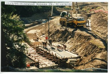
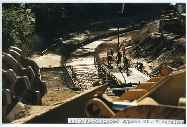 Ringwood and District Historical Society
photograph, Eastlink Ringwood Bypass Construction-Ringwood Bypass Creek Diversion 11/3/95
Colour photographWritten on back of photo: "11/3/95 Bypass-Creek Diversion" -
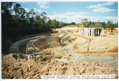 Ringwood and District Historical Society
photograph, Eastlink Ringwood Bypass Construction-Ringwood Bypass Creek Diversion 15/4/95
Colour photographWritten on back of photo: "Ringwood Bypass 15/4/95 Mullum-Mullum Ck Diversion" -
 Ringwood and District Historical Society
Photograph, The Mullum Mullum Creek track, the oak tree at back of library on 10th September 1989, 1989
Digital photograph -
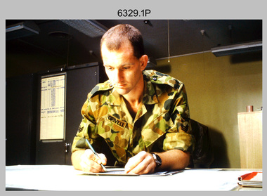 Bendigo Military Museum
Photograph - Tasks Demonstrated by Royal Australian Survey Corps Technicians, c1990s
This is a set of 17 photographs of technicians from the Royal Australian Survey Corps undertaking technical tasks circa 1990s. Photos .1P to .9P were taken at the Army Survey Regiment, Fortuna, Bendigo. Photos .10P to .15P and .17P of students operating survey equipment, were taken at the School of Military Survey, Bonegilla and survey stations surrounding Lake Hume. The base camp at photo .16P was probably taken at Sandy Creek, near Tallangatta Victoria, during the field phase of a basic or advanced RA Svy training course. CPL Steve Nokes appearing in photo .17P was attending the 1/90 Map Control Survey Course.This is a set of 17 photographs of technicians from the Royal Australian Survey Corps undertaking technical tasks at the Army Survey Regiment, Fortuna, Bendigo, and the School of Military Survey, Bonegilla c1992. Colour photos are on 35mm slide film and were scanned at 96 dpi. Photo .17P is in black & white, printed on photographic paper and scanned at 300 dpi. The photos are part of the Army Survey Regiment’s Collection. .1) – Photo, colour, c1992, Aerial photography Assessment, SGT Tony Grivell. .2) – Photo, colour, c1992, Aerial photography Assessment, L to R: WO2 Noel McNamara and LCPL Grant Lloyd. .3) – Photo, colour, c1992, Wild PUG4 point transfer device, LCPL Mark Fedden. .4) – Photo, colour, c1992, AUTOMAP 2 Graphic Edit Workstation, unidentified technician. .5) – Photo, colour, c1992, Heidelberg Speedmaster 102 computer-controlled five colour lithographic offset printing press, CPL Nick Vanderzwan. .6) – Photo, colour, c1992, Daylight film contact frame, SPR Ken Labourchardiere. .7) – Photo, colour, c1992, Heidelberg Speedmaster 102 Map Colour Evaluation Workstation, SGT Stuart Ridge. .8) – Photo, colour, c1992, Map proof evaluation, CPL John Bragg. .9) – Photo, colour, c1992, Wohlenberg MCS-2 guillotine, unidentified technician. .10) – Photo, colour, c1992, Wild T2 Theodolite, L to R: SPR Matt Arnold, SPR Kim Baker. .11) – Photo, colour, c1992, Wild T2 Theodolite, L to R: SSGT Bob Bright, SPR Kim Baker. .12) to .14) – Photo, colour, c1992, MRA-7 Tellurometer, CPL Mark Bourne. .15) – Photo, colour, c1992, Plane Tabling, CPL Mark Bourne. .16) – Photo, colour, c1992, School of Military Survey base camp, Sandy Creek, VIC. .17) – Photo, black & white, 1990, MRA-7 Tellurometer, CPL Steve Nokes. .1P to .16P - There are no annotations. .17P – annotated on back ‘CPL NOKES WITH MRA7 ON 1/90 MAP CONTROL COURSE’royal australian survey corps, rasvy, army survey regiment, army svy regt, school of military survey, fortuna, asr -
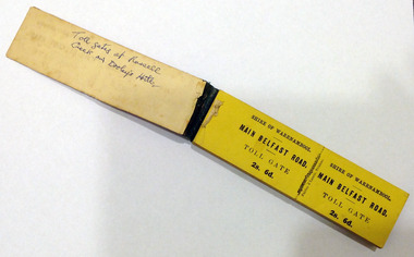 Warrnambool and District Historical Society Inc.
Certificate - Ticket Book, Main Belfast Road Toll, 2s 6d, 1860s
The Shire of Warrnambool operated toll gates from 1866 to 1869 as a means of revenue rai sing for road construction. There were three toll gate locations – on the main Belfast (Port Fairy) Road at Dennington Bridge, on the Woodford Road at Russells Creek and on the Geelong Road at the Allansford Bridge. The toll gates were unpopular and unprofitable for the lessees as travellers were able to avoid the tax by skirting around the gates. They had toll houses besides the gates. The printers of these tickets, Fairfax and Laurie were the lessees at the time of the Warrnambool Examiner newspaper. This paper, founded by Richard Osburne and John Wilkinson, and published with some gaps from 1851 to 1880, is a key source today of Warrnambool’s history at that time. These toll gates tickets are significant because:- 1. They date back to the 1860s and were only issued from 1866 to 1869. 2. They are the only artefacts we hold of the time when toll gates were operating in our local district 3. They are the best example of how the Shire of Warrnambool in its early history raised revenue for road building and maintenance This is a book of toll gate tickets for sale at the Main Belfast (Port Fairy) Road Toll Gate. The tickets (about 50) are yellow and in duplicate with provision to detach the outer ticket for the purchaser to keep. The tickets (two shillings and sixpence) are bound with an adhesive tape and the cover is mottled in pattern (brown and blue). There are also four loose tickets in blue (3 shillings). Back Cover: ‘136’ Tickets in book: ‘Shire of Warrnambool, Main Belfast Road, Toll Gate 2s 6d., Fairfax and Laurie, Printers’ Loose tickets: ‘Shire of Warrnambool, Main Belfast Road, Toll Gate, 3s.’ shire of warrnambool, toll gates -
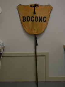 Kiewa Valley Historical Society
Banner - Bogong
Banners were used at schools on sports days to identify the school and/or the team. Bogong is a local town between Mt Beauty and Falls Creek and was established by the State Electricity Commission of Victoria during the construction of the Kiewa Hydro Electric Scheme. The school was opened on 28th Jan. 1941 and closed c1986. The banner probably belonged to the Bogong school and was used for sport carnivals and other events that included mixing with other schools.Wooden pole with yellow/orange satin shield cover on top. Black satin cord with tassels on top and bottom front and back. Black satin letters hand stitched on to form 'Bogong'. Fine black cord around outer edge also hand sewn.Bogongbanner; bogong state school; sport carnivals -
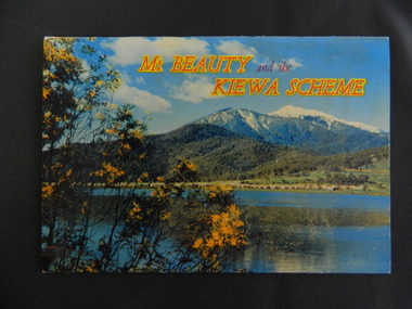 Kiewa Valley Historical Society
Booklet - Mt Beauty and the Kiewa Scheme x2
This booklet was produced to advertise Mt Beauty, the Kiewa Scheme & surrounding areas to visitors / tourists. The photos cover Falls Creek with snow, lifts and skiers - one with Spion Kopje Lodge. Also Tawonga Camping ground, Bogong Village, Mt Beauty Chalet, the Control panel at Kiewa Power Station, Clover Dam at No. 3 Power Station, the road to Falls Creek and a view of Mt Beauty township. The photos indicate what Mt Beauty and the Kiewa Valley and High Plains looked like c1950's during the construction of the Kiewa Hydro Electric Scheme. The area was recognised and encouraged as a tourist attraction especially Falls Creek enabling comparison with later photos and ideas. A fold down booklet postcard size of 12 colored photos - back to back of Mt Beauty, the Kiewa Scheme & surrounds. They fold in to form a front photo with title and a back card for stamp & address of addressee. On the back of the front photo are a few paragraphs describing the beauty, history and 'things to do' in the area for the visitor / tourist. mt beauty; kiewa scheme; tawonga; bogong; clover dam; kiewa valley; bogong high plains