Showing 1505 items
matching bridge street bridge
-
 Orbost & District Historical Society
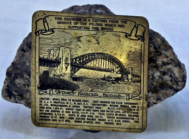
souvenir, 1925
Souvenir piece of granite from one of the pylons supporting Sydney Harbour Bridge. Small information plate.souvenir sydney-harbour-bridge civic-memento -
 Flagstaff Hill Maritime Museum and Village
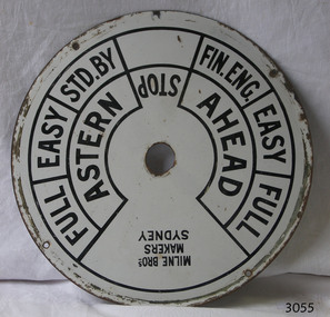
Equipment - Ships' Telegraph section, Milne Brothers, Copper and Brass Works, Early-to mid-20th century
This Engine Room section of a ship's telegraph system was part of the equipment of the Ports and Harbour ship the SS Rip. The vessel serviced and maintained the lights and buoys at Port Phillip Bay and Queenscliffe. The SS Rip was possibly the former gunboat "Albert". The ship’s communication system that was used from the late 19th century to early-to-mid-20th-century is called an Engine Order Telegraph (E.O.T.) or ship’s telegraph. The system has two parts, the Bridge Section and the Engine Room Section. The Bridge Section is usually mounted on top of a pedestal, and the Engine Room Section is often attached to a vertical surface. The standard commands printed or stamped onto the dial are the directions of AHEAD and ASTERN, and the speeds of STOP, FULL, EASY, STD. BY. and FIN. ENG. The ship’s pilot on the Bridge of a vessel sends his Orders for speed and direction to the to the Engine Room with the E.O.T. He moves the lever or levers, depending on the number of engines the ship has, to change the indicator on the Bridge Section’s dial to point in the new direction and speed of travel. This change causes the Orders to be duplicated on the Engine Room Section’s dial and a bell to signal the change simultaneously. The engineer then adjusts the ship’s engines and steering equipment to follow the pilot’s Order. The manufacturer, Mulne Bros., was a copper and brass works at 166 Sussex Street Sydney, in December 1892, and previously from 1870 at 128 to 130 Sussex Street. The company made and sold a wide range of equipment including machinery and gauges for the Railways.The Engine Room section is significant for being part of the communications system on the ship SS Rip, owned by Melbourne's Ports & Harbours department and used to service and maintain the navigation signals of Port Phillip Bay and at Queenscliffe in the mid-20th century. The dial is an example of marine equipment made in Australia and used for the safety of Victorian vessels. It is also significant for being made by an early Australian manufacturer, Milne Brothers of Sydney.Engine Room Section of a ship’s telegraph or Engine Order Telegraph (E.O.T.). The round metal dial has inscriptions stamped around the edges. The inscriptions are nautical terms for direction and speed and include the maker’s details. The dial was made by Milne Bros. of Sydney. It was part of the equipment on the "SS Rip" in Victoria.Black paint around dial: "MILNE BROS. / MAKERS / SYDNEY" "FULL EASY STD. BY " "FIN ENG. EASY FULL" ""ASTERN" "STOP" "AHEAD"flagstaff hill, warrnambool, maritime museum, maritime village, great ocean road, shipwreck coast, marine technology, marine communications, engine order telegraph, e.o.t., ship’s telegraph, bridge section, engine room section, ship’s engine telegraph section, marine telegraph, milne bros., milne brothers, sydney, copper and brass works, ports & harbours ship, ss rip, gunboat albert, service ship, maintenance ship -
 Orbost & District Historical Society
black and white photograph, c1920-1954
This is a copy of "THE BRIDGE AT BOGGY CREEK, NOWA NOWA, LAKE TYERS." which is a Rose Stereograph Co postcard. Boggy Creek Bridge was built in 1916 as part of the Bairnsdale to Orbost extension to the main Gippsland Railway, and is situated in the middle of the township of Nowa Nowa, crossing a steep-sided and well-timbered creek-valley. This section of the line closed in 1987. This bridge plays a major part in the identity and history of the town of Nowa Nowa, This item is associated with the East Gippsland Railway.A large black / white photograph of a large wooden bridge across a creek. There is a house and outbuildings in the background on the right. It is in a bush setting. on back - "Boggy Creek bridge - Nowa Nowa 1887 LaTrobe Collection"boggy-creek-bridge east-gippsland-railway -
 Orbost & District Historical Society
black and white photograph, first half 20th century
This appears to be the Boggy Creek bridge and to have been taken at Nowa Nowa. The Boggy Creek Bridge was built in 1916 as part of the Bairnsdale to Orbost extension to the main Gippsland Railway, and is situated in the middle of the township of Nowa Nowa, crossing a steep-sided and well-timbered creek-valley. This section of the line closed in 1987.This bridge plays a major part in the identity and history of the town of Nowa Nowa, since Boggy Creek’s steep sided valley divides the township into two components. It is part of the East Gippsland Railway line.A black / white photograph of a bridge across a creek. A young man in a suit is standing in the foreground.boggy-creek-bridge-nowa-nowa -
 Orbost & District Historical Society
black and white photograph, Rose Stereograph Company, first half 20th century
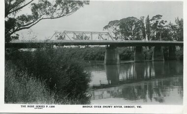
... Orbost & District Historical Society Ruskin Street Orbost ...A new bridge over the Snowy River at Orbost was opened for traffic on June 20th 1922. It was a new timber and steel girder structure, a joint Country Roads Board — Victorian Railways venture and was built and completed at a cost of £41,000 (the steel girders came from the Flinders Street viaduct reconstruction). Subsequently it was decided not to take the railway across the river, and the bridge was only ever used by road traffic. Postcards form a vital part of social and historical records for researchers. This postcard is a pictorial record of an earlier bridge across the Snowy River at Orbost.A black / white postcard photograph of a bridge over the Snowy River at Orbost.0n front - The Rose Series P1200 copyright Bridge Over Snowy River Orbost Vic.snowy-river-bridge -
 Orbost & District Historical Society
black and white photograph, Howard D. Bulmer, first half 20th century
... Orbost & District Historical Society Ruskin Street Orbost ...A new bridge over the Snowy River at Orbost was opened for traffic on June 20th 1922. It was intended as a road and rail bridge, and was again partly washed away by flood waters in 1934. After the end of the first World War the Victorian Railways considered an extension of the railhead across the river at Orbost, and in 1922 a new timber and steel girder structure, a joint Country Roads Board — Victorian Railways venture, was built and completed at a cost of £41,000 (the steel girders came from the Flinders Street viaduct reconstruction). Subsequently it was decided decided not to take the railway across the river, and the bridge was only used by road traffic. This is a pictorial record of an early bridge over the Snowy River at Orbost.A black / white postcard photograph of a bridge across a shallow river with men on horseback underneath.snowy-river-bridge -
 Orbost & District Historical Society
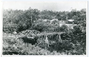
Photograph - Photograph. black + white
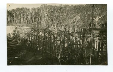
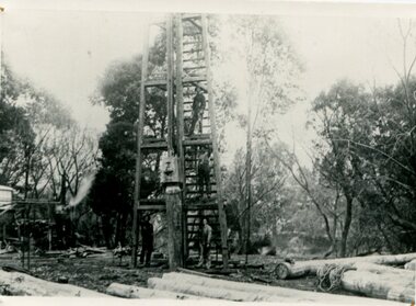
The Stony Creek Trestle Bridge was built in 1916 when the existing rail line from Melbourne to Bairnsdale was extended to Orbost. This 97km Bairnsdale to Orbost extension through rugged terrain was reputed to have been the most difficult rail project undertaken in Victoria. In service for over 60 years the bridge was damaged by bushfire in 1980, with the last train crossing in 1987. At 247m long and 20m high, it is the largest standing bridge of its kind in the State, and is listed on the Register of Historic Sites. Built of red ironbark and grey box timber, it is a fine example of the early engineering skills that utilised the resources and materials found on site. (More information Newsletter July 2013)Built during the period 1914-16, of Gippsland Grey Box and Red Ironbark, the Stoney Creek bridge on the East Gippsland Railway is a fine example of early engineering skilll , being constructed without the aid of any of the modern machinery available today. This is a rare photograph and of high significance in showing the bridge under construction.Landscape format black + white photograph (unframed). Four pin holes in each corner, tear to top left quadrant and fold / crease top to bottom in centre of image.construction, 1916, railway bridge, timber industry, trestle construction, stony creek bridge, east gippsland, bairnsdale to orbost line -
 Orbost & District Historical Society
black and white photograph, 1977?
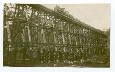
In 1977 great efforts were being made to preserve this bridge, the highest trestle bridge in Victoria at Stoney Creek. The Stony Creek Trestle Bridge was built in 1916 when the existing rail line from Melbourne to Bairnsdale was extended to Orbost. This 97km Bairnsdale to Orbost extension through rugged terrain was reputed to have been the most difficult rail project undertaken in Victoria. In service for over 60 years the bridge was damaged by bushfire in 1980, with the last train crossing in 1987. At 247m long and 20m high, it is the largest standing bridge of its kind in the State, and is listed on the Register of Historic Sites. Built of red ironbark and grey box timber, it is a fine example of the early engineering skills that utilised the resources and materials found on site.The Bairnsdale to Orbost rail line contains the most varied range of timber & timber composite bridges on any Victorian line. The Stoney Creek bridge is listed on the Victorian Heritage Register for its architectural and historical significance.A black / white photograph of a very large trestle bridge. a steam locomotive, with loaded goods trucks, is on the bridge. stoney-creek trestle-bridge railway east-gippsland-railway -
 Orbost & District Historical Society
black and white photograph, 1934
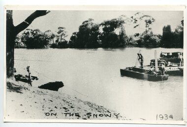
This photograph shows vehicles and people being ferried across the Snowy River during the 1934 flood. The Orbost punt was reinstated on a temporary basis following damage to the bridge. Damage estimated at £500,000 was caused by the 1934 floods in the Orbost district. This 1934 flood was devastating, destroying a section of the 1922 Orbost bridge, wrecking fences, bridges and roads, dumping silt and debris on the rich river flats and drowning cattle. The centre span of the Orbost Bridge was washed away.This is a pictorial record of the effects of the 1934 floods in the Orbost district.A large black / white photograph of a punt with a motor vehicle and people making their way across a river.on front - "On the Snowy 1934"snowy-river-orbost flood-1934 river-transport-punt -
 Orbost & District Historical Society
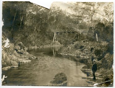
black and white photograph, C1890
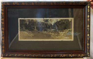
This photograph shows the construction of the first bridge over the Snowy River at Orbost being built. a copy was also donated by Gil and Heather Richardson. The first pile bridge over the Snowy River was just completed by Mr Jim Granter when the 1891 flood took out the centre,. There were differences of opinion as to whether the council should pay . The Shire Secretary, Mr John Draffin, persuaded them to honour their obligations. Mr Granter and Mr Clarke finished it as a suspension bridge which was opened by Mrs William Watt. Soon after a mob of cattle stampeded, the weight snapped the cable, letting one side sag. Mr R.P. Cameron repaired it and this bridge remained until 1922. "In 1890 the contract for a bridge was let to Mr James Granter for £1450. This structure with additions and improvements made to it was to cost the ratepayers about £2,500, and its erection was proceeded with in a very satisfactory manner until, just as the greater-part of the work had been completed, the flood of 1891 came down on it, piling up mountains of logs, timber and debris against the piers, which had not been made wide enough apart to allow for. contingencies of this kind. The structure held out bravely until the turn of the flood and then gave way with a crash, about five bays from the centre disappearing in the stream." ( Snowy River Mail August 12 1893)This is a pictorial record of the construction of the first bridge over the Snowy River.A black / white photograph of four men working on the construction of a new bridge and its pylons a man is standing on a timber tower/ derrick. There are logs in the foreground, trees in the background. sheds on the left and possibly a steam engine.on back - "first bridge - 1st pile being driven"snowy-river-bridge granter-jim bridge -
 Orbost & District Historical Society
black and white photograph, 1920s
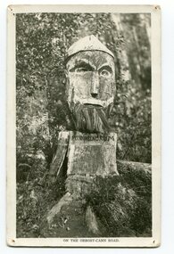
Pons asinorum was the name given to a wooden carving made by road worker Finlay Munro in the early 1920s at Boulder Creek, on the old Princess Highway, between Orbost and Cann River. The carved face was said to mock the supervising engineer after an argument about putting the road alignment across a swamp that required new bridges. The Italian workmen had advocated for a different route to avoid the need for building new bridges across the swamp. This photograph is from a set of thirteen black and white postcards in a fold-out format.This is a photograph of an iconic tourist attraction which records the woodworking skills of workers in the early 20th century. The carving is no longer there.A small black / white photograph of a face carved into a tree stump.on front at bottom - ON THE ORBOST CANN ROADwoodcarving pons-asinorum boulder-creek-east-gippsland princess-highway -
 Orbost & District Historical Society
black and white photograph, first half 20th century
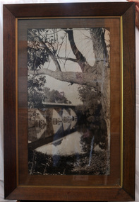
This is a bridge across the Snowy River at Orbost. This bridge was built in the 1920s as a road and rail bridge, and was partly washed away by flood waters in 1934. After the end of the first World War the Victorian Railways considered an extension of the railhead across the river at Orbost, and in 1922 a new timber and steel girder structure, a joint Country Roads Board — Victorian Railways venture, was built and completed at a cost of £41,000 (the steel girders came from the Flinders Street viaduct reconstruction). Subsequently it was decided not to take the railway across the river, and the bridge has only been used by road traffic.This is a pictorial record of an early bridge across the Snowy River at Orbost.A very large black / white photograph under glass in a timber frame. It is of a bridge across a river and is framed by trees.bridge snowy-river-bridge road-transport-orbost -
 Orbost & District Historical Society
framed black and white photograph, C1920
... Orbost & District Historical Society Ruskin Street Orbost ...Boggy Creek Bridge was built in 1916 as part of the Bairnsdale to Orbost extension to the main Gippsland Railway, and is situated in the middle of the township of Nowa Nowa, crossing a steep-sided and well-timbered creek-valley. This section of the line closed in 1987. This item is a pictorial record of the Boggy Creek railway bridge on the East Gippsland line. This bridge plays a major part in the identity and history of the town of Nowa Nowa, since Boggy Creek’s steep sided valley divides the township into two components.A black / white photograph of a bridge across a river in the bush. It is under glass in a brown wooden frame which has gold decorated edges. There appears to be a man sitting on rocks in the right front foreground.on front of photograph - "Nowa Nowa Creek, Gippsland, Victoria, Sears, Copyright"boggy-creek-nowa-nowa east-gippsland-railway bridge-rail -
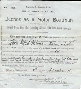 Warrnambool and District Historical Society Inc.
Document, Licence Motor boatman, 1918
This is a licence issued to Leslie Palmer in 1918. It gives him authority to operate a motor boat across the banks of the Hopkins River near the mouth and to carry passengers. As there is a bridge at the mouth of the river it is assumed that this motor boat was used to go across the river from a private house, making it more convenient than going by road to cross the bridge. It was, and still is, a common practice to use boats to cross the river from private homes built along the banks of the Hopkins River.This is a significant item as it is an original certificate and is interesting because the licence was a restricted one, for use only in crossing the Hopkins River. This is a paper licence issued by the Marine Board of Victoria in 1918. The certificate has printed material and entries written in black ink. It has the seal of the Marine Board and the signature of the SecretaryWritten material: ‘Leslie Alfred Palmer of Warrnambool, oil, on the Hopkins River within a line bearing east from Point Ritchie on the western side of the mouth of such river to the opposite shore, 6th December 1918’ motor boat licence 1918, warrnambool, leslie palmer, hopkins river -
 Warrnambool and District Historical Society Inc.
Financial record - Ledger, Warrnambool Shire Council 1899-1918, Circa 1900
Provides a collection of letters to the President and Councillors of the Shire of Warrnambool from J. M. Crawley. The period covered is 1900 to 1918. It covers such topics as repairs to bridges, purchasing of equipment, complaints, applications for roads. Names of places and structures include Dennington Bridge, Cassidy’s Bridge, Warrumyea Bridge, Yangery, Purnim. Loose within the book is a letter from a W,M(H?) Clarke of Garvoc. The letters contained in this ledger provide information on a large range of works which were carried out in the Shire in the early 1900’sDark olive green fabric cover with tan spine and cornersMinute Book in gold lettering on red background on spine.warrnambool shire council 1899-1918, crawley j w crawley, warrnambool shire offices, warrnambool -
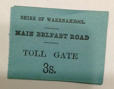
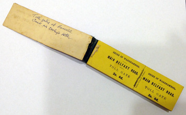 Warrnambool and District Historical Society Inc.
Certificate - Ticket Book, Main Belfast Road Toll, 2s 6d, 1860s
The Shire of Warrnambool operated toll gates from 1866 to 1869 as a means of revenue rai sing for road construction. There were three toll gate locations – on the main Belfast (Port Fairy) Road at Dennington Bridge, on the Woodford Road at Russells Creek and on the Geelong Road at the Allansford Bridge. The toll gates were unpopular and unprofitable for the lessees as travellers were able to avoid the tax by skirting around the gates. They had toll houses besides the gates. The printers of these tickets, Fairfax and Laurie were the lessees at the time of the Warrnambool Examiner newspaper. This paper, founded by Richard Osburne and John Wilkinson, and published with some gaps from 1851 to 1880, is a key source today of Warrnambool’s history at that time. These toll gates tickets are significant because:- 1. They date back to the 1860s and were only issued from 1866 to 1869. 2. They are the only artefacts we hold of the time when toll gates were operating in our local district 3. They are the best example of how the Shire of Warrnambool in its early history raised revenue for road building and maintenance This is a book of toll gate tickets for sale at the Main Belfast (Port Fairy) Road Toll Gate. The tickets (about 50) are yellow and in duplicate with provision to detach the outer ticket for the purchaser to keep. The tickets (two shillings and sixpence) are bound with an adhesive tape and the cover is mottled in pattern (brown and blue). There are also four loose tickets in blue (3 shillings). Back Cover: ‘136’ Tickets in book: ‘Shire of Warrnambool, Main Belfast Road, Toll Gate 2s 6d., Fairfax and Laurie, Printers’ Loose tickets: ‘Shire of Warrnambool, Main Belfast Road, Toll Gate, 3s.’ shire of warrnambool, toll gates -
 Warrnambool and District Historical Society Inc.
Document - Main Belfast Road Toll Gate Ticket Collection, 1860s
The Shire of Warrnambool operated toll gates from 1866 to 1869 as a means of raising revenue for road construction. There were three toll gate locations – on the main Belfast (Port Fairy) Road at Dennington Bridge, on the Woodford Road at Russells Creek and on the Geelong Road at the Allansford Bridge. The toll gates were unpopular and unprofitable for the lessees as travellers were able to avoid the tax by skirting around the gates. They had toll houses besides the tollgates. The printers of these tickets, William Fairfax and Henry Laurie, were the lessees at the time of the Warrnambool Examiner newspaper. This paper, founded by Richard Osburne and John Wilkinson, and published with some gaps from 1851 to 1880, is a key source today of Warrnambool’s history at the time. These toll gate tickets are significant because:- 1. They date back to the 1860s and were only issued from 1866 to 1869 2. They are the only artefacts we hold of the time when toll gates were operating in our local district 3. They are the best example of how the Shire of Warrnambool in its early history raised revenue for road building and maintenance. These are eleven toll gate tickets, ten for the Belfast (Port Fairy) Road toll gate and one for the Woodford Road toll gate. One is mounted on a Swintons store label (6 pence) and four are mounted on cardboard (2 shillings, sixpence, and two shillings and sixpence) and six are loose (three shillings, two shillings and sixpence and threepence). The Belfast Road tickets are yellow, green, blue and cream and the Woodford Road one is white. All have black printing. There is also an undated newspaper cutting with information on the toll gate tickets. Belfast Tickets: Shire of Warrnambool, Main Belfast Road, Toll Gate and the price Woodford Road: Shire of Warrnambool, Woodford Road, Toll Gate, 1s 6d Six of the eleven tickets also have ‘Fairfax and Laurie, Printers’ The sixpence ticket on card has the name R P Christian in ink written on the back of the card. shire of warrnambool, toll gates, r p christian, woodford road, main belfast road, swintons pty ltd -
 Warrnambool and District Historical Society Inc.
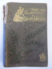
Book, Glimpses of South America, 1882
This book was given as a Sunday School prize to James Cassady. The donor was William Wines. The Wines families were pioneers in the Woodford district. James Cassady was the son of William and Elizabeth Cassady and the family lived at Boughton on the Merri River (near Cassady’s Bridge, Caramut Road today). This property was established about 1845. Charley and Joe, whose names have also been written in the book, were James’ brothers. This book is of interest because it belonged to James Cassady, the son of pioneer settlers in Cassadys’ Bridge/Woodford area. This is a hard cover book of 220 pages with 32 extra pages at the back of the book giving information on other books produced by the same publisher. The cover is grey-green with gold lettering, green and black floral decorations and gold images of two men on horseback and a South American Indian chief. The spine is torn away at the top and the cover and pages are stained and crumpled. There are many black and white illustrations throughout the text, with the frontispiece protected by a piece of tissue. The inscriptions are handwritten in black ink and pencil.‘Woodford Sunday School presented to James Cassidy (sic) by his well-wisher William Wines’ (this is re-written underneath in pencil with the correct spelling of ‘Cassady’) ‘Chaley cassady, boughton, merri river (sic) “Joe’ james cassady,, boughton, william wines, woodford sunday school, history of warrnambool -
 Warrnambool and District Historical Society Inc.
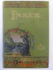
Book, Frank, Late 19th century
This book was given as a prize in 1892 to Joseph Cassady from the Cassady’s Bridge State School. This school, once located near Cassady’s Bridge on the present-day Caramut Road, was opened on 19th January 1891 and closed in December 1892. The first teacher was Janet Ada McDougall and the teacher when the school closed was J. H. Delahenty. The Cassady family had the farm, Boughton and this was established about 1845 on the Merri River near where the bridge is today. Joseph was born in 1882 to William and Elizabeth Cassady.This book is of considerable importance as it is the only memento we have of Cassady’s Bridge State School. This school only existed for two years.This is a hard cover book of 208 pages. The cover is green with coloured borders and a coloured sketch of a stream and a bridge. The lettering on the front cover and the spine is gold and the pages are gilt-edged. The cover is much faded. Some of the back pages are partly torn away. The book has two black and white sketches at the front of the book and 28 chapters of story. The inscription is handwritten in black ink and the inscription page is stained. ‘State School Cassady’s Bridge Xmas 1892 Presented to Joseph Cassady 3rd Class for Good Progress. J.H. Delahenty Head Teacher’ cassady family, boughton, history of warrnambool -
 Warrnambool and District Historical Society Inc.
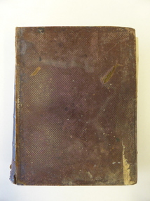
Book, The Domestic liturgy & family chaplain, 1846
This book belonged to John Cowtan. He was a purchaser of land near Cassady’s Bridge in Warrnambool and an important and early settler in Port Fairy. The land that John Cowtan selected was bought by Williaam Cassady whose sister, Ann, was married to John Cowtan. Cassady established the property, Boughton where Cassady’s Bridge is today. This book came from a Cassady estate sale early in the 21st century. Between 1839 and 1844 John Cowtan was a ship’s captain for John Griffiths, a shipowner and entrepreneur. In 1844 Cowtan established a merchant trading and produce business in Port Fairy with John Bland. In the 1860 John Cowtan went to live in Melbourne.This book is of great interest because of its early date (one year after the founding of Warrnambool) and because of its association with John Cowtan, a pioneer settler of Port Fairy with connections to Warrnambool.This is a brown leather cover book of 385 pages. The spine has gold lettering. The binding has come apart and has been mended with white cotton material on the inside of the cover. The insides of the cover have a brown, white, blue and yellow mottled pattern. The cover is stained and torn at the edges and has a deep gouging on the front. The first page has been torn and mended with tape and some of the pages are stained. There are two pressed fern fronds, one loose newspaper cutting and a bookmark with a sepia-coloured image, lace paper edges and coloured embroidery contained within the pages. The book has a preface and 58 chapters. The inscription is handwritten in black ink. ‘J. Cowtan 1848’ john cowtan, port fairy history, william cassady -
 Warrnambool and District Historical Society Inc.
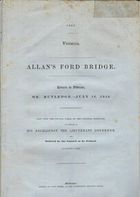
Document, Allan’s Ford Bridge 1852, 1852
This is an original Victorian Government document containing the printed version of 37 reports and letters regarding the building of the first Allansford bridge completed early in 1852. The correspondence dates from October 1850 to February 1852 and includes letters and reports from Melbourne Government employees such as Robert Hoddle, Chief Surveyor, David Lennox, Superintendent of Bridges and Lieutenant – Governor Charles La Trobe. The correspondence from local settlers included the names of William and John Allan, John Davidson and James Coulstock. The correspondence shows that some settlers in the Warrnambool/Port Fairy district wanted a portion of the Government allocated funds spent on the local roads and bridges in other locations. The 1852 Allansford bridge cost £480 and was replaced in 1870. This document has strong historical significance as it relates to one of the earliest State government works in the district and records the public imput into the decision.. It contains opinions and correspondence between a number of early settlers in the district at the time.Grey/blue paper document with black text. 21 pages plus 4 page index at back.allan's ford 1852, allansford bridge, allansford, history of allansford, warrnambool -
 Warrnambool and District Historical Society Inc.
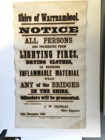
Document, Shire of Warrnambool Fire - Washing-Bridge 1882, 1882
This notice relates to the prohibition of lighting fires,drying clothes or bringing inflamable material near any of the bridges in the shire. Offenders will be prosecuted. With a date of 1882 and the fact that bridges were mostly made of wood, it would have been of concern that the destruction of bridges was not only of great inconvenience but also of considerable expense. But the reality of bridges providing shelter and warmth in the colder months and the ensuring fires and burnt bridges has more than likely precipitated this notice. J W Crawley was shire engineer from 1876 until 1895 and for 10 of those years he trained his son J W Crawley who succeeded his father and served in the position for 40 years.He in turn was succeeded by his son Rolf Crawley in 1935. In 1963 the bridge over the Hopkins Falls at Wangoom was named the Crawley bridge in honour of service to the Shire of Warrnambool by members of the Crawley family. The Shire of Warrnambool was proclaimed in 1863 and covered an area of over 600 square miles. Much of it was incorporated into the Moyne Shire in the 1990's with some being included into the boundaries of City of Warrnambool. This banner is an interesting piece of history. It shows the issues confronting early settlers such as shelter and the chores of daily life but also the importance placed on infrastructure which was slowly taking place around the district. It was in the era of drainage and roadworks and hence bridges were an important part of that infrastructure. The name J W Crawley is one of importance in the Warrnambool district for his service over many years. Rectangular piece of cloth printed in black ink. The back is plain.Shire of Warrnambool By order of J W Crawley Shire Engineer, 13th November 1882. Thos Smith gas Printing Works Koroit Street Warrnambool.warrnambool, shire of warrnambool, bridges of warrnambool shire, j w crawley, warrnambool shire engineer, crawleys of warrnambool -
 Warrnambool and District Historical Society Inc.
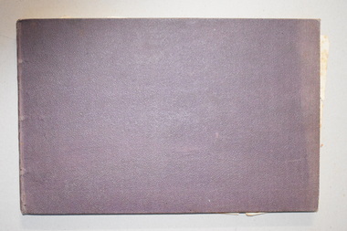
Ledger, Letters on Suspension Bridges, 1890s
This book contains information on the building of suspension bridges and dates from the 1890s. It belonged to John William Crawley Junior, an engineer, surveyor and architect in private practice in Warrnambool and also the engineer for the Shire of Warrnambool from 1895 to 1935. The information in the book comes in the form of lectures on suspension bridge making and these were sent to John Crawley by his tutor or coach, Arnold Lilley (Lilly). Arnold Lilley was an Oxford mathematician working in Victoria and it is said that he coached or trained 95% of the municipal surveyors in Victoria in the 1890s. John Crawley has obviously had this material bound into a book and it was passed on to his son, Rolf, who was the engineer for the Shire of Warrnambool from 1935 to 1968. It then came into the possession of Michael Hand who took over the private surveying business of Rolf Crawley in Warrnambool. The Warrnambool and District Historical Society acquired the book, along with several Crawley ledgers and letter books, from the estate of Michael Hand. This book is of interest as it contains lectures and other material on the building of suspension bridges and belonged to John William Crawley Junior, an engineer for the Shire of Warrnambool for 40 years. It also is a memento of the work of Arnold Lilley who produced the material on suspension bridges and coached John Crawley in his surveying studies.This is a hard cover book with a purple cover. The cover is slightly faded. The book contains handwritten material regarding the building of suspension bridges and includes sketches, lectures on suspension bridges and pages with postage stamps on them. There are three loose pages. ‘’Letters on Suspension Bridges Arnold Lilly Esq. Coach J Wm. Crawley Pupil’john william crawley junior, warrnambool, rolf crawley, warrnambool, shire of warrnambool, arnold lilley, teacher of surveying. -
 Port of Echuca
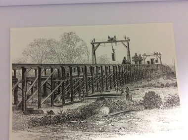
A black and white photograph of a drawing, Black and white photograph of a drawing depicting the construction of the iron Murray Bridge, at Echuca, showing Surveyor, bridge workers, hoists, a crane, and much activity, 1981
Original negative and photograph held by The Age, before by Orm Cook, Echuca. Photo is of a drawing of Bridge work taking place in 1877, across Murray River at Echuca. Orm Cook gave The Age the photograph in 1981 as the round arches on the bridge were about to be removed.A bridge crossing of the Murray River was needed by 1877. It linked Echuca and Moama in a more tangible way. The bridge was funded privately and public use of it was discussed for the next several years.A black and white photograph of a drawing, depicting the construction of the iron Murray Bridge at Echuca, showing the Surveyor, the bridge workers, hoists , a crane, and much activity.Written in pen on the back, "Murray Bridge at Echuca under construction. Original to 'Age' came from Orm Cook. Also the numbers 6530 written in pen. Also on the back is a rectangular stamp with these words inside the rectangle. "COPYRIGHT. This photograph may not be reproduced without permission in writing from the Editor of "The Age" 250 Spencer Street, Melbourne, and 39/41 York St, Sydney.murray river, bridge work, bridge construction, bridge workers., the age newspaper., orm cook. -
 Port of Echuca
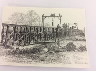
Photograph - Black and white photograph of a drawing, A black and white photograph of a drawing of the construction of the bridge crossing the Murray River at Echuca in 1887, 1981
The drawing shows all the activity and building roles involved in building a bridge in 1877. The crossing of the Murray River was very important to citizens living in both Echua, but especially those living in Moama and in further NSW regions as it provided them with access to Victorian market regions. The bridge was built privately for Deniliquin farmers, but eventually opened up to the general public.This is significant because it represents the roles of different tradesmen in the construction industry in the late 19th Century. It also shows construction stages . Bridge pylons are being inserted into the fiver banks. It is also a very well produced drawing, the artist is anonymous, but very skilled.A photograph of a drawing of the construction of the bridge crossing the Murray River in 1877. The picture shows surveyors, construction workers, crane operators, hoists and a crane and much activity.Written on the back in pen are the numbers 6530. In pencil are the numbers 61/8"? and 10"?. Stamped on the back is a small rectangle with the words 'COPYRIGHT. This photograph may not be reproduced without permission in writing from the Editot of "The Age" 250 Spencer Street Melbourne, and 39/41 York St., Sydney.' written inside it.bridge works, murray river crossing, moama, echuca, orm cook collection, 'the age' newspaper., deniliquin farmers, engineering, bridge building, pylons, 1877 -
 Port of Echuca
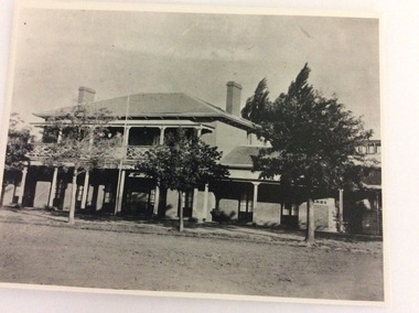
A black and white photograph, The Bridge Hotel, in 1896, showing Silky Oak trees, 1970's
The Bridge Hotel was built by Henry Hopwood to house visitors to the town crossing the Murray River on his punt crossing, which was situated just below the Bridge Hotel on the Murray River. The accommodation was spacious and grand! In the right back corner of the photograph, the 'lantern' roof of the St Georges Hall can be seen. The street is level with the front entrance to the Hotel, which is very different to what it is today.The photograph shows hotel activities and accommodation in the late 19th Century.A black and white photograph of the Bridge Hotel taken from the Hopwood Gardens. The photograph shows four silky oak trees growing along the front of the building. There is an empty flag pole outside the front of the building. The right wing advertises billiards, whilst the left wing apparently was a bar.Written on the building can be seen the words; HOTEL and BILLIARDS. Written in pen on the back of the photograph are the words "Bridge Hotel. Probably 1896, showing Silky Oak trees.bridge hotel, henry hopwood, silky oak trees, lantern roof, st georges hotel -
 Port of Echuca
Photograph - Black and white photograph, Late 1970s
Relates to a series of 5 photos:P000094-P000098 of the front of the Bridge Hotel on the corner of Murray esplanade and Hopwood gardens. These photos, taken about 1976, were before the Port Restoration Scheme renovated the hotel. The Bridge Hotel was built by Henry Hopwood in 1858. This and the Bond Store were Echuca's first 2 brick buildings. Named from Hopwood's nearby pontoon bridge. The building was bought be The Council in 1970. Restored and reopened in 1975.The Bridge Hotel is an important part of Echuca's settlement and development. It was originally built by Henry Hopwood, the European founder of Echuca, in 1859. Hopwood built the hotel to provide accommodation to people using his punts across the Campaspe and Murray rivers that area central to the landscape of the Port. The hotel was situated on the land between both rivers and punts and provided for a variety of levels of accommodation from grand rooms to very basic rooms. At the time of the photos the hotel was 120 years old and became an important part of the Port of Echuca tourism. Black and white photograph of the Bridge Hotel , showing western wing before restoration.Stamped on the reverse "Gazemore Studio, D. G. Gay, 18 Frances Street Echuca 3625.bridge hotel, echcua, port restoration scheme, bridge hotel restoration, echuca -
 Port of Echuca
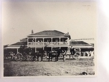
Photograph, Approx. 1970's
The Bridge Hotel was built by Henry Hopwood to house visitors to the town crossing the Murray River on his punt , which was situated just below the Bridge Hotel on the Murray River. The accommodation was spacious and grand! In the right back corner of the photograph, the 'lantern' roof of the St George's Hall can be seen. The street is level with the front entrance to the Hotel, which is very different to what it is today.The photograph shows hotel activities and accommodation in the late 19th Century. The Bridge Hotel was a very busy place as can be seen with women on the balcony, a stage coach full of people, laden carts and buggies.The Bridge Hotel Echuca - photo taken looking south towards front of building. Four people can be seen on the balcony and several gathered under the verandah. In the foreground are several horse-drawn carriages. The road in front of the hotel is unmade and very wide, with the roof of St.George's Hall seen over the right (western) wing of the hotel. Verso: Bridge Hotel, 1860s? St. George's Hall in background.bridge hotel, henry hopwood, lantern roof, st.george's hall, 1870s -
 Eltham District Historical Society Inc
Photograph, Fay Bridge, United Service Station, Main Road, Eltham, 26 August 2019
fay bridge collection, 2019-08-26, cockatoos, diamond street, eltham, luck street, main road, united service station -
 Eltham District Historical Society Inc
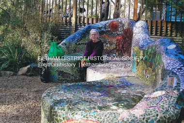
Photograph, Fay Bridge, Fay Bridge with the Lasting Memories Mosaic Seat, St. Andrews Hall, 1 Proctor Street, St. Andrews, n.d
The Lasting Memories Mosaic Group Seat is part of Nillumbik Shire Council's Public Art. Following the Black Saturday Bushfire of February 7, 2009, which ravaged St Andrews and surrounding district, a group of bushfire affected women formed the Lasting Memories Mosaic group and created this concrete seat covered in mosaic as part of their healing process. It was completed in 2012. For more information see Nillumbik Shire Council's link Public Art: Lasting Memories Mosaic GROUP, Lasting Memories Mosaic Seat - https://victoriancollections.net.au/items/58536395d0ce201b746561c6fay bridge collection, fay bridge, mosaics, st andrews, lasting memories mosaic group seat, st andrews hall